Tauranga Harbour Recreation Strategy - August 2008 Environmental Publication 2008/09 - Bay of Plenty ...
←
→
Page content transcription
If your browser does not render page correctly, please read the page content below
Tauranga Harbour Recreation Strategy
             August 2008
             Environmental Publication 2008/09
             ISSN 1175 9372

GDS08-2537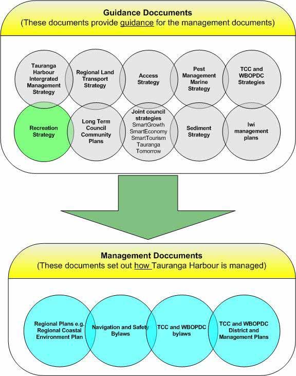
Environment Bay of Plenty                                                                         i

                                    Acknowledgements

                    Project Team: Robin Britton, Lauren Schick, Ben Lee,
                    Aileen Lawrie, John Whale, Peter Watson, John Rauputu,
                    and Campbell Larking.

                    Thanks to:

                    Department of Conservation – Rotorua and Tauranga
                    (Chris Staite, Ron Keyser), Environment Bay of Plenty
                    Councillors and staff, Environment Bay of Plenty
                    Harbourmasters       past    and    present    (Jon Moore,
                    John Dickinson and Carl Magazinovic), Forest and Bird
                    (Basil Graeme and Eddie Orsulish), Forest Lady Barge (Abe
                    Auqaha), Heybridge Developments Limited (Ian Dunstan),
                    Historic Places Trust (Rachel Harfield), Hoe Aroha Whanau
                    o Mauao, Hui attendees at Ngati Te Wai, Hui attendees at
                    Rereatukahia Marae and Wairoa Marae, Katikati Boating
                    Club     (Keith Pyle),   Katikati   Sea     Scout   Group
                    (Russell Warner), Maori questionnaire respondents,
                    Maritime New Zealand, (Jim Lott, John Dickinson), Ministry
                    of Fisheries (Craven Dunn, Dave Allen), Northern Harbour
                    Action Team (Sam Dunlop, David Olgilvie, Rosalie Smith,
                    Syd Hopkins), Oceanz City Management (Mandy Scott-
                    Mackie), Omokoroa Boat Club (John Budden), Port of
                    Tauranga Limited (Nigel Drake, Ian Gorrie), Priority 1
                    (Tauranga        Economic       Development        Agency)
                    (Andrew Coker), Respondents to the Tauranga Harbour
                    Beaches Survey, SmartGrowth (Management Group),
                    Tauranga Airport Authority (Ray Dumble), Tauranga Bridge
                    Marina (Tony Arnold), Tauranga City Council Councillors
                    and staff Tauranga City Council Councillors and staff,
                    Tauranga Game Fishing Club (Ian Thomas), Tauranga
                    Marina Society (Bob Ellis), Tauranga Moana Iwi Customary
                    Fisheries Committee, Tauranga, Moana Tangata Whenua
                    Collective (Tauranga City Council), Tauranga Rowing Club
                    (Mark James), Tauranga Yacht Club (Fred Jeanes), Te
                    Tawa Quays (Ian Dustin), Toi Te Ora Public Health
                    (Annaka Simpson),         Waimarino       Rowing      Club
                    (Dennis Crowd), Waimarino.com (Blair Anderson and Grant
                    Gaffaney), Western Bay of Plenty District Council
                    Councillors and staff, and Western Bay of Plenty District
                    Council Maori Forum, Nga whanau no te moutere o
                    matakana/ Matakana Island Resource Management Unit/
                    tangata whenua no Te Awanui.

Environmental Publication 2008/09                              Tauranga Harbour Recreation Strategy
Environment Bay of Plenty iii
Executive Summary
This strategy explores the issues for recreation on Tauranga Harbour and sets out a series of
actions to improve recreation opportunities and reduce conflict, while maintaining the quality of
the environment. It is a joint strategy between Environment Bay of Plenty, Tauranga City Council
and Western Bay of Plenty District Council.
The need for the strategy arose from SmartGrowth and the Tauranga Harbour Integrated
Management Strategy. They identified the impacts of recreation are not well understood, we
need better planning for recreational activities, and planning needs to be a joint effort between
the community and the three councils.
The vision for the strategy is: “Recreation on Tauranga Harbour is, enjoyable, safe, sustainable,
and accessible to all: A set of goals and principles set out how the vision is to be achieved and a
framework for decision making.
The discussion of the issues and observations for recreation on the harbour are split into five
areas:
• harbour margins;
• navigation safety;
• boating facilities;
• the environment; and
• how we can work together better.
The action plan sets out what the three councils will do. Associated with each action is an
explanation, who will lead it, estimated cost and timeframe. Some of the more significant actions
include developing an Access Strategy, a designated on-the-water recreation event area,
extending the Anzac Bay boat ramp, limiting horse and vehicle access to the foreshore, and
setting up a Recreation Forum.
Most of the actions will be implemented as part of existing planned work. For those actions that
have not been planned for, each council will need to consider and adopt them in their respective
Long Term Council Community Plan (LTCCP) and Annual Plan. The Recreation Forum will
monitor implementation of the actions.
Environmental Publication 2008/09 Tauranga Harbour Recreation StrategyEnvironment Bay of Plenty v
Contents
Acknowledgements .............................................................................................. i
Executive Summary............................................................................................ iii
Chapter 1: Introduction ......................................................................................7
1.1 Tauranga Harbour ............................................................................................7
1.2 Recreation ........................................................................................................8
1.3 Why do the strategy?...................................................................................... 10
1.4 Who manages recreation?.............................................................................. 11
Chapter 2: Where does the strategy fit? .................................................... 13
2.1 Community outcomes ..................................................................................... 13
2.2 Other plans and strategies.............................................................................. 13
Chapter 3: Vision for recreation on Tauranga Harbour ........................ 17
Chapter 4: What’s happening now?............................................................. 19
4.1 Harbour margins ............................................................................................. 19
4.2 Navigation safety ............................................................................................ 20
4.3 Boating facilities.............................................................................................. 23
4.4 The environment............................................................................................. 25
4.5 How we can work together better ................................................................... 29
Chapter 5: What we will do ............................................................................. 31
5.1 Harbour margins ............................................................................................. 32
5.2 Navigation safety ............................................................................................ 34
5.3 Boating facilities.............................................................................................. 38
Environmental Publication 2008/09 Tauranga Harbour Recreation Strategyvi Environment Bay of Plenty
5.4 The environment ............................................................................................ 40
5.5 How we can work together better................................................................... 41
Chapter 6: How will the Strategy be implemented?............................... 45
Appendices .......................................................................................................... 47
Appendix 1 – Key Agencies and Documents ............................................................ 49
Appendix 2 – Our Discussions.................................................................................. 51
Appendix 3 – Boating on Tauranga Harbour............................................................. 53
Appendix 4 – Proposed Monitoring Programme ....................................................... 57
Appendix 5 – Bibliography ........................................................................................ 61
Figures
Figure 1 The blue line represents the regional land area and is indicative only
of the harbour area covered by the Strategy. .................................... 9
Figure 2 Management of Tauranga Harbour.................................................. 15
Tauranga Harbour Recreation Strategy Environmental Publication 2008/097
Chapter 1: Introduction
The Tauranga Harbour Recreation Strategy sets out how we want to manage and enhance
opportunities for recreation on Tauranga Harbour, over the next ten years. It is a joint effort
between our three councils – Environment Bay of Plenty, Western Bay of Plenty District Council
and Tauranga City Council. This Strategy is a non-statutory document prepared under the Local
Government Act, 2002.
1.1 Tauranga Harbour
Tauranga Harbour (the harbour) covers an area of 218 square kilometres. It
encompasses the tidal stretch of water between Matakana and the North Island
mainland. At the south eastern end of the harbour is the landmark Mauao and the city
of Tauranga. At the north western end are the small coastal settlements of Athenree
and Bowentown (Figure 1 is indicative of the harbour area covered by this Strategy).
There are two main basins within the harbour, joining in the area between Matahui
Point (on the mainland) and Tirohanga Point (on Matakana Island). These middle
reaches are only navigable two hours either side of high tide. At low tide this area is dry
– people can walk to and from Matakana Island.
The tides have a major influence over how the harbour is used. At low tide 60% of the
harbour is very shallow or dry, making deep water a limited resource, but providing
extensive exposed areas for a range of ecological and recreational values and uses.
Tauranga Harbour is known to tangata whenua as Te Awanui. Te Awanui is the rohe
moana of three iwi - Ngāti Ranginui, Ngāi Te Rangi, Ngāti Pūkenga. Most of the marae
of these iwi are located close to the harbour margins. The mauri of the harbour is
extremely important for the customary relationship tangata whenua have with the
harbour, in particular customary food gathering.
Te Awanui – Tauranga Harbour: Iwi Management Plan has been developed and it will
be an important linking document to managing issues on this harbour into the future.
Tauranga Harbour is an outstanding natural feature and landscape, an outstanding
ecosystem for wildlife, including marine mammals, shorebirds and fisheries and is
recognised as a wetland of international importance for wading birds.
Environmental Publication 2008/09 Tauranga Harbour Recreation Strategy8 Environment Bay of Plenty
1.2 Recreation
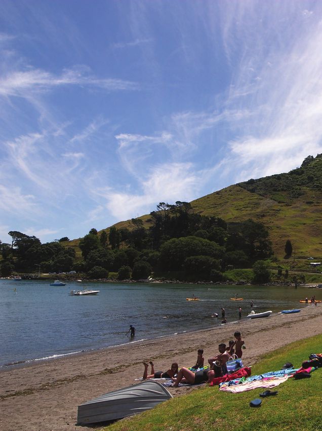
Every day people use the harbour for a variety of recreational activities including:
Activities involving boats or Activities not involving Passive enjoyment
equipment equipment
Sailing Kite boarding Walking/ running/resting/ Enjoying views,
Rowing Jet skiing exploring ambience and open
Paddling (e.g. Water skiing Playing space
Waka ama) Diving Picnicking Bird watching
Kayaking Windsurfing Swimming/ sunbathing
Fishing Wake boarding Fishing from wharves etc
Boating Land yachting Shellfish gathering
Game bird hunting Kite flying Dog walking
Golfing
Tauranga Harbour Recreation Strategy Environmental Publication 2008/09Environment Bay of Plenty 9
Figure 1 The blue line represents the regional land area and is indicative only
of the harbour area covered by the Strategy.
Environmental Publication 2008/09 Tauranga Harbour Recreation Strategy10 Environment Bay of Plenty
The recreational opportunities available on and around the harbour are a significant
attraction for people to live in and visit the western Bay of Plenty sub-region. The quality
of the physical environment and leisure/recreation opportunities are two of the top three
reasons why people move to this area1.
1.3 Why do the strategy?
It is great that so many people can use and enjoy the harbour. However with more and
more people moving to the western Bay of Plenty sub-region (the population will grow
33% over the next 15 years2), there are going to be even more people wanting to enjoy
recreation on the harbour. We want to encourage and provide for this demand, and to
do this we need to make sure that:
• People can easily access the harbour
• There are opportunities for a wide range of activities
• The impacts of recreation on the environment are minimised
• It’s safe for everyone
An inevitable consequence of high recreational use is conflict - between recreational
users and with other types of uses, e.g.:
• People that live around the harbour margins
• The port
• Commercial activities (such as ferry and charter services)
• Marinas
• Other boat-related service industries
• Tangata whenua customary activities
• Flora and fauna in and around the harbour
At the moment conflicts between harbour users are generally limited to high use areas,
for example, the southern entrance to the harbour, Pilot Bay and the Sulphur Point
area. There are still many other areas of the harbour where there is still plenty of space
for more recreational use.
The need for a strategy for recreation on Tauranga Harbour is identified in two existing
planning documents (SmartGrowth and the Tauranga Harbour Integrated Management
Strategy). Both documents identified that:
• The impacts and needs of recreation on Tauranga Harbour is not well
understood.
• As future use increases, we need better planning for recreational activities and
associated facilities.
1
Reasons for moving into and out of the Bay of Plenty Region, Migration Research Group, University of Waikato, September 2006.
2
Demographic Forecast 2051, Environment Bay of Plenty. August 2006.
Tauranga Harbour Recreation Strategy Environmental Publication 2008/09Environment Bay of Plenty 11
• Planning needs to be a joint effort between the community and the three councils
involved – Environment Bay of Plenty, Tauranga City Council and Western
Bay of Plenty District Council.
1.4 Who manages recreation?
There is a wide range of agencies responsible for managing recreation on and around
the harbour - Appendix 1 describes the responsibilities of all the key agencies.
Environment Bay of Plenty, Western Bay of Plenty District Council, and Tauranga City
Council play the biggest role in managing recreation on the harbour. Environment
Bay of Plenty is the prime agency with responsibility for managing activities on harbour
waters and making sure the quality of the waters is looked after. Western Bay of Plenty
District Council and Tauranga City Council are responsible for managing how and
where people access the harbour (e.g. boat ramps and reserves). The Ministry of
Fisheries is the other main agency – they are responsible for managing fisheries
including recreational fishing. The Department of Conservation also has a role in
reserve and marginal strip management around Tauranga harbour.
Environmental Publication 2008/09 Tauranga Harbour Recreation Strategy13
Chapter 2: Where does the strategy fit?
2.1 Community outcomes
Everything that a council does has to contribute to their Community Outcomes.
Community Outcomes are focussed on improving social, economic, environmental and
cultural wellbeing. Each council has its own ‘set’ of community outcomes which were
developed with their communities.
The community outcomes of the three councils advocate Tauranga Harbour as being
iconic, highly valued and central to all people and activities occurring in the western
Bay of Plenty sub-region. The most relevant community outcomes for the strategy are:
Tauranga City Council (Tauranga Tomorrow)
• The harbour, foreshore and waterways are clean and healthy and support
compatible cultural, social, economic and recreational opportunities
Western Bay of Plenty District Council (Smart Future)
• We can all enjoy a healthy and safe lifestyle
• Our environment is clean, green and valued
Environment Bay of Plenty (Community Outcomes, the Ten Year Plan 2006-2016)
• A clean and protected environment
• Healthy and safe communities
• A vibrant and fulfilling lifestyle
2.2 Other plans and strategies
The management, development and implementation of strategies and other actions
relating to Tauranga Harbour need to be implemented in a staged approach, rather
than trying to address all issues at once. These stages of work will in time, be combined
and provide a key basis for the overall management of the harbour. It is strongly
recognised that there are many inter-linkages between different harbour management
issues and areas. It is also recognised that some work will be guided by national
strategies such as the New Zealand Coastal Policy Statement.
Environmental Publication 2008/09 Tauranga Harbour Recreation Strategy14 Environment Bay of Plenty
The Recreation Strategy is therefore just one of a number of “tools” used by the
councils to help manage Tauranga Harbour – as shown in the following diagram (Figure
2). This Strategy is a first step in the path to managing current and future recreation
demands that will arise as a result of increased population growth of the sub-region. As
such it is not a static document, rather one that will be built upon over time. The
Strategy may result in a range of different outcomes. For example, changes to statutory
documents, education initiatives, operational actions or liaison with other agencies.
It is important to also realise that each of the three Councils involved in this Strategy
must build the recommended actions into their Long Term Council Community Plans
(LTCCP) and annual planning cycles. This will signal their commitment to undertaking
the actions.
Tauranga Harbour Recreation Strategy Environmental Publication 2008/09Environment Bay of Plenty 15
Figure 2 Management of Tauranga Harbour
Environmental Publication 2008/09 Tauranga Harbour Recreation Strategy17
Chapter 3: Vision for recreation on Tauranga
Harbour
The vision is a statement of what we want for recreation on Tauranga Harbour now and into the
future.
Vision:
‘Recreation on Tauranga Harbour is, enjoyable, safe, environmentally
sustainable, and accessible to all’
To achieve this vision, the Strategy sets out six goals. The goals are statements of where we
need to be heading to achieve the vision.
Goals:
• Recreation is a significant use on Tauranga Harbour.
• People have easy access for recreation on Tauranga Harbour.
• There are opportunities to experience a variety of recreational activities on
Tauranga Harbour.
• Tauranga Harbour is safe and enjoyable for all recreation users.
• Any adverse effects of recreation on other users, tangata whenua
customary activities and the environment are avoided or minimised.
• Management of recreation is co-ordinated, clear and efficient.
The principles are the fundamental values that we have about recreation on the harbour. They
will guide our decisions about what are the best ways to achieve the goals and the vision. The
following principles are not listed in any order of priority.
Principles:
• The recreational opportunities offered by the harbour are an integral part of the
economic, social, environmental and cultural wellbeing of the community.
• Access to and along the harbour is vital for providing for recreational opportunities.
• Education and enforcement are both necessary tools for ensuring safe recreational
use of the harbour.
• Surface and deep water space is at a premium and should be used efficiently,
having regard to competing uses.
Environmental Publication 2008/09 Tauranga Harbour Recreation Strategy18 Environment Bay of Plenty
• Designating areas for specific activities can be a clear and simple way of reducing
conflict.
• The harbour is a public domain available for the use of a wide range of activities.
• The importance of commercial shipping and transport operations is recognised.
• The types and popularity of recreation activities are always changing and any
management of the harbour must be flexible to meet these changes.
• Agency partnerships are fundamental to efficiently managing the harbour,
particularly where the use of land is closely linked to how the harbour is used.
• People will always have different expectations and aspirations on use of the
harbour and these need to be balanced between different users.
• A healthy harbour is fundamental for ensuring quality recreation.
• Recreational uses must not compromise or adversely affect the sustainability of the
harbour's natural and physical resources.
• The three Councils will work in a partnership to maintain and enhance recreational
opportunities, through the implementation of this and other harbour-related
strategies.
• Cultural sustainability and a healthy harbour environment are important for the
mauri of the harbour.
• The visual quality of the harbour and its margins is an important part of people’s
enjoyment of recreational experiences.
Tauranga Harbour Recreation Strategy Environmental Publication 2008/0919
Chapter 4: What’s happening now?
This chapter creates a picture of what is happening now for recreation on Tauranga Harbour. It
brings together what we know about recreation, from talking with a whole range of people,
including:
• Recreational groups and clubs
• Individuals that use the harbour
• Tangata whenua
• Commercial operators
• Government departments
• Council staff
(See Appendix 2 for details of who we talked to).
Five key themes emerged from our discussions:
• Harbour margins
• Navigation safety
• Boating facilities
• The environment
• How we can work together better
4.1 Harbour margins3
4.1.1 Access
Access is the single most important factor for providing opportunities for recreation on
and around the harbour. To encourage more use of the harbour, we need to make sure
that existing access is optimised and where possible, find new ways to access the
harbour. There are positive health outcomes for the community associated with easily
accessing physical activity opportunities.
3
NB: Issues relating to marinas, moorings, ramps and boating are covered in section 4.3 - Boating facilities.
Environmental Publication 2008/09 Tauranga Harbour Recreation Strategy20 Environment Bay of Plenty
We need to make sure there are access opportunities for a range of different people
including the elderly, disabled and young children. But we also need to balance this
with protecting parts of the harbour for their “ecological” values, e.g. kaimoana beds,
wetlands and bird roosting areas, and protecting the open space characteristics that
are a fundamental part of the recreational enjoyment of this harbour. Many of these
issues are controlled through the respective bylaws of Tauranga City Council and
Western Bay of Plenty District Council.
Both Tauranga City Council and Western Bay of Plenty District Council have a spread
of reserves and facilities (e.g. boat ramps and walkways) around the harbour margins
that provide access to Tauranga Harbour. Between the Councils there are a suite of
plans and strategies that guide how these reserves and facilities are managed.
Access to traditional Maori kaimoana areas and other customary sites in the harbour
has been reduced due to ongoing development around the harbour margins. Many of
the points of access were by way of long standing informal agreements with private
land owners. Subdivision has seen many of these informal agreements disappear.
People’s access to the harbour can have adverse effects on the environment. For
example people and their dogs can disturb high tide roosting and nesting birds, and the
use of vehicles on harbour beaches and foreshore areas can impact on shellfish beds.
The latter example is an emerging issue, particularly in the northern harbour when the
ramps are busy or are not useable at low tide. Both Tauranga City Council and Western
Bay of Plenty District Council have bylaws prohibiting horses on beaches, but no
controls on vehicles launching boats.
Environment Bay of Plenty has identified the need for an Access Strategy (Tauranga
Harbour Integrated Management Strategy and Ten Year Plan). The purpose of an
Access Strategy is to have a harbour wide strategic plan for maximising and
encouraging access, balanced against the need to minimise the adverse effects of
access on the environment (e.g. protection of high tide roosts, or access opportunities
for people to go fishing without a boat).
4.1.2 Future development (non-recreational) zones
Between the Regional Council and the Territorial Authorities, there has been little joint
strategic planning for developments that straddle land and water (e.g. marinas, boat
building/ servicing industries, ferry services, access structures). Consequently there are
some areas where there is limited integration between harbour margin and water based
zonings. This means there is limited guidance for such future developments. Although
this is not directly related to recreation issues, any such zoning would impact on
recreational access and use.
As examples, the demand for marinas and water-based transport is likely to increase in
the future. These types of development have both land and water based infrastructure
and impacts.
4.2 Navigation safety
4.2.1 Recreational watercraft activities
There has been very little research of watercraft activity on the harbour. The limited
research that has been done has looked at the total number recreational boats.
Approximately 20% of households in the Tauranga/Western Bay of Plenty Census area
have at least one boat (Maritime Safety Authority, 1999). This equates to 10,400 boats
in 2001 and projected to increase to 15,400 boats by 2021.
Tauranga Harbour Recreation Strategy Environmental Publication 2008/09Environment Bay of Plenty 21
Recreational watercraft activity on the harbour has changed over the last 10 years and
is expected to continue to change for the next 10 years. Anecdotal evidence from those
we talked with suggested the following recent trends:
• An increase in watercraft activity on the harbour
• An increase in the popularity of kayaking and waka ama
• More power boats and yachts using the harbour
• Jet skis are getting larger and faster; they now operate more like boats
• Significant growth in youth training activities
• Significant increase in the popularity of kite boarding and sail boarding
Even with the increase in users, many of the people we talked to considered that there
is still plenty of space in the harbour for more recreational watercraft activity. Others
however considered that space needed to be managed carefully as the channels and
shipping movements were important limitations. The increase in recreational use of the
harbour has the potential to disturb the habitat for birds.
4.2.2 Jet ski and ski lanes
There are nine ski lanes and two jet ski lanes in the harbour - refer to Appendix 3 for a
map showing their location. During our consultation, many people raised concerns
about:
• Erosion from the wake of boats and jet skis
• Effects on shellfish
• Danger to children swimming
• People using private land to launch vessels and base their skiing and jet skiing
activities from
• Conflicts with access to traditional Maori fishing and cultural activity areas
• The noise and activity can disturb people and in particular Marae ceremonies
Interestingly many of these lanes are located adjacent to Maori land and these issues
are of particular concern to tangata whenua. The location of jet ski and ski lanes is
always controversial. Any review of their location is a part of the Navigation Safety
Bylaws review (see below) and would require further discussions with the public.
4.2.3 Rules and roles
The Bay of Plenty Regional Navigation Safety Bylaws 2004 (Navigation Safety Bylaws)
set out rules about boating on the harbour. They are implemented by Environment
Bay of Plenty through the Harbourmaster, his deputies and volunteer harbour wardens.
The Navigation Safety Bylaws primarily focus on people’s recreational boating use of
the waters and cover a range of safety provisions (such as life jackets and speed of
vessels), provisions to manage uses (e.g. moorings management) and provisions to
avoid conflicts (such as ski lanes).
Environmental Publication 2008/09 Tauranga Harbour Recreation Strategy22 Environment Bay of Plenty
The Harbourmaster and his deputies enforce the Navigation Safety Bylaws. Many of
the people we talked to emphasised the importance of an enforcement ‘presence’ on
the water as a deterrent, especially at high use locations and during busy periods. (NB:
the volunteer harbour wardens have an education and advisory role not an enforcement
role.).
One of the difficulties with following up reported incidents is identifying vessels. One
solution to this problem is for all recreational vessels to be registered (or otherwise
identified) and have clearly displayed identification. A report by the Pleasure Boat
Safety Advisory Group in 1999 suggested that “registration” of recreational vessels was
not necessary at that time, because the safety to be gained from such a system would
not outweigh the costs of implementing it.
Education is important for people’s safety. People need to know the rules. As it’s such a
large harbour and there are lots of users, we can’t just rely on enforcement.
Environment Bay of Plenty widely distributes a Harbour Guide which provides a range
of navigation safety information for users. A number of the people we talked to
suggested that it was people from outside the local area who were the hardest to
educate about safe practices on the harbour.
Coastguard, Seacoms and the Port of Tauranga Limited are significantly involved in
safe navigation. All three organisations assist boaties, by providing continuous radio
services. The Port provides web-based information (for example shipping movements,
swell, and wind direction) for the southern entrance. However there is little information
available to boaties and the Coastguard to assist in safe crossings of the northern
harbour bar.
Interestingly, Coastguard undertakes approximately 10-20 and 70 rescues each year at
the northern and southern harbour entrances respectively. But over the past 10 years,
there has been a low level of accidents on the harbour that were reported to Maritime
New Zealand or to Environment Bay of Plenty.
4.2.4 Events and commercial operators
Approximately 180 events are held on the harbour each year. The Navigation Safety
Bylaws allow for areas of the harbour to be set aside for special events. The use of
council reserves to support these special events is approved by Tauranga City Council
and Western Bay of Plenty District Council.
There have been times when there’s been a lack of coordination between the councils
for processing and granting approvals for events, due to each council having different
systems. With increasing use of the Harbour, it would be more efficient to have a
system in place that allows councils to jointly approve events.
Space on harbour beaches and around wharves that can be used by commercial
operators is limited. Careful use of these areas is required to ensure conflicts are
avoided.
4.2.5 Designated area for recreational events
Waka ama and rowing groups suggested it would be a good idea to have a designated
recreation area where they could hold events e.g. rowing and waka ama. The area
between Tauranga Bridge and the rail bridge, in front of the Strand was the preferred
site, for a number of reasons:
• Good viewing from the Strand
Tauranga Harbour Recreation Strategy Environmental Publication 2008/09Environment Bay of Plenty 23
• Close to shops, restaurants etc
• Launching facilities close-by
• Good water depth close to shore
If this area is to be promoted for events where spectators can readily view the area, it is
desirable to avoid inappropriate use and development encroaching into the area.
Tauranga City Council’s Sport and Active Living Strategy has also identified the
provision of a designated recreation area adjacent to the Strand as an action to be
included in the CBD/Waterfront Development project. To create the area will likely
require the relocation of a number of moorings.
4.2.6 Navigational risk assessment
As part of the New Zealand Port and Harbour Marine Safety Code, Environment
Bay of Plenty has identified a range of risks. The ones relating to recreational activities
include:
• Vessels anchoring or stopped in the southern Harbour entrance
• Adverse weather conditions for events
• Crossing the northern bar
• Large vessels in conflict with leisure craft
• Surfers crossing the harbour entrance to get to Matakana Island
• People jumping off Salisbury Wharf
The Risk Assessment will be used to develop a Harbour Safety Plan. The Harbour
Safety Plan will set out actions to address the above risks (and the other risks identified
in the assessment which do not relate to recreational matters) and will be
complementary to Environment Bay of Plenty’s Bylaws and to the actions in this
Strategy.
4.3 Boating facilities
4.3.1 Parking and Boat Storage
This is the most significant issue affecting current use and future expansion of
recreational boating on the harbour. During busy periods, demand already exceeds
supply at many boat ramps around the harbour. Demand is only going to increase as
the western Bay of Plenty population grows, and there is limited harbour-side land
available for boat ramp parking.
Parking for boats launching in Tauranga City is being focused at Marine Park, Sulphur
Point. Tauranga City Council has already budgeted to re-design the layout of parking.
Most ramps in the northern harbour have extremely limited opportunities for associated
parking. Tanners Point is under intense pressure for parking. Western Bay of Plenty
District Council is currently preparing a concept plan for the Bowentown domain, which
will address some parking issues for this area.
Environmental Publication 2008/09 Tauranga Harbour Recreation Strategy24 Environment Bay of Plenty
At present parking of cars and boat trailers is managed on a ‘first in first served’ basis
and is generally free (no cost). Interestingly some trailer boats are increasing in size,
which means the trailers require larger parking areas. Boat stacks and dinghy racks will
come under increasing pressure to meet the demand for boat storage.
4.3.2 Ramps
There are 25 boat ramps in Tauranga Harbour. Of those, 14 are within Western
Bay of Plenty Council’s jurisdiction and 11 in Tauranga City Councils (refer to Appendix
3 for a map of ramp locations). Some of these ramps can’t be used by vehicles –
they’re used for launching smaller vessels like kayaks.
Babbage (1998) estimated there were 5,000 boats launched in the northern Harbour
between 26 December 1997 and 1 February 1998. Tauranga City Council reviewed its
boat ramps from an asset management perspective and showed over 200 launches per
day during March (Bickers, 1996).
Both Tauranga City Council and Western Bay of Plenty District Council have recently
undertaken cursory assessments of ramp usage and demand. Results from these
surveys were not available at the time of writing.
Sulphur Point is the main launching area for recreational boats in Tauranga City. A new
six-lane boat ramp is scheduled to be installed to the north of the existing ramps.
Ramps at Pilot Bay cannot accommodate any increased growth in use (due to parking
restrictions and current level of use by people).
Ramps in the northern Harbour are currently being used at maximum capacity
(particularly over the summer period). Many of the existing ramps have limited access
to deep water at low tide; Tanners Point is currently the main deep water access for the
northern Harbour. Western Bay of Plenty District Council are currently considering a
suitable location for a new all-tide ramp in the northern Harbour (including parking).
The Waihi Beach Ward Reserve Management Plan, contains an action to investigate
improving the launching facilities at Anzac Bay. The ramp does currently extend to low
water. Coastguard have concerns about improving facilities because of close vicinity of
strong currents – most engine failure occurs soon after launching.
Growth in Omokoroa is expected to be significant - the current population is 1,800 and
in the next 20 years it is expected to grow to 12,000. Western Bay of Plenty District
Council considers the present boat ramp and associated facilities are already at
capacity.
4.3.3 Moorings
There are currently 380 swing moorings allocated in the harbour. Environment
Bay of Plenty intends to realign some of the existing moorings over the next few years,
to provide for more efficient layout and possibly some further mooring places (i.e. no
expansion of space currently allocated, just better use of the existing areas). There is
very little deep-water space available for expanding the existing areas or creating new
mooring areas. It is acknowledged that moorings are an inefficient use of space
compared to marinas.
Tauranga Harbour Recreation Strategy Environmental Publication 2008/09Environment Bay of Plenty 25
4.3.4 Marinas
Within the harbour there are two marinas with a combined total of 1,050 berths:
(i) Sulphur Point, (which is owned by Tauranga City Council and operated as a not-
for-profit public service by the Tauranga Marina Society) is full and has an
extensive waiting list; and
(ii) Tauranga Bridge (which is commercially operated) is near full capacity.
Proposals have also been raised or discussed for further marinas: near the mouth of
the Wairoa River, Omokoroa, Kauri Point, Mangawhai Inlet, Matakana Island and at
Trinity Wharf.
Marinas are an efficient use of space for the berthage of boats within Tauranga
harbour, given the limited deep water access available and the likely increase in
demand from the associated population growth. They are also controversial
developments (environmentally, culturally and socially). Tangata whenua are generally
opposed to any further marinas in Tauranga Harbour.
It is therefore critical that there is a joint Council approach to planning for new marina
locations. However, the Councils also recognise that public debate would be best
undertaken through the Resource Management Act processes, as this is where a wide
range of conflicting values and environmental effects are considered.
4.3.5 Deep water access
There is currently no berthage in Tauranga Harbour for deep keeled boats (i.e. over 50
ft length and keels of 3-4 m) due to the lack of wharf space and water depth. This limits
the use of the area by the local boat building industry (i.e. sea trials are generally
undertaken from Auckland due to the lack of berthage). It also limits such vessels
visiting Tauranga (e.g. ocean-going yacht races). Tauranga City Council is currently
assessing the feasibility of various marine activities in the area beside the Tauranga
Bridge.
4.4 The environment
4.4.1 Mangroves and sea lettuce
The increase in the spread of mangroves has had an adverse effect on recreation.
Numerous people raised examples of places in the harbour where they used to swim
and collect shellfish, and which have now been taken over by mangroves Any
management of mangroves must take into account sensitive areas of the harbour and
be undertaken in accordance with the Regional Coastal Environment Plan and the
Resource Management Act, 1991.
Environment Bay of Plenty is in the process of implementing initiatives to assist
communities to manage mangroves. They include assisting estuary care groups with
obtaining resource consent for mangrove removal and exploring the potential for
mechanical harvest.
Environmental Publication 2008/09 Tauranga Harbour Recreation Strategy26 Environment Bay of Plenty
The community’s concerns with sea lettuce relates to it decomposing on the beaches
causing smell and potential health issues. It also affects people’s ability to walk along
the foreshore, gets caught up in recreational gear and boat propellers, and makes
swimming and other in-the-water activities unpleasant. Sea lettuce is a natural
phenomenon that gets washed up on the beaches intermittently. It appears to be
controlled by climatic conditions (Park, 1996).
All three councils are currently working out an agreement for how best to manage sea
lettuce. It is likely to include ongoing monitoring and cleanup at popular harbour
beaches.
4.4.2 Shellfish gathering and recreational fishing
Tangata whenua and other community groups are concerned that shellfish beds are
declining or disappearing. However, during community consultation, the Ministry of
Fisheries advised that shellfish beds were currently in good condition. Community
comments raised included:
• Cockles are getting smaller and are being depleted by spreading silt layers
• Scallop beds seem to be recovering since fishing rules pertaining to scallop take
were changed, however there are on-going concerns regarding the impacts of
recreational scallop dredging.
• Horse mussels near Otumoetai have disappeared
• Some shellfish beds in the harbour seem to have been affected by land yachts,
horses and water skiing
• Some shellfish beds are considered by some people to be unfit to eat from time
to time
The Ministry of Fisheries is responsible for the management of fisheries and its habitat,
including assessing stock numbers to make sure that harvesting is sustainable.
Environment Bay of Plenty is responsible for managing habitat and biodiversity in the
harbour. These roles are closely linked. Toi Te Ora also has a role in ensuring shellfish
meet public health requirements. In conjunction with the three Councils and NZ Food
Safety Authority, they are currently undertaking a study to assess the microbiological
quality of shellfish in estuarine areas .
The Minister of Fisheries has appointed 55 Kaitiaki for the gazetted rohe of Tauranga
Moana Iwi, which includes the harbour. Within this area, the Fisheries (Kaimoana
Customary Fisheries) Regulations 1998 apply. The Tauranga Moana Iwi Customary
Fisheries Committee has been established to represent the interests of the Kaitiaki. The
Kaitiaki authorise customary takes within the gazetted rohe.
There is a Maataitai Reserve application in progress around Te Maunga o Mauao which
excludes commercial fishing and provides for the management of all non-commercial
fishing through Bylaws. A memorandum of understanding has just been signed
between the Ministry of Fisheries and Mai I Nga Kuri a Wharei Ki Tihirau Regional
Fisheries Forum. This provides a platform for iwi to become involved in fisheries
management issues.
Tauranga Harbour Recreation Strategy Environmental Publication 2008/09Environment Bay of Plenty 27
Commercial fishing was an issue that many people we talked to were concerned about.
There are currently approximately six drag netting licenses in existence, however these
will be phased out over time as they expire or are no longer used. Restrictions are
placed on the existing commercial operators re: season (approximately May to October)
and methods. No new commercial fishing can take place within the Harbour. However
this is a Ministry of Fisheries function. The Councils therefore can only advocate and
promote the prohibition of commercial fishing, while being mindful that some types of
commercial harvesting may be acceptable, e.g. the taking of sea lettuce. The Regional
Coastal Environment Plan already has policy and methods targeted at promoting the
sustainable management of fisheries.
Recreational fishing is one of the more popular recreational activities on the harbour.
Surveys by the Ministry of Fisheries found on average 21 boats fishing in the southern
harbour and 15 in the northern harbour, at any one time during daylight hours, on
weekends and holidays.
A number of people raised concerns that there are currently limited opportunities for
fishing by people who don’t have a boat (i.e. from wharves, jetties, marina breakwaters
etc). Concerns were also raised relating to the effects of recreational scallop dredging.
4.4.3 Horses and vehicles on the foreshore
During consultation for this strategy, concerns were raised about vehicles and horses
on beaches and the foreshore due to the impacts they can have on shellfish e.g. titiko.
They can also have adverse effects on estuarine vegetation.
In a number of locations in the northern harbour, vehicles drive across the mudflats to
launch and retrieve boats, particularly when the ramps are busy. In the southern
harbour the concern is more about the use of land yachts e.g. in Rangataua Bay.
There have been various horse training and trekking operations in the harbour. Some of
these operations have been closed down due to the impact they have on shellfish.
Both Tauranga City Council and Western Bay of Plenty District Council are currently
reviewing their bylaws on these matters. These bylaws cover the whole of the Tauranga
harbour (including below MHWS).
4.4.4 Water quality
When it comes to recreation, water quality is important for two reasons - ensuring that
shellfish is healthy and fit to eat and that the water is safe to swim and recreate in. It’s a
common perception that water quality in the harbour is getting worse. Research
suggests that although there have been fluctuations of some aspects that are
monitored (e.g. nutrient levels), that overall water quality has changed little over the last
14 years (Scholes, 2005).
Environment Bay of Plenty undertakes monitoring of water quality in the harbour (for
example by bathing beach sampling, sampling in a variety of other locations, and
monitoring of stormwater and sewage discharges). While Environment Bay of Plenty
monitors the health of shellfish in the harbour, Toi Te Ora Public Health is responsible
for issuing health warnings advising people about shellfish quality and algal blooms.
Tauranga City Council and Western Bay of Plenty District Council are responsible for
erecting notices about these health warnings.
Environmental Publication 2008/09 Tauranga Harbour Recreation Strategy28 Environment Bay of Plenty
Environment Bay of Plenty manages discharges to the Harbour through its Regional
Coastal Environment Plan and resource consents. The Regional Coastal Environment
Plan prohibits discharges of sewage from boats within Tauranga Harbour. There is a
sewage pump-out facility at Tauranga Bridge Marina. Environment Bay of Plenty
manages on-site septic tanks and associated discharges.
Environment Bay of Plenty undertakes a bathing water quality programme over the
summer, testing at various sites within the Tauranga Harbour. The latest survey results
are available online at the Environment Bay of Plenty website. The previous year’s
results have indicated that there are no areas of the harbour where swimming would be
dangerous because of the water quality.
There are various other things we’re also doing to deal with water quality:
• Environment Bay of Plenty has prepared a “Stormwater Strategy for the
Bay of Plenty Region”, 2005. This strategy outlines issues and management
directions for addressing stormwater quality.
• The effects of sprays and chemicals in the water are being addressed through
actions in the Tauranga Harbour Integrated Management Strategy.
• Environment Bay of Plenty implements Stream Care and Estuary Care
programmes.
• Environment Bay of Plenty is implementing the On-Site Effluent Treatment
Regional Plan to reduce the discharge of untreated sewage.
• Tauranga City Council is undertaking re-vegetation of stream banks in the
Kopurererua Valley, to assist in improving stormwater discharge quality.
• Environment Bay of Plenty, TCC and WBOPDC are involved in policy and
practical issues related to the management of mangroves in Tauranga harbour.
This work recognises the critical link mangroves have in terms of water quality
and sediment control.
4.4.5 Sedimentation and dredging
The community is concerned at the rate the harbour was infilling with sediment.
Sedimentation is a natural process within the Tauranga Harbour; however this process
can be significantly affected by human activities. The impacts sedimentation has on
recreation includes a loss of many inner harbour sandy beaches (because they have
been covered in “mud”) and the infilling of channels which limits navigation.
The sedimentation issue was identified and discussed in some detail in the Tauranga
Harbour Integrated Management Strategy. One of the responses has been for
Environment Bay of Plenty to initiate an extensive study looking at sediment sources
and transport in the harbour, so that there is a better understanding of this issue to
guide decision-making under the Resource Management Act. This will result in a
Sediment Strategy being developed.
Environment Bay of Plenty has undertaken a cost-benefit analysis of dredging seven of
the main recreational channels (Welsh, 2002). The cost of undertaking the dredging
was estimated to be between $4.05 million and $6.4 million and the benefits estimated
to be $15.59 million. Environment Bay of Plenty considered undertaking the dredging,
but at this point in time has decided that it isn’t a priority and therefore no funding has
been allocated. This will be reviewed once the sediment study has been completed.
Tauranga Harbour Recreation Strategy Environmental Publication 2008/09Environment Bay of Plenty 29
The Port of Tauranga Limited (entrance and Cutter channels), Tauranga City Council
(Pilot Bay), Western Bay of Plenty District Council (Tanners Point) and Tauranga
Bridge Marina currently have consents to undertake localised dredging to clear boating
channels or to facilitate access to ramps, the port and marinas.
4.4.6 Biosecurity and pest management
As more leisure craft and large commercial vessels use the Harbour, there is increased
potential for the introduction and spread of marine pests. Biosecurity threats of concern
include: undaria, asian date mussel, sea squirt and Didemnum vexillum.
Biosecurity matters are addressed primarily under the Biosecurity Act. In accordance
with this Act, Environment Bay of Plenty has a Regional Pest Management Strategy
which includes a section on marine pests. Environment Bay of Plenty takes a three-
pronged approach to pest control: education/surveillance/incursion control.
When undaria arrived in the Port entrance, it was removed by hand. However, as it is
common up the coast to the north, it is unlikely that it will be kept out of Harbour in the
long-term.
Boat trailers are the biggest “spreader” of marine weeds. There is a boat wash facility at
the Sulphur Point ramps. However boat wash down areas are only about 70% effective,
as they only remove the obvious organisms and not the plant fragments that can exist
for many weeks/months in damp crevices. Education is therefore critical for increasing
awareness about the threat of marine weeds and the necessary actions people can
take to mitigate the spread.
There is some community concern that the number of black swans was increasing and
having adverse effects on the environment, e.g. eating sea grass. However, game birds
are managed under the Wildlife Act 1953 for recreational hunting. The Tauranga
Harbour Integrated Management Strategy discusses this issue in some detail.
4.5 How we can work together better
4.5.1 Forum
During consultation on this strategy many people (including tangata whenua) signalled
that they wish to be more formally involved in making decisions about the future
management of Tauranga Harbour. At present there is no forum which enables various
parties, (e.g. tangata whenua, community groups, recreational clubs) to meet and
discuss issues relating to the recreational use of the harbour. In addition to providing a
vehicle for discussions, such a forum could provide advice to councils and ensure that
the strategy is implemented.
4.5.2 Pilot Bay
Pilot Bay has more conflicts between users than any other location in the harbour.
Users include swimmers, waka ama, dinghies accessing moored boats, kayakers, small
sailing boats, jet skis, water skiers and other vessels coming and going from the boat
ramp. Some users of Pilot Bay have suggested that it should be zoned into different
areas e.g. a swimming zone close to the shore and a non-powered (e.g. kayaks and
waka ama) vessel zone on the outside of the swimming zone, but landward of the
mooring zone. There was also suggestion made that the mooring area should be
reduced to allow more space for non-powered recreation. Suggestions like this need to
be discussed between all users of Pilot Bay to ensure all issues are openly discussed
and to see if the various interests can be accommodated.
Environmental Publication 2008/09 Tauranga Harbour Recreation Strategy30 Environment Bay of Plenty
4.5.3 Information presentation
Information (e.g. signage and web based information) about issues relating to Tauranga
Harbour is currently presented separately by all the agencies involved in different
management aspects of the harbour. For example at one boat ramp there may be a
sign from the Ministry of Fisheries for fish catch limits and a sign from Environment
Bay of Plenty about safe navigation. There is an opportunity to consider a more
integrated approach to sharing and delivering information to the public.
4.5.4 Monitoring
At present there is little data gathered on recreational use of the harbour. What
information that is gathered, is not gathered in any consistent form and is not
comprehensive across the whole harbour. As discussed earlier, the Ministry of
Fisheries have completed a survey of recreational fishing in the harbour including aerial
counts of boats and boat ramp surveys (at the time of writing the full report was not
publicly available). Tauranga City Council and Western Bay of Plenty District Council
have also undertaken short term boat ramp usage surveys. Environment Bay of Plenty
has also undertaken surveys relating to recreational use in some areas. More robust
information will be required to understand the issues and for managing increasing
recreational use in the future. Good quality information is essential to allow us to work
out how and where to better provide opportunities for future recreational needs.
Tauranga Harbour Recreation Strategy Environmental Publication 2008/0931
Chapter 5: What we will do
This chapter sets out the Action Plan i.e. what we’re going to do. The actions relate to each of
the themes identified in the previous section of the strategy and each action is set out as follows:
• What we will do - the action. NB: these tables only outline “new” actions and not existing
actions that are already being done by the respective Councils.
• Why will we do it - the reasons why we are doing the action.
• Who will lead it - for each of the actions, a lead agency is identified (in bold) to facilitate
and implement the action. Where there are multiple agencies identified, there would be
joint discussions and agreements on how best to progress the action.
• What will it cost - indicative costs have been estimated (ie as at 2007). Unless otherwise
stated, the quoted amount covers the period when the action will be implemented.
• When will it be done – sets out when the action will be implemented. Dates quoted relate
to the financial year, for each agency.
Environmental Publication 2008/09 Tauranga Harbour Recreation Strategy32 Environment Bay of Plenty
5.1 Harbour margins
When will it be
What we will do? Why will we do it? Who will lead it? What will it cost?
done?
5.1.1 Access Strategy
Develop an Access Strategy to include: We want to improve and encourage EBOP, TCC and Not budgeted. 2008/2009to
access to the harbour while protecting WBOPDC 2010/2011
• Provision of key access links to the Harbour in biodiversity and natural character
all neighbourhoods (including potential use of values. We also want to make sure that Total - $100,000
paper roads). everyone has a common view on how
and where we will provide for access to EBOP - $60,000
• Protection and restoration of areas that are the harbour in the future.
important for plants or wildlife from TCC - $20,000
inappropriate or excessive access, (e.g. WBOPDC - $20,000
dotterels at Panepane Point, restrictions on
dogs).
• Opportunities for fishing are increased
(especially for people who don’t have boats).
• Education opportunities (including signage).
• Identifying increased opportunities for
interactive recreation between shore and
water, such as tidal pools and pontoons.
• Access for people to passive recreational
opportunities such as the enjoyment of
beaches and recreational areas for the general
public (including possible mangrove removal
to facilitate this).
• Provision of access opportunities and
structures to meet the needs of disabled
people.
• Additional opportunities for walking access
along the shoreline.
Tauranga Harbour Recreation Strategy Environmental Publication 2008/09You can also read