Sentinel-3 OLCI Marine User Handbook - This Document is Public - Eumetsat
←
→
Page content transcription
If your browser does not render page correctly, please read the page content below
Sentinel-3 OLCI Marine User Handbook

 This Document is Public

 EUMETSAT
Doc.No. : EUM/OPS-SEN3/MAN/17/907205 Eumetsat-Allee 1, D-64295 Darmstadt, Germany
 Tel: +49 6151 807-7
Issue : v2G e-signed Fax: +49 6151 807 555
Date : 12 March 2021 http://www.eumetsat.int
WBS/DBS :

 © EUMETSAT
 The copyright of this document is the property of EUMETSAT.
EUM/OPS-SEN3/MAN/17/907205
 v2G e-signed, 12 March 2021

 Sentinel-3 OLCI Marine User Handbook
 This Document is Public

Page left intentionally blank

 Page 2 of 48
EUM/OPS-SEN3/MAN/17/907205
 v2G e-signed, 12 March 2021

 Sentinel-3 OLCI Marine User Handbook
 This Document is Public

Document Change Record

 Issue / Date DCN. Changed Pages / Paragraphs
 Revision No

 V1E 1 December 2017 First issue

 V1F 5 January 2018 Correction of minor typos

 V1H 04 July 2018 Rearranging sections and text for consistency with
 SLSTR and SRAL handbooks (products and
 processing sections now separated).
 New section on history of ocean colour. Updated
 cross referencing.
 Addition of coda rep information.
 L1 processing section updated to latest product
 notices 14/03/2018.
 Formatting and minor typological updates. New
 section on coverage. Updated tense of text
 concerning S3B.

 V2B 25 February 2020 Addition of new coverage maps and updating
 information on S3B as required. Updates on
 processing baselines, formatting and consistency
 with other S3 handbooks.

 V2D 19 February 2021 Version not released

 V2G 12 March 2021 Updates reflecting baseline collection 003 changes in
 processor.

 Page 3 of 48
EUM/OPS-SEN3/MAN/17/907205
 v2G e-signed, 12 March 2021

 Sentinel-3 OLCI Marine User Handbook
 This Document is Public

Table of Contents
1 INTRODUCTION........................................................................................................................ 6
 1.1 Purpose ........................................................................................................................... 6
 1.2 Scope .............................................................................................................................. 6
 1.3 Document Structure ......................................................................................................... 6
 1.4 Applicable Documents ...................................................................................................... 7
 1.5 Reference Documents ...................................................................................................... 7
 1.6 List of Abbreviations, Acronyms and Symbols................................................................. 10

2 BACKGROUND ....................................................................................................................... 12
 2.1 The Copernicus Programme........................................................................................... 12
 2.2 European Organisation for the Exploitation of Meteorological Satellites (EUMETSAT) .... 12
 2.3 Sentinel-3 objectives ...................................................................................................... 13
 2.4 Disclaimer ...................................................................................................................... 13
 2.5 Useful links..................................................................................................................... 14
 2.6 History of product changes ............................................................................................. 14

3 SENTINEL-3 AND OLCI .......................................................................................................... 15
 3.1 Ocean colour: a brief historical background .................................................................... 15
 3.2 Complementarities with other ocean colour missions ...................................................... 16

4 OLCI: GEOPHYSICAL VARIABLES, INSTRUMENTS AND PRINCIPLE................................. 17
 4.1 Ocean colour coverage of all aquatic environments ........................................................ 17
 4.2 Instrument coverage ....................................................................................................... 17
 4.3 Ocean colour measurement principles ............................................................................ 18
 4.4 OLCI instrument specifics ............................................................................................... 20
 4.5 Calibration and validation activities ................................................................................. 21
 4.6 Where to go for further information on the algorithms...................................................... 23

5 PROCESSING LEVELS AND SCHEMES ................................................................................ 24
 5.1 Level-1 processing approach .......................................................................................... 24
 5.2 Level-2 processing approach .......................................................................................... 25

6 OLCI PRODUCTS AND FILE TYPES ...................................................................................... 29
 6.1 Product timeliness .......................................................................................................... 29
 6.2 File naming .................................................................................................................... 29
 6.3 Data format .................................................................................................................... 30
 6.4 Level 1 product contents ................................................................................................ 30
 6.5 Level 2 product contents ................................................................................................ 32
 6.6 Product features and limitations...................................................................................... 36

7 HELPDESK, DATA ACCESS AND TOOLS ............................................................................. 37
 7.1 Registration .................................................................................................................... 37
 7.2 Helpdesk and Training.................................................................................................... 37
 7.3 Data Access Methods..................................................................................................... 37
 7.4 Software Tools ............................................................................................................... 39
 7.4.1 Sentinel-3 Toolbox ................................................................................................... 39
 7.4.1.1 Installing the toolbox ........................................................................................... 39
 7.4.1.2 Opening a Sentinel-3 product .............................................................................. 39
 7.4.1.3 Basic functionality ............................................................................................... 40
 7.4.2 METIS ...................................................................................................................... 40

8 DATA QUALITY ...................................................................................................................... 41

9 UPDATES TO PROCESSING BASELINES AND REPROCESSING CAMPAIGNS ................. 42

10 FREQUENTLY ASKED QUESTIONS ...................................................................................... 43

 Page 4 of 48
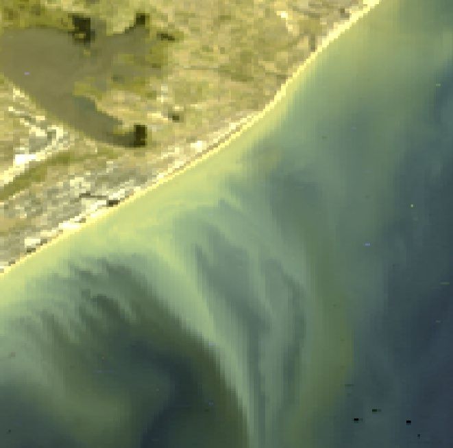
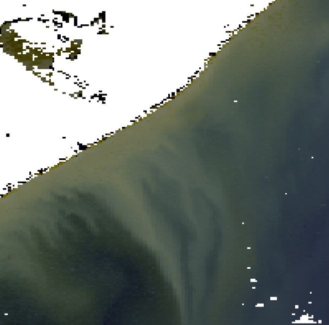
EUM/OPS-SEN3/MAN/17/907205
 v2G e-signed, 12 March 2021

 Sentinel-3 OLCI Marine User Handbook
 This Document is Public
 10.1 OLCI data characteristics ............................................................................................... 43
 10.1.1 Camera-to-camera discontinuities............................................................................. 43
 10.1.2 South Atlantic Anomaly............................................................................................. 43
 10.1.3 Sun glint affecting the right-hand side of scenes ....................................................... 44
 10.1.4 OLCI anomalous spectral samples ................................................................................. 45
 Anomalously low radiances have been identified in OLCI Level-1B products at the edges of bright,
 saturated areas. These low radiances occur in some bands and do not correspond to geophysical
 expectations. The anomalies are present over bright clouds in both OLCI-A and OLCI-B. No
 impact on OLCI operational Level-2 products has however been determined because L2 products
 are not available over bright surfaces. More detailed description of the anomaly is available from
 here https://www.eumetsat.int/media/47581. ................................................................... 45
 10.1.5 Anomalous low water reflectances in the NIR for waters with low-to-moderate TSM values . 45
 10.1.6 Open issues and future improvements ............................................................................ 45
 10.2 Handling the data ........................................................................................................... 45
 10.2.1 How to view the contents of a netCDF file? ............................................................... 45
 10.2.2 How would I calculate the Top of Atmosphere Reflectance from a Level 1 product? .. 46
 10.2.3 Which Level 2 flags should I apply? .......................................................................... 46

Table of Figures
Figure 1: The average OLCI revisit time for two satellites during the boreal winter period, the 27-day
 cycle centred on December 21st. Coverage has been masked for high glint, and zones where high
 solar zenith angle are indicated. Note that, in boreal mid-winter, OLCI does not acquire data
 poleward of ~60°N due to prevailing darkness at the overpass time. ........................................ 17
Figure 2: As in Figure 1, but for boreal summer, the 27-day cycle centred on June 21st. Note that, due
 to the orbital inclination of the Sentinel-3 satellites the winter and summer coverage maps are not
 symmetrical. ............................................................................................................................ 18
Figure 3: L1 to L2 processing........................................................................................................... 27
Figure 4: OLCI file format................................................................................................................. 30
Figure 5: Data access routes ........................................................................................................... 37
Figure 6: Choosing OLCI datasets within the EUMETSAT Data Centre. ........................................... 39
Figure 7: OLCI processing baseline changes and reprocessing campaigns since launch. ................ 42
Figure 8: Example arrays of (left) lamda0 and (right) FWHM for band Oa1. ...................................... 43
Figure 9: Subset of a Sentinel-3 FR scene with (top left) SNAP’s World View and (top right) TOA
 Tristimulus RGB colour composite with the South Atlantic Anomaly as visible in (bottom right) the
 TOA band Oa21 radiance and (bottom left) atmospherically corrected data (Tristimulus RGB
 colour composite). ................................................................................................................... 44
Figure 10: Example L1 scenes showing sun glint down the right-hand side of the scene. ................. 45
Figure 11: Example (top) L1 scene (bottom) L2 equivalent with the recommended L2 flags applied. 48

Table of Tables
Table 1: OLCI wavebands; updated from [RD-7] .............................................................................. 22
Table 2: OLCI ocean colour product primarily ATBDs....................................................................... 23
Table 3: L1 Quality flags .................................................................................................................. 31
Table 4: OLCI L2 water reflectance and bio-optical products and atmospheric by-products .............. 32
Table 5: L2 Water quality flags ......................................................................................................... 34
Table 6: L2 Science flags................................................................................................................. 35
Table 7: Data access locations ........................................................................................................ 38
Table 8: GCOS ocean-colour requirements for accuracy and stability .............................................. 41
Table 9: Recommended L2 flags for masking unreliable or bad pixels .............................................. 47

 Page 5 of 48
EUM/OPS-SEN3/MAN/17/907205
 v2G e-signed, 12 March 2021

 Sentinel-3 OLCI Marine User Handbook
 This Document is Public

1 INTRODUCTION

1.1 Purpose
The Sentinel-3 Ocean and Land Colour Instrument (OLCI) Marine Handbook is a user guide
that summarises the key information needed to enable an end-user (both general and specialist)
to understand the marine Level 1B (L1B) and Level 2 (L2) products. The handbook is aimed
at all current and potential users of the Copernicus Marine Data Stream that are interested in
the Sentinel-3 ocean colour products for use in the open-ocean, coastal domain and inland
waters.

1.2 Scope
The handbook includes information on the components of the instrument system for OLCI, the
specifics of measurement techniques used, details on applied corrections and the processing
steps required to derive geophysical variables. The capability of the system is discussed in the
context of its complementarity with, and improvements on, other ocean colour missions, with
notes on existing limitations. A discussion of file formats, processing tools and data-access
routes precedes a presentation of available support resources. Where the detail is not held in
the handbook itself, the user is pointed to further (primarily internet-based) resources.

1.3 Document Structure

Section 1 General information (this section)

Section 2 Background information on EUMETSAT, the Copernicus programme and the
 aims of the Sentinel-3 mission.

Section 3 Provides an overview of Copernicus, historical ocean colour missions, and the
 contribution of Sentinel-3 OLCI instrument.

Section 4 Gives an overview of the OLCI instrument, coverage, quality, capability and
 accuracy

Section 5 Gives a description of OLCI L1 and L2 marine processing.

Section 6 Gives a description of OLCI L1 and L2 marine products.

Section 7 Explains how to access and visualise OLCI data, and where to find help.

Section 8 Description of the data quality.

Section 9 Explains how to find information concerning updates to processing baselines and
 reprocessing campaigns.

Section 10 Frequently Asked Questions, providing information on anomalies and other
 information not covered elsewhere.

 Page 6 of 48
EUM/OPS-SEN3/MAN/17/907205
 v2G e-signed, 12 March 2021

 Sentinel-3 OLCI Marine User Handbook
 This Document is Public
1.4 Applicable Documents
Applicable documents incorporate additional provisions to the source document. A provision
may be in the form of requirements, statements, instructions or recommendations.

 AD-1 Sentinel-3 Mission Requirements Document, v2.0 EOP-SMO/1151/MD-md
 AD-2 Sentinel-3 Mission Requirements Traceability EOP-SM/2184/CD-cd
 Document, v1.0

1.5 Reference Documents
Reference documents contain additional information related to this document.

 RD-1 IOCCG Report 10 (2010). Atmospheric Correction ISBN: 978-1-896246-61-1
 for Remotely-Sensed Ocean-Colour Products.
 RD-2 Morel and Gentili. 1996. Diffuse reflectance of doi:
 oceanic waters. 10.1364/AO.35.004850
 RD-3 Morel et al. 2002. Bidirectional reflectance of doi:
 oceanic waters: accounting for Raman emission and 10.1364/AO.41.006289
 varying particle scattering phase function.
 RD-4 Antoine. 2010. OLCI Level 2 Algorithm Theoretical S3-L2-SD-03-C10-LOV-
 Basis Document: Ocean Colour Products in Case 1 ATBD
 waters
 RD-5 Siegel et al. 2005. Colored dissolved organic matter doi:
 and its influence on the satellite-based 10.1029/2005GL024310
 characterization of the ocean biosphere
 RD-6 IOCCG Report 13. 2012. Mission Requirements for ISBN: 978-1-896246-64-2
 Future Ocean-Colour Sensors.
 RD-7 Donlon et al. 2012. The Global Monitoring for doi:
 Environment and Security (GMES) Sentinel-3 10.1016/j.rse.2011.07.024
 mission.
 RD-8 Antoine and Morel, 1999. A multiple scattering International Journal of
 algorithm for atmospheric correction of remotely Remote Sensing, Vol. 20
 sensed ocean color (MERIS instrument): principle
 and implementation for atmospheres carrying
 absorbing aerosols.
 RD-9 Moore et al. 1999. The atmospheric correction of International Journal of
 water colour and the quantitative retrieval of Remote Sensing, Vol. 20
 suspended particulate matter in Case II waters:
 application to MERIS.
 RD-10 Moore, G., C. Mazeran and J.-P. Huot, 2017. Case https://www.eumetsat.int/o
 II. S Bright Pixel Atmospheric Correction. MERIS cean-colour-resources
 ATBD 2.6, Issue 5.3. (mesotrophic to high turbidity)
 RD-11 Aiken and Moore. 1997. Photosynthetic Available MERIS ATBD 2.18
 Radiation, v5

 Page 7 of 48
EUM/OPS-SEN3/MAN/17/907205
 v2G e-signed, 12 March 2021

 Sentinel-3 OLCI Marine User Handbook
 This Document is Public
RD-12 Morel et al. 2007. Examining the consistency of doi:
 products derived from various ocean color sensors in 10.1016/j.rse.2007.03.012
 open ocean (case 1) waters in the perspective of a
 multi-sensor approach.
RD-13 Doerffer and Schiller. 2007. The MERIS Case 2 doi:
 water algorithm. /10.1080/01431160600821
 127

RD-14 Lindstrot et al. 2012. 1D-Var retrieval of daytime doi:
 total columnar water vapour from MERIS 10.5194/amt-5-631-2012
 measurements.
RD-15 Sentinel-3 Calibration and Validation Plan, v1.0 S3-PL-ESA-SY-0265
RD-16 INSITU-OCR. 2012. International Network for http://www.ioccg.org/grou
 Sensor Inter-comparison and Uncertainty ps/INSITU-OCR_White-
 assessment for Ocean Color Radiometry (INSITU- Paper.pdf
 OCR).
RD-17 Mazeran et al. 2017. Requirements for Copernicus https://www.eumetsat.int/O
 Ocean Colour Vicarious Calibration C-SVC
 Infrastructure. v2.1
RD-18 Bonekamp et al. 2016. Core operational Sentinel-3 doi:
 marine data product services as part of the /10.5194/os-12-787-2016
 Copernicus Space Component.
RD-19 Sentinel 3 PDGS File Naming Convention, v1D EUM/LEO-
 SEN3/SPE/10/0070
RD-20 OLCI Level 1 Algorithm Theoretical Basis S3-ACR-TN-007
 Document, v4.0
RD-21 Product Data Format Specification – OLCI Level 1 S3IPF.PDS.004
 & Level 2 Instrument Products, v1.10
RD-22 O'Reilly et al. 1998. Ocean Color Chlorophyll Journal of Geophysical
 Algorithms for SeaWiFS. Research, 103(C11).
RD-23 The Global Observing System for Climate: 2016
 Implementation Needs (GCOS-200, GOOS-214).
RD-24 Sentinel-3 OLCI L2 report for baseline collection https://www.eumetsat.int/m
 OL_L2M_003 edia/47794

RD-25 Sentinel-3 OLCI Chlorophyll Index switch for low- OLCI L2 ATBD,
 chlorophyll waters. I. Cazzaniga and E. EUM/RSP/DOC/18/102836
 Kwiatkowska 0, 2020,
 https://www.eumetsat.int/m
 edia/47752

RD-26 Chlorophyll algorithms for oligotrophic oceans: A J. Geophys. Res., 117,
 novel approach based on three‐band reflectance C01011, doi:
 difference. C. Hu, Z. Lee, and B.A. Franz

 Page 8 of 48
EUM/OPS-SEN3/MAN/17/907205
 v2G e-signed, 12 March 2021

 Sentinel-3 OLCI Marine User Handbook
 This Document is Public
 10.1029/2011JC007395,
 2012.

RD-27 VIIRS-derived chlorophyll-a using the ocean color Remote Sensing of
 index method. M. Wang and S. Son Environment 182: 141–149,
 2016.

RD-28 SeaBASS, Bio-optical Archive and Storage https://seabass.gsfc.nasa.g
 System, NASA Ocean Biology Processing Group ov/

RD-29 Effective reflectance of oceanic whitecaps. P. Appl. Opt., 23, 1816– 1824,
 Koepke. 1984.

RD-30 Ocean Colour Turbid Water. OLCI Level 2 S3-L2-SD-03-C11-GKSS-
 Algorithm Theoretical Basis Document. Roland ATBD, 2010,
 Doerffer https://www.eumetsat.int/m
 edia/38636

RD-31 Uncertainty estimation of case2 water IOP products 2019,
 of OLCI using artificial neural networks. Roland https://www.eumetsat.int/m
 Doerffer edia/43613

RD-32 S3IPF PDS 007.2 - i2r11 - Auxiliary Data Format 2021,
 Specification - OLCI Level 2 https://www.eumetsat.int/m
 edia/47943
RD-33 Sentinel-3: Mission Requirements Document, M.R EOP-SMO/1151/MD-md,
 Drinkwater and H. Rebhan (MRD) Feb
 2007,
 http://esamultimedia.esa.in
 t/docs/
 GMES/GMES_Sentinel3_
 MRD_V
 2.0_update.pdf

 Page 9 of 48
EUM/OPS-SEN3/MAN/17/907205
 v2G e-signed, 12 March 2021

 Sentinel-3 OLCI Marine User Handbook
 This Document is Public

1.6 List of Abbreviations, Acronyms and Symbols
 AAC Alternative Atmospheric Correction
 AC Atmospheric Correction
 ADC Analogue to digital converter
 ATBD Algorithm Theoretical Basis Document
 BAC Baseline Atmospheric Correction
 BPAC Bright Pixel Atmospheric Correction
 BRDF Bidirectional Reflectance Distribution Function
 C2RCC Case 2 Regional / Coast Colour processor
 Cal/Val Calibration and Validation
 CCD Charge-Coupled Device
 CDOM Coloured or Chromophoric Dissolved Organic Matter
 CI Chlorophyll Index
 CMEMS Copernicus Marine Environment Monitoring Service
 CODA Copernicus Online Data Access
 CZCS Coastal Zone Color Scanner
 ECMWF European Centre for Medium-Range Weather Forecasts
 ECV Essential Climate Variables
 EO Earth Observation
 ESA European Space Agency
 EUMETSAT European Organisation for the Exploitation of Meteorological Satellites
 FOV Field Of View
 FR Full Resolution
 FTP File Transfer Protocol
 FWHM Full Width at Half Maximum
 GCOM-C Global Change Observation Mission - Climate
 GCOS Global Climate Observation System
 H2O water
 IOCCG International Ocean Colour Coordinating Group
 IOPs Inherent Optical Properties
 IWV Integrated Water Vapour column
 L1 Level 1
 L1B Level 1B
 L2 Level 2
 L3 Level 3
 MERIS Medium Resolution Imaging Spectrometer
 MODIS Moderate Resolution Imaging Spectroradiometer
 MRD Mission Requirements Document
 MRTD Mission Requirements Traceability Document
 MWR MicroWave Radiometer
 NASA National Aeronautics and Space Administration
 netCDF Network Common Data Format
 NIR Near Infrared
 NO2 nitrogen
 NOAA National Oceanic and Atmospheric Administration

 Page 10 of 48
EUM/OPS-SEN3/MAN/17/907205
 v2G e-signed, 12 March 2021

 Sentinel-3 OLCI Marine User Handbook
 This Document is Public

NRT Near Real-Time, delivered to the users less than 3 hours after acquisition of
 the data by the sensor
NTC Non-Time Critical products are delivered not later than 1 month
 (commitment) after acquisition or from long-term archives. Typically,
 available within 24 or 48 hours.
O2 oxygen
O3 ozone
OAA Observation (viewing) Azimuth Angle
OC4Me Ocean Colour for MERIS
OCM Ocean Colour Monitor
OCTS Ocean Color Temperature Scanner
ODA Online Data Access
OES Ocean Ecology Sensor
OLCI Ocean and Land Colour Instrument
OZA Observation (viewing) Zenith Angle
PACE Pre-Aerosols Clouds and ocean Ecosystems
PAR Photosynthetically Active Radiation
PDGS Payload Data Ground Segment
POD Precise Orbit Determination
RR Reduced Resolution
S3VT Sentinel-3 Validation Team
SAA Solar Azimuth Angle
SAFE Standard Archive Format for Europe
SeaWiFS Sea-viewing Wide Field-of-view Sensor
SLSTR Sea and Land Surface Temperature Radiometer
SNAP SeNtinel Application Platform
SNR Signal-to-Noise Ratio
SRAL SAR Radar Altimeter
SSH Sea Surface Height
SST Sea Surface Temperature
STC Short-Time Critical, not relevant to OLCI
STEP Science Toolbox Exploitation Platform
SVC System Vicarious Calibration
SWH Significant Wave Height
SZA Solar Zenith Angle
TOA Top Of Atmosphere
TSM Total Suspended Matter concentration
VIIRS Visible Infrared Imaging Radiometer Suite

 Page 11 of 48
EUM/OPS-SEN3/MAN/17/907205
 v2G e-signed, 12 March 2021

 Sentinel-3 OLCI Marine User Handbook
 This Document is Public
2 BACKGROUND

2.1 The Copernicus Programme
Copernicus is the European programme for the establishment of a European capacity for Earth
observation and monitoring. The programme aims to deliver information services based on
satellite and in situ (non-space) components. The Copernicus Programme is coordinated and
managed by the European Commission. It is implemented in partnership with the Member
States, the European Space Agency (ESA), the European Organisation for the Exploitation of
Meteorological Satellites (EUMETSAT), the European Centre for Medium-Range Weather
Forecasts (ECMWF), EU Agencies and Mercator Océan. The Copernicus programme provides
users with free, full and open access to environmental data.

The satellite component of the Copernicus Programme encompasses the Sentinel satellite
missions, including Sentinel-3. Sentinel-3 is dedicated to providing high-accuracy optical and
radar altimetry data for marine, land and atmosphere services. EUMETSAT operates the
Sentinel-3 satellite series, with ESA support, and is responsible for delivering the Sentinel-3
marine data stream and near-real-time atmospheric products. Looking ahead, EUMETSAT will
also operate and deliver products from the Sentinel-4, and Sentinel-5 instruments, and the
Sentinel-6/Jason-CS satellites, providing further atmosphere and ocean services.

2.2 European Organisation for the Exploitation of Meteorological Satellites
 (EUMETSAT)

Founded in 1986, EUMETSAT is a European-based and globally-focussed intergovernmental
operational satellite agency. Its purpose is to gather accurate, reliable and timely satellite data
on weather, climate and the environment, and to deliver this to its Member and Cooperating
States, international partners, and to users world-wide. With a strategic goal to ensure
improvements in, and continuity of, satellite observations, EUMETSAT oversees the
development and operation of a range of complex satellite systems that are in constant use in
monitoring weather, climate, the oceans and the atmosphere, and supports downstream services
such as meteorological forecasting, air-travel safety and shipping.

EUMETSAT operates a fleet of satellites in geostationary and polar orbit from its Mission
Control Centre (MCC), based at its headquarters in Darmstadt, Germany. The geostationary
Meteosat platforms provide regular imagery over Europe, Africa and the adjacent seas,
(Meteosat-9, 10 and 11), and over the Indian Ocean (Meteosat-8). More detailed observations
of the global atmosphere, oceans and continents are provided by the three polar-orbiting Metop
satellites. In partnership with NOAA, CNES and NASA, EUMETSAT supports the operational
phase of the Jason-3 and Sentinel-6/Jason-CS reference altimeters, providing near real-time
ocean topography products to support ocean forecasting and climate analysis.

Under the Copernicus Programme, EUMETSAT provides Earth Observation (EO) data,
products and support services to the Copernicus information services and user communities,
with a focus on marine, atmosphere and climate. In the marine context, this role encompasses
operating the Sentinel-3, Jason-3 and Sentinel-6/Jason-CS satellites. The marine capability of
the Sentinel-3 OLCI instrument is the sole focus of this document.

 Page 12 of 48
EUM/OPS-SEN3/MAN/17/907205
 v2G e-signed, 12 March 2021

 Sentinel-3 OLCI Marine User Handbook
 This Document is Public
2.3 Sentinel-3 objectives

Sentinel-3 is a dedicated Copernicus satellite delivering high-quality ocean measurements. In
the marine environment, the primary objective of Sentinel-3 is to determine ocean-surface
colour parameters, sea-surface topography, sea-surface temperature; offering EO data with
global coverage every two days (with two satellites) in support of marine applications, and with
near real-time products delivered in less than three hours.

Sentinel-3A and 3B were launched in February 2016 and April 2018, respectively. In its
commissioning phase, Sentinel 3B flew in tandem with Sentinel 3A, 30 seconds apart on the
same orbital track. Sentinel-3B transitioned to its final orbital track and entered its operational
phase in autumn 2018. In the longer term, the Sentinel-3 mission will have further satellites
(Sentinel-3C and Sentinel-3D), to extend the time series for this global monitoring.
Requirements of the Sentinel-3 mission related to OLCI instrument include:

 • Visible and Near-Infrared radiances (‘Ocean Colour’) for oceanic, coastal and inland
 waters, determined to an equivalent level of accuracy and precision as MERIS data,
 with complete Earth coverage in two to three days, and co-registered with SST
 measurements.

Other requirements of the Sentinel-3 mission, not related to OLCI - but to other instruments on
the platform(s) - include:

 • Sea surface temperature (SST) determined globally to an equivalent accuracy and
 precision as that presently achieved by A/ATSR (i.e.
EUM/OPS-SEN3/MAN/17/907205
 v2G e-signed, 12 March 2021

 Sentinel-3 OLCI Marine User Handbook
 This Document is Public
EUMETSAT is interested in receiving your feedback; we would appreciate your
acknowledgment in any usage of, and publications concerning the data, and would like to
receive copies of any publications released. Your feedback helps us in improving product
quality and maintaining the resources for the EUMETSAT marine data services. Feedback can
be provided through the EUMETSAT user helpdesk (ops@eumetsat.int).

2.5 Useful links
EUMETSAT Copernicus homepage:
https://www.eumetsat.int/who-we-work/copernicus
EUMETSAT ocean-colour homepage:
https://www.eumetsat.int/ocean-colour-services
EUMETSAT training:
 https://training.eumetsat.int/

EUMETSAT YouTube home:
 https://www.youtube.com/channel/UCiN59j5b1fAGnXVzIYFpaMw

Copernicus YouTube playlist:
 https://www.youtube.com/playlist?list=PLOQg9n6Apif1ODObv39j43j8IAvJDOAVY

How to access Copernicus ocean colour data:
 https://youtu.be/V3NAuafvlFM

Meet the Satellite: Sentinel-3:
https://www.youtube.com/watch?v=ZRxB5mSassg&list=PLOQg9n6Apif1ewrVmKRcyBaIN
2jkxjYAv

Atlantic Ocean Colour:
 https://youtu.be/n2hpWMRWfr0

Sentinel-3 for oceans:
 https://www.youtube.com/watch?v=T9WCWnk_qN4

Sentinel-3 playlist:
 https://www.youtube.com/playlist?list=PLbyvawxScNbus9n8rmw0GElhPqrCwcsiD

2.6 History of product changes
A history of changes to products can be found in the relevant product notices and specification
documents via the following link:
https://www.eumetsat.int/ocean-colour-services
Further details on the status of the Sentinel-3 mission can be found via the data quality reports
at the following link:
https://sentinels.copernicus.eu/web/sentinel/technical-guides/sentinel-3-olci/data-quality-
reports

 Page 14 of 48
EUM/OPS-SEN3/MAN/17/907205
 v2G e-signed, 12 March 2021

 Sentinel-3 OLCI Marine User Handbook
 This Document is Public
3 SENTINEL-3 AND OLCI

The Sentinel-3 missions are low-earth polar-orbiting satellites, operating at an average altitude
of 815 km above the Earth’s surface with a repeat cycle of 27 days. Sentinel-3A and Sentinel-
3B have the same orbital parameters, but the latter is positioned 140o earlier in its orbit.
Consequently, the ground tracks of the two satellites are "interleaved", giving a more complete
and even sampling of the Earth’s surface, so as to better fulfil the monitoring role of the Sentinel
missions. They each carry three instrument packages focusing on high-accuracy optical,
thermal and altimetry data for marine and land services:

 • Optical: OLCI for medium resolution marine and terrestrial optical measurements,
 • Thermal: Sea and Land Surface Temperature Radiometer (SLSTR) for marine and
 terrestrial thermal measurements,
 • Altimetry: SAR Radar Altimeter (SRAL) together with the MicroWave Radiometer
 (MWR) and Precise Orbit Determination (POD) for surface topography measurements.

It is the first of these, OLCI, which is the subject of this handbook, within a marine context.

3.1 Ocean colour: a brief historical background
The satellite ocean colour era began in the late 1970’s with the Coastal Zone Colour Scanner
(CZCS). Though experimental, this sensor provided vastly more data than expected and
showed the potential of satellite data for observing and understanding the dynamics of marine
ecosystems at a global scale. More than ten years passed before new sensors were launched,
and the continuous ocean colour record began. The Japanese Ocean Colour and Temperature
Sensor (OCTS) preceded long data records from the Sea-viewing Wide Field-of-view sensor
(SeaWiFS), launched in 1997 on board the NASA SeaStar satellite, soon followed by the
Moderate-resolution Imaging Spectroradiometer (MODIS) on board the Terra and Aqua
satellites, launched in 1999 and 2002 respectively, and then in 2002 the MEdium Resolution
Imaging Spectrometer (MERIS), onboard the European Space Agency (ESA) Envisat satellite.
The overlap between these missions has been crucial for developing an understanding of how
sensor design affects applications, and has facilitated the development of ocean colour data as
a time series for climate scale studies. Further sensors were also launched, including the first
geostationary sensor (Geostationary Ocean Color Imager (GOCI) from Korea), and the Indian
Ocean Colour Monitor (OCM-2) onboard ISRO's Oceansat-2 satellite. Each sensor has offered
different advantages in terms of spatial, temporal, and spectral resolution, as well as signal to
noise ratios.
The next generation of ocean colour satellites is now being launched, with lessons learned from
previous missions improving both sensor design and programme contingency. The NOAA
VIIRS sensors and NASA-planned hyperspectral PACE mission, provide a follow-on to
NASA’s historical ocean colour sensors. Whilst in Europe, the legacy of MERIS formed the
basis for the OLCI sensor, on board Sentinel 3A and 3B, as part of the Copernicus programme.
OLCI has more spectral bands than MERIS, enhancing both the ability to atmospherically
correct the data, as well as to extract a wider range of information about optically significant
constituents in ocean waters. OLCI also provides global coverage at 300 m, a further
advancement from the MERIS era, when 300 m data saw a huge growth in the use of ocean
colour data for coastal and inland applications. A further strength of the Copernicus

 Page 15 of 48
EUM/OPS-SEN3/MAN/17/907205
 v2G e-signed, 12 March 2021

 Sentinel-3 OLCI Marine User Handbook
 This Document is Public
programme is the planned continuity with Sentinel 3A and Sentinel 3B currently in operational
phase, and with Sentinel-3C and 3D planned, this will not only provide more regular imagery
than from a single sensor, but also redundancy, ensuring the ocean colour record continues into
the future.

3.2 Complementarities with other ocean colour missions
Sentinel-3 OLCI opens an era of European operational ocean colour observations and
represents a significant achievement in the maturity, accessibility, continuity and routine
utilization of ocean colour measurements, together with the United States’ Visible Infrared
Imaging Radiometer Suite (VIIRS).

All these missions, from CZCS to OLCI, tend to follow a set of recommendations provided by
the International Ocean-Colour Coordinating Group (IOCCG) [RD-6]. IOCCG also provides a
more complete list of missions 2, allowing for near-continuous global observations of water
radiometry and Chl. OLCI is based on its MERIS heritage, in terms of both the sensor design
and algorithms that have been used for generating the products.

2
 IOCCG list of missions and instruments: http://ioccg.org/resources/missions-instruments/

 Page 16 of 48
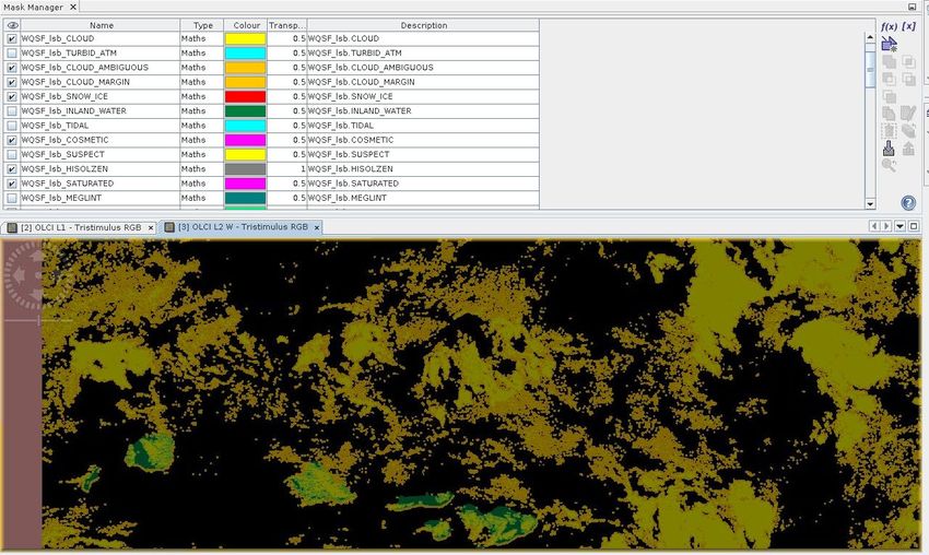
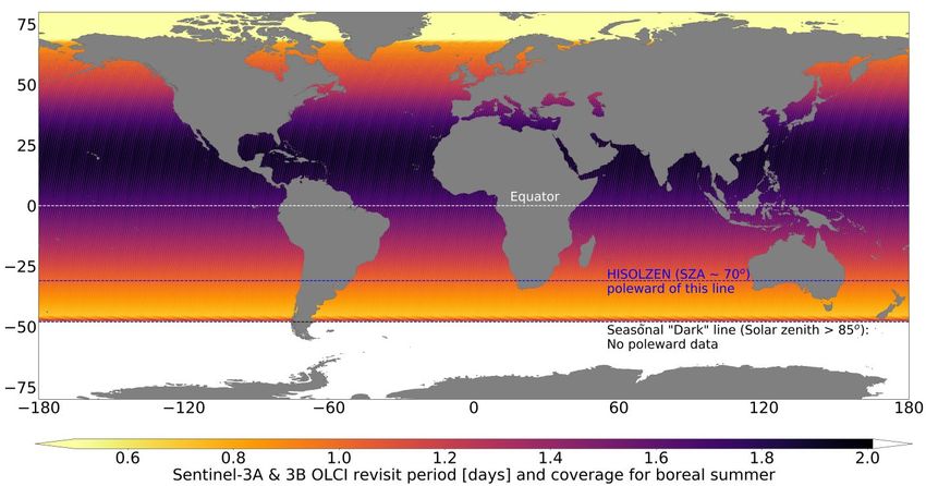
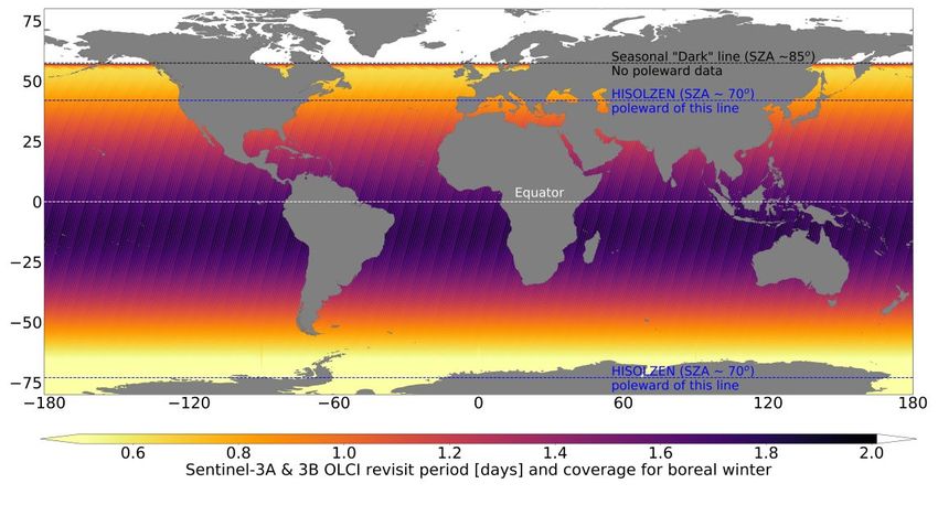
EUM/OPS-SEN3/MAN/17/907205
 v2G e-signed, 12 March 2021

 Sentinel-3 OLCI Marine User Handbook
 This Document is Public
4 OLCI: GEOPHYSICAL VARIABLES, INSTRUMENTS AND PRINCIPLE

4.1 Ocean colour coverage of all aquatic environments
Throughout this document, we refer to ‘ocean colour’. However, the reader should be aware
that OLCI provides products over all aquatic environments: the open ocean, seas, coastal zones
and inland waters. Unless information is specified as only relevant to a given domain (e.g. open
ocean only), then it should be considered as relevant to all.

4.2 Instrument coverage
The Sentinel-3 satellites are in a sun-synchronous orbit, completing 385 orbits (i.e. 770 pole-
to-pole tracks) in exactly 27 days. Sentinel-3B orbits 140o out of phase in advance of Sentinel-
3A to give a denser pattern of coverage. The mean global coverage revisit time for OLCI
observations is 1.9 days at the equator (one operational spacecraft) or 0.9 days (two satellites
in constellation) with these values increasing at higher latitudes, due to orbital convergence.
Due to changes in available light with season, OLCI’s coverage is periodically limited at high
latitudes, as shown in Figure 1 and Figure 2.

Figure 1: The average OLCI revisit time for two satellites during the boreal winter period, the 27-day cycle
centred on December 21st. Coverage has been masked for high glint, and zones where high solar zenith angle
are indicated. Note that, in boreal mid-winter, OLCI does not acquire data poleward of ~60°N due to prevailing
darkness at the overpass time.

 Page 17 of 48
EUM/OPS-SEN3/MAN/17/907205
 v2G e-signed, 12 March 2021

 Sentinel-3 OLCI Marine User Handbook
 This Document is Public

Figure 2: As in Figure 1, but for boreal summer, the 27-day cycle centred on June 21st. Note that, due to the
 orbital inclination of the Sentinel-3 satellites the winter and summer coverage maps are not symmetrical.

4.3 Ocean colour measurement principles
Ocean colour is the change in the colour of the ocean, and other water bodies such as seas and
lakes, due to the substances dissolved and particles suspended within the water. In the middle
of the open ocean the water tends to be blue in colour. Close to the coast, the water varies in
colour from blue to green, to brown and to white depending on what is present in it. By
numerically quantifying this change in colour, concentrations of in-water constituents can be
determined. Of major interest are phytoplankton, the microscopic algal plants in the ocean, as
well as suspended sediments and coloured dissolved organic matter.

Space sensors retrieve the spectral distribution of upwelling radiance just above the sea surface,
which is termed the water-leaving radiance (Lw). From the water-leaving radiance,
concentrations of in-water constituents and their inherent optical properties are derived.
However, the sensors actually measure the Top Of Atmosphere (TOA) radiance and so the
contribution resulting from the atmosphere’s scattering and absorption needs to be accounted
for through Atmospheric Correction (AC).

Atmospheric correction for ocean colour data is challenging [RD-1] as only about 10% of the
radiance measured by a satellite instrument in visible blue and green wavelengths originates
from the water and significantly less in the red. The sensors thus require very low radiometric
and spectral uncertainties and a high signal to noise ratio (SNR), particularly for the ‘blue’
bands (~ 400 nm). Ocean colour instrument design must therefore incorporate extremely
sensitive and stable radiometry, dedicated on-board calibration and spectral bands located at
wavelengths of specific interest, not only to quantify suspended phytoplankton and other
particles and substances in the water, but also to quantify the atmospheric constituents in order
to better correct for the atmospheric effects.

 Page 18 of 48
EUM/OPS-SEN3/MAN/17/907205
 v2G e-signed, 12 March 2021

 Sentinel-3 OLCI Marine User Handbook
 This Document is Public

Once corrected, the water-leaving radiance is normalized, , to approximate the Sun at
zenith, absence of the atmosphere, and a mean Sun-Earth distance (Morel and Gentili, 1996
[RD-2]):
 ( )
 ( ) = ( )
 (Eq. 1)

where is the total (i.e. direct plus diffuse, Rayleigh plus aerosol) downward transmittance
of the atmosphere, -the cosine of the solar zenith angle, and -a coefficient accounting for
the variation in the Sun-Earth distance. Conversion to remote-sensing reflectance and water
reflectance is expressed in Eqs 2 and 3, where 0 is the mean extraterrestrial solar spectral
irradiance. Water reflectance is also sometimes called water-leaving reflectance. The name
‘water reflectance’ will be used in the rest of this document.

 ( )
 ( ) = (Eq. 2)
 0( )

 ( ) ( )
 ( ) = or ( ) = (Eq. 3)
 0( ) ( ) 0( )

Note that both reflectances in Eq. 2 and 3 are not corrected for the Bidirectional Reflectance
Distribution Function (BRDF) (Morel et al., 2002 [RD-3]). These are directional reflectances
and are still dependent on their viewing direction, i.e. on the angular distribution of the
upwelling underwater radiance and on the transmittance through the sea surface from water to
air. Radiance or reflectance products from various missions are often corrected for the BRDF.
OLCI standard product is the directional water reflectance from Eq. 3, i.e. OLCI water
reflectance product is not corrected for the BRDF effect.

These radiometric products are then used to estimate geophysical parameters through the
application of specific bio-optical algorithms e.g. estimates of phytoplankton biomass through
determining the Chlorophyll-a (Chl) concentration. The Ocean Colour for MERIS (OC4Me)
Chl algorithm uses the irradiance reflectance (R) as the input [RD-4]:
 4 x

 log10 [Chl ] = ∑ ( Ax log10 R i
 j ) (Eq. 4)
 x =0

 A0 A1 A2 A3 A4
 0.4502748 −3.259491 3.522731 −3.359422 0.949586

 R ij = max ( 555
 443 490
 R, 555 510
 R, 555 R) (Eq. 5)

 ρw ( λ ) Q
 R (λ ) = (Eq. 6)
 πℜ
where Eq. 6 applies the BRDF correction with the Q factor being Chl-dependant, and ℜ is a
geometrical factor that encompasses the air-sea interface effects [RD-2]. OC4Me algorithm is
applied for OLCI for chlorophyll levels higher than 0.1 mg/m3.

 Page 19 of 48
EUM/OPS-SEN3/MAN/17/907205
 v2G e-signed, 12 March 2021

 Sentinel-3 OLCI Marine User Handbook
 This Document is Public
Chl is more difficult to quantify in complex waters, as opposed to open waters, due to a more
complex bio-optical signal. Clear waters in the open ocean, seas and some lakes have the
spectral signature dominated by phytoplankton pigments. On the other hand, complex waters
are significantly influenced by Coloured Dissolved Organic Matter (CDOM) [RD-5] and/or
suspended sediments (Total Suspended Matter, TSM) and phytoplankton and primarily occur
in coastal and inland zones. Therefore, OLCI has separate Open Water and Complex Water
approaches for deriving its ocean colour products. Open and Complex water classification has
been also called Case 1 and Case 2 water, respectively. [Table 4 in section 6.5 explains which
approaches are used to derive individual OLCI standard products, e.g. OC4Me chlorophyll-a
is developed for Open Waters and a neural network based approach (NN) for Complex Waters.]

4.4 OLCI instrument specifics
The key mission driver for the Sentinel-3 OLCI instrument is continuity of the Envisat MERIS
instrument capability [RD-7]. As such, it is a push-broom imaging spectrometer with 5 camera
modules sharing the Field Of View (FOV):
• The five cameras’ FOV are arranged in a fan-shaped configuration in the vertical plane
 perpendicular to the platform velocity,
• Each camera has an individual FOV of 14.2 degrees with a 0.6 degree overlap with its
 neighbours,
• Each camera is equipped with a CCD composed of 740 x 520 detectors, where 740 pixels
 correspond to the spatial extent of the camera FOV and 520 pixels to the decomposition of
 radiance into spectral components from 390 nm to 1040 nm,
• Five camera FOV is tilted westwards across-track by 12.58 degrees away from the Sun to
 minimise the Sun glint impact.

OLCI has the following significant improvements when compared to MERIS:
• An increase in the number of spectral bands (from 15 to 21),
• Improved SNR and a 14-bit analogue to digital converter (ADC),
• Improved coverage of global aquatic environments when there are 2 satellites (A & B): ~
 3 days ignoring the effect of clouds.
• A long time-series dataset, made by launching 4 missions (A to D) over 20+ years.
• Improved data delivery timeliness for L1B and L2 products, for NRT products being 3
 hours from the time of sensing,
• 100% overlap with SLSTR swath, and simultaneous acquisitions facilitating the use of
 OLCI and SLSTR in synergy.

The 21 wavelengths used to measure TOA radiance are as shown Table 1, alongside the SNR
for a reference radiance (Lref) that approximates the expected signal from an open-ocean water
pixel; see [RD-7] for the reference radiance values. The measured spectral response functions,
which described the true shape of the wavebands, are available for both Sentinel 3A and 3B.
These can be accessed via the link in the footnote of this page3.

The sampling period of the OLCI detectors (CCD’s) runs at 44 ms, which correspond to a mean
along-track distance of about 300 m. Therefore, OLCI produces the Full Resolution (FR)

3
 Link to the OLCI-A and OLCI-B Spectral Response Functions Document:
https://sentinel.esa.int/web/sentinel/technical-guides/sentinel-3-olci/olci-instrument/spectral-response-function-
data

 Page 20 of 48
EUM/OPS-SEN3/MAN/17/907205
 v2G e-signed, 12 March 2021

 Sentinel-3 OLCI Marine User Handbook
 This Document is Public
product with a spatial resolution of approximately 300 m. In addition, the Reduced Resolution
(RR) product is generated with a spatial resolution of approximately 1.2 km with 16 (nominally
four by four) FR pixels averaged to create a RR pixel; the number of pixels used is varied in
the across track direction, as a function of the across track pointing angle from the RR product
pixel centre, so that spatial resolution degradation is minimised at the FOV edges.

4.5 Calibration and validation activities
Sentinel-3 calibration and validation (Cal/Val) activities are essential to the quality of the
mission. Calibration determines the quantitative response of a system or measuring instrument,
to known and controlled inputs. The calibration of satellite instrument allows it to provide
reliable data to meet the mission requirements (AD-2) and the requirements of applications and
services.

In terms of the onboard calibration, OLCI is equipped with a calibration assembly, which
includes a motorized wheel with three fixed diffusers, a shutter, and an Earth View port that
allows the cameras free access to the Earth in imaging mode. Calibrations happen periodically,
mostly at the ecliptic South Pole where the sunlight can reach the exposed diffuser in the
calibration assembly [RD-15]. There are 3 Sun diffusers: 2 “white” diffusers dedicated to
radiometric calibration, and one doped with erbium dedicated to spectral calibration [RD-15].

In addition to instrument pre-launch and onboard calibrations, a System Vicarious Calibration
(SVC) must be applied to achieve the required ocean colour product uncertainties ([AD-2];
[RD-6]; [RD-16]).

SVC uses highly accurate in situ measurements of water-leaving radiances, which are the best
quality radiometric Fiducial Reference Measurements for ocean colour. SVC employs these
FRMs to reduce residual biases in Level-2 products. Details of the SVC process can be found
in [RD-17].

Validation is focused on independently assessing the accuracy and stability of the satellite
products. For ocean colour this involves inter-comparisons with high-quality ground-truth in
situ measurements (FRMs) of both the radiometry and bio-optical parameters and inter-
comparisons with corresponding products from other stable missions and climatologies. In
ocean colour, in situ FRMs provide critical knowledge of the ground truth but are sparse due
to the complexity of radiometric and bio-optical measurements from ships and instrumented
platforms. Mission inter-comparisons allow for large-scale global time-series evaluations.

To support validation, EUMETSAT and ESA have a permanently-open Announcement of
Opportunity call 4 "To engage world-class validation expertise and activities to complement
Sentinel-3 routine validation activities and ensure the best possible outcomes for the Sentinel-
3 Mission". Sentinel-3 Validation Team (S3VT) supports Agency product validation efforts
and receives privileged access to the Sentinel-3 OLCI data.

4
 S3VT main web page: https://nikal.eventsair.com/QuickEventWebsitePortal/sentinel-3-validation-team-
s3vt/esa

 Page 21 of 48
EUM/OPS-SEN3/MAN/17/907205
 v2G e-signed, 12 March 2021

 Sentinel-3 OLCI Marine User Handbook
 This Document is Public

 Table 1: OLCI wavebands; updated from [RD-7]
 Band Central Spectral SNR @ Lref for each of the 5 Function
 number wavelength width cameras *
 [nm] [nm]
 Oa1 400.000 15 2420/2396/2324/2369/2278 AC, improved water
 constituent retrieval
 Oa2 412.500 10 2398/2410/2341/2402/2387 CDOM and detrital pigments
 Oa3 442.500 10 2161/2200/2167/2186/2198 Chlorophyll-a (Chl-a)
 absorption maximum
 Oa4 490.000 10 2000/2035/1995/1982/1987 High Chll-a and other
 photosynthetic pigments
 Oa5 510.000 10 1979/2013/1982/1965/1984 Chl-a, TSM, turbidity and red
 tides
 Oa6 560.000 10 1776/1802/1801/1794/1818 Chl-a reference (minimum)
 Oa7 620.000 10 1591/1610/1625/1593/1615 TSM
 Oa8 665.000 10 1547/1559/1566/1533/1560 Chl-a (2nd absorption
 maximum), TSM and CDOM
 Oa9 673.750 7.5 1329/1338/1350/1324/1341 Improved fluorescence
 retrieval
 Oa10 681.250 7.5 1320/1327/1338/1314/1332 Chl-a fluorescence peak
 Oa11 708.750 10 1420/1421/1434/1413/1429 Chl-a fluorescence baseline
 Oa12 753.750 7.5 1127/1120/1133/1124/1138 O2 (oxygen) absorption and
 clouds
 Oa13 761.250 2.5 502/498/505/500/507 O2 absorption band and AC
 aerosol estimation
 Oa14 764.375 3.75 663/658/667/661/669 AC
 Oa15 767.500 2.5 558/554/562/556/564 O2 A-band absorption band
 used for cloud top pressure
 Oa16 778.750 15 1514/1496/1523/1509/1524 AC aerosol estimation
 Oa17 865.000 20 1243/1213/1238/1245/1250 AC aerosol estimation,
 clouds and pixel co-
 registration, in common with
 SLSTR
 Oa18 885.000 10 823/801/814/824/831 Water vapour absorption
 reference band
 Oa19 900.000 10 691/674/683/693/698 Water vapour absorption
 Oa20 940.000 20 535/523/525/539/542 Water vapour absorption,
 linked to AC
 Oa21 1020.000 40 346/338/349/346/351 AC aerosol estimation

*
 Data supplied by Donlon (pers. comm.), correct as of June 2017 for Sentinel-3A

 Page 22 of 48
EUM/OPS-SEN3/MAN/17/907205
 v2G e-signed, 12 March 2021

 Sentinel-3 OLCI Marine User Handbook
 This Document is Public
4.6 Where to go for further information on the algorithms
The detail of each algorithm is written within an Algorithm Theoretical Basis Document
(ATBD), which is publicly accessible 5. A list of the ATBD documents is provided in Table 2.

 Table 2: OLCI ocean colour product primarily ATBDs

 Product ATBD ATBD Reference

 Baseline AC: Atmospheric correction over S3-L2-SD-03-C07-LOV-ATBD &
 Oa##_reflectance, Open Waters with integrated OLCI Bright EUM/OPS-
 A865 & T865 Pixel Correction (BPC) SEN3/DOC/17/961973(MERIS
 ATBD 2)

 PAR Instantaneous Photosynthetically Active S3-L2-SD-03-C12-ARG-ATBD
 Radiation

 CHL_OC4ME & Ocean Colour Products in Open Water S3-L2-SD-03- C10-LOV-ATBD
 KD490_M07

 ADG443_NN, Alternative AC: Atmospheric correction over S3-L2-SD-03-C17-GKSS-ATBD
 CHL_NN & Complex Waters, based on Neural Network
 TSM_NN regression

 Ocean Colour Complex Water S3-L2-SD-03-C11-GKSS-ATBD

 IWV Integrated Water Vapour column Lindstrot et al., 2012 [RD-14]

5
 EUMETSAT’s ocean colour webpage: https://www.eumetsat.int/ocean-colour-services,
https://www.eumetsat.int/ocean-colour-resources

 Page 23 of 48
EUM/OPS-SEN3/MAN/17/907205
 v2G e-signed, 12 March 2021

 Sentinel-3 OLCI Marine User Handbook
 This Document is Public
5 PROCESSING LEVELS AND SCHEMES

The OLCI operational processor comprises three major processing levels:

 • Level 0
 This step processes raw data contained in instrument source packets. Level 0 products
 are internal products, and are not disseminated to users.

 • Level 1
 This step processes the Level 0 data to geo-located and calibrated top of atmosphere
 radiances for each OLCI band.

 • Level 2
 This step processes the Level 1 data to water leaving reflectances and bio-optical
 variables (e.g. chlorophyll).

5.1 Level-1 processing approach
The OLCI L1B processor has 3 modes, each of which produce their own L1B products. The
radiometric and spectral calibration modes process OLCI calibration data which are used off-
line to develop instrument radiometric and spectral models that are stored in dedicated look up
tables. The Earth observation mode produces L1B calibrated and geolocated products at the
full and reduced spatial resolution. The main data processing steps taken to produce Earth
observation L1B products [RD-20] are:
• Data extraction and quality checks
• Radiometric Calibration
 o Primary instrument corrections and radiometric scaling
 o Stray light correction
• Geo-referencing
• Pixel classification
• Spatial re-sampling
• Annotations
• Products formatting

The OLCI Radiometric Model is based on the continuous set of in-flight radiometric
calibrations. It includes radiometric gain coefficients at a reference date and a long-term
evolution model. From 05/07/2017 and 29/10/19 onwards for OLCI-A and OLCI-B,
respectively, and for reprocessed data, the set of radiometric gain coefficients used to derive
both the Reference Gains and the Evolution Model have been computed using up-to-date
geometric and spectral calibrations and instrument settings and the upgraded diffuser BRDF
model based on in-flight data as well as diffuser ageing (browning) correction. The
Radiometric Model is continuously monitored against new Radiometric Calibration
acquisitions and updated calibration is used in the processing. More details can be found in the
OLCI product notices6.

6
 https://www.eumetsat.int/ocean-colour-services

 Page 24 of 48
EUM/OPS-SEN3/MAN/17/907205
 v2G e-signed, 12 March 2021

 Sentinel-3 OLCI Marine User Handbook
 This Document is Public

5.2 Level-2 processing approach
OLCI L2 processing flow is illustrated in Figure 1. Auxiliary data and parametrization of the
processor are available in Auxiliary Data Files (ADFs) [RD-32].

Level-2 pre-processing includes pixel classification, gaseous correction, computation of the
Integrated Water Vapour product (IWV), alongside the smile correction, adjustments for white
caps and sun glint, and application of System Vicarious Calibration gains. Then, the default
operation is that two atmospheric correction (AC) approaches are run in parallel: the Baseline
Atmospheric Correction (BAC) and the Alternative Atmospheric Correction (AAC). The BAC
feeds the majority of further ocean colour steps and products, denoted here as Open Water
products. The AAC feeds the NN Case 2 Regional / Coast Colour (C2RCC) processing and
outputs three Complex Water products.

The Baseline AC (BAC) algorithm is based on the algorithm developed for MERIS (Antoine
and Morel, 1999 [RD-8]), to ensure consistency between the two instruments' records. BAC
was designed for Open Waters, with a spectral signature dominated by phytoplankton
pigments. The Bright Pixel Correction (BPC) integrated with BAC allows adaptation of the
processing to more complex waters (Moore et. al. 1999 [RD-9] and Moore et al., 2017 [RD-
10]). The BPC accounts for situations where the Near Infrared (NIR) water-leaving radiance is
not negligible i.e., high scattering waters where there is a high Chl and/or TSM concentration.
The version implemented in the OLCI processing chain is an update of the Moore et. al. 1999
[RD-9] paper, with improvements to the OLCI ATBD [RD-10] resulting from the 4th
reprocessing of the MERIS data. Further improvements have been made as part of the
OL_L2M.003 collection (see [RD-24] and references within). The OLCI algorithm uses a
coupled atmosphere-hydrological model where the water contribution is implemented in terms
of Inherent Optical Properties (IOPs). The model is solved using spectral optimization
inversion at six NIR bands.

The output of the BAC processing is the water reflectance (see Eq. 3) alongside the aerosol
optical depth (T865) and Ångström exponent (A865) that are calculated as part of the BAC
process, and indicate the AC’s success in subtracting the atmospheric contribution. If the BAC
is working correctly then the atmospheric by-products should not show contamination from
marine features.

The Photosynthetically Active Radiation (PAR) product, inherited from MERIS, is the
instantaneous PAR at the water surface. It was originally developed for Sun-stimulated
fluorescence calculations (Aiken and Moore, 1997 [RD-11]).

The following bio-optical products, primarily applicable in Open Waters, are then calculated
from water reflectance:

Algal pigment concentration based on the Ocean Colour for MERIS (OC4Me) algorithm
developed by Morel et al. (2007 [RD-12]), following the approach of O'Reilly et al. (1998 [RD-
22]), with the product called CHL_OC4ME. To complement the OC4Me algorithm, a
chlorophyll index (CI) approach was developed for Collection OL_L2M.003 for application
specifically in low-chlorophyll oligotrophic waters [RD-25]. The CI implementation is in
response to S3 OLCI/SYN QWG and S3VT-OC recommendations. The CI methodology
follows Hu et al. (2012) [RD-26], and the switching between CI and OC4Me (i.e. low and
higher chlorophyll concentrations) follows Wang and Son (2016) [RD-27]. The CI algorithm

 Page 25 of 48
You can also read