Waimakariri Residential Red Zone Recovery Plan - He Mahere Whakarauora i te Whenua Rāhui o Waimakariri
←
→
Page content transcription
If your browser does not render page correctly, please read the page content below
Waimakariri Residential
Red Zone Recovery Plan
He Mahere Whakarauora i te
Whenua Rāhui o Waimakariri

December 2016
Ka
                                      iapo
                                             i R
                                                 ive
                                                      r
                                                      r
                                                  ive
                                               iRir
                                              ar
                                           ak
                                     aim
                                    W

Cover photography by Tony Bridge
Regeneration areas
and their land uses
KEY

      Mixed use business             Recreation and ecological linkage         Stormwater management

      Sport and recreation reserve   Heritage and mahinga kai                  Existing reserve

      Dudley Drain                   Private lease                             Private property

      Memorial garden                Tūhaitara Coastal Park                    Regeneration area

      Rural                          Utility                             Boundaries within regeneration
                                                                         areas are approximate only
Published in December 2016 by
Greater Christchurch Group
Department of the Prime Minister and Cabinet
Christchurch, New Zealand

Contact
Greater Christchurch Group
Department of the Prime Minister and Cabinet
Private Bag 4999, Christchurch 8140
infogcg@dpmc.govt.nz
(03) 903 0593
www.dpmc.govt.nz/gcg

ISBN
978-0-947520-00-7 (Print)
978-0-947520-01-4 (Online)

Crown copyright
This work is licensed under the Creative Commons Attribution 4.0 International
Licence. You are free to copy, distribute, and adapt the work, as long as you attribute
the work to the Greater Christchurch Group, Department of the Prime Minister
and Cabinet and abide by the other licence terms. To view a copy of this licence,
visit https://creativecommons.org/licenses/by/4.0/. Please note you may not use
any departmental or governmental emblem, logo, or coat of arms in any way that
infringes any provision of the Flags, Emblems, and Names Protection Act 1981. Use
the wording 'Greater Christchurch Group, Department of the Prime Minister and
Cabinet' in your attribution, and not by reproduction of any such emblem, logo or
coat of arms.
Contents
Ngā Ihirangi

Ministerial Foreword He Kupu Whakataki a Te Minita                              2

Executive Summary Te Whakarāpopototanga Matua                                   3

1. Background He Kōrero Taunaki                                                 4

  1.1 What is the purpose of this Recovery Plan?                                4

  1.2 How was this Recovery Plan developed?                                     5

  1.3 What were the overall issues and considerations?                          8

  1.4 What is in this Recovery Plan?                                            8

2. Kaiapoi West Regeneration Area Whakarauora i te Takiwā Uru o Kaiapoi         9

3. Kaiapoi South Regeneration Area Whakarauora i te Takiwā Tonga o Kaiapoi     12

4. Kaiapoi East Regeneration Area Whakarauora i te Takiwā Rāwhiti o Kaiapoi    16
                                                                                       .
5. The Pines Beach Regeneration Area Whakarauora i te Takiwā o Tātahi Paina   20

6. Kairaki Regeneration Area Whakarauora i te Takiwā o Kairaki                23

7. Next Steps – How will this Recovery Plan be put into action?               26
   He Mahi Hei Whai Ake-Te Whakatinanatanga o te Mahere Whakarauora

  7.1 Implementation                                                           26
  7.2 Financial implications                                                   27
  7.3 Monitoring                                                               27

8. Links to Further Information He Hononga Mōhiohio                           28

Glossary of Terms and Abbreviations He Rārangi Kupu me Ngā Whakapotonga       29

                                                                              PAGE 1
Ministerial Foreword
      He Kupu Whakataki a Te Minita

                           I am pleased to present the              I commend the Waimakariri District Council on the
                           Waimakariri Residential Red              significant amount of consultation undertaken in
                           Zone Recovery Plan, which I have         developing the Recovery Plan to ensure the community
                           approved under the Canterbury            and stakeholders’ views have been heard and reflected.
                           Earthquake Recovery Act 2011.            By using a variety of engagement methods, including
                           This marks an important milestone        the interactive 3D model of the areas, public meetings
                           in the recovery and regeneration of      and a public hearing, the Council has helped to ensure a
                           the Waimakariri district and greater     wide cross-section of people have had an opportunity to
                           Christchurch following the               provide their views on the future use of the residential red
                           2010-2011 Canterbury earthquakes.        zones in Waimakariri.

      In deciding to approve the Recovery Plan, I considered        This is an exciting step forward. Together with the
      the Draft Recovery Plan and supporting information            Waimakariri District Council and greater Christchurch
      provided to me by the Waimakariri District Council on         communities, I look forward to the next phase of the
      1 August 2016. I also took into account the written           regeneration for the Waimakariri district. It has been a
      comments received during the final round of public            long journey, and getting to this point has been achieved
      engagement in the Recovery Plan process, which                through everyone providing input and committing to
      took place over four weeks from 3 August to                   make a better place for current and future generations.
      1 September 2016.

      I am satisfied that the agreed land uses set out in this
.     Recovery Plan for residential red zone land in Kaiapoi,
      Kairaki and The Pines Beach represent a good balance of
      multiple recovery and regeneration objectives, including
      those set out in legislation; my direction to the Council;    Hon Gerry Brownlee
      the Council’s Vision and Goals in the Draft Recovery Plan;
      and the needs and aspirations of the community.               Minister supporting Greater
                                                                    Christchurch Regeneration
      The Crown has agreed in principle to divest residential
      red zone land as required to achieve these agreed land
      uses. In addition to the significant expenditure the Crown,
      on behalf of New Zealand taxpayers, made through the
      Crown offer process, this divestment underlines the
      Crown’s ongoing commitment to a strong and resilient
      greater Christchurch.

    PAGE 2
Executive Summary
Te Whakarāpopototanga Matua

The 2010-2011 Canterbury earthquakes caused                    •   mixed use business – 9 hectares, including
unprecedented and widespread damage to greater                     commercial and retail activities, car parking and/or a
Christchurch. In Kaiapoi, The Pines Beach and Kairaki,             motor caravan park;
about 100 hectares – over a fifth of the total residential     •   rural – 30 hectares, likely to include cropping and
area – were classified as ‘residential red zone’. This             grazing, but excluding intensive farming; and
was part of the Crown’s emergency social policy
                                                               •   private lease – 2 hectares of open space/non-
response to the earthquakes and the urgent need to
                                                                   permanent/flood tolerant activities, potentially
assist people in the worst affected areas. This has had
                                                                   including boat storage, tennis courts and/or
a profound impact on the communities, businesses,
                                                                   car parking.
infrastructure and environment of Kaiapoi and its
surrounding areas.                                             This package of agreed land uses best meets the
                                                               Crown’s recovery and regeneration objectives, including
The Waimakariri District Council (the Council) was             the purposes set out in the Canterbury Earthquake
directed by the Minister supporting Greater Christchurch       Recovery Act 2011 (CER Act) and the Greater Christchurch
Regeneration (the Minister) to prepare a Draft Recovery        Regeneration Act 2016 (GCR Act), along with the
Plan to identify the long-term uses for the five residential   objectives set out in the Minister’s direction to develop a
red zone areas in the district (referred to as ‘regeneration   Draft Recovery Plan, and public input provided throughout
areas’ in this Recovery Plan). The Council presented the       the Recovery Plan process.
Minister with the Draft Recovery Plan on 1 August 2016.
The Minister notified the Draft Recovery Plan for written      The agreed land uses take into account the Crown’s
comments from 3 August to 1 September 2016. He has             Treaty of Waitangi obligations, including as required
considered the written comments received, along with           under the Ngāi Tahu Claims Settlement Act 1998. The
various technical information and analysis, in making his      land uses also consider the Crown’s obligations to
decision on the Recovery Plan.                                 greater Christchurch and New Zealand taxpayers, as
                                                               well as the current and future needs of the communities
This Recovery Plan sets out the agreed long-term uses          in the Waimakariri district – while recognising there are
for the five regeneration areas to facilitate recovery from    multiple and competing considerations that affect land           .
the impacts of the Canterbury earthquakes and support          use options.
regeneration. The Recovery Plan reflects the need to
balance certainty of outcomes for the community while          The Crown has agreed in principle to divest the majority
allowing flexibility for long-term implementation and          of Crown-owned land in the five regeneration areas to
management of the agreed land uses.                            the Council, with the rest (parts of The Pines Beach and
                                                               Kairaki regeneration areas) to be divested to Te Kōhaka
Chapter 8 provides links to further information and key        o Tūhaitara Trust (the Trust). This puts the Council in the
documents, including a report outlining the Minister’s         driving seat; recognises these parties are best placed
decision to approve the Recovery Plan and the                  to manage the land and implement the land uses in a
amendments made to the Draft Recovery Plan.                    coordinated and cost-effective way; and underlines the
                                                               Crown’s commitment to locally led regeneration.
The land uses in this Recovery Plan are based on
available information about relevant factors and               Land will be divested with conditions ensuring the
considerations, including: geotechnical constraints;           agreed land uses will be implemented, and that financial
natural hazards; market demand; Council resourcing;            return is maximised wherever possible, with the Crown to
and demographic changes. In summary, the agreed land           receive a share of any future net financial returns
uses are:                                                      (where applicable).
•   greenspace – 41 hectares, with various uses                Implementation of the Recovery Plan will span at least
    including sports fields, parks, a heritage and mahinga     the next 30 years, involving multiple parties and further
    kai area, managing the land as part of the existing        community consultation. A first step will be for the Crown
    Tūhaitara Coastal Park, a memorial garden, BMX             to divest land to the Council and the Trust, with the
    track and/or dog park;                                     Council’s lead role in implementation expected to begin
                                                               in early 2017.

                                                                                                                       PAGE 3
1. Background
      He Kōrero Taunaki

           What is the purpose of this                            The Minister’s direction notes that decisions about the
       1.1                                                        Waimakariri residential red zones should reflect the
           Recovery Plan?                                         following objectives:

      The Minister’s direction sets out the purpose, objectives
      and scope of this Recovery Plan. The purpose is:
                                                                       1.   Promote the wellbeing of greater
                                                                            Christchurch communities.
         "To identify the intended long-term uses of the
         residential red zone in Waimakariri to facilitate             2.   Result in outcomes that are resilient
         recovery from the impacts of the Canterbury                        and enduring.
         earthquakes…
                                                                       3.   Support economic development
         The Recovery Plan will identify the practical next                 and growth.
         steps for the implementation of the Recovery
         Plan, including how ownership, funding,                       4.   Be affordable and consistent with the
         and management of different areas will be                          government’s commitment to principles of
         determined in future."                                             responsible fiscal management.

.

          Photography by Ann Worthy

    PAGE 4
1. Background He Kōrero Taunaki

          How was this Recovery
 1.2                                                         4.    Ensuring land use proposals are resilient and
          Plan developed?                                          built for the future drawing on relevant, sound
                                                                   assessment of and prudent response to the
Following the Minister’s direction in September 2015               risks posed by natural hazards.
and the earlier Canvas public engagement process in
2014, two rounds of public engagement were carried           5.    Enabling opportunities to restore the natural
out on the “Let’s Discuss” discussion document and the             environment to support biodiversity as well as
Preliminary Draft Recovery Plan in October 2015 and                economic prosperity.
February/March 2016 respectively. A public hearing was       6.    Recognising and enhancing Ngāi Tūāhuriri and
held in April 2016 that considered the feedback on the             Ngāi Tahu values, aspirations and the important
Preliminary Draft Recovery Plan.                                   cultural history of the area.

In developing the Draft Recovery Plan the Council
considered a range of technical reports covering
                                                           The Council submitted the Draft Recovery Plan to the
geotechnical and flooding hazards, potential land
                                                           Minister on 1 August 2016 and the Minister publicly notified
remediation costs, market analyses of different land use
                                                           the Draft Recovery Plan for written comment from 3 August
options, and relevant planning considerations.
                                                           until 1 September 2016.
The Council’s Vision and Goals for regeneration guided
                                                           Sixty written comments were received: 23 via comment
the development of the Draft Recovery Plan. In summary,
                                                           forms, email or post, and 37 from the Greater Christchurch
these were:
                                                           Regeneration Facebook page. Overall, there was broad
                                                           support for the land use proposals in the Draft Recovery
                                                           Plan. A link to the summary of written comments can be
    The Council's Vision
                                                           found in Chapter 8.
    Creatively and cost-effectively returning
    regeneration areas to active use, towards
    ensuring that Kaiapoi, Kairaki, The Pines
    Beach and the wider district are economically                                                                             .
    and socially vibrant, resilient, rewarding and
    exciting places for residents and visitors, while
    celebrating the significant cultural values of iwi
    and the wider community.

   The Council’s Goals
   1.   Returning the regeneration areas to active use
        in a timely, efficient and economic manner,
        reflecting the needs and aspirations of the
        Waimakariri community.

   2.   Significantly enabling Kaiapoi’s journey
        towards becoming a prosperous and
        innovative centre to live, work and play in.

   3.   Providing a safe, inspiring and attractive
        environment for residents and visitors, of all
        ages and abilities, with public access to and
        opportunities for active sport and recreation,
        cultural, social and economic activities.
                                                               Photography by Ann Worthy

                                                                                                                     PAGE 5
1. Background He Kōrero Taunaki

      In approving the Recovery Plan, the Minister has            Te Rūnanga o Ngāi Tahu is both a Treaty partner with the
      considered the written comments, and the requirements       Crown and a strategic partner with the Crown, Environment
      of the CER Act and GCR Act, along with the information      Canterbury and the Council under the GCR Act.
      provided by the Council and other stakeholders.             Te Rūnanga o Ngāi Tahu has been involved in this
                                                                  Recovery Plan alongside Te Ngāi Tūāhuriri Rūnanga, the
                                                                  mandated representative of Ngāi Tūāhuriri, the mana
      Planning and legal framework                                whenua of this takiwā.
      The land uses have been considered and assessed
      against relevant key planning documents, including:         The values of mana whenua, Ngāi Tūāhuriri and Ngāi
                                                                  Tahu and their perspectives on the future of the five
                                                                  regeneration areas have been important considerations in
      •   The Recovery Strategy for Greater Christchurch:
                                                                  developing this Recovery Plan, including ensuring that:
          Mahere Haumanutanga o Waitaha
      •   The New Zealand Coastal Policy Statement 2010           •   decision making reflects the aspirations of Ngāi
                                                                      Tūāhuriri and Ngāi Tahu;
      •   The Canterbury Regional Policy Statement 2013
                                                                  •   the cultural presence of Ngāi Tūāhuriri and Ngāi Tahu
      •   The Waimakariri District Plan
                                                                      is visible and enhanced; and
      •   The Mahaanui Iwi Management Plan 2013
                                                                  •   shared cultural and natural heritage is respected.
      •   The Waimakariri District Long Term Plan 2015–2025

      Any decisions on resource consents, notices of
      requirement, or changes to planning documents under the
      Resource Management Act 1991, must not be inconsistent
      with this Recovery Plan. Relevant instruments under the
      Local Government Act 2002 and Reserves Act 1977,
      including annual plans, long term plans and reserve
      management plans, also must not be inconsistent with
.     this Recovery Plan.

      Ngāi Tūāhuriri and Ngāi Tahu
      In preparing this Recovery Plan consideration has
      been given to the Crown’s existing Treaty of Waitangi
      obligations, including as required under the Ngāi
      Tahu Claims Settlement Act 1998. Any proposed land
      divestment in this Recovery Plan will be subject to
      those obligations.

      Consideration has also been given to the obligations in
      the Recovery Strategy. This is particularly relevant for
      land in or near regeneration areas which is of historical
      or cultural significance. For example, former Māori
      Reserve 877, Kaikanui, is adjacent to the Kaiapoi South         Photography by Ann Worthy

      regeneration area.

    PAGE 6
1. Background He Kōrero Taunaki
Land use assessment criteria
To assess potential land uses in the five regeneration and Goals; the Council’s Long Term Plan; and relevant
areas, the Council used criteria to capture and balance the statutory planning documents.
key considerations and to compare alternative land use
scenarios (see below). The Council considered and assessed different land
use scenarios for the five regeneration areas as a whole
These criteria reflect in particular: the objectives and against these criteria. The agreed land uses in this
obligations in the Minister’s direction; the Recovery Recovery Plan best meet these criteria.
Strategy; the CER Act; the GCR Act; the Council’s Vision
Best balance of regeneration objectives Optimises value for money
Social - including supporting community wellbeing Considers whole-of-life costs - affordable now
and in the future
Cultural - including reflecting iwi values,
aspirations and history; celebrating heritage values Considers the possibility of financial return for
the Crown
Economic - including supporting sustainable
business and employment growth Is fiscally responsible - does not expose the
Council or the Crown to financial risk
Environmental - including restoring and
enhancing the natural environment Is economically viable - considers potential
market demand
Land Use
Assessment
Criteria
Practicality Resilience .
Supports a pragmatic, timely approach Balances current and future needs of the
to regeneration district and greater Christchurch
Considers land damage, land conditions and Takes into account natural hazards and
feasibility of remediation and flood mitigation future events
Considers the impact on the current and future Integrates with surrounding areas and uses,
land owners including infrastructure requirements
Has an efficient implementation and Reflects and promotes community and
management model stakeholder buy-in
Land use assessment criteria
PAGE 71. Background He Kōrero Taunaki
What were the overall Further details on the overarching and area specific
1.3 issues can be found in the Draft Recovery Plan and
issues and considerations? supporting technical information (see Chapter 8 for links
to key documents).
The overarching issues and land use considerations
which are relevant to the five regeneration areas in Specific consideration has been given to the 33 private
Kaiapoi, Kairaki and The Pines Beach include: residential properties in the five regeneration areas in
determining the agreed land uses. The Recovery Plan does
not direct any District Plan amendments for these private
Social properties. However, the owners may request that their
property be included in any zoning amendments.
• Wellbeing of residents within and
surrounding the regeneration areas
• A range of community aspirations
about land uses and activities
What is in this
• Future population growth in the district 1.4
in the medium term Recovery Plan?
The next five chapters explore the relevant
Economic considerations for each regeneration area, and set out
the Minister’s decisions on land uses in those areas.
• Cost of remediating land Chapter 7 sets out the next steps, including how this
• Importance of Kaiapoi town centre Recovery Plan will be implemented and monitored.
• Funding sources
What are the timeframes?
• Projected increased demand for
commercial and industrial land in Kaiapoi The timeframes for implementation of the Recovery Plan
(medium to long term) and each of the land uses are set out in the next chapters.
.
The Recovery Plan is far reaching in scope and vision,
covering the next 30 years and beyond, and involving
Cultural multiple parties and ongoing community consultation.
Following gazettal of the Recovery Plan, actions are
• Areas of cultural significance to Ngāi defined as:
Tūāhuriri and Ngāi Tahu
• Short term – within two years
• Identified heritage values
• Medium term – two to ten years
• Ngāi Tahu Claims Settlement Act 1998,
where applicable • Long term – more than ten years
• Longer term – more than 30 years
Environmental Where can further information be found?
• Natural hazards Chapter 8 provides links to further information and key
• Opportunities to enhance the natural documents, and the glossary provides definitions of terms
environment and abbreviations used throughout the Recovery Plan,
including Tikanga Māori concepts.
• Temporary effect of remediating areas
on properties nearby
• Contaminated soil due to historic
land uses
PAGE 82. Kaiapoi West
Regeneration Area
Whakarauora i te Takiwā Uru o Kaiapoi
Kaiapoi West is the smallest regeneration area in Waimakariri (about 2.6 hectares). It includes one private
property as well as existing infrastructure, including Dudley Drain and a wastewater pump station. This
area is susceptible to flooding and land damage. Surrounding land uses which have been taken into
account include the adjacent Kaiapoi town centre, residential areas, Kaiapoi Borough Primary School and
Murphy Park. The area is currently zoned for residential use. Taking these factors into consideration, and
reflecting the land use assessment criteria and written comments, the agreed land uses for the Kaiapoi West
regeneration area include mixed use business in the southern half and greenspace in the northern half.
KAIAPOI WEST REGENERATION AREA
Ra
ve
nQ
ua
y
St
ch
Ri
MURPHY .
PARK
KEY
Regeneration area
t
ckS Mixed use business
l a
B
Sport and recreation reserve
Dudley Drain
Hi
Utility
lto
nS
Fu
Existing reserve
i St
t
lle
r
k
St
Pera
Private property
Boundaries within regeneration
areas are approximate only
PAGE 9KEY
Regeneration Area
Ra
ve
nQ
Business
ua
y
District Sport and
St
Recreation Reserve
ch
Ri
Dudley Drain
MURPHY
PARK
2. Kaiapoi West Regeneration Area Whakarauora i te Takiwā Uru o Kaiapoi
k St
ac
Bl
Hi
lto
n St
Fu
St
lle
r St
Peraki
existing business activities in Kaiapoi town centre and
address natural hazards.
Agreed land uses
These land uses reflect the majority of written comments
Greenspace (sport and recreation reserve) on the Draft Recovery Plan, which expressed broad
support for greenspace, including explicitly in this area.
Greenspace (Dudley Drain) Mixed use business was also broadly supported by public
Mixed use business comments, although some noted opposition to yard-based
retail activities.
These land uses take into account and balance the
land use assessment criteria including: the Crown The Crown has agreed in principle to divest Crown-owned
and Council’s regeneration objectives; optimising land in this regeneration area to the Council to implement
value for money now and in the future; practicality; these land uses. Land will be divested with conditions
and resilience. ensuring the agreed land uses will be implemented, and
that financial return is maximised wherever possible, with
the Crown to receive a share of any future net financial
Kaiapoi West’s location in relation to Kaiapoi town returns (where applicable).
centre and existing reserves, along with the restrictive
characteristics of the land, make greenspace and mixed
use business an appropriate combination of land uses for
the area.
Greenspace land used for a sport and recreation reserve
will integrate well with the neighbouring Murphy Park and
adjoining Kaiapoi River areas. It will provide additional
active and passive recreation opportunities for the
community in an accessible location near the town centre,
support community health and wellbeing, and enhance
. community cohesion. This land could be used for a lawn-
based sports club, a playground, an area for informal ball
play, paths, seating and planting, and overflow parking.
These land uses recognise the constraints imposed by the
flooding hazards identified in this area.
Greenspace land use will also allow the Council to upgrade
and enhance the existing Dudley Drain by widening the
drain for improved drainage performance, and will provide
native landscape planting opportunities to help improve
water quality and enhance the environment.
Mixed use business in Kaiapoi West recognises the area’s
proximity to the Kaiapoi town centre. Analysis of future
market demand, including identified future business and
public car parking needs in the town centre, means that
mixed use business activities will be economically viable
and appropriate in this regeneration area. This land use
will allow a range of activities, which could include
commercial and retail opportunities, and/or public
car parking. Mixed use business is compatible with
surrounding areas, including the adjoining residential area
and school. Business activities will need to complement Photography by Dylan Hunt
PAGE 10Ra
ve
nQ
ua
y
St
ch
Ri
MURPHY
PARK
2. Kaiapoi West Regeneration Area Whakarauora i te Takiwā Uru o Kaiapoi
k St
ac
Bl
Hi
lto
n St
Fu
St
lle
r St
Peraki
Kaiapoi West: Key actions to implement agreed land uses
General
• In early 2017 the Crown, working with the Council, develops an implementation framework setting out
joint objectives and actions, and clarifying roles and responsibilities for the different parties.
• Once the implementation framework is in place, the Council develops an implementation plan
for its agreed actions, detailing how it will ensure the agreed land uses in this Recovery Plan will
be implemented and within the specified timeframes. The Crown will assist in developing the
implementation plan, including by providing information about divestment of Crown-owned land and any
other Crown actions.
• In the short term, the Crown begins any road stopping using the process in the GCR Act.
• In the short term, the Council determines the most appropriate District Plan provisions and uses section
61(3) of the GCR Act to amend or vary the District Plan to give effect to the land uses for Kaiapoi West.
The Minister will determine the appropriate public process required to give effect to the proposed
amendments or variations.
Greenspace (sport and recreation reserve)
• In the short term, the Crown divests the land to the Council, and the Council declares the area vested
as a reserve. The Council develops and consults on a reserve masterplan for this land and the adjacent
Murphy Park Reserve and prepares concept plans, detailed design work and costings.
• In the medium term, the Council undertakes the staged construction of any physical works required
(for example, earthworks, sports areas and associated infrastructure, walking and/or cycling trails,
landscaping work).
.
Mixed use business
• In the short term, the Crown divests the land to the Council.
• In the short to medium term, the Council works with third parties as appropriate to determine the best
mixed business uses, including whether the land could be leased or sold to third parties for commercial
and/or retail developments and public car parking.
Greenspace (Dudley Drain)
• In the short term, the Crown divests the wastewater pump station land and Dudley Drain area to
the Council.
• In the medium term, the Council prepares a concept plan, detailed design and costings, and undertakes
construction of the enhanced Dudley Drain.
PAGE 113. Kaiapoi South
Regeneration Area
Whakarauora i te Takiwā Tonga o Kaiapoi
The Kaiapoi South regeneration area covers about 28.5 hectares. Three private properties are located here.
Characteristics of the land which have been considered in determining appropriate future land uses include
susceptibility to flooding and land damage. Surrounding land uses which have been taken into account
include Kaiapoi town centre, residential activities, and proximity to Courtenay Stream and Kaiapoi River.
Kaiapoi South also contains areas of cultural significance and is adjacent to Kaikanui, former Māori Reserve
877, historically an outpost of the Kaiapoi Pā. The area is currently zoned predominantly residential, with a
small pocket zoned rural.
Taking these factors into consideration, and balancing the land use assessment criteria and written
comments, the agreed land uses for the Kaiapoi South regeneration area include mixed use business
adjacent to the existing town centre; greenspace for heritage and mahinga kai adjacent to Kaiapoi River;
rural uses for over half the regeneration area; and recreation and ecological linkages.
KAIAPOI SOUTH REGENERATION AREA
y vale
t
on Ln
sS
err
ne
To
Jo
Ch
m
Cooks
ye
A
rs
D r
Ca
ss
St
Ch
t
a
S
rle
ick
sS
sw
t
Be
Ra
ve
n
Q
ua
Se
we
y
ll S
t
H
ilto
n
t
St
ie S
Joll
KA Ch
IA arle
.
PO sS
Ra IR t
ve
t
IV
rS
nQ ER
wle
ua CORCORAN
Bo
y RESERVE
C
Ln
ou
rte
on
na
rd
yD
Go
l
r
sP
la
KA
ug
IARP
Dawson Do
aOvI
eRn
IQ
VEu
aRyB
C
ou
ANK
r te
S
na
y
Dr
t
sS
ter
ar
Ch
Oho
ka R
KEY
r
yD
d
na
t
ers S
urte
Chart
COURTENAY DRIVE
Co
DRAINAGE RESERVE
Regeneration area
Re
e St
COURTENAY ay
Pl
DOWNS
Ston
AM
WALKWAY
Mixed use business
E
TR
YS
NA
Dr
W
Rural
TE
yb
nay
er
UR
urte
Pl
CO
Co
NCF PARK
Recreation and ecological linkage
Cou
Cou
rtena
y Dr
nih
Heritage and mahinga kai
an P
AM
e St
RE
l
Ston
ST
y Dr
ourtena
Y
C
Utility
NA
The Oaks
TE
UR
CO
Existing reserve
Kaikanui
St
Private property
THE OAKS
Key link
Pi
RESERVE
ta
m
a
E
Ln
RV DE R IV
S E NA D
R E PLA NAY
E
ES RTE
Boundaries within regeneration
U
CO
areas are approximate only
PAGE 12vale
St
Ln
Cherry
Cookson
To
Jones
m
ye
A
rs
Dr
Cass
St
Char
St
les
ick
St
Besw
Rave
n
Quay
Sewell
St
Hilton
St
St
Jollie
KAIA Charle
POI s St
Raven RIVE
St
er
Quay R CORCORAN
Bowl
RESERVE
Cour
n Ln
tenay
Gordo
Dr
l
sP
la
KAIAP
ug
Dawson Do
Raven
OI
3. Kaiapoi South Regeneration Area Whakarauora i te Takiwā Tonga o Kaiapoi
RIVER
Quay
Cour
BANK
tenay
S
Dr
St
ers
Chart
Ohoka
Dr
Rd
nay
St
Courte
Charters
COURTENAY DRIVE
DRAINAGE RESERVE
Reay
St
COURTENAY Pl
Stone
DOWNS
M
WALKWAY
STREA
TENAY
Dr
Wybe
ay
Courten
r Pl
COUR
NCF PARK
Courtenay
Counihan
Dr
M
St
Pl
STREA
Stone
Dr
TENAY
Courtenay
The Oaks
COUR
Kaikanui
St
THE OAKS
Pitam
RESERVE
a
E
Ln
DRIV
RVE E
RESE ANAD
Y
ESPLTENA
COUR
land use economically viable. Activities could include
commercial and retail developments, a public transport
Agreed land uses interchange, and/or public car parking. Future activities
Mixed use business in this area would need to appropriately address natural
hazards, and complement existing activities in Kaiapoi
Rural town centre to support the centre’s viability.
Greenspace (heritage and mahinga kai) Significant natural hazards, anticipated land remediation
costs, and current market viability for buildings support
Greenspace (recreation and rural as an appropriate land use in this area. To ensure this
ecological linkages) area integrates well with surrounding residential areas, the
These land uses take into account and balance the rural zoning will include setback buffers and restrictions on
land use assessment criteria including: the Crown the types of activities that can be undertaken on the land.
and Council’s regeneration objectives; optimising These restrictions will help to prevent intensive farming
value for money now and in the future; practicality; (such as poultry farms) and other activities that have the
and resilience. potential to create adverse impacts on adjoining residential
areas. Rural activities in this area could include agriculture,
pastoral farming and/or horticulture.
Kaiapoi South’s close proximity to Kaiapoi town centre,
its identified business and public car parking needs, and The Council will construct two wastewater pump stations in
the cultural values associated with this land make mixed this area to help ensure the Kaiapoi community has a high
use business, greenspace, and rural an appropriate mix quality wastewater system.
of land uses in this area. These land uses acknowledge
the restrictive characteristics of this land including the It is recognised that alternative land uses could be
geotechnical and flood hazards in the area. undertaken in this area in the long term, subject to
technological advances and/or market demand making
Mixed use business activities will help support a vibrant alternative land uses feasible. Any change from rural to an
town centre, with the riverside as a focal point. Future alternative land use would need to be progressed under
market demand in the town centre, including identified the Resource Management Act 1991.
future business and public car parking needs, make this .
Photography by Aaron Campbell
PAGE 13vale
St
Ln
Cherry
Cookson
To
Jones
m
ye
A
rs
Dr
Cass
St
Char
St
les
ick
St
Besw
Rave
n
Quay
Sewell
St
Hilton
St
St
Jollie
KAIA Charle
POI s St
Raven RIVE
St
er
Quay R CORCORAN
Bowl
RESERVE
Cour
n Ln
tenay
Gordo
Dr
l
sP
la
KAIAP
ug
Dawson Do
Raven
3. Kaiapoi South Regeneration Area Whakarauora i te Takiwā Tonga o Kaiapoi
OI
RIVER
Quay
Cour
BANK
tenay
S
Dr
St
ers
Chart
Ohoka
Dr
Rd
nay
St
Courte
Charters
COURTENAY DRIVE
DRAINAGE RESERVE
Reay
St
COURTENAY Pl
Stone
DOWNS
M
WALKWAY
STREA
TENAY
Dr
Wybe
ay
Courten
r Pl
COUR
NCF PARK
Courtenay
Counihan
Dr
M
St
Pl
STREA
Stone
Dr
TENAY
Courtenay
The Oaks
COUR
Kaikanui
St
THE OAKS
Pitam
RESERVE
a
E
Ln
DRIV
RVE E
RESE ANAD
Y
ESPLTENA
COUR
Greenspace set aside for heritage and mahinga kai activities including walking and cycling tracks and
purposes is appropriate in this location due to the heritage trails.
identified cultural values of this land, and is compatible
with the significant Greenspace land used for recreation and ecological
natural hazards and linkages will integrate well with surrounding land uses.
adjoining reserve Mahinga kai is more than Walking and cycling links will improve connectivity
areas. Much of a customary food source. It between the existing adjacent residential areas, Kaiapoi
this area has shows how cultural beliefs River and existing reserves. Native vegetation and park
been identified as and practices of mana whenua furniture will provide spaces for relaxation and enjoyment,
having significant and Ngāi Tahu are linked to te and will support community wellbeing. It will also help
cultural values by ao tūroa, which is exercised to enhance the area’s natural environment. Community
Te Ngāi Tūāhuriri by kaitiakitanga. Mahinga kai interest in walking and cycling paths within Kaiapoi South;
Rūnanga and Te describes the natural resources providing spaces for relaxation, enjoyment and wellbeing;
Rūnanga o Ngāi that mana whenua gather along with the geotechnical and flood hazards, make this
Tahu, particularly in through their takiwā as well as an appropriate land use in this area.
relation to historical the places and practices that
they use in doing so. It is also These land uses take into account written comments on
use for mahinga
an integrated management the Draft Recovery Plan which were generally supportive of
kai purposes.
concept that focuses on the the land uses for Kaiapoi South as a whole. Commenters
This heritage and
protection and sustainable use expressed broad support for greenspace, including for
mahinga kai area
of resources. heritage and mahinga kai activities in this regeneration
will complement
area. Some comments supported rural land use.
and extend
initiatives to The Crown has agreed in principle to divest Crown-owned
improve the water quality of the Kaiapoi River, and also link land in this regeneration area to the Council to implement
to existing Council reserves, providing opportunities for these land uses. Land will be divested with conditions
community recreation. ensuring the agreed land uses will be implemented, and
that financial return is maximised wherever possible, with
A heritage and mahinga kai area will provide space for
the Crown to receive a share of any future net financial
. cultural and social activities for the community including
returns (where applicable).
natural play, education and learning. It will also provide
a unique recreation experience for the community, with
Photography by Ann Worthy Photography by Ann Worthy
PAGE 14vale
St
Ln
Cherry
Cookson
To
Jones
m
ye
A
rs
Dr
Cass
St
Char
St
les
ick
St
Besw
Rave
n
Quay
Sewell
St
Hilton
St
St
Jollie
KAIA Charle
POI s St
Raven RIVE
St
er
Quay R CORCORAN
Bowl
RESERVE
Cour
n Ln
tenay
Gordo
Dr
l
sP
la
KAIAP
ug
Dawson Do
Raven
OI
3. Kaiapoi South Regeneration Area Whakarauora i te Takiwā Tonga o Kaiapoi
RIVER
Quay
Cour
BANK
tenay
S
Dr
St
ers
Chart
Ohoka
Dr
Rd
nay
St
Courte
Charters
COURTENAY DRIVE
DRAINAGE RESERVE
Reay
St
COURTENAY Pl
Stone
DOWNS
M
WALKWAY
STREA
TENAY
Dr
Wybe
ay
Courten
r Pl
COUR
NCF PARK
Courtenay
Counihan
Dr
M
St
Pl
STREA
Stone
Dr
TENAY
Courtenay
The Oaks
COUR
Kaikanui
St
THE OAKS
Pitam
RESERVE
a
E
Ln
DRIV
RVE E
RESE ANAD
Y
ESPLTENA
COUR
Kaiapoi South: Key actions to implement agreed land uses
General
• In early 2017 the Crown, working with the Council, develops an implementation framework setting out
joint objectives and actions, and clarifying roles and responsibilities for the different parties.
• Once the implementation framework is in place, the Council develops an implementation plan
for its agreed actions, detailing how it will ensure the agreed land uses in this Recovery Plan will
be implemented and within the specified timeframes. The Crown will assist in developing the
implementation plan, including by providing information about divestment of Crown-owned land and any
other Crown actions.
• In the short term, the Crown begins any road stopping using the process in the GCR Act.
• In the short term, the Council determines the most appropriate District Plan provisions and uses section
61(3) of the GCR Act to amend or vary the District Plan to give effect to the land uses for Kaiapoi South.
The Minister will determine the appropriate public process required to give effect to the amendments or
variations proposed.
Mixed use business
• In the short term, the Crown divests the land to the Council.
• In the short to medium term, the Council works with third parties as appropriate to determine the best
mixed business uses. This includes agreeing to lease or sell land to third parties for commercial and
retail developments, a public transport interchange, and/or public car parking.
Greenspace (heritage and mahinga kai)
• In the short term, the Crown divests the land to the Council and the Council declares the land vested
as a reserve. The Council works in partnership with Ngāi Tahu/Ngāi Tūāhuriri to implement, including .
confirming how the area will be managed, and developing and consulting on a Reserve Management
Plan and reserve master plan.
• In the medium term, the Council, working in partnership with Ngāi Tahu/Ngāi Tūāhuriri, prepares concept
plans, detailed design work, costings and begins physical works.
Rural
• In the short term, the Crown divests the land to the Council.
• The Council manages the implementation of rural land use activities, which could include agriculture,
pastoral farming and/or horticulture. This includes being responsible for the management of this land,
including any leases or sale of the land to third parties.
Greenspace (recreation and ecological linkage)
• In the short term, the Crown divests the land to the Council and the Council declares the land vested
as reserve. The Council prepares concept plans, detailed design work and costings.
• In the medium term, the Council undertakes physical works in stages.
Infrastructure
• In the short to medium term, the Council initiates the detailed design for the two wastewater pump
stations and undertakes construction in stages.
PAGE 154. Kaiapoi East
Regeneration Area
Whakarauora i te Takiwā Rāwhiti o Kaiapoi
Kaiapoi East is the largest regeneration area in Waimakariri (about 54.2 hectares). Five private properties
are located here. Characteristics of the land, similar to Kaiapoi South, include susceptibility to flooding
and land damage. Surrounding land uses have also been taken into account including proximity to Kaiapoi
town centre, residential and rural activities, reserves, and proximity to Kaiapoi River. This area is currently
zoned for residential use. Several properties in this area are subject to the Ngāi Tahu Claims Settlement
Act 1998. Taking these factors into consideration, and balancing the land use assessment criteria and
written comments, the agreed land uses for the Kaiapoi East regeneration area include mixed use business
adjacent to the Kaiapoi town centre; greenspace for parks, sports fields, a memorial garden, stormwater
management areas and rural use.
Davie S
t
Beach
Rd
KAIAPOI EAST REGENERATION AREA
ie St
Dav
Ca
KEY
ss S
Kalm Beach
ia Rd
w St
t
Pl
t
Meado
sS
ge St
m
Pl
illia Blackw
ka
W ell Cre
s
nu
Bracebrid
Ka
Laurel Ln
G CURRIE
Ellen P
PARK
ra
yC
GRAY CRES
res
RESERVE
l
ick Dr
Ca
St Feldw
ss
t ow
sS ad
St
m Me
illia O
ra Il e x P l
W m
Pl Dr
ick Ngaio Ln
Se
ldw
we
Fe
Day P
ll S
res
Rowan Ln
t
yC
l
Na
Gra
nd
ine
Pl
Moore St
. Shiels
Ch
t Pl
ar
sS
les
ne C
Jo
St
as
e
sS
y vale Lan
t
Hake
a Ln
n
son L
err
Kirk St
To
Se
Ch
m
ye we
Cook
A
rs ll S
D r t
Ca Palme
ss r Pl
St
St
C
ha
St
Moore
rle
ick
sS
sw
t
Be
Ra
ve
n
Q
ua
Se
y
we
Azalea Pl
ll S
t
Dr
Askeaton
t
Ch
ie S
arle
sS
Joll
t Sewell St
ASKEATON
PARK
Ra
ve
St
nQ
er
wl
ua CORCORAN
Bo
y RESERVE
C
Charles St
n
ou
L
rte
on
na
rd
yD
Go
l
r
sP
la
ug
Dawson Do
Ra
ve
nQ
ua
C
y
ou
r te
na
yD
r
KEY
Recreation and Existing reserve New road
Regeneration area ecological link
Mixed use business Memorial garden Reserve revoked Boat ramp
Private property Boundaries within regeneration
Rural Stormwater management
areas are approximate only
Sport and Legal road corridor
Utility
recreation reserve
PAGE 16Davie St
Beach
Rd
St
Cass
Davie
Kalm Beach
KEY
St
ia
St
Rd
Meadow
Regeneration Area
Pl
s St
St
a Pl
Blackwell
Bracebridge
William
Kanuk
Cres Business
Laurel Ln
G CURRIE
Ellen Pl
PARK
ra
Rural
yC
GRAY CRES
res
RESERVE
ick Dr
Cass
St Feldw District Sport and
w
s St Recreation Reserve
St
Meado Oram
William Il e x P l Recreation and
Pl Dr
ick
Ecologican Linkage
Ngaio Ln
Sewe
ldw
Fe
Day Pl
4. Kaiapoi East Regeneration Area Whakarauora i te Takiwā Rāwhiti o Kaiapoi
ll St
Cres
Rowan Ln District Cemetery
(ash internment only)
Gray
Nandi
ne
Pl
Moore St
Shiels
Char
Pl
St
les
Cass
St
Jones
vale Lane
St
Proposed Stormwater
Hakea
Ln Management
Ln
Cherry
Cookson
Kirk St
Tom
Sewe Utility
ye
A
rs ll St
Dr
Cass Palmer Existing Reserve
Pl
St
St
Char Existing Reserve
St
Moore
les Abandoned
ick
St
Besw
Rave
Private Property
n
Quay
Sewell
Azalea Pl
St Legal road corridor
Dr
Askeaton Boat Ramp
Askeaton
St
Charle
Jollie
s St
Sewell St
ASKEATON
PARK
Rave
St
n Quay
er
Bowl
CORCORAN
RESERVE
Cour
Charles St
Ln
on
tenay
Gord
Dr
l
sP
la
ug
Dawson Do
Raven
Quay
Cour
tenay
Dr
Greenspace land used as sport and recreation reserve
Agreed land uses will provide a large recreation area close to Kaiapoi town
centre, taking advantage of links with existing riverside
Mixed use business reserves, and accommodating identified future sports
growth requirements within Kaiapoi and the wider district.
Greenspace (recreation and Land uses could include up to four full-size playing fields
ecological linkages) and associated facilities, a BMX track, a dog park and/or
park furniture. These land uses will help to support health
Greenspace (sport and recreation reserve)
and wellbeing, enhance community cohesion, and take
Greenspace (memorial garden) into account community aspirations for significant areas
to be available for a wide range of active and passive
Rural recreational activities. The flooding and geotechnical
constraints in this area make this a suitable location
These land uses take into account and balance
the land use assessment criteria including: the for greenspace land. The reserve would also provide
Crown and Council’s regeneration objectives; connections between Kaiapoi town centre and residential
optimising value for money now and in the future; areas to the north east.
practicality; and resilience.
Greenspace land set aside for a memorial garden (for
ash internment only) will integrate well with adjacent
Kaiapoi East’s surrounding land uses, including its close greenspace and rural land, providing the Council with an
proximity to Kaiapoi town centre and adjacent reserves, opportunity to establish a cemetery in an urban area, with
and significant geotechnical hazards make mixed use few immediate neighbours. This area could contain ash
business, greenspace, and rural an appropriate mix of plots, urn storage, park furniture, landscaped gardens and/
land uses in this area. The location of these land uses or car parking. This memorial garden responds to the
acknowledge the restrictive characteristics of this land. need for additional cemetery capacity as the population of
the district continues to grow over the long term. It could
Mixed use business activities in Kaiapoi East will integrate also help enhance the natural environment with specimen
well with surrounding land uses, including by providing trees and landscape gardens. Significant geotechnical
an opportunity for Kaiapoi town centre to grow towards constraints in the area preclude alternative land uses, .
Kaiapoi River, instead of restricting its growth to the current making this an appropriate land use here.
linear alignment along Williams Street. This mixed use
business area responds to Kaiapoi’s identified business Significant natural hazards, anticipated land remediation
and public car parking needs. It will enable a range of land costs, and lack of current market viability for commercial
use activities to take place such as commercial and retail or residential buildings, support rural as an appropriate
opportunities, a motor caravan park, and/or car parking. land use in significant parts of this area. To ensure this
Future activities in this area would need to appropriately area integrates well with surrounding residential areas, the
address natural hazards, and complement existing rural zoning will include setback buffers and restrictions on
activities in Kaiapoi town centre to support the centre’s the types of activities that can be undertaken on the land.
viability. These restrictions will help to prevent intensive farming
(such as poultry farms) and other activities that have the
Greenspace land used for recreation and ecological potential to create adverse impacts on adjoining residential
linkages will provide high public and community areas. Rural activities in this area could include agriculture,
benefit through activities such as walking and cycling pastoral farming and/or horticulture.
paths; seating and picnic areas; native vegetation; a
heritage trail acknowledging both the European and It is recognised that alternative land uses could be
Māori history of the area; and opportunities for edible undertaken in this area in the long term subject to
landscapes (e.g. community food forest and gardens). technological advances and/or market demand changes
These land use activities will promote active recreation, making the alternative land use a feasible option.
support community wellbeing, provide links through and Any future change in the land use would need to be
around the regeneration area, and enhance the natural progressed under the Resource Management Act 1991.
environment. This greenspace area will integrate well with
surrounding reserves and residential areas. Greenspace and rural land use in this regeneration area
PAGE 17Davie St
Beach
Rd
St
Cass
Davie
Kalm Beach
KEY
St
ia
St
Rd
Meadow
Regeneration Area
Pl
s St
St
a Pl
Blackwell
Bracebridge
William
Kanuk
Cres Business
Laurel Ln
G CURRIE
Ellen Pl
PARK
ra
Rural
yC
GRAY CRES
res
RESERVE
ick Dr
Cass
St Feldw District Sport and
w
s St Recreation Reserve
St
Meado Oram
William Il e x P l Recreation and
Pl Dr
ick
Ecologican Linkage
Ngaio Ln
Sewe
ldw
Fe
Day Pl
ll St
Cres
Rowan Ln District Cemetery
4. Kaiapoi East Regeneration Area Whakarauora i te Takiwā Rāwhiti o Kaiapoi
(ash internment only)
Gray
Nandi
ne
Pl
Moore St
Shiels
Char
Pl
St
les
Cass
St
Jones
vale Lane
St
Proposed Stormwater
Hakea
Ln Management
Ln
Cherry
Cookson
Kirk St
Tom
Sewe Utility
ye
A
rs ll St
Dr
Cass Palmer Existing Reserve
Pl
St
St
Char Existing Reserve
St
Moore
les Abandoned
ick
St
Besw
Rave
Private Property
n
Quay
Sewell
Azalea Pl
St Legal road corridor
Dr
Askeaton Boat Ramp
Askeaton
St
Charle
Jollie
s St
Sewell St
ASKEATON
PARK
Rave
St
n Quay
er
Bowl
CORCORAN
RESERVE
Cour
Charles St
Ln
on
tenay
Gord
Dr
l
sP
la
ug
Dawson Do
Raven
Quay
Cour
tenay
Dr
will also accommodate two stormwater management for Kaiapoi East. Comments expressed broad support for
areas, which will be designed and landscaped to integrate greenspace, including in this regeneration area. Some
with the surrounding areas. commenters supported rural land use.
In implementing the land uses the Council will continue The Crown has agreed in principle to divest Crown-owned
to explore a land swap with the rural land owner to the land in this regeneration area to the Council to implement
east of Feldwick Drain. This would improve drainage, and these land uses. Land will be divested with conditions
provide a walking/cycling link between the Kaiapoi River ensuring the agreed land uses will be implemented, and
and Beach Road. that financial return is maximised wherever possible, with
the Crown to receive a share of any future net financial
Many commenters on the Draft Recovery Plan were returns (where applicable).
generally supportive of the mix of land uses proposed
.
Photography by Ann Worthy
Kaiapoi East: Key actions to implement agreed land uses
General
• In early 2017 the Crown, working with the Council, develops an implementation framework setting out joint
objectives and actions, and clarifying roles and responsibilities for the different parties.
• Once the implementation framework is in place, the Council develops an implementation plan for its
agreed actions, detailing how it will ensure the agreed land uses in this Recovery Plan will be implemented
and within the specified timeframes. The Crown will assist in developing the implementation plan,
including by providing information about divestment of Crown-owned land and any other Crown actions.
• In the short term, the Crown begins any road stopping using the process in the GCR Act.
• In the short term, the Council determines the most appropriate District Plan provisions and uses section
61(3) of the GCR Act to amend or vary the District Plan to give effect to the land uses for Kaiapoi East.
The Minister will determine the appropriate public process required to give effect to the amendments or
variations proposed.
PAGE 18Davie St
Beach
Rd
St
Cass
Davie
Kalm Beach
KEY
St
ia
St
Rd
Meadow
Regeneration Area
Pl
s St
St
a Pl
Blackwell
Bracebridge
William
Kanuk
Cres Business
Laurel Ln
G CURRIE
Ellen Pl
PARK
ra
Rural
yC
GRAY CRES
res
RESERVE
ick Dr
Cass
St Feldw District Sport and
w
s St Recreation Reserve
St
Meado Oram
William Il e x P l Recreation and
Pl Dr
ick
Ecologican Linkage
Ngaio Ln
Sewe
ldw
Fe
Day Pl
ll St
4. Kaiapoi East Regeneration Area Whakarauora i te Takiwā Rāwhiti o Kaiapoi
Cres
Rowan Ln District Cemetery
(ash internment only)
Gray
Nandi
ne
Pl
Moore St
Shiels
Char
Pl
St
les
Cass
St
Jones
vale Lane
St
Proposed Stormwater
Hakea
Ln Management
Ln
Cherry
Cookson
Kirk St
Tom
Sewe Utility
ye
A
rs ll St
Dr
Cass Palmer Existing Reserve
Pl
St
St
Char Existing Reserve
St
Moore
les Abandoned
ick
St
Besw
Rave
Private Property
n
Quay
Sewell
Azalea Pl
St Legal road corridor
Dr
Askeaton Boat Ramp
Askeaton
St
Charle
Jollie
s St
Sewell St
ASKEATON
PARK
Rave
St
n Quay
er
Bowl
CORCORAN
RESERVE
Cour
Charles St
Ln
on
tenay
Gord
Dr
l
sP
la
ug
Dawson Do
Raven
Quay
Cour
tenay
Dr
All Greenspace
• In the short term, the Crown divests the majority of the land to the Council and the Council will declare the
land as reserve. Any land not divested to the Council will be vested in the Council as reserve.
• In the short term, the Council initiates development of and consultation on a reserve master plan for the
various greenspace land.
Recreation and ecological linkages
• In the short term, the Council prepares concept plans, detailed design work and costings.
• In the medium to long term, the Council undertakes construction of any physical works in stages, for
example landscaping works, walking and/or cycling trails.
Sport and recreation reserve
• In the medium to long term, the Council prepares concept plans, detailed design work and costings.
• In the short to long term, the Council undertakes any physical works in stages.
Memorial garden
• In the long term, the Council prepares concept plans, detailed design work and costings and
undertakes any physical works in stages.
Rural
• In the short term, the Crown revokes the reserve status of the Kirk St Reserve, using the GCR Act, and
divests the land to the Council.
• The Council manages rural land use activities, such as grazing, including any leasing required to third
parties. The rural zoning will include setback buffers and restrictions on the types of activities that can be
undertaken on the land, including intensive farming.
.
Mixed use business
• In the short term, the Crown divests the land to the Council.
• In the short to medium term, the Council works with third parties as appropriate to determine the best
mixed business uses, including investigating whether the land should be leased or sold to third parties
for commercial and retail opportunities, a motor caravan park, and/or car parking.
Infrastructure
• In the short term, using the GCR Act, the Crown revokes the reserve status of the part of the Gray Crescent
Reserve required to build the new link road between Feldwick Drive and Bracebridge Street.
• In the short term, the Crown divests land required for the wastewater pump stations and new road to the
Council. The Council initiates detailed design for any new roads and utilities.
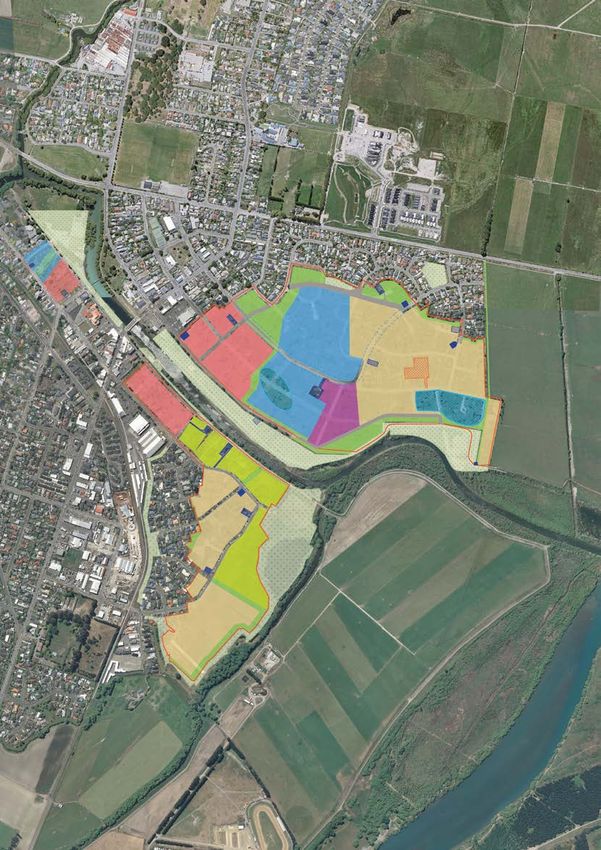
PAGE 195. The Pines Beach
Regeneration Area
Whakarauora i te Takiwā o Tātahi Paina
East of Kaiapoi, The Pines Beach regeneration area covers about 9 hectares. Three private properties are
located here. The land is predominantly stabilised sand dunes or river sand and the area is subject to
variable flood risk, land damage and risk of sea level rise. Surrounding land uses which have also been
taken into account include the Tūhaitara Coastal Park, Council reserves, and proximity to Saltwater Creek.
This area is currently zoned residential. Taking these factors into consideration, and balancing the land use
assessment criteria with written comments, the agreed land uses for The Pines Beach regeneration area
include land to be used for private lease; land to be managed as part of the Tūhaitara Coastal Park; and land
to be used as greenspace.
THE PINES BEACH REGENERATION AREA
Rinaldi Ave Rinaldi Ave Rinaldi Ave
Batten Grove
Dunns Ave
Kay Ave Kay Ave
.
RINALDI RESERVE
PINES OVAL
Monks Parade
KEY
Regeneration area
Dunns Ave
Private lease
Batten Grove
Recreation and ecological linkage
Tūhaitara Coastal Park
Chichester St Utility
Existing reserve
MCGARRY
PLACE Private property
RESERVE
WDC property
Dunns
Reinstate path /cycleway
Ave
Reid Mem
orial Ave Consented Pines Community
REID MEMORIAL
AVENUE RESERVE
Hall (replacement of the
earthquake damaged hall)
Beach Rd
Beach Rd Fea
the
rsto
nA
ve
TŪHAITARA Boundaries within regeneration
COASTAL PARK
areas are approximate only
PAGE 20You can also read