Section 5: Site Descriptions Guide to the site descriptions - Kingston Council
←
→
Page content transcription
If your browser does not render page correctly, please read the page content below
Section 5: Site Descriptions

Guide to the site descriptions                      process. It is not an exhaustive list of
The following pages set out details of:             constraints and but provides an indicative
                                                    guide.
• Those existing waste transfer sites
identified in Schedule 1 which are likely to        Comments from Previous
be developed as waste management                    Consultations: These are the principal
facilities during the period 2011-2016,             issues raised in relation to the site at
and;                                                either the Preferred Option consultation
• Those existing industrial areas where             (July-October 2009) or the Additional Sites
additional waste management capacity                consultation (February- March 2010). The
may be suitable and are identified in               table shows how the issues raised have
Schedule 2.                                         been addressed.

Proposals Map Designations: These set               Key Issues to Consider: This section
out the designations covering the site on           sets out the key issues that developers
the relevant borough’s Proposals Map.               should consider when putting forward a
They are correct as of September 2010               waste management scheme for the site.
but may be amended as boroughs update               The guide does not constitute a
their Development Plan. Please note that            comprehensive list of criteria for
the maps accompanying the site details              development and all schemes with need
are at different scales.                            to comply with the Development Plan
                                                    policies of the relevant borough.
Constraints: These are the principal
constraints identified in the site selection

                                               56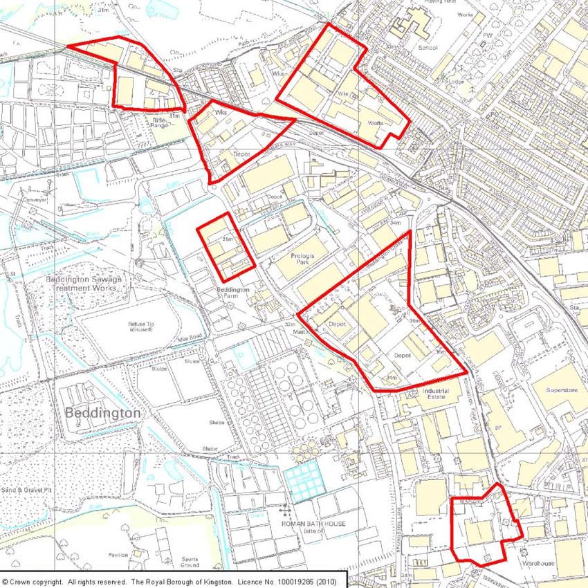
EXISTING SITE IDENTIFIED IN SCHEDULE 1:

DEVELOPMENT OF THESE SITES IS ANTICIPATED DURING THE PLAN PERIOD 2011-
                                2016

INDEX
Site reference   Site Description                                Borough

1                Factory Lane Transfer Station                   Croydon
6                Villiers Road HRRC                              Kingston
9                Garth Road HRRC                                 Merton
18               The Viridor Recycling and composting centre     Sutton
                 Beddington
126              Benedict Wharf Transfer Station (also a small   Merton
                 MRF onsite)
27               SITA transfer station, Weir Road                Merton
17               Country Skip Hire                               Sutton

                                           57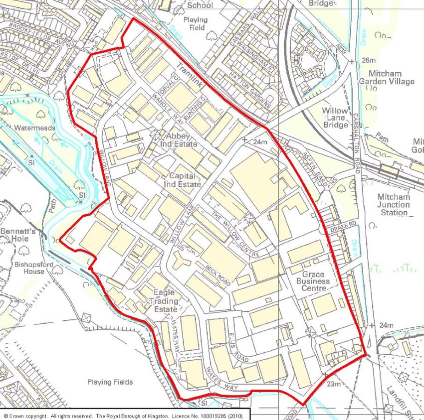
SITE 1: FACTORY LANE
                                         Croydon

Site Description: The site is part of a larger industrial area. At present, the site
accommodates a household reuse and recycle centre and waste transfer station. Active
gas holders lie to the north-west of the site and power lines are overhead.

The Wandle Park lies to the south-east of the site. Access from the site is via Factory Lane
to the trunk road network, A235/A236.

Site Area: 1.79ha

                                             58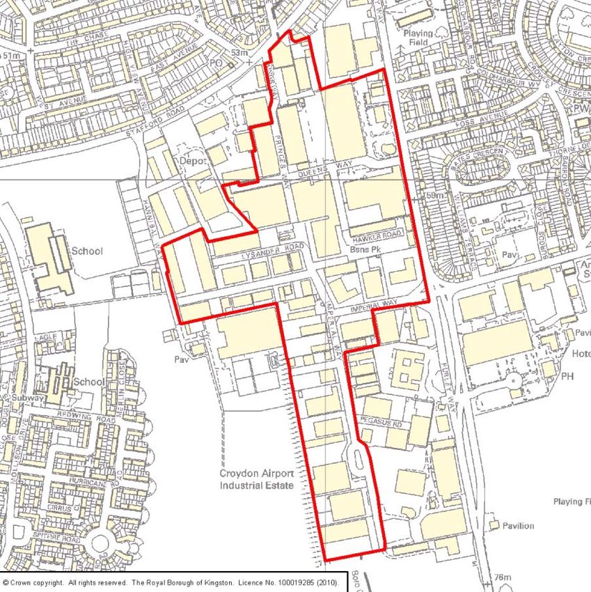
Proposals Map Designations: Strategic Employment Location (Croydon Adopted Unitary
Development Plan, 2006). It is also within an Archaeology Priority Zone, subject to the
Croydon Panorama arc, close to Local Open Land and a Green Corridor and partly within
an Area at Risk of Flooding.

Site Constraints:
The site is partly within Flood zone 3b and contains an archaeological site. The site has
limited opportunities for sustainable transport of materials in and out of the site.

Site Opportunities:
The site is an established industrial area, with established waste use.

Objections from Previous Consultations:

Issue Raised                       Action Taken
Pollution (air, water, noise)      Policy WP7 strengthened, see paragraph 1 particularly
Nearby residential area            Policy WP7 strengthened, see paragraph 1 particularly
Traffic                            Policy WP7 strengthened, see point (g) particularly

Issues to consider:
Developers of the site for waste management purposes should pay particular attention to
the following (please note this list is not exhaustive):
   • Designing the site so that operations are carried out within a fully enclosed building;
   • Protecting the residential amenity of those properties adjacent to, or in the vicinity of
        the site, especially with regard to air emissions and noise impacts;
   • Protecting the amenity of those using the nearby Wandle Park;
   • Limiting traffic movements so as not to hinder traffic flow on the surrounding roads,
        nor cause safety concerns for other road and pavement users;
   • Minimising flood risk on- and off-site;
   • Any development of this site must consider its siting within the Croydon Panorama
        arc;
   • Remediating the site of historical contamination
   • The f ollowing protected sp ecies and habitats that h ave bee n si ted on or w ithin t he
        vicinity of the site within the last five years: West European Hedgehog, Stag Beetle
        and House Sparrow.

Delivery: This site is owner occupied by Croydon Borough Council and is in use as a waste
site. Together with Site 9 (Garth Road Civic Amenity Site) and Site 6 (Villiers Road), the
South London Waste Partnership has offered this site to potential operators as part of their
ongoing work to procure a contract to treat the partner boroughs' residual municipal waste.

                                              59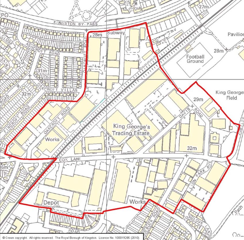
There is potential for one or more of these transfer stations to be developed during the Plan
period 2011-2016.

                                             60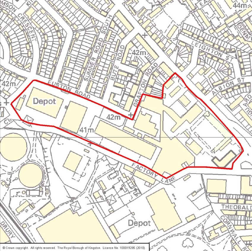
SITE 9: GARTH ROAD CIVIC AMENITY SITE

                                             Merton

Site Description: The site is part of a larger industrial area which Merton Council wholly
owns. At pr esent, t he si te acco mmodates a hous ehold r euse and r ecycle ce ntre and
Merton C ouncil’s highways depot w ith sa lt storage. To the nor th o f t he si te i s a w aste
transfer si te a nd a pl ant hi re op erator, t o t he east and s outhwest ar e hous es and t o t he
southeast are industrial units. Along the southwestern boundary are a ’Green Corridor’ and
a SINC.

From the A24 to the south of the site, access is gained via Garth Road, which has houses
and part of the Garth Road Industrial Estate along it.
                                                61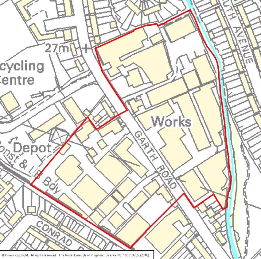
Site Area: 2.05ha

Proposals Map Designations: Industrial A rea, S pecial I ndustrial Z one an d a par t o f t he
site incorporates Site Proposal 17P proposing a Waste Treatment Facility including a buffer
zone and environmental improvements (Merton Adopted Unitary Development Plan, 2003).
The London Plan protects the existing waste management facility.

Site Constraints: No direct access to the Strategic Road Network, limited opportunities for
sustainable transport and is adjacent to a locally important Nature Conservation Area.

Site Opportunities: The site is in single ownership, is in an established industrial area and
a part is currently being used as a waste management facility.

Objections from Previous Consultations:

Issue Raised                       Action Taken
Pollution                          Policy WP7 strengthened, see paragraph 1 particularly
Nearby residential area            Policy WP7 strengthened, see paragraph 1 particularly
Traffic                            Policy WP7 strengthened, see point (g) particularly

Issues to consider:
Developers of the site for waste management purposes should pay particular attention to
the following (please note this list is not exhaustive):
•     Designing the site so that operations are carried out within a fully enclosed building;
•     Protecting the residential amenity of those properties adjacent to, or in the vicinity of
      the site, especially with regard to air emissions;
•     Limiting traffic movements so as not to hinder traffic flow on the surrounding roads, nor
      cause safety concerns for other road and pavement users;
•     Respecting and enhancing the adjacent Nature Conservation Area;
•     Developing a facility which could make heat and/or power available to local users
•     Discussion with the local authority regarding the potential relocation of the household
      waste and r ecycling centre, sh ould this be di splaced an d sh ould t he facility need
      replacing
•     Remediating the site of historical contamination
•     No protected species have been sited onsite. The following protected species and
      habitats have been sited within the vicinity of the site:
-     To the north east of the site at Mayflower Park, the following have been recorded:
      Common starling, Hedge Accentor, Herring Gull, Lesser Noctule Pipistrellus
      pipistrellus, Soprano Pipistrelle and Daubenton’s Bat.
-     To the north east of the site at Joseph Hood Recreation Ground, a Lesser Noctule,
      Pipistrellus and Song Thrushes have been sighted.
                                              62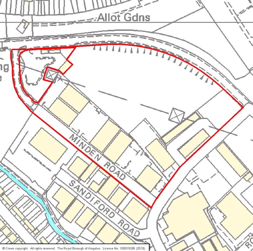
-    To the south west of the site, at postcode KT4 8N: frogs, toads and starlings have
     been sighted.
-    In 2007, in Mayflower Park, the comment on Eurasian Badgers states “may be
     foraging near the raised viewpoint area. There are no badgers on site.”

Delivery: This site is owner occupied by Merton Borough Council and is in use as a waste
site. Together with Site 1 (Factory Lane) and Site 6 (Villiers Road), the South London Waste
Partnership has offered t his site t o p otential oper ators as part of t heir ong oing w ork t o
procure a c ontract to t reat t he par tner b oroughs' r esidual municipal w aste. There i s
potential for one or more of these transfer stations to be developed during the Plan period
2011-2016.

                                               63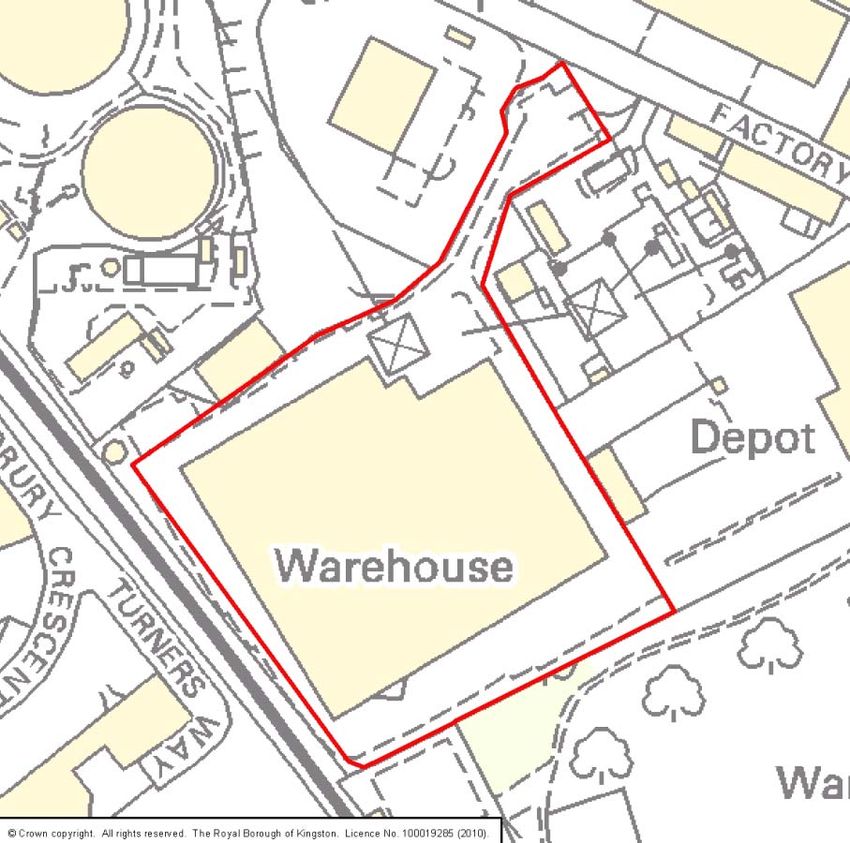
SITE 126: BENEDICT WHARF WHOLE SITE

                                            Merton

Site Description: This existing waste site presently occupied by a waste transfer facility,
Materials Recycling Facility, vehicle depot and a chemical plant. The Benedict School is
opposite the main access point to the north of the site, there are playing fields to the east,
on the opposite side of the tramline there is an industrial estate to the west, and there are
houses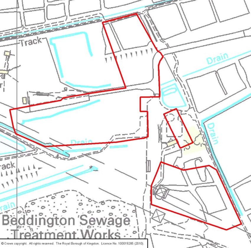
Site Area: 3.87ha

Proposals Map Designations: Industrial Area, Site Proposal 10P proposing a B1 use and
Site P roposal 2 6P pr oposing waste t reatment facilities, t raffic management m easures and
environmental i mprovements, adjacent t o MOL, O pen Space, S INC, G reen C hain, Green
Corridor and C onservation A reas (Merton Adopted U nitary D evelopment P lan, 2 003). T he
site is within an industrial area designated as a ‘Strategic Industrial Location’ in the London
Plan and as an existing waste site, is protected by the London Plan.

Site Constraints: No direct access to the Strategic Road Network, limited opportunities for
sustainable t ransport, adj acent t o a Nature Conservation A rea and S trategic Views from
neighbouring Conservation Areas, is an archaeological site.

Site Opportunities: The si te i s designated for i ndustrial pur poses and i s currently bei ng
used as a w aste management facility. T he si te i s designated as a ‘ Strategic Industrial
Location’ in the London Plan and as an existing waste site is protected by the London Plan.

Objections from Previous Consultations:

Issue Raised                       Action Taken
Views from Conservation Areas      Policy WP7 strengthened, see paragraph 1 and points
                                   (c) and (i) particularly
Nearby residential area            Policy WP7 strengthened, see paragraph 1 particularly
Traffic                            Policy WP7 strengthened, see point (g) particularly

Issues to consider:
Developers of the site for waste management purposes should pay particular attention to
the following (please note this list is not exhaustive):
   • Designing the site so that operations are carried out within a fully enclosed building;
   • Protecting the residential amenity of those properties adjacent to, or in the vicinity of
        the site, especially with regard to air emissions;
   • Limiting traffic movements so as not to hinder traffic flow on the surrounding roads,
        nor cause safety concerns for other road and pavement users;
   • Respecting the character and the views into and from the neighbouring Conservation
        Areas;
   • Respecting and enhancing the adjacent Nature Conservation Area;
   • Developing a facility which could make heat and/or power available to local users
   • Remediating the site of historical contamination
   • The following protected species and habitats that have been sited onsite:
           - In 2008, at Mitcham Recycling centre, Hallowfield Lane Mitcham, a Noctule
                Bat was sighted “feeding over floodlights over waste transfer station”.
                                              65
- A Pipistrellus pipistrellus and a Soprano Pipistrelle have also been sighted at
Mitcham Recycling centre.
• The following protected species and habitats have been sited within the vicinity of the
site:
- To the south west of the site at Ravensbury Park: Daubenton’s Bat, a Lesser
Noctule, a Pipistrellus pipistrellus, a Soprano Pipistrelle, a Pipistrellus, a
Noctule Bat and a Song Thrush were recorded in 2006 and 2008.
- To the north west of the site, in Morden Hall Park a Populus nigra subsp.
Betulifolia has been recorded.
- Data indicates a variety of bird and bat species, a few plant varieties and a
frog.
Delivery: At th e ti me o f w riting, SITA ( the cu rrent occupier) ha s submitted a p lanning
application to development the site for waste management purposes. The consideration of
this application m ay r esult i n the a mendment o f t he si te b oundary. In M ay 2010, S ITA
expressed no intention to vacate the site or to sell the freehold.
66SITE 27: WEIR ROAD TRANSFER STATION
Merton
Site Description: This small SITA owned site is located along the eastern boundary of the
Durnsford R oad I ndustrial A rea and t he former ope n w aste t ransfer use has temporarily
ceased w hile t he dec ision o f a pl anning appl ication for M aterials Recycling Facility is
awaited. The surrounding buildings vary between 6m and 20m high. The River Wandle runs
along its eastern boundary and t he rest of the site borders the remainder of the Durnsford
Road Industrial Area.
Access to the A218 is gained via the Durnsford Road Industrial Area.
Site Area: 0.3ha
67Proposals Map Designations: Industrial A rea, S pecial I ndustrial Z one, 1in100 y ear
floodplain, A rchaeological P riority Z one, the R iver Wandle al ong t he eastern boundary i s
MOL, S INC, G reen C hain and G reen C orridor and a Lei sure W alking R oute (Merton
Adopted Unitary Development Plan, 2003). The site is within an i ndustrial area designated
as a ‘ Strategic Industrial Loca tion’ i n t he L ondon Plan an d as a n ex isting w aste si te is
protected by the London Plan.
Site Constraints: Limited op portunities for su stainable t ransport, adj acent t o a locally
important Nature C onservation A rea and w ithin a F lood Z one an d a Loca l A rchaeological
Site.
Site Opportunities: The si te i s in an established i ndustrial area a nd, al though not
immediately on t he Strategic Road Network, it has easy access from a st rategic road. The
site is within an industrial area designated as a ‘Strategic Industrial Location’ in the London
Plan and as an existing waste site is protected by the London Plan.
Objections from Previous Consultations:
None raised for this site. However, issues to consider will be similar to those identified for
the Durnsford Road Industrial Area (Site 642)
Issues to consider:
Developers of the site for waste management purposes should pay particular attention to
the following (please note this list is not exhaustive):
• Designing the site so that operations are carried out within a fully enclosed building;
• Protecting the residential amenity of those properties adjacent to, or in the vicinity of
the site, especially with regard to air emissions;
• Limiting traffic movements so as not to hinder traffic flow on the surrounding roads,
nor cause safety concerns for other road and pavement users;
• Respecting and enhancing the adjacent Nature Conservation Area;
• Evaluating and preserving any archaeological remains;
• Minimising flood risk on- and off-site;
• Remediating the site of historical contamination
• Developing a facility which could make heat and/or power available to local users
• The following protected species and habitats are recorded as being sited on or within
the vicinity of the site, although records show that all sightings require confirmation:
common Kingfisher, Common Linnet, Common Starling, Hedge Accentor, House
Sparrow, Pipistrellus, Reed Bunting, Stag Beetle.
Delivery: At th e ti me o f w riting, th is site i s ow ned by S ITA ( a w aste op erator) who ha s
submitted a planning application for a Materials Recycling Facility on the site. In May 2010,
68SITA expressed no i ntention to vacate the site or to sell the freehold. Currently it appears
that the site has good potential for deliverability in the short, medium and longer term.
69SITE 6: VILLIERS ROAD
Kingston
Site Description: The site is the boroughs’ existing waste transfer station and household
waste and recycling centre. Existing buildings include a 20-25m high shed with 2-storey
light industrial units to the west. Thames Water’s sewage treatment works lies to the east
and the site is bordered by the River Hogsmill and the cemetery to the North.
Site Area: 1.86ha
70Proposals Map Designations: Formerly Proposals Site 26 and currently designated as a
site of archaeological importance. (Kingston Unitary Development Plan, 2005 as amended
in 2008).
Constraints: No access to the strategic road network. Access is therefore from the A2043
Cambridge Road, then via the local distributor residential roads: Hawkes Road, then Villiers
Road. Key junctions of concern are Villiers Road / Hawkes Road and Cambridge Road /
Hawks road, both of which are running at capacity at peak hours with limited opportunity for
improvement due to narrow footways and close proximity of buildings. The site is in close
proximity to a local nature conservation area to the north and south and affords no
opportunities for sustainable transport. Part of the site is also at risk of flooding.
Opportunities: The site is in existing waste use and over 100m from the nearest houses (to
the south-west of the site). The site is partially screened in the south-west corner and well
screened around the rest of the perimeter by Kingston cemetery to the north, Thames water
land to the east and a local nature conservation area to the south. The site falls within the
Hogmsill Master Plan area and therefore development must consider the implications of
this. It should be noted that the Hogmsill area has been identified as potentially suitable for
the production of heat and power as part of a decentralised energy network.
The Hogsmill River runs adjacent to the site giving potential for enhancement works to this
feature. The river is currently in a heavily engineered state in this area and improvements to
the buffer zone could be incorporated to improve the river corridor.
Objections from Previous Consultations:
Principal Issue Raised Action Taken
Traffic impact and safety concerns Policy WP7 strengthened, see point (g) particularly
Proximity to residents and local Policy WP7 strengthened, see point (c) particularly
schools
Water pollution to the Hogsmill River Policy WP7 strengthened, see point (e) and (f)
particularly
Loss of residential amenity Policy WP7 strengthened, see paragraph 1
particularly
Issues to consider:
Developers of the site for waste management purposes should pay particular attention to
the following (please note this list is not exhaustive):
• Designing the site so that operations are carried out within a fully enclosed building;
• Protecting the residential amenity of those properties in the vicinity of the site,
especially those in close proximity to the SW and in particular with regard to air
quality which is poor as a result of the cumulative effects of various activities;
71• Opportunities to improve the access to the site should be investigated. Traffic impact
on surrounding residential roads must be minimised and increased in traffic must be
avoided.
• Taking measures to maintain the existing nature conservation value of the site, with
particular attention to the Hogsmill river;
• Ensuring groundwater and watercourses are not harmed by any development and
taking opportunities to improve the river Hogsmill;
• Respecting buffer zones to the Hogsmill River, as advised by the Environment
Agency;
• Designing a facility which does not significantly impact on the adjacent metropolitan
open land.
• Remediating the site of historical contamination
• The following protected species have been sited on the site:
- In June 2008, Common Starling sightings in Kingston Cemetery noted that
they were “gathering food to take to young in waste transfer station and young
also feeding on grass”.
• The following protected species have been sited off site:
- To the north of the waste transfer site, lies Kingston Cemetery, a wide variety
of birds: House Sparrow, Song Thrush, Hedge Accentor, Common Starling,
Herring Gull, Common Kingfisher, Redwing, Sand Martin, Common Linnet,
Common Bullfinch, Lesser Redpoll, Northern Lapwing, Eurasian Hobby, Green
Sandpiper, Lesser Spotted Woodpecker have been recorded. Bat species,
Pipistrellus pipistrellus and Soprano Pipistrelle as well as a Grass Snake and
Water Vole were recorded.
- To the north/northwest of the site, at Bonner Hill Road, various species of bats
and birds have been sighted.
- Knights Park lies to west of site, where a variety of bird species such as the
Kingfisher and a variety of bat species: Common Pipistrelle, Daubenton’s Bat,
Lesser Noctule, Natterer's Bat, Pipistrellus and Soprano Pipistrelle have been
spotted.
- To the east of site, lies the Hogsmill River where various species of birds and
a water vole have been recorded.
- To the south/south east of waste transfer site, lies Berrylands, where Sand
Martins have been sighted.
- A Eurasion Badger was sighted in June 2007 at Bonner Hill Road
Delivery: This site is owner occupied by Kingston Council and is in use as a waste site.
Together with Site 9 (Garth Road Civic Amenity Site) and Site 1 (Factory Lane), the South
London Waste Partnership has offered this site to potential operators as part of their
ongoing work to procure a contract to treat the partner boroughs' residual municipal waste.
There is potential for one or more of these transfer stations to be developed during the Plan
period 2011-2016.
72SITE 18: VIRIDOR RECYCLING CENTRE
Beddington Farmlands, Beddington
Sutton
Site Description: The site is located on open land which abuts an industrial area. There is
sewage works infrastructure surrounding a significant part of the site with some industrial
uses to the east. The current waste operator has a licence for the site until 2023, after which
the site is intended to become a Country Park within the proposed Wandle Valley Regional
Park. Access is from Beddington Lane.
Site Area: 5.02ha.
73Proposals Map Designations: Metropolitan Open Land, Metropolitan Green Chain, Land
Safeguarded for the Wandle Valley Country Park, Archaeological Priority Area, Metropolitan
Site of Importance for Nature Conservation.
Constraints: No direct access to the Strategic Road Network, site intended for strategic
open space and nature conservation uses, limited opportunities for utilising sustainable
transport modes and a locally protected view.
Opportunities: Site already accommodates long-term temporary waste management uses,
the site is distant from residential areas and the vehicle routing to the site is primarily
through an industrial area.
Objections from Previous Consultations:
Principal Issue Raised Action Taken
Planning designations should be Schedule 1 indicates waste management use is a
respected temporary use and will not be continued beyond
2023 when the site will become part of the Wandle
Valley Regional Park. Also, see Schedule 4, Point
36 regarding restoration and after care
Biodiversity should be protected Policy WP7 strengthened, see point (b) particularly
The Sewage Treatment Works may This a matter being discussed between the
need to expand landowners, Thames Water Ltd, and the regulator
OFWAT
Issues to consider:
Developers of the site for waste management purposes should pay particular attention to
the following (please note this list is not exhaustive):
• Designing the site so that operations are carried out within a fully enclosed building;
• Ensuring that the site is made available for the creation of the Wandle Valley Regional
Park by the end of 2023:
• Protecting the residential amenity of those properties in the vicinity of the site,
especially with regard to air quality which is poor as a result of the cumulative effects
of various activities;
• Taking measures to maintain the existing nature conservation value of the site;
• Ensuring groundwater and watercourses are not harmed by any development;
• Ensuring that traffic to and from the site is routed to avoid residential areas as far as
possible and the volume of traffic is not unduly increased; and,
• Designing a facility which does not significantly impact on the openness of Beddington
Farmlands.
• Remediating the site of historical contamination
74• A large number of protected species and habitats have been sited. Sightings are
recorded as ‘Beddington sewage Farm’ which is adjacent to the existing waste
facilities. Species recorded in the vicinity of the site include: Annual Knawel, Arctic
Tern, Bar-tailed Godwit, Blue-Headed Wagtail, Common Bullfinch, Common
Kingfisher, Daubenton's Bat, Eurasian Curlew, Eurasian Tree Sparrow, Common
Goldeneye, Green Sandpiper, Eurasian Marsh Harrier, Lesser Spotted Woodpecker,
Stag Beetle, House Sparrow, Hedge Accentor, Lesser Redpoll, Northern Pintail, Sand
Martin, Reed Bunting, Red Kite. Northern Lapwing, Greylag Goose, Peregrine Falcon,
Black-tailed Godwit, Bar-tailed Godwit, Tree Pipit, Tundra Swan, Yellow Wagtail,
Spotted Flycatcher.
Delivery: The operator has previously submitted an application on the site, which the
Borough has resolved to grant.
.
75SITE 17: COUNTRY WASTE RECYCLING LTD
79-83 Beddington Lane, Beddington
Sutton
Site Description: The site is located within a Strategic Industrial Area with sewage works
infrastructure to the west, industrial uses to the north and east and open land to the south.
The south western portion of the site is crossed by overhead electricity cables. The site is
currently used as an open air waste transfer station with recovery activities and is
unsatisfactory within the context of modern waste management practices. Access is from
Beddington Lane and Mile Road.
Site Area: 2.38ha.
76Proposals Map Designations: Site of Importance for Nature Conservation, Strategic
Industrial Area, Archaeological Priority Area
Constraints: Non-direct access to the Strategic Road Network, partly a nature conservation
area, limited opportunities for utilising sustainable transport modes and a locally protected
view.
Opportunities: Site already accommodates waste management uses but needs
modernisation and the routing to the site should be primarily through an industrial area.
Objections from Previous Consultations:
Principal Issues Raised Action Taken
The current site has a severe amenity Policy WP7 strengthened, see paragraph 2
impact particularly
The traffic impact is severe Policy WP7 strengthened, see point (g) particularly
The site is not enclosed Policy WP7 strengthened, see paragraph 2
particularly
The site is near a school Policy WP7 strengthened, see point (c) particularly
Issues to consider:
Developers of the site for waste management purposes should pay particular attention to
the following (please note this list is not exhaustive):
• Designing the site so that operations are carried out within a fully enclosed building;
• Ensuring there is no potential for fugitive waste as a result of good on-site storage and
effective wheel-washing facilities on site;
• Protecting the residential amenity of those properties in the vicinity of the site,
especially with regard to air quality which is poor as a result of the cumulative effects
of various activities;
• Ensuring that traffic to and from the site is routed to avoid sensitive receptors and
residential properties as far as possible and the volume of traffic is not unduly
increased;
• Taking measures to maintain the existing nature conservation value of the site and
providing off-site mitigation measures if this is not possible;
• Ensuring groundwater and watercourses are not harmed by any development; and
• Designing a facility which does not severely impact on the openness of Beddington
Farmlands.
• Remediating the site of historical contamination
• The following species and habitats have been sited on or in the vicinity of the site: stag
beetle, Eurasian Tree, Sparrow, Common Starling, Common Frog, House Sparrow,
Cornflower, Caraway
77Delivery: The operator has previously submitted an application on the site, which the
Borough has resolved to grant. An application for a combined heat and power facility has
been submitted but not yet determined. The consideration of this application may result in
the amendment of the site boundary.
78EXISTING SITE IDENTIFIED IN SCHEDULE 2:
DEVELOPMENT OF UP TO SEVEN HECTARES WITHIN THE FOLLOWING
INDUSTRIAL AREAS IS ANTICIPATED DURING THE PLAN PERIOD 2016-2021
INDEX
Site Reference Site Description Borough
102 Purley Way, Lysander Road and Imperial Croydon
Way Industrial Area
105 Factory Lane Industrial Estate Croydon
125 Croydon Factory Lane (South Side) Croydon
99 Croydon Purley Oaks Highway Depot Croydon
351 /352 /353 Chessington Industrial Area Kingston
641/642/651 Durnsford Road / Plough Lane Industrial Merton
Area
702 Garth Road Industrial Area Merton
69 Willow Lane Industrial Area Merton
1006 The Wandle Valley Trading Estate (part of) Sutton
491 Kimpton Industrial Estate, Land north of Sutton
Minden Road
5312/532/533/534/535/5 Beddington Industrial Area Sutton
39
79SITE 102: PURLEY WAY, LYSANDER ROAD AND IMPERIAL WAY INDUSTRIAL
AREAS
Croydon
Site Description: The i ndustrial ar ea l ies on C roydon / Sutton bo undary. A t pr esent, t he
site is a multi-use, m ulti-occupier t rading e state. E xisting use s include manufacturing,
warehousing/storage/distribution, w holesale and m otor r etail a mongst ot hers. E xisting
buildings are pr edominantly cl added st eel frame co nstruction, with a hei ght o f u p to
approximately 15 metres.
The site has direct access to the A23, which forms the eastern boundary of the site. Routing
on t he A 23 bey ond the bo undaries of t he si te i s in a pr imarily r esidential and am enity
80setting. Open, public space, including sports grounds, surround the southern perimeters of
the industrial area.
The si te l ies above a protected g roundwater aq uifer. A ny w aste r elated d evelopment o n
this site w ill t herefore require par ticular attention an d i nvestigation o f t his issue ( see ‘ site
constraints’ below).
Site Area: 24.69ha
Proposals Map Designations: Strategic Employment Location (Croydon Adopted Unitary
Development Plan, 2006). It is also within an Archaeology Priority Zone, subject to the
Croydon Panorama arc, adjacent to Metropolitan Open Land. Sutton Council policies will
also be relevant. A Grade II Listed Building is nearby. A locally important Nature
Conservation Area is also adjacent to the site.
Site Constraints:
The site is close to a locally important nature conservation area, has limited opportunities for
sustainable transport, the site contains a local archaeological site.
The site lies above a protected groundwater aquifer. The Environment Agency will object in
principle to any proposed waste-related development onsite which has the risk of leaching
pollutants. T he A gency will al so obj ect i n pr inciple t o any waste-related pr oposal w hich
contains or generates liquid waste, especially if hazardous.
To ensure that risks of pollution to groundwater are investigated and mitigated against, a full
assessment of the risks will be needed at the pre-planning application stage, with full liaison
with t he E nvironment Agency. T he p urpose o f t his assessment w ould be t o co nsider t he
inherent risks associated with the proposed waste activity and provide sufficient information
to evaluate the likelihood of a release being made. Storage of waste prior to processing also
poses a significant risk and will need to be considered at this pre-application stage.
Site Opportunities: The site is an established Industrial Area.
Objections from Previous Consultations:
Issue Raised Action Taken
Water pollution Requirement for any proposal for waste related
development on this site is accompanied by a full
assessment of the risk to ground water. Full liaison with
the Environment Agency is required at the pre-planning
application stage.
Air pollution Policy WP7 strengthened, see paragraph 1 particularly
81Loss of residential amenity Policy WP7 strengthened, see paragraph 1 particularly
Nearby residential area Policy WP7 strengthened, see paragraph 1 particularly
Traffic Policy WP7 strengthened, see point (g) particularly
Issues to consider:
Developers of the site for waste management purposes should pay particular attention to
the following (please note this list is not exhaustive):
• Designing the site so that operations are carried out within a fully enclosed building;
• Protecting the residential amenity of those properties adjacent to, or in the vicinity of
the site, especially with regard to air emissions;
• Respecting the special character of the historic airport located in close proximity;
• Limiting traffic movements so as not to hinder traffic flow on the surrounding roads;
• Respecting and enhancing the adjacent Nature conservation Area;
• Minimising flood risk on- and off-site;
• Any development of this site must consider its siting within the Croydon Panorama arc;
• Remediating the site of historical contamination
• The following species and habitats have been sited on or in the vicinity of the site:
Annual Knawel, Common Frog, Common Lizard, Common Starling, Dark Green
Fritillary, House Sparrow, Sea Barley, Silver-studded Blu, Sky Lark, Slow-worm, Song
Thrush, Spotted Flycatcher, Stag Beetle, West European Hedgehog
Delivery: There are opportunities for some waste management facility development in the
second half of the plan period.
82Site 105: FACTORY LANE INDUSTRIAL AREA
Croydon
Site Description: The si te i s an existing i ndustrial a rea and i s currently i n multiple
ownership and occu pied by m ultiple t enants. U ses include s mall l ight i ndustrial a nd
commercial businesses. There is also a Territorial Army premises and a petrol filling station.
The borough’s transfer station and a reuse and recycle centre lies to the south of the site.
The Wandle Park lies close by, to the south of the site. Active gas holders lie to the south-
west of the site and power lines are nearby.
83Access from part of the site is to Mitcham Road and for the rest access is via Factory Lane
to the trunk road network, A235/A236.
Site Area: 7.02ha
Proposals Map Designations: Strategic Employment Location (Croydon Adopted Unitary
Development Plan, 2006). It is also within an Archaeology Priority Zone, subject to the
Croydon Panorama arc, close to Local Open Land and a Green Corridor and partly within
an Area at Risk of Flooding.
Site Constraints:
The site is close to a local Nature Conservation Area. The site has limited opportunities for
movement of waste using sustainable transport. The site is within Flood Zone 2/3b. The
site is also an archaeological priority zone.
Site Opportunities:
The site is an established industrial area, with established waste use adjacent, to the south.
Objections from Previous Consultations:
Issue Raised Action Taken
Pollution (air, water, noise) Policy WP7 strengthened, see paragraph 1 particularly
Nearby residential area Policy WP7 strengthened, see paragraph 1 particularly
Traffic Policy WP7 strengthened, see point (g) particularly
Impact wildlife and people using Policy WP7 strengthened, see paragraph 1 particularly
the adjacent Wandle Park
Issues to consider:
Developers of the site for waste management purposes should pay particular attention to
the following (please note this list is not exhaustive):
• Designing the site so that operations are carried out within a fully enclosed building;
• Protecting the residential amenity of those properties adjacent to, or in the vicinity of
the site, especially with regard to air emissions and noise impacts;
• Protecting the amenity of those using the nearby Wandle Park;
• Limiting traffic movements so as not to hinder traffic flow on the surrounding roads, nor
cause safety concerns for other road and pavement users;
• Minimising flood risk on- and off-site;
• Any development of this site must consider its siting within the Croydon Panorama arc;
• Remediating the site of historical contamination
• The following protected species and habitats have been sited onsite or in the vicinity of
the site: Stag beetle, house sparrow and common starling.
84Delivery: Parts of the north-eastern section of the site are recently developed or unlikely to
come forward, however, t here could be o pportunities for some waste m anagement facility
development in the second half of the plan period.
85Site 125: FACTORY LANE (SOUTH SIDE)
Croydon
Site Description: The si te i s part o f a l arger i ndustrial ar ea. A t pr esent, t he si te
accommodates a warehouse occupied by Tesco. It is adjacent to existing waste activity (a
transfer station and household re-use and recycling centre) and t he local authority’s motor
vehicle depot. S urrounding uses include small light industrial and commercial businesses.
Active gas holders lie to the north-west of the site and power lines are overhead.
The si te is bordered t o t he so uth-east by t he Wandle Park. A ccess from t he si te i s via
Factory Lane to the trunk road network, A235/A236.
Site Area: 3.11ha
86Proposals Map Designations: Strategic Employment Location (Croydon Adopted Unitary
Development Plan, 2006). It is also within an Archaeology Priority Zone, subject to the
Croydon Panorama arc, adjacent to Local Open Land and a Green Corridor and partly
within an Area at Risk of Flooding.
Site Constraints:
Site is close to a locally important nature conservation area, has limited opportunities for
sustainable transport, is within Flood Zone 3b, contains a local archaeological site.
Site Opportunities:
The site is an established industrial area, with established waste use adjacent.
Objections from Previous Consultations:
Issue Raised Action Taken
Pollution (air, water, noise) Policy WP7 strengthened, see paragraph 1 particularly
Nearby residential area Policy WP7 strengthened, see paragraph 1 particularly
Traffic Policy WP7 strengthened, see point (g) particularly
Impact wildlife and people using Policy WP7 strengthened, see paragraph 1 particularly
the adjacent Wandle Valley
Park
Issues to consider:
Developers of the site for waste management purposes should pay particular attention to
the following (please note this list is not exhaustive):
• Designing the site so that operations are carried out within a fully enclosed building;
• Protecting the residential amenity of those properties adjacent to, or in the vicinity of
the site, especially with regard to air emissions and noise impacts;
• Protecting the amenity of those using the adjacent Wandle Park;
• Limiting traffic movements so as not to hinder traffic flow on the surrounding roads, nor
cause safety concerns for other road and pavement users;
• Minimising flood risk on- and off-site;
• Any development of this site must consider its siting within the Croydon Panorama arc;
• Remediating the site of historical contamination
• The following protected species and habitats have been sited onsite or in the vicinity of
the site: Stag beetle, house sparrow and common starling, west European Hedgehog
and mistletoe.
Delivery: Oyster Jersey Property Fund owns the freehold of this site and the current tenant,
Tesco, has 10 years remaining on its current lease.
87Site 99: PURLEY OAKS HIGHWAYS DEPOT
Croydon
Site Description: The si te pr esently acco mmodates a c ouncil hi ghways and motor
transport depot. The site is primarily an open storage yard, with some buildings.
The site is bordered to the south-east by business premises and railway lines. Residential
properties l ie a djacent, t o t he north a nd s ome scr eening i s in place here. A pond l ies
adjacent t o t he west. To t he north-west of t he si te i s a household w aste and r ecycling
centre and the A235.
88The si te h as access directly on t o A235. R outing t o t he si te o n t he A 235 i s in a primarily
residential setting.
The predominant building height in the area is two storey. A five storey office development
is located within 50m of the site.
Site Area: 1.06ha
Proposals Map Designations: The site is within an Archaeology Priority Zone (Croydon
Adopted Unitary Development Plan, 2006), is adjacent to Local Open Land and adjacent to
a Green Corridor. It is partly within an Area at Risk of Flooding.
Site Constraints:
Site is within Flood Zone 3b, contains a local archaeological site, has limited opportunities
for sustainable transport.
The si te l ies above a Source P rotection Z one 2 ar ea. The si te i s therefore u nlikely t o be
suitable for any waste-related proposal which contains or generates liquid waste, especially
if hazardous. To ensure that risks of pollution to groundwater are investigated and mitigated
against, a full assessment of the risks will be needed at the pre-planning application stage,
with full liaison with the Environment Agency. The purpose of this assessment would be to
consider t he i nherent r isks associated w ith t he pr oposed w aste act ivity and pr ovide
sufficient information to evaluate the likelihood of a r elease being made. Storage of waste
prior to processing also poses a significant risk and will need to be considered at this pre-
application stage.
Any dev elopment m ust pr ovide e nhancements to t he onsi te w etland h abitat a nd must
ensure no net loss of wetland habitat.
Site Opportunities:
The site lies next to an existing HWRC facility.
Objections from Previous Consultations:
Issue Raised Action Taken
Pond has recorded sightings of Any dev elopment of t he si te must p rovide
Kingfisher, common frog and enhancements to t he onsite w etland ha bitat and must
stag beetles (a protected ensure no net loss of wetland habitat.
species)
Nearby residential area Policy WP7 strengthened, see paragraph 1 particularly
Traffic Policy WP7 strengthened, see point (g) particularly
89Issues to consider:
Developers of the site for waste management purposes should pay particular attention to
the following (please note this list is not exhaustive):
• Designing the site so that operations are carried out within a fully enclosed building;
• Protecting the residential amenity of those properties adjacent to, or in the vicinity of
the site, especially with regard to air emissions;
• Limiting traffic movements so as not to hinder traffic flow on the surrounding roads;
• Respecting and enhancing the onsite wetlands habitat
• Minimising flood risk on- and off-site;
• Any development of this site must consider its siting within the Croydon Panorama arc;
• Remediating the site of historical contamination
• The following protected species and habitats have been sited onsite or in the vicinity of
the si te: House Sparrow, West European H edgehog, C ommon K ingfisher, C ommon
Frog, Common T oad, Stag Beetle, Vespertilionidae, Dingy S kipper, M istletoe, S mall
Heath, Chalk Hill Blue, Red Hemp-nettle, White Helleborine, Shepherd’s-needle
Delivery: The site is owned by Croydon Council. A recent planning application to expand
the layout of the adjacent household waste and recycling centre remains undecided.
90CHESSINGTON INDUSTRIAL ESTATE
Chessington, Kingston
Site Description: The site is located in the south of the borough and is currently in multiple
occupancy with a mixture of industrial, warehousing and technology units. Existing
buildings range from around 18 metres to 30 metres high.
Metropolitan open land abuts the industrial area to the east. The site is bordered with
residential properties to the south, the west and north east.
The A3 abuts the site along its northern edge and an elevated railway line runs through the
site, surrounded by a green corridor.
91Routing to the site is from the A240 is via Cox Lane and Jubilee Way which are suitable for
industrial traffic.
Site Area: 34.91
Proposals Map Designations: Industrial Area (Kingston Unitary Development Plan, 2005
as amended in 2008) with a green corridor following the elevated railway line through the
site.
Constraints: Residential properties adjoin the site to the south, east and north-west of the
site. The site is adjacent to metropolitan open space. Local open space and a locally
important nature conservation site lie to the south of the site. A drain runs adjacent to the
NW portion of this site and development within 5 metres of the top of its bank should be
avoided where possible. 7.5 ton lorry ban zones are in place in some nearby residential
areas. Heavy Goods Vehicles should be prevented from using Hook Road South and from
heading west under the rail bridge on Cox Lane. Routing to the site is from the A240 is via
Cox Lane and Jubilee Way which are suitable for industrial traffic.
Opportunities: Site already accommodates industrial uses, parts of the site (particularly the
eastern sections of the site) are distant from residential areas and the permitted vehicle
routing to the site is primarily through an industrial area. The site has no flood risk issues.
Some existing buildings may be suitable for adaptation to waste use. Development of any
site within the industrial area should consider implications of the nearby Tolworth
Regeneration Strategy area. There may be opportunities for the supply of heat and power
to Tolworth.
Objections from Previous Consultations:
Principal Issue Raised Action Taken
Traffic Policy WP7 strengthened, see point (g) particularly
Proximity to residents and local Policy WP7 strengthened, see point (c) particularly
schools
Pollution Policy WP7 strengthened, see point (e) and (f)
particularly
Loss of residential amenity Policy WP7 strengthened, see paragraph 1
particularly
Issues to consider:
Developers of the site for waste management purposes should pay particular attention to
the following (please note this list is not exhaustive):
• Designing the site so that operations are carried out within a fully enclosed building;
92• Protecting the residential amenity of those properties in the vicinity of the site,
especially with regard to air quality which is poor as a result of the cumulative effects
of various activities;
• Taking measures to maintain the existing nature conservation value of the site, with
particular attention to the green corridor which runs alongside the rail line through the
site;
• Ensuring groundwater and watercourses are not harmed by any development;
• Ensuring that traffic to and from the site is routed to avoid residential areas as far as
possible and the volume of traffic is not unduly increased; and,
• Designing a facility which does not significantly impact on the adjacent metropolitan
open land.
• Remediating the site of historical contamination
• No pr otected s pecies and h abitats have bee n recorded onsite. T he following
protected species and habitats have been sited in the vicinity of the site:
- To the south of the site at ‘Bonesgate Drake Road Open Space-Moor Lane’ sightings
of birds, a lizard, a bat and a stag beetle have been recorded
- At the location given as “Bonesgate Cox lane” various bird species have been
recorded.
- To the south of the site, a common starling and a house sparrow were seen at post
code KT9 2BW and to the south west of the site, at postcode KT9 1BY a frog, house
sparrow, smooth newt, stagbeetle and west European hedgehog have been recorded.
- At postcode KT9 1FX, a stagbeetle was sighted
- At the location given as ‘Hook,’(King Edward Rec), redwings have been sighted.
Delivery: There are opportunities for some waste management facility development in the
second half of the plan period.
.
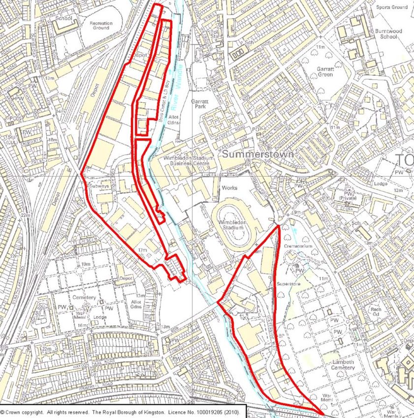
93SITES 641 / 651 / 652: THE DURNSFORD ROAD AND PLOUGH LANE INDUSTRIAL
AREA
Merton
Site Description:
The site consists of two parts, to the north and south of Plough Lane and both industrial
areas are at present in multiple use and multiple occupation. Buildings range between
approximately 8m-20m high and there is a variety of occupants such as: a bus depot, Abel
& Cole, Cappagh depot, Wickes, Vauxhall garage, Homebase, Booker Wholesale, Oddbins
Depot, Tarmac batching plant and the BT fleet depot. Near the boundaries of the site
94are the River Wandle, allotments, cemeteries, railway lines, residential properties, the
Wimbledon Stadium a other industrial properties.
The northern part of the site gains direct access from the A218 (Durnsford Road) and the
southern part of the site gains direct access from the B235 (Plough Lane).
Site Area: 25.55ha
Proposals Map Designations: Industrial A rea, w ithin t he 1in100 y ear floodplain an d an
Archaeological Priority Zone, and the River Wandle on the western boundary is within MOL,
a SINC and a Green Corridor (Merton Adopted Unitary Development Plan, 2003)
Site Constraints: Limited opportunities f or su stainable transport, adjacent t o a
Conservation ar ea and N ature C onservation A rea, and w ithin a Flood Z one an d a L ocal
Archaeological Site.
Site Opportunities: The si te i s an established i ndustrial ar ea t hat i s desi gnated as a
‘Strategic Industrial Location’ in the London Plan and gains access from a ne arby strategic
road.
Objections from Previous Consultations:
Issue Raised Action Taken
Potential loss of employment Planning cannot control the number of jobs on any site,
only the use of the site.
Air Pollution (including dust) Policy WP7 strengthened, see paragraph 2 and point (e)
particularly
Odour Policy WP7 strengthened, see paragraph 2 and point (h)
particularly
Noise Policy WP7 strengthened, see paragraph 2 and point (f)
particularly
Litter Policy WP7 strengthened, see paragraph 2 and points
(h) and (i) particularly
Loss of residential amenity Policy WP7 strengthened, see paragraph 1 and point (i)
(visual intrusion) particularly
Nearby residential area, school Policy WP7 strengthened, see paragraph 1 and point (c)
and hospital particularly
Traffic Policy WP7 strengthened, see point (g) particularly
Safety and amenity of local Policy WP7 strengthened, see points (a), (g) and (i)
cycle routes particularly. Note other cycling related LDF policies
would also apply.
Threat to the neighbouring Policy WP7 strengthened, see points (a), (b) and (d)
nature conservation area and particularly and note that the site area is limited to the
95contamination of the River previously developed area
Wandle
Effect on neighbouring business Policy WP7 strengthened, see paragraph 1 and point (i)
viability particularly. Is in an established industrial area that is
designated as a ‘Strategic Industrial Location’ in the
London Plan
Located in Flood Zone Policy WP7 strengthened, see point (d) particularly
Close to the future Wandle Policy WP7 strengthened, see point (a) particularly
Valley Regional Park
Issues to consider:
Developers of the site for waste management purposes should pay particular attention to
the following (please note this list is not exhaustive):
• Designing the site so that operations are carried out within a fully enclosed building;
• Protecting the residential amenity of those properties adjacent to, or in the vicinity of
the site, especially with regard to air emissions;
• Limiting traffic movements so as not to hinder traffic flow on the surrounding roads, nor
cause safety concerns for other road and pavement users;
• Respecting and enhancing the adjacent Nature Conservation Area;
• Evaluating and preserving any archaeological remains;
• Minimising flood risk on- and off-site;
• Respecting buffer zones to the River Wandle, as advised by the Environment Agency;
• Remediating the site of historical contamination
• Developing a facility which could make heat and/or power available to local users
• No protected species and habitats have been recorded on site. The following
protected species and habitats have been recorded within the vicinity of the site:
Common Frog, Common Toad, Smooth Newt, Common Kingfisher, Common Linnet,
Common Starling, Hedge Accentor, House Sparrow, Reed Bunting, Common
Pipistrelle, stag beetle, slow-worm, Pipistrellus pipistrellus, Vespertilionidae, West
European Hedgehog.
Delivery: At th e ti me of writing, th is site i s in m ultiple ownership and multiple occupation.
There are opportunities for some waste management facility development in the second half
of the plan period.
96SITE 702: GARTH ROAD INDUSTRIAL AREA
Merton
Site Description: The si te i s part o f a l arger i ndustrial ar ea a nd at pr esent, t he si te i s a
multi-use, m ulti-occupier i ndustrial est ate. Existing bui ldings on t his site v ary gr eatly f rom
pre-war b rick workshops to more modern s teel cl ad w arehouses and hei ghts vary f rom
approx 6-20m. The site borders the remainder of the industrial area along the northwestern
boundary and residential properties along the northeastern and southern boundaries. Along
the w estern and eastern bo undaries are SINCs and G reen C orridors with t rees and
vegetation, which screen the site from the residential properties beyond
97From t he A 24 t o t he so uth o f t he si te, a ccess is gained v ia Garth R oad, w hich i s a
residential access road that bisects the site.
Site Area: 5.6ha
Proposals Map Designations: Industrial Area and the eastern part of the site is within the
1in100 year floodplain (Merton Adopted Unitary Development Plan, 2003)
Site Constraints: No direct access to the Strategic Road Network, limited opportunities for
sustainable transport, adjacent to a Nature Conservation Area and within a Flood zone.
Site Opportunities: The site is an established industrial area.
Objections from Previous Consultations:
Issue Raised Action Taken
Nearby residential area Policy WP7 strengthened, see paragraph 1 particularly
Issues to consider:
Developers of the site for waste management purposes should pay particular attention to
the following (please note this list is not exhaustive):
• Designing the site so that operations are carried out within a fully enclosed building;
• Protecting the residential amenity of those properties adjacent to, or in the vicinity of
the site, especially with regard to air emissions;
• Limiting traffic movements so as not to hinder traffic flow on the surrounding roads, nor
cause safety concerns for other road and pavement users;
• Respecting and enhancing the adjacent Nature Conservation Area;
• Respecting buffer zones to the Pyl Brook, as advised by the Environment Agency;
• Minimising flood risk on- and off-site;
• Remediating the site of historical contamination
• Developing a facility which could make heat and/or power available to local users
• No protected species and habitats have been recorded on site. The following
protected species and habitats have been recorded within the vicinity of the site:
Common Linnet, Common Starling, Hedge Accentor, Herring Gull, House Sparrow,
Reed Bunting, Sand Martin, Song Thrush, Slow-worm, Common Frog, Common Toad,
Daubenton’s Bat, Eurasian Badger, Lesser Noctule, Pipistrellus pipistrellus, Serotine,
Soprano Pipistrelle, West European Hedgehog
Delivery: At th e ti me of writing, th is site i s in m ultiple ownership and multiple occupation.
There are opportunities for some waste management facility development in the second half
of the plan period.
98SITE 69: WILLOW LANE INDUSTRIAL ESTATE
Merton
Site Description: The si te i s a l arge m ulti-use and m ulti-occupier i ndustrial estate w ith
some existing waste management facilities. The River Wandle runs along the southern and
western boundary of the site. There are some houses along the southeastern boundary but
the houses near the northeastern boundary are separated from the site by a tramline. At the
northern a nd s outhern ends o f t he su ite t he nei ghbouring ho uses are se parated from t he
site by a buffer strip of open land.
Road access is gained via the A237.
99Site Area: 41.45ha
Proposals Map Designations: Industrial A rea, A rchaeological P riority Z one, t he w estern
part o f t he si te i s within t he 1i n100 y ear floodplain a nd both t he R iver Wandle on t he
western boundary and Mitcham Common on the eastern boundary are MOL, SINCs, Green
Chain and Green Corridors (Merton Adopted Unitary Development Plan, 2003). The site is
designated as a ‘Strategic Industrial Location’ in the London Plan.
Site Constraints: Limited opportunities for sustainable transport, Local Archaeological Site,
adjacent to a Nature Conservation Area and within a Flood zone.
Site Opportunities: The si te t akes access from a t runk r oad, i s an established i ndustrial
area t hat i s designated as a ‘ Strategic Industrial Loc ation’ i n the Lo ndon P lan a nd has
numerous existing waste operators.
Objections from Previous Consultations:
Issue Raised Action Taken
Potential loss of employment Planning cannot control the number of jobs on any site,
only the use of the site.
Located in Flood Zone Policy WP7 strengthened, see point (d) particularly
Issues to consider:
Developers of the site for waste management purposes should pay particular attention to
the following (please note this list is not exhaustive):
• Designing the site so that operations are carried out within a fully enclosed building;
• Protecting the residential amenity of those properties adjacent to, or in the vicinity of
the site, especially with regard to air emissions;
• Limiting traffic movements so as not to hinder traffic flow on the surrounding roads, nor
cause safety concerns for other road and pavement users;
• Respecting and enhancing the adjacent Nature Conservation Area;
• Minimising flood risk on- and off-site;
• Respecting buffer zones to the River Wandle, as advised by the Environment Agency;
• Evaluating and preserving any archaeological remains;
• No protected species and habitats have been recorded on site. The following
protected species and habitats have been recorded within the vicinity of the site:
- To the north of the site at ‘Canons, Madeira Road’ the following bat species:
Pipistrellus pipistrellus, Common Pipistrelle, Soprano Pipistrelle were recorded in
2008.
- The House Sparrow sightings come from the ‘LBP Sparrows at home survey 2002’.
100You can also read