Badger County Land Information Plan
←
→
Page content transcription
If your browser does not render page correctly, please read the page content below
**UNIFORM INSTRUCTIONS FOR
  PREPARING COUNTY
  LAND INFORMATION PLANS
 March 2021

 Badger County
 Land Information Plan
 2022-2024

                                  ABOUT THIS DOCUMENT
  •   Counties can either plan to use the Microsoft Word version of this document as a template for
      their 2022-2024 plan, or update their 2018 plan document.

                  Flag icons mark changes made for the 2021 Instructions
                             (relative to the 2018 Uniform Instructions).
  •   All out-of-date content from the county’s previous plan should be updated, which entails updating
      2018 content for 2021 in areas that may lack flags.
  •   Delete the “UNIFORM INSTRUCTIONS” title box at the top of this page.
  •   Update the text on cover page text as appropriate.
  •   Version. The “Version” date below should be manually updated when you save the document. You
      will need to manually change the Version line for each draft, version, and amendment.
  •   Approved/Adopted. The “Approved/Adopted” line should remain blank until the plan is approved
      by the county land information council and a date can be added, before the final plan is due on
      December 31, 2021. In the case of future amendments, plan to edit “Version” date on the cover to
      reflect the amendment date.
  •   Further instructions occur on pages 2-3, and throughout this document.
                      **DELETE THIS EXPLANATION FROM THE FINAL DOCUMENT**

 **Wisconsin Land Information Program
   Wisconsin Department of Administration
   101 East Wilson Street, 9th Floor
   Madison, WI 53703
   (608) 267-3369
   www.doa.wi.gov/WLIP
 Version: 2021-**-**
 Approved/Adopted by Land Information Council on: 2021-**-**
CONTENTS
EXECUTIVE SUMMARY ......................................................3
1 INTRODUCTION ...........................................................5
2 FOUNDATIONAL ELEMENTS ........................................8
PLSS .............................................................................................................................. 9
Parcel Mapping ......................................................................................................... 11
LiDAR and Other Elevation Data ............................................................................ 14
Orthoimagery............................................................................................................ 15
Address Points and Street Centerlines................................................................... 16
Land Use .................................................................................................................... 17
Zoning........................................................................................................................ 18
Administrative Boundaries ...................................................................................... 21
Other Layers .............................................................................................................. 24
3 LAND INFORMATION SYSTEM ...................................26
Public Access and Website Information ................................................................ 29
4 CURRENT & FUTURE PROJECTS .................................31
Project Plan to Maintain Searchable Format (Benchmarks 1 & 2) ..................... 34
Project Plan for Parcel Completion (Benchmark 3).............................................. 36
Project Plan for PLSS (Benchmark 4) ..................................................................... 37
Project #1: Indexing of documents by geography in GIS.................................... 39
Project #2: Title......................................................................................................... 39
Project #3: Title......................................................................................................... 39
Project #4: Title......................................................................................................... 40
Project #5: Title......................................................................................................... 40
Project #6: Title......................................................................................................... 40
Project #7: Title......................................................................................................... 41
Project #8: Title......................................................................................................... 41
Project #9: Title......................................................................................................... 41
**DELETE THIS EXPLANATION FROM THE FINAL DOCUMENT**
SEE COMPLETE INSTRUCTIONS ON PAGE 3
To Update Table of Contents
• Click the top-most word, “CONTENTS” Click option to “Update Table . . .”“Update entire table” OK
• Be sure to UPDATE TABLE OF CONTENTS before your final save!
To Determine What Shows Up in Table of Contents
• The Table of Contents is built automatically from something called Microsoft Word “Styles.”
• The template is programmed to display these Word Styles: Heading 1 and Heading 2.
• Find them on the Style list in the Formatting toolbar.
• Text in the document formatted as Heading 1 and Heading 2 will show up in this Table of Contents.
Alter the headings/styles as you wish. It is helpful for DOA staff if you keep Heading 1 and 2 so they
show in Table of Contents.
To Delete a Text Box (Like This One)
• Click the box so that it appears as selected Hit “Delete” on keyboard or “Cut” to remove it.
2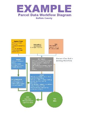
EXECUTIVE SUMMARY
**DELETE THIS EXPLANATION FROM THE FINAL DOCUMENT**
This document, the 2021 Uniform Instructions for Preparing County Land Information Plans, sets forth the directions
and minimum plan elements for 2022-2024 county land information plans. The format is designed to assist
counties in organizing their plan layout and meet the minimum requirements, which are detailed in this dual
instructions/template document.
How to Use This Template
• Instructions on using the Microsoft Word template document and on the plan process
appear in purple text and are surrounded by asterisks to distinguish them from the language which
should appear in the actual document.
• When it is time to write your plan, delete all purple instructional text, surrounded by asterisks.
• Also delete all red flag icons.
• All black text should appear in the final document, unless otherwise noted.
• Examples are included but are only intended as guides.
• To paste in content from the Microsoft Word version of your previous plan:
Copy Right-click Paste Options: Merge Formatting
Tip: Add a command called “Paste and Merge Formatting” to the Quick Access Toolbar.
• Word File Options Quick Access Toolbar Choose Commands From:
Select “All Commands” from dropdown Scroll to “Paste and Merge Formatting” “Add>>”OK
This adds a one-click Paste and Merge Formatting button to your
toolbar. Use it to paste in content that you want to match the destination
(template) document style, but retain original formatting such as italics,
hyperlinks, etc.
Executive Summary Directions
Plans should begin with an executive summary, which explains the main components and takeaways from the plan
in one page. Write for a general audience, not a technical audience. Remember that executive level decision-
makers—such as county board members—may be a key audience for the executive summary. The following
structure is recommended, but you may choose to adapt the summary.
Paragraph 1: About this Document. The first paragraph is broad. It lays out what the plan is in the most
general terms. Clearly state the purpose(s) of the plan right away. You may copy the example on the next page.
Paragraph 2: WLIP Background. As the plans are mandated by statute for participation in the WLIP, it is
important to provide brief context on the program for unfamiliar readers. Again, you may use the template
paragraph. You may also choose to alter the paragraph to be specific to your county’s history of WLIP funding.
Paragraph 3: Land Information in the County. Broadly describe how land records and GIS data are
essential to the county and county services.
Paragraph 4: Three-Year Mission Statement. Include a mission statement for the land information office.
A mission statement describes what an organization seeks to do. The mission statement can broadly mention
your most significant projects (but details on how to achieve this mission through concrete goals and objectives
should be laid out in Chapter 4).
Three-Year Mission Statement – Examples
• In the next three years, Badger County’s Land Information Office strives to be recognized for its exceptional
webmapping site, gains in governmental efficiencies by broadening the utilization of GIS, improvements in
parcel mapping accuracy, and responsiveness to meeting the land records needs of residents and businesses.
• The Land Information Office will provide efficient and high-quality services to its residents and county
departments by maintaining land records in an efficient manner, adopting standards to streamline the use of
GIS data across departments, and provide services such as a more user-friendly webmapping service.
• Badger County’s Land Information Office will provide geospatial data for the county’s comprehensive planning
process, inform future land use decision making, partner with county departments to integrate land records,
and improve public access to land records online.
Paragraph 5+: Projects Summary. Recap your major projects from Chapter 4. You can use a bulleted list, a
table, or perhaps list them in general terms in paragraph form.
3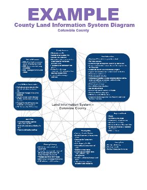
** Executive Summary – Example/Template **
About this Document. This document is a land information plan for Badger County prepared by the
land information officer (LIO) and the Badger County land information council. Under state statute
59.72(3)(b), a “countywide plan for land records modernization” is required for participation in the
Wisconsin Land Information Program (WLIP). The purpose of this document is twofold: 1) to meet WLIP
funding eligibility requirements necessary for receiving grants and retaining fees for land information, and
2) to plan for county land records modernization in order to improve the efficiency of government and
provide improved government services to businesses and county residents.

WLIP Background. The WLIP, administered by the Wisconsin Department of Administration, is
funded by document recording fees collected by register of deeds at the county-level. In 2020, Badger
County was awarded $__**k in WLIP grants and retained a total of $__** million in local register of deeds
document recording fees for land information.
                       **DELETE THIS EXPLANATION FROM THE FINAL DOCUMENT**
 You can find the total of grants awarded to and fees retained by your county in 2020 on the
 Retained Fee/Grant Report form emailed to counties on March 17, 2021.

This plan lays out how funds from grants and retained fees will be prioritized. However, as county budgets
are determined on an annual basis with county board approval, this plan provides estimated figures that
are subject to change and are designed to serve planning purposes only.

Land Information in Badger County. Land information is central to county operations, as many
essential services rely on accurate and up-to-date geospatial data and land records. A countywide land
information system supports economic development, emergency planning and response, and a host of
other citizen services. The Badger County land information system integrates and enables efficient access
to information that describes the physical characteristics of land, as well as the property boundaries and
rights attributable to landowners.

Mission of the Land Information Office. In the next three years, Badger County’s Land
Information Office strives to be recognized for its exceptional webmapping site, gains in governmental
efficiencies by broadening the utilization of GIS, improvements in parcel mapping accuracy, and
responsiveness to meeting the land records needs of residents and businesses.

Land Information Office Projects. To realize this mission, in the next three years, the county land
information office will focus on the following projects:

          Badger County Land Information Projects: 2022-2024
          Project #1    Indexing of documents by geography in GIS
          Project #2    Countywide integration of tax/assessment data with parcel polygons
          Project #3    100% PLSS remonumentation with survey grade GPS coordinates
          Project #4    Expansion of the use of mobile GPS/GIS technology
          Project #5    Document imaging improvements
          Project #6    Website development and hosting for improved access to land records

The remainder of this document provides more details on Badger County and the WLIP, summarizes
current and future land information projects, and reviews the county’s status in completion and
maintenance of the map data layers known as Foundational Elements.

                                                                                                               4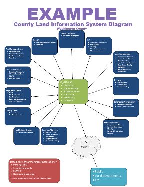
1 INTRODUCTION
In 1989, a public funding mechanism was created whereby a
portion of county register of deeds document recording fees
collected from real estate transactions would be devoted to land
                                                                         Any physical, legal, economic or
information through a new program called the Wisconsin Land              environmental information or
Information Program (WLIP). The purpose of the land information          characteristics concerning land,
plan is to meet WLIP requirements and aid in county planning for         water, groundwater, subsurface
land records modernization.                                              resources or air in this state.

The WLIP and the Land Information Plan                                   ‘Land information’ includes
                                                                         information relating to
Requirement                                                              topography, soil, soil erosion,
In order to participate in the WLIP, counties must meet certain          geology, minerals, vegetation,
requirements:                                                            land cover, wildlife, associated
    • Update the county’s land information plan at least every           natural resources, land
       three years                                                       ownership, land use, land use
    • Meet with the county land information council to review            controls and restrictions,
                                                                         jurisdictional boundaries, tax
       expenditures, policies, and priorities of the land
                                                                         assessment, land value, land
       information office at least once per year
                                                                         survey records and references,
    • Report on expenditure activities each year                         geodetic control networks, aerial
    • Submit detailed applications for WLIP grants                       photographs, maps, planimetric
    • Complete the annual WLIP survey                                    data, remote sensing data,
    • Subscribe to DOA’s land information listserv                       historic and prehistoric sites and
    • Coordinate the sharing of parcel/tax roll data with the            economic projections.
       Department of Administration in a searchable format                   – Wis. Stats. section 59.72(1)(a)
       determined by DOA under s. 59.72(2)(a)

Any grants received and fees retained for land information through the WLIP must be spent consistent
with the county land information plan.
                      **DELETE THIS EXPLANATION FROM THE FINAL DOCUMENT**
 Again, this general text (in black) is for unfamiliar readers, such as members of a county board. Edit or
 add text as you deem appropriate for your audience.
 The Uniform Instructions for Preparing County Land Information Plans are designed as a template, but
 leave flexibility as to how counties may choose to address the minimum plan components. The county
 is able to include as much detail as necessary to make the planning process useful at the local level. The
 instructions may serve as a template, but are not meant to limit the information that may be included.

Act 20 and the Statewide Parcel Map Initiative
A major development for the WLIP occurred in 2013 through the state budget bill, known as Act 20. It
directed the Department of Administration (DOA) to create a statewide digital parcel map in coordination
with counties.

Act 20 also provided more revenue for WLIP grants, specifically for the improvement of local parcel
datasets. The WLIP is dedicated to helping counties meet the goals of Act 20 and has made funding
available to counties in the form of Strategic Initiative grants to be prioritized for the purposes of
parcel/tax roll dataset improvement.

For Strategic Initiative grant eligibility, counties are required to apply WLIP funding toward achieving
certain statewide objectives, specified in the form of “benchmarks.” Benchmarks for parcel data—
standards or achievement levels on data quality or completeness—were determined through a

                                                                                                                 5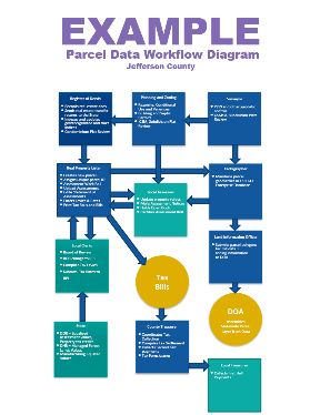
participatory planning process. Current benchmarks are detailed in the WLIP grant application, as will be
future benchmarks.
WLIP Benchmarks (For 2016-2021 Grant Years)
• Benchmark 1 & 2 – Parcel and Zoning Data Submission/Extended Parcel Attribute Set Submission
• Benchmark 3 – Completion of County Parcel Fabric
• Benchmark 4 – Completion and Integration of PLSS
More information on how Badger County is meeting these benchmarks appears in the Foundational
Elements section of this plan document.
County Land Information System History and Context
The history of land information in Badger County . . . . **
**DELETE THIS EXPLANATION FROM THE FINAL DOCUMENT**
In Chapter 1 of the plan, the county should provide an overview of the county’s land records
modernization efforts, dating back to when the WLIP was established in 1989 if possible. You may be
brief here, or provide as much detail as desired.
To paste in content from the previous Microsoft Word version of your plan:
• Copy Right-click Paste Options: Merge Formatting
County Land Information Plan Process
County land information plans were initially updated every five years. However, as a result of Act 20,
counties must update and submit their plans to DOA for approval every three years. The 2022-2024 plan,
completed at the end of 2021, is the third post-Act 20 required update.
**DELETE THIS EXPLANATION FROM THE FINAL DOCUMENT**
The minimum planning horizon for these documents is three years. The plan may incorporate a
planning horizon that is longer if the needs and priorities of the participants warrant.
You may optionally include other information about the plan writing process here, such as meeting
dates and county-level approval dates.
County Land Information Plan Timeline
• DOA release of finalized instructions by March 31, 2021.
• April–September 2021: Counties work on land info plans.
• Draft plans due to DOA by September 30, 2021 (but sooner is advised).
• Final plans with county land info council approval due by December 31st, 2021.
Plan Participants and Contact Information
Another requirement for participation in the WLIP is the county land information council, established by
legislation in 2010. The council is tasked with reviewing the priorities, needs, policies, and expenditures of
a land information office and advising the county on matters affecting that office.
According to s. 59.72(3m), Wis. Stats., the county land information council is to include:
• Register of Deeds
• Treasurer
• Real Property Lister or designee
• Member of the county board
• Representative of the land information office
• A realtor or member of the Realtors Association employed within the county
• A public safety or emergency communications representative employed within the county
• County surveyor or a registered professional land surveyor employed within the county
• Other members of the board or public that the board designates
6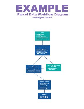
The land information council must have a role in the development of the county land information plan,
and DOA requires county land information councils to approve final plans.

This plan was prepared by the county LIO, the Badger County Land Information Council, and others as
listed below.

Badger County Land Information Council and Plan Workgroup

Name                         Title                        Affiliation               Email                      Phone
+ ROD Name**                 Register of Deeds,           Adams County              jhelgeson@co.adams.wi.us   608-339-4206
                             Land Information Officer     Land Information Office
+ Treasurer Name**           County Treasurer             Adams County              msmith@co.adams.wi.us      608-333-1234
                                                          Treasurer’s Office
+ **                         Real Property Lister

+ **                         County Board Member

+ **                         Land Information Office
                             Representative
+ **                         Realtor

+ **                         Public Safety Officer

**                           County Surveyor

**

**

**

+ Land Information Council Members designated by the plus symbol

                          **DELETE THIS EXPLANATION FROM THE FINAL DOCUMENT**
 Fill in the table above. Add any locally-relevant information. Delete any unused rows.
                                             **END OF CHAPTER 1**

                                                                                                                              7
2 FOUNDATIONAL ELEMENTS
Counties must have a land information plan that
addresses development of specific datasets or map layer
groupings historically referred to as the WLIP
Foundational Elements. Foundational Elements PLSS
incorporate nationally-recognized “Framework Data” Parcel Mapping
LiDAR and Other Elevation Data
elements, the major map data themes that serve as the
Orthoimagery
backbone required to conduct most mapping and
Address Points and Street Centerlines
geospatial analysis. Land Use
Zoning
In the past, Foundational Elements were selected by the Administrative Boundaries
former Wisconsin Land Information Board under the Other Layers
guiding idea that program success is dependent upon a
focus for program activities. Thus, this plan places priority
on certain elements, which must be addressed in order for a county land information plan to be approved.
Beyond the county’s use for planning purposes, Foundational Element information is of value to state
agencies and the WLIP to understand progress in completion and maintenance of these key map data layers.
**DELETE THIS EXPLANATION FROM THE FINAL DOCUMENT**
The list of WLIP’s Foundational Elements has evolved with each update of the county land information
plan instructions. They are a guideline of what counties need to address in their plans at a minimum.
As the list of layers in this document is not exhaustive, counties are welcome to insert additional layers
for geospatial data categories stewarded by the county that are of importance to local business needs.
Do not delete Foundational Element headings. If an element or layer does not apply to your county:
• Under Layer Status, type “Badger County does not have a __ layer”
then delete the subheadings for Custodian/Maintenance/Standards for that particular layer
Foundational Element Subheadings are shown in the image below. You may delete the image from the
final document (but the first Foundational Element, PLSS, must start at the top of a fresh page.)
For each layer listed under a Foundational Element, the plan should address:
Layer Status
Custodian
Maintenance
Standards
8PLSS
Public Land Survey System Monuments
Layer Status
**DELETE THIS EXPLANATION FROM THE FINAL DOCUMENT**
The “Layer Status” section for PLSS is unique, because it contains a table with several required questions.
For the PLSS Foundational Element, the table below documents Layer Status.
The PLSS section must 1) start at the top of a page in the final plan document, beginning with the heading
for “PLSS.” Do not delete rows from the table.
Note that for six of the table rows below, the 2018 Uniform Instructions asked for “number and percent” of
corners. The 6 instances of “and percent” and percentages may be omitted from 2021 plans.
PLSS Layer Status
Status/Comments
Number of PLSS corners (selection, ¼, meander) set in • XX
original government survey that can be remonumented in
your county
Number of PLSS corners capable of being remonumented in • **
your county that have been remonumented
Number of remonumented PLSS corners with survey grade • **
coordinates (see below for definition)
• SURVEY GRADE – coordinates collected under the
direction of a Professional Land Surveyor, in a
coordinate system allowed by 236.18(2), and obtained
by means, methods and equipment capable of
repeatable 2 centimeter or better precision
• SUB-METER – point precision of 1 meter or better
• APPROXIMATE – point precision within 5 meters or
coordinates derived from public records or other
relevant information
Number of survey grade PLSS corner coordinates integrated • **
into county digital parcel layer
Number of non-survey grade PLSS corner coordinates • **
integrated into county digital parcel layer
Tie sheets available online? • ** **Answer: Yes or No. If yes, provide URL for tie sheet search
h **
Percentage of remonumented PLSS corners that have tie • **
sheets available online (whether or not they have
corresponding coordinate values)
Percentage of remonumented PLSS corners that have tie • **
sheets available online (whether or not they have
corresponding coordinate values) and a corresponding
URL path/hyperlink value in the PLSS geodatabase
PLSS corners believed to be remonumented based on filed • **
tie-sheets or surveys, but do not have coordinate values
Approximate number of PLSS corners believed to be lost or • **
obliterated
Which system(s) for corner point identification/ • ** **Answer: Name all corner point ID systems used in the county.
numbering does the county employ (e.g., the Romportl Explain if a different point ID system is used in a particular
point numbering system known as Wisconsin Corner Point area/region.
Identification System, the BLM Point ID Standard, or other If the county uses a unique naming convention/standard for
corner point ID system)? point identification, describe how it breaks down in detail.**
Does the county contain any non-PLSS areas (e.g., river • ** **Answer: Yes or No.
frontage long lots, French land claims, private claims, farm If yes, provide explanation**
lots, French long lots, etc.) or any special situations
regarding PLSS data for tribal lands?
Total number of PLSS corners along each bordering county • **
Number of PLSS corners remonumented along each county • **
boundary
Number of remonumented PLSS corners along each county • **
boundary with survey grade coordinates
In what ways does your county collaborate with or plan to • **
collaborate with neighboring counties for PLSS updates on
shared county borders?
9Custodian
• **
**DELETE THIS FROM THE FINAL DOCUMENT**
Custodian: Custodial responsibility – which office or position is responsible for the layer?
Maintenance
• **
**DELETE THIS FROM THE FINAL DOCUMENT**
Maintenance: Update cycle/frequency and plan to maintain currency for the dataset over time,
as well as archival plans for historical copies of datasets where appropriate.
Standards
• Statutory Standards for PLSS Corner Remonumentation
s. 59.74, Wis. Stats. Perpetuation of section corners, landmarks.
s. 60.84, Wis. Stats. Monuments.
ch. A-E 7.08, Wis. Admin. Code, U.S. public land survey monument record.
ch. A-E 7.06, Wis. Admin. Code, Measurements.
s. 236.15, Wis. Stats. Surveying requirement.
• SURVEY GRADE standard from Wisconsin County Surveyor’s Association:
SURVEY GRADE – coordinates collected under the direction of a Professional Land
Surveyor, in a coordinate system allowed by 236.18(2), and obtained by means,
methods and equipment capable of repeatable 2 centimeter or better precision
SUB-METER – point precision of 1 meter or better
APPROXIMATE – point precision within 5 meters or coordinates derived from public
records or other relevant information
• **
**DELETE THIS FROM THE FINAL DOCUMENT**
Standards
• List any standards the dataset adheres to.
• State whether and in what timeframe the county plans to meet any state, federal,
professional, or other standards in the future.
• If you meet the statutory standards listed, keep them in the document for reference.
• If the dataset does not meet a standard that is listed and there are no plans to meet it,
explain.
Other Geodetic Control and Control Networks
e.g., HARN, Height Mod., etc.
Layer Status
• **
**DELETE THIS FROM THE FINAL DOCUMENT**
If an element or layer does not apply to your county:
Under Layer Status, type “Badger County does not have a _ layer”
then delete subheadings for Custodian/Maintenance/Standards
Add sections for sub-themes for relevant layers as needed.
Custodian
• **
Maintenance
• **
Standards
• **
10Parcel Mapping
Parcel Geometries
Layer Status
• Progress toward completion/maintenance phase: County-wide parcel layer is . . .** In Badger
County, 100% of the county’s parcels are available in a commonly-used digital GIS format.
**DELETE THIS FROM THE FINAL DOCUMENT**
Layer Status
• Progress toward completion/maintenance phase: State progress toward completion/
maintenance phase. If county-wide digital parcel layer has reached maintenance phase,
include the sentence, “In Badger County, 100% of the county’s parcels are available in a
commonly-used digital GIS format.”
• Projection and coordinate system: **
**DELETE THIS FROM THE FINAL DOCUMENT**
• Projection and coordinate system: Provide projection and coordinate system used.
• Integration of tax data with parcel polygons: The county does not have a parcel polygon
model that directly integrates tax/assessment data as parcel attributes.
• The county does have a parcel polygon model that directly integrates tax/assessment data as
parcel attributes.
**DELETE THIS FROM THE FINAL DOCUMENT**
• Integration of tax data with parcel polygons: Select one and delete the one that does not apply.
The county does not have a parcel polygon model that directly integrates tax/assessment
data as parcel attributes.
The county does have a parcel polygon model that directly integrates tax/assessment data as
parcel attributes.
Omit for 2021:
• Esri Parcel Fabric/LGIM Data Model: The county does/does not use or plan to implement the
Esri Parcel Fabric Data Model, and/or Esri’s Local Government Information Model.
• Online Parcel Viewer Software/App and Vendor name: __**
**DELETE THIS FROM THE FINAL DOCUMENT**
• Online Parcel Viewer Software/App and Vendor name: Provide the name of the
app/software used in the county’s online parcel viewer, and contractor/vendor name if
applicable. (This information was in the “Public Access” table in the 2016-2018 plan template.)
Some common options are:
• WebGUIDE Xtreme (WGX) – from contractor/vendor Applied Data Consultants
• Esri ArcGIS Map Viewer – **Contractor name OR In-house
• Esri ArcGIS Map Viewer – from contractor/vendor Pro-West & Associates Inc.
• Esri Web AppBuilder for ArcGIS (custom) – **Contractor name OR In-house
• Esri Web AppBuilder for ArcGIS w/Tax Parcel Viewer – **Contractor name OR In-house
• Geocortex Essentials or Geocortex/Esri – from contractor/vendor Ruekert-Mielke
• Custom (**Specify) – **Contractor OR In-house
• Unique URL path for each parcel record: __**
**DELETE THIS FROM THE FINAL DOCUMENT**
• Unique URL path for each parcel record: Does the county have unique URL path for each
parcel record, from which one can view the specific parcel’s attribute information and other
land records (such as detailed assessment data, the tax bill for that parcel, information on
recorded documents, permits, link to assessor’s record for that specific parcel, zoning
information, etc.).
• Answer: Yes or No.
If yes, include a list of information that can be accessed through the unique parcel URL.
If yes, is the URL stable?
If yes, could the unique URL values be exported?
11Custodian
• **
Maintenance
• Update Frequency/Cycle: Parcel polygons are updated __**
• **
Standards
• Data Dictionary: __**
• **
**DELETE THIS FROM THE FINAL DOCUMENT**
Standards
• Data Dictionary:
Describe the data dictionary for the parcel dataset.
Is it a separate document or in the dataset’s metadata?
Specify whether there are definitions/explanations of any county-specific notations.
If the dataset lacks a data dictionary and there are no plans to create one, explain.
• List any standards the dataset adheres to.
• State whether and in what timeframe the county plans to meet any state, federal,
professional, or other standards in the future.
Assessment/Tax Roll Data
Layer Status
• Progress toward completion/maintenance phase: NA
• Tax Roll Software/App and Vendor name: **
• Municipal Notes: **
**DELETE THIS FROM THE FINAL DOCUMENT**
Layer Status
• Progress toward completion/maintenance phase: NA (This is not applicable, since
assessment/tax roll data is not a GIS data layer and is updated throughout the year.)
• Tax Roll Software/App and Vendor name:
• Include the name of software vendor(s) the county utilizes and/or who the county contracts
with to prepare assessment and tax roll data and/or tax bills.
• Some common options are:
• Ascent Land Records Suite – from contractor/vendor Transcendent Technologies
• Property Assessment & Tax Billing Module – from contractor/vendor LandNav/GCSSoftware
• Novus – from contractor/vendor Manatron/Thomson Reuters
• Custom AS-400 – **Contractor OR In-house
• Custom (**Specify) – from contractor/vendor ACS/Xerox/Conduent
• Custom (**Specify) – **Contractor OR In-house
(County responses will aggregated to update the WLIP map of Tax_Parcel_Software_Vendors)
• Municipal Notes:
Note any special municipal situations—e.g., municipalities who do their own tax listing, or
municipalities who maintain and submit their tax roll to DOR independently of the county.
If there are no special municipal notes, answer with “NA”
Custodian
• **
Maintenance
• Maintenance of the Searchable Format standard: To maintain the Searchable Format
standard, the county will __**
12• Searchable Format Workflow: **
**DELETE THIS FROM THE FINAL DOCUMENT**
Maintenance
• Maintenance of the Searchable Format standard:
Describe how the county will maintain the Searchable Format standard for parcel/tax roll
data (in about 300 characters or less).
The details of the Searchable Format can be found in the parcel Submission
Documentation.
For counties who utilize WLIP Strategic Initiative funding for the purpose of
preparing the annual parcel/tax roll data submission to DOA for the Parcel
Initiative, you must include a Project Plan to Maintain Searchable Format
(Benchmarks 1 & 2) in Chapter 4.
• Searchable Format Workflow:
Select one and paste in:
The county maintains parcel/tax roll data in the Searchable Format or close enough to
the Searchable Format that little to no human labor is required for the annual
submission of parcel/tax roll data to DOA.
The county maintains parcel/tax roll data in such a way that requires significant
formatting every year—whether by the county staff in-house, or a third-party
contractor/vendor.
Standards
• Wisconsin Department of Revenue Property Assessment Manual and attendant DOR standards
• DOR XML format standard requested by DOR for assessment/tax roll data
• **
**DELETE THIS FROM THE FINAL DOCUMENT**
Standards
• List any standards the dataset adheres to.
• State whether and in what timeframe the county plans to meet any state, federal,
professional, or other standards in the future.
• If you meet the statutory standards listed, keep them in the document for reference.
Non-Assessment/Tax Information Tied to Parcels
e.g., Permits, Easements, Non-Metallic Mining, Brownfields, Restrictive Covenants
Layer Status
• **
Custodian
• **
Maintenance
• **
Standards
• **
ROD Real Estate Document Indexing and Imaging
Layer Status
• Grantor/Grantee Index: **
• Tract Index: **
• Imaging: **
13• ROD Software/App and Vendor Name: **
**DELETE THIS FROM THE FINAL DOCUMENT**
Layer Status
• Grantor/Grantee Index: Describe.
• Tract Index:
Give status
Specify whether tract indexing is parcel PIN-based or PLSS-based
Specify what sort of documents the county’s tract indexing encompasses
• Imaging: Describe.
• ROD Recorded Documents Software/App and Vendor name:
• Include the name of software vendor(s) the county utilizes and/or who the county contracts
with to make recorded documents available online.
• Some common options are:
• Laredo/Tapestry – from contractor/vendor Fidlar
• Landshark – from contractor/vendor Trimin
• GCS Web Portal – from contractor/vendor LandNav/GCS Software
• Custom (**Specify) – **Contractor OR In-house
• If ROD documents are not available online, type: ROD documents are not available online in
Badger County
Omit for 2021:
• * Include notes on fee structure/subscription fees if applicable There is no need to address fees
for access to ROD recorded documents that are assessed at the statutory rate.
Custodian
• County Register of Deeds
Maintenance
• **
Standards
• s. 59.43, Wis. Stats. Register of deeds; duties, fees, deputies.
• ch. 706, Wis. Stats. Conveyances of real property; Recording; Titles.
• **
LiDAR and Other Elevation Data
LiDAR
Layer Status
• Most recent acquisition year: 20**
• Accuracy: **
• Post spacing: **
• Contractor’s standard, etc.: **
• **
• Next planned acquisition year: 20**
• QL1/QL2 acquisition plans:**
**DELETE THIS FROM THE FINAL DOCUMENT**
Layer Status
• Most recent acquisition: Provide year of most recent acquisition.
• Specify the accuracy, post spacing, contractor’s standard, etc. if known
• Next planned acquisition year: If there is a year planned for next acquisition, provide the
year of next planned acquisition.
• QL1/QL2 acquisition plans: If applicable, describe QL1/QL2 acquisition plans
Custodian
• **
Maintenance
• **
Standards
• USGS Lidar Base Specification
14LiDAR Derivatives
e.g., Bare-Earth Digital Terrain Model (DTM), Bare-Earth Elevation Contours, Bare-Earth Digital
Elevation Model (DEM), Digital Surface Model (DSM), Hydro-Enforced DEMs, etc.
**DELETE THIS FROM THE FINAL DOCUMENT**
Add for 2021:
• Add “Hydro-Enforced DEMs” to subheading title for LiDAR Derivatives.
Layer Status
• **
Custodian
• **
Maintenance
• **
Standards
• **
Other Types of Elevation Data
Layer Status
• **
Custodian
• **
Maintenance
• **
Standards
• **
Orthoimagery
Orthoimagery
Layer Status
• Most recent acquisition year: 20**
• Resolution: **
• Contractor’s standard: **
• **
• Next planned acquisition year: 20**
**DELETE THIS FROM THE FINAL DOCUMENT**
Layer Status
• Progress toward acquisition: Provide year of most recent acquisition.
• Specify the resolution, contractor’s standard, etc. for existing dataset.
• Next planned acquisition year: If there is a year planned for next acquisition, provide the
year of next planned acquisition. Provide any notes on update cycle.
Omit for 2021:
• WROC participation in 2020:
Specify either:
Confirmed participating in WROC 2020
Will not participate
Unsure about participation – Explain
Custodian
• **
Maintenance
• **
Standards
• **
15Historic Orthoimagery
Layer Status
• **
Custodian
• **
Maintenance
• **
Standards
• **
Other Types of Imagery
e.g., Oblique Imagery, Satellite Imagery, Infra-red, etc.
Layer Status
• **
Custodian
• **
Maintenance
• **
Standards
• **
Address Points and Street Centerlines
Address Point Data
Layer Status
• **
Custodian
• **
Maintenance
• **
Standards
• Wisconsin GIS NG9-1-1 Data Standard (Site/Structure Address Point)
• **
Building Footprints
Layer Status
**
Custodian
• **
Maintenance
• **
Standards
• **
Other Types of Address Information
e.g., Address Ranges
Layer Status
• **
Custodian
• **
16Maintenance
• **
Standards
• **
Street Centerlines
Layer Status
• **
Custodian
• **
Maintenance
• **
Standards
• Wisconsin GIS NG9-1-1 Data Standard (Road Centerline)
• **
Rights of Way
Layer Status
• **
• How maintained: **
**DELETE THIS FROM THE FINAL DOCUMENT**
Layer Status
• How maintained: Specify how maintained (e.g., as a separate/stand-alone layer; as part of
parcel layer with ROW-identifying information in an attribute field such as PIN/PARCELID; or
other . . . .)
Custodian
• **
Maintenance
• **
Standards
• **
Trails
e.g., Recreational Trails, Snowmobile Trails
**DELETE THIS FROM THE FINAL DOCUMENT**
Add for 2021:
• Add “Snowmobile Trails” to subheading title for Trails.
Layer Status
• **
Custodian
• **
Maintenance
• **
Standards
• **
Land Use
Current Land Use
Layer Status
• **
17Custodian
• **
Maintenance
• **
Standards
• **
Future Land Use
Layer Status
• **
Custodian
• **
Maintenance
• **
Standards
• s. 66.1001, Wis. Stats. Comprehensive planning.
• **
**DELETE THIS FROM THE FINAL DOCUMENT**
Standards
• List any standards the dataset adheres to.
• Future land use maps are typically created through a community’s comprehensive planning
process.
If a future land use map is created as part of an adopted comprehensive plan(s), then it
can be assumed to meet the standards in s. 66.1001
According to s. 66.1001, beginning on January 1, 2010, if a town, village, city, or county
enacts or amends an official mapping, subdivision, or zoning ordinance, the enactment
or amendment ordinance must be consistent with that community's comprehensive plan.
Future land use mapping for a county may be a patchwork of maps from comprehensive
plans adopted by municipalities and the county.
Zoning
County General Zoning
Layer Status
• **
**DELETE THIS FROM THE FINAL DOCUMENT**
County General Zoning: Layer Status
LINE 1. Select one of the options below and paste it in Layer Status:
-- Not administered by county.
This means the COUNTY does not administer a general zoning ordinance (although some
municipalities within it might).
Then delete the Custodian/Maintenance/Standards sections below.
-- Administered by county but not in GIS format.
This means the COUNTY does administer a general zoning ordinance, but does not have a GIS
representation of the boundaries.
Then delete the Custodian/Maintenance/Standards sections below.
-- The County does maintain a GIS representation of county general zoning boundaries.
Proceed to describe Layer Status, and complete Custodian/Maintenance/Standards.
Custodian
• **
Maintenance
• **
18Standards
• **
Shoreland Zoning
Layer Status
• **
**DELETE THIS FROM THE FINAL DOCUMENT**
Shoreland Zoning: Layer Status
LINE 1. Select one of the options below and paste it in Layer Status:
-- Not administered by county.
This means the COUNTY does not administer a shoreland zoning ordinance (although some
municipalities within it might).
Then delete the Custodian/Maintenance/Standards sections below.
-- Administered by county but not in GIS format.
This means the COUNTY does administer a shoreland zoning ordinance, but does not have a GIS
representation of the boundaries.
Then delete the Custodian/Maintenance/Standards sections below.
-- The County does maintain a GIS representation of county shoreland zoning boundaries.
Proceed to describe Layer Status, and complete Custodian/Maintenance/Standards.
Custodian
• **
Maintenance
• **
Standards
• **
Farmland Preservation Zoning
Layer Status
• **
• Year of certification: **
**DELETE THIS FROM THE FINAL DOCUMENT**
Farmland Preservation Zoning: Layer Status
LINE 1. Select one of the options below and paste it in Layer Status:
-- Not administered by county.
This means the COUNTY does not administer a farmland preservation zoning ordinance
(although some municipalities within it might).
Then delete the Custodian/Maintenance/Standards sections below.
-- Administered by county but not in GIS format.
This means the COUNTY does administer a farmland preservation zoning ordinance, but does not
have a GIS representation of the boundaries.
Then delete the Custodian/Maintenance/Standards sections below.
-- The County does maintain a GIS representation of county farmland preservation zoning boundaries.
Proceed to describe Layer Status in LINE 1, LINE 2, and complete
Custodian/Maintenance/Standards.
LINE 2. Year of certification:
• Give year of most recent certification of farmland preservation zoning ordinance by DATCP.
Specify whether the GIS dataset is updated to reflect re-zones in/out of districts since certification.
Custodian
• **
Maintenance
• **
19Standards
• **
Floodplain Zoning
Layer Status
• **
• **
• **
**DELETE THIS FROM THE FINAL DOCUMENT**
Floodplain Zoning: Layer Status
LINE 1. Select one of the options below and paste it in Layer Status:
-- Not administered by county.
This means the COUNTY does not administer a floodplain zoning ordinance (although some
municipalities within it might).
Then delete the Custodian/Maintenance/Standards sections below.
-- Administered by county but not in GIS format.
This means the COUNTY does administer a floodplain zoning ordinance, but does not have a GIS
representation of the boundaries.
Then delete the Custodian/Maintenance/Standards sections below.
-- The County does maintain a GIS representation of floodplain zoning boundaries.
Proceed to describe Layer Status, starting with the options immediately below:
LINE 2. Select one of the options below and paste it in Layer Status:
• The county’s floodplain zoning GIS data is the same as/identical to the FEMA map.
• The county’s floodplain zoning GIS data is not the same as/identical to the FEMA map. Explain.
LINE 3 AND BEYOND. If any of the below apply, paste the appropriate text into Layer Status. Then
explain how/why it applies.
• Limited Boundary Adjustment/Fill in Flood Fringe – Some counties may have more restrictive
ordinances than FEMA’s maps depict—due to “limited boundary adjustment” where there is fill in
the floodfringe (e.g., Brown, Walworth, Waukesha, others).
• Letters of Maps Change – FEMA Flood Insurance Rate Maps (FIRMs) can be changed through
“Letters of Maps Change,” which is comprised of a few things: Letters of Map Amendment,
Letters of Map Revision, and Letters of Map Revision Based on Fill. These are documents issued
by FEMA that officially remove a property and/or structure from the floodplain. They are
collectively called Letters of Map Change.
If your county floodplain zoning ordinance does not conform to a federal Letter of Map
Amendment, explain.
• PL-566 (PL-566 Watershed Program) Breach Routes – Some counties may have more
restrictive ordinances than FEMA’s maps depict—due to PL-566 Breach Routes, under the
Watershed Protection and Flood Prevention Act administered by USDA (see e.g., Vernon County
zoning ordinance).
• Any Other Case(s) where the county maintains a GIS map layer that does not identically match
the FEMA data. Explain.
Custodian
• **
Maintenance
• **
Standards
• **
Airport Protection
Layer Status
• **
20• Airport protection zoning map depicts: **
**DELETE THIS FROM THE FINAL DOCUMENT**
Airport Protection: Layer Status
LINE 1. Select one of the options below and paste it in Layer Status:
-- Not administered by county.
This means the COUNTY does not administer an airport protection zoning ordinance (although
some municipalities within it might).
Then delete the Custodian/Maintenance/Standards sections.
-- Administered by county but not in GIS format.
This means the COUNTY does administer an airport protection zoning ordinance, but does not
have a GIS representation of the boundaries.
Then delete the Custodian/Maintenance/Standards sections.
-- The County does maintain a GIS representation of airport protection zoning boundaries.
Proceed to describe Layer Status, starting with the options immediately below:
LINE 2 AND BEYOND. If any of the below apply, paste the appropriate text into Layer Status. Then
explain how/why it applies.
• Airport protection zoning map depicts:
-- Height limitation restrictions
-- General zoning overlay for airport protection
-- Other—include/explain all that apply
Custodian
• **
Maintenance
• **
Standards
• **
Municipal Zoning Information Maintained by the County
e.g., Town, City and Village, Shoreland, Floodplain, Airport Protection, Extra-Territorial,
Temporary Zoning for Annexed Territory, and/or Zoning Pursuant to a Cooperative Plan
Layer Status
• **
Custodian
• **
Maintenance
• **
Standards
• **
Administrative Boundaries
Civil Division Boundaries
e.g., Towns, City, Villages, etc.
Layer Status
• **
Custodian
• **
Maintenance
• **
Standards
• **
21School Districts
Layer Status
• Progress toward completion/maintenance phase: **
• Relation to parcels: **
Attributes linked to parcels: **
**DELETE THIS FROM THE FINAL DOCUMENT**
Layer Status – State progress toward completion/maintenance phase
• Relation to parcels: Specify whether/how school districts are tied to parcels.
Attributes linked to parcels: Name any specific school district attribute(s)
that are linked to parcels
Custodian
• **
Maintenance
• **
Standards
• **
Election Boundaries
e.g., Voting Districts, Precincts, Wards, Polling Places, etc.
Layer Status
• **
Custodian
• **
Maintenance
• **
Standards
• **
Utility Districts
e.g., Water, Sanitary, Electric, etc.
Layer Status
• **
Custodian
• **
Maintenance
• **
Standards
• **
**DELETE THIS FROM THE FINAL DOCUMENT**
Reorganize for 2021:
Public Safety
• Formerly there was only one layer heading called Public Safety.
• Specifically, in the 2018 Uniform Instructions it was:
Public Safety: e.g., Fire/Police Districts, Emergency Service Districts, 911 Call Center Service
Areas, Public Safety Answering Points, Healthcare Facilities
• For 2021, Emergency Service Districts, PSAP Boundaries, and Provisioning Boundaries are
separated out to have their own headings, based on their centrality to the NG911 GIS data model.
22Emergency Service Boundary – Law/Fire/EMS
Layer Status
• Law Enforcement: **
• Fire: **
• EMS: **
• **
Custodian
• **
Maintenance
• **
Standards
• Wisconsin GIS NG9-1-1 Data Standard (Emergency Service Boundary)
• **
Public Safety Answering Points (PSAP) Boundary
Layer Status
• **
• PSAP Boundary: **
**DELETE THIS FROM THE FINAL DOCUMENT**
• PSAP Boundary: If applicable—indicate if PSAP boundary is the same as/coincident with the
county boundary
Custodian
• **
Maintenance
• **
Standards
• Wisconsin GIS NG9-1-1 Data Standard (PSAP Boundary)
• **
Provisioning Boundary
Layer Status
• **
Custodian
• **
Maintenance
• **
Standards
• Wisconsin GIS NG9-1-1 Data Standard (Provisioning Boundary)
• **
Other Public Safety
e.g., Healthcare Facilities
**DELETE THIS FROM THE FINAL DOCUMENT**
Reorganize for 2021:
Other Public Safety
e.g., Fire/Police Districts, 911 Call Center Service Areas, Public Safety Answering Points
• Formerly the heading was “Public Safety” in the 2018 Uniform Instructions.
• Other Public Safety is the new subsection name for 2021.
• Fire/Police Districts, 911 Call Center Service Areas, and Public Safety Answering Points
can be removed from the layer title, since they have their own separate subsections.
Layer Status
• **
23Custodian
• **
Maintenance
• **
Standards
• **
Lake Districts
Layer Status
• **
Custodian
• **
Maintenance
• **
Standards
• **
Native American Lands
Layer Status
• **
Custodian
• **
Maintenance
• **
Standards
• **
Other Administrative Districts
e.g., County Forest Land, Parks/Open Space, etc.
Layer Status
• **
Custodian
• **
Maintenance
• **
Standards
• **
Other Layers
Hydrography Maintained by County or Value-Added
e.g., Hydrography maintained separately from DNR or value-added, such as adjusted to orthos;
Elevation-Derived Hydrography
Layer Status
• **
Custodian
• **
Maintenance
• **
Standards
• **
• USGS Elevation-Derived Hydrography Specifications
24**DELETE THIS FROM THE FINAL DOCUMENT**
Add for 2021:
Hydrography Maintained by County or Value-Added
e.g., Hydrography maintained separately from DNR or value-added, such as adjusted to
orthos; Elevation-Derived Hydrography
• Elevation-Derived Hydrography and the standard are a new for 2021, relative to the 2018
Uniform Instructions.
Cell Phone Towers
Layer Status
• **
Custodian
• **
Maintenance
• **
Standards
• **
Bridges and Culverts
Layer Status
• **
Custodian
• **
Maintenance
• **
Standards
• **
Other / Miscellaneous
e.g., Pipelines, Railroads, Non-Metallic Mining, Sinkholes, Manure Storage Facilities, etc.
Layer Status
• **
Custodian
• **
Maintenance
• **
Standards
• **
**DELETE THIS FROM THE FINAL DOCUMENT**
Other / Miscellaneous
• Copy the “Other / Miscellaneous” subsection to use as a template for any additional specific
layers you wish to add.
• The word “Miscellaneous” should be added to the subsection title for 2021.
**END OF CHAPTER 2**
253 LAND INFORMATION SYSTEM
The WLIP seeks to enable land information systems that are both modernized and integrated. Integration
entails the coordination of land records to ensure that land information can be shared, distributed, and
used within and between government at all levels, the private sector, and citizens.
One integration requirement is listed under s. 16.967(7)(a)(1), Wis. Stats., which states that counties may
apply for grants for:
The design, development, and implementation of a land information system that contains and
integrates, at a minimum, property and ownership records with boundary information, including a
parcel identifier referenced to the U.S. public land survey; tax and assessment information; soil
surveys, if available; wetlands identified by the department of natural resources; a modern geodetic
reference system; current zoning restrictions; and restrictive covenants.
This chapter describes the design of the county land information system, with focus on how data related
to land features and data describing land rights are integrated and made publicly available.
Current Land Information System
Diagram of County Land Information System
**DELETE THIS FROM THE FINAL DOCUMENT**
Diagram of County Land Information System
• This optional section features a diagram that documents your county’s land information system
and the various inter-organizational workflows it encompasses.
• A diagram of the county land information system might include the following offices involved
with the creation and maintenance of land information:
Land Information Officer
GIS technician
Register of Deeds
Treasurer
Real Property Lister
Public safety or emergency communications office
County surveyor
Zoning administrator
Any other departments/offices
• Examples appear below. Click for an enlarged view.
• If you choose not to include a diagram, delete this entire section, including the section heading.
26County Parcel Data Workflow Diagram
**DELETE THIS FROM THE FINAL DOCUMENT**
County Parcel Data Workflow Diagram
• This optional section features a diagram that documents your county’s parcel mapping and tax
roll process. The diagram can be general and simple. Complex diagrams are welcome, but the
purpose of the parcel workflow is for WLIP staff and other readers to better understand the
various aspects of parcel data creation and maintenance, which greatly vary from county to
county.
• The workflow diagram for parcel data might depict:
Major components of parcel data, especially those referenced by s. 59.72(2)(a), including
parcel polygons and tax roll data
Integration of parcel polygons with other data/attributes, if applicable
Departments/offices/staff involved with the creation and maintenance of parcel data
• Examples appear below. Click for an enlarged view.
• If you choose not to include a diagram, delete this entire section, including the section heading.
Technology Architecture and Database Design
This section refers to the hardware, software, and systems that the county uses to develop and operate
computer systems and communication networks for the transmission of land information data.
**DELETE THIS FROM THE FINAL DOCUMENT**
This section refers to the hardware, software, and systems that the county uses to develop and operate
computer systems and communication networks for the transmission of land information data.
• Describe the county’s land information:
Hardware (can indicate UAS/drone use in Hardware; or put info under appropriate layer status)
Software
Website Development/Hosting Services
• You may be general or detailed in this section.
• Costs associated with ongoing technology expenditures or projected expenditures can optionally
be listed elsewhere—specifically, in Chapter 4. As a reminder, the annual “County Retained
Fee/Grant Report” due to DOA at the end of the state fiscal year on June 30th provides detailed
information on expenditures (so you can report that detailed expenditure information in that form
rather than in this plan document).
Hardware
• **
• **
**DELETE THIS FROM THE FINAL DOCUMENT**
Hardware
• Describe land information hardware.
27You can also read