LESSONS LEARNED COMPARING ROAD CONDITION REPORTING SYSTEMS
←
→
Page content transcription
If your browser does not render page correctly, please read the page content below
430 IACC Building – Fargo, ND 58105
Tel 701-231-8058 – Fax 701-231-1945
www.ugpti.org – www.atacenter.org

LESSONS LEARNED COMPARING ROAD
  CONDITION REPORTING SYSTEMS
                             Final Report

                             August 2005
                                      By

                               Ayman Smadi
                              Mohammad Smadi

                                 Prepared for:
                                 North/West Passage Corridor Pooled Fund
                                 Study

                                 Prepared by:
                                 Advanced Traffic Analysis Center
                                 Upper Great Plains Transportation Institute
                                 North Dakota State University
                                 Fargo, North Dakota
TABLE OF CONTENTS
1. Introduction......................................................................................................................................1
   Background.......................................................................................................................................1
   Project Purpose/Objective ............................................................................................................2
   Report Organization .......................................................................................................................3
2. Condition Reporting Systems ........................................................................................................4
   General Components......................................................................................................................4
      Data Collection............................................................................................................................6
      Data Processing...........................................................................................................................6
      Information Distribution ...........................................................................................................7
      Communications .........................................................................................................................8
      Summary.......................................................................................................................................8
   Existing Systems ............................................................................................................................11
      HCRS ..........................................................................................................................................11
      CARS ..........................................................................................................................................15
      IRIS .............................................................................................................................................17
3. Lessons Learned.............................................................................................................................19
   CARS Limited Deployment in Wisconsin .................................................................................19
   SDDOT Study ...............................................................................................................................21
   Arizona ITS Data Integration......................................................................................................22
4. New Federal Requirements ..........................................................................................................22
5. Conclusions ....................................................................................................................................24
References ...........................................................................................................................................25
Appendix A.........................................................................................................................................26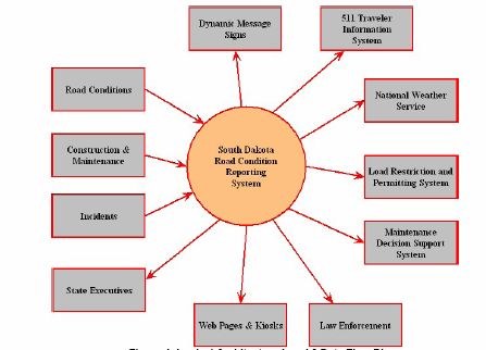
1. INTRODUCTION
This document is the product of Project 1.9 conducted as part of Phase-1 of the
North/West (N/W) Passage Corridor work plan. The N/W Passage corridor promotes
seamless traveler information along the I-90 and I-94 corridors from Wisconsin to
Washington state by emphasizing the coordination and integration of advanced traveler
information systems across state lines. Given the region’s long and sometimes severe winter
weather, traveler information is critical for ensuring the safety of the traveling public,
especially interstate travelers and commercial vehicle drivers.

Background

Several states along the I-90 and I-94 corridors have early on recognized the significant
benefits of Intelligent Transportation Systems (ITS) applications to road and weather
information delivery. Therefore, these states made modest to moderate investments in
weather sensors, traveler information hotlines (and later 511), Dynamic Message Signs
(DMS), and more recently; automated roadway/bridge treatment systems. In fact, the roots
of 511 could be traced back to a system that was deployed in North Dakota and South
Dakota in the late 1990s (#SAFE). Weather was the main focus of these early efforts.
Further, given the sporadic availability of ITS infrastructure, these efforts were not always
integrated into statewide systems that cover a wide range of traveler information. In
addition, there still remain some issues regarding the consistency and compatibility of
traveler information across state borders. The need to integrate these systems became
apparent as their potential for delivering useful, and often critical, traveler information was
better recognized.

Statewide road/weather condition reporting systems provide the means to collect, process,
share, and deliver a variety of information in real-time or close to real-time basis. Several
vendors developed and marketed early and proprietary road/weather condition reporting
systems. One of the first of the state systems was developed under the ITS operational
test/model deployment initiatives in Arizona in the mid 1990s. The system initially named
Trailmaster, computerized data collection and reporting along major roadways in Arizona.
Later the system was renamed as the Highway Condition Reporting System (HCRS). Soon
after that, several states initiated a pool fund study to customize the Arizona HCRS to their
respective needs. Over the years, other similar systems were developed, including
AASHTO’s Condition Acquisition and Reporting System (CARS).

While some states did approach the development of statewide condition reporting systems
as part of pooled fund studies, there was no single national standard for these systems.
Although the ITS Architecture provides a platform for planning these systems, the actual
designs were often influenced by the availability of ITS infrastructure (especially
communications) in each state. Therefore, vendor-specific (and to some extent, state
specific) approaches could best characterize the early development of these systems. This
resulted in little or no ability to seamlessly exchange information among different states
along the same corridor.

                                                                                                  1
New federal legislation (SAFETEA-LU) has been passed (August 2005) with the stated goal
“to provide the nationwide capability to monitor, in real-time, the traffic and travel
conditions of our nation’s major highways and to widely share that information to improve
the security of the surface transportation system, address congestion problems, support
improved response to weather events, and facilitate national and regional traveler
information.” (2) SAFETEA-LU includes provisions that address the development and
coordination of real-time system management information through better information
exchange formats. This really underlines the importance of multi-state coordination and the
increased benefits of having a nation-wide system of condition reporting systems. Clearly,
the N/W Passage Corridor is a significant step in the direction of realizing that national
vision. The details of these provisions are discussed in more detail under Section 4 of this
report.
Project Purpose/Objective
The initial purpose of this project was to develop a lessons learned document based on
deployment experiences of statewide condition reporting systems in North Dakota and one
in Wisconsin. The North Dakota Department of Transportation (NDDOT) was exploring
the possible deployment of Meridian’s statewide condition reporting system (later named
IRIS for Incident Reporting Information System) to further expand current traveler
information capabilities and support of North Dakota’s 511 system. Similarly, the Wisconsin
DOT (WisDOT) was in the initial planning stage of its 511 system with a vision that
includes partnering with the Wisconsin State Patrol for operating the underlying statewide
condition reporting system which would support 511. Therefore, WisDOT wanted to
demonstrate data entry requirements to the Wisconsin State Patrol for any condition
reporting system, using the CARS as an example. The Advanced Traffic Analysis Center
(ATAC) at North Dakota State University was to follow the deployment of the two systems
and develop a lessons learned document accordingly. In addition to the two case studies,
ATAC planned to develop brief information on other existing statewide condition reporting
systems, including their institutional arrangements, general data requirements, resources, etc.
After the start of the project, the NDDOT decided not to proceed with plans to deploy
Meridian’s statewide condition reporting system in North Dakota. This development greatly
reduced ATAC’s ability to study North Dakota’s deployment as a case study. ATAC staff
did, however, participate with demonstrations held for the NDDOT on the Meridian
system.
In Wisconsin, plans for a limited CARS deployment were proceeding well. However, CARS
itself was undergoing a major update in order to meet new NTCIP protocols. Therefore, the
new version of CARS differs from the old version, especially in terms of compatibility with
other systems. Nonetheless, some initial data were collected on Wisconsin’s experience with
CARS limited deployment.
After consulting with the project advisory panel, the following revised scope was developed
for this project:
1. Provide a description of new federal requirements for (real-time) statewide
information systems
22. Provide general descriptions of CARS, IRIS, and Arizona’s HCRS
3. Document Wisconsin’s CARS limited deployment
4. Review of South Dakota Department of Transportation’s (SDDOT) limited
Meridian condition reporting system deployment and study on improved road
condition reporting
5. Provide a current listing of state traveler information sources and contact
information
Report Organization
The remainder of this report is organized as follows:
Section 2 - Condition Reporting Systems: provides an overview on statewide condition
reporting systems, including general components of statewide information systems and brief
descriptions of HCRS, CARS, and IRIS.
Section 3 - Lessons Learned: summarizes results from Wisconsin’s DOT limited deployment
of CARS to illustrate data entry requirements, as well as findings from a South Dakota
DOT’s study of statewide condition reporting systems and an Arizona DOT study on ITS
data integration.
Section 4 –New Federal Requirements: briefly discusses recent provisions on real-time
system management information contained in the SAFETEA-LU transportation legislation.
Section 5 – Conclusions: provides a brief summary of findings.
Appendix A: Lists state traveler information sources online and provide a contact for each
listed state.
32. CONDITION REPORTING SYSTEMS
Information is often referred to as the “I” in ITS. Since the beginning of the ITS program,
there has been great emphasis on collecting information relevant to system operations,
processing that information, and distributing it. Recipients of this information include a
variety of transportation system users, as well as agencies responsible for operating the
system and responding to incidents or emergencies.
Traveler information can take a variety of formats and coverage depending on the
application and the area (i.e., metropolitan vs. rural or statewide). For statewide and rural
applications, these functions are generally included under the Pre-trip Travel Information
and En-route Driver Information user services. Pre-trip information is typically provided
through a web page or telephone interface. En-route information could be provided through
cellular or regular telephone, DMS, Highway Advisory Radio, and Kiosks.
This section provides a general discussion of statewide road condition reporting systems and
provides some examples. It discusses the general components of a statewide condition
reporting system. It also outlines the features of three existing condition reporting systems,
HCRS, CARS, and IRIS.
General Components
Regardless of the method used to deliver the information, the foundation of travel
information user services is a system which collects and processes information. Therefore, a
road condition reporting system must at least have a method for collecting data from the
field, processing the data into deliverable or value-added information, and finally either
directly or through an interface with a delivery system, distribute this information to various
users.
The scope and complexity of these components largely depend on the application and the
location. For large metropolitan areas or corridors with heavy traffic volumes, there is more
saturation of sensors, especially video. The availability of broadband communications is not
an issue. Information, including road weather conditions, is distributed to a diverse group of
users that may include private sector value-added information service providers. Figure 1
provides an illustration of this type of system. An Information Service Provider (ISP) in
Figure 1 handles most of value-added traveler information functions.
On the other hand, rural and statewide applications involve less saturation of sensors and
they must work with less communications coverage and bandwidth. The focus in these
systems emphasizes major incidents, due to weather or traffic crashes, as well as construction
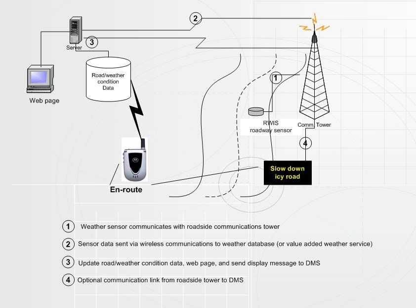
activity and other restrictions. Figure 2 shows an illustration of a predominantly weather
information system.
4Figure 1 Typical Components of a Travel Information System (1)
Figure 2 Typical Weather-based Travel Information System
5Data Collection
Collecting road condition data provides the foundation for any travel information system,
including road condition reporting systems. These condition data may include the
operational characteristics of the roadway (traffic), surface conditions and environmental
conditions, and incidents. A variety of devices and sensors depending on data types may be
used to collect, store, and/or transmit field data. In addition to field sensors, there are other
mechanisms to obtain information about the system operations, such as driver cellular calls
to 911, DOT crew reports, etc.
Manual data entry is common among various states for entering collected data and other
information for processing. However, several current efforts are targeting the automation of
these functions to reduce staff requirements, improve accuracy, and most importantly
enhance the timeliness of information.
Examples of data collection methods include:
1. Traffic
a. Loops
b. Video
c. Radar
d. Media
2. Weather
a. RWIS
b. Video
c. Law enforcement
d. Maintenance personnel
3. Incidents
a. Law enforcement
b. Travelers
c. Video
d. Homeland security sensors (i.e., HAZMAT detection)
Data Processing
After road and weather condition data are collected in the field, they are transmitted to a
processing system. Processing refers to converting raw data and field reports into a usable
format to support system operational decisions and to provide information to system users.
Depending on the application and the system design, processing may be done automatically
at pre-determined frequencies (i.e., update traffic speeds every 30 seconds) or as triggered by
certain events or sensor readings (i.e., temperature readings from a RWIS). The National ITS
Architecture provides the tools to define various user interfaces and the associated
processing required to support their information needs.
Processing may take place on-site in the field without operator or central system intervention
to support operations of roadway systems (i.e., RWIS data supports bridge automated anti-
icing treatment system and a DMS to warn drivers of icy conditions). A more common
arrangement is for field data to be sent to a central database for condition data. Generally,
these data exchange formats are covered by established ITS standards, namely National
Transportation Communications for ITS Protocol (NTCIP). The condition database may
6reside at a state agency responsible for operating the system or a private company under
contract to operate and support the system.
Information Distribution
After road and weather condition data been processed, information is distributed to travelers
as well as other centers or systems. A variety of methods may be used to deliver information
to pertinent users, including 511, web pages, HAR, and DMS. 511 is increasingly becoming a
major conduit for delivering information to the travelers and it serves as both a pre-trip and
as an en-route traveler information service. However, 511 systems have not been fully
implemented in all states. Figure 3 shows a status map of 511 system deployment. All but
three of the N/W Passage states have fully operational 511 systems. These systems are
generally owned and sponsored by state agencies.
Figure 3 Status of 511 Systems Deployment (Source FHWA)
In addition to the state-sponsored systems, private vendors often provide value-added and
tailored traveler information in select markets. They combine road and weather condition
information with video, media announcements, advertisements, and other services to
specific users and the general public.
7Communications
The successful deployment of any travel information system depends on the availability of
reliable communication links capable of carrying the required data at the desired frequency.
Communications play a major role in influencing statewide condition reporting systems,
influencing types of data, data formats, transmission frequency, accuracy, timeliness, and of
course deployment and operating costs of these systems. As more data collection and
transmission functions are automated and additional data (i.e., video) are added, the need for
faster and more reliable communications becomes even more critical. It should also be
mentioned that especially for statewide applications, there usually is a mix of
communications technologies that are utilized to support desired functions.
Summary
The concept of road condition reporting systems is fairly straightforward, i.e., collect data,
process data, and distribute information. However, the proper implementation of these
systems is not a trivial task. There are numerous institutional, financial, technological, and
technical issues that must be addressed. Given the diversity of sources of data and
information and the desire to share information and access among agencies, the
development of public-public and public-private partnerships is critical for success. Financial
factors influence the ability of the system to cover desired locations and functions. For
example, the number of sensors and the type of communications used are greatly influenced
by cost considerations. Among the top technological issues are the ability of automating data
collection and processing for various field devices and systems and the collection of data
from vehicle probes. States can greatly enhance their condition data if they can tap into data
from numerous public and private fleets as well as personal vehicles. Finally, technical issues
including standardization in order to ensure interoperability and seamless inter-jurisdictional
consistency are critical. National ITS Standards (i.e., NTCIP) provide the mechanisms for
ensuring such interoperability, while preserving enough flexibility for states to implement
systems that meet their unique needs.
To illustrate the impacts of these issues, Figure 4 and Figure 5 show two examples depicting
travel information systems in North Dakota and Minnesota. These figures present a
schematic illustration of data collection, processing, and distribution in the two states relative
to existing systems and users. It should be mentioned that although the two systems look
different, both states were successful in integrating their traveler information in order to
provide travelers on both sides of the border with relevant road and weather information.
This integration was largely possible because of the willingness among the state DOTs and
following ITS Standards for data exchange formats.
8Figure 4 NDDOT Travel Information System (Source: N/W Passage)
9Figure 5 Minnesota DOT Travel Information System (Source: N/W Passage)
10Existing Systems
The Highway Condition Reporting System (HCRS) developed in Arizona was among the
first statewide condition reporting systems. Soon after that, several states initiated a pool
fund study to customize the Arizona HCRS to their respective needs. Over the years, other
similar systems were developed, including AASHTO’s Condition Acquisition and Reporting
System (CARS). A third system was recently developed by Meridian Environmental
Technologies under the name Integrated Road Information System (IRIS).
The section provides a brief description of each system. It should be noted that
documentation on system components and design was hard to find. Therefore, the
researchers relied on documents as well as interviews to develop this information. As such,
the level of detail under each system’s description varies depending on available information.
HCRS
HCRS is a statewide data fusion system that Arizona Department of Transportation
(ADOT) developed in the mid-1990s principally as a means of coordinating the construction
and maintenance activities among various ADOT jurisdictions statewide (4). Originally,
HCRS stood for Highway Closure and Restriction System and later became Highway
Condition Reporting System. The AZDOT realized soon after the HCRS was developed
that there was great value in providing this information to the traveling public. Therefore, a
web page and an information hot line (prior to 511) were established to provide travelers
with access to the system.
HCRS has three main components: data collection, data processing, and data dissemination.
The system serves as the central data store for the collection and dissemination of
information (3). HCRS is widely and frequently used by ADOT staff. Data is manually
entered into HCRS at ADOT offices statewide over the Internet. Currently, information
from key fields in the HCRS form are automatically converted to synthesized speech
messages by means of a text-to-speech process and made available through the 511system
See Figure 6 and Figure 7 for more information on system components.
System Inputs
The HCRS uses traffic and weather information from a network of road/weather
information sensors, still-frame video cameras, and construction and maintenance crews
and patrols. Information is entered into HCRS via the Internet from HCRS workstations
located at ADOT facilities statewide, including in each of the nine ADOT District
Offices and field offices within each District (4). Other agencies can also enter
information into HCRS, including local traffic agencies and the Arizona Department of
Public Safety. As part of the I-40 Traveler and Tourism Information System deployment,
other emergency and tourist organizations and private event promoters could enter
information in the system.
HCRS data are entered using an Internet-based interface on an electronic on-screen
event form. Event data include various event attributes, such as location, type, etc. The
system stores the data using International Traveler Information Interchange Standard
“category” and “description” information. Recent upgrades to the system enhanced the
11location field entry by introducing a graphical user interface which allows users to click
on mileposts from a map to enter the location (5).
User Interfaces (System Outputs)
The two main outlets for travelers to access information from the HCRS are the Internet
and Arizona’s 511. The ADOT statewide web site provides real-time roadway condition
information. Using a state road map, users can click on a specific route and receive a list
of current roadway incident and construction information. Figure 8 shows a sample
screen shot of the ADOT web site.
Figure 6 Relationship of HCRS to Arizona's 511 (4)
12Figure 7 HCRS Components Overview as part of the I-40 ITIS (3)
13Figure 8 Arizona Traveler Information Web Site Using HCRS Information (4)
14CARS
The Condition Acquisition and Reporting System (CARS) was developed as part of a
FHWA Pooled Fund Study to customize Arizona’s HCRS and turn it into a commercial
product. Currently, CARS is non-proprietary and is owned by a consortium of states,
including the ten states of Alaska, Iowa, Kentucky, Maine, Minnesota, Missouri, New
Hampshire, New Mexico, Vermont, and Washington (6). These states also drive the ongoing
improvement and extension of the CARS system based on their needs and budgets.
Authorized users can enter, view and disseminate critical road, travel, weather, and traffic
information. CARS users access the system from any location using a standard web browser.
This allows users to enter any condition reports or view reports entered by any other users
around the state. The system provides for different user groups with different access levels
and each user is assigned a login and password. The access/security levels may all be
customized by system administrators of the state (7).
In order to keep CARS an open system that can be flexible enough to meet member state
needs while being able to interface with other ITS applications, it closely follows national
ITS standards. CARS uses Center to Center standards to send or receive incident data. It
also uses the national ERM model to transmit and receive data via XML, allowing it to be
integrated with other databases and information systems.
System Inputs
CARS data entry is performed manually through a web-based interface. This interface
greatly enhanced the system’s ability to receive data from as many authorized individuals
as possible. Events and situations are formulated according to the National Traffic
Management Data Dictionary (TMDD). Users may choose phrases already built intp the
system to expedite the data entry process and minimize errors (6). Event data entered
into the system include: construction, accidents, traffic, special events, and road weather
conditions. The system allows of automation of data collection from some ITS devices
to reduce data entry costs and time.
Information Display/Graphical Interface
CARS provides several options for displaying system information to travelers and system
users. A graphical display using a standard web browser provides a map with zoom
options to view a situation’s detailed information and location. Additionally, a text-based
display is also available. Figures 9 and 10 show examples of the two displays.
15Figure 9 CARS Graphical Situation Display (Source: (6))
Figure 10 CARS Text-Based Display (Source: (6))
16IRIS
The Integrated Road Information System (IRIS) was developed by Meridian Environmental
Technologies. Meridian has done pioneer work by developing traveler information systems
(#SAFE) in the states of North Dakota, Minnesota, and South Dakota in the late 1990s. The
development of IRIS came as a product of a study conducted for the SDDOT in 2001 (8).
In that study, a review of existing road reporting systems relative to SDDOT requirements
revealed the need for a new system. IRIS was therefore developed as an open-design client-
server system based on SQL.
The system consists of two major components, winter road conditions and construction
information. Information may be entered and accessed from various locations within the
state. Based on the organizational structure of the agency, the state may be divided into
smaller units. For example, in South Dakota, the state is divided into Regions, Areas, and
Shops.
System Inputs
Data entry to the system is accomplished through a graphical user interface for assigning
conditions. Winter road condition data include selected highways, conditions, and
duration. Construction data include: highway: designate the highway (and direction),
restrictions (list of restrictions is configurable and could contain items such as road
condition, routing, no passing, width height and weight limitations), and duration (start
time and end time for the construction event (9).
Figure 11 IRIS Graphical Data Entry Interface (8)
17The system authenticates the users through a login screen that requires a username and a
password. The system allows for a configurable number of user levels, each user level
will have different functionality and areas of the system that are available to them.
Generally, all users from different levels can view the information, however changing
and editing the information requires the user to be authorized (9). IRIS currently handles
only manual data input. No data is collected automatically from other systems (such as
RWIS).
System Architecture
The system has a central database which can reside at either Meridian or the agency
itself. Meridian uses a server with a pulling function where data are pulled from the
system every minute. A pushing system is being considered where the data will be
transferred to the server only when there is a change in conditions that warrants the
transfer. Communication between the clients and the server (database) is done over the
internet and some proprietary interface between the client and server. Meridian indicated
that bandwidth is not an issue since data are usually only several kilobytes that need to be
transferred at a given time and indicated that the system can be run over a dialup
modem. Figure 12 shows a general logical architecture of IRIS as it was envisioned for
the SDDOT.
Figure 12 IRIS Logical Architecture (8)
183. LESSONS LEARNED
This section provides more detailed information based on Wisconsin’s limited deployment
of CARS to illustrate data entry requirements, and information obtained from South Dakota
DOT ‘s deployment of IRIS, as well as an Arizona DOT study on ITS data integration.
Unfortunately, the IRIS deployment in North Dakota was postponed due to funding issues
and uncertainty with the new transportation bill. The NDDOT indicated a desire to wait for
federal requirements impacting incident reporting systems before embarking on IRIS’s
deployment (10). Therefore, information about IRIS is supplemented from a SDDOT study
which resulted in the development of the system.
The methodology for obtaining information about both systems relied on a questionnaire
developed by the ATAC research team that addressed several deployment aspects. Areas
covered in the questionnaire included:
1. System components
a. User interface:
b. Functionality:
c. Output
2. Data collection, entry, and storage
3. System requirements
a. Technical
b. Organizational/agency/financial
Figure 13 shows the full questionnaire.
CARS Limited Deployment in Wisconsin
The Project 1.2 of the N/W Passage aimed at testing the CARS system in Wisconsin
through a limited deployment. The trial was intended to demonstrate the system’s
requirements, especially staff requirements for data entry to the Wisconsin DOT (WisDOT)
and the Wisconsin State Patrol (WSP). It was envisioned that incident/event data entry into
CARS would be handled by WSP (11).
Using the CARS for this demonstration was for illustration purposes, i.e., the intent was to
give State Patrol dispatchers an idea of the level of effort that would be required to enter
events into any condition reporting system. It was also hoped that the WSP would see the
value of a centralized system to handle all incident and road condition information. The
demonstration took place along the I-94 corridor near the Minnesota/Wisconsin border at
Osseo, Wisconsin.
19Questions for Road Condition Reporting Systems
The purpose of these questions is to capture a snapshot of a road condition reporting system. Such information as
a description of the general functionality the system provides, a description of the user interface, and system
requirements both technical and organizational.
1. The system
a. User interface:
i. User Authentication
ii. Does the system provide for different user groups with different access levels?
iii. If the system allows different user groups, how many of them?
iv. Is the number of user groups built into the system or controlled by the end user?
v. Are the levels of access (the functionally each user group can access) built into the system for the
different user groups or customizable by the end user?
b. Functionality:
i. Components
1. Does the system provide for weather/winter road conditions?
2. What weather conditions are supported? Are they customizable for each agency?
3. Does the system provide construction information?
4. Traffic incidents information?
5. Security information?
ii. How are road segments identified? Mile posts? Other?
c. Output
i. How will the output be provided to the system users?
ii. How will the output be presented to the traveling public?
iii. Interfaces with other systems? (511, web, other condition reporting systems)
2. Data
a. What equipment/methods are used to enter data into the system?
i. Are Police departments and Highway Patrol mobile data systems supported? Or is communication
done through dispatch?
ii. Does the system support PDA type devices?
b. Who handles data entry?
c. Does the system have a mechanism to support getting data from motorists?
d. Where are the data housed?
i. Central database?
1. controlled by agency/ controlled by vendor?
ii. Distributed database?
iii. How are entries for the same event handled?
3. Requirements
a. Technical
i. What are the communication requirements of the system?
1. Client/server architecture
2. Bandwidth requirements
ii. What are the computing requirements of the system?
1. CPU speed/Computer memory?
2. Is the system PC based or other devices are supported?
3. PDA/Cell phones/Law enforcement mobile data systems?
iii. What is required before deployment of the system in terms of infrastructure of existing systems or
data
b. Organizational/Agency
i. What is required in terms of organizational requirement of the agency deploying the system
1. lead agency
2. agreements
3. access
4. funding
5. staffing
6. maintenance/operation
20Mn/DOT staff along with Castle Rock Consulting provided training to WSP dispatchers on
the use of CARS, including event data entry, viewing, and editing. A prototype of the CARS
system was configured and deployed for the demonstration including all roads in Wisconsin.
However, the test activity focused on the Eau Claire region. The trial began on November
15, 2004 and finished on December 15, 2004. During the test period, WSP dispatchers were
able to test the system by entering winter driving conditions, snowfall, crashes and other
relevant events (11). The system use was monitored during the one-month period, including
staff resource requirements, ease of use, and perceived value. System users were able to see
CARS output as it would appear to the travelers; however, there was no live broadcast of
information during the trial.
The results of the limited deployment were extremely positive, especially in alleviating
concerns about data entry resource requirements. The team made the following observations
at the conclusion of the trial (11):
1. Manual data entry would not be a burden for WSP dispatchers
2. WSP operators liked the idea of centralizing data entry and information distribution
to other agencies that need access to view the data (rather than sending data to
several particular agencies)
3. WSP operators felt the system was easy and quick to use
4. The WSP noted that uptime of the system and the availability of 24 hour support
was an important criteria to be considered if and when WisDOT/WSP pursue full
deployment
SDDOT Study
The SDDOT study on improving road condition reporting systems was not initially part of
this project scope (8). However, it was felt that the study’s final report provided some
valuable insights that could apply to any state and fit well with the lesson-learned theme of
this project.
Perhaps one of the first observations from the SDDOT study is the diversity of stakeholders
involved in making a decision regarding a state’s choice of a condition reporting system. In
addition to traditional DOT involvement, state patrol or other law enforcement agencies
have an increasing role in supporting condition reporting systems. These agencies provide
the much needed operational staff support which may not be available at the DOT. Another
agency that could have a crucial role in a condition reporting system implementation is a
state IT department. In South Dakota, the Bureau of Information and Telecommunications
(SDBIT). The SDBIT had technical requirements in regards to the system design, specifically
using SQL Server protocols.
Another observation from the SDDOT experience was that the value of information to
travelers and system users was greatly influenced by the timeliness and accuracy of the
system. These two system attributes are however impacted by the data collection/entry
method. Manual data entry requires more resources and could result in significant delay in
entering and displaying event information. This limitation may be addressed by automation
21and/or by increasing the number of data entry operators by utilizing other agency staff (i.e.,
law enforcement and emergency management). It should be further noted that automation
does not have to be an all-or-nothing provision. There are opportunities to improve system
performance by partial automation from ITS devices which could provide automated data.
Finally, the use of ITS standards once again was emphasized as a critical factor of success for
the development of any condition reporting systems (and other ITS as well). The SDDOT
approach proved effective by developing a criteria based on a wide representation of
stakeholders, thus recognizing the unique needs/circumstances of South Dakota, and closely
following national ITS standards.
Arizona ITS Data Integration
Although this project was not specific to condition reporting systems, it did address some
relevant issues concerning HCRS. The Arizona Department of Transportation (ADOT)
recognized the fragmentation of various traffic ITS data and therefore conducted an ITS
Traffic Data Consolidation System study (5). ADOT maintains a variety of independent ITS
applications to monitor and manage roadway conditions and events across the state. Data
from these systems include traffic counts, weather, pavement conditions, signal timing, and
DMS text, camera images.
Each of these ITS applications has its own unique user interface, security, output data
format, and task initiation timetable. The first phase of this project provided access for
HCRS users and website visitors to VMS sign messages, Closed Circuit Television (CCTV)
roadway images, sensor data from Road Weather Information Systems (RWIS), and National
Weather Service (NWS) forecasts and advisories (5).
The second phase of the project addressed improvements to HCRS’s data entry interface.
System users are now able to enter highway mileposts graphically, greatly simplifying field
data entry and improving location accuracy. In addition, numerous redundant display layers
and icons were removed or simplified (15).
Some of the issues identified from this integration project included (5):
1. Difficulty of integrating third-party data (DMS and RWIS)
2. The amount of data archived by the HCRS became an issue Therefore, a storage
capacity analysis should have been done prior to system integration
3. There needs to be a process for adding new road sections and integrating these
sections into the system’s GIS database.
4. Inclusion of more information into the HCRS, including rural travel prediction based
on road/weather conditions.
4. NEW FEDERAL REQUIREMENTS
22The Federal Highway Administration (FHWA) and the USDOT ITS Joint Program Office
(IJPO) have long been advocates of advancing travel information to reduce delay and
enhance safety. Therefore, Transportation System Management and Operations
Information has increasingly been the focus of the national ITS program as a new era
following system construction and preservation. ITS is an integral part of this focus labeled
“21st Century Operations Using 21st Century Technology.” (FHWA)
Real-time information availability is viewed by FHWA and the IJPO as the foundation of
system management and operations. As a result, there are several new provisions in the
recently passed “Safe, Accountable, Flexible, Efficient Transportation Equity Act: A Legacy
for Users’’ (SAFETEA–LU) to promote the development of real-time information systems
to support management and operations. Most notable among these provisions is included
under Subtitle B Congestion Relief in Sec. 1201 which establishes a Real-Time System
Management Information Program. The purpose of this program includes three main
components (2):
1. Establish, in all states, a system of basic real-time information for managing and
operating the surface transportation system
2. Identify longer range real-time highway and transit monitoring needs and develop
plans and strategies for meeting such need
3. Provide the capability and means to share that data with state and local governments
and traveling public
This section calls for the U.S. DOT to establish data exchange formats no later than two
years of the enactment of TEA LU (i.e., by August 10, 2007). These data formats will ensure
that the data provided by highway and transit monitoring systems, including statewide
incident reporting systems, can be readily exchanged to facilitate nationwide availability of
information. However, this section does not include a specific date for states and local
governments to develop new real-time system management information or incorporate data
exchange formats into existing systems.
As State and local governments develop or update regional ITS architectures, they must
explicitly address real-time highway and transit information needs and the systems needed to
meet such needs, including addressing coverage, monitoring systems, data fusion and
archiving, and methods of exchanging or sharing highway and transit information (2). Once
again, there is no specific date for meeting this requirement since the deadline targeted for
the Regional ITS Architecture Conformity Rule expired as of April 2005. Additionally, this
rule does not have a specific requirement as to the frequency or scheduling of architecture
updates.
No separate funds were allocated for developing and supporting this program. However,
states may use their National Highway System (NHS), Congestion Mitigation and Air
Quality Improvement (CMAQ), and Surface Transportation Program (STP) funds for these
activities.
235. CONCLUSIONS
This study developed information on condition reporting systems from a variety of sources,
including review of existing condition reporting systems, available documentations, and
interviews with system integrators and agency staff. Below are some of the major
observations:
1. Integration of condition reporting systems with other existing state systems
continues to be an issue. This not only influences the system’s ability to widen its
potential users, but also how data are exchanged, including ITS data automation.
2. Manual data entry is the general practice for current condition reporting systems.
Such an arrangement could greatly impact the level of resources required for
successfully operating the system as well as the value to travelers in terms of
timeliness and accuracy of information. However, state DOT agencies should
explore sharing the system with other agencies to increase the number of operators
with data entry privileges. This is especially true for law enforcement/emergency
management agencies which generally have longer operating hours and are most
familiar with incidents and other events affecting system operations.
3. Database housing, management, and maintenance must be examined prior to system
implementation. There could be additional restriction if the database is housed at a
state agency by its respective IT department.
4. Integration/coordination between/among neighboring states’ condition reporting
systems is key to ensure seamless service to the traveler. Of course this requires
compatibility among the various systems and protocols for exchanging information.
Related to this issues are national ITS standards and possible guidelines through the
proposed federal requirements for incident reporting systems.
5. There may yet be great opportunities to expand the use of road condition reporting
systems to other agencies, especially law enforcement and local jurisdictions.
6. There is an increased focus on real-time information as part of a larger emphasis on
operations and customer service. The traveling public’s appetite for information is
expected to only grow. With that there is an opportunity for delivering information
in a variety of methods as more users have access to the Internet as well as other
personal communication devices.
7. New federal requirements for developing real-time information and management
systems were watched closely by the states. The final language in SAFETEA-LU
requires the U.S. DOT to develop data exchange formats for these systems no later
than August 2007. Additionally, areas developing or updating their regional ITS
architectures must explicitly address real-time highway and transit information needs
and the systems needed to meet such needs.
8. The North/West Corridor Pooled Fund Study states are well positioned to provide a
positive example of how states can work together in streamlining road and weather
condition data across their borders. These states recognized the value of
coordination and integration long before the passage of SAFETEA-LU and its
provisions for real-time system management. Further, the output of the strategic
plan and corridor architecture to be undertaken in Phase II of the North/West
Passage should provides valuable insights to the U.S. DOT and other states.
24REFERENCES
1. U. S. Department of Transportation, Developing Traveler Information Systems Using the
National ITS Architecture, Intelligent Transportation Systems Joint Program Office
August 1998
2. U.S. House of Representatives web page
(http://www.house.gov/rules/109textTEALU.htm)
3. Federal Highway Administration, Evaluation Plan: The I-40 Traveler and Tourist
Information System Field Operational Test, Report # FHWA-JPO-99-028, ITS Joint
Program Office, FHWA, U.S. Department of Transportation, 1998
4. Federal Highway Administration, Interim Analysis Report Model Deployment of a Regional,
Multi-Modal 511 Traveler Information System, ITS Joint Program Office, U.S.
Department of Transportation, 2004
5. Arizona Department of Transportation, ITS Traffic Data Consolidation System, Report
# FHWA-AZ-05-512, 2005
6. CARS program web site: http://www.carsprogram.org/public/overview.htm
7. Questionnaire responses by Dean Deeter, Castle Rocks Consultants.
8. South Dakota Department of Transportation, Improved Road Condition Reporting,
Report # SD2001-15-F, 2004
9. Interview and questionnaire, Mark Owens, Meridian Environmental Technologies,
2004
10. Interview with Ed Ryen, NDDOT, 2005
11. North/West Passage Transportation Pooled Fund Study, Deploy Limited CARS Study
Application in Wisconsin: Project Recap and Lessons Learned, Phase I Project 1.2, 2005
25APPENDIX A
COMPLILATION OF STATE TRAVELER INFORMATION
WEB SITES AND CONTACT INFORMATION FOR
MAINTENANCE/OPERATIONS ENGINEERS
26DOT Traveler Information
ALABAMA ALDOT Travel Information
John E. Lorentson http://www.dot.state.al.us/docs/travel
Maintenance Engineer
Department of Transportation Weather Information
1409 Coliseum Boulevard http://www.srh.noaa.gov/
Montgomery, AL 36110
334-242-6272 Emergency Road Closures
FAX: 334-242-6378 http://www.srh.noaa.gov/
Email: lorentsonj@dot.state.al.us
ALASKA Alaska 511
Frank Richards http://511.alaska.gov/
State Maintenance Engineer
Department of Transportation and Public Highways
Facilities http://511.alaska.gov/routeSelect.asp
3132 Channel Drive
Juneau, AK 99801 Road Weather Information System
907-465-3906 http://www.dot.state.ak.us/iways/roadweat
FAX: 907-465-2021 her/index.shtml
Email: frank_richards@dot.state.ak.us
Road Weather
Alaska Traveler Information http://www.dot.state.ak.us/iways/roadweat
http://www.dot.state.ak.us/traveler.shtml her/rwis_geo_index.shtml
ARIZONA
James Dorre Traffic
State Maintenance Engineer http://www.az511.com/RoadwayCondition
Department of Transportation s/index.php
206 S. 17th Avenue, MD176A
Phoenix, AZ 85007-3213 Closures and Restrictions
602-712-7949 http://www.az511.com/hcrsweb/hcrsweb.j
FAX: 602-712-6745 sp
Email: jdorre@dot.state.az.us
Cameras
Arizona 511 http://www.az511.com/CameraImages/ind
http://www.az511.com/ ex.php
27ARKANSAS
Leonard Hall
State Maintenance Engineer Road Conditions
Highway and Transp. Department http://www.ahtd.state.ar.us/Roads/roads.ht
P. O. Box 2261 m
Little Rock, AR 72203-2261
501-569-2231
FAX: 501-569-2014
Email: leonard.hall@ahtd.state.ar.us
CALIFORNIA
Steve Takigawa Highway Conditions
State Maintenance Engineer http://www2.dot.ca.gov/hq/roadinfo/
Department of Transportation
1120 N Street MS 31
Sacramento CA 95814 Real Time Traffic Incidents
916-654-5849 http://cad.chp.ca.gov/
FAX: 916-654-6608
Email: steve.takigawa@dot.ca.gov
Traffic Updates
Roads and Traffic http://www.commutesmart.info/traffic
http://www.dot.ca.gov/roadsandtraffic.htm updates/index.html
COLORADO
Wayne Lupton Traveler Information
Staff Maintenance Superintendent http://www.dot.state.co.us/TravelInfo/
Department of Transportation
15285 South Golden Rd., Bldg. #45 Road Condition Information
Golden, CO 80401 http://www.cotrip.org/rWeather/All_Regio
303-273-1840 ns_021605_103639.html
FAX: 303-273-1854
Email: wayne.lupton@dot.state.co.us Alerts and Restrictions
http://www.cotrip.org/rWeather/All_Alerts
_021605_103639.html
Current Conditions
http://www.dot.state.co.us/TravelInfo/Cur
rentCond/
28CONNECTICUT Travel Information
Robert P. Mongillo http://www.ct.gov/dot/taxonomy/ct_taxo
Trans. Maintenance Administrator nomy.asp?DLN=40008&dotNav=|40008|
Department of Transportation
PO Box 317546 Traffic Cameras
2800 Berlin Turnpike http://www.conndot.ct.gov/cams/trafficca
Newington, CT 06131-7546 m.aspx?dotPNavCtr=|#40163
860-594-2604
FAX: 860-594-2655 Current Traffic Incidents
Email: robert.mongillo@po.state.ct.us http://www.conndot.ct.gov/traffic/traffic_i
ncidents.aspx?dotPNavCtr=|#40196
DELAWARE Travel Information
Maria Fantini http://www.deldot.net/static/travel.html
District Maintenance Engineer
Department of Transportation Travel Advisories
800 S. Bay Road http://www.deldot.net/public.ejs?command
Dover, DE 19901 =PublicTrafficReportDisplay
302-760-2438
FAX: 302-760-2471 Email Traffic Updates
Email: mfantini2@mail.dot.state.de.us http://www.deldot.net/mydeldot.ejs
FLORIDA Traveler Information
Sharon Holmes http://www.dot.state.fl.us/publicinformatio
State Maintenance Engineer noffice/traveler.htm
Department of Transportation
605 Suwannee Street MS-52 Florida Traffic
Tallahassee, FL 32399-0450 http://www.fhwa.dot.gov/trafficinfo/fl.htm
850-488-8814
FAX: 850-488-4418 511 Tampa Bay Area
Email: sharon.holmes@dot.state.fl.us http://www.511tampabay.com/
511 South Florida
http://host.maptuit.com/fdot/?config=Traf
ficW.FDOT&aoi=8
29GEORGIA
Bryant Poole Georgia Traffic
State Maintenance Engineer http://www.georgia-navigator.com/
Department of Transportation
935 East Confederate Ave, Bldg. 24
Atlanta, GA 30316
404-656-5314
FAX: 404-657-7286
Email: bryant.poole@dot.state.ga.us
HAWAII Traffic Incidents and Information
Martin Okabe http://www4.co.honolulu.hi.us/hpdtraffic/
State Const. & Maint. Engineer
Dept. of Trans. - Highway Division Honolulu Traffic Cameras
869 Punchbowl Street, Room 203 http://www.co.honolulu.hi.us/cameras/traf
Honolulu, HI 96817 fic.htm
808-587-2185
FAX: 808-587-2340 Live Fast Traffic Cameras
Email: martin.okabe@hawaii.gov http://www.co.honolulu.hi.us/cameras/hot
_spot.htm
IDAHO
Dave Jones Traveler Services
State Maintenance Engineer http://itd.idaho.gov/Apps/RoadReport/
Idaho Transportation Department
P.O. Box 7129 Weather and Pavement Conditions
Boise, ID 83707
208-332-7893 http://itd.idaho.gov/Apps/RWIDS_Pu
FAX: 208-334-8595 blic/default.asp
Email: djones@itd.state.id.us
ILLINOIS
Joe Hill Chicago Expressway Congestion Maps
Engineer of Operations
Department of Transportation http://www.gcmtravel.com/gcm/maps
2300 S. Dirksen Parkway, Rm. 009 _chicago.jsp
Springfield, IL 62764
217-782-7231
FAX: 217-782-1927
Email: hilljs@nt.dot.state.il.us
30INDIANA
Mike Bowman NW Indiana Traffic Conditions
Highway Support Manager http://pws.indot.org/pws/nw
Department of Transportation
100 N. Senate Avenue, Room N925
Indianapolis, IN 46204-2217 RWIS
317-232?5508
FAX: 317-232-5551 http://webservices.indot.state.in.us/RW
Email: mbowman@indot.state.in.us IS/#
IOWA
Lee Wilkinson Iowa 511
Department of Transportation http://www.511ia.org/
800 Lincoln Way
Ames, IA 50010
515-239-1971
FAX: 515-239-1766
Email: lee.wilkinson@dot.state.ia.us
KANSAS
Dean M. Testa Kansas 511
Chief, Bureau of Const. & Maint. http://511.ksdot.org/kanroadpublic/Ks
Department of Transportation ys/KRDefault.asp
915 Harrison—Room 881
Topeka, KS 66612-1568
785-296-3576
FAX: 785-296-6944
Email: dean@ksdot.org
KENTUCKY
Tom Schomaker, 511 Kentucy
Director of Maintenance http://mapclient.kytc.state.ky.us/default.asp
Transportation Cabinet ?display=critical&area=statewide&tex
State Office Building - 3rd Floor
Frankfort, KY 40622
502-564-4556
FAX: 502-564-6640
Email: tom.schomaker@ky.gov
31LOUISIANA
Gill Gautreau
Structure & Facilities Maint. Engineer
Dept. of Trans. and Development Traveler Information
P.O. Box 94245 http://www.dotd.state.la.us/press/traffic_ca
Baton Rouge, LA 70804-9245 meras/traffic.asp?page=home
Phone: 225-379-1551
FAX: 225-379-1853
Email: ggautreau@dotd.louisiana.gov
MAINE
Roger Gobeil
Director, Bureau of Maint. & Ops.
Department of Transportation
Transportation Building
Augusta, ME 04333 511 Maine
207-624-2600 http://67.106.3.239/
FAX: 207-623-2526
Email: roger.gobeil@maine.gov
MARYLAND
Russell A. Yurek
Deputy Chief Engr. - Maintenance Chart
State Highway Administration http://www.chart.state.md.us/
7491 Connelley Drive
Hanover, MD 21076
410-582-5505
FAX: 410-582-9861
Email: ryurek@sha.state.md.us
MASSACHUSETTS
Gordon A. Broz
Deputy Chief Engineer of Highway Ops.
Massachusetts Highway
10 Park Plaza
Boston, MA 02116-3973
617-973-7741
FAX: 617-973-8037
32MICHIGAN
Engineer of Maintenance
Department of Transportation
6333 Old Lansing Road
Lansing, MI 48917
517-322-3333
FAX: 517-322-2699
Email: robertsc@mdot.state.mi.us
MINNESOTA
Mark Wikelius Minnesota 511
State Maintenance Engineer http://www.511mn.org/
Dept of Transportation, MS-700
395 John Ireland Blvd.
St. Paul, MN 55155-1899
651-297-3590
FAX: 651-297-7576
Email: mark.wikelius@dot.state.mn.us
MISSISSIPPI
John Vance Mississippi Traffic
State Maintenance Engineer http://www.mstraffic.com/
Department of Transportation
P.O. Box 1850
Jackson, MS 39215-1850
601-359-7111
FAX: 601-359-7126
Email: jvance@mdot.state.ms.us
MISSOURI
James Carne Statewide Road Conditions and Work
State Maintenance Engineer Zones
Department of Transportation
P.O. Box 270 http://www.modot.state.mo.us/road_co
Jefferson City, MO 65102 nditions/index.htm#
573-751-8648
FAX: 573-526-4868
Email: carnej@mail.modot.state.mo.us
33You can also read