Calumet County Land Information Plan 2019-2021
←
→
Page content transcription
If your browser does not render page correctly, please read the page content below
Calumet County
Land Information Plan
2019-2021

**Wisconsin Land Information Program
  Wisconsin Department of Administration
  101 East Wilson Street, 9th Floor
  Madison, WI 53703
  (608) 267-3369
  www.doa.wi.gov/WLIP
Version: 2018-10-03
Approved/Adopted by Land Information Council on: 2018-**-**
CONTENTS
_

EXECUTIVE SUMMARY ........................................................ 3
1 INTRODUCTION .............................................................. 5
2 FOUNDATIONAL ELEMENTS .......................................... 8
    PLSS .............................................................................................................................. 9
    Parcel Mapping ......................................................................................................... 10
    LiDAR and Other Elevation Data ............................................................................ 12
    Orthoimagery............................................................................................................ 13
    Address Points and Street Centerlines................................................................... 14
    Land Use .................................................................................................................... 16
    Zoning ........................................................................................................................ 16
    Administrative Boundaries ...................................................................................... 18
    Other Layers .............................................................................................................. 20

3 LAND INFORMATION SYSTEM ..................................... 22
    Public Access and Website Information ................................................................ 26

4 CURRENT & FUTURE PROJECTS .................................. 28
    Project #1: Bridge and Culvert Survey ................................................................... 29
    Project #2: PLSS Mapping, Monumentation, and Maintenance ......................... 29
    Project #3: Website Update .................................................................................... 30
    Project #4: Staff Development and Training ........................................................ 30
    Project #5: Election Reporting System .................................................................. 31
    Project #6: GIS Hardware Update........................................................................... 31
    Project #7: Re-Index and Publish Permit Records Online ................................... 32
    Project #8: Orthophotography ............................................................................... 32
    Project #9: Publish ROD Documents Online ......................................................... 33
    Project #10: LiDAR Acquisition ............................................................................... 33

                                                                                                                                            2
EXECUTIVE SUMMARY
About this Document. This document is a land information plan for Calumet County prepared by
the Land Information Officer (LIO) and the land information council. By Wisconsin statute, “a countywide
plan for land records modernization” is required for participation in the Wisconsin Land Information
Program (WLIP). The purpose of this document is twofold: 1) to meet WLIP funding eligibility
requirements necessary for receiving grants and retaining fees for land information, and 2) to plan for
county land records modernization in order to improve the efficiency of government and provide
improved government services to businesses and county residents.
WLIP Background. The WLIP, administered by the Wisconsin Department of Administration, is
funded by document recording fees collected by the register of deeds at the county-level. In 2017,
Calumet County received $1,000 in WLIP training and education grants and $28,728 in base budget grants
and retained a total of $71,272 in local register of deeds document recording fees for land information.
Calumet County also received $50,000 in Strategic Initiative Grant funds.
This plan lays out how funds from grants and retained fees will be prioritized. However, as county budgets
are determined on an annual basis with county board approval, this plan provides estimated figures that
are subject to change and are designed to serve planning purposes only.
Land Information in Calumet County. Land information is central to county operations, as many
essential services rely on accurate and up-to-date geospatial data and land records. A countywide land
information system supports economic development, emergency planning and response, and a host of
other citizen services. The Calumet County land information system integrates and enables efficient access
to information that describes the physical characteristics of land, as well as the property boundaries and
rights attributable to landowners.
Mission of the Land Information Office. In the next three years, Calumet County’s Land
Information Office strives to be recognized for its exceptional webmapping site, gains in governmental
efficiencies by broadening the utilization of GIS, improvements in parcel mapping accuracy, and
responsiveness to meeting the land records needs of residents and businesses.
Land Information Office Projects. To realize this mission, in the next three years, the county land
information office will focus on the following projects:
Calumet County Land Information Projects: 2019-2021
Project #1 Bridge and Culvert Survey
Project #2 Maintain PLSS remonumentation with survey grade GPS coordinates
Project #3 Website Update
Project #4 Staff Development and Training
Project #5 Election Reporting System
Project #6 GIS Hardware Update
Project #7 Re-index and Publish Permit Records Online
Project #8 Orthophotography
Project #9 Full SSN redaction and online integration and availability of ROD documents
Project #10 LiDAR Acquisition
3The remainder of this document provides more details on Calumet County and the WLIP, summarizes
current and future land information projects, and reviews the county’s status in completion and
maintenance of the map data layers known as Foundational Elements.
41 INTRODUCTION
In 1989, a public funding mechanism was created whereby a
portion of county register of deeds document recording fees
collected from real estate transactions would be devoted to land
Any physical, legal, economic or
information through a new program called the Wisconsin Land environmental information or
Information Program (WLIP). The purpose of the land information characteristics concerning land,
plan is to meet WLIP requirements and aid in county planning for water, groundwater, subsurface
land records modernization. resources or air in this state.
The WLIP and the Land Information Plan ‘Land information’ includes
information relating to
Requirement topography, soil, soil erosion,
In order to participate in the WLIP, counties must meet certain geology, minerals, vegetation,
requirements: land cover, wildlife, associated
• Update the county’s land information plan at least every natural resources, land
three years ownership, land use, land use
• Meet with the county land information council to review controls and restrictions,
jurisdictional boundaries, tax
expenditures, policies, and priorities of the land
assessment, land value, land
information office at least once per year
survey records and references,
• Report on expenditure activities each year geodetic control networks, aerial
• Submit detailed applications for WLIP grants photographs, maps, planimetric
• Complete the annual WLIP survey data, remote sensing data,
• Subscribe to DOA’s land information listserv historic and prehistoric sites and
• Coordinate the sharing of parcel/tax roll data with the economic projections.
Department of Administration in a searchable format – Wis. Stats. section 59.72(1)(a)
determined by DOA under s. 59.72(2)(a)
Any grants received and fees retained for land information through the WLIP must be spent consistent
with the county land information plan.
Act 20 and the Statewide Parcel Map Initiative
A major development for the WLIP occurred in 2013 through the state budget bill, known as Act 20. It
directed the Department of Administration (DOA) to create a statewide digital parcel map in coordination
with counties.
Act 20 also provided more revenue for WLIP grants, specifically for the improvement of local parcel
datasets. The WLIP is dedicated to helping counties meet the goals of Act 20 and has made funding
available to counties in the form of Strategic Initiative grants to be prioritized for the purposes of
parcel/tax roll dataset improvement.
For Strategic Initiative grant eligibility, counties are required to apply WLIP funding toward achieving
certain statewide objectives, specified in the form of “benchmarks.” Benchmarks for parcel data—
standards or achievement levels on data quality or completeness—were determined through a
participatory planning process. Current benchmarks are detailed in the WLIP grant application, as will be
future benchmarks.
WLIP Benchmarks (For 2016-2018 Grant Years)
• Benchmark 1 & 2 – Parcel and Zoning Data Submission/Extended Parcel Attribute Set Submission
• Benchmark 3 – Completion of County Parcel Fabric
• Benchmark 4 – Completion and Integration of PLSS
5More information on how Calumet County is meeting these benchmarks appears in the Foundational
Elements section of this plan document.
County Land Information System History and Context
Calumet County has been working on land records modernization in some form or another since 1972
when the County Board of Supervisors authorized the remonumentation program. From there the County
started parcel mapping efforts in 1974 and made strides in modernization throughout the 1980’s. Once
the WLIP was established in 1989 the County established the Land Information Committee which
successfully applied for grants to complete remonumentation and GPS a large portion of the County. By
the mid-1990’s the Land Information Office had established a considerable foundation and hired a
mapping technician in 1996 who was largely tasked with digitizing data into a more modern GIS format.
In 1999 a new GIS Administrator was hired and a revitalized effort was underway to acquire new data and
get established data into a more standardized maintenance schedule. Soon the workload necessitated a
second GIS staff person and in 2002 a GIS Specialist was added to the Land Information Office. By 2007
the department was reduced to just the GIS Administrator but all of the parcels were digitally mapped, the
PLSS remonumentation program was on a 20 year maintenance cycle, aerial imagery acquisition was on a
5 year cycle, GIS data was freely available through online mapping portals, Enhanced 911 was fully
integrated with GIS emergency district and street centerline data and operating as part of a local
consortium, and nearly all Register of Deeds documents were scanned and indexed. In 2011 and 2012 the
Land Information Office transitioned all GIS data into an enterprise database management system which
increased efficiency, accuracy, and data availability. A year later the Register of Deeds office implemented
a new records management system that revamped the entire office and allowed more universal access to
ROD documents.
County Land Information Plan Process
County land information plans were initially updated every five years. However, as a result of Act 20,
counties must update and submit their plans to DOA for approval every three years. The 2019-2021 plan,
completed at the end of 2018, is the second post-Act 20 required update.
Plan Participants and Contact Information
Another requirement for participation in the WLIP is the county land information council, established by
legislation in 2010. The council is tasked with reviewing the priorities, needs, policies, and expenditures of
a land information office and advising the county on matters affecting that office.
According to s. 59.72(3m), Wis. Stats., the county land information council is to include:
• Register of Deeds
• Treasurer
• Real Property Lister or designee
• Member of the county board
• Representative of the land information office
• A realtor or member of the Realtors Association employed within the county
• A public safety or emergency communications representative employed within the county
• County surveyor or a registered professional land surveyor employed within the county
• Other members of the board or public that the board designates
The land information council must have a role in the development of the county land information plan,
and DOA requires county land information councils to approve final plans.
6This plan was prepared by the county LIO, the Calumet County Land Information Council, and others as
listed below.
Plan Designer
Andy Hess, GISP (LIO) Phone: 920-849-2361 ext 2302
GIS Administrator E-Mail: Andy.Hess@calumetcounty.org
Calumet County Land Information Office Website: www.calumetmaps.com
Calumet County Land Information Council and Plan Workgroup
Name Title Affiliation Email Phone
+ Tami Alten Register of Deeds Calumet County tami.alten@calumetcounty.or 920-849-2361
Register of Deeds Office g x3101
+ Mike Schlaak County Treasurer Calumet County mike.schlaak@calumetcounty. 920-849-2361
Treasurer’s Office org x3201
+ Marissa Heimerl Real Property Lister Calumet County Treasurer’s marissa.heimerl@calumetcou 920-849-2361
Office nty.org x3202
+ Matthew Budde County Board Member County Board Member matthew.budde@calumetcou 920-849-2361
nty.org
+ Andy Hess GIS Administrator, Planning, Zoning, and Land andy.hess@calumetcounty.or 920-849-1442
Land Information Officer Information Department g x 2302
+ Jerry Thiel Realtor Thiel Real Estate tamarat@thielrealestateandau 920-849-2222
ctions.com
+ Bernie Sorenson Emergency Management Calumet County Emergency bernie.sorenson@calumetcou 920-849-2361
Director Management nty.org x5401
+ Brad Buechel County Surveyor Meridian Surveying LLC bbuechel@meridian-wi.com 920-993-0881
+ Todd Romenesko County Administrator County Administrator todd.romenesko@calumetcou 920-849-2361
nty.org x2002
+Matt Payette Planning, Zoning, and Land Planning, Zoning, and Land matt.payette@calumetcounty. 920-849-2361
Information Director Information org x 2306
+Tony Reali County Conservationist Land & Water Conservation anthony.reali@calumetcounty. 920-849-2361
Department org x2406
+Dan DeBonis Finance Director Finance Department dan.debonis@calumetcounty. 920-849-2361
org x2104
+Howard Mezera Information Technology Information Technology howard.mezera@calumetcoun 920-849-2361
Director Department ty.org x2505
+John Anderson Network Administrator Information Technology john.anderson@calumetcount 920-849-2361
Department y.org x2504
+Mark Mommaerts Town & Village Planner Town & Village of Harrison mmommaerts@townofharriso 920-989-1062
n.org
+Jim Mayer Surveyor Mayer Land Surveying jmayer8@new.rr.com 920-439-1761
+Mike Zuege GIS Coordinator East Central Regional mzuege@ecwrpc.org 920-886-6815
Planning Commission
+ Land Information Council Members designated by the plus symbol
72 FOUNDATIONAL ELEMENTS
Counties must have a land information plan that
addresses development of specific datasets or map layer
groupings historically referred to as the WLIP
Foundational Elements. Foundational Elements PLSS
incorporate nationally-recognized “Framework Data” Parcel Mapping
LiDAR and Other Elevation Data
elements, the major map data themes that serve as the
Orthoimagery
backbone required to conduct most mapping and Address Points and Street Centerlines
geospatial analysis. Land Use
Zoning
In the past, Foundational Elements were selected by the Administrative Boundaries
former Wisconsin Land Information Board under the Other Layers
guiding idea that program success is dependent upon a
focus for program activities. Thus, this plan places priority
on certain elements, which must be addressed in order for a county land information plan to be approved.
Beyond the county’s use for planning purposes, Foundational Element information is of value to state
agencies and the WLIP to understand progress in completion and maintenance of these key map data
layers.
8PLSS
Public Land Survey System Monuments
Layer Status
PLSS Layer Status
Status/Comments
Number of PLSS corners (selection, ¼, meander) set in • 1813
original government survey that can be remonumented in
your county
Number and percent of PLSS corners capable of being • 1813 – 100%
remonumented in your county that have been
remonumented
Number and percent of remonumented PLSS corners with • 1813 – 100% survey grade coordinates
survey grade coordinates (see below for definition)
• SURVEY GRADE – coordinates collected under the
direction of a Professional Land Surveyor, in a
coordinate system allowed by 236.18(2), and obtained
by means, methods and equipment capable of
repeatable 2 centimeter or better precision
• SUB-METER – point precision of 1 meter or better
• APPROXIMATE – point precision within 5 meters or
coordinates derived from public records or other
relevant information
Number and percent of survey grade PLSS corners • 1813 – 100%
integrated into county digital parcel layer
Number and percent of non-survey grade PLSS corners • 0 – 0%
integrated into county digital parcel layer
Tie sheets available online? • Yes - http://calumetcowi.wgxtreme.com/
Percentage of remonumented PLSS corners that have tie • 100%
sheets available online (whether or not they have
corresponding coordinate values)
Percentage of remonumented PLSS corners that have tie • 0%
sheets available online (whether or not they have
corresponding coordinate values) and a corresponding
URL path/hyperlink value in the PLSS geodatabase
PLSS corners believed to be remonumented based on filed • 0
tie-sheets or surveys, but do not have coordinate values
Approximate number of PLSS corners believed to be lost or • 0
obliterated
Which system(s) for corner point identification/ • Calumet County uses the Wisconsin Corner Point
numbering does the county employ (e.g., the Romportl Identification System with some alterations in the towns of
point numbering system known as Wisconsin Corner Point Brothertown and Stockbridge because they do not follow the
Identification System, the BLM Point ID Standard, or other traditional PLSS system.
corner point ID system)?
Does the county contain any non-PLSS areas (e.g., river • Yes - The towns of Brothertown and Stockbridge use native
frontage long lots, French land claims, private claims, farm claims.
lots, French long lots, etc.) or any special situations
regarding PLSS data for tribal lands?
Total number of PLSS corners along each bordering county • Brown – 30, Manitowoc – 49, Sheboygan – 22, Fond du Lac –
39, Outagamie - 43
Number and percent of PLSS corners remonumented along • 183 – 100%
each county boundary
Number and percent of remonumented PLSS corners along • 183 – 100%
each county boundary with survey grade coordinates
In what ways does your county collaborate with or plan to • County GIS staff and surveyors communicate regularly. PLSS
collaborate with neighboring counties for PLSS updates on data widely available online.
shared county borders?
Custodian
• Calumet County Surveyor
• Calumet County Planning, Zoning, and Land Information Department GIS Staff
Maintenance
• The PLSS monuments are all on a 20 year maintenance cycle. A minimum of 5% of the
County’s section corners will be visited/maintained annually
9Standards
• Statutory Standards for PLSS Corner Remonumentation
s. 59.74, Wis. Stats. Perpetuation of section corners, landmarks.
s. 60.84, Wis. Stats. Monuments.
ch. A-E 7.08, Wis. Admin. Code, U.S. public land survey monument record.
ch. A-E 7.06, Wis. Admin. Code, Measurements.
s. 236.15, Wis. Stats. Surveying requirement.
• SURVEY GRADE standard from Wisconsin County Surveyor’s Association:
SURVEY GRADE – coordinates collected under the direction of a Professional Land
Surveyor, in a coordinate system allowed by 236.18(2), and obtained by means,
methods and equipment capable of repeatable 2 centimeter or better precision
Other Geodetic Control and Control Networks
e.g., HARN, Height Mod., etc.
Layer Status
• The HARN and Height Modernization data are not located on our website, but they can be
found on the state cartographers and National Geodetic Survey websites.
Custodian
• National Geodetic Survey & Wisconsin Department of Transportation
Maintenance
• Various Surveyors use them and report if they are missing, broken, and found
Standards
• N/A
Parcel Mapping
Parcel Geometries
Layer Status
• Progress toward completion/maintenance phase: In Calumet County, 100% of the county’s
parcels are available in a commonly-used digital GIS format.
• Projection and coordinate system:
NAD_1983_HARN_WISCRS_Calumet_County_Feet
WKID: 103407 Authority: ESRI
Projection: Transverse_Mercator
False_Easting: 802999.999
False_Northing: 0.016
Central_Meridian: -88.5
Scale_Factor: 1.0000286569
Latitude_Of_Origin: 42.71944444444445
Linear Unit: Foot_US (0.3048006096012192)
• Integration of tax data with parcel polygons: The county does not have a parcel polygon
model that directly integrates tax/assessment data as parcel attributes. Calumet County runs a
script to join parcel geometries with parcel tabular data.
• Esri Parcel Fabric/LGIM Data Model: The county does not use or plan to implement the Esri
Parcel Fabric Data Model, and/or Esri’s Local Government Information Model.
• Online Parcel Viewer Software/App and Vendor name: Calumet County contracts with
Applied Data Consultants to host parcel data via the WebGUIDE Xtreme (WGX) application
(http://calumetcowi.wgxtreme.com/). Calumet County also hosts parcel data internally using
ESRI Web AppBuilder
(http://calumet.maps.arcgis.com/apps/webappviewer/index.html?id=5416e6a99c2e4df58e9ac
32241adeb89).
• Unique URL path for each parcel record: Yes, WebGUIDE Xtreme (WGX) allows for each
individual parcel to have a unique URL based off of the parcel id. This URL will take users to
10the WGX site which has access to almost all GIS data in the county. The URL is stable and can
be linked from any browser.
Ex. http://calumetcowi.wgxtreme.com/gis?d=1&parcelid=018-0000-0000000-000-0-
191909-00-440A
Custodian
• Calumet County Real Property Lister
• Calumet County Planning, Zoning, and Land Information Department GIS Staff
Maintenance
• Parcel polygons are updated monthly by the Real Property Lister
• Parcel tax data is updated as it comes into the office
Standards
• Data Dictionary: Calumet County has a data dictionary in human-readable form, with
thorough definitions for each element/attribute name, and explanations of any county-specific
notations, particularly for parcel attributes listed by s. 59.72(2)(a)
• Calumet County submits parcel data in searchable format to the DOA annually as part of the
WLIP requirements.
Assessment/Tax Roll Data
Layer Status
• Progress toward completion/maintenance phase: NA
• Tax Roll Software/App and Vendor name: The Calumet County Treasurer and Real Property
Lister use the Transcendent Technologies Ascent Land Records Suite software to maintain all
of the assessment and tax data. In the beginning of each year they use Market Drive software
to distribute assessment data to local assessors.
• Municipal Notes: The Cities of Appleton and Menasha prepare their own assessment/tax roll
data including GIS data. The also do their own tax listing.
Custodian
• Calumet County Treasurer
• Calumet County Real Property Lister
Maintenance
• Maintenance of the Searchable Format standard: Calumet County utilizes the Ascent Land
Records Suite and works with Transcendent Technologies to create a database view that
combines all of the pertinent data in the appropriate format in order to be integrated with the
parcel geometries to meet the searchable format standard.
• Searchable Format Workflow: The tax data and parcel geometry data is maintained by the
Real Property Lister. A database view is arranged by Transcendent Technologies that combines
all pertinent tax data in the appropriate format. The GIS administrator links the parcel
geometries with the tax database and performs any required tweaks to get the data in the
exact format required by the State.
Standards
• Wisconsin Department of Revenue Property Assessment Manual and attendant DOR standards
• DOR XML format standard requested by DOR for assessment/tax roll data
Non-Assessment/Tax Information Tied to Parcels
e.g., Permits, Easements, Non-Metallic Mining, Brownfields, Restrictive Covenants
Layer Status
• Shoreland zoning, non-metallic mining, variances, sanitary permits
Custodian
• Calumet County Planning, Zoning, and Land Information Department
11• Calumet County Land and Water Conservation Department
Maintenance
• Updated as needed
Standards
• None
ROD Real Estate Document Indexing and Imaging
Layer Status
• Grantor/Grantee Index: Indexing is done digitally using the Fidlar software suite. Redaction
of social security numbers is still underway.
• Tract Index: Indexing is PLSS based and covers all applicable documents.
• Imaging: Laredo imaging system for internal staff and in the future Tapestry will be fully
functional for use by the public, but full redaction of social security numbers must be done
first. Both are by Fidlar
• ROD Software/App and Vendor Name: Laredo/Tapestry by Fidlar
Custodian
• County Register of Deeds
Maintenance
• Daily
Standards
• s. 59.43, Wis. Stats. Register of deeds; duties, fees, deputies.
• ch. 706, Wis. Stats. Conveyances of real property; Recording; Titles.
LiDAR and Other Elevation Data
LiDAR
Layer Status
• Most recent acquisition year: 2018
• Accuracy: USGS Quality Level 2
• Post spacing: 0.7 meters
• Contractor’s standard, etc.:
• Next planned acquisition year: None planned as of now, but LiDAR acquisition is roughly on
a 10-15 year cycle depending on costs and need.
Custodian
• Calumet County Planning, Zoning, and Land Information Department GIS Staff
Maintenance
• This data is static and therefore has no maintenance schedule
Standards
• National Geospatial Program LiDAR Base Specification Version 1.2
• USGS Quality Level 2
LiDAR Derivatives
Bare-Earth Elevation 1 foot Contours, Bare-Earth Digital Elevation Model (DEM), Digital Surface
Model (DSM), Intensity Imagery.
Layer Status
• All derivatives were flown in 2018 and will be delivered in 2019
Custodian
• Calumet County Planning, Zoning, and Land Information Department GIS Staff
12Maintenance
• This data is static and therefore has no maintenance schedule
Standards
• National Geospatial Program LiDAR Base Specification Version 1.2
• USGS Quality Level 2
Other Types of Elevation Data
Layer Status
• N/A
Custodian
• N/A
Maintenance
• N/A
Standards
• N/A
Orthoimagery
Orthoimagery
Layer Status
• Most recent acquisition year: 2018
• Resolution: 6 inch four-band orthoimagery for 1”=100’ scale mapping
• Contractor’s standard: The aerial imagery will be acquired when the sun angle is 30 degrees
or greater above the horizon and during spring leaf-off, snow-free conditions. Control for the
project will use Inertial Measurement Unit (IMU), Airborne Global Positioning System (ABGPS),
and ground-based GPS technology.
• Prepare 6-inch resolution four-band digital orthoimagery for 1"= 100' scale mapping for the
Calumet County project area which will meet ASPRS Level 2 horizontal standards, which
equates to 2.4-feet at the 95% confidence level.
• Next planned acquisition year: 2021 – Calumet County is on a 3 year cycle
• WROC participation in 2020: Unsure about participation. Calumet County flew orthoimagery
in 2018, so the 2020 flight is unlikely, but not ruled out.
Custodian
• Calumet County Planning, Zoning, and Land Information Department GIS Staff
Maintenance
• This data is static and therefore has no maintenance schedule
Standards
• ASPRS Class 2 for 1”=100’ map scale as described in the USACE Engineering and Design
Manual for Photogrammetric Production
• Federal Geographic Data Committee (FGDC) compliant metadata
Historic Orthoimagery
Layer Status
• Calumet County has countywide orthoimagery from 1938, 1950 (partial), 1992, 1995 (partial),
2001, 2005, 2010, and 2014
Custodian
• Calumet County Planning, Zoning, and Land Information Department GIS Staff
Maintenance
• This data is static and therefore has no maintenance schedule
13Standards
• Varied from year to year
Other Types of Imagery
e.g., Oblique Imagery, Satellite Imagery, Infra-red, etc.
Layer Status
• Calumet County has countywide near infra-red imagery from 2010 and 2014
Custodian
• Calumet County Planning, Zoning, and Land Information Department GIS Staff
Maintenance
• This data is static and therefore has no maintenance schedule
Standards
• Varied from year to year
Address Points and Street Centerlines
Address Point Data
Layer Status
• Calumet County address points are placed where the driveway meets the right of way when
possible. Address point data for Menasha and Appleton are imported when needed. Those
points adhere to their respective standards.
Custodian
• Calumet County Planning, Zoning, and Land Information Department GIS Staff
• Appleton GIS Staff
• Menasha GIS Consultants
Maintenance
• As needed
Standards
• The numbering system is based on a grid that begins in the southeast corner of the County
and then extends out to the north and west. The numbering system is based on a new
address every 13.2 feet or 400 addresses per mile. Contact Calumet County cities and villages
for their respective standards. Calumet County populates the address point GIS files for every
municipality except Menasha and Appleton.
Building Footprints
Layer Status
• Building footprints were acquired in 2010 and in 2014, both as part of orthoimagery capture.
In both cases the minimum building size was 100 square feet.
Custodian
• Calumet County Planning, Zoning, and Land Information Department GIS Staff
Maintenance
• Maintenance on this layer is infrequent but is done by the Land Information Office on an as
needed basis.
Standards
• Minimum building size of 100 square feet
Other Types of Address Information
e.g., Address Ranges
14Layer Status
• Calumet County created address range data in association with our road centerline data
Custodian
• Calumet County Planning, Zoning, and Land Information Department GIS Staff
Maintenance
• As needed
Standards
• Meets standards required by our Enhanced 911 system software
Street Centerlines
Layer Status
• Calumet County street centerlines are complete throughout the county and include address
range attribute data
Custodian
• Calumet County Planning, Zoning, and Land Information Department GIS Staff
Maintenance
• As needed
Standards
• Meets standards required by our Enhanced 911 system software
Rights of Way
Layer Status
• Right of Way data is maintained as part of our parcel polygon dataset where applicable
Custodian
• Calumet County Real Property Lister
• Calumet County Planning, Zoning, and Land Information Department GIS Staff
Maintenance
• Maintained with the parcel data
Standards
• Adheres to standards required by parcel mapping
Trails
e.g., Recreational Trails
Layer Status
• Trails owned and maintained by the County. There are also park and municipal trails but
accuracy and currency remains questionable
Custodian
• Calumet County Planning, Zoning, and Land Information Department GIS Staff
Maintenance
• As needed
Standards
• There are no set standards. In general the line work is based on the most recent orthoimagery
15Land Use
Current Land Use
Layer Status
• The Calumet County land use dataset is a 2014 update of the 2010 land use study. The most
current version is based on 2014 orthoimagery
Custodian
• East Central Regional Planning Commission GIS Staff
Maintenance
• As requested when funding and staff time allows
Standards
• NAICS coding scheme
Future Land Use
Layer Status
• Calumet County created a patchwork of future land use data as part of the comprehensive
planning process in the early 2000’s. Some municipalities have since updated the data, while
others made their own dataset
Custodian
• Calumet County Planning, Zoning, and Land Information Department GIS Staff
• Individual municipal agencies or their subcontractors when not created by the county
Maintenance
• As comprehensive plans are updated
Standards
• s. 66.1001, Wis. Stats. Comprehensive planning.
Zoning
County General Zoning
Layer Status
• Calumet County maintains a GIS representation of county general zoning boundaries. The
County administers zoning in the towns of Brillion, Charlestown, New Holstein, and Woodville.
The remaining towns (Stockbridge, Brothertown, Chilton, and Rantoul) either maintain their
own zoning or are unzoned. The boundaries largely follow parcel lines but that is not a
requirement.
Custodian
• Calumet County Planning, Zoning, and Land Information Department Zoning Staff
• Calumet County Planning, Zoning, and Land Information Department GIS Staff
• Individual municipalities either through their own staff or contracted services
Maintenance
• As needed
Standards
• See County Zoning Ordinances and applicable State Statutes and Administrative Codes
Shoreland Zoning
Layer Status
• The County does maintain a partial GIS representation of county shoreland zoning boundaries.
Calumet County administers shoreland and floodplain zoning within all unincorporated areas
of the County regardless of whether a town administers their own zoning program or is
16unzoned. Areas included are within 1000’ of a lake or 300’ of navigable river or stream or the
landward side of the floodplain of the river or stream.
Custodian
• Calumet County Planning, Zoning, and Land Information Department Zoning Staff
• Calumet County Planning, Zoning, and Land Information Department GIS Staff
Maintenance
• As needed
Standards
• See County Zoning Ordinances and applicable State Statutes and Administrative Codes
Farmland Preservation Zoning
Layer Status
• The County does maintain a GIS representation of county farmland preservation zoning
boundaries
• Year of certification: 2009
Custodian
• Calumet County Planning, Zoning, and Land Information Department Planning Staff
• Calumet County Planning, Zoning, and Land Information Department GIS Staff
• Calumet County Land and Water Conservation Department Staff
Maintenance
• As needed
Standards
• Chapter 91 and ATCP 49
Floodplain Zoning
Layer Status
• The County does maintain a GIS representation of floodplain zoning boundaries
• The County’s floodplain zoning GIS data is not the same as/identical to the FEMA map
• Letters of Maps Change: The County uses LOMR and LOMAs to update the FEMA FIRM maps
Custodian
• Calumet County Planning, Zoning, and Land Information Department Zoning Staff
• Calumet County Planning, Zoning, and Land Information Department GIS Staff
Maintenance
• As Needed
Standards
• Calumet County Code, Chapter 51
• NR116
Airport Protection
Layer Status
• Not administered by the county. The city of New Holstein addresses airport protection in their
zoning codes, which the county references when making decisions near the airport.
Municipal Zoning Information Maintained by the County
e.g., Town, City and Village, Shoreland, Floodplain, Airport Protection, Extra-Territorial,
Temporary Zoning for Annexed Territory, and/or Zoning Pursuant to a Cooperative Plan
17Layer Status
• Calumet County does not administer zoning within incorporated areas such as cities and
villages. The Land Information Office has helped municipalities map their zoning data at no
charge. Not all participate.
Custodian
• Calumet County Planning, Zoning, and Land Information Department GIS Staff
Maintenance
• When asked
Standards
• NA
Administrative Boundaries
Civil Division Boundaries
e.g., Towns, City, Villages, etc.
Layer Status
• Calumet County has a complete city, town, and village polygon municipal layer
Custodian
• Calumet County Planning, Zoning, and Land Information Department GIS Staff
Maintenance
• As Needed
Standards
• Must follow the legal description recorded in the Register of Deeds
School Districts
Layer Status
• Progress toward completion/maintenance phase: Complete
• Relation to parcels: School Districts are completely based off of parcels
Attributes linked to parcels: SCHLDIST and SCHLCODE
Custodian
• Calumet County Planning, Zoning, and Land Information Department GIS Staff
• Calumet County Treasurer Staff
Maintenance
• Monthly
Standards
• NA
Election Boundaries
e.g., Voting Districts, Precincts, Wards, Polling Places, etc.
Layer Status
• County Supervisory Districts, Complete
• Wards, Complete
• Polling Places, Complete
Custodian
• Calumet County Planning, Zoning, and Land Information Department GIS Staff
• Calumet County Clerk
18Maintenance
• As Needed
Standards
• Wisconsin Redistricting Statutes
Utility Districts
e.g., Water, Sanitary, Electric, etc.
Layer Status
• Calumet County has Sewer Service District boundaries
Custodian
• East Central Regional Planning Commission
Maintenance
• As Needed
Standards
• N/A
Public Safety
e.g., Fire/Police Districts, Emergency Service Districts, 911 Call Center Service Areas, Public
Safety Answering Points, Healthcare Facilities
Layer Status
• All the public safety data is maintained as part of the Enhanced 911 system
Custodian
• Calumet County Planning, Zoning, and Land Information Department GIS Staff
• Calumet County Sheriff’s Department Communication Center
Maintenance
• As Needed
Standards
• All boundaries are set by various entities and the GIS data matches those descriptions
Lake Districts
Layer Status
• There is one lake district in Calumet County. It is not maintained by the County and the County
does not have any GIS data concerning the district
Custodian
• N/A
Maintenance
• N/A
Standards
• N/A
Native American Lands
Layer Status
• N/A
Other Administrative Districts
e.g., County Forest Land, Parks/Open Space, etc.
19Layer Status
• Park GIS dataset is complete
Custodian
• Calumet County Planning, Zoning, and Land Information Department GIS Staff
• Calumet County Parks Department Staff
• Calumet County Municipalities
Maintenance
• As Needed
Standards
• Parks data follows parcel data. Attribute data is supplied by the applicable government body
Other Layers
Hydrography Maintained by County or Value-Added
e.g., Hydrography maintained separately from DNR or value-added, such as adjusted to orthos
Layer Status
• Hydrography data has been updated to match the 2014 orthophotos
Custodian
• Calumet County Planning, Zoning, and Land Information Department GIS Staff
Maintenance
• As Needed
Standards
• Hydrography data is based on DNR data but adjusted spatially to match orthophotos. Data
adjustment is done at a 1:2000 scale or larger
Cell Phone Towers
Layer Status
• Cell phone tower data is from approximately 2005 and is out of date
Custodian
• Calumet County Planning, Zoning, and Land Information Department GIS Staff
Maintenance
• None
Standards
• Cell phone data is gathered from outside data sources and follows any standards therein.
Calumet County GIS has no defined standards for this data.
Bridges and Culverts
Layer Status
• Bridge and culvert data is maintained by the highway department in flat file format. It is
imported into GIS via xy data included in the flat file.
Custodian
• Calumet County Planning, Zoning, and Land Information Department GIS Staff
• Calumet County Highway Department Staff
Maintenance
• As Needed
Standards
• None
20Other
e.g., Pipelines, Railroads, Non-Metallic Mining, Sinkholes, Manure Storage Facilities, etc.
Layer Status
• Railroads, complete
• Non-metallic mining, complete
• Sinkholes, as complete as possible
• Manure Storage Facilities, complete
Custodian
• ** Calumet County Land and Water Conservation Department
• Calumet County Planning, Zoning, and Land Information Department GIS Staff
Maintenance
• As Needed
Standards
• N/A
213 LAND INFORMATION SYSTEM
The WLIP seeks to enable land information systems that are both modernized and integrated. Integration
entails the coordination of land records to ensure that land information can be shared, distributed, and
used within and between government at all levels, the private sector, and citizens.
One integration requirement is listed under s. 16.967(7)(a)(1), Wis. Stats., which states that counties may
apply for grants for:
• The design, development, and implementation of a land information system that contains and
integrates, at a minimum, property and ownership records with boundary information,
including a parcel identifier referenced to the U.S. public land survey; tax and assessment
information; soil surveys, if available; wetlands identified by the department of natural
resources; a modern geodetic reference system; current zoning restrictions; and restrictive
covenants.
This chapter describes the design of the county land information system, with focus on how data related
to land features and data describing land rights are integrated and made publicly available.
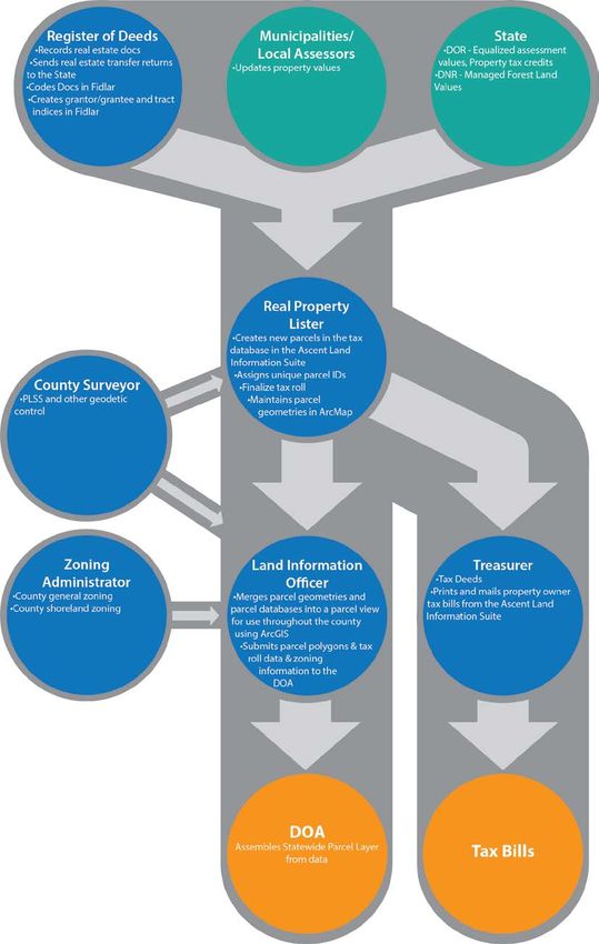
22Current Land Information System
County Parcel Data Workflow Diagram
23Technology Architecture and Database Design
Calumet County’s Land Information program is largely based in a Windows environment. Recently the tax
side of the land records program moved from an AS400 base to a SQL based system.
The Land Information Office currently operates with ESRI and Microsoft SQL software. In the late
1990’s Calumet County migrated the vast majority of its GIS data to ESRI’s ArcMap platform. By 2011 the
Land Information Office had migrated the GIS data to an enterprise database environment with ArcSDE,
ArcGIS Server, and Microsoft SQL.
The Treasurer and Real Property Lister use the Transcendent Technologies Ascent Land Records
Suite which is based in a web interface and a SQL backbone. The Real Property Lister uses ArcMap to do
the parcel mapping and maintains the tax and land tabular data in the Transcendent Technologies Ascent
Land Records Suite. Data from the Ascent Land Records suite is merged with the GIS polygons, which is
then used by the public and staff.
The Register of Deeds office uses Fidlar for their daily operations. Once social security number
redaction is complete ROD documents will be consumable online via Tapestry.
Hardware
• Lenovo ThinkStation
• ProLiant DL380 Gen9 Server
• Trimble R2
• iPad
• Windows Surface tablet
Software
• ESRI ArcGIS (5 basic, 2 advanced licenses), Collector
• Autodesk Map (1 license), Civil (3 licenses)
• GPS Pathfinder
• Ascent Land Records Suite
• Fidlar ROD software
• SQL 2012
Website Development/Hosting
• GIS website is hosted and developed by ADC - http://calumetcowi.wgxtreme.com/
• Land Information website is hosted and developed in house - https://calumetmaps.com/
• ArcGIS Online Applications
Metadata and Data Dictionary Practices
Metadata Creation
• Metadata creation and maintenance process: Calumet County has metadata on most
datasets. It is created on the most requested datasets and can be created if none exists.
Metadata Software
• Metadata software: ArcCatalog
The software does generate metadata consistent with the FGDC Content Standard for
Digital Geospatial Metadata, and ISO geographic metadata standard 19115.
• Metadata fields manually populated: Any that are not automatically populated by
ArcCatalog
Metadata Policy
• Metadata Policy: None
24Municipal Data Integration Process
• Calumet County consumes parcel data developed by the cities of Appleton and Menasha. The
county created a script that pulls the parcel data from the respective municipality ftp sites.
Then it adds and calculates some fields, and merges the parcel data with the county parcel
data.
• Calumet County helps municipalities with zoning mapping, but the zoning data is not
integrated with the county zoning data.
25Public Access and Website Information
Public Access and Website Information (URLs)
Public Access and Website Information
GIS Webmapping Application(s)
Link - URL GIS Download Link - URL Real Property Lister Link - URL Register of Deeds Link - URL
https://calumetmaps.com/ https://calumetmaps.com/data.html https://ascent.co.calumet.wi.us/Land http://www.co.calumet.wi.us/index.as
Records/PropertyListing/RealEstateTa px?nid=173
xParcel#/Search
Single Landing Page/Portal for All Land Records Data
URL
https://calumetmaps.com/
Municipal Website Information
Municipal Website Municipal Website URL
City of Appleton GIS website https://gis.appleton.org/
26Data Sharing
Data Availability to Public
Data Sharing Policy
• The Land Information Office has long held the belief that all GIS data should be freely available
to the public. The most frequently used and requested GIS data is available on
www.CalumetMaps.com in shapefile format while more unusual GIS data is available upon
request.
Open Records Compliance
• Calumet County strives to comply with all open records laws.
Data Sharing Restrictions and Government-to-Government Data Sharing
Data Sharing Restrictions
• While the data is easily accessible online there are some use and distribution restrictions. To
see the complete License Agreement For Calumet County Digital Geographic Data Sets
document please see the Land Information page at the official Calumet County website,
http://www.co.calumet.wi.us/index.aspx?NID=203.
Government-to-Government Data Sharing
• The Land Information Office has long held the belief that all GIS data should be freely available
to the all government entities. The most frequently used and requested GIS data is available
on www.CalumetMaps.com in shapefile format while more unusual GIS data is available upon
request.
Training and Education
• The Land Information Office takes training and education very seriously. Internal LIO training is
included in the budget every year as are funds to attend national conferences and statewide
land information and GIS conferences.
• As new systems or applications come online the LIO offers training to all potential users.
274 CURRENT & FUTURE PROJECTS
This chapter lists the current and future land information projects the county is currently undertaking or
intends to pursue over its planning horizon. A project is defined as a temporary effort that is carefully
planned to achieve a particular aim. Projects can be thought of as the means to achieving the county’s
mission for its land information system.
County Land
Information PLAN
Plan
PROJECTS!
2019
2019-2021 Land Info Plan 2020
due at end of 2018
2022-2024 Land Info Plan 2021
due at end of 2021
APPLY FOR WLIP Parcel/
FUNDING Grant Tax Roll
FOR PROJECTS Application Submittal
(FOR NEXT
CALENDAR YEAR)
to DOA
Due Due
December 31st March 31st
REPORT Retained
ON Fee/
PROJECTS Grant
(FROM PREVIOUS
CALENDAR YEAR)
Report
Due
June 30th
Figure 1. The WLIP Land Information Plan/Grant Project Cycle 28Project #1: Bridge and Culvert Survey
Project Description/Goal
• To map the bridges and culverts in the county for use by Land and Water Conservation staff to
better simulate land surfaces for watershed mapping
• Land Info Spending Category: LiDAR, Other: GIS Layers
Business Drivers
• County lacks complete culverts and bridge dataset
• Dataset required for surface water modeling
Objectives/Measure of Success
• The dataset is used to accurately model surface water flow
Project Timeframes
Timeline – Project #1 Bridge and Culvert Survey
Milestone Duration Date
Project start – May 1, 2019
Collect data using high accuracy 3 months May – August 2019
GPS
Congregate and build dataset 3 months June 1–Sept 30, 2019
Project complete – Sept 30, 2019
Responsible Parties
• Calumet County GIS Administrator and Land & Water Conservation Staff
Estimated Budget Information
• See table at the end of this chapter.
Project #2: PLSS Mapping, Monumentation, and Maintenance
Project Description/Goal
• The Calumet County Land Information Office will continue to contract with our County Surveyor to
maintain the County PLSS on a 20 year cycle.
• Land Info Spending Category: PLSS
Business Drivers
• Nearly all land based operations in the County are based off of high accuracy PLSS
• PLSS mapping, maintenance, monumentation is necessary to maintain a survey grade PLSS
Objectives/Measure of Success
• The PLSS continues the 20 year maintenance cycle
• Annual report submitted by the county surveyor
• Field monuments remain in place and undisturbed
Project Timeframes
Timeline – Project #2 PLSS Mapping
Milestone Duration Date
Project start – Ongoing
5% of PLSS Monuments All Year Ongoing
maintained
Project complete – Perpetual
29Responsible Parties
• Calumet County Surveyor, Planning, Zoning, and Land Information Department
Estimated Budget Information
• See table at the end of this chapter.
Project #3: Website Update
Project Description/Goal
• The goal of the project is to update and modernize the CalumetMaps website.
• Land Info Spending Category: Website Development/Hosting Services
Business Drivers
• Provide reliable and easy portal for access to GIS data and information
Objectives/Measure of Success
• Website is reliably available to the public
Project Timeframes
Timeline – Project #3 Website Update
Milestone Duration Date
Project start – August 2018
Website Converted to 7 months Aug 2018 – Feb 2019
WordPress and updated
Project complete – Feb 2019
Responsible Parties
• Calumet County GIS Administrator
Estimated Budget Information
• See table at the end of this chapter.
Project #4: Staff Development and Training
Project Description/Goal
• The Calumet County Land Information Office is always focused on continued staff development
and training in order to keep up with emerging and changing technologies.
• Land Info Spending Category: Training and Education
Business Drivers
• Improve public relations
• Improve interdepartmental coordination
• Keep up with changing technologies
Objectives/Measure of Success
• Easy public access to high quality land records data and services
Project Timeframes
Timeline – Project #3 Website Update
Milestone Duration Date
Project start Ongoing Perpetual
30Responsible Parties
• Calumet County Planning, Zoning, and Land Information Office
Estimated Budget Information
• See table at the end of this chapter.
Project #5: Election Reporting System
Project Description/Goal
• Calumet County will design and implement a GIS based system for election reporting that will
modernize the current AS400 based system used by the County Clerk.
• Land Info Spending Category: Website Development/Hosting Services, Other: Voting
Business Drivers
• Current system is outdated and the workflow needs to be streamlined.
Objectives/Measure of Success
• The new system is SQL/GIS based
• Improved workflow, functionality, speed, and accuracy
Project Timeframes
Timeline – Project #5 Election Reporting System
Milestone Duration Date
Project start – July 2019
Development 8 months July 2019 – Feb 2020
Test 1 month Feb – March 2020
Project complete - Deployment – March 2020
Responsible Parties
• Calumet County GIS Administrator
• Calumet County Information Technology Department
• Calumet County Clerk
Estimated Budget Information
• See table at the end of this chapter.
Project #6: GIS Hardware Update
Project Description/Goal
• Update GIS Servers and Workstation
• Land Info Spending Category: Hardware
Business Drivers
• Hardware ages and needs to be updated to keep up with changes in technology
Objectives/Measure of Success
• New server and workstation installed and performing as expected
Project Timeframes
• 2020+/- one year
Responsible Parties
• Calumet County GIS Administrator
• Calumet County Information Technology Department
31Estimated Budget Information
• See table at the end of this chapter.
Project #7: Re-Index and Publish Permit Records Online
Project Description/Goal
• The Planning, Zoning, and Land Information Office will make all permit records available for
consumption online.
• Land Info Spending Category: Other – public outreach and printing
Business Drivers
• Increase public access to records
• Create more efficient workflow for zoning staff allowing the users to view documents on their own
Objectives/Measure of Success
• Scanned Permit documents are available for users to consume through Ascent Land Records Portal
Project Timeframes
Timeline – Project #7 Permit Records Online
Milestone Duration Date
Project start – Spring 2019
Configure documents 3 months Spring – Summer 2019
Work with Transcendent 3 month Summer – Fall 2019
Technologies to get documents
online
Project complete - Deployment – Winter 2019
Responsible Parties
• Transcendent Technologies - Contractor
• Calumet County Planning, Zoning, and Land Information Office
Estimated Budget Information
• See table at the end of this chapter.
Project #8: Orthophotography
Project Description/Goal
• To acquire high resolution orthophotography via a statewide or regional consortium
• Land Info Spending Category: orthoimagery
Business Drivers
• Zoning violations
• Data visualization
• Improved community understanding of county projects and initiatives
• Land use planning
• Changing landscape
• Natural resource management and protection
• Emergency management and response
• Updated building footprints
Objectives/Measure of Success
• High resolution 4-band color orthophotography with ASPRS Class 1 accuracy or greater
Project Timeframes
• Flight in spring 2021
• Delivery in winter 2021
32Responsible Parties
• Calumet County GIS Administrator and an outside contractor
Estimated Budget Information
• See table at the end of this chapter.
Project #9: Publish ROD Documents Online
Project Description/Goal
• To get all of the documents prepared for publishing online for public consumption
• Land Info Spending Category: Software
Business Drivers
• Register of Deeds documents need to be made available online
• Improved public service
Objectives/Measure of Success
• ROD documents are available online
Project Timeframes
• Redaction complete by summer 2020
Responsible Parties
• Calumet County Register of Deeds
Estimated Budget Information
• See table at the end of this chapter.
Project #10: LiDAR Acquisition
Project Description/Goal
• To acquire high accuracy LiDAR data.
• Land Info Spending Category: LiDAR
Business Drivers
• Data visualization
• Improved community understanding of county projects and initiatives
• Land use planning
• Changing landscape
• Natural resource management and protection
Objectives/Measure of Success
• High accuracy LiDAR capable of producing one foot contours or better
Project Timeframes
• Flight spring of 2018
• Delivery in spring of 2019
Responsible Parties
• Calumet County GIS Administrator
• Contractor
Estimated Budget Information
• See table at the end of this chapter.
33You can also read