Weather and Climate Monitoring Protocol, Channel Islands National Park, California - Techniques and Methods 2-B1
←
→
Page content transcription
If your browser does not render page correctly, please read the page content below
Prepared in cooperation with the National Park Service

Weather and Climate Monitoring Protocol,
Channel Islands National Park, California

Techniques and Methods 2–B1

U.S. Department of the Interior
U.S. Geological Survey
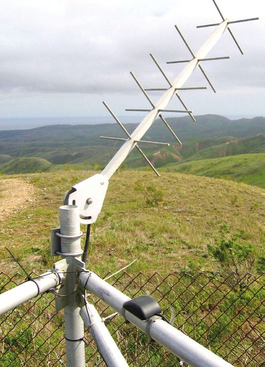
Cover photo caption:
Santa Rosa Island, Channel Islands National Park Remote Automated Weather Station
antenna, view to North. Photograph by Rockne Rudolph, National Park Service, 2006.
Weather and Climate Monitoring Protocol,
Channel Islands National Park, California
By Kathryn McEachern, Paula Power, Linda Dye, and Rocky Rudolph

Chapter 1 of

Section B, Climatological Science

Book 2, Collection of Environmental Data

Prepared in cooperation with the National Park Service

Techniques and Methods 2–B1

U.S. Department of the Interior
U.S. Geological Survey
U.S. Department of the Interior
DIRK KEMPTHORNE, Secretary

U.S. Geological Survey
Mark D. Myers, Director

U.S. Geological Survey, Reston, Virginia: 2008

For product and ordering information:
World Wide Web: http://www.usgs.gov/pubprod
Telephone: 1-888-ASK-USGS
For more information on the USGS--the Federal source for science about the Earth, its natural and living resources,
natural hazards, and the environment:
World Wide Web: http://www.usgs.gov
Telephone: 1-888-ASK-USGS

Any use of trade, product, or firm names is for descriptive purposes only and does not imply endorsement by the
U.S. Government.

Although this report is in the public domain, permission must be secured from the individual copyright owners to
reproduce any copyrighted materials contained within this report.

Suggested citation:
McEachern, Kathryn; Power, Paula; Dye, Linda; and Rudolph, Rocky, 2008, Weather and climate monitoring protocol,
Channel Islands National Park, California: U.S. Geological Survey Techniques and Methods 2–B1, 16 p. Available at
http://pubs.usgs.gov/tm/tm2b1/
iii

Contents
1.0 Introduction............................................................................................................................................1
    1.1 Background...................................................................................................................................1
    1.2 Objectives of Weather and Climate Monitoring......................................................................3
2.0 Island Weather Stations .....................................................................................................................3
    2.1 Anacapa Island Overview...........................................................................................................4
         National Park Service Remote Automated Weather Station ...............................................4
         Ranger Weather Station..............................................................................................................5
    2.2 Santa Cruz Island Overview.......................................................................................................5
         National Park Service Remote Automated Weather Station – Main Ranch......................6
         Weather Stations Operated by Others......................................................................................6
              California State University, Northridge............................................................................6
              Santa Barbara Amateur Radio Club – Diablo Peak........................................................6
              University of California, Santa Barbara...........................................................................7
         Ranger Weather Stations............................................................................................................7
              Scorpion................................................................................................................................7
              Navy Site...............................................................................................................................7
         Main Ranch Precipitation Data..................................................................................................7
    2.3 Santa Rosa Island Overview......................................................................................................8
         National Park Service Remote Automated Weather Station—Black Mountain...............8
         Ranger Weather Station..............................................................................................................8
    2.4 Santa Barbara Island Overview.................................................................................................9
         National Park Service Remote Automated Weather Station................................................9
         Ranger Weather Station..............................................................................................................9
    2.5 San Miguel Island Overview......................................................................................................9
         National Park Service Remote Automated Weather Station................................................9
         Remote Automated Weather Station Operated by the Navy...............................................10
         Ranger Weather Station............................................................................................................10
3.0 Weather Station Maintenance and Diagnostics...........................................................................11
    3.1 Remote Automated Weather Station (RAWS) Maintenance..............................................11
    3.2 Ranger Weather Station Instrument Maintenance..............................................................11
4.0 Weather and Climate Monitoring Program Tasks and Roles.......................................................11
5.0 Reporting..............................................................................................................................................12
6.0 Training Requirements........................................................................................................................13
7.0 Channel Islands National Park Weather Data Websites..............................................................13
8.0 Acknowledgments..............................................................................................................................13
9.0 References...........................................................................................................................................13
Appendix A. Channel Islands National Park Remote Automated Weather Stations ....................14
Appendix B. Attributes of Ranger Weather Station.............................................................................15
iv

Figures
Figure 1.   Map showing the California Channel Islands, California… …………………………              2
Figure 2.   Map showing location of the Remote Automated Weather Stations (RAWS)
            and Ranger Weather Station on Anacapa Island, Channel Island National Park,
            California… …………………………………………………………………………                                        4
Figure 3.   Map showing location of seven Remote Automated Weather Stations (RAWS)
            and two Ranger Weather Stations on Santa Cruz Island, Channel Island National
            Park, California… ……………………………………………………………………                                    5
Figure 4.   Map showing location of one Remote Automated Weather Station (RAWS)
            and current and historic Ranger Weather Stations on Santa Rosa Island,
            Channel Island National Park, California… …………………………………………                      8
Figure 5.   Map showing location of one Remote Automated Weather Station (RAWS)
            and a Ranger Weather Station on Santa Barbara Island, Channel Islands
            National Park, California… …………………………………………………………                               9
Figure 6.   Map showing location of a Remote Automated Weather Station (RAWS)
            and a Ranger Weather Station on San Miguel Island, Channel Islands National
            Park, California… ……………………………………………………………………                                    10

Tables
Table 1. Automated Remote Weather Stations operated by other agencies or
          organizations on Santa Cruz Island and San Miguel Islands, Channel Islands
          National Park, California… …………………………………………………………                                  6
Table 2. Websites with data from Remote Automated Weather Stations located in
          Channel Islands National Park, California … ………………………………………                       12
Appendix A. Channel Islands National Park Remote Automated Weather Stations … ………           14
Appendix B. Attributes of Ranger Stations Weather Stations on the Channel Islands,
          California… …………………………………………………………………………                                          15
Weather and Climate Monitoring Protocol, Channel
Islands National Park, California
By Kathryn McEachern1, Paula Power2, Linda Dye2, and Rocky Rudolph2
1.0 Introduction with Mexico (fig. 1). The Park islands lie 20 to 61 kilometers
(12 to 38 miles) offshore in the Pacific Ocean. They span
Weather and climate are strong drivers of population a major transition in climate that begins at the California
dynamics, plant and animal spatial distributions, community coastline where the cool waters of the northern Humboldt
interactions, and ecosystem states. Information on local Current mix with the warmer waters of the California Current
weather and climate is crucial in interpreting trends and from the south (Redmond and McCurdy, 2005). The Santa
patterns in the natural environment for resource management, Barbara Channel separates the northern four islands from the
research, and visitor enjoyment. This document describes mainland and the San Pedro Channel separates the southern
the weather and climate monitoring program at the Channel islands from mainland California. Both channels are major
Islands National Park (fig. 1), initiated in the 1990s. Manual shipping lanes for commercial and recreational traffic traveling
and automated stations, which continue to evolve as north and south along the California coastline.
technology changes, are being used for this program. The The five Park islands include Anacapa Island (AI), Santa
document reviews the history of weather data collection Cruz Island (SCI), Santa Rosa Island (SRI), and San Miguel
on each of the five Channel Islands National Park islands, Island (SMI) in the northern island group and Santa Barbara
presents program administrative structure, and provides an Island (SBI) in the southern group. Ownership of the islands
overview of procedures for data collection, archival, retrieval, varied in the past, ranging from private ranchers to government
and reporting. This program overview is accompanied by the agencies. Anacapa, San Miguel, and Santa Barbara Islands,
“Channel Islands National Park Remote Automated Weather administered by the Department of Defense, were transferred
Station Field Handbook” and the “Channel Islands National to the National Park Service and designated as the Channel
Park Ranger Weather Station Field Handbook.” These Islands National Monument in 1938 and re-dedicated as
Handbooks are maintained separately at the Channel Island Channel Islands National Park in 1980. Santa Rosa Island was
National Park as “live documents” that are updated as needed purchased from private owners in 1986. The eastern 10 percent
to provide a current working manual of weather and climate of Santa Cruz Island was transferred to the Channel Islands
monitoring procedures. They are available on request from National Park in 1997, and another 14 percent was deeded to
the Weather Program Manager (Channel Islands National the NPS by The Nature Conservancy in 2000. All five islands
Park, 1901 Spinnaker Dr., Ventura, CA 93001; 805.658.5700). are currently administered by the National Park Service,
The two Field Handbooks describe in detail protocols for although ownership is still shared with others in several
managing the four remote automated weather stations (RAWS) instances. For example, the U.S. Coast Guard owns the East
and the seven manual Ranger Weather Stations on the islands, Anacapa lighthouse and surrounding 65 hectares (161 acres),
including standard operating procedures for equipment the U.S. Navy owns San Miguel Island, and The Nature
maintenance and calibration; manufacturer operating manuals; Conservancy owns the western 76 percent of Santa Cruz
data retrieval and archiving; metada collection and archival; Island. The history of weather data collection for the islands
and local, agency, and vendor contracts. varies with the ownership history. Weather records, primarily
precipitation, were kept by some ranchers and government
agencies; thus records extend back to the early 1900s for some
1.1 Background of the islands. Until development of the long-term weather
monitoring program by the NPS in the mid-1980s, there
Channel Islands National Park includes the northernmost was little consistency among the islands in how weather was
five of the eight offshore California Channel Islands, scattered measured and recorded (Richards, 1997).
from near Point Conception, California, USA, to the border
1
U.S. Geological Survey, Western Ecological Research Center, Channel
Islands Field Station.
2
National Park Service, Channel Islands National Park.2 Channel Islands National Park Weather and Climate Monitoring Protocol
Channel Islands National Park Service
California U.S. Department of the Interior
The California Channel Islands 0 10 20 40 Km
Po int C o nc e pt i o n
Santa Bar bara !
P
Santa Ba
rba Ventura
ra C P!
h an
ne Oxnard
San Miguel Santa Cruz l
P!
34°0'0"N
!
Los A ngeles
P
Anacapa
Santa Rosa
San
Pe
dr
o
Ch
an
n
e
l
Santa Barbara
Santa Catalina
San Nicolas
33°0'0"N
P a c i f i c
O c e a n
San Clemente
Legend U. S. A .
M ex ic o
National Park Boundary
Produced by Channel Islands GIS, 2008 | Data courtesy of USGS and NPS
120°0'0"W 119°0'0"W 118°0'0"W 117°0'0"W
Figure 1. The California Channel Islands, California.
For the weather monitoring program, Remote Automated and climate monitoring program, including the choices of
Weather Stations (RAWS) were established on four of the parameters to measure, RAWS and Ranger Weather Station
islands; no RAWS was established on San Miguel Island. site selection, considerations for data handling and display,
Daily measurements are made at six additional sites by Park and operating procedures for site maintenance. The Channel
staff when they are on the islands (Ranger Weather Station Islands National Park Weather and Climate Monitoring
data). These measurements supplement the RAWS data. The Program builds upon their recommendations. This program
RAWS data are downloaded via satellite and archived by protocol document presents an overview of weather data
the Western Regional Climate Center (WRCC) at the Desert collected on each island, including historic and current
Research Institute in Reno, Nevada. The WRCC also archives station locations, historic data available, equipment used and
the Ranger Weather Station data for the Park. The weather maintenance schedules, procedures for data handling and
data are available through the WRCC website at http://www. display, general staffing and training requirements, annual
wrcc.dri.edu/channel_isl. The RAWS parameters measured reporting, and program administration. Two additional stand-
include precipitation, air temperature, relative humidity, alone Field Handbooks presenting operational details on
wind speed and direction, solar radiation, fuel moisture, fuel station equipment, manufacturer manuals, equipment technical
temperature, and barometric pressure. support, and station maintenance for the RAWS and Ranger
Redmond and McCurdy (2005) discuss an approach Weather Stations are available from the Weather Program
to weather and climate monitoring among the Channel Manager at Channel Islands National Park. It is anticipated
Islands in the context of nationwide climate monitoring and that this protocol document and the two Field Handbooks will
modeling. Their rationale and specific design considerations require updating as technology changes; the updates will be
form the basis for the Channel Islands National Park weather logged and tracked independently for this protocol document2.0 Island Weather Stations 3
and each Handbook. Operational changes will be incorporated fire planning and management, for visitor inquiries,
into the Weather and Climate Monitoring Program documents and for climatic, physical and ecological research
as they are made, rather than being compiled annually into a needs.
single Program report. In this way, operations staff will always
have current guidelines and contacts for procedures and • Provide data for evaluation of climate patterns and
protocols essential for efficient and continuous data collection long-term trends. Identify trends and patterns over
and archival. periods of 5 to 100 years in surface temperatures,
wind speed and direction, precipitation, and climate
extremes on the five islands of the Channel Islands
1.2 Objectives of Weather and Climate National Park.
Monitoring
The Channel Islands National Park maintains long-term
monitoring of terrestrial and marine flora and fauna, along 2.0 Island Weather Stations
with visitor-use statistics and interpretive education programs.
The relative year-to-year variation in winter precipitation Of the five islands making up the Channel Island
is greater along the California coast between Los Angeles National Park, all but San Miguel have one or more Remote
and San Diego than anywhere else in the United States Automated Weather Stations (RAWS). Data from the RAWS
(Yoho and others, 1999; Redmond and McCurdy, 2005). In are supplemented by data collected using weather instruments
the Mediterranean climate of this region, weather patterns manually operated by island staff (Ranger Weather Station
influence plant and animal abundance, and climate often data). Collectively, the stations provide data on weather from
explains the annual patterns and long-term trends seen in the both the marine layer and the terrestrial climate regimes of the
monitoring data. Climate also influences the distributions of islands. Redmond and McCurdy (2005) provide an analysis
plants and animals across the islands, and it forms the context of considerations for siting weather stations in the context of
for the development of the unique island ecosystems protected local and regional climate analysis. In addition to the Park, a
by the Park. Evidence is accumulating that California’s number of agencies and organizations have also invested in
climate is changing. A major unresolved regional question island weather stations, including the National Interagency
is whether variations in California’s rich marine upwelling Fire Center (NIFC); the U.S. Navy; the county of Santa
systems track variations in the mainland’s climate. Owing to Barbara; the California State University, Northridge (CSUN);
its extensive monitoring program and offshore location, the the University of California, Santa Barbara; and the Santa
Channel Islands National Park is well suited to address such Barbara Amateur Radio Club. Collectively, these stations
local, regional, and globally important questions with weather address the needs of Channel Islands National Park operations
and other monitoring data. and resource management, fire planning and management,
It is crucial that the weather monitoring program be Navy operations, mariner safety, and specific research needs.
conducted in a consistent manner through time to provide a Although each station contributes to a holistic view of weather
continuous and reliable record of weather and climate across and climate across the islands, the Channel Islands National
all of the islands. Weather monitoring includes data acquisition Park confines its monitoring program to those RAWS and
and storage, reporting, and careful documentation of station Ranger Weather Stations owned and operated by the Park. The
locations, maintenance, and performance through time. This stations are discussed in this report, and the data are accessible
protocol provides guidelines for consistent, long-term weather through the WRCC website.
monitoring for use by the National Park Service (NPS) and The following sections describe the history of the
others. Park-managed RAWS and Ranger Weather Stations on each
The objectives of the Weather and Climate Monitoring island, including placement of the stations, parts upgrades,
Program at the Channel Islands National Park and protocol maintenance schedules, and funding and maintenance
follow: responsibilities. Appendixes A and B list station locations,
data collected, and types of sensors used for the RAWS and
• Provide the Channel Islands National Park with hourly
Ranger Weather Stations. In general, automated weather
and daily data on precipitation, air temperature, wind
data collection began on the islands in the 1990s. NPS
direction and speed, solar radiation, fuel moisture and
staff has recorded weather observations using various
fuel temperature, barometric pressure, and dew point.
types of equipment since the early 1990s. Historic weather
Data are digitally accessible via the Internet in near-
observations were made on most of the islands during the
real time for a variety of users, including Park staff,
last century, however, those records vary in quality and
cooperators, visitors, and the public.
consistency. The Park archives these records within the
• Provide weather and climate data for a variety of uses, Weather and Climate Monitoring Program, but they are not
such as early warnings of potential hazards to both included as part of the contemporary island weather record
marine and terrestrial systems, for mariner safety, for available on-line.4 Channel Islands National Park Weather and Climate Monitoring Protocol
2.1 Anacapa Island Overview instrumentation on a platform attached to the building would
have no adverse effect on the historic building.
The Park operates one RAWS and one Ranger Weather The Anacapa Island RAWS provides near real-time
Station on East Anacapa Island (fig. 2). The U.S. Coast Guard weather data for the east end of the Santa Barbara Channel, the
collected weather observations prior to National Park Service most heavily traveled section of the channel. These data aid
management of the island. However, those records are lost, mariners by notifying them of potentially dangerous changes
and the earliest weather records date from the 1990s. in wind conditions. The station also provides long-term
climate data for resource management and fire planning.
The RAWS is mounted on the historic fog horn building
National Park Service Remote Automated at an elevation of 84 meters (m) (277 feet [ft]) above mean
Weather Station sea level, latitude 34°00'57", longitude 119°21'35". Because
the weather station is mounted on the fog horn building,
The Anacapa Island weather program was developed sensor cables are custom-made to specific lengths listed in the
in partnership with Santa Barbara County’s Fisheries Channel Islands National Park Remote Automated Weather
Enhancement Fund, which helps mitigate the adverse Station Field Handbook. Power is supplied with a 20-watt
impacts of offshore oil development on local commercial solar panel and auxiliary battery. The system is a Handar 555.
fishing. The California Office of Historic Preservation, the Sensors include wind speed/wind direction, precipitation,
Coast Guard, the National Weather Service, and commercial solar radiation, relative humidity/air temperature, and fuel
fishers supported the installation of a weather stations on moisture/fuel temperature. For a complete description of
East Anacapa Island. The weather station was funded by software and sensors on the Anacapa station see Appendix A.
the county of Santa Barbara through a Memorandum of Data are transmitted through a Geostationary Operational
Agreement between the County and the Park (Agreement Environmental Satellite (GOES) antenna to a satellite, where
No. G8120020002). California State University, Northridge they are downloaded and posted on the WRCC website, in
(CSUN), personnel installed the station in May 2004 cooperation with NIFC. The data are recorded at 10-minute
(Appendix A). intervals and summarized by hour on the website. Scheduled
The weather station was placed on the historic fog horn maintenance of the RAWS consists of an annual sensor and an
building to record unobstructed wind conditions, including as-needed cable swap required because the harsh environment
Santa Ana winds. California’s Office of Historic Preservation quickly corrodes weather station parts.
concurred with the Park’s finding that placing weather
119°26'0"W 119°25'0"W 119°24'0"W 119°23'0"W 119°22'0"W
Channel Islands National Park, California
Anacapa Island Weather Stations Anacapa RAWS
Ranger station
34°1'0"N
Legend
34°0'0"N
Elevation Location
800 m Oxnard
400 m
0m
TYPE
RANGER STATION
RAWS 0 0.5 1 2 Km
Produced by Channel Islands GIS, 2008 | Data courtesy of USGS and NPS
Figure 2. Location of the Remote Automated Weather Stations (RAWS) and Ranger Weather Station on Anacapa Island, Channel
Island National Park, California.2.0 Island Weather Stations 5
Ranger Weather Station obstruction of wind flow between the shelter and the rain
gauge. The shelter houses a max/min thermometer and
Between 1992 and 2000, a standard white wooden an electronic temperature and relative humidity logger.
Forest Service type weather station was used for collection of The logger data is downloaded periodically and archived
weather observations by island staff. It had open-air slatted at the WRCC (Channel Islands National Park Ranger
sides approximately 1.5 m (5 ft) off the ground and was Weather Station Field Handbook). Maximum and minimum
located a few feet from the northeast corner of the Ranger’s temperatures, current air temperature, relative humidity,
residence. In 1997, the residence basement floor cracked, precipitation, wind speed, wind direction, and horizontal
requiring construction of a new foundation. As a result, the visibility are reported each morning to Park Dispatch by island
instrument housing was moved several feet northeast, to a staff (Appendix B). These data are archived at Channel Islands
location half-way between the Ranger’s and the Maintenance National Park headquarters.
Manager’s residences (T. Gottshall, Channel Islands National
Park, oral commun., 2005). A simple mercury maximum-
minimum (max/min) thermometer with a magnet reset 2.2 Santa Cruz Island Overview
was used in the shelter, and there was no relative humidity
instrument. Ocean water temperature was taken at the landing Channel Islands National Park installed a RAWS on
cove dock each morning using a thermometer that was hung Santa Cruz Island in 1990 (fig. 3). It is located on the slope
from a string at a depth of about 1.5 m (5 ft) below the water above the Main Ranch house in the Central Valley on The
surface (T. Gottshall, Channel Islands National Park, oral Nature Conservancy property. Additionally, there are five
commun., 2005). RAWS owned and maintained by CSUN (Boyle and Laughrin,
Before 1997, the anemometer was on top of the 1999) and one RAWS owned and operated by the Santa
communications tower on the northeast corner of the Ranger’s Barbara Amateur Radio Club on Diablo Peak. The University
residence. Because construction of the residence foundation of California, Santa Barbara, operates remote weather stations
destabilized the tower, the anemometer was moved to the at several locations on the island for research purposes (C.
chimney of the residence where it could be easily reached. Still, University of California Santa Barbara Department of
Data cables were fed into the house so that wind speed could Geography, written commun., 2007). These stations are not
be read indoors. A standard 8-inch copper rain gauge has been part of the NPS network, although they may provide important
in place since 1997; it is located where the residence walkway data over the short-term of record.
meets the road (T. Gottshall, Channel Islands National Park, The Park maintains two Ranger Stations for weather
oral commun., 2005). data collection on Santa Cruz Island, one at the Scorpion
In 2007, a new shelter was installed about 1.5 m (5 ft) Anchorage employee housing and the second at the U.S. Navy
north of the rain gauge, near the junction of the Ranger site on the isthmus. Additionally, precipitation data have been
residence walkway and the road. This distance prevents recorded at the Main Ranch from 1904 to the present; the data
119°55'0"W 119°50'0"W 119°45'0"W 119°40'0"W 119°35'0"W
Channel Islands National Park, California
Santa Cruz Island Weather Stations 0 1 2 4 6 Km
34°5'0"N
Scorpion
Diablo Peak
Legend Christy
Prisoners Smugglers
Elevation Airport Pine Forest
800 m
400 m Del Norte
0m
Embudo Main Ranch
34°0'0"N
Weather Sites Sauces Navy Site
TYPE Main Ranch RAWS Location
Oxnard
CSUN Willows
UCSB
HISTORIC
RANGER STATION
RAWS NPS
RAWS SBARC
Produced by Channel Islands GIS, 2008 | Data courtesy of USGS and NPS
Figure 3. Location of seven Remote Automated Weather Stations (RAWS) and two Ranger Weather Stations on Santa Cruz Island,
Channel Island National Park, California.6 Channel Islands National Park Weather and Climate Monitoring Protocol
are maintained by the University of California, Santa Cruz California State University, Northridge
Island Reserve (L. Laughrin, Director, University of California
CSUN owns and maintains five weather stations on Santa
Santa Cruz Island Reserve, oral commun., 2006).
Cruz Island. The stations were installed between 1995 and
1999 (fig. 3, table 1). They all are equipped with Campbell
National Park Service Remote Automated Scientific data loggers with the exception of Del Norte, which
is equipped with a Handar 555. The Del Norte station is of
Weather Station – Main Ranch
particular interest because the data are archived and reported
The RAWS at the Main Ranch is maintained by National by the WRCC, along with the Channel Islands National Park
Park Service personnel. The station was originally installed in data for Santa Cruz Island. The equipment is identical to the
April 1990 at La Centinella (approximately 366 m (1,200 ft) Main Ranch RAWS, except that solar radiation is not recorded
elevation), but was moved out of that uncommonly cold valley (Appendix A). This station is located at latitude 34º00'33",
in October 1994 to a more representative locale on a hill longitude 119º39'15", at an elevation of 244 m (800 ft) above
above the Main Ranch (122 m (400 ft) elevation) at latitude mean sea level on a nearshore marine terrace approximately
33º59'45", longitude 119°43'20". This station is equipped with 2 kilometers (1.5 miles) east of the pier at Prisoners Harbor.
a Handar 555. Sensors include temperature, relative humidity,
wind speed, wind direction, precipitation, and solar radiation. Santa Barbara Amateur Radio Club – Diablo Peak
The weather station is solar powered but has an auxiliary
The Santa Barbara Amateur Radio Club, Inc. (SBARC)
battery. Data are transmitted through a GOES antenna to a
funded and installed a RAWS on Diablo Peak at an elevation
satellite, where they are downloaded and posted on the WRCC
of 742 m ( 2,434 ft) above mean sea level on 15 January
website, in cooperation with NIFC. The data are recorded at
2004 as a public service. The Santa Barbara Amateur Radio
10-minute intervals and summarized by hour on the website.
Club is a non-profit 501(c)3 charitable and educational
Weather station sensors are replaced two times per year and
corporation founded in 1920 (B. Talanian, Santa Barbara
cables annually. For a complete description of software and
Amateur Radio Club, written commun., 2005). The weather
sensors on the Santa Cruz Island–Main Ranch Station see
station monitors and reports data to the mainland every 5
Appendix A.
minutes via VHF radio. The data are collected by the Civilian
Weather Observer Program (CWOP). The station reports
Weather Stations Operated by Others wind speed, wind direction, temperature, barometric pressure,
humidity, dew point, and precipitation. A full description of
Several organizations operate additional weather stations this weather system data is explained on links at the following
on Santa Cruz Island to fill research and recreational needs. webpage: http://www.met.utah.edu/cgi-bin/roman/meso_base.
Although not maintained by Channel Islands National Park, cgi?stn=AR320.
these data are available on request from these organizations,
and they extend the Park’s program with valuable weather
observations from other locations on Santa Cruz Island.
Table 1. Automated Remote Weather Stations operated by other agencies or organizations on Santa Cruz Island and San Miguel
Islands, Channel Islands National Park, California.
[SBARC, Santa Barbara Amateur Radio Club; CSUN, California State University, Northridge; UCSB, University of California, Santa Barbara]
Elevation,
Location in meters (feet)
Site Data logger Period of record Operator
(latitude/longitude) above mean
sea level
Santa Cruz Diablo Peak 34°01′45″ N/119°47′09″ W Peet Bros. 742 (2,434) Jan. 2004–present SBARC
Santa Cruz Prisoners 34°00′59″ N/119°40′37″ W Campbell Scientific CR10X 126 (414) June 1995–present CSUN
Santa Cruz Christy Airport 34°01′04″ N/119°51′21″ W Campbell Scientific CR10X 63 (208) Dec. 1996–present CSUN
Santa Cruz Willows 33°58′47″ N/119°45′46″ W Campbell Scientific CR10X 308 (1,012) Nov. 1999–present CSUN
Santa Cruz Pine Forest 34°00′46″ N/119°48′07″ W Campbell Scientific CR10X 442 (1,450) Dec. 1996–present CSUN
Santa Cruz Del Norte1 34°00′33″ N/119°39′15″ W Handar 555 244 (800) Dec. 1999–present CSUN
San Miguel Navy 34°01′58″ N/120°21′51″ W Handar 555 255 (835) intermittent U.S. Navy
Santa Cruz Sauces 34°0′3.88″ N/119°49′4.48″ W Campbell Scientific 290 (951) Dec. 2003–present UCSB
Santa Cruz Embudo 34°0′47.20″ N/119°48′11.12″ W Campbell Scientific 420 (1,378) Sept. 2005–present UCSB
1
Santa Cruz Island Del Norte station is owned and maintained by CSUN, but the data are collected and archived by Western Regional Climate Center. This
station is part of the Remote Automated Weather Station (RAWS) program.2.0 Island Weather Stations 7
The SBARC weather system equipment is manufactured Club, with on-line data access to the datalogger via the Club’s
by Peet Bros and is a low-end system costing less than $1,000. wireless connections to the mainland. This station is located
Systems of this type are not tested annually for precision or at latitude 34°0'47.20"N and longitude 119°48'11.12"W at an
accuracy. There is no periodic method or instruction by the elevation of 420 m (1,378 ft) above mean sea level.
manufacturer to perform calibration of any sensors as there is
with the high-end systems operated by the National Weather
Service (NWS). However, this type of system has improved Ranger Weather Stations
immensely in the past several years because of refinements in Weather data are collected and reported daily to Park
miniature sensor accuracy and micro-processors. The readings Dispatch by Channel Islands National Park staff at two
from thousands of similar stations provide specific readings in locations on Santa Cruz Island: at the Scorpion housing
micro climates not otherwise covered by the National Weather complex on the east end of the island and at the U.S. Navy site
Service (B. Talanian, Santa Barbara Amateur Radio Club, on the isthmus (Appendix B).
written commun., 2005).
Scorpion
University of California, Santa Barbara
A standard Forest Service type instrument shelter with
The University of California, Santa Barbara, operates non-standard temperature and humidity equipment was used
two Campbell Scientific weather stations on Santa Cruz to collect weather observations at the NPS Scorpion housing
Island associated with fog and climate research conducted complex beginning in 2002. Upgraded weather equipment
by Dr. Christopher Still in the Department of Geography (C. including a max/min thermometer, a relative humidity and
Still, University of California, Santa Barbara Department temperature logger, and a precipitation gauge were installed
of Geography, written commun., 2007). The Sauces station there in February 2006 (Appendix B).
was installed in December 2003. It logs the following
measurements at 15-minute intervals: air temperature and
Navy Site
relative humidity inside and outside the adjacent Bishop pine
canopy, dewpoint temperature, photosynthetically active From 2002 until 2007, a Davis Vantage PRO all-in-one
radiation (PAR, 400–700 nanometer (nm) wavelengths), solar wireless digital readout display was the primary source for
radiation (400–111 nm), wind speed and direction, and vertical Ranger Weather Station information at the U.S. Navy site. The
precipitation (rain) and horizontal precipitation (fog). These sensors were mounted on the roof of an outbuilding upslope
measurements are supplemented with numerous measurements from employee housing. The unit displayed temperature
of soil moisture and temperature at multiple depths beneath (inside, outside), humidity (inside, outside), wind chill,
the pine canopy and beneath an adjacent grassy area. Both barometric pressure, and precipitation. In 2007, the Davis
relative humidity and temperature sensors (Vaisala HMP- Vantage PRO was replaced with a standard Forest Service
45C) are calibrated annually by Campbell Scientific. The type shelter located near the north parking lot of the Navy
weather station is solar powered and has an auxiliary battery. site housing. The shelter houses a max/min thermometer, an
The data are archived on a Campbell CR10x datalogger electronic temperature and humidity logger, and instruments
and downloaded several times a year by members of the similar to those on Anacapa Island. The logger data are
Still Laboratory (table 1). This station is located at latitude periodically downloaded and archived at the WRCC.
34°0'3.88"N and longitude 119°49'4.48"W at an elevation of
290 m (951 ft) above mean sea level.
The upper Embudo Canyon station was installed in Main Ranch Precipitation Data
September 2005. The following measurements are logged at Currently, the Director of the Santa Cruz Island Reserve,
15-minute intervals: air temperature and relative humidity, part of the University of California Natural Reserve System,
dewpoint temperature, photosynthetically active radiation collects precipitation and max/min temperature data in the
(PAR), solar radiation (400–111 nm), net radiation (net Central Valley. These data have been collected at the Reserve
of downwelling and upwelling radiation from 0–100 um Director’s house approximately 1.0 kilometers (0.62 miles)
wavelengths), wind speed and direction, vertical precipitation west of the Main Ranch from 1976 to the present. This extends
(rain), and horizontal precipitation (fog). The relative humidity the historic record for the Central Valley from 1903 to the
and temperature sensor (Vaisala HMP-45C) is calibrated present. Precipitation data collected in the Central Valley are
annually by Campbell Scientific. The weather station is solar archived with the Weather and Climate Monitoring Program
powered and has an auxiliary battery. The data are archived on data files on the Channel Islands National Park computer
a Campbell CR1000 datalogger and downloaded several times network.
a year by members of the Still Laboratory. This site also has a
webcam accessible through the Santa Barbara Amateur Radio8 Channel Islands National Park Weather and Climate Monitoring Protocol
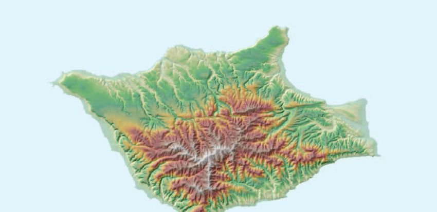
2.3 Santa Rosa Island Overview Ranger Weather Station
The Channel Islands National Park maintains one RAWS Ranger Weather Station observations were collected from
and one Ranger Weather Station on Santa Rosa Island (fig. 4). April 1987 through January 1992 at the historic NPS housing
The Ranger Weather Station has been moved several times at Johnson’s Lee located on the south side of the island (fig. 4).
since NPS acquired the island in 1987. Data are no longer This station was equipped with a max/min thermometer; a
collected at past Ranger Weather Station locations. battery powered digital wind speed instrument, a relative
humidity sling psychrometer, and a standard rain gauge. In
January 1992, the Park employee housing was moved to
National Park Service Remote Automated Bechers Bay where an instrument shelter and rain gauge were
Weather Station—Black Mountain installed. In fall of 1998, the instruments were moved to the
new Park employee housing on the bluff between Windmill
The Santa Rosa Island RAWS was installed on Black and Cherry Canyons (M. Senning, Channel Islands National
Mountain in April 1990 at 396 m (1,298 ft) elevation, latitude Park, written commun., 2000). The shelter and instruments,
33º58'40", longitude 120º04'40. The weather station is solar but not the rain gauge, were destroyed by high winds in 2002.
powered and has an auxiliary battery. The system is a Handar From 2002 until 2007, island staff used a hand-held device
555. Sensors include air temperature, relative humidity, wind that measured temperature, relative humidity, barometric
speed, wind direction, precipitation, solar radiation, and fuel pressure, and wind speed (M. Senning, Channel Islands
moisture/fuel temperature. The sensors and cables are replaced National Park, oral commun. 2006). A small weather station
annually. Data are transmitted through a GOES antenna to a housing a max/min thermometer and an electronic temperature
satellite, where they are downloaded and posted on the WRCC and relative humidity logger was installed in 2007. The logger
website, in cooperation with NIFC. The data are recorded at data are downloaded periodically and archived at the WRCC
10-minute intervals and summarized by hour on the website. (Channel Islands National Park Ranger Weather Station Field
For a complete description of system and sensors, see Handbook). Maximum and minimum temperatures, current air
Appendix A. temperature, relative humidity, precipitation, wind speed, wind
direction, and horizontal visibility are reported each morning
to Park Dispatch by island staff (Appendix B). These data are
archived at Channel Islands National Park headquarters and
reported on the WRCC web site.
120°15'0"W 120°10'0"W 120°5'0"W 120°0'0"W 119°55'0"W
Channel Islands National Park, California
Santa Rosa Island Weather Stations 0 1 2 4 6 Km
Bechers Bay
NPS Housing
34°0'0"N
Black Mountain
Legend
Elevation
Location
800 m
Oxnard
400 m
0m
33°55'0"N
TYPE
HISTORIC Johnson's Lee
RANGER STATION
RAWS
Produced by Channel Islands GIS, 2008 | Data courtesy of USGS and NPS
Figure 4. Location of one Remote Automated Weather Station (RAWS) and current and historic Ranger Weather Stations on Santa
Rosa Island, Channel Island National Park, California.2.0 Island Weather Stations 9
2.4 Santa Barbara Island Overview sensor, a maximum-minimum thermometer, and relative
humidity data logger housed near the residence in a small
Channel Islands National Park operates one RAWS and U.S. Forest Service type instrument shelter identical to other
one Ranger Weather Station on Santa Barbara Island (fig. 5). island Ranger Weather Stations. The older rain gauge was
Data were not collected on the island historically. replaced in its original location with a new, standard rain
gauge. Maximum and minimum temperatures, current air
temperature, relative humidity, precipitation, wind speed,
National Park Service Remote Automated wind direction, and horizontal visibility are reported to Park
Weather Station Dispatch when Park personnel are present on the island.
These data are archived at Channel Islands National Park
The Santa Barbara Island RAWS was installed in April headquarters and reported on the WRCC web site.
1995 at Arch Point, elevation 54 m (176 ft) above mean sea
level, latitude 33º29'00", longitude 119º02'00". The station is
equipped with a Handar 555. Sensors include air temperature, 2.5 San Miguel Island Overview
relative humidity, precipitation gauge, wind speed, wind
direction, and solar radiation. The system is solar powered The most reliable weather data for San Miguel comes
and has an auxiliary battery; sensors must be swapped two from Ranger Weather Station observations. There have been
times per year. Data are transmitted via satellite to the WRCC several remote stations on the island since the early 1990s
and posted on the Internet. In June 1998, the station was (fig. 6), but they have not been maintained, and the automated
transported to the mainland for servicing and returned to Santa record has been inconsistent through time.
Barbara Island. See Appendix A for details on the system and
sensors.
National Park Service Remote Automated
Weather Station
Ranger Weather Station
In 1997, the NPS installed a Met One weather data logger
A rain gauge and a thermometer were installed on and instruments. The station was placed near wind generators
Santa Barbara Island in 1992 when a shop and house were south of the current Ranger Station. The station functioned
constructed near Landing Cove. They were installed on a properly for a brief period, but individual component failures
post between the shop and employee housing. The weather resulted in inconsistent data. Funds were not available to
equipment was upgraded in 2007 with an air temperature maintain the station and it was eventually removed.
119°4'0"W 119°3'30"W 119°3'0"W 119°2'30"W 119°2'0"W 119°1'30"W 119°1'0"W 119°0'30"W 119°0'0"W
Channel Islands National Park, California
±
33°29'30"N
Santa Barbara Island Weather Stations SBI RAWS 0 0.5 1 Km
G
33°29'0"N
Landing Cove
!
33°28'30"N
Location
Oxnard
Legend
33°28'0"N
TYPE
! RANGER STATION
G RAWS
Produced by Channel Islands GIS, 2008 | Data courtesy of USGS and NPS
Figure 5. Location of one Remote Automated Weather Station (RAWS) and a Ranger Weather Station on Santa Barbara Island,
Channel Islands National Park, California.10 Channel Islands National Park Weather and Climate Monitoring Protocol
Remote Automated Weather Station Operated by for the past several decades, but there are gaps in the data
because the island is not always staffed.
the Navy Weather data were collected at the Ranger Weather
The U.S. Navy RAWS is located on San Miguel Hill, Station in Nidever Canyon from 1977 until February of 1997.
elevation 253 m (831 ft) above mean sea level, the highest At that point, the station was moved to its present location
point on the island. The current structure replaced a white near an airstrip. Early in the period of record, vibration
metal tower. The abandoned tower was removed by the Island from the wind would cause the min/max needles to creep
Ranger in 1992, the same year the U.S. Navy removed the downward, understating the readings. In October 1994, the
4,000-pound radioactive nuclear generator that powered the San Miguel Island Ranger moved the thermometer to a more
station. The station is now powered by two solar panels and solid surface on the retaining wall in front of the station. At
runs a Handar 555B datalogger. The power supply at this the time, the rain gauge was moved farther away from the
station is one of the most common causes for station failure. roofline to prevent shadowing. Since 1994, temperature data
Maintenance by the Navy and performance of this station has at the Ranger Weather Station have been collected nearly
been inconsistent. continuously using a HOBO temperature logger provided by
the Channel Islands National Park Kelp Forest Monitoring
Program.
Ranger Weather Station A new station housing and equipment were installed
between the Ranger residence and the wind generators in
Weather observations have been recorded at four different
2007 (Appendix B). Particular care was taken to ensure
locations on San Miguel Island over the years. The National
that the shelter could withstand vibrations from high
Weather Service in Los Angeles hired Herbert Lester, former
winds. Equipment was standardized with that on the other
island ranch manager, to record and radio weather information
islands, and includes a maximum-minimum thermometer, a
to Santa Barbara, California, twice a day. He did this from the
temperature and relative humidity data recorder, and standard
mid-1930s until the outbreak of World War II; these data are
rain gauge.
not available to the Park. Rangers and other Park staff have
been collecting morning weather observations on San Miguel
120°28'0"W 120°26'0"W 120°24'0"W 120°22'0"W 120°20'0"W 120°18'0"W
Channel Islands National Park, California
0 0.5 1 2 Km
San Miguel Island Weather Stations
34°4'0"N
Nidever Canyon
Lester Ranch
34°2'0"N San Miguel Hill Airstrip Ranger Station
Legend
Elevation
800 m
Location
400 m Oxnard
0m
TYPE
HISTORIC
RANGER STATION
34°0'0"N NAVY RAWS
Produced by Channel Islands GIS, 2008 | Data courtesy of USGS and NPS
Figure 6. Location of a Remote Automated Weather Station (RAWS) and a Ranger Weather Station on San Miguel Island, Channel
Islands National Park, California.4.0 Weather and Climate Monitoring Program Tasks and Roles 11
3.0 Weather Station Maintenance manufacturer’s manuals, web-site information, and contacts
for equipment operation and calibration. This Handbook
and Diagnostics is maintained as a reference available on request from the
Weather Program Manager at Channel Islands National Park;
3.1 Remote Automated Weather Station it is updated with new technical information on an as-needed
basis. The Ranger Weather Station maintenance records are
(RAWS) Maintenance written on paper forms as maintenance is performed, as are the
The Channel Islands National Park Remote Automated RAWS maintenance records. These records are kept in loose-
Weather Station Field Handbook describes station leaf notebooks, organized by year, at the desk of the Channel
maintenance requirements, provides equipment operating Islands National Park Weather Program Manager.
schematics and instructions, and gives manufacturer technical
support contacts. This Handbook is maintained as a reference
available on request from the Weather Program Manager 4.0 Weather and Climate Monitoring
at Channel Islands National Park; it is updated with new
technical information on an as-needed basis. Program Tasks and Roles
The National Park Service RAWS weather stations for
Anacapa Island, Santa Barbara Island, Santa Cruz Island The Channel Islands National Park Weather and Climate
Main Ranch, and Santa Rosa Island are maintained annually Monitoring Program requires cooperative effort among many
through a national RAWS Maintenance Depot Contract with partners. It is somewhat atypical of weather monitoring
the Bureau of Land Management (BLM) at NIFC in Boise, programs at mainland sites because stations are spread across
Idaho. The Depot Contract allows the Park to exchange RAWS five islands with individual staff and limited access. Thus,
equipment and sensors with the Depot for a flat rate. Used it is not efficient for a core staff of technicians to service
parts are repaired and calibrated for return to the field on a all the stations. Instead, island and mainland personnel,
rotating basis among RAWS nationwide. Sensors are replaced cooperators, and contractors are tasked with various aspects
once per year; cables, tipping bucket, solar panel, auxiliary of station maintenance, data handling, reporting, and program
battery, and the barometric pressure senor are replaced on coordination. The Weather and Climate Monitoring Program
an as-needed basis. The Data Collection Platform (DCP) is is administered by a Weather Program Manager located on
replaced approximately every 5 years or when needed. After the mainland, who coordinates with a multitude of partners
weather station parts are replaced, the used parts should be to ensure that the stations are maintained and that the data are
returned promptly to NIFC. collected and reported consistently. Partners and their roles
The Depot services stations nationwide and requires a and responsibilities are listed below.
quick turn-around of parts from the field, especially during the • Island staff, including Park Rangers and others on site,
fire season. A 30-day turnaround is generally acceptable for verbally report weather observations to Park Dispatch
weather station parts. Normally sensors are received from the each morning during Morning Report. They also
Depot within 3 to 5 days of a request. Detailed instructions for record the weather observations on National Oceanic
Ordering and Returning Weather Station Parts are presented in and Atmospheric Administration (NOAA) “Form 72-5:
the RAWS Field Handbook. A Marine Coastal Weather Log - Coastal Station”. A
The Annual Preventative Maintenance Checklist copy of the Log is filed at the Ranger Weather Station;
provided in the RAWS Field Handbook should be followed the original is brought to the mainland monthly.
for each island RAWS. Maintenance should be scheduled to
accommodate field schedules and to avoid predictably bad • Park Dispatch records the daily observations during
weather. April/May and October/November are good months Morning Report when island staff reports weather
for maintenance. RAWS maintenance records are archived in conditions and makes the observations available to
paper form with the Channel Islands National Park Weather others needing daily weather for boating and other
Program Manager as maintenance is performed. operations.
• The Natural Resources Management Division
3.2 Ranger Weather Station Instrument Administrative Assistant collects the monthly Ranger
Maintenance Weather Station observation logs, archives a copy, and
forwards them to the WRCC in Reno, Nevada, for off-
The Channel Islands National Park Ranger Weather site archival.
Station Field Handbook includes detailed instructions for
• WRCC staff enters the Ranger Weather Station
data downloads and equipment and shelter maintenance.
temperature and precipitation data and posts it to their
The Handbook includes Standard Operating Procedures
website.
(SOPs) for each piece of equipment, along with excerpts fromYou can also read


