AVIATION WEATHER SERVICES GUIDE - For Aviation Users - nav canada
←
→
Page content transcription
If your browser does not render page correctly, please read the page content below

AVIATION WEATHER
              SERVICES GUIDE
                    For Aviation Users

Contents                           Page | 1
Page | 2 Revised: May 2017
Contents
           Introduction                                                                                                                       1
           Aviation Weather Services                                                                                                         2
              Pilot Briefing Service (PBS) ....................................................................................... 2
              Aviation Weather Web Site (AWWS)..................................................................... 2
           Flight Information Centres (FIC)                                                                                                  4
              Pilot Briefing Service (PBS) ....................................................................................... 4
              Flight Plan Processing Regions ............................................................................... 5
              Weather Briefing Tips ................................................................................................ 6
              Pilot Briefing Format ...................................................................................................7
              Flight Plan Form........................................................................................................... 8
              Trans-Border Flights .................................................................................................. 8
              Sound Weather Judgment ....................................................................................... 8
           In-Flight Weather                                                                                                                 9
           Aviation Weather Information                                                                                                    10
              Weather Product Summary ................................................................................... 10
           Aviation Weather Observation Products                                                                                           14
              Surface Weather Observations (METAR / SPECI / LWIS)............................... 14
                    AWOS and LWIS ................................................................................................. 16
                    METAR Decode and Description .................................................................... 17
                    Density Altitude .................................................................................................. 21
              Pilot Weather Report (PIREP) ................................................................................ 22
                    Turbulence and Icing Reporting Tables ..................................................... 22
                    PIREP Decode and Description ..................................................................... 24
                    AIRMET .................................................................................................................. 25
                    AIRMET Decode and Description .................................................................. 26
                    SIGMET .................................................................................................................. 27
                    SIGMET Decode and Description ..................................................................28
              Weather Radar ...........................................................................................................29
              Satellite Imagery ...................................................................................................... 30

Contents                                                                                                                             Page | i
Surface Analysis Chart .............................................................................................. 31
               Upper Air Analysis Charts ....................................................................................... 32
            Aviation Weather Forecast Products                                                                                           34
               Aerodrome Forecast (TAF) ..................................................................................... 34
                     TAF Decode and Description ......................................................................... 35
               Graphic Area Forecast (GFA) ................................................................................. 37
                     GFA Spatial Coverage Qualifiers ..................................................................38
                     Clouds and Weather Chart............................................................................. 39
                     IFR Outlook .......................................................................................................... 41
                     Icing, Turbulence, and Freezing Level Chart ............................................. 41
               Upper Level Wind and Temperature Forecast (FB) ........................................ 43
               Weather Charts – Prognosis vs Analysis ........................................................... 43
               Upper Level Wind and Temperature Prognosis Charts ................................ 44
               Significant Weather Prognosis Charts ................................................................ 44
            Meteorological Symbols                                                                                                       45
               Symbols for Significant Weather .......................................................................... 45
               Fronts and Convergence Zones and Other Symbols Used.......................... 45
            US Differences                                                                                                               46
            Meteorological Abbreviations                                                                                                 47
            Aviation Weather References                                                                                                 48

Page | ii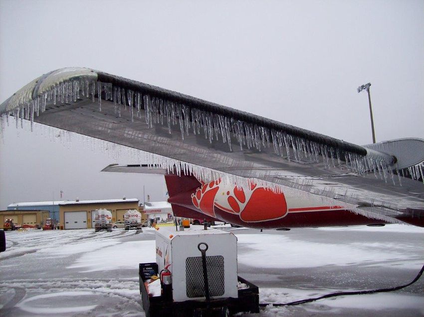
Introduction
The Aviation Weather Services Guide is designed to assist aviation users about
the availability and use of aviation weather products and services.
NAV CANADA is the private non-share capital corporation responsible for
providing civil air navigation services, including the aviation weather program
within Canadian airspace and Canadian-controlled oceanic airspace in the North
Atlantic to 30°W longitude.
For more detailed information on products and services, see:
the Meteorological (MET) section of the Transport Canada Aeronautical
Information Manual (TC AIM);
Manual of Standards and Procedures for Aviation Weather Forecasts
(MANAIR), which is available through the NAV CANADA Aviation Weather
Web Site;
the Air Command Weather Manual (and supplement); and
specific aerodrome information listed in the Canada Flight Supplement (CFS).
This guide is not an exhaustive review of aviation weather services. For more
information regarding aviation weather services or to order additional copies,
contact NAV CANADA Customer Service.
NAV CANADA
Customer Service
77 Metcalfe Street
Ottawa, ON K1P 5L6
Tel: 1-800-876-4693
Fax: 1-613-563-3426
service@navcanada.ca
www.navcanada.ca
Introduction Page | 1
Aviation Weather Services
NAV CANADA provides aviation weather services in support of aircraft
operations conducted in Canadian domestic airspace. Aviation weather
information is available through either an interpretative Pilot Briefing Service
(PBS) from Flight Information Centres (FIC) or via the Internet through the
NAV CANADA Aviation Weather Web Site (AWWS).
Pilot Briefing Service (PBS)
PBS is the provision of, or consultation on, meteorological and aeronautical
information to assist pilots in flight planning and includes a fully interpretive
weather briefing service provided by specially trained Flight Service Specialists
at FIC. Interpretation of changing or complex weather situations, special user
needs, consultation on specific weather problems, NOTAM and flight planning
services are all available from the FIC. Refer to the FLT PLN section of the CFS
Aerodrome Facility Directory for FIC contact information.
Aviation Weather Web Site (AWWS)
Internet access to Canadian aviation weather information is available through
the NAV CANADA Aviation Weather Web Site
(www.flightplanning.navcanada.ca). Canadian NOTAM and flight plan filing is
also available. American (U.S.) weather information, while not directly available
on the AWWS, is accessible through a link to the Aviation Digital Data Service
(ADDS) website.
The AWWS provides access to:
coded and plain language surface weather observations (METAR and SPECI)
aerodrome forecasts (TAF)
pilot weather reports (PIREP)
route specific alphanumeric information
weather charts
satellite and composite radar imagery
plotted wind and temperature charts
NOTAM; weather cameras
live runway visual range (RVR)
supplemental and reference information
Page | 2
The Aviation Weather Web Site consists of 5 sections, each accessible by
         selecting the corresponding tab in the lower portion of the NAV CANADA banner
         at the top of the page.
         My WX Data/Wx Mail     Personal weather information page that enable users to save up
                                to 10 customized weather information folders; flight dispatchers
                                can save up to 50. Saved weather information can be
                                configured for email dissemination on a user-scheduled basis.
                                Pilots must subscribe to use this feature.
         Route Data             Enable users to retrieve weather information along a proposed
                                flight route by specifying the departure, destinations and
                                enroute airports.
         Regional Area Data     Retrieves user-selected weather information for one of seven
                                GFA regions.

         Local Data             Retrieves user-selected weather information within a 50
                                nautical mile (NM) radius of a selected aerodrome.

         Forecasts and          The default page for the Web Site, which provides direct access
         Observations           to all available weather information.

         A link to the new Collaborative Flight Planning System (CFPS) for flight planning
         and graphical depiction of weather is available on the Aviation Weather Web Site.
         Whether you choose to self-brief on the Aviation Weather Web Site, call a FIC
         briefer or a combination of both is up to you. However, you should keep in mind
         that the FIC briefer has advanced weather training and meteorological products
         and tools which allow them to provide a professional interpretation of weather
         conditions tailored for your particular flight situation. Most pilots find that
         contacting a briefer is particularly beneficial when facing complex or rapidly
         changing weather conditions.

Aviation Weather Services                                                                 Page | 3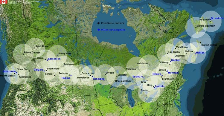
Flight Information Centres (FIC)
           Pilot Briefing Service (PBS)

Page | 4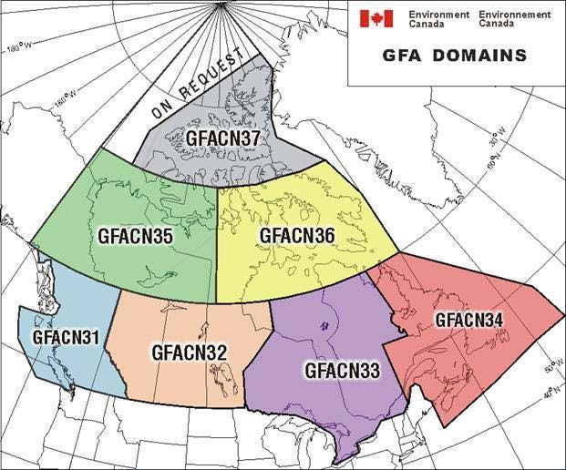
Flight Plan Processing Regions

          FICs provide pre-flight and flight information services enroute (FISE), pilot
          weather briefings, meteorological information, aeronautical information,
          aeronautical broadcasts, flight planning and VFR alerting, flight regularity
          message service, and other associated information services.
          For access to services provided by the FIC, the following telephone numbers are
          available toll-free within Canada only:

          1-866-WXBRIEF (1-866-992-7433)       Calls to this number are routed to the FIC serving
                                               the area from where the call originates.
          1-866-GOMÉTÉO (1-866-466-3836)       All calls to this number are routed to Québec FIC,
                                               which provides of bilingual services.

Flight Information Centres (FIC)                                                           Page | 5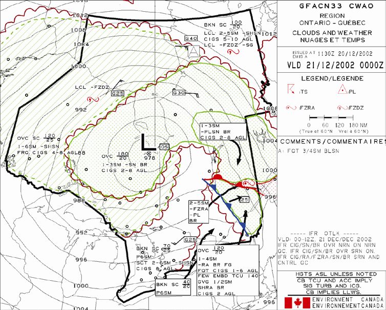
Should you experience problems connecting to a FIC via 1-866-WXBRIEF/
GOMÉTÉO, these numbers provide direct access to specific FIC from within
Canada and the continental United States.
Kamloops 1-866-541-4101
Edmonton 1-866-541-4102
Winnipeg 1-866-541-4103
London 1-866-541-4104
Québec (bilingual service) 1-866-541-4105
Halifax 1-866-541-4106
Services that are specific to an aerodrome – such as airport advisory, vehicle
control or local weather observations – will continue to be provided locally
through the existing NAV CANADA Flight Service Station (FSS) network.
Weather Briefing Tips
To obtain a good weather briefing, start with the “big weather picture”. While it
may be tempting to begin with the detailed weather reports and forecasts,
making sure you first have an appreciation of the synoptic-scale weather
situation will enable you to better understand how current and future weather
conditions may affect your flight.
A common practice amongst many pilots is to use the NAV CANADA Aviation
Weather Web Site to get an appreciation of general weather conditions prior to
contacting the FIC for a briefing.
When you’re ready to call the FIC, these steps can help you prepare for the call:
Have a pen and paper handy for making notes during the briefing.
Familiarize yourself with the general weather situation.
Make note of any questions you would like to ask the briefer.
Have relevant information about your flight handy.
Page | 6The job of the briefer is to select pertinent information for your flight. To do this
effectively, briefers need to understand as much as possible about your
proposed flight. The briefer will require the following information from you:
Is this an initial or update briefing
If it’s an update, when did you receive your previous briefing
Type of operation (e.g., IFR, VFR, etc.)
Type of flight (e.g., local, cross-country, photo flight)
Aircraft registration / flight number
Type of aircraft
Departure point, intended route and destination (alternate if applicable)
Proposed time of departure
Planned altitude
Estimated time enroute
Other pertinent information
As weather conditions constantly change and FIC service demands vary
throughout the day, briefers may have to place your call on hold while preparing
your briefing information. This is normal and sometimes necessary to ensure the
most accurate and up-to-date information.
If you’re a relatively new or inexperienced pilot or unfamiliar with the area over
which you’ll be flying, let the briefer know. This will help the briefer tailor the
content of the briefing to your requirements. If at any time during the briefing
something is unclear to you, don’t hesitate to ask for clarification. Remember, if
you don’t ask questions, the briefer will assume that you have understood
everything.
Pilot Briefing Format
The briefer normally follows a prescribed format and sequence when providing
you pre-flight information:
Significant meteorological and aeronautical information
Description of major weather features
Forecast weather summary
Route winds and temperatures
Detailed weather information
Supplementary aeronautical information (e.g., NOTAM)
Briefing review and updates
PIREP request
Flight Plan if required
Flight Information Centres (FIC) Page | 7Flight Plan Form
It is good practice to familiarize yourself with the content and format of a flight
plan before calling the briefer to file one. More information can be found in the
TC AIM or the CFS.
Trans-Border Flights
If you are planning a trans-border flight here’s a few important things to know
before you go:
In Canada, briefers provide any U.S. weather information available to them;
however, you are encouraged to contact an American Automated Flight Service
Station (AFSS) for an update briefing as soon as possible after entry into the US.
If you’re calling a Canadian FIC while in the US, please keep in mind that the
briefer is permitted to provide you only with weather information for the
Canadian portion of your return trans-border trip.
When you file a VFR flight plan in Canada, it is automatically opened at the
estimated time of departure (ETD) even if you fail to activate it. In US your filed
flight plan is opened only when activated with an AFSS by the pilot directly.
Sound Weather Judgment
Know before you go! Familiarize yourself with all significant weather conditions
before you begin your flight as follow
Start monitoring the weather a day or so prior to your intended flight. This will
provide you with a general weather trend of how weather conditions are
evolving.
Make your Go / No-Go decision based on the inclement weather you may face.
Remember only YOU can make this decision: the briefer will provide you with
the information but the responsibility for proceeding with the flight rests solely
with you.
Page | 8In-Flight Weather
In-flight weather information provided to pilots is primarily intended to meet the
need for brief updates of destination, alternate, and enroute weather.
Air Traffic Control (ATC) – ATC may provide local weather information, time
permitting.
Flight Service Station (FSS) – FSS provide services that are specific to an
aerodrome. Local weather information is available to assist arriving and
departing aircraft.
Flight Information Centre (FIC) – FICs provide fully interpretive weather briefing
service for any area of Canada.
Automated Terminal Information Service (ATIS) – ATIS provides airport-specific
information including local weather, to arriving and departing aircraft by means
of a recorded continuous and repetitive broadcast. Refer to the CFS for ATIS
availability at specific airports.
Automated Weather Observation Systems (AWOS) and Limited Weather
Information Systems (LWIS) – AWOS and LWIS may transmit local weather
information on a designated VHF frequency.
In-Flight Weather Page | 9Aviation Weather Information
Weather information is disseminated as either alphanumeric data or graphic
weather products. Current weather information describes weather conditions
that have already occurred, whereas forecast weather products depict the most
likely weather conditions at some future time.
Weather Information
Alphanumeric Weather Data Graphic Weather Products
Current Weather Current Weather
Aerodrome Routine and Special Meteorological Analysis Charts (Surface & Upper Air)
Reports (METAR/SPECI) Weather Radar
Pilot Weather Reports (PIREPs) Satellite Imagery
Forecast Weather Forecast Weather
Aerodrome Forecast (TAF) Graphic Area Forecast (GFA)
Winds and Temperature Aloft Forecast (FD/FB) Significant Weather Charts
AIRMET Turbulence Charts
SIGMET Upper Level Wind Charts
Volcanic Ash Charts
Weather Product Summary
The products described in the following tables are routinely available to pilots
and dispatchers for flight planning and weather monitoring purposes.
Alphanumeric Weather Data
Product Issue Time / Coverage Description
Validity
Period
SIGMET As required - As specified in the Information message issued by a
4 hours. body of the SIGMET meteorological watch office (MWO) to
Volcanic ash advise pilots of the occurrence or
and tropical expected occurrence of specified
cyclone: valid weather phenomena, which may
for 6 hours affect the safety of aircraft operations,
and the development of those
phenomena in time and space.
AIRMET As required - As specified in the Information message issued by a
4 hours. Valid body of the meteorological watch office (MWO) to
until updated, AIRMET, up to and advise pilots of the occurrence or
cancelled, or including 24 000 expected occurrence of specified
a new GFA is feet weather phenomena which may affect
issued the safety of aircraft operations, which
were not already included in a
Graphic Area Forecast (GFA), and the
development of those phenomena in
time and space
Page | 10Alphanumeric Weather Data
PIREP When As reported by a Flight conditions, as reported by a
received from pilot pilot
a pilot
METAR Canadian on As observed from Actual weather conditions as
and the hour, the ground at the observed from the ground
SPECI SPECI when point of
required observation
TAF See CFS for Forecast for a Forecast of expected weather
issue times specific aerodrome conditions within 5 nautical miles of
and validity. the aerodrome
Normally
updated
every 6
hours; more
frequently for
larger airports
FB Twice daily, Low High Alphanumerical (text) forecast in
based on 00Z 3 000 ft FL240 tabular form of temperatures aloft for
or 12Z data. 6 000 ft FL300 specific altitudes
Valid for 24 9 000 ft FL340
hours 12 000 ft FL390
18 000 ft FL450
FL530
Graphic Weather Products
Product Issue Time / Coverage Description
Validity Period
Surface Analysis Four times daily: All of Canada, Surface analysis of
Chart valid 00Z, 06Z, 12Z, Alaska and the MSL pressure values,
18Z northern US fronts and detailed
station weather plots
Upper Air Analysis Twice daily: valid North American Height of constant
Chart 00Z and 12Z coverage: pressure levels, wind
850hPa (5 000 ft) velocity, temperature
700hPa (10 000 ft) and moisture
500hPa (18 000 ft)
250hPa(34 000 ft)
Aviation Weather Information Page | 11Graphic Weather Products
Graphic Area Issued four times National coverage Forecast depiction of
Forecast (GFA) daily: 00Z, 06Z, via seven regional weather conditions
Chart 12Z, 18Z – valid for charts: up to and including
12 hours with an GFACN31- Pacific 24 000 feet,
additional 12-hour GFACN32 - Prairies consists of three
IFR outlook GFACN33 - Ont / Clouds and Weather
Que charts and three Icing,
GFACN34 - Atlantic Turbulence and
GFACN35 - Yukon Freezing Level charts
GFACN36 -
Nunavut
GFACN37 - Arctic
Local Graphic Issued four times Local coverage of Forecast depiction of
Forecast (LGF) daily: 15Z, 18Z, 21Z, specific geographic weather conditions
Chart 00Z – valid for 6 areas (e.g., West below 10 000 ft,
hours. Last LGF Coast VFR LGF) tailored to meet local
includes Outlook need. Supplements
for the next the GFA
morning
Significant Four times daily: Coverage varies by Forecast depiction of
Weather Prognosis valid 00Z, 06Z, 12Z, product significant weather
Chart 18Z High-level, FL250- conditions (e.g.,
600 (400-70hPa) thunderstorms, icing,
Mid-level, FL100- turbulence
250 (700-400hPa)
N. Atlantic, Sfc-
FL250 (SFC-
400hPa)
Volcanic Ash As required As required Forecast depiction of
Forecast Chart expected ash cloud
dispersion (plume)
Upper Level Wind Twice daily: valid Coverage varies by Forecast depiction of
and Temperature 00Z, 06Z, 12Z, 18Z product: available wind and
Forecast Chart for FL240, FL340, temperatures aloft
FL390, FL450
Turbulence Twice daily: valid National and North Forecast depiction of
Forecast Chart 00Z, 12Z Atlantic coverage MDT and SEV
turbulence (jet stream
/ convective)
between FL280-
FL430
Page | 12Weather Imagery and Supplementary Products
Product Issue Time / Validity Coverage Description
Period
Weather Radar Images updated every Line of sight Composite or single-
Imagery 10 minutes from radar site display of either
within a limited precipitation intensity
horizontal range or height of echo tops
Satellite Imagery Geostationary (GOES) Coverage varies GOES and POES
satellite images with product satellites provide
updated every 30 chosen both Infrared (IR) and
minutes. Polar Visible (VIS) images
Orbiting (POES)
satellite images
updated approx. every
6 hours
Weather Cameras Images updated every Fixed viewing Colour picture of
10 minutes angles local weather
conditions; date and
time of each image
superimposed. Local
METAR displayed, if
available
Aviation Weather Information Page | 13Aviation Weather Observation Products
Canada has more than 230 surface weather observation sites. At each site,
weather data is routinely collected by either a human observer or a suite of
automated sensors, and are then coded into weather observations for
dissemination.
Surface Weather Observations (METAR / SPECI / LWIS)
Routine surface weather observations taken on the hour are disseminated as
METARs. SPECIs are special weather observations, issued at times other than on
the hour, as the result of significant weather changes. If a METAR or SPECI is
taken by a suite of automated sensors, it is denoted as an “AUTO” observation in
the body of the report.
Two types of automated weather stations are used for aviation purposes: the
Automated Weather Observation System (AWOS) and the Limited Weather
Information System (LWIS).
AWOS has a full suite of sensors that measures cloud base height, sky cover,
visibility, temperature, dew point, wind velocity, altimeter setting, precipitation
occurrence, type, amount and intensity, and icing. LWIS is a more basic
automated weather system, measuring only wind, altimeter setting, temperature
and dew point. Either system may be equipped with a voice generation module.
Page | 14Canadian surface weather observations programs, systems, and equipment
METAR METAR and SPECI weather observations taken by qualified human
observers. METAR hours are included and sites operating 24 hours a day
are listed as METAR (H24)
METAR AUTO METAR and SPECI weather observations are taken by stand-alone
Automated Weather Observation System (AWOS) with noted
enhancements. AWOS systems located outside the Canadian Lightning
Detection Network coverage area do not receive lightning data and
therefore are unable to report thunderstorm or lightning activity. AWOS
hours are included. Sites operating 24 hours a day are listed as METAR
AUTO (H24). Examples of METAR AUTO stations are the NAV CANADA
AWOS (NC AWOS) and DND AWOS.
LWIS Limited Weather Information System is automated weather system that
produces an hourly report containing wind speed, direction,
temperature, dew point and altimeter setting only LWIS hours are
included and sites operating 24 hours a day will be listed as LWIS (H24)
AUTO This is an automated weather system that reports a variety of weather
elements, but does not meet requirements to produce a METAR, SPECI
or LWIS report. These systems can report a variety of observed weather
elements. For further information, contact the aerodrome operator for
further information.
WxCam A NAV CANADA aviation weather camera is installed at the site. Images
are transmitted to the NAV CANADA Aviation Weather Web Site at 10-
minute intervals
Webcam One or more cameras not belonging to NAV CANADA have been
installed at this location. For further information, contact the aerodrome
operator.
Stand-alone METAR AUTO and LWIS reports are available during published
hours through normal meteorological information systems. At some sites an
automated voice broadcast of the latest observation is available via VHF
transmitter. In these cases, the VHF frequency is displayed in the COMM box
(e.g., COMM AWOS 124.7, COMM AUTO 122.025).
The hours of coverage for METAR, METAR AUTO, and LWIS are indicated (e.g.
METAR 09-21Z). At sites where coverage is 24 hours, the coverage is listed as
H24 (e.g. METAR H24, METAR AUTO H24). At sites where there is a combination
of weather programs, the coverage will be listed as METAR xx-xxZ O/T METAR
AUTO or LWIS (e.g. METAR 12-20Z O/T LWIS).
All aviation weather observations and aviation weather camera images are
available on the NAV CANADA Aviation Weather Web Site (AWWS) at
www.flightplanning.navcanada.ca.
Aviation Weather Observation Products Page | 15AWOS and LWIS
NAV CANADA’s automated weather system network (AWOS and LWIS) includes
the following features:
AWOS and LWIS
Enhancement Description AWOS LWIS
Thunderstorms reported at sites within the domain of the Canadian Y
Lightning Detection Network. Thunderstorm activity, based on the
proximity of the lightning strike(s) to the site, are reported as:
TS Thunderstorm (at site), if lightning detected at 6sm or
less
VCTS Thunderstorm in the Vicinity, if lightning detected
from >6-10SM
LTNG DIST (direction) if lightning detected from >10 - 30SM,
Lightning Distant with octant compass cardinal
direction is reported in Remarks e.g., LTNG DIST NE,
S, SW
LTNG DIST ALL Lightning Distant All Quadrants is reported in
QUADS Remarks if lightning detected in four or more octant
Ice-resistant anemometer technology employed Y Y
Density altitude reported Y
Laser ceilometer can report cloud bases up to 25 000 feet Y
Improved AWOS can report Haze (HZ); Mist (BR); Fog (FG); Y
Obstructions to Freezing Fog (FZFG); and Blowing Snow (BLSN)
Vision reporting
capability
Runway Visual Range (RVR) reported at sites equipped with RVR sensors Y
Specific remarks will be added whenever data is missing Y
CLD MISG sky condition (cloud) data missing
ICG MISG icing data missing
PCPN MISG precipitation data missing
PRES MISG pressure (altimeter) data missing
RVR MISG RVR data missing
T MISG temperature data missing
TD MISG dew point temperature data missing
TS/LTNG TEMPO thunderstorm/lightning data missing
UNAVBL
VIS MISG visibility missing
WND MISG wind missing
WX MISG weather data missing
Page | 16METAR Decode and Description
METAR CYXE 292000Z CCA 30015G25KT 3/4SM R33/4000FT/D -RA BR BKN008 OVC040
21/19 A2992 WS RWY33 RMK SF5NS3 VIS NW 3/8 SLP134 DENSITY ALTITUDE 2500FT
METAR Type of Report - METAR
Aerodrome Routine Meteorological Report (METAR) taken on the
hour
SPECI indicates that the observation was taken other than on the
hour because of a significant change to previously reported weather
conditions
CYXE Station Identifier – Saskatoon, Saskatchewan
The station identifier is indicated using the four-letter ICAO site code.
292000Z Date/Time of Issue – 29th day of the month, 2000 UTC
CCA Report Modifier – Corrected weather observation
The letters CCA are used to indicate the first correction, CCB for
second and so on
AUTO indicates that the observation was taken by an AWOS
30015G25KT Surface Wind – 300° true at 15 knots gusting to 25 knots
The two-minute mean wind direction (to the nearest 10° True) and
wind speed (to the nearest knot). Calm winds are indicated as
00000KT
Peak gust speeds are preceded by the letter G; squalls by the letter
Q.
3/4SM Prevailing Visibility – 3/4 statute miles
Statute Miles (SM) and fractions of SM with no maximum visibility
value are reported (AWOS sites report a sensor-equivalent visibility)
R33/4000FT/D RVR – For runway 33 is 4 000 feet with a downward tendency
The 10-minute mean RVR is reported for the touchdown zone when
the prevailing visibility is 1 mile or less and/or the RVR is 6 000 feet
or less
When the RVR varies significantly prior to the reporting period, the 1-
minute mean maximum or minimum value is reported prefixed by a
V. The following suffixes is used to indicate the RVR tendency
/U to indicate an upward trend
/D to indicate a downward trend
/N to indicate no change
-RA BR Present Weather - Light rain and mist
Present weather is composed of weather phenomenon (precipitation,
obscuration or others), which may be preceded by one or two
qualifiers (intensify or proximity to the station and descriptor)
The dominant weather phenomenon is reported first
Aviation Weather Observation Products Page | 17METAR CYXE 292000Z CCA 30015G25KT 3/4SM R33/4000FT/D -RA BR BKN008 OVC040
21/19 A2992 WS RWY33 RMK SF5NS3 VIS NW 3/8 SLP134 DENSITY ALTITUDE 2500FT
BKN008 OVC040 Sky Condition - The cloud layer at 800 feet is broken, covering from
5/8 to 7/8 of the observed sky. The next cloud layer at 4 000 feet,
combined with the lower cloud layer, is overcast covering 8/8 of the
sky, as observed from the ground
Clouds are reported based on the summation amount of each cloud
layer as observed from the surface up. The layer amounts are
reported in eighths of sky coverage (oktas) as follows:
SKC no cloud (AWOS reports CLR if no cloud below 25 000 ft)
FEW >0 to 2 oktas of cloud
SCT 3 to 4 oktas of cloud
BKN 5 to 7 oktas of cloud
OVC 8 oktas of cloud
Only CB and TCU clouds will be appended to a layer. An obscured
sky is reported as vertical visibility (VV) in hundreds of feet
21/19 Temperature - 21° C, dew point - 19° C
Temperature and dew point are reported to the nearest whole
degree Celsius. The letter M will precede negative values
A2992 Altimeter Setting – 29.92 inches of mercury
The letter A prefixing the 4-digit number group indicates inches of
mercury for altimeter setting
WS RWY 33 Winds Shear - Wind shear reported in the takeoff or landing path of
Runway 33 at 1 500 feet AGL and below
Wind shear information at 1 500 feet AGL and below will be provided
when reported by an aircraft (usually on takeoff or landing)
RMK SF5NS3 Remarks - The lowest reported cloud layer type is stratus fractus
with an amount of 5 oktas; the next cloud layer is nimbostratus with
an amount of 3 oktas
Where observed, the obscuration and cloud type amount for each
reported layer is included in remarks. It may exceed 8 oktas if a
higher layer is observed through transparencies in a lower layer
VIS NW 3/8 Supplementary Remarks - Visibility to the northwest is 3/8 statute
mile
Other supplementary remarks of operational significance may be
included using standard meteorological abbreviations
SLP134 Mean Sea Level (MSL) Pressure - 1013.4 hPa.
The MSL pressure, reported to the nearest tenth of an hPa is always
the last field of the METAR report, prefixed with SLP. The MSL
pressure is reported in an abbreviated coded form
If the coded MSL pressure value starts with a 9, 8, or 7, add the
number “9” to the beginning (e.g., 880 becomes 988.0)
If the coded MSL pressure value starts with a 0, 1, 2, or 3, add the
number “10” to the beginning (e.g., 134 becomes 1013.4)
DENSITY ALTITUDE Density Altitude 2 500 ft
2500FT This remark is only added when the density altitude is 200 ft or
higher than the aerodrome elevation.
Page | 18LWIS CYLA 292000Z AUTO 31006KT M00/M02 A2926
LWIS Limited Weather Information System (LWIS) taken on the hour.
CYLA Station Identifier – Aupaluk, Quebec
The station identifier is indicated using the four-letter ICAO site code
292000Z Date/Time of Issue – 29th day of the month, 2000 UTC
AUTO AUTO indicates that the observation was taken by an AWOS
31006KT Surface Wind – 310° true at 6 knots
The two-minute mean wind direction (to the nearest 10° True) and
wind speed (to the nearest knot). Calm winds are indicated as
00000KT
Peak gust speeds are preceded by the letter G; squalls by the letter Q
01/M02 Temperature - 1° C, dew point - minus 2° C
Temperature and dew point are reported to the nearest whole degree
Celsius. The letter M will precede negative values
A2926 Altimeter Setting – 29.26 inches of mercury
The letter A prefixing the 4-digit number group indicates inches of
mercury for altimeter setting
Aviation Weather Observation Products Page | 19Significant Present Weather Codes
Weather Codes
Qualifier Weather Phenomena
Intensity or Descriptor Precipitation Obscuration Other
Vicinity
DZ Drizzle BR Mist PO Dust/sand
(VIS Whirls
5/8-6 (Dust
SM) Devils)
Note: MI Shallow RA Rain FG Fog SQ Squalls
Precipitation (Vis <
Intensity refers 5/8 SM)
to all forms
combined
BC Patches SN Snow FU Smoke +FC Tornado or
(VIS ≤ 6 Waterspout
SM)
- Light PR Partial SG Snow DU Dust FC Funnel
Grains (VIS ≤ 6 Cloud
SM)
Moderate DR Drifting IC Ice SA Sand SS Sandstorm
(no qualifier) Crystals (VIS ≤ 6 (VIS < 5/8
SM) SM)
+ Heavy BL Blowing PL Ice HZ Haze +SS Heavy
Pellets (VIS ≤ 6 Sandstorm
SM) (Vis ≤ 1/4
SM)
SH Showers (s) GR Hail VA Volcanic DS Duststorm
Ash (VIS < 5/8
(With SM)
any VIS)
TS Thunderstorm GS Snow Pellets +DS Heavy
Duststorm
(Vis ≤ 1/4
SM)
FZ Freezing UP Unknown
Precipitation
(AWOS only)
Page | 20Cloud Type Abbreviations
Abbreviations for Cloud Types found in RMK section of METAR
Low Clouds Middle Clouds High Clouds
CB Cumulonimbus AS Altostratus CI Cirrus
TCU Towering Cumulus AC Altocumulus CS Cirrostratus
CU Cumulus ACC Altocumulus Castellanus CC Cirrocumulus
CF Cumulus Fractus
SC Stratocumulus
NS Nimbostratus
ST Stratus
SF Status Fractus
Density Altitude
Density altitude is a measure of air density. It is not to be used as a height
reference, but as determining criteria in the performance capability of aircraft.
Air density decreases with altitude. As air density decreases, density altitude
increases. The further effects of high temperature and high humidity are
cumulative, resulting in an increasing high density altitude condition.
Effects of Density Altitude: High density altitude reduces all aircraft performance
parameters. To the pilot, this means that the normal horsepower output is
reduced, propeller efficiency is reduced, and a higher true airspeed is required to
sustain the aircraft. It means an increase in runway length requirements for
takeoff and landings, and decreased climb rate. For example, an aircraft,
requiring 1 000 feet for takeoff at sea level under standard atmospheric
conditions requires a take-off run of approximately 2 000 feet at an operational
altitude of 5 000 feet.
Note: A turbo-charged aircraft engine provides some slight advantages: it
provides sea-level horsepower up to a specified altitude.
Aviation Weather Observation Products Page | 21Pilot Weather Report (PIREP)
PIREPs are reports of weather conditions by pilots in flight and are extremely
useful to forecasters, weather briefers, and other pilots. Often the PIREP
provides the only weather information. Even on good weather days, PIREPs are
helpful for validating forecasts and assisting other pilots with flight planning
decisions. PIREPs are distributed using standard meteorological abbreviations
(Abbreviations are covered later in this guide). Recent PIREPs that contain
weather elements that could be hazardous for other aircraft are broadcast
immediately by air traffic services. PIREPs are available in both coded form and
plain language on the NAV CANADA Aviation Weather Web Site.
It is highly recommended to pass PIREPs to the Flight Service Specialist whenever
possible during flight using 126.7 MHz or the discrete frequency or as soon as
feasible after landing. Flight service specialists accept pilot reports as provided by
the pilot, however, additional information may at times be requested.
Turbulence and Icing Reporting Tables
Turbulence Reporting
Intensity Aircraft Reaction Inside Aircraft
Light Slight erratic changes Slight strain against seat belts,
(turbulence) walking not difficult
Slight rhythmic changed (chop)
Moderate Changes to altitude/attitude but Definite strain against seat belts
aircraft remains in control Objects are dislodged
Rapid bumps or jolts (chop) Walking difficult
Severe Large, abrupt changes in Forced violently against seat belts
altitude/attitude and airspeed Walking impossible
Momentarily out of control Unsecured objects thrown about
Icing Intensity Reporting
Intensity Ice Accumulation
Trace Ice becomes perceptible. The rate of accumulation is slightly greater than
the rate of sublimation. It is not hazardous, even though de-icing or anti-
icing equipment is not used, unless encountered for an extended period
of time (over 1 hour)
Light If flight is prolonged in this environment (over 1 hour), the rate of
accumulation may create a problem
Moderate The rate of accumulation is such that even short encounters become
potentially hazardous, and use of de-icing or anti-icing equipment or
diversion is necessary
Severe The rate of accumulation is such that de-icing or anti-icing equipment
fails to reduce or control the hazard. Immediate diversion is necessary
Page | 22Icing Type Reporting
Type Description
Rime ice Rough, milky, opaque ice formed by the instantaneous freezing of small
super cooled water droplets
Clear ice Glossy, clear, or translucent ice formed by the relatively slow freezing of
large super cooled water droplets
Mixed ice Both rime and clear icing occurring at the same time.
Photo by Russ Wakshinski, FSS Timmins and
thanks to Bearskin Airlines
Aviation Weather Observation Products Page | 23PIREP Decode and Description
UACN10 CYXU 032133
YZ
UA /OV YXU 090010 /TM 2120 /FL080 /TP PA31 /SK 020BKN040 OVC110 /TA -12
/WV 030045 /TB MDT BLO 040 /IC LGT RIME 020-040 /RM NIL TURB CYYZ-CYHM
UACN10 PIREP Type – Regular Priority
Urgent PIREP are encoded as UACN01
CYXU Station Identifier – Issuing Office
PIREP issued by London FIC
032133 Date/Time of Issue (UTC)
PIREP was issued on the 3rd day of the month at 2133UTC
YZ Flight Information Region (FIR)
Toronto FIR. If the PIREP extends into an adjacent FIR, both FIRs
are indicated
UA PIREP Designator
An urgent PIREP is indicated using the designator UUA
/OV YXU 090010 Location
London VOR 090° radial, 10 NM. PIREP location is reported with
reference to a NAVAID, airport or geographic coordinates (latitude
/ longitude)
/TM 2120 Time of PIREP
PIREP was reported at 2120 UTC
/FL080 Flight Level
Altitude is 8 000 ft ASL. Altitude may also be reported as DURD
(during descent), DURC (during climb) or UNKN (unknown)
/TP PA31 Aircraft Type
Piper Navajo. Designator of aircraft reporting the PIREP
/SK 020BKN040 Sky Cover
OVC110 Two layers of cloud have been reported. First layer of cloud based at 2 000
ft with tops at 4 000 ft ASL. Second layer of cloud tops at 11 000 ft ASL
/TA -12 Air Temperature
The air temperature at 8 000 ft ASL is reported as -12° Celsius
/WV 030045 Wind Velocity
Wind direction 030° degrees true; wind speed 45 knots. Wind
direction reported in degrees magnetic will be converted to
degrees true
/TB MDT BLO 040 Turbulence
Moderate turbulence reported below 4 000 ft ASL
/IC LGT RIME 020- Icing
040 Light rime icing (in cloud) reported between 2 000 ft ASL and
4 000 ft ASL
/RM NIL TURB CYYZ- Remarks
CYHM No turbulence encountered between Toronto and Hamilton
Page | 24AIRMET
AIRMET: Information message issued by a meteorological watch office (MWO) to
advise pilots of the occurrence or expected occurrence of specified weather
phenomena that may affect the safety of aircraft operations, which were not
already included in a Graphic Area Forecast (GFA), and the development of those
phenomena in time and space.
AIRMET is issued for the following phenomena:
SFC WND SPD widespread mean surface wind speed above 30 KT
Surface visibility and/or cloud less than 3SM and/or BKN or OVC below
1 000 ft AGL over a widespread area
Thunderstorm (TS) and/or Towering cumulus (TCU) TCU if ISOLD, OCNL,
FRQ; or either of the following:
TS if ISOLD, OCNL, with hail as necessary
Both TS and TCU if both are present and the spatial amount of the TCU
exceeds that of the TS, with the cumulative spatial amount not exceeding
100%. Otherwise only the TS is reported
Turbulence (TURB) only MDT
Icing (ICG) only MDT
Mountain waves (MTW) only MDT
Aviation Weather Observation Products Page | 25AIRMET Decode and Description
WACN23 CWAO 162225
CZWG AIRMET A1 VALID 162225/170225 CWEG
CZWG WINNIPEG FIR ISOLD TS OBS WTN 20NM OF LINE /N4929 W09449/25 SW
CYQK – N5104 W09348/CYRL – N5209 W09120/60NW CYPL TOP FL340 MOV E
15KT NC
RMK GFACN33
WACN23 AIRMET (WA)
For Canadian Airspace (CN)
For Winnipeg FIR (23)
CWAO World Meteorological Organization (WMO) Header
International four-letter location indicator of the centre
originating or compiling the bulletins
162225 Date/Time of Issue (UTC)
AIRMET issued on the 16th day of the month at 2225Z
AIRMET A1 Bulletin Number
The first AIRMET issued for this weather phenomenon within
the Winnipeg FIR
VALID 162225/170225 Validity Period
CWEG AIRMET valid for four hours; from the 16th day of the month
at 2225Z until the 17th day of the month at 0225Z, was
issued by MWO at the Canadian Meteorological Aviation
Centre - West (CMAC-W) in Edmonton. CWUL indicates
CMAC-E in Montreal
ISOLD TS OBS Description of the Phenomenon
Isolated thunderstorms observed
WTN 20NM OF LINE Location of the Phenomenon
/N4929 W09449/25SW Within 20 nautical miles of a line from 25 miles southwest of
CYQK - /N5104 Kenora (N4929 W09449 CYQK) to Red Lake (N5104
W09348/CYRL – N5209 W09348 CYRL) to 60 nautical miles northwest of Pickle
W09120/60 NW CYPL Lake (N5209 W09120 CYPL)
TOP FL340 Flight Level and Extent
Tops of the thunderstorms extends to Flight Level 340
MOV E 15KT Movement or Expected Movement
The isolated thunderstorms are moving east at 15 knots
NC Change in Intensity
No change in intensity expected
RMK GFACN33 Remarks
Phenomenon is forecast within the GFACN33 domain
Page | 26SIGMET
A SIGMET is an information message issued by a meteorological watch office
(MWO) to advise pilots of the occurrence or expected occurrence of specified
weather phenomena, which may affect the safety of aircraft operations, and the
development of those phenomena in time and space.
SIGMETs come in three types:
WS SIGMET for thunderstorm, turbulence, icing, mountain waves, low level
wind shear, dust storms, sand storms, and radioactive cloud
WC SIGMET for tropical cyclone (TC).
WV SIGMET for volcanic ash (VA)
SIGMET will be issued for the following phenomena (with only one phenomenon
in each SIGMET):
Thunderstorm (TS): FRQ or SQLN, with hail, tornado/waterspout as
necessary
Turbulence (TURB): only SEV
Icing (ICG): only SEV with or without FZRA
Mountain waves (MTW): only SEV
Low Level wind shear (LLWS)
Dust storm (DS): only HVY
Sand storm (SS): only HVY
Radioactive cloud (RDOACT CLD)
Aviation Weather Observation Products Page | 27SIGMET Decode and Description
WSCN23 CWAO 162225
CZWG SIGMET A4 VALID 162225/170225 CWEG
CZWG WINNIPEG FIR WTN SQLN TS OBS WTN 20NM OF LINE /N4929 W09449/25
SW CYQK – N5104 W09348/CYRL – N5209 W09120/60NW CYPL TOP FL340 MOV E
15KT NC
RMK GFACN33
WSCN23 SIGMET Type (WS)
For Canadian Airspace (CN)
For Winnipeg FIR (23)
CWAO World Meteorological Organization (WMO) Header
International four-letter location indicator of the centre
originating or compiling the bulletins
162225 Date/Time of Issue (UTC)
Issued on the 16th day of the month at 2225UTC
SIGMET A4 Bulletin Number
Supersedes its predecessor A3, which was issued by the
same weather centre to describe the same weather
phenomenon within the Winnipeg FIR
VALID 162225/170225 Validity Period
CWEG SIGMET valid for four hours; from the 16th day of the month
at 2225Z until the 17th day of the month at 0225Z and was
issued by Meteorological Watch Office (MWO) at the
Canadian Meteorological Aviation Centre - West (CMAC-W)
in Edmonton. CWUL indicates CMAC-E in Montreal
CZWG WINNIPEG FIR Location Indicator and Name of the FIR
CZWG for the Winnipeg FIR
SQLN TS OBS Description of the Phenomenon
A squall line of thunderstorm is observed
WTN 20NM OF LINE Location of the Phenomenon
/N4929 W09449/25SW Within 20 nautical miles of a line from 25 miles southwest of
CYQK - /N5104 Kenora (N4929 W09449 CYQK) to Red Lake (N5104
W09348/CYRL – N5209 W09348 CYRL) to 60 nautical miles northwest of Pickle
W09120/60 NW CYPL Lake (N5209 W09120 CYPL)
TOP FL340 Flight Level and Extent
The top of the squall line of thunderstorms extends to Flight
Level 340
MOV E 15KT Movement or expected movement
The squall line of thunderstorms is moving east at 15knots
NC Change in Intensity
No change in intensity is expected
RMK GFACN33 Remarks
Phenomenon is forecast within the GFACN33 domain
Page | 28Weather Radar
Weather radar is an important tool that assists identifying areas of precipitation.
Note that weather radar does not show cloud cover. Pilots unfamiliar with
interpreting weather radar products are advised to seek the assistance of a
briefer.
Weather radar imagery is disseminated in two formats: a precipitation intensity
product and an echo tops product. The radar product provides an indication of
precipitation intensity, measured in mm or cm/hr rate of fall, at a specific
altitude (e.g. 1.5 km). Two settings are used for the scale, one for rain with a scale
of up to 300 mm/hr and one for snow with a rate of fall of up to 40 cm/hr. The
echo tops radar product provides an indication of the vertical extent of the
precipitation area. Cloud tops could extend much higher.
Each weather radar site has a detection range of approximately 150 NM.
Weather radar composite products integrate a number of individual radar
images into a single product. The advantage of the composite product is that
radar anomalies such as signal attenuation and masking are reduced because
adjacent radar sites can “see” the precipitation area from other directions.
Weather radar composite products and individual radar site images are available
in colour on the NAV CANADA Aviation Weather Web Site.
Aviation Weather Observation Products Page | 29Satellite Imagery
Two of the most common types of satellite imagery—visible (VIS) or infrared (IR)—
are available on the NAV CANADA Aviation Weather Web Site. Satellite images
are taken from either geostationary or polar orbiting weather satellites.
GOES satellites orbit the Earth at about 36,000 km of altitude over the equator.
Their position does not change with respect to a point on the surface of the
earth. POES satellites with High-Resolution Picture Transfer (HRPT) orbit the
earth at an altitude of approximately 850 km. Completing one orbit every 105
minutes, the satellites circle the earth 14 times a day. Because of the orbital shift
resulting from the planet's rotation, they move west by approximately 2 time
zones per orbit.
Page | 30Visual A photo of the clouds during daylight hours
Infra-red Measuring the heat (thermal) footprint of areas of cloud or the earth’s
surface if clouds are thin or absent, can be used both day and night
Owing to the complexity of interpreting satellite imagery, most pilots should
consider consulting a briefer when considering the use of satellite products for
flight planning purposes.
Surface Analysis Chart
Aviation Weather Observation Products Page | 31The Meteorological Service of Canada produces a national surface analysis chart
4 times per day, valid at 00Z, 06Z, 12Z and 18Z. few points to remember when
using surface analysis weather charts:
Isobars, curving lines joining points of equal mean sea level (MSL) pressure,
are analysed at 4 hPa intervals from a 1000 hPa reference value.
Winds tend to veer and increase with altitude. Above 3 000 ft AGL, winds
tend to blow roughly parallel to the isobars. When the isobars are spaced
closer together, winds are stronger.
Fronts indicate the transition zone between two air masses and are depicted
by either blue lines with barbs (cold front) or red lines with half circles (warm
front).
Fronts advance in the direction of their pointed barbs (cold front) or half
circle (warm front) symbols. A front that is not advancing is said to be quasi-
stationary. A TROWAL is a trough of warm air aloft.
Upper Air Analysis Charts
Upper air weather charts, also referred to as constant pressure charts, differ
from surface weather charts, such as the surface analysis chart, which displays
weather information at the same geometric altitude above sea level (ASL). The
altitude of the pressure level depends upon the density, and hence the
temperature, of the intervening air column. Since air expands as it is heated, in
regions where the air is cold and dense, the altitude of the pressure level will be
lower than over a region where the air is warmer and less dense.
The depicted information on constant pressure charts is based on temperature,
humidity and wind data gathered from radiosonde balloons and is
supplemented with data from aircraft reports and satellite-derived wind data in
the more remote regions.
On constant pressure charts the level pressure is the same everywhere on the
chart, just as the name implies. What varies on these charts is the altitude of the
specific pressure level. Each chart represents a constant pressure level, so it is
analyzed for altitude or height in decameters above mean sea level. Lines,
known as contours, are similar to isobars on surface weather charts; but these
lines connect points of equal height for the particular pressure level. Contours
are analyzed the same way as isobars; the closer the spacing of the contours,
the stronger the wind speed.
Page | 32Constant pressure charts are prepared by computers twice daily, at 00Z and 12Z
for several mandatory pressure levels in the atmosphere. The approximately
height of each constant pressure chart and the associated pressure level is listed
below:
850 hPa chart 5 000 feet ASL
700 hPa chart 10 000 feet ASL
500 hPa chart 18 000 feet ASL
250 hPa chart 34 000 feet ASL
Aviation Weather Observation Products Page | 33Aviation Weather Forecast Products
Aerodrome Forecast (TAF)
Aerodrome Forecasts (TAF) are produced for approximately 195 sites across
Canada. See AIM MET for locations. Abbreviations and codes in the TAF are the
same as those used in the METAR.
Valid Period - Canadian TAF have various validity periods and can be valid for up
to 30 hours. In the Canadian TAF, a validity period that ends at midnight UTC is
coded as 2400Z (2912/2924). A TAF validity period that begins at midnight UTC
is coded as 0000Z (3000/3018).
Change Groups are used to indicate the time of an expected weather change.
They are FM, BECMG, TEMPO, and PROB30/40. A permanent change group such
as FM or BECMG is definite while a temporary change group like TEMPO is
transitory. PROB indicates a probability of a weather event (not that a weather
event occurs for a percentage of the time).
FM (for From) – FM230600Z
Means FROM 0600Z, and is used when a permanent change to the forecast
occurs rapidly. Any forecast conditions given before FM are superseded.
BECMG (for Becoming) - BECMG 2906/2908
Means BECOMING during the period 06Z to 08Z, and is indicated when a
permanent change is expected to occur over 1-4 hours. Normally this is used
when only one or two weather groups are expected to change with the others
remaining the same.
TEMPO (for Temporary) - TEMPO 1306/1312
Means TEMPORARY FLUCTUATION between 06Z and 12Z, and is indicated when
a transitory change in some or all weather elements is expected during a
specified time period. Only used when condition is forecast to last less than one
hour at a time, and does not cover more than half the indicated forecast period.
PROB (for Probability) - PROB30 0806/0812
Means PROBABILITY 30% (or 40%) between 06Z and 12Z that a given weather
condition may occur. In the example above, it means a 30% chance of the
condition occurring between 06Z and 12Z, not that a given weather condition
occurs 30% of the time.
IFR Alternate Selection Criteria - When selecting an alternate, a TAF with BECMG
or TEMPO must meet alternate minima, while a TAF with PROB conditions need
only meet landing minima. When using BECMG, use the most conservative time
period (i.e., if conditions are deteriorating, use the start of the BECMG period, if
conditions are improving; use the end of the BECMG period).
Page | 34TAF Decode and Description
TAF CYQM 291145Z 2912/3012 24010G25KT WS011/27050KT 3SM –SN BKN010 OVC040
TEMPO 2918/3001 11/2SM –SN BLSN BKN008 PROB30 2920/2922 1/2SM SN VV005
FM300130 28010KT 5SM –SN BKN020 BECMG 3006/3008 00000KT P6SM SKC
NXT FCST BY 281800Z
TAF Report Type – TAF
Aerodrome Forecast. If the forecast is amended, it is indicated
directly following the report type, e.g., TAF AMD
CYQM Station Identifier - Moncton, New Brunswick
The station identifier is indicated using the four-letter ICAO site
code
291145Z Date/Time of Issue – 29th day of the month, 1145 UTC
The first two numbers indicate the day of the month; the last four
numbers the time UTC when the TAF was issued. If the TAF is based
on off-site or incomplete observations, the term ADVISORY is added
after the date/time group 291145Z ADVISORY
2912/3012 Validity Period – From the 29th day at 1200UTC to the 30th day at
1200UTC
The TAF validity period, up to a maximum of 30 hours for selected
sites, is indicated by the start day/UTC hour, and the ending
day/UTC hour. Within the body of the forecast, further subdivisions
describing modified weather elements are indicated by change
groups
24010G25KT Surface Wind – 240° true at 10 knots gusting to 25 knots
Surface wind is forecast in the TAF using criteria similar to that of the
METAR. Winds of 3 knots or less may be forecast as VRB (variable)
followed by the wind speed (e.g., VRB03)
WS011/27050KT Wind Shear – Forecast from the surface to 1 100 feet AGL. The wind
at that height is forecast to be 270° true at 50 knots
Forecasts of low-level non-convective wind shear are included
whenever strong wind shear, which could adversely affect aircraft
operation 1 500 feet AGL and below, can be adequately predicted
3SM Prevailing Visibility – 3 statute miles
Prevailing visibility is forecast per the METAR criteria. Visibility values
greater than 6 statute miles are coded as P6SM
-SN Significant Weather - Light snow
A maximum of three significant weather groups, using the same
weather codes as in the METAR, are allowed. Intensity and proximity
qualifiers, descriptors, precipitation, obscuration and other
phenomena are included as required
Aviation Weather Forecast Products Page | 35TAF CYQM 291145Z 2912/3012 24010G25KT WS011/27050KT 3SM –SN BKN010 OVC040
TEMPO 2918/3001 11/2SM –SN BLSN BKN008 PROB30 2920/2922 1/2SM SN VV005
FM300130 28010KT 5SM –SN BKN020 BECMG 3006/3008 00000KT P6SM SKC
NXT FCST BY 281800Z
BKN010 OVC040 Sky Condition – Cloud layers broken at 1,000 feet AGL and overcast
at 4,000 feet AGL
Cloud layers are forecast per the METAR criteria. Only
cumulonimbus (CB) cloud type is identified by appending it after the
appropriate cloud layer height (BKN010CB). Cloud coverage is
calculated using summation amounts as in the METAR
TEMPO 2918/3001 TEMPO Change Group - These elements are forecast to temporarily
11/2SM –SN BLSN change between 1800Z on the 29th day and 0100Z on the 30th
BKN008 day.
Weather elements identified after a transitory change group code
are expected to change. During the indicated time, visibility,
significant weather, and sky condition are expected to temporarily
change; wind and wind shear are forecast to remain the same
PROB30 PROB Change Group – It is 30% probable that the following
2920/2922 1/2SM weather elements will occur between 2000Z and 2200Z on the
SN VV005 29th day
Between 2000Z and 2200Z, it is a 30% probable that the visibility,
significant weather, and sky condition will change. Because wind
and wind shear are not indicated, these elements are expected to
remain as previously forecast
FM300130 FM Change Group - At 0130Z on the 30th day a permanent change
28010KT 5SM –SN is forecast to occur to the following weather elements.
BKN020 A rapid change in the wind, visibility, significant weather, and sky
condition is forecast at 0130Z on the 30th day. Since FM is a
permanent change group, all weather elements forecast must be
indicated following the FM group
BECMG BECMG Change Group - Between 0600Z and 0800Z on the 30th
3006/3008 day the following weather elements will gradually change to
00000KT P6SM become as forecast
SKC Between 0600Z and 0800Z, a gradual change is forecast to the
wind, visibility, significant weather, and sky condition. NSW (No
Significant Weather) may also be used when the weather is forecast
to improve to the point where significant weather is no longer
expected
NXT FCST BY Remarks - Next forecast is to be issued by 1800Z on the 28th day
281800Z The remark RMK FCST BASED ON AUTO OBS is unique to Canadian
TAFs. It highlights that the on-site observational data is AWOS-
based. Canada has staggered issue and update schedules for some
TAFs. Refer to the CFS
Page | 36You can also read