THE CITY OF WINOOSKI PARKS & OPEN SPACE MASTER PLAN - Public Session No. 2 - Omnes
←
→
Page content transcription
If your browser does not render page correctly, please read the page content below
THE CITY OF WINOOSKI
PARKS & OPEN SPACE MASTER PLAN
        Public Session No. 2
          December 10, 2019

             Omnes
             Landscape Architecture, Planning, & Art
             www.omnes.studio
Omnes
Landscape Architecture, Planning & Art
All, everybody, together
CIVIC PARKS, PLAZAS, & STREETSCAPES   PLANNING & URBAN DESIGN   INSTITUTIONAL & EDUCATIONAL WORK

   RESTORATION & LAND ETHICS             RESIDENTIAL ESTATES                  ART
Omnes
PA RKS & OPE N SPAC E
MASTE R PL AN PROC E SS
PL ANNING P ROCE SS

         Inventory &                    Visioning                  Final Report
           Analysis
       OCTOBER TO NOVEMBER 2019    DECEMBER TO JANUARY 2019       FEBRUARY TO MARCH 2019

       COMMUNITY ENGAGEMENT THROUGHOUT THE PLANNING PROCESS

                 PUBLIC              PUBLIC          PUBLIC               PUBLIC
              MEETING NO. 1       MEETING NO. 2   MEETING NO. 3        MEETING NO. 4
               10/2019             12/2019          1/2020               2/2020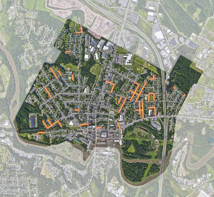
EN GAGEM E NT COMP LE T E D TO DATE

      Steering                          Community                           Public Meetings                            Immersion
     Committee                        Group Meetings                      Four public meetings with residents,   Initial week-long immersion by the
      Meetings                       Cultural & community groups such as:
                                                                           workers, and visitors who use the
                                                                                      parks daily.
                                                                                                                 planning team, and continued 3-5
                                                                                                                 day visits for subsequent meetings
                                             New American Lunch           (2 completed to date: 10/25/2019
Weekly meetings with community             Winooski Senior Center                 and 12/10/2019)
leadership in Parks, Planning, and       Coffee at the O’Brien Center
      Community Services                    Patriots Soccer League
                                          Winooski Historical Society
                                      Winooski Schools Cultural Liaisons
                                      Winooski Schools Administration
                                          Winooski School Students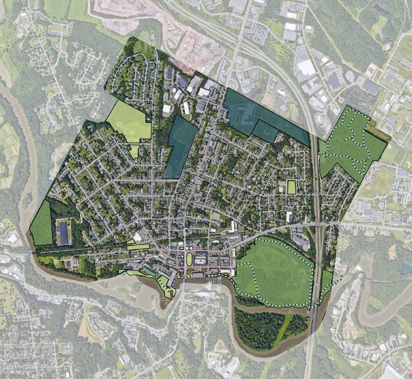
F U T U R E CO MMUNIT Y E N GAGE M E N T

                                             YOUR PARKS,
                                             YOUR WINOOSKI                                                                                    A     B

                                                            Do you have a
                                                              BIG IDEA
                                                            for this park?
                                                   E-mail info@omnes.studio and tell us!

                                              The City of Winooski is creating a Parks and Open Space Master Plan, and needs
                                                                                                                                             YES   NO
                                              YOUR help to define a vision for the future. The master plan will create equitable
                                              and connected public space, with the goal of having a park within a ten-minute
                                              walk of every resident.

                                                        THE WINOOSKI PARKS AND OPEN SPACE MASTER PLAN:
                                                                       A PLANNING COLLABORATION WITH

                                                                                  YOU
                                                                                      +
                                                                                          Omnes
                                                                                           Landscape Architecture, Planning, & Art
                                                                                           www.omnes.studio

Working Groups                         Park Signage                                                                                  Online Survey                  Public Meetings
   Stakeholder meetings with       Signs posted in park spaces to solicit                                                                                          Four public meetings with residents,
 community leaders and potential                feedback                                                                             Survey with initial schemes    workers, and visitors who use the
      partners, focused on:                                                                                                              (Jan 2020 launch)                     parks daily.
       Civic Engagement                                                                                                                                               January and February 2020
         Conservation
          Maintenance
             Health
Developers, Business Owners, and
      Downtown Winooski
WH AT WE HE A RD - MA IN TH E ME S

                     MULTI-SEASONAL
                      RECREATION                     A CONNECTED
                     (SWIMMING, SKATING, ETC.)      & DEFINED TRAIL
                                                       NETWORK

   MORE PLACES TO PLAY
       (INDOOR/OUTDOOR)
                                                             MORE PUBLIC
                                                              AMENITIES
                                                         (SIDEWALKS, SEATING, SIGNAGE/
                                                                 WAYFINDING)

                                  IMPROVED SPORTS &
                                 RECREATION AMENITIES
PU B L IC ENGAG E ME NT
WINOOSKI SENIOR CENTER
OCTOBER 23, 2019
What We Heard
1. Winooski parks are physically challenging for seniors to access and
navigate.
2. Park entrances are difficult-to-access and trails are poorly
maintained.
3. Off-leash dog walking is common in City parks, and is a further
deterrent to some seniors.
4. The Senior Center does not organize programming in parks
because access is too difficult, and park conditions are
unpredictable.
5. Trail sharing between bicyclists and senior pedestrians can
be strained; parks need design solutions to separate bike and
pedestrian trails, and/or greater signage/education about how to
use and share trails.
6. There is no easy-to-find comprehensive map/guide of all
Winooski’s trails and parks.
7. There are many parks in Winooski but they don’t feel like part of a
unified “parks system.”
Who We Talked To
1. Community Seniors - Longtime Residents and Recent Transplants
2. Winooski Senior Center Program + City StaffPU B L IC ENGAG E ME NT
NEW AMERICAN LUNCH @ WINOOSKI SENIOR CENTER
OCTOBER 25, 2019
What We Heard
1. New American seniors are largely unfamiliar with the city’s parks.
2. Parks and large open spaces do not feel safe to some.
3. Spending time in parks in leisure is not a typical activity or
culturally familiar experience for some - as one resident noted, “In
Bhutan, we worked. No time for parks.”
4. Winooski’s weather is also a barrier to park and open space use for
some New Americans originally from warmer climates.
5. There isn’t much about Winooski’s parks that seems specifically
intended to serve or represent its diverse communities.
Who We Talked To
1. New American Seniors
2. Longtime Resident Seniors
3. Program Coordinator and TranslatorPU B L IC ENGAG E ME NT
SITE VISIT: LANDRY PARK
OCTOBER 23 + 24, 2019
What We Heard
1. Landry is Winooski’s “best park” for families with children.
2. There should be more outdoor activity options for winter in
Winooski.
3. There is nowhere to ice skate in Winooski.
4. A dedicated sledding hill would be well-used; the hill works as is,
but people run into the fences at tennis courts.
5. Families visit parks they can walk to, but rarely those to which they
have to drive.
6. Lack of restrooms facilities at parks deters families with young
children from visiting.
7. There is no comprehensive map/guide of Winooski’s trails, and
it can be difficult to tell if a trail is truly a formal park trail, or an
informal/unsanctioned or private property path.
8. There is sometimes scheduling conflict between sports programs,
such as adult softball and youth soccer, over field use at Landry.
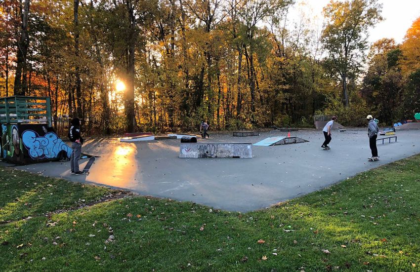
9. The skate park at Landry is “awesome” and some skaters prefer it
to Burlington’s A_Dog Park.
10. The City needs more public art and should turn the graffiti at
Casavant into a sanctioned space of some kind.
Who We Talked To
1. Parents and grandparents of elementary and middle grade children
2. UVM students
3. Vermont Patriots Integrative Soccer Academy organizersPU B L IC ENGAG E ME NT
FURTHER CONVERSATIONS WITH THE COMMUNITY
OCTOBER + DECEMBER 2019
More Places We’ve Talked
With the Community
1. O’Brien Community Center: 10/24 + 10/25
2. Richards Park: 10/25 + 12/8
3. Rotary Park: 10/23-26 + 12/8
4. The Haunted Mill at Champlain Mill: 10/25
5. Winooski Library: 10/25
6. Gilbrook: 10/25 + 12/8
7. Public MTG #1: Halloween in Winooski @VSAC: 10/26
Other Site Visits
1. The Riverwalk: 10/25 + 12/8
2. Memorial Park: 10/24
3. Casavant: 10/26
4. West Allen Park: 10/25
5. O’Brien Community Center Garden: 10/25
6. St. Francis Xavier Cemetery: 10/25PA RKS & OPE N SPAC E MASTE R PL AN GOALS
Consider expansion of the Neighborhood Development Area designation to the entire
                                                                                                                     City.

                              LAND USE
                            Goals / Objectives                                                                       Protect, preserve, develop and use Winooski's historic, cultural and architectural
                                                                                                                     resources to stimulate a more meaningful environment for its citizens residents and
                                                                                                                     the region; maintain the architectural and historical integrity of existing buildings or
                                                                                                                     features; and ensure the compatibility of new construction or usage to adjacent
                                                                                                                     properties.

Considering the limited land area in Winooski,                                                                       Review and improve the historic preservation
continue to infill and build upward in                                                                               section of the Unified Land Use Development
accordance with the land use regulations to                                                                          Regulations to ensure proper protection of these
ensure economic sustainability.                                                                                      resources.

Continue development and support for the                                                                             Maintain and improve the City’s parks and open
Downtown Core.                                                                                                       spaces for wildlife habitat and crossings, water
                                                                                                                     quality protection, flood attenuation, carbon
                                                                                                                     sequestration, and human enjoyment.

                                                                                                                     Promote vegetative landscaping in new
Transform the Gateway districts using both public and private sector investment to:                                  development projects and municipal improvement
a. Capitalize on public investment in existing infrastructure                                                        projects to manage storm water, protect water
b. Stabilize and strengthen mixed-use commercial areas and residential neighborhoods                                 quality and air quality, increase carbon
c. Create a pedestrian-friendly and multi-modal district                                                             sequestration and establish urban place making;
d. Promote, create, and expand housing options                                                                       and protect forest blocks, wildlife connectivity
e. Ensure a complementary relationship between the Corridors and the surrounding neighborhoods
f. Better utilize existing resources to redevelop under-utilized lots and create an improved pedestrian experience   resources and crossings, surface waters, riparian
                                                                                                                     areas and other significant habitats (e.g. wetlands)
                                                                                                                     from development and fragmentation along the
                                                                                                                     undeveloped parts of the Winooski River and the
Refine the 2016 Unified Land Use & Development Regulations to improve the                                            Gilbrook Natural Area.
implementation of the Form Based Code and this Master Plan, including parking
requirements, future land uses, stormwater management, and other refinements.                                        Maintain the flood hazard area to protect from
                                                                                                                     flooding.

Preserve the scale, character, and value of
established neighborhoods by ensuring that                                                                           Review the mapped River Corridor area, work with
new residential development is well integrated                                                                       the state to make sure it is accurate and develop
with existing development as called for in the                                                                       land use regulations to protect these areas in order
Unified Land Use & Development Regulations.                                                                          to continue receiving the best match for
                                                                                                                     emergency relief assistance funds.

                                                                                                                     It is not the intent of this plan to protect agricultural
When considering residential neighborhood                                                                            soils from development considering agricultural
redevelopment allow for neighborhood scale                                                                           operations (outside of community gardens) are not
retail and services within residential                                                                               feasible on small parcels isolated from more intact
neighborhoods.                                                                                                       open agricultural areas. Further, mitigation of these
                                                                                                                     soils through state development approval
                                                                                                                     processes does not seem appropriate in such an
                                                                                                                     urban environment.
Maintain and evolve the commercial and
industrial districts as needed to retain and
grow existing businesses, and enable start-
ups and tech businesses

Review zoning to maximize opportunities
for the recreational economy.
ECONOMIC VITALITY MUNICIPAL INFRASTRUCTURE
Goals / Objectives Goals / Objectives
For a more detailed list of actions, please see: The goals and actions in the following plans are hereby incorporated by reference into the Master Plan. Please
see these Plans for a more detailed list of goals and actions:
The Economic Development Plan for the City of Winooski by Camoin Associates Winooski Transportation Downtown Parking Plan by All-Hazards Mitigation Plan
Master Plan by VHB Desman Design Management
Winooski Main Street Revitalization Project by VHB Enhanced Energy Supplement
Foster business development retention and expansion by building on regional assets, local
resources, and existing business environment dynamics through promotion of available
resources and financing opportunities, advancing networking opportunities and Utilize technology/data collection to better manage city infrastructure. Preserve and
commitment of local resources. maintain the existing city infrastructure system, and utilize technology/data collection to
inform this work.
Diversify and enhance services available to existing
residents and business community to address the Increase opportunities for stormwater
needs identified in the Economic Development Plan treatment through low impact
and pursue additional planning initiatives as development (e.g. reduce impervious
resources allow. surfaces and stormwater disconnection)
and green stormwater infrastructure (e.g.
Maintain, manage, and reinvigorate the city’s built planter boxes, rain gardens and green
and natural environment through implementation roofs) practices.
of high priority multi-modal projects, coordination
of utility upgrades with private investment on the
Gateways (such as utility and streetscape Provide reliable and safe services, clean
improvements on Main Street), and work to utilize water, treated wastewater and
the recreation potential of publicly owned lands. stormwater management
Support initiatives that enhance residents’ quality of life, including aspects of housing,
health, accessibility and community spirit. See the Housing and Community chapters for
more detail.
Improve and maintain streets and sidewalks for safety and convenience for
all users at all times of the year. Every street in the City will have at least
one sidewalk starting with the priority segments identified in the
Transportation Master Plan.
Target economic development resources towards high-priority industries that demonstrate
regional and local employment opportunities such as tech-based companies, specialized
manufacturing or entertainment and hospitality offerings.
Pursue and support alternative energy generation, efficiency and weatherization programs,
and electrification of the transportation fleet with the community and in line with the State’s
Comprehensive Energy Plan goals.
Utilize Opportunity Zone designation to attract and support start-ups, tech industry and
commercial and real estate investment.
Maintain a healthy and diverse urban forest.
Determine the City's budgetary needs based on additional revenue that may be realized
by the end of the TIF period in 2025 and identify programs that may be supported by this
additional revenue.
Establish and implement a wayfinding plan to encourage those driving through to stay
and visit the City’s restaurants, bars, parks and cultural offerings.
Pursue an Arts/Cultural District as described in the Economic Development Plan.Winooski will partner with local healthcare
providers to support improved access to
healthcare services, while also supporting health
promotion and education initiatives that promote
SAFE, HEALTHY, CONNECTED PEOPLE improved well-being for Winooski residents (i.e.
"complete streets", smoke free zones), and
support for local health resources.
Goals / Objectives
Winooski residents (and their loved ones) who are
struggling with mental health issues, substance
use or abuse will have access to the
For more information, see:
comprehensive supports necessary to address
their use, and will be able to access those services
Police Department Winooski School District Winooski School District & City
Strategic Plan Continuous Improvement Plan of Winooski MOU with dignity. Our community will also focus on
substance use prevention efforts.
Maintain and establish safe and inviting walkable connections throughout the City and to Continue to retain and manage the O'Brien Community Center as a hub for various human
neighboring communities with sidewalks, crosswalks, greenways and streetscape and social service resources, while seeking to increase on site programming and make
amenities (wayfinding, street trees, sitting areas, lighting). improvements and developments that maximize use of the 32 Malletts Bay Ave property.
Focus on enhancing the Library facility to enable increased programming, public gathering
Maintain a vibrant, healthy urban space, expanded circulation materials (including non-literary resources), and opportunities
forest in all parts of the City. to learn. Improve promotion and way-finding to encourage more Winooski residents and
visitors to use the Public Library.
Maintain and improve the City’s parks,
natural areas and facilities for exercise and
recreation opportunities for all ages and to Conduct routine assessments of the community's programming interests and needs
achieve a goal of having all Winooski (including public feedback, analysis of changing demographics, and trends in recreation),
residents within an easily accessible 10 and use the results to develop a responsive and diverse slate of year-round program
minute walk of a high quality park or natural offerings including expansion of programs through public and private partnerships, and
area through development of a Parks and focus on increased water safety and aquatics programming (through or restoration of
Open Space Master Plan of current and Myers Pool or partnerships with other agencies).
future facilities (including wayfinding,
locations for dog owners, programs, etc.).
Implement the recommendations from the
branding study to improve tourism Ensure that Winooski residents have access to high-quality, affordable childcare options
opportunities in the City. for infant, toddler, pre-school aged and school-aged children.
All students will graduate from the Winooski School District (WSD) college and career ready
at a cost supported by a majority of the Winooski community. WSD students will lead Winooski Seniors (55+) will have access (including transportation services) to programs,
healthy, productive and successful lives and engage with their local and global community. resources, and places to gather that empower them for personal independence, healthy
aging, social connection, and life-long learning.
Winooski residents will have access to affordable, adequate food resources that allows them
to make healthy, culturally-responsive eating choices. Improve transportation services for all to enable independence, social connection, and
access to necessary services.Improve the City’s website and continue to
grow an online presence to tell the story of the
City and provide the residents with convenient
access to the resources they need. HOUSING
Support sustainable growth, density and
Goals / Objectives
creation of additional housing units.
Establish opportunities for City officials (elected,
appointed and staff) to spend time developing For more information, see:
and cultivating relationships with a diverse set of
our community.
2016 Winooski Housing Needs Assessment Winooski Housing Commission documents
Improve energy efficiency of new and existing
buildings.
Continue volunteer recruitment and management efforts, with hopes of maximizing the
City's strong human capital.
Encourage the development of affordable housing options for a broad range of income
levels.
Continue to find ways to make Winooski's Municipal Government open, accessible, Encourage
representative, and participatory (such as opportunities to serve on Commissions). Foster a mixlow impact development
of housing practices
types to serve the to infiltrate stormwater and to reduce the
volumeofofdifferent
needs stormwater runoff
family from new and existing development.
compositions,
household types and multi-generational
needs.
Ensure adequate staffing, training and
equipment needed for community policing, fire
protection and code enforcement to meet the
growing needs of the city. Promote quality housing that is safe,
healthy
Ensure and durable.
housing areas include healthy,
diverse trees.
Continue current mutual aid and partnership
agreements for other safety services like
rescue; and explore making Winooski
Dispatch a regional partner. Preserve and sustain the scale, character and settlement patterns of our neighborhoods.
Work with the Chittenden County Homeless
Alliance to advance their vision of safe,
decent, affordable, stable homes for every
person and family in Chittenden County.
Foster the development of neighborhood
identities.
Protect current residents from displacement.
Increase gender and racial diversity on Staff and Boards to more accurately match
the gender and racial make-up of Winooski residents.G U I D ING PRINCIP LE S
How do we de f ine s u c c e ss f o r
th i s imp or t ant planning e f f o r t ?
Safe, Healthy,
Connected
People
Foster relationships across
generations and cultures by
providing a safe and healthy
environment and providing
opportunities to connect and
engage with other residents of the
City.G U I D ING PRINCIP LE S
How do we de f ine s u c c e ss f o r
th i s imp or t ant planning e f f o r t ?
Safe, Healthy, A Walkable
Connected and Active City
People Establish public open space within
a 10-minute walk of every resident
Foster relationships across and worker in Winooski in order
generations and cultures by to promote health, equity, and
providing a safe and healthy community connection.
environment and providing
opportunities to connect and
engage with other residents of the
City.G U I D ING PRINCIP LE S
How do we de f ine s u c c e ss f o r
th i s imp or t ant planning e f f o r t ?
Safe, Healthy, A Walkable A Place of
Connected and Active City Heritage and
People Establish public open space within Diversity
a 10-minute walk of every resident
Foster relationships across and worker in Winooski in order Protect and celebrate Winooski’s
generations and cultures by to promote health, equity, and rich heritage and historic character.
providing a safe and healthy community connection. Continue the legacy of this diverse
environment and providing and inclusive place of opportunity
opportunities to connect and — today and for future generations.
engage with other residents of the
City.G U I D ING PRINCIP LE S
How do we de f ine s u c c e ss f o r
th i s imp or t ant planning e f f o r t ?
Safe, Healthy, A Walkable A Place of Networked
Connected and Active City Heritage and and Resilient
People Establish public open space within Diversity Ecologies
a 10-minute walk of every resident
Foster relationships across and worker in Winooski in order Protect and celebrate Winooski’s Establish resilient and
generations and cultures by to promote health, equity, and rich heritage and historic character. timelessly sustainable green
providing a safe and healthy community connection. Continue the legacy of this diverse infrastructure while also enhancing
environment and providing and inclusive place of opportunity and maintaining a network of
opportunities to connect and — today and for future generations. valuable ecological settings and
engage with other residents of the habitat.
City.IDE NTI T Y & H E RI TAGE
H E R I TAGE & L A NDS CA P E D E V E LOPME N T
H E R I TAGE & L A NDS CA P E D E V E LOPME N T

                   The riverine landscape of Winooski Falls, 1840s   Contemporary Winooski, VT
H E R I TAGE & L A NDS CA P E D E V E LOPME N T 3000 BC to the Early 1700s 1723-1725 1772-1773 1780s 1840-1860s The Abenaki people inhabited Chief Grey Lock led defense of his Ira Allen and Remember Baker arrive Ethan Allen established a shipyard, During the era of robust rail the Valley of Winooskie-Took for lands and engaged in conflicts with at the falls with a camp of men. Ira forges, and a furnace south of the construction, The Mills were thousands of years, relying upon the the English in 1723-1725, famously and Ethan Allen pool their resources Falls, and new roads focused on established along the banks of the landscape for food, medicine, and fending off Captain Benjamin Wright with brothers Heman and Zimri, as his riverfront development. He also Falls. Clearing the existing lands dyes. They utilized plants such as to Northfield in 1725. Eastern Abenaki well as Baker, to buy the Onion River established a dam at the falls, which for industrial use, the riparian zone maples, butternuts, black walnuts, groups made peace in 1725-1726, yet Valley. They acquired 45,000 acres was taken during a freshet in 1830 became fortified. oak, hazelnuts, staghorn sumac, Grey Lock refused to yield. in total when they registered their (but subsequently rebuilt). A ferry on blackberries, and raspberries. They charter. the Millpond area shuttled workers also cultivated corn, beans, squash, across the river. and tobacco for harvest. Note: Image from 1840s 1890s 1927 1961 1970-1974 2000s Density of downtown increased The great flood of 1927 inundated The interchange at I-89 for Winooski With funding from the U.S. Dept. of Development within the TIF zone and dramatically due to the success of the Winooski River floodplain. The is established, tying in with new Housing and Urban Development, improvements of Rotary Park and the Mills and connection to commerce flood destroyed much of downtown, roads for Route 15 (East Allen St.). Winooski experienced “urban Riverwalk brought transformative via Lake Champlain. At this time, as well as the railroad & pedestrian The reservoir at Gilbrook along I-89 renewal” of the downtown. This change to the downtown core; it also streetcars and rail became prevalent bridge connecting Winooski and was fortified with concrete walls and period followed establishment of the re-established a new relationship in the region, allowing connectivity Burlington. metal shoring. Today, trees and plants Model Cities Program of 1967 that with the Winooski River and the between Winooski and adjacent have grown to act as a buffer against improved civic infrastructure and gateway to the City. communities. the highway. parks. Source: • https://en.wikipedia.org/wiki/Gray_Lock • The Winooski, Rivers of America Books by Ralph Nading Hill, 1949 • http://academics.smcvt.edu/winooskimills/Abenaki/Abenakiframe.htm • https://www.ccrpcvt.org/wp-content/uploads/2017/06/ Winooski-Bridge-Project-ARA-Report.pdfhttps://en.wikipedia.org/wiki/Gray_Lock
D EM OGRAPHICS
PAR KS & O PE N S PACE

                         K EY
                                Ne ig h b o rh o o d & Ci vic Parks (32 acres)
                                Na t u ra l A re a s (132 acres)
                                Tra ils ( 3 .2 mil es)
                                Se mi- Pu b lic Open Spaces (50 acres)
PAR KS PER PE RS ON
*
* Includes areas zoned as
Industrial (Casavant Natural Area
and Memorial Park)C O MPAR ABLE CITIE S
WINOOSKI, VT
WINOOSKI, VT WOONSOCKET, RI
WOONSOCKET, RI BELLOWS FALLS,FALLS,
BELLOWS VT VT SPRINGFIELD, VT
SPRINGFIELD, VT
1”=10 00’
7.7 SQ. MI.7.7 SQ. MI. 1.4 SQ. MI.1.4 SQ. MI. 49.5 SQ. MI.
49.5 SQ. MI.
7,337
7,337
TOTAL POPULATION
TOTAL POPULATION
41,603
41,603
TOTAL POPULATION
TOTAL POPULATION
3,004
3,004
TOTAL POPULATION
TOTAL POPULATION
9,373
9,373
TOTAL POPULATION
TOTAL POPULATION
(2018, ACS FactFinder)
(2018, ACS FactFinder)
34 34 (2018, US Census
(2018,Quick Facts) Quick Facts)
US Census
102 102 (2018, ACS FactFinder)
(2018, ACS FactFinder)
x x (2018, ACS FactFinder)
(2018, ACS FactFinder)
18 18
PEOPLE/ACRE OF PARK OF PARK
PEOPLE/ACRE PEOPLE/ACRE OF PARK OF PARK
PEOPLE/ACRE PEOPLE/ACRE OF PARK OF PARK
PEOPLE/ACRE PEOPLE/ACRE OF PARK OF PARK
PEOPLE/ACRE
20% 20% 19% 19% x% x% 16% 16%
PARK PARK PARK PARK PARK PARK PARK PARK
26.2%
26.2% 24.4%
24.4% 25.7%
25.7% 17.4%
17.4%
BELOW POVERTY LINE
BELOW POVERTY LINE BELOW POVERTY LINE
BELOW POVERTY LINE BELOW POVERTY LINE
BELOW POVERTY LINE BELOW POVERTY LINE
BELOW POVERTY LINE
1.5 SQ. MI.1.5 SQ. MI. 7.7 SQ. MI.7.7 SQ. MI. 1.4 SQ. MI.1.4 SQ. MI. 49.5 SQ. MI.
49.5 SQ. MI.
213 ACRES OFACRES
213 PARK OF PARK 408 ACRES OFACRES
408 PARK OF PARK x ACRES OF PARK OF PARK
x ACRES 511 ACRES OFACRES
511 PARK OF PARK
80.8% WHITE80.8% WHITE 77.6% WHITE77.6% WHITE 94.3% WHITE94.3% WHITE 95.6% WHITE95.6% WHITE
4.5% BLACK4.5% BLACK 8.6% BLACK8.6% BLACK 2.2% BLACK2.2% BLACK 1.0% BLACK1.0% BLACK
11.6% ASIAN11.6% ASIAN 7.3% ASIAN7.3% ASIAN 0% ASIAN 0% ASIAN 0% ASIAN 0% ASIAN
2.8 HISPANIC
0.3% AMERICAN
2.8OR LATINOOR LATINO
HISPANIC
INDIAN/ALASKAN
0.3% AMERICAN INDIAN/ALASKAN 9 9 17.3% HISPANIC
0.7% AMERICAN
17.3%OR LATINOOR LATINO
HISPANIC
INDIAN/ALASKAN
0.7% AMERICAN INDIAN/ALASKAN X X 1.9% HISPANIC
0% AMERICAN
1.9%OR LATINOOR LATINO
HISPANIC
INDIAN/ALASKAN
0% AMERICAN INDIAN/ALASKAN x x 1.0% HISPANIC
0.4% AMERICAN
1.0%OR LATINOOR LATINO
HISPANIC
INDIAN/ALASKAN
0.4% AMERICAN INDIAN/ALASKAN 6 6
1.4% TWO OR MORE
1.4% TWORACES
OR MORE RACES # OF PARKS
# OF PARKS PARKS & REC STAFF
PARKS & REC STAFF PARKS & REC STAFF
PARKS & REC STAFF # OF PARKS
# OF PARKS
WINOOSKI, VT HUDSON, NY PORT JERVAIS, NY SPRINGFIELD, VT
WINOOSKI,
WINOOSKI,
VT VT HUDSON,
WOONSOCKET,
WOONSOCKET, RINY
RI HUDSON, NY BELLOWS PORT
BELLOWS
FALLS,JERVAIS,
PORT
FALLS, VT NY
VT JERVAIS, NY RENSSALEAER, NYSPRINGFIELD,
RENSSALEAER, NY VT VT
SPRINGFIELD,
7.7 SQ. MI.
7.7 SQ. 2.16
MI. SQ. MI.
2.16 SQ. MI. 1.4 SQ. MI.
1.4 SQ.2.5
MI.SQ. MI.2.5 SQ. MI. 49.5 SQ.49.5
3.5 SQ. MI.3.5 SQ. MI. MI. SQ. MI.
7,337
7,337
TOTAL POPULATION
TOTAL POPULATION
6,713
6,713
41,603
41,603
TOTAL
TOTALPOPULATION
TOTAL
TOTAL POPULATION
POPULATION
POPULATION
8,828
8,828
3,004
3,004
TOTAL
TOTALPOPULATION
TOTAL
TOTAL POPULATION
POPULATION
POPULATION
9,392
9,392
9,373
9,373
TOTAL
TOTALPOPULATION
TOTAL
TOTAL POPULATION
POPULATION
POPULATION
(2018, ACS(2018,
FactFinder)
ACS FactFinder)
34 34
(2018,US
(2018, ACS FactFinder)
(2018,
Census
(2018, US ACS
Quick FactFinder)
Census
Facts)
Quick Facts)
210
102 210
102
(2018, ACS
(2018, FactFinder)
(2018,
ACS(2018, ACS
ACSFactFinder)
FactFinder)FactFinder)
21 21
x OF PARK
x OF PARK
(2018, ACS
(2018, FactFinder)
(2018,
ACS(2018, ACS
ACSFactFinder)
FactFinder)FactFinder)
x 18
18 x
PEOPLE/ACRE
PEOPLE/ACRE
OF PARKOF PARK PEOPLE/ACRE OF PARK OF PARK
PEOPLE/ACRE
PEOPLE/ACRE
PEOPLE/ACRE
OF PARKOF PARK PEOPLE/ACRE
PEOPLE/ACRE
PEOPLE/ACRE
PEOPLE/ACRE
OF PARKOF PARK PEOPLE/ACRE
PEOPLE/ACREOF
OFPARK
PEOPLE/ACRE
PARKOF
PEOPLE/ACRE OF PARK
PARK
20% 20% 2.3%
19% 2.3%
19% 26%
x% 26%
x% x%
16% x%
16%
PARK PARK PARK
PARK PARK
PARK PARK
PARK PARK
PARK PARK
PARK PARK
PARK
26.2%
26.2% 19.2%
19.2%
24.4%
24.4% 18%25.7%
18%
25.7% 15.3%
15.3%
17.4%
17.4%
BELOW POVERTY
BELOW POVERTY
LINE LINE BELOW
BELOWPOVERTY
BELOW
POVERTYLINE
BELOW POVERTY
POVERTY
LINE LINE
LINE BELOW
BELOWPOVERTY
BELOW
POVERTYLINE
BELOW POVERTY
POVERTY
LINE LINE
LINE BELOW
BELOWPOVERTY
BELOW
POVERTYLINE
BELOW POVERTY
POVERTY
LINE LINE
LINE
1.5 SQ. MI.
1.5 SQ. MI. 2.16
7.7SQ.
SQ.MI.
2.16
MI. SQ. MI.
7.7 SQ. MI. 2.5
1.4SQ.
SQ.MI.
2.5
1.4 SQ.
MI. SQ. MI.
MI. 3.5 SQ.
49.5 MI.
SQ. 3.5
MI. SQ.
49.5 SQ.MI.
MI.
213 ACRES
213OFACRES
PARKOF PARK 31.93
408ACRES
ACRES
408OF
31.93OF PARK
ACRES
ACRES
PARKOFOFPARK
PARK 416x ACRES xOF
416 PARKOF
ACRES
ACRES OFPARK
PARK x511
ACRES OF
ACRES PARK
x ACRES
511 OF
ACRESOF
PARK OFPARK
PARK
80.8% WHITE80.8% WHITE 62.9%
77.6% WHITE
62.9%
77.6% WHITE
WHITE WHITE 75% WHITE
94.3% 75% WHITE
WHITE
94.3% WHITE 93.3%
95.6% WHITE
93.3%
95.6% WHITE
WHITE WHITE
4.5% BLACK 4.5% BLACK 22.2%
8.6%BLACK22.2%
BLACK8.6% BLACK 14.7%
2.2%BLACK14.7%
BLACK2.2% BLACK 5.6%
1.0%BLACK 5.6%
BLACK1.0% BLACK
BLACK
11.6% ASIAN
11.6% ASIAN 7.8%
7.3%ASIAN 7.8%
ASIAN7.3% ASIAN
ASIAN 1.2%
0%ASIAN
ASIAN1.2% ASIAN
0% ASIAN 7.9%
0%ASIAN
ASIAN7.9% ASIAN
0% ASIAN
2.8 HISPANIC
0.3% AMERICAN
2.8 HISPANIC
OR LATINO
0.3% AMERICAN
OR LATINO
INDIAN/ALASKAN
INDIAN/ALASKAN 9 9 0.1%
7.5% HISPANIC
17.3%
AMERICAN
0.7% 0.1%
AMERICAN
7.5%OR
HISPANIC
17.3% LATINO
HISPANIC
HISPANIC
OR LATINO
INDIAN/ALASKAN
0.7% AMERICAN
AMERICAN
OR
ORLATINO
LATINO
INDIAN/ALASKAN
INDIAN/ALASKAN
INDIAN/ALASKAN 9X 9
X 0.8%
8.5% HISPANIC
1.9%
0%AMERICAN
0.8%
AMERICAN
8.5%
HISPANIC
1.9%OR LATINO
HISPANIC
HISPANIC
OR
AMERICAN
0% AMERICAN
LATINO
INDIAN/ALASKAN
OR
OR LATINO
LATINO
INDIAN/ALASKAN
INDIAN/ALASKAN
INDIAN/ALASKAN 9x 9x 0.1%
5.9%
0.4%
HISPANIC
1.0% 5.9%
HISPANIC
AMERICAN
0.1%
1.0%OR LATINO
HISPANIC
HISPANIC
OR
0.4% AMERICAN
AMERICAN
LATINO
INDIAN/ALASKAN
AMERICAN
OR
OR LATINO
LATINO
INDIAN/ALASKAN
INDIAN/ALASKAN
INDIAN/ALASKAN x6 x6
1.4% TWO1.4%
OR MORE
TWO ORRACES
MORE RACES # OF PARKS
# OF PARKS # OF&PARKS
PARKS # STAFF
PARKS
REC OF
& PARKS
REC STAFF # OF&PARKS
PARKS # STAFF
PARKS
REC OF
& PARKS
REC STAFF PARKS
#& REC
OF STAFF
PARKS
PARKS& REC
# OF STAFF
PARKSFAC I LI TIES INV E NTORY
AVERAGE AGENCY WINOOSKI, VT
Outdoor Park and Recreation Facilities (2019 NRPA Performance Report) (213 acres )
1 1.7 Recs/Park
(2019, NRPA Agency Performance Review)
16.5
BASKETBALL FTE EMPLOYEES WITH
COURTOPERATIONS AND MAINTENANCE
PROGRAMMING
ERAGE AGENCY WINOOSKI, VT
M A I N TENAN CE & OP E RATI ON S
ADMINISTRATION
19 NRPA Performance Report) (213 acres )
CAPITAL DEVELOPMENT/OTHER 5%
1.7 Recs/Park
16.5
FTE EMPLOYEES WITHOPE N SPAC E & WAL KABI LI T Y
PAR KSER V WA LK A B ILIT Y BASE L I N E DATA
*
*Our math says 22% (213 acres of park out of 960 acres total).
Our calculations include areas that are used as parks, but zoned as
Industrial (Casavant Natural Area and Memorial Park).
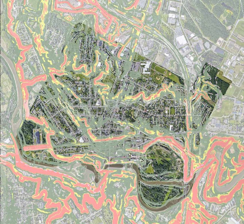
Source: Parkserv, Trust for Public LandPAR KSER V WA LK A B ILIT Y BASE L I N E DATA T h e Tru st f o r Pu b lic Land’s ParkServ map
su g g e st s lo ca t io n s in Winooski where
p a rks a re n e e d e d based on a 10-minute
wa lk f ro m re sid e n ces, while looking at
o t h e r f a ct o r s lik e income, age and race.
K EY
Pa rk Ne e d : Ve r y High
Pa rk Ne e d : H igh
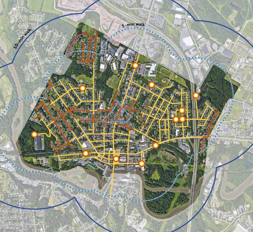
Source: Parkserv, Trust for Public LandWAL KABI LI T Y
10-min 5-min
walk radius walk radiusWAL KABI LI T Y
10-min 5-min
walk radius walk radius
K EY
5 - Min u t e Wa lk Zone
10 - Min u t e Wa lk Zone
A re a s o u t o f 10-Minute Walk Zone
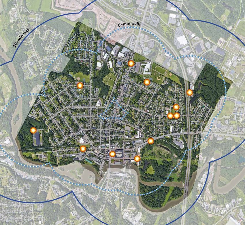
E n t ra n ce /Me a surement Start PointWAL KABI LI T Y
WALK
SCORE
26
WALK
SCORE
45
WALK
SCORE
55
WALK
SCORE
WALK
WALK
SCORE 24
SCORE 51
62
WALK
SCORE WALK
78 SCORE
62
10-min 5-min
walk radius walk radius
K EY
5 - Min u t e Wa lk Zone
10 - Min u t e Wa lk Zone
A re a s o u t o f 10-Minute Walk Zone
E n t ra n ce /Me a surement Start PointWAL KABI LI T Y
K EY
No sid e wa lk ( Per 03/18/19 Master
P la n )TO PO GRAPHY & S LOP E S
WALK
SCORE
26
WALK
SCORE
45
WALK
SCORE
55
WALK
SCORE
WALK
WALK
SCORE 24
SCORE 51
62
WALK
SCORE WALK
78 SCORE
62
K EY
Slo p e s A b ov e 2%
Slo p e s A b ov e 5%
Slo p e s A b ov e 10%EN H ANC ING WA LKA B ILIT Y
SIDEWALKS ON EVERY STREET SAFE LIGHTING SALTED & MAINTAINED WALKS
SAFE CROSSWALKS SIGNAGE & WAYFINDING SEPARATE LANES
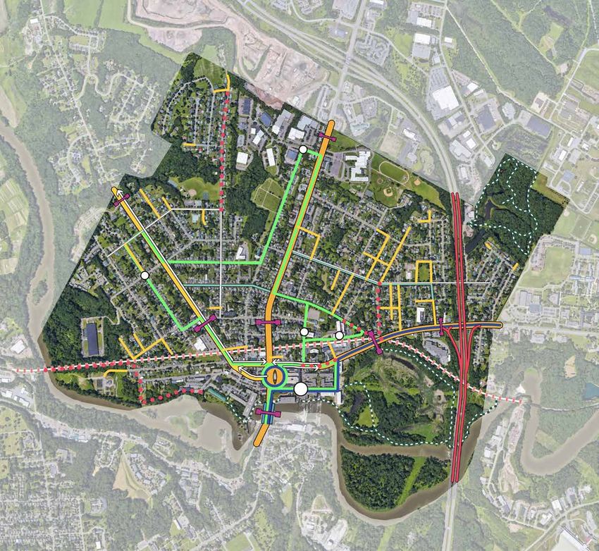
FOR PEDESTRIANS/BICYCLISTSUR BAN -SC AL E IN V E N TORY
C O NNEC TIV IT Y

                    K EY
                           Tra ils
                           Bik e L a n e s
                           Bik e Ro u t e Signage
                           ( Pe r Tra n sp o rt ation Master Plan)
                           In t e r st a t e
                           Prin cip a l A rt e r ial
                           Min o r A rt e ria l
                           Ma jo r Co lle ct or
                           Ra il Co rrid o r
                           Brid g e s
                           Sig n if ica n t Gateways & Threholds
                           Bu s Ro u t e s
                             Gre e n L in e
                             Blu e L in e
                           Bu s St o p
                           No Sid e wa lk ( Per 03/18/19 Master Plan)
                           Re co mme n d e d Pedestrian Network
                           E n h a n ce me n t s (Per Transportation
                           Ma st e r P la n )
L AND U SE
K EY
Ga t e wa y s
D o w n t o w n Co re
Re sid e n t ia l - A
Re sid e n t ia l - B
Re sid e n t ia l - C
Co mme rcia l - 1
Co mme rcia l - 2
In d u st ria l
Pu b licD ESTINATIO NS
D EST INATIONS + ‘MAG N E TS ’ 1. Heritage Winooski Mill
Museum
1. Winooski United
Methodist Church
2. Monkey House 2. Faith Baptist Church
3. St. Stephen Church
4. Valley Baptist
1. O’Brien Community Fellowship
Center 5. St. Francis Xavier
2. Winooski Senior Center 6. Grace United Church
3. Winooski Family Center
4. Somali Bantu Community
Association 1. O’Brien Center
3 3
5. Islamic Community Greenhouse
2 Center of Vermont 2. O’Brien Center
2
Community Garden
3. Senior Center
1. Winooski Memorial Community Garden
Library 4. West Street Community
5
2. Elementary School Garden
6
3. High School 5. Landry Park
4
4. St. Francis Xavier School Community Garden
5
4
31
1. City Hall/Police Station
4
2. Fire Station
3. Post Office
3
2 2
5
4 2
3
1. Winooski Family Center
1 1 2. Elementary School
1
2
3. UVM Medical Day Care
1
1 3
2 K EY
9+ Re t a il
1
25+ Fo o d
2 E n t e rt a in me n t
5 Co mmu n it y Center
4 In st it u t io n a l
3 Pu b lic Bu ild ings
3 Ch ild Ca re
6 Ch u rch e s
5 Co mmu n it y GardensSO C IAL SPACE S
K EY
So cia l Sp a ce s
So lit a ry /Re sp ite SpacesR E SI L IENC Y & FLOODING
K EY
F lo o d Ma p Bo undary
Re g u la t o ry F loodway
.2 % A n n u a l Chance Flood Hazard
Ju risd ict io n a l Boundary
Source: Info from FEMA Flood Map Service CenterECO LO GI CA L HA BITAT
K EY
We t la n d s
Me a d o w la n d s
Fo re st e d Tre e Cover
Fre sh wa t e r re tention
Rip a ria n zo n e
Op e n L a w n s ( little ecological value)
H a b it a t /Wild life BlocksPA RKS I N V E N TORY
FAC I LI TIES INV E NTORY

                            K EY
                                   Le isu re
                                   Sp o rt s
                                   A me n it ie s
                                   Co mmu n it y Center s
                                   Co mmu n it y Gardens
FAC I LI TIES INV E NTORY
Rated the #1 most used park Rated the least used park by
by the community* the community*
Landry Park / West Allen Park /
Facilities Source Meyers Pool Community Center Winooski Falls Park Winooski River Walk Rotary Park Richards Park Casavant Memorial Gilbrook
Facility Type Park Type: Park Park Park Plaza & Boardwalk Plaza Park Natural Area Natural Area Natural Area
Spatial Character: Social Social Social Social Social Social Solitary Solitary Solitary
SPORT
Basketball courts 86.1 Sport NRPA no yes no no no no no no no
Tennis courts (outdoor only) 79.7 Sport NRPA yes no no no no no no no no
Diamond fields: baseball - youth 77.9 Sport NRPA yes* no no no no no no no no
Diamond fields: softball fields - adult 66.5 Sport NRPA yes no no no no no no no no
Rectangular fields: multi-purpose 66.1 Sport NRPA yes no no no no yes no no no
Diamond fields: softball fields – youth 60.9 Sport NRPA yes no no no no no no no no
Multiuse courts - basketball, volleyball 42.0 Sport NRPA no* yes no no no no no no no
Skate park 26.2 Sport NRPA yes no no no no no no no no
LEISURE
Playgrounds 94.4% Leisure NRPA yes yes no no no no no no no
Dog park 59.3 Leisure NRPA no yes no no no no no no no
Swimming pools (outdoor only) 52.3 Leisure NRPA yes no no no no no no no no
Community gardens 46.3 Leisure NRPA yes yes no no no no no no no
Sledding Leisure yes no no no no no no no no
Trails Leisure yes no yes yes no no yes yes yes
AMENITIES
Restrooms Amenities yes yes* no no no no no no no
Benches/Seating Amenities no no yes yes yes no yes no yes
Picnic Tables Amenities yes no no no no yes no no no
Kiosk Amenities no no no no no no yes yes yes
Shade structure (gazebo, pavilion, etc) Amenities no no no no no yes no no no
ADA Accessible Amenities no no yes? yes yes no no no no
Lighting Amenities yes* no yes? yes? yes no no no no
Gathering space Amenities yes yes yes? yes yes yes no no no
Overlooks Amenities no no yes yes yes no yes? yes yes?
TOTAL YES 15 7 6 6 5 4 4 3 4
*with exceptions
*From October 2016 Community Engagement Data
KEY
Le isur e
S port s
A me ni tiesS I T E A N A LYS I S
Informal paths for mountain biking
L A N D RY PA R K & MY E R S P O O L
Sledding Hill
Clearing great for
dogs & open play & overlook Size:
• 17.97 acres + ~.25 acres Myers Pool
Path not ADA
accessible Site Elements & Amenities:
• Open Lawn
Soccer use conflicts
with softball • Sledding Hill
Open field -
flexible use • Softball Field
• Tennis Courts
• Volleyball Courts
Skate park well liked, Drainage swale • Skate Park
but low on amenities impinges on soccer use • Playground
Drainage issues Fence blocks sledding
& not well maintained • Open Lawn (used as soccer field)
Opportunity for
expanded use (pickleball,
• Parking Lots
volleyball, etc.) • Swimming Pool
Former restrooms and
storage space
• Clubhouse & Locker Rooms
• Community Gardens
• ADA access? Yes, but only along central path-
way
*
Well-utilized play area. Volleyball court
Not ADA accessible & underutilized & not
age separated well-maintained Programming:
• Sports: Softball, Soccer, Tennis, Volleyball
• Play
• Skateboarding
Parking & entry not intuitive & well-defined.
Parking demand will increase when pool opens
*
2020 Opening for new pool K EY
A sse t /Op p o rt unity
Ne e d /Ch a lle n ge
*
Opportunity for
expanded gardens T h re sh o ld /e n t ry
Community garden plots SCALE: NTSS I T E AWN A LYS I S
Community gardens
& greenhouse
E ST A L L E N PA R K
Size:
• 1.3 acres
Site Elements & Amenities:
• Open Lawn
• Sledding Hill (?)
Basketball court feels • Dog Park
remote. No seating or shade • Swingset
• Basketball Courts
• Basketball Court (O’Brien Community Center)
• Garden Plots (O’Brien Community Center)
• Green House (O’Brien Community Center)
Programming:
Community gardens • Sports: Softball, Soccer, Tennis, Volleyball
• Play
Steep hill
• Skateboarding
Linear dog run
good for catch Dog park has no shade,
Basketball court - has
some shade, but no seating seating, or play elements.
Swingset
* Park thresholds
not well defined
No seating around
play areas
No sidewalk on park edge
K EY
A sse t /Op p o rt unity
Ne e d /Ch a lle n ge
*
T h re sh o ld /e n t ry
SCALE: NTSSITE AN A LYS I S
R I C H A R D S PA R K
Diverse and unique tree
Size:
No sidewalks on species throughout park • 1.52 acres
site perimeter
Site Elements & Amenities:
• Open Lawn
Sidewalk only on one side - not
accessible & does not promote walkability • Gazebo
• Picnic Table Seating (2)
• ADA access? No
Programming:
• Flexible Lawn
Mature trees - • Dog Walking
great for climbing!
• Football
Flexible open lawn -
multiple programming
possibilities
No place for storage
of sports equipment
Gazebo overlook onto site
* ADA-designed tables, but not
within ADA accessible area
* Proximity to Gilbrook
K EY
A sse t /Op p o rt unity
Ne e d /Ch a lle n ge
*
T h re sh o ld /e n t ry
SCALE: NTSConfusing crossing
that does not align
with desire lines
S I T E A N RAOTA
LYS I S
RY PA R K
Opportunity for better connection
to surrounding retail?
Size:
Outdoor dining in • 0.9 acres
warm months
*
Site Elements & Amenities:
• Overlook plaza
Traffic prevents social • Open Lawn
use of park perimeter • Fountain
• Flags
• Year-round Christmas tree
• Seating
• ADA access? Yes
Fountain is great civic feature &
drowns out noise of traffic.
8-9’ site wall block view Programming:
of retail & restaurants • People-watching
• Festivals: Winooski Wednesdays and Hallow-
een in Winooski
Raised plaza in center prevents ADA
access & opportunity for programming
Crossing feels unsafe *
Opportunity for signage/art at
K EY
A sse t /Op p o rt unity
threshold of the City.
Ne e d /Ch a lle n ge
*
T h re sh o ld /e n t ry
SCALE: NTSNo ADA access to Mill Path
ST HIE TR IEV E RAWANL KA LYS I S
*
Potential programming or development
Overlook &
views of Falls
, FA L L S PA R K ,
A N D M I L L PAT H
** Great mural. Lighting &
clearance could be improved
* *
Great overlook / could
use more seating
Size:
• .6 miles
Site Elements & Amenities:
• Linear boardwalk and overlooks
for better connectivity • Seating areas
*
• Picnic tables
• Access to downtown core & attractions
• Open Sloped Lawn
Bridge not safe for • Swing
pedestrians & bicyclists
• ADA access? Yes, only along eastern River-
walk pathways
Programming:
• Boardwalk: Walking, Running, Biking
Access to rocks &
view of lower falls • Fishing
R I V E R WA L K • Birding & wildlife watching
• People-watching & picnicking
Entry not intuitive
& welcoming
*
Serene area for
recreation - could
have improved seating
& programming
K EY
A sse t /Op p o rt unity
Ne e d /Ch a lle n ge
*
T h re sh o ld /e n t ry
SCALE: NTS
FA L L S PA R K & M I L L PAT HS I TG EI L B RAO ONK NAATLYS I S
Informal entry & path to
Sunny Hollows in Colchester
*
URE AREA
Dashed line roughly indicates
industrially zoned area of park Size:
• 27.22 acres
Site Elements & Amenities:
• Trails
• Fresh Water Reservoirs
Creek & reservoir - potential • Porta-potties
educational opportunity • ADA access? No
Programming:
• Trails: Walking, Running
• Dirt Biking
Bridge over creek • Fishing (& annual fishing derby)
• Birding & wildlife watching
• Cross-country skiing
Pine overlook
& picnic area
* Some invasive
plant species along
reservoir
Fishing & wildlife viewing
Potential
additional parking?
Very little parking
& not well-defined
K EY
A sse t /Op p o rt unity
* *
Pathway & reservoir
bank erosion - muddy Ne e d /Ch a lle n ge
*
& not ADA accessible
T h re sh o ld /e n t ry
Trailhead & connection SCALE: NTS
to St. Michael’sPotential connection to Colchester trails?
Steep connection to trail
& no formal parking
SITE AN A LYS I S
M E M O R I A L PA R K
*
Size:
• 10.82 acres
Site Elements & Amenities:
• Trails
• River access points (informal)
• Parking
• ADA access? No
Programming:
• Trails: Walking, Running
Archaeological heritage should • Dirt Biking
be evident with signage/ No access point for affordable
interpretive wayfinding housing. Steep topography.
• Fishing
• Birding & wildlife watching
Potential programming use @ clearing?
Potential kayak/canoe launch
& connection to island?
Attractive overlooks
that have river access
Steep entrance not pedestrian
friendly or ADA-accessible
Views of bridge and
Intervale across river
Potential kayak/canoe launch?
*
K EY
Conflicting industrial use A sse t /Op p o rt unity
for CBD facility
Ne e d /Ch a lle n ge
*
Rail & wastewater treatment prevent
continuous greenway to Mill Path/Riverwalk T h re sh o ld /e n t ry
SCALE: NTS
Pedestrian/rail conflict - potential connection w. new bridge?S ICTASEAVAANN A LYS I S
T N AT U R A L A R E A
No ADA accessible
entries/trails
Size:
*
• 104.48 acres
Site Elements & Amenities:
• Trails
• River access points (informal)
• Open Lawn
• Wetlands
*
Acts as buffer between • Access to parking
I-89 and downtown
Diversity of wetland ecologies: • Informal Graffiti Art under I-89
seeps, vernal pools, wet meadow...
• Power line corridor
• ADA access? No
Multiple access points
along dense urban core
Invasive plants in Programming:
wetland marsh/meadow • Trails: Walking, Running
Stormwater asset
• Fishing
*
• Birding & wildlife watching
Topography creates
• Ultimate frisbee
muddy condition • Picnicking
Open field potential • Informal sports fields
for programming
Informal connection
to Gorge
Viewsheds of the Falls
Occasional overlooks opportunity
for seating, art, or interpretation
Power easement Informal art under I-89
passes through site
Riparian habitat value with
little/no human contact, as well
as opportunity for enhanced
water quality protection
K EY
A sse t /Op p o rt unity
Ne e d /Ch a lle n ge
*
T h re sh o ld /e n t ry
SCALE: NTSNE E D S ASSE SSM E N T
NEED S ASSESSME NT

           Physical
        Interventions
1. Define trails & pathways (ADA access,
     signage/wayfinding, interpretation,
     connection to trails)
2.   Connections to/from parks and
     open spaces (sidewalk gaps, slopes,
     establishing thresholds)
3.   Define & establish new recreational
     amenities (basketball, softball, soccer
     fields, cricket, pickleball, etc.)
4.   Water elements (fountains, swimming,
     fishing, etc.)
5.   Establish new play spaces (whether
     indoor or outdoors)
NEED S ASSESSME NT
Physical Programming
Interventions
1. Define trails & pathways (ADA access, 1. Year-round recreation (Ice skating, winter
signage/wayfinding, interpretation, huts & festivals, indoor recreation, etc.)
connection to trails) 2. Increased programming within parks to
2. Connections to/from parks and establish destinations (within & beyond
open spaces (sidewalk gaps, slopes, Winooski)
establishing thresholds) 3. Revenue-positive programming that
3. Define & establish new recreational sustains & helps grow future programs.
amenities (basketball, softball, soccer
fields, cricket, pickleball, etc.)
4. Water elements (fountains, swimming,
fishing, etc.)
5. Establish new play spaces (whether
indoor or outdoors)NEED S ASSESSME NT
Physical Programming Maintenance &
Interventions Operations
1. Define trails & pathways (ADA access, 1. Year-round recreation (Ice skating, winter 1. Park Stewards/ Adopt-a-Park program for
signage/wayfinding, interpretation, huts & festivals, indoor recreation, etc.) volunteerism (both in planning and future
connection to trails) 2. Increased programming within parks to park implementation)
2. Connections to/from parks and establish destinations (within & beyond 2. Staffing to expand program offerings
open spaces (sidewalk gaps, slopes, Winooski) 3. Enhanced maintenance regimens
establishing thresholds) 3. Revenue-positive programming that 4. Partnerships for conservation, restoration,
3. Define & establish new recreational sustains & helps grow future programs. and maintenance of natural lands.
amenities (basketball, softball, soccer
fields, cricket, pickleball, etc.)
4. Water elements (fountains, swimming,
fishing, etc.)
5. Establish new play spaces (whether
indoor or outdoors)NEED S ASSESSME NT
Physical Programming Maintenance & Marketing
Interventions Operations
1. Define trails & pathways (ADA access, 1. Year-round recreation (Ice skating, winter 1. Park Stewards/ Adopt-a-Park program for 1. A comprehensive trails map
signage/wayfinding, interpretation, huts & festivals, indoor recreation, etc.) volunteerism (both in planning and future 2. Promotion of lesser-known natural areas
connection to trails) 2. Increased programming within parks to park implementation) (Casavant & Memorial Park)
2. Connections to/from parks and establish destinations (within & beyond 2. Staffing to expand program offerings 3. Integration of art & culture through
open spaces (sidewalk gaps, slopes, Winooski) 3. Enhanced maintenance regimens programming and physical interventions,
establishing thresholds) 3. Revenue-positive programming that 4. Partnerships for conservation, restoration, creating enticing experiences
3. Define & establish new recreational sustains & helps grow future programs. and maintenance of natural lands. 4. Alternative funding sources
amenities (basketball, softball, soccer
fields, cricket, pickleball, etc.)
4. Water elements (fountains, swimming,
fishing, etc.)
5. Establish new play spaces (whether
indoor or outdoors)N E X T STE PS
PL ANNING P ROCE SS

         Inventory &                    Visioning                  Final Report
           Analysis
       OCTOBER TO NOVEMBER 2019    DECEMBER TO JANUARY 2019       FEBRUARY TO MARCH 2019

       COMMUNITY ENGAGEMENT THROUGHOUT THE PLANNING PROCESS

                 PUBLIC              PUBLIC          PUBLIC               PUBLIC
              MEETING NO. 1       MEETING NO. 2   MEETING NO. 3        MEETING NO. 4
               10/2019             12/2019          1/2020               2/2020
F U T U R E CO MMUNIT Y E N GAGE M E N T
NE X T MEE TING
JAN . 14 , 2 0 20
A B
YES NO
Safe, Healthy, Connected People
Commission Meeting 6:30 PM
Master Plan Online Survey
City Hall, Council Chambers Concept Review LaunchL A N D RY PA R K & MY E R S P O O L WINOOSKI, DID WE HEAR YOU?
Below are observations from the greater Winooski Community that
Winooski, did we
Informal paths for mountain biking were collected since our first public meeting on 10/25/2019.
hear you?
Clearing great for
dogs & open play
Sledding Hill
& overlook
This map shows observations from both Omnes and the
greater Winooski Community that was collected since
Use a postcard to tell us your ideas!
our first public meeting. Let us know what you think, and
Path not ADA
accessible if you have ideas to add!
Soccer use conflicts
with softball Open field - Use your park postcard to tell us your ideas for this park!
Want to tell us more? Send an email to info@omnes.studio
flexible use
r
you s!
Skate park well liked, Drainage swale
W H AT I S A L R E A DY G R E AT A B O U T W I N O O S K I ’S PA R KS A N D O P E N S S PAC E S ?
a
impinges on soccer use
ide
but low on amenities Fence blocks sledding
& not well maintained Drainage issues
Opportunity for K
expanded use (pickleball, PA R L
D RY P O O
volleyball, etc.) LAN ERS
Former restrooms and M Y
storage space & CASAVANT NATURAL
AREA: STREET ART
WINOOSKI
RIVER WALK
*
Well-utilized play area. Volleyball court
Not ADA accessible & underutilized & not CASAVANT NATURAL
age separated well-maintained AREA: BEAUTIFUL
VIEWS
Size:
• 17.97 acres + ~.25 acres Myers Pool
Site Elements & Amenities:
• Open Lawn
Parking & entry not intuitive & well-defined.
Parking demand will increase when pool opens • Sledding Hill W H AT C O U L D B E G R E AT A B O U T W I N O O S K I ’S PA R KS A N D O P E N S S PAC E S ?
*
• Softball Field
• Tennis Courts
• Volleyball Courts
GILBROOK NATURE
• Skate Park AREA: MOUNTAIN BIKE ROTARY PARK
• Playground WEST ALLEN PARK:
TRAILS (SOUTH END):
INDOOR
KID STUFF
• Open Lawn (used as soccer field) BASKETBALL COURT
• Parking Lots RICHARDS PARK: CASAVANT NATURAL
• Swimming Pool PLAYGROUND! AREA: WIDER TRAILS
ROTARY PARK AND BETTER LIGHTING
• Clubhouse & Locker Rooms LANDRY PARK: (SOUTH END):
BETTER TRAILS, PLAYGROUND
2020 Opening for new pool • Community Gardens MOUNTAIN BIKE TRAILS
• ADA access? Yes, but only along central path-
KEY way
As s e t/Op p o rt u n it y
Opportunity for Programming:
N eed /C h a lle n g e expanded gardens • Sports: Softball, Soccer, Tennis, Volleyball
*
Community garden plots
• Play
Thres h o ld /e n t r y
• Skateboarding
SCALE: NTS
T H ES E ARE T H E EL EM EN TS O F MY P ERF EC T PARK (1 ). . . I W IS H T H E PARK N EAREST TO MY H O U S E/W OR K H AD MOR E ...
These are the elements of my perfect park...(1) I wish the park nearest to my house/work had more...
Fire Pits Overhead Elements Trees & gardens
pop quiz!
5.9% 7.8%
Sculpture #2 Trails & connections to
20.0%
14.3%
Water Elements
#1 16.5%
7.2%
Seating
#15
Open Lawns 2.9%
5.0%
Shady Groves
R
6.3%
PE N
Lighting Defined Trails
#2 Play space
5.0% 12.4%
#1
E Art Installations Festivals & markets 21.0%
OT IO
4.1% 18.1%
Wayfinding Ecological Habitat
1 VUEST
2.0% 9.3%
#15 Parklets
2.2%
Gallery/Murals
6.1%
#15 Signage & wayfinding
2.9%
Open lawn
4.8%
Q
Signage/Art Shade Structures Lighting Shade
7.6% 2.6%
#14 5.7% 10.5%
Do you plan on using the new Does this park need a new T H ES E ARE T H E EL EM EN TS O F MY P ERF EC T PARK (2 ). . . MY FAV O RIT E O P EN S PAC E IN W INOOS KI IS ...
What kind of field/court is most These are the elements of my perfect park...(2) My favorite open space in Winooski is...
Myers Pool AND Landry Park in bathroom or play structure Markets & Festivals Sports
#15 Public School Sports
needed here? 5.0% 9.9% 1.3% Landry Park &
#2
the same outing? more?
Dog Park Eating & Drinking Gilbrook Nature Area
21.1%
3.6% 4.3% 13.2%
Hiking/Biking Trails
5.6%
Gardening Casavant Natural Area
#15
Yes No Soccer Bathroom Play
2.3% 10.5%
Games
5.6% West Allen Park &
Performances
10.5%
3.6% Swimming
Structure Sledding & Tubing 30.1% #1
Richards Park
6.0%
#14
Softball #2 Ice Skating
2.6%
10.3%
Playing
7.6%
Watching Movies
3.3%
#14 #1 Winooski Riverwalk
40.8%
Volleyball
Cricket
Pickleball
TennisTHE CITY OF WINOOSKI
PARKS & OPEN SPACE MASTER PLAN
Public Session No. 2
December 10, 2019
Omnes
Landscape Architecture, Planning, & Art
www.omnes.studioYou can also read