UNIVERSITY OF FLORIDA CAMPUS MASTER PLAN, YEAR 2020 TRANSIT SYSTEM ANALYSIS - 2010-2020: UNIVERSITY OF FLORIDA
←
→
Page content transcription
If your browser does not render page correctly, please read the page content below
UNIVERSITY OF FLORIDA CAMPUS MASTER PLAN,
                 2010-2020:
    YEAR 2020 TRANSIT SYSTEM ANALYSIS

                   Prepared for:
             UNIVERSITY OF FLORIDA

                   Prepared by:

                  March 2011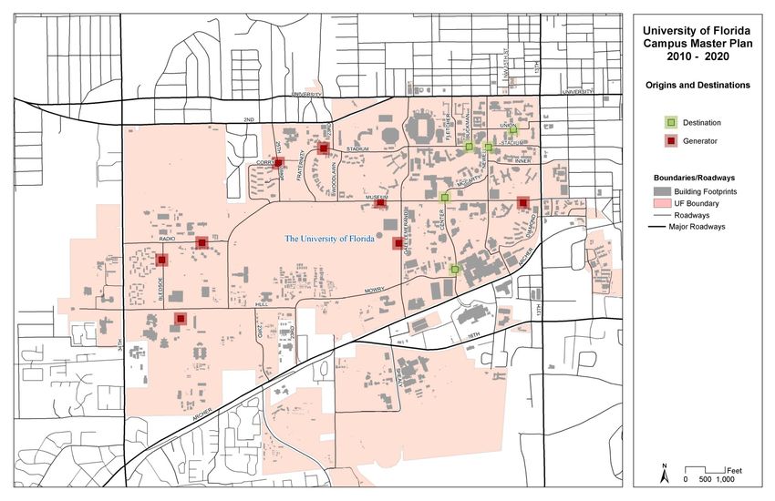
UF Campus Master Plan, 2010-2020,
                                                                                                               Year 2020 UF Transit System Analysis

                                                      TABLE OF CONTENTS

INTRODUCTION .............................................................................................................. 1
REVIEW OF PEER UNIVERSITIES ...................................................................................... 1
BUS ROUTE CLARITY & BRANDING................................................................................ 5
     Objective.......................................................................................................................................5
     Methodology ................................................................................................................................5
     comparative Analysis ..................................................................................................................5
     Recommendations ..................................................................................................................... 15
FACULTY CAB SERVICE................................................................................................. 22
     Objective.................................................................................................................................... 22
     Comparison Research............................................................................................................... 22
     Analysis Methodology ............................................................................................................. 22
     Results ......................................................................................................................................... 24
     Recommendations ..................................................................................................................... 24
DIRECTNESS TO DESTINATIONS ................................................................................... 25
     Objective.................................................................................................................................... 25
     Methodology ............................................................................................................................. 25
     Analysis....................................................................................................................................... 29
     Results ......................................................................................................................................... 36
     Recommendations ..................................................................................................................... 36
INTERFACE OF CITY AND CAMPUS BUSES (SUPPLY VS. DEMAND) ............................ 37
     Objective.................................................................................................................................... 37
     Methodology ............................................................................................................................. 37
     Implications of Strategy Implementation .............................................................................. 38
     Analysis and Results By Route ................................................................................................ 39
     Recommendations ..................................................................................................................... 43
PARK AND RIDE ANALYSIS .......................................................................................... 46
     Objective.................................................................................................................................... 46
     Methodology ............................................................................................................................. 46
     Results ......................................................................................................................................... 48

                                                                                                                                                        i
UF Campus Master Plan, 2010-2020,
                                                                                                           Year 2020 UF Transit System Analysis

      Recommendations ..................................................................................................................... 61
SUMMARY OF RECOMMENDATIONS .......................................................................... 62
      Bus Route Clarity and Branding ............................................................................................. 62
      Faculty Cab Service ................................................................................................................. 62
      Directness to Destinations ........................................................................................................ 63
      Interface of Campus Routes and City Routes....................................................................... 63
      Park and Ride Lots ................................................................................................................... 64

                                                            LIST OF MAPS

Map 1: Route Maps of Peer Universities – University of Florida: Regional Transit System
   City Routes ................................................................................................................................ 16
Map 2 Route Maps of Peer Universities – Florida State University: StarMetro ................... 17
Map 3: Route Maps of Peer Universities – University of Illinois at Urbana Champaign:
   Champaign - Urbana Mass Transit District .......................................................................... 18
Map 4: Route Maps of Peer Universities – University of Michigan: The Ride ....................... 19
Map 5: Route Maps of Peer Universities – University of North Carolina at Chapel Hill:
   Chapel Hill Transit ................................................................................................................... 20
Map 6: Route Maps of Peer Universities – University of Virginia: University Transit System21
Map 7: Top 26 Most Popular Campus Cab Pick-up and Drop-off Locations ....................... 23
Map 8: Origins and Destinations ................................................................................................... 28
Map 9: Identifying Park and Ride Lot Capture Area using Model Nodes for Travel Time 49
Map 10: Generalized Capture Area for Park and Ride Lot (Newberry Road and Ft.
   Clarke Blvd.) ............................................................................................................................. 50
Map 11: Generalized Capture Areas for All Potential Park and Ride Lots ......................... 50
Map 12: Potential Park and Ride Lot Locations and Accessibility Analysis........................... 55
Map 13: Year 2035 LTRP Transit Needs Plan............................................................................ 57

                                                         LIST OF FIGURES

Figure 1: Bus Stop Lookup Screenshot .......................................................................................... 10

                                                                                                                                                ii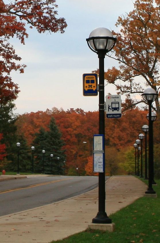
UF Campus Master Plan, 2010-2020,
                                                                                                       Year 2020 UF Transit System Analysis

                                                        LIST OF TABLES

Table 1: University of Florida Peer Universities Comparison ......................................................3
Table 2: Campus Cab Locations Not Directly Served by Campus Bus Routes ...................... 24
Table 3: RTS Campus Bus Routes Serving each Destination and Generator ......................... 27
Table 4: Shortest Driving Distance to Destinations ..................................................................... 30
Table 5: Bus Travel Distance to Destinations ............................................................................... 31
Table 6: Difference between Bus Travel Distance and Shortest Road Distance ................... 34
Table 7: Difference in Travel Time between Driving and Taking the Bus .............................. 35
Table 8: Route Recommendations to Decrease On-Campus Bus Traffic ................................ 44
Table 9: Population and Employment in Park and Ride Lot Capture Areas ......................... 52
Table 10: UF Employee and Student Residences (in TAZs) within Three Miles of Potential
    Park and Ride Lots ................................................................................................................... 54
Table 11: Transit Service Characteristics at Potential Park and Ride Lots ............................ 58
Table 12: Planned Regional Transit System Service Span and Frequencies by Service Type59
Table 13: Congestion Levels on Potential Park and Ride Lot Corridors................................. 60
Table 14: Travel Time Comparison for Auto vs. Transit Trips .................................................. 61

                                                                                                                                          iii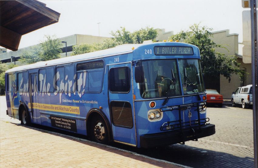
UF Campus Master Plan, 2010-2020,
                                                                         Year 2020 UF Transit System Analysis

INTRODUCTION
The Transit System Analysis provides an overall of future transit system needs for the University of
Florida. A major component of the Campus Master Plan Transportation Element, the transit
system and related programs provides a foundation for the University’s efforts toward sustainability
and a high campus mode share for non-auto travel. Transit service on and around UF is closely
integrated with future transit plans for the entire Gainesville/Alachua County area. For that
reason, the Transit System Needs Plan is closely coordinated with the Year 2035 Long Range
Transportation Plan Transit Needs Plan, as well as City and County plans.

Several analyses were conducted during development of this Transit Needs Plan, including an
analysis of the effectiveness of the current services for students, faculty members and staff and an
evaluation of potential park and ride lot locations. The methodologies, assumptions and data used
in the analyses are documented in the following sections.

REVIEW OF PEER UNIVERSITIES
The transportation services of several universities throughout the nation were examined in
comparison with the University of Florida (UF) to determine how the UF’s transportation
initiatives for providing staff, students and faculty with dependable and easy-to-use transportation
options compare to those of similar universities other placement. These universities were selected
as peer universities to UF based on a variety of comparative factors in school and community size,
transit system complexity, and academic program. These considerations include:

   • University student population
   • City and Metropolitan Statistical Area (MSA) population
   • City character
   • Fare-free transit service for university students and employees
   • Extent of branding to distinguish campus and city bus service
   • Number of bus routes that serve the campus
   • Research school ranking
   • Medical school accreditation
   • Association of American Universities (AAU) membership
   • Students’ Opinion on Campus Transportation

                                                                                                           1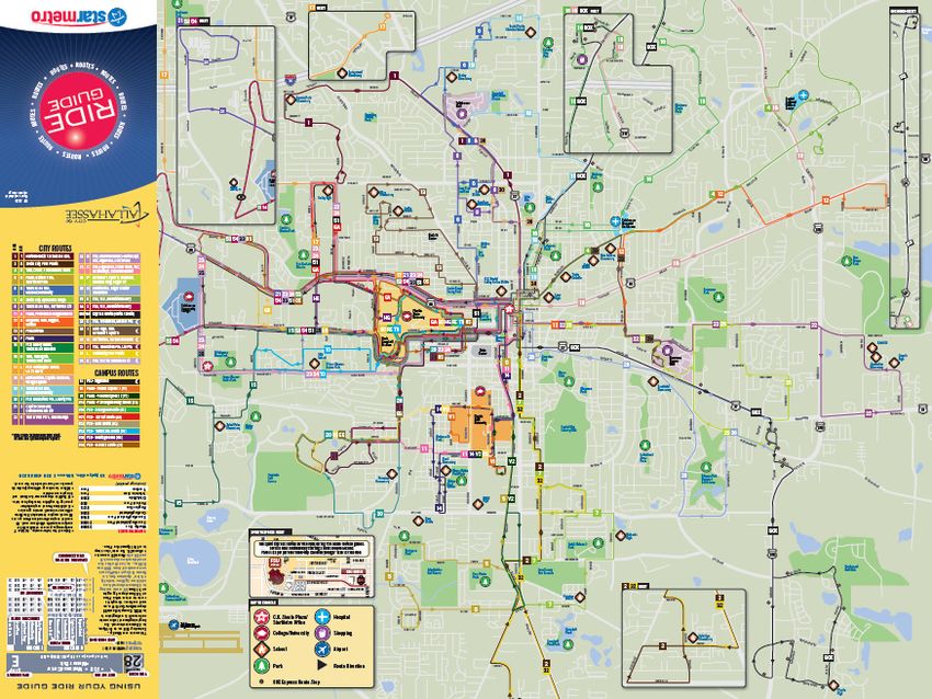
UF Campus Master Plan, 2010-2020,
                                                                          Year 2020 UF Transit System Analysis

Universities with similar student population size and community population size and character will
generally experience similar demands on the transit system. Although the University of Texas-
Austin has a similar student population size, the large population and urban character of Austin
gives a different dynamic to transit demand as compared to Gainesville. The demand, size and
operational characteristics of the bus transportation system were also considered. Arizona State
University was eliminated from the list of peer universities because it has access to a light rail
system, thus changing the dynamics of the bus system. Similarly, Michigan State University was
eliminated because the students do not ride for free on the Capital Area Transportation Authority’s
city bus routes. The academic programs of the universities and their research facilities were also
considered, using research school rankings and membership rosters for the Association of American
Universities (AAU) and Association of American Medical Colleges (AAMC). Another
consideration was the visual and operational distinction between campus bus service and city
transit.

Of 17 universities, five were selected as the peer universities to the University of Florida for these
transit analyses: University of Illinois at Urbana-Champaign, University of Michigan, University of
North Carolina at Chapel Hill, University of Virginia and Florida State University. While FSU
differs from UF in community character and rankings, it was included to serve as a logical Florida
comparison. The peer universities are compared in Table 1 below. These five universities and
their transit services were compared to UF for the bus route clarity and branding analysis.

                                                                                                            2
UF Campus Master Plan, 2010-2020,
Year 2020 UF Transit System Analysis
Table 1: University of Florida Peer Universities Comparison
2009
Does It Have No. Of Bus
2009-2010 2006 City Metropolitan Is It A Tier 1 Is The Campus Transit Accredited
School City, City A U-Pass Or Routes That Transportation AAU Other Campus And City
Student Population Statistical Research Service Distinguished Medical
Name State Character Universal Serve The Grade2 Member Notes Transportation Websites
Population Estimate Area School?1 From The City Service? School5
Access? Campus
Population
University of Gainesville, FL 50,691 108,6554 260,690 Suburban Yes Yes Yes. City routes are Nine routes A- Yes Yes RTS operates ~25 different city routes, http://parki http://go-
Florida / Small numbered below 100. circulate in and many of which stop near campus. There are ng.ufl.edu rts.com
Urban Campus routes are around campus; nine different campus routes that provide
numbered within the most city routes internal circulation. UF students, faculty,
100s. stop near staff and spouses can ride for free on any
campus fixed-route service.
Florida State Tallahassee, FL 40,255 159,0124 360,013 Urban Yes No - Tier 2 Yes. City routes are FSU provides A- No Yes FSU's Seminole Express bus system http://parki http://www.
University numbered. Campus seven campus provides service from almost every ng.fsu.edu/S talgov.com/st
routes are named. routes; seven apartment complex on the west side of eminole%20 armetro/
city routes serve Tallahassee to the FSU campus. StarMetro Express/Se
the campus. is Tallahassee's city bus system and includes minole%20E
campus shuttles at FSU and Florida A&M xpress.html
University.
University of Urbana, IL 41,918 38,6584 226,132 Suburban Students, Yes No. Some of the city Seven routes B+ Yes No UIUC is located between the twin cities of http://ww http://illinois
Illinois at / Small faculty and routes serve the campus, serve the Urbana and Champaign (combined pop of w.cumtd.co .edu/ds/detai
Urbana- Urban staff ride free but they are not named campus. ~100,000). MTD, the transit agency for m/ l?departmentI
Champaign by showing differently or otherwise the twin cities has routes that serve the d=illinois.edu
ID distinguished from the cities, most of which connect to the 203&sea
routes that do not serve University area. Some of these routes rch_type=&a
the campus. internally serve the campus. mp;skinId=22
40
University of Ann Arbor, MI 41,674 113,2064 347,563 Suburban Yes. Free for Yes Yes. City routes are Seven university A- Yes Yes UMich is separated into North Campus and http://pts.u http://www.
Michigan / Small UM students, numbered. Campus bus routes & South Campus, divided by a national mich.edu/ta theride.org/
Urban faculty & routes are named. eight city routes arboretum. The University operates its own king_the_bu
staff. serve the bus system with services in and between s/routes/
campus campuses. On campus bus service looks
comparable to UF, but no map with all the
routes exists on the website, although Magic
Bus shows the locations of the buses. The
Ride is Ann Arbor's city transit agency, and
has several routes that serve UM and
downtown. It also serves Ypsilanti, a town
to the east of Ann Arbor.
University of Chapel Hill, 28,916 49,9194 501,2285 Suburban CHT buses Yes No. Chapel Hill Transit About 20 to 25 B Yes Yes The Town of Chapel Hill, in partnership http://www.townofchapelhil
North NC / Small are free for provides service for the CHT routes with UNC and the Town of Carrboro, l.org/index.aspx?page=1175
Carolina at Urban everyone. university and town. serve the operates Chapel Hill Transit (CHT), a free
Chapel Hill UNC CAP Routes that serve the campus bus transit system within the town. CHT
members university are not provides local transit service for the
receive free distinguished from those University and its medical facilities.
Go-Pass to all that do not. Triangle Transit is a region-wide transit
TTA and agency that focuses on commuter markets
DATA buses by providing service between regional
destinations.
3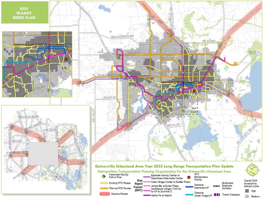
UF Campus Master Plan, 2010-2020,
                                                                                                                                                                                                                                                     Year 2020 UF Transit System Analysis

                                                                2009
                                                                                        Does It Have                                                     No. Of Bus
                                   2009-2010    2006 City    Metropolitan                                  Is It A Tier 1   Is The Campus Transit                                                     Accredited
    School           City,                                                    City      A U-Pass Or                                                      Routes That        Transportation    AAU                                     Other                              Campus And City
                                    Student     Population    Statistical                                    Research        Service Distinguished                                                     Medical
    Name             State                                                  Character    Universal                                                        Serve The            Grade2        Member                                   Notes                           Transportation Websites
                                   Population    Estimate       Area                                         School?1       From The City Service?                                                     School5
                                                                                          Access?                                                          Campus
                                                             Population

University of   Charlottesville,   20,895       42,2183      196,766        Suburban    UTS buses are      Yes              Yes. City routes are       UTS has six          A-               Yes      Yes          The University operates UTS, which              http://ww        http://www.
Virginia        VA                                                          / Small     free         for                    numbered.     University   routes that serve                                           provides free service through the campus        w.virginia.e     charlottesville
                                                                            Urban       everyone.                           routes are named.          the university                                              and hospital, sports facilities, and off-site   du/parking/      .org/index.as
                                                                                        Students,                                                      community.                                                  parking locations.          The City of         uts/index.ht     px?page=661
                                                                                        faculty     and                                                The CAT Free                                                Charlottesville operates the CAT, which         ml
                                                                                        staff ride CAT                                                 Trolley      links                                          provides service to the City and parts of
                                                                                        for free w/                                                    UVA            and                                          Northern Albemarle County. The two
                                                                                        ID.                                                            downtown.                                                   systems are not well integrated. The City
                                                                                                                                                                                                                   offers the Free Trolley, which connects the
                                                                                                                                                                                                                   University       area     to      downtown
                                                                                                                                                                                                                   Charlottesville.

1
  According to the Center for Measuring University Performance: The Top American Research Universities 2009 Annual Report
2
  According to www.collegeprowler.com
3
  2009 Census estimate
4
  2006 Census estimate
5
  According to the membership roster of the Association of American Medical Colleges (AAMC)

                                                                                                                                                                                                                                                                                       4
UF Campus Master Plan, 2010-2020,
                                                                          Year 2020 UF Transit System Analysis

BUS ROUTE CLARITY & BRANDING
Bus systems can be confusing and intimidating for first time riders, especially when a big transit
system has numerous routes or when more than one transit system provides service in an area. The
strategic use of colors, numbers, letters and other visual differentials can help riders to understand
which systems and routes serve certain destinations and locate the correct transit stop. Several bus
systems across the nation have used the concept of ‘branding’ to help riders identify certain
services. An express bus service may be identified by a different bus stop sign, the bus stop might
have a specially designed shelter with other amenities, and the buses themselves may look different.

OBJECTIVE
If the university’s transit system is too confusing, students and university employees will prefer not
to use it. The objective of this analysis is to determine how ‘user-friendly’ the RTS bus system is
and whether changes in the system branding would increase the usability of the transit system. The
branding techniques of the peer universities will provide a basis for comparison against those of the
University of Florida and RTS.

METHODOLOGY
The current transit system (RTS campus routes) for UF was examined to identify the branding
techniques used to distinguish the available routes and services, including the bus schedules and
other rider information guides, the colors and designs of the route labels, the bus stop signs and
amenities, and the buses themselves. The transit systems at several peer universities were similarly
examined, and the branding techniques of the different universities were compared. The system
maps of each system are provided following the recommendations section in Maps 1 through 6.
The system maps are at different scales and highlight the differences in service extent and
complexity.

COMPARATIVE ANALYSIS

CURRENT BRANDING TECHNIQUES
RTS designates nine bus routes as campus routes, which differ from the other city routes by
operating schedule. Students, faculty and staff employees of the University of Florida have
universal access to all RTS bus routes as part of a prepaid agreement between the University and
RTS. Map 1 shows the RTS system map for city routes.

The RTS rider guide materials provide easy-to-understand information about how to use the 28
weekday city routes, nine campus routes, and different routes and services for late nights, Saturdays

                                                                                                            5
UF Campus Master Plan, 2010-2020,
                                                                         Year 2020 UF Transit System Analysis

and Sundays. The printed City & Campus Bus Schedule is very comprehensive with system maps
showing the entire service area plus a detailed map for campus services. A large number of city and
campus routes serve the campus, but there is no map that shows the city and campus routes
together.

The routes are identified by color and number, although many of the routes are shown in similar
hues making it difficult to read, especially when three or more routes travel on the same road
segment.

Campus routes are differentiated from city routes by number. City weekday routes are numbered
1 to 99; campus weekday routes are numbered 100 to 199. Special weekend routes are in the
400s.

Two years ago, RTS updated the look of its buses and bus stop signs by replacing older generic-
looking buses and signs. Everything that bears the RTS name, including the buses, bus stop signs,
rider guides, and website, is now easily identifiable with a new cohesive blue and white color
scheme. RTS is continuing to expand the application of the paint scheme. Recently RTS added
reflective stickers to many of the bus shelters.

                                                        Older buses:

                                                        Source: Arthur-A (Flickr)
                                                        Date of photo: March 3, 2008

 New buses and bus stop signs:

 Source: Arthur-A (Flickr)                              Source: KD (Picasa)
 Date of photo: January 17, 2009                        Date of photo: August 4, 2009                      6
UF Campus Master Plan, 2010-2020,
Year 2020 UF Transit System Analysis
For most city routes, RTS riders can now track the buses through TransLoc TVS
(http://ufl.transloc.com), a real-time GPS information system that provides riders and transit
administrators with information on where the buses are and when the next bus is coming. Riders
can see a system-wide map of which routes are currently in service, each bus stop on each route,
how many buses are running, and the next arrival time at a certain stop. Especially for the student
riders, who are generally inclined to use the latest information technology to their benefit, this
application makes the RTS bus system very easy to understand.
The posting of route information
varies depending on customer
requests and the amount of activity
at a bus stop. Typically more
information is posted at off-campus
stops and where service is less
frequent. Riders may have trouble
using bus service at stops that lack
posted information, particularly if
they do not have a phone with
internet access.
The bus stops do not continue the
theme of the color-coded routes.
The above photo shows a bus stop
for Route 34 that does not match the
red coloring that identifies it in the
bus schedule or TransLoc
application.
7UF Campus Master Plan, 2010-2020,
Year 2020 UF Transit System Analysis
PEER REVIEW AND COMPARISON
The branding and route identification techniques of the transit systems of the five peer universities
were examined relative to the University of Florida
FLORIDA STATE UNIVERSITY
The Seminole Express routes provide transit
service within the FSU campus, to major off-
campus apartment complexes and to off-campus
university facilities like the Alumni Village and
Engineering School. StarMetro, Tallahassee’s
city transit service, has seven additional routes
that provide service within the FSU campus and
to off-campus housing. These routes connect to
the CK Steele Plaza, the main downtown transfer
center for transfers with the other StarMetro city Source: PARC, StarMetro
routes, providing links to major retail centers and
other destinations. FSU students, faculty and staff members ride for free on all StarMetro routes.
Map 2 shows the StarMetro system map.
StarMetro’s city routes and FSU’s Seminole Express appear to be
two different transit systems, although they are both operated by
StarMetro. The buses and bus stop signs look completely
different, making it easy to distinguish which system serves a
certain location.
StarMetro’s brand uses white, blue and red with the star logo for
identification. Buses are white, and stops are identified by the
white, blue and red star signs. The Seminole Express uses garnet
and gold (FSU colors) instead of white to offer a contrast. Buses
and bus stop signs are gold and garnet with the arrowhead icon.
Bus stops served by both systems will be signed for both.
Source: Renaissance Planning
Group
8
Source: Renaissance Planning GroupUF Campus Master Plan, 2010-2020,
Year 2020 UF Transit System Analysis
StarMetro uses a generic number system for its routes. The multitude of different routes and
colors make the StarMetro rider guide difficult to use. FSU’s Seminole Express uses route names
instead of numbers to identify routes. The school spirit inspired names do not identify the
destinations that each route serves, and are not more useful than a simple numbering system. Both
systems distribute a rider guide with system route maps and schedules. Seminole bus stop signs
include posted route and schedule information. Neither system uses real-time GPS technology for
rider information. While comparable in branding techniques, RTS’s rider information exceeds that
of StarMetro.
UNIVERSITY OF ILLINOIS AT URBANA-CHAMPAIGN
The University of Illinois relies on the Champaign-Urbana Mass Transit District (MTD) to provide
bus service in and around campus for students, faculty and staff. Seven of the 17 MTD bus routes
connect to and internally serve the campus. Map 3 shows the system map of the Champaign-
Urbana MTD.
MTD is a very user-friendly transit system. The route identification is simple and easy to
understand. Routes have both a route number and name; the name is usually a color with a few
exceptions. Spelling out the name of the color allows the system to have a large number of routes
without duplicating colors. Even though the colors of the Bronze, Brown and Gold routes may be
difficult to differentiate on a system map, the name and numbers (8 Bronze, 9 Brown, and 10 Gold)
helps to clarify routes. Buses display the route number, direction, color and end-of-line
destination, ensuring that riders know exactly which bus they are boarding and where it is going.
Source: Champaign-Urbana Mass Transit District
9UF Campus Master Plan, 2010-2020,
Year 2020 UF Transit System Analysis
What sets MTD apart from most other transit agencies is its use of real-time GPS technology,
known as STOPwatch technology, and the breadth and depth of information available to its riders.
The Google Transit Search feature on the MTD website allows you to find the exact location of the
nearest bus stop by entering a street, business or landmark. The website also allows you to find
which routes serve a specific bus stop and when the next buses will arrive. Figure 1 demonstrates
the website interface that shows riders which buses are serving a particular stop and their estimated
time of departure from that stop.
Figure 1: Bus Stop Lookup Screenshot
10UF Campus Master Plan, 2010-2020,
Year 2020 UF Transit System Analysis
STOPwatch technology is available on the internet, mobile phones via text messages, and displayed
at the bus stops. Each bus stop provides continuously updated real-time information on next bus
arrivals. Technology-savvy customers have a variety of ways to use the software, making transit
information always available and using the transit system increasingly convenient. Riders can even
sign up for custom alerts on their most-used routes. RTS riders would benefit from integrating a
variety of real-time services in addition to the TransLOC application. Increasing the availability and
avenues of information will appeal to choice riders.
Source: Imran Sobh (Flickr)
Date of photos: March 12, 2008
UNIVERSITY OF MICHIGAN
The University of Michigan is separated into North Campus and South Campus, divided by a
national arboretum. The University operates its own bus system with 11 bus routes in and between
campuses. Routes are identified by descriptive names only, no color or numbering system exists.
For example, the Commuter route serves the major parking lots, and the Northwood route serves
the Northwood housing areas on the North Campus. The university bus system uses neither
numbers nor colors to identify its routes. In fact, it does not have a system-wide map available on
its website.
It does have real-time GPS technology called Magic Bus that shows the location of each bus in the
transit system and estimates the expected wait at any transit stop. This technology is very similar to
what the University of Florida has with TransLoc.
11UF Campus Master Plan, 2010-2020,
Year 2020 UF Transit System Analysis
The Ride is Ann Arbor's city transit agency, and has eight routes that serve the University and
connect to downtown Ann Arbor. It also serves Ypsilanti, a town to the east of Ann Arbor. Map 4
shows the system maps for The Ride. The Ride identifies its routes with a generic number and
color system. The two systems are not well integrated. Route schedules and maps for The Ride
identify the possible transfers to university routes at major stops, but do not provide information on
where the university routes go. Similarly, the rider information for the university buses does not
include any information on The Ride. Bus stops provide limited information on routes and transfer
opportunities.
Although comparable in other characteristics, the University of Michigan’s campus bus service is
inferior compared to the services RTS provides for the University of Florida.
Source: Allison Gorsuch (Flickr) Source: Roland (Picasa)
Date of photo: Apr 25, 2009 Date of photo: Nov 4, 2008
12UF Campus Master Plan, 2010-2020,
Year 2020 UF Transit System Analysis
UNIVERSITY OF NORTH CAROLINA AT CHAPEL HILL
The Town of Chapel Hill, in partnership with UNC and the Town of Carrboro, operates Chapel
Hill Transit (CHT), a free bus transit system within the town. CHT provides local transit service
for the University and its medical facilities. Map 5 shows the system and campus maps for Chapel
Hill Transit. The routes are named corresponding to the areas which they serve, although this is
not always the case. For example the CL route serves Colony Lake, Sage Road and UNC
Hospitals; however, the D route serves Culbreth Road, Franklin Street and Eastowne. CHT does
not use a coordinated numbering or coloring system to identify its routes.
Some of CHT’s bus stops have signs that display real-time information on when the next bus is
coming. Although RTS’s TransLOC technology provides real-time information for smart phone
users, displaying information on the next bus arrival at the bus stops would benefit all passengers.
Source: NextBus
Triangle Transit is a regional transit system that focuses on serving region-wide commuter trips. It
uses a generic numbering system for route identification. The two transit systems have specific
color schemes that are easily distinguishable, which differs from the way RTS integrates campus and
city service.
13UF Campus Master Plan, 2010-2020,
Year 2020 UF Transit System Analysis
Source: Tastyduck (Wikimedia Commons) Source: Ildar Sagdejev (Wikimedia Commons)
UNIVERSITY OF VIRGINIA
The University of Virginia operates University Transit
Service (UTS), which provides free service through the
campus and hospital, sports facilities, and off-site
parking locations with six bus routes. The routes are
named according to the areas they serve. Like Chapel
Hill Transit, there is no consistent numbering or
coloring system for identification.
The City of Charlottesville operates Charlottesville
Area Transit (CAT), which provides service to the City
and parts of Northern Albemarle County, and offers
the Free Trolley, which connects the University area to
downtown Charlottesville. Map 6 shows the system
maps for CAT and UTS.
The Trolley bus is distinguishable because of its green
color. Charlottesville’s transit information guide
provides system maps, route maps and schedules for Source: City of Charlottesville website
both UTS and CAT systems. At certain bus stops, a
“bus finder” provides information on the arrival time of the next bus. RTS’s TransLOC technology
provides more information and is more convenient than CAT’s bus finder.
14UF Campus Master Plan, 2010-2020,
Year 2020 UF Transit System Analysis
RECOMMENDATIONS
Providing a comprehensive campus map that includes both campus routes and city routes that serve
the campus may be a graphic design challenge, but it will assist campus riders in understanding the
variety of routes available at different areas around the campus.
RTS should continue to develop GPS technology applications for rider information. Displaying
real-time information at transit stops will allow riders without smart phones to know when the
next bus will arrive. The Champaign-Urbana MTD’s variety of STOPwatch services is a model for
the developing rider information tools to make transit most convenient in the digital age.
To continue the color-identification theme of the routes, the route signs could be revised to show
the RTS logo at the top with blades below showing route information. The blades could be
removed as route changes occur, reducing the cost of updating the signs.
Providing route information at bus stops will help first-time riders and passengers without smart
phones understand the system. Blades underneath the bus stop sign display route information and
schedules and can be easily changed without taking down the whole sign.
RTS should continue to implement its new color scheme and look for ways to better differentiate
between the campus and city buses.
15UF Campus Master Plan, 2010-2020,
Year 2020 UF Transit System Analysis
Map 1: Route Maps of Peer Universities – University of Florida: Regional Transit System City Routes
Source: Regional Transit System, October 25, 2010
16UF Campus Master Plan, 2010-2020,
Year 2020 UF Transit System Analysis
Map 2 Route Maps of Peer Universities – Florida State University: StarMetro
Source: StarMetro, City of Tallahassee, October 25, 2010.
17UF Campus Master Plan, 2010-2020,
Year 2020 UF Transit System Analysis
Map 3: Route Maps of Peer Universities – University of Illinois at Urbana Champaign: Champaign -
Urbana Mass Transit District
Source: Champaign-Urbana Mass Transit District, October 25, 2010
18UF Campus Master Plan, 2010-2020,
Year 2020 UF Transit System Analysis
Map 4: Route Maps of Peer Universities – University of Michigan: The Ride
Source: The Ride, October 25, 2010.
19UF Campus Master Plan, 2010-2020,
Year 2020 UF Transit System Analysis
Map 5: Route Maps of Peer Universities – University of North Carolina at Chapel Hill: Chapel Hill Transit
Source: Town of Chapel Hill, October 25, 2010
20UF Campus Master Plan, 2010-2020,
Year 2020 UF Transit System Analysis
Map 6: Route Maps of Peer Universities – University of Virginia: University Transit System
Source: Charlottesville Area Transit, City of Charlottesville Source: University Transit Service, University of Virginia
21UF Campus Master Plan, 2010-2020,
Year 2020 UF Transit System Analysis
FACULTY CAB SERVICE
The University of Florida’s Physical Plant Division provides a free cab service for faculty and staff.
The Campus Cab service is intended for point-to-point transportation for official university
business on the Main Campus, Eastside Campus and Human Resources office. Reservations for the
cab service must be made at least 60 minutes in advance. This service is in operation Monday
through Friday from 7:45 AM to 4:15 PM.
OBJECTIVE
The objective of the analysis was to determine the effectiveness of the Campus Cab service,
especially since this service is provided in addition to the extensive bus transit coverage of the
university campus.
COMPARISON RESEARCH
Research was conducted to see if other universities offer a similar service and possible performance
metrics used to monitor the performance of the service. The University of Florida is unique among
its peers in offering a free on-campus cab service to faculty and staff for university business during
normal business hours. Many other universities like the University of Michigan, Florida State
University, Indiana University, and the University of Wisconsin provide a cab service in the event
that a student or university employee has a need for transportation after the daily bus service has
ended, usually referred to as a Guaranteed/Emergency Ride Home program. At the University of
Wisconsin, the Morgridge Center for Public Service will provide free cab rides to students who
volunteer at least eight times during a semester.
ANALYSIS METHODOLOGY
The Physical Plant Division (PPD) of the University of Florida provided count data for the cab
service for September 2010. These data documented how many times within the month the service
was used at each location. The data did not differentiate trip origins from destinations; it simply
provided the number of times the service was used at a location. University employees used the
cab service for a total of 2,288 pick-ups and drop-offs in September at 72 different locations. At 26
locations, the number of pick-ups and drop-offs exceeded 20 in that month, accounting for 2,010
trips or 88 percent of the total trips. These 26 locations were plotted with the campus and city
route alignments, as shown in Map 7.
22UF Campus Master Plan, 2010-2020,
Year 2020 UF Transit System Analysis
Map 7: Top 26 Most Popular Campus Cab Pick-up and Drop-off Locations
23UF Campus Master Plan, 2010-2020,
Year 2020 UF Transit System Analysis
RESULTS
Five of the 26 locations are not served directly by the campus bus routes, including the top two
locations, as shown in Table 2 below.
Table 2: Campus Cab Locations Not Directly Served by Campus Bus Routes
SEP 2010
# LOCATION
CAB COUNT
1 Human Resources Building (Bldg #3381) 251
2 Health Prof, Nursing & Pharmacy (HPNP) (Bldg #212) 227
9 Academic Research Building (Bldg #201) 80
14 Entomology-Nematology Building (Bldg #970) 60
18 East Campus Office Building (Bldg #1628) 52
These five locations have a total of 670 trips, accounting for one-third of the trips within the 26
locations. All five locations are served by the city routes, but the city routes do not provide
connecting services to other destinations within the campus. Although the majority of trips occur
at locations where campus transit service is available, the campus cab service provides a unique link
to university facilities outside of the campus transit service area. The entrances of the HPNP and
Academic Research Building are located just a few hundred feet away from the bus stops along
Center Drive. However, faculty and staff members may prefer to use the campus cab service
because of the door-to-door convenience. The notion that the bus transit is provided for the
students may also factor in to employee’s preference to take the campus cab.
RECOMMENDATIONS
The existing campus cab service appears to fill a void in connectivity and convenience as
demonstrated by its usage, and it should be continued until such time that more streamlined and
connected campus service can be provided. This service offers a travel time savings as long as the
rider remembers to call in advance. In the meantime, it should periodically be monitored to
determine adjustments that should be made.
A 2009 Transportation & Parking Survey conducted by UF indicated that 84% of faculty and staff
parking permit holders never use the Campus Cab service, and only 3% of respondents use the
Campus Cab frequently. In the same survey, 37% of respondents indicated they would be more
24UF Campus Master Plan, 2010-2020,
Year 2020 UF Transit System Analysis
likely to use on-campus transit if there was “on-demand door-to-door service.” These results
indicate that there may be a lack of awareness of the service among faculty and staff.
To more effectively evaluate the Campus Cab service, the Physical Plant Division could establish
acceptable performance measures and track relevant data (such as number of weekly trips and trip
origins and destinations). A database of more detailed usage statistics will help to identify ways to
improve the effectiveness of the cab service and could be compared to the costs of operating the
service.
DIRECTNESS TO DESTINATIONS
Transportation is always a means to an end. People will generally choose the travel mode and
route that is the quickest and most convenient. In order to provide the best and fastest service for
its riders, a transit system must reach main destinations quickly and directly. Combining transit
routes to serve multiple destinations may become too circuitous and increase the travel time to get
from a certain origin to a destination. Conversely, having too many direct routes may cause riders
inconvenience because of necessary transfers from one route to another. Transit agencies must find
a balance between the two to provide convenient and attractive service from point to point within
the entire transit service area.
OBJECTIVE
The objective of the analysis was to determine whether the current RTS routes connect campus
destinations efficiently. This analysis focused on answering whether the bus routes are taking the
most direct route relative to other potential route alignments. It is not a comparison of
transportation modes. The results of the analysis do not indicate whether taking the bus is easier,
more convenient, or more efficient than walking or driving. It simply indicates whether the
current RTS routes are too circuitous or inefficient.
METHODOLOGY
Five major on-campus destinations (attractors) and eight major on-campus generators were
selected for analysis. These particular destinations were selected because they are large buildings/
facilities and are used by a large number of students, faculty and staff members. To determine
whether the current bus routes provide direct service between these generators and attractors, the
shortest on-road distance between each generator and attractor was compared to the distance
traveled by a passenger riding the bus between the two points. For consistency, this analysis
assumes the starting points and end points are the bus stops located along the street closest to the
actual building and that buses can travel along these streets. Further detailed analysis would be
25UF Campus Master Plan, 2010-2020,
Year 2020 UF Transit System Analysis
required to determine any specific physical constraints that would limit bus movement in these
areas. These starting and end points are described below and shown in Map 8. Table 3 shows the
routes that serve each of these stops. The five attractors and their mapping points are:
1. Criser Hall & Union Drive: Walker Hall transit stop on the south side of Union Drive
2. Turlington Plaza & Newell Drive: Turlington Hall transit stop at the intersection of Stadium
Road and Newell Drive
3. Reitz Union & McCarty Drive: Reitz Student Union transit stop on McCarty Drive, just north
of the intersection with Museum Road
4. Health Science Center & Center Drive: Shands Hospital at Basic Science Building transit stop
on the west side of Center Drive, north of the intersection with Mowry Road
5. The Hub & Stadium Road: The Hub transit stop where Stadium Road becomes Buckman
Drive, between the Hub building and the Computer Sciences/Engineering building
The eight generators and their mapping points are:
1. Beaty Towers & Museum Road: Beaty Towers transit stop on south side of Museum Road,
west of SW 13th Street
2. Park and Ride Lot 1 & Cultural Plaza: Cultural Plaza Park and Ride 1 transit stop within Park
and Ride Lot 1 off of Hull Road.
3. Commuter Lot & Gale Lemerand Drive: Commuter Lot Parking Garage transit stop on the
west side of Gale Lemerand Drive, across from the water reclamation sludge building
4. Hume Hall & Museum Road: Hume Hall transit stop on the south side of Museum Road, in
front of the Hume East Residence building
5. Springs Residential Complex & Stadium Road: Springs Residential Buildings transit stop on
Fraternity Drive, west of the intersection with SW 23rd Street
6. Corry Village / Law School & Village Drive: Corry Village transit stop on Village Drive at
the intersection with Corry Circle and West Fraternity Row
7. Lakeside Complex & Radio Road: Lakeside Residential Buildings transit stop on the south
side of Radio Road in front of Lakeside Commons
8. Maguire Village / Wellness Center & Radio Road: Maguire Village transit stop along the
west side of Bledsoe Drive, across from Maguire Field and the Recreation Sports Maintenance
Building
26UF Campus Master Plan, 2010-2020,
Year 2020 UF Transit System Analysis
Table 3: RTS Campus Bus Routes Serving each Destination and Generator
RTS Campus Routes Serving Bus
Destination/Generator Bus Stop
Stop
Criser Hall 121, 126, 127
Turlington Plaza 120, 122, 125, 127
Reitz Union 117, 120, 122, 125, 126
Health Science Center 117, 121, 122, 126
The Hub 118, 119, 120, 121, 122, 125, 126
Beaty Towers 121, 126, 127
Park and Ride Lot 1/Cultural Plaza 118
Commuter Lot 121, 122, 126
Hume Hall 118, 120, 125, 126
Springs Residential Complex 119, 120, 125, 126
Corry Village/Law School 119
Lakeside Complex 119, 125, 126
Maguire Village/Wellness Center 119, 125, 126
27UF Campus Master Plan, 2010-2020,
Year 2020 UF Transit System Analysis
Map 8: Origins and Destinations
28UF Campus Master Plan, 2010-2020,
Year 2020 UF Transit System Analysis
The RTS spring 2010 City & Campus Bus Schedule provided information on the bus routes and bus
stops. The fall 2010 schedule was released after the analysis was completed. The slight differences
of route additions and deviations do not affect the analysis results.
The shortest on-road distance between each of the destinations was calculated using Google Maps
driving directions. The distance traveled by taking the bus was determined assuming that
passengers prefer to utilize the routes that serve the bus stops from which their trip starts and ends.
A more direct route may be available by walking to another bus stop, as noted in the footnotes of
Table 5. Of the routes that serve the starting and end bus stops, the calculated distance assumes
passengers will take the most direct route available and avoid transferring to a second bus route.
The analysis did not consider frequency of the routes as a factor in route choice; only distance to
destinations. Frequency is a temporal factor, whereas distance is a spatial factor. Only RTS
campus routes were used in the analysis.
The objective of the analysis is to determine whether the existing bus routes are traveling the most
direct route; it does not account for factors that would influence other transportation modes such
as the parking availability or the location of internal pedestrian and bike paths. The travel distances
include only roads where vehicles are permitted.
ANALYSIS
Most of the campus attractors are within one mile of each other and within two miles of campus
generators. Bus travel distances vary. Most are within two miles; some reach five miles or more.
Table 4 shows the shortest on-road travel distance as calculated by Google Maps. The shortest on-
road travel distances from any of the five attractors to any of the attractors are one mile or less.
Generally, the shortest on-road travel distance between a generator and an attractor ranges
between one and two miles. Beaty Towers, the Commuter Lot and Hume Hall are within one mile
of the campus attractors. One mile is roughly a 20 minute walk. A person may prefer to walk to a
destination that is one mile away or closer, especially if the service is not directly to the destination
or from the origin.
29UF Campus Master Plan, 2010-2020,
Year 2020 UF Transit System Analysis
Table 4: Shortest Driving Distance to Destinations
Park and Ride Lot 1/ Cultural Plaza
Maguire Village/ Wellness Center
Springs Residential Complex
Corry Village/ Law School
Health Science Center
Lakeside Complex
Turlington Plaza
Commuter Lot
Beaty Towers
Reitz Union
Hume Hall
Criser Hall
The Hub
Shortest On-Road Travel
To
Distance (miles)
From 1 2 3 4 5 6 7 8 9 10 11 12 13
Criser Hall 1 0.2 0.6 0.9 0.3 0.6 2.3 1.0 0.9 1.0 1.2 1.8 2.1
Turlington Plaza 2 0.2 0.4 0.7 0.2 0.4 2.1 0.8 0.7 0.9 1.2 1.6 1.9
Reitz Union 3 0.6 0.4 0.4 0.6 0.4 1.7 0.4 0.3 0.9 1.0 1.2 1.5
Health Science Center 4 0.9 0.7 0.4 1.0 0.8 1.4 0.5 0.6 1.2 1.3 1.6 1.8
The Hub 5 0.3 0.2 0.6 1.0 0.7 2.1 0.8 0.7 0.7 1.0 1.6 1.9
Beaty Towers 6 0.6 0.4 0.4 0.7 0.7
Park and Ride Lot 1/ Cultural Plaza 7 2.3 2.1 1.7 1.4 2.0
Commuter Lot 8 1.0 0.9 0.4 0.5 0.8
Hume Hall 9 0.9 0.7 0.3 0.6 0.7
Springs Residential Complex 10 1.0 0.9 0.9 1.2 0.7
Corry Village/ Law School 11 1.2 1.2 1.0 1.3 1.0
Lakeside Complex 12 1.9 1.7 1.3 1.5 1.6
Maguire Village/ Wellness Center 13 2.1 2.0 1.9 1.8 1.9
Attractors
Generators
Table 5 shows the distance a passenger would travel while riding the bus. The background color of
the cells corresponds to the route traveled. The white cells indicate there is no direct service
connection between the starting bus stop and end bus stop, and the details of the routes taken are
described in the table’s footnotes. Route 117 was considered in the analysis, but was not selected
for any trip as the other routes provided more direct service.
30UF Campus Master Plan, 2010-2020,
Year 2020 UF Transit System Analysis
Table 5: Bus Travel Distance to Destinations
31UF Campus Master Plan, 2010-2020,
Year 2020 UF Transit System Analysis
A handful of the trips are not served directly by the campus routes, as indicated in white, due to the
loop style routes. Passengers can usually walk to a nearby stop to access a more direct route, or
simply walk when the distance is a half mile or less.
The bus travel distances range from 0.2 miles to 7.5 miles, with the average around two miles.
The average of shortest on-road travel distances is one mile. Routes 122 (UF North/South
Circulator) and 126 (UF East/West Circulator) generally have longer travel distances because their
routes are longer and they serve more destinations. Because the routes travel in a loop, the
distance to travel in one direction may be significantly longer than the other direction. For
example, Route 126 travels 1.0 miles from the Springs Residential Complex to Criser Hall, but it
takes 5.2 miles to travel from Criser Hall to the Springs Residential Complex.
Many of the trips to and from the Park and Ride Lot 1 transit stop and Corry Village require a
transfer between bus routes. These trips are shown in white in Table 3, and explained in the
footnotes to the table. Generally, students coming from Corry Village must transfer at the Hub to
catch another bus route that serves the eastern portion of campus and Museum Road. When
returning to Corry Village, several of the bus routes loop towards Corry Village (i.e. Route 120
West Circulator and Route 126 UF East/West Connector). A passenger could take one of these
routes without transferring; in this case they would get off at Fraternity Row and walk the rest of
the way.
The Park and Ride Lot 1 transit stop is only served directly by one campus route. Route 118 serves
the western portion of campus and terminates at the Hub. Two weekday city routes serve this
transit stop (Routes 20 and 21); however neither go further into campus than Reitz Union, which is
where Route 117 terminates as well, providing minimal additional service coverage to on-campus
destinations. No direct service connection exists from the Park and Ride Lot 1 transit stop to four
of the five campus attractors. To access the campus attractors from Park and Ride Lot 1,
passengers can transfer at the Hub and ride less than a half-mile to reach their destination. The
return trips are significantly longer; passengers must ride the connecting routes for most of their
loop before reaching the Hub to transfer to Route 118. Alternatively, passengers could walk the
distance between the Hub and the final destination to avoid waiting for a transfer; however this was
inconsistent with the assumptions of the analysis. These alternative options are noted in the
footnotes of Table 5.
Table 6 shows the difference between the shortest on-road distance and the bus travel distance, if
any, and highlights those trips where taking the bus would result in a one-mile deviation or more
with red font.
32UF Campus Master Plan, 2010-2020,
Year 2020 UF Transit System Analysis
In four instances, the distance traveled by the bus is greater than the shortest on-road travel
distance by four miles or more, as highlighted in yellow in Table 6:
• Reitz Union to Beaty Towers on Route 126
• Hume Hall to Health Science Center on Route 126
• Reitz Union to Criser Hall on Route 126
• Criser Hall to Springs Residential Complex on Route 126
Blank cells indicate that the bus travels the most direct on-road travel distance.
33UF Campus Master Plan, 2010-2020,
Year 2020 UF Transit System Analysis
Table 6: Difference between Bus Travel Distance and Shortest Road Distance
34UF Campus Master Plan, 2010-2020,
Year 2020 UF Transit System Analysis
Assuming the bus travels at an average speed of nine miles per hour, Table 7 converts the distance
difference from Table 6 to minutes. These numbers represent the extra time a passenger spends
riding the bus compared to if the bus traveled the shortest on-road distance between that
passenger’s starting and end stops. The average travel speed of nine miles per hour accounts for
dwell time at transit stops (time allocated for passengers boarding and alighting). An average travel
time of nine miles per hour is a RTS-specific performance standard. Similar to other campus
experiences, nine miles per hour is an average speed that can be achieved in a dense urban setting
with a high level of pedestrian activity. Accounting for this assumption, the four longest trips are
over 25 minutes and highlighted in yellow.
Table 7: Difference in Travel Time between Driving and Taking the Bus
35UF Campus Master Plan, 2010-2020,
Year 2020 UF Transit System Analysis
RESULTS
Generally the areas that have the longest bus travel times are the areas in the southwestern portions
of campus, as all of the campus attractors are located in the northeastern side of campus. Corry
Village and the Park and Ride Lot 1 are particularly challenging because the routes that directly
serve these areas do not directly connect to other parts of the campus.
Several of these attractors are within easy walking distance of the destinations. Reitz Union is
centrally located, only 0.4 miles away from Beaty Towers and 0.6 miles from Criser Hall. Hume
Hall is only 0.6 miles from the Health Science Center. Most people will choose to walk 10 minutes
instead of waiting for the bus for such a short distance.
Many of these longer bus travel times are due to the looping bus routes. The origins and
destinations may be close to each other, but because the bus travels in only one direction the bus
will take the long way around. For example, Route 126 travels directly from the Springs
Residential Complex to Criser Hall. From there it continues to the east to serve the eastern
campus boundary, travels south along Center Drive and around the Engineering buildings, and
loops to serve the Lakeside complex and Corry Village before returning to Springs. Most likely,
riders will walk less than one quarter-mile to the Turlington Hall bus stop and take Route 120 to
Springs, only a 1.3 mile bus ride.
The Park and Ride Lot 1 transit stop is only served by one campus route. To reach on campus
destinations, passengers can take Route 118 to the Hub and either transfer to another bus or walk
the remaining distand.
RECOMMENDATIONS
Ultimately the campus bus routes provide a good balance between serving multiple destinations and
providing direct service. Inherently, transit routes do not provide the most direct path of travel
when multiple destinations are considered. Further, transit routes must be designed within the
context of resources allocated for the services provided. More direct service equates to more
allocation of resources (capital investments in buses and operational expenses). To further cause
complexity, university settings provide a unique travel dynamic, in that individuals travel between
multiple locations that both serve as origins and destinations. A campus transit route system must
be able to accommodate multiple alternatives to reach multiple locations in order to effectively
serve the targeted transit users. Because of this, a loop type route style is used. If transit routes
were to be realigned to provide specific direct service, there will be locations with no access to
transit service. It can be assumed that some individuals will walk further to a bus stop or choose to
walk to a destination that is not served, but this will have an impact on ridership as well as campus
36You can also read