Goomalling Bike Plan 2020 to 2030 - Shire of Goomalling
←
→
Page content transcription
If your browser does not render page correctly, please read the page content below
Goomalling Bike Plan
2020 to 2030

Prepared by: GTA Consultants (WA) Pty Ltd for Shire of Goomalling
on 20/04/20
Reference: W1219429
Issue #: B
Goomalling Bike Plan
             2020 to 2030

             Client: Shire of Goomalling

             on 20/04/20

             Reference: W1219429

             Issue #: B

             Quality Record
               Issue      Date                 Description                 Prepared By          Checked By   Approved By   Signed

                A-Dr      02/04/2020 Draft                                 A. Zhang             T. Judd      T. Judd
                 A        08/04/2020 A-Final                               A. Zhang             T. Judd      T. Judd

                 B        20/04/2020 B-Final                               A. Zhang             T. Judd      T. Judd

                       © GTA Consultants (WA) Pty Ltd [ABN 41 143 437 174] 2019
                       The information contained in this document is confidential and
                       intended solely for the use of the client for the purpose for which it
                       has been prepared and no representation is made or is to be implied
                       as being made to any third party. Use or copying of this document in
                       whole or in part without the written permission of GTA Consultants
GTA Report

                       constitutes an infringement of copyright. The intellectual property                             Melbourne | Sydney | Brisbane
                       contained in this document remains the property of GTA Consultants.
                                                                                                                             Adelaide | Perth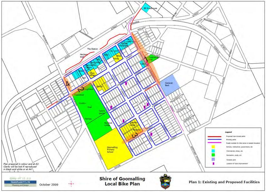
EXECUTIVE SUMMARY

       W1219429 // 20/04/20 // Issue: B
       Goomalling Bike Plan, 2020 to 2030   i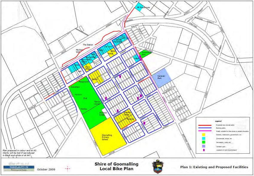
EXECUTIVE SUMMARY
Goomalling is a growing townsite in the Wheatbelt region of Western Australia, approximately 132km north-
east of Perth. This bike plan has been prepared for the Goomalling townsite and focuses on understanding
the barriers to cycling and the community’s needs and desires through community consultation and
recommending the appropriate best practice infrastructure for the network. This medium to long term plan is
intended to support the development of Goomalling’s bike network over the next 10 years. The vision for this
bike plan is:

    “To create a connected and safe cycling network
           for all members of the community.”
The Bike Plan’s overall goal is to provide an effective and efficient active transportation network. To achieve
this goal, some objectives have been formed. The objectives of this bike plan are:

•    Support cycling for local trips for community members of all ages
•    Create a connected cycling network
•    Create a safe cycling network for the community
•    Increase accessibility of the existing network
•    Utilise existing opportunities to expand the network.

The Goomalling townsite currently has a reasonable path network, with paths generally on both sides of most
roads. However, the existing network is in need of repair or upgrading to a shared path standard. The
existing network comprises of:

•    4.6km of concrete shared paths,
•    7km of gravel pathways and
•    9.5km of pathways to a footpath standard.

This bike plan also identifies the cycling network hierarchy consistent with the Department of Transport’s
Cycling Infrastructure Hierarchy (Network Principles) for the road network within the Goomalling townsite.

Throssell Street, Railway Terrace and Goomalling-Toodyay Road are identified as primary routes as they are
located adjacent to major roads and provide access to major destinations including the Town’s commercial
strip. Quinlan Street, Hoddy Street and Forrest Street have been identified as secondary routes, providing
connections between primary routes and major activity centres. All other routes have been identified as local
routes. Figure i shows the network hierarchy and table i provides a summary of the proposed network
features.

                                                              W1219429 // 20/04/20 // Issue: B
                                                              Goomalling Bike Plan, 2020 to 2030                  ii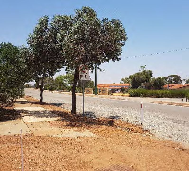
Figure i.   Cycling Network Hierarchy

Table i:    Proposed Network Summary

Type of Route Road                        Future Form

               Throssell Street / Main    High quality shared path connecting the Caravan Park and Swimming
               Street / Northam-Pithara   Pool to the Town Centre in the short to medium term.
               Road                       Connections to other town sites and Slater Home Stead in the long term.

Primary Route Railway Terrace             Parking protected on-road cycle lanes on both sides.

                                          High quality shared path to the northern side (potentially behind the
               Goomalling-Toodyay Road    existing trees) connecting the new development of Hennessey Place
                                          through to the primary school and Oval.

                                          2.5m wide shared path on the western side of Hoddy Street with
                                          connections at intersections (kerb ramps)
               Hoddy Street                                                   OR
                                          Upgrade the entire street to a Safe Active Street to improve safety and
                                          amenity for all users and residents who live along it

                                          Tree protected on-road cycling as part of the upgrade, sealing and
Secondary                                 kerbing of the road.
Route          Quinlan Street                                                 OR
                                          2.5m wide shared paths on both sides of the road, transitioning on road
                                          through the filtered permeability section near the Recreation Hub.

                                          Parking protected or tree protected on-road cycling (see examples in
                                          Section 9.3.2)
               Forrest Street
                                                                            OR
                                          2.5m wide shared paths on both sides of the road

                                          2.5m wide Shared Path on both sides
Local Routes   All other roads
                                          Repair cracks and lifted paths as upgrades are required.

                                                             W1219429 // 20/04/20 // Issue: B
                                                             Goomalling Bike Plan, 2020 to 2030                     iii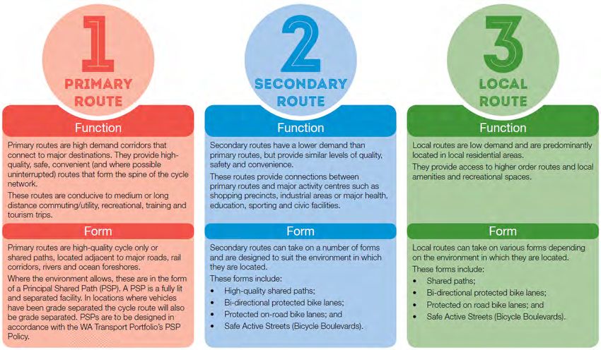
The following are the top priorities of this bike plan and have taken usage, attractions and community
consultation comments into consideration.
1.    Kerb ramp upgrades – kerb ramp connections should be constructed as a priority to ensure a
      continuous and connected network. Connections to Hoddy Street and Quinlan Street are considered
      particularly important. The kerb ramp locations are shown in purple (crossing points) in Figure 10.1.
2.    Shared Path (3.0m wide) connection along:

      o    Throssell Street from Railway Terrace to Goomalling Caravan Park.
3.    Path connection (minimum 2.5m for a Shared Path) to complete the missing links along:

      o    Bowen Street between Hoddy Street and Forrest Street.

      o    High Street between James Street and Throssell Street.
4.    Pump park access path to connect users through the Recreation Hub but also provide children with
      access to the pump park.
5.    On-road protected cycle lanes along Railway Terrace.
6.    Safe Active Street along Hoddy Street
7.    Closure of Quinlan Street between Lockyer Street and Hoddy Street, as set out in the Goomalling
      Recreation Hub Master Plan.
8.    Protected on-road cycle lanes along Quinlan Street.
9.    Bicycle parking at the Goomalling Primary School, Recreation Hub, Railway Terrace Commercial Strip,
      Swimming Pool and Goomalling District Hospital.
10.   Seating at the Recreation Hub and near the Goomalling District Hospital.
11.   Water fountains at the Recreation Hub and Swimming Pool.
12.   Bicycle repair stations at the Pump Park, Recreation Hub and Swimming Pool.

                                                             W1219429 // 20/04/20 // Issue: B
                                                             Goomalling Bike Plan, 2020 to 2030               iv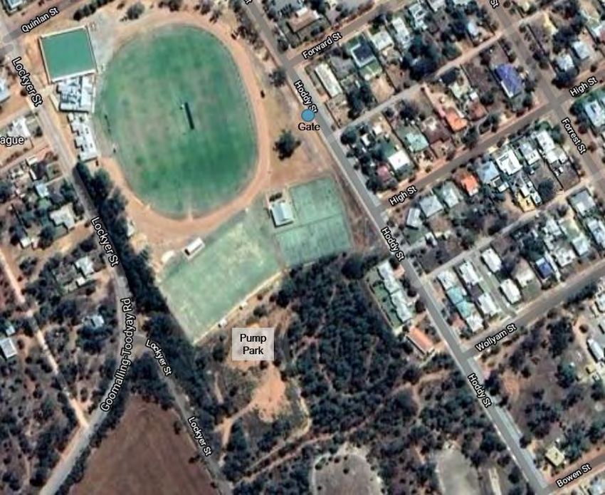
CONTENTS
1.   Background                                                                    1

     1.1. Introduction                                                             1

     1.2. Purpose                                                                  1
2.   Vision and Objectives                                                         3

     2.1. Guiding Principles                                                       3

     2.2. Vision                                                                   4

     2.3. Goal and Objectives                                                      4

     2.4. Key Initiatives                                                          4
3.   Existing Network                                                              5

     3.1. Understanding Goomalling                                                 5

     3.2. Strategic Guidance                                                       7

     3.3. Behaviour Change                                                        13

     3.4. Main Town Amenities                                                     14

     3.5. Shire Development                                                       16

     3.6. Road Network                                                            17
4.   Constraints                                                                  20

     4.1. Heavy Vehicle Demand                                                    20

     4.2. Intersection Widths                                                     22

     4.3. Crossing Opportunities                                                  23

     4.4. Path Quality                                                            25
5.   Opportunities                                                                26

     5.1. Parks and Reserves                                                      26

     5.2. Volumes and Speed of Streets                                            27

     5.3. Wide Street Treatments                                                  27

     5.4. Recreation Hub                                                          28

     5.5. Schools                                                                 28

     5.6. Network Repairs and Upgrades                                            28

     5.7. Funding Opportunities (Programs)                                        29
6.   Initial Consultation                                                         30

                                             W1219429 // 20/04/20 // Issue: B
                                             Goomalling Bike Plan, 2020 to 2030
7.   Community Workshop                                                                                 32

8.   Cycling Network Hierarchy                                                                          33

     8.1. Primary Routes                                                                                35

     8.2. Secondary Routes                                                                              36

     8.3. Local Routes                                                                                  37

     8.4. Training Routes and Tourist Trails                                                            39
9.   Infrastructure Improvements                                                                        40

     9.1. Short Term Improvements – Network Improvements                                                40

     9.2. Short Term Improvements – End of Trip Facilities                                              40

     9.3. Medium to Long Term Improvements                                                              43
10. Implementation Priority                                                                             49

11. Conclusion                                                                                          51

Appendices
A.   Active Travel Questionnaire Survey

B.   Cycling Network Hierarchy

C.   Cycling Network Features, End of Trip Facilities

Figures
     Figure i.     Cycling Network Hierarchy                                                             iii
     Figure 1.1:   How does cycling and walking benefit you and the community?                           2
     Figure 3.1:   Existing and Proposed Bike Network – 2009 Bike Plan                                   5
     Figure 3.2:   Existing Gaps in the Network                                                          6
     Figure 3.3:   Department of Transport’s Cycling Infrastructure Hierarchy (Network Principles)       8
     Figure 3.4:   Department of Transport’s Cycling Infrastructure Hierarchy (Complementary Network)    8
     Figure 3.5:   Cycling Network Hierarchy Typologies                                                  9
     Figure 3.6:   Map of Town Amenities                                                                14
     Figure 3.7:   Shire of Goomalling Local Planning Scheme Map                                        16
     Figure 3.8:   Network Posted Speed Limits                                                          17
     Figure 3.9:   Road Hierarchy                                                                       18
     Figure 3.10: Traffic Counts and Heavy Vehicle Percentage                                           19
     Figure 4.1:   MRWA RAV Network                                                                     20

                                                    W1219429 // 20/04/20 // Issue: B
                                                    Goomalling Bike Plan, 2020 to 2030
Figure 4.2:    Network Traffic Volumes                                                   21
    Figure 4.3:    Railway Terrace – 30m Road Reserve                                        22
    Figure 4.4:    Quinlan Street – 30m Road Reserve                                         22
    Figure 4.5:    Bowen Street – 20m with unsealed shoulders                                22
    Figure 4.6:    Salmon Gum Way – Unsealed Road                                            22
    Figure 4.7:    Crossing in one direction only                                            23
    Figure 4.8:    Unsealed crossing point between path and carriageway                      23
    Figure 4.9:    Pump Park Location Aerial                                                 24
    Figure 4.10: Examples of lifted, cracked or gravel covered paths                         25
    Figure 5.1:    Potential additional access to the Pump Park                              26
    Figure 5.2:    40km/h Trial – City of Vincent                                            27
    Figure 5.3:    Examples of Filtered Permeability                                         28
    Figure 8.1:    Cycling Network Hierarchy                                                 33
    Figure 8.2:    Cycling Network Proposals                                                 34
    Figure 8.3:    Trail along a Utility Corridor                                            39
    Figure 8.4:    Trail along a Fire Break                                                  39
    Figure 9.1:    Location of End of Trip Facilities                                        41
    Figure 9.2:    Bike Repair Stations                                                      42
    Figure 9.3:    Example Drink Fountains                                                   42
    Figure 9.4:    Shared Path General Design Standards                                      45
    Figure 9.5:    Examples of off road cycle infrastructure and Shared Paths                46
    Figure 9.6:    Filtered Permeability                                                     47
    Figure 9.7:    Signage                                                                   48
    Figure 9.8:    Your Move Cycle Safety and Directional Signage                            48
    Figure 10.1:   Cycling Network Upgrade Requirements                                      50
    Figure 11.1:   Cycling Network                                                           51

Tables
    Table i:       Proposed Network Summary                                                  iii
    Table 7.1:     Workshop Comment Summary                                                  32
    Table 9.1:     Protected on-road cycling to general traffic examples                     44
    Table 11.1:    Key cycling and walking network plan recommendations                      51

                                                        W1219429 // 20/04/20 // Issue: B
                                                        Goomalling Bike Plan, 2020 to 2030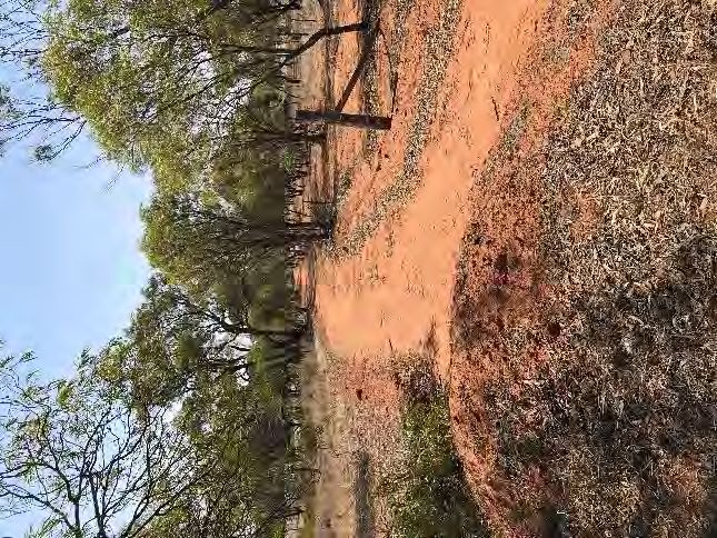
BACKGROUND

1. BACKGROUND
1.1. Introduction
Goomalling is located within the Wheatbelt Region of Western Australia, within the Shire of Goomalling and is
approximately 132km north-east of Perth. Goomalling is a growing townsite due to its proximity to Perth.

As part of the preparation of this bike plan, the following has been undertaken:

    i.    Background and literature review of strategic documents
   ii.    Desktop review of the existing cycling network
  iii.    Site analysis and ride through of the Goomalling townsite
 iv.      Online consultation
   v.     Development of a draft cycling network plan
 vi.      Workshop consultation
 vii.     Draft and final bike plan.

1.2. Purpose
Active travel is an important part of the transport network. This can include, but is not limited to, cycling and
walking. To support a safe and connected network, supporting infrastructure is required to ensure that active
transport can be a more viable transport option, particularly where external factors such as the temperature
can have an impact.

The Goomalling Town Centre already benefits from an extensive footpath network, which can help support an
active community. However, there are a number of gaps in the network. These are addressed and discussed
in this Bike Plan.

                                                             W1219429 // 20/04/20 // Issue: B
                                                             Goomalling Bike Plan, 2020 to 2030                     1
BACKGROUND
Figure 1.1: How does cycling and walking benefit you and the community?
W1219429 // 20/04/20 // Issue: B
Goomalling Bike Plan, 2020 to 2030 2VISION AND OBJECTIVES
2. VISION AND OBJECTIVES
2.1. Guiding Principles
Of utmost importance for any cycle and pedestrian network is to ensure the network adheres to the five
guiding principles to network planning: Safety, Directness, Coherence, Attractiveness and Comfort.
2.1.1. Safety
A well-designed cycle network improves and enhances the road safety of riders, pedestrians and motorists.
This includes:
• Intersections should be designed to explicitly include bicycles as well as other categories of road users.
Special intersection designs that include a path for bicycle riders are an important element of integrated
network design.
• Mid-block treatments need to provide safe and easy crossings for riders and pedestrians on major
roads.
• Public lighting and other features that improve personal safety are also crucial. Particularly for routes
more likely to be used at night, or for pedestrian crossings (both formal controlled and uncontrolled)
which should have appropriate Discrimination Disability Act (DDA) compliant design.
2.1.2. Directness
The cycling network should be as direct as safely practicable and based on desire lines. Long detours should
be avoided, as this often deters users. Indirect cycle routes or excessive delays may lead cyclists to choose
more direct routes with greater risk.
2.1.3. Coherence
Connected network linking people to places via strategic and local routes is an important aspect. The
network should be continuous and be very clear to the user where the facility leads. This can be in the form of
way finding and signage. The quality of network facilities should also be consistent throughout the length of
the route regardless of whether the facility uses a separated or shared road profile.
2.1.4. Attractiveness
Enjoyable cycling and walking requires attractively designed and located facilities. The network should
address the community’s needs in order to be attractive. Attractiveness can also be increased through
awareness including clear well-placed signposting which should indicate major destinations, while centre
lines and edge lines should indicate the serious transport intent of the off-road sections of routes. Cycle
routes should also feel like socially “safe” places to be.
2.1.5. Comfort
The bicycle and pedestrian network must be easy to use for all types of riders and pedestrians. A smooth
well-maintained riding surface (free of debris) is essential both for comfort and operating safety. Effective
intersection treatment is critical to ensure comfortable and safe crossing for cyclists and pedestrians.
W1219429 // 20/04/20 // Issue: B
Goomalling Bike Plan, 2020 to 2030 3VISION AND OBJECTIVES
2.2. Vision
This bike plan will guide the future network to ensure connectivity between town amenities ensuring it has a
strong community focus providing a safe and connected local network. On this basis, this bike plan has the
vision:
“To create a connected and safe cycling network
for all members of the community.”
2.3. Goal and Objectives
The Bike Plan’s overall goal is to provide an effective and efficient active transportation network, which is
consistent with the Shire of Goomalling Strategic Community Plan 2019.
To achieve this goal, some objectives have been formed. The objectives of this bike plan are:
• Support cycling for local trips for community members of all ages
• Create a connected cycling network
• Create a safe cycling network for the community
• Increase accessibility of the existing network
• Utilise existing opportunities to expand the network.
2.4. Key Initiatives
The following key initiatives together will work toward achieving the proposed objectives.
• Plan and deliver a connected network of “safe cycle routes” that achieves:
o Increased active travel through the Town
o Improved access to retail and recreational attractors
o Safe routes to local schools.
• Plan and deliver appropriately located end of trip facilities for the community’s needs including rest
points / seating, water fountains and bike parking.
W1219429 // 20/04/20 // Issue: B
Goomalling Bike Plan, 2020 to 2030 4EXISTING NETWORK
3. EXISTING NETWORK
3.1. Understanding Goomalling
The current cycling network in Goomalling comprises of a mix of paths including concrete, gravel and other
pathways that link the residential area to the town amenities. Goomalling has a large quantity of open spaces,
parks and reserves of significance, which could be connected to the bicycle network.
The Shire have advised that the town currently comprises of:
• 4.6km shared path (concrete)
• 7km gravel pathways
• 9.5km of pathways to a footpath standard.
In the 2009 Goomalling Bike Plan, it was identified that there were existing paths on at least one side of each
street between Railway Terrace, Throssell Street, Eaton Street and Lockyer Street, with the exception of
Throssell Street between Wollyam and Slater Streets and Lockyer Street south of Goomalling-Toodyay Road.
Figure 3.1: Existing and Proposed Bike Network – 2009 Bike Plan
Following a site inspection of the town, it was noted that a number of initiatives identified in the 2009 Bike
Plan have been completed. These are identified below.
• A section of the Priority 1 Project: Shared Path – Caravan Park to BP Roadhouse has been constructed.
The constructed section is approximately 225m, between Railway Terrace and the BP Roadhouse.
W1219429 // 20/04/20 // Issue: B
Goomalling Bike Plan, 2020 to 2030 5EXISTING NETWORK
• One of the five Priority 5 Projects: New Paths Program have been constructed, which includes Quinlan
Street between Helena Street and Maher Street. Funding has been successful for a path on the
northern side of Bowen Street between Forrest Street and Hoddy Street. These projects will be carried
out in 2020/21 and 2021/22.
• Shared path (or trail) through the ‘railway precinct’ on the northern side of Railway Terrace, between
Forrest Street and James Street.
• Shared path on the eastern side of Throssell Street, between the railway line and the BP Roadhouse.
• Various spot improvements including Wollyam Street (Forrest Street to James Street), Forrest Street
(between Eaton Street and Bowen Street) and High Street (between Hoddy Street and Forrest Street).
Funding has also recently been sought for Wollyam Street between Hoddy and Forrest Street.
The site inspection found that whilst the Shire is well connected in terms of the provision of paths on almost
both sides of every single road, the quality, width and connections of these paths require improvement.
Sections of many paths are narrow, cracked or lifted and there is a lack of connecting ramps between paths,
which cause bike riders and pedestrians to encroach onto the road in order to cross. The Shire also has a
number of wide roads with no median refuge, which can be difficult to cross. The existing gaps from the
previous bike plan are highlighted in Figure 3.2.
Figure 3.2: Existing Gaps in the Network
W1219429 // 20/04/20 // Issue: B
Goomalling Bike Plan, 2020 to 2030 6EXISTING NETWORK
3.2. Strategic Guidance
3.2.1. Western Australian Bicycle Network (WABN) Plan (updated 2017)
The Western Australian Bicycle Network (WABN) Plan was prepared by the Western Australian State
Government, through the Department of Transport. It was originally prepared in 2014 and has since been
updated in 2017. It sets out a vision, targets and objectives relating to cycling to the year 2031 across the
state. There are a number of programs which are funded through the initiatives of the WABN Plan, including
the Principal Shared Path (PSP) Program and local government grants (through the Perth Bicycle Network
(PBN) and Regional Bicycle Network (RBN) Grants), as well as the Department of Transport’s Safe Active
Streets grant program. Additionally, the Department of Transport have reviewed local bicycle routes to assist
with the development and creation of the Cycle Network Hierarchy, and have also prepared, or are
preparing, long-term strategic plans for the Western Australian Regions. The Department of Transport are
currently preparing a strategy for the Avon and Central Coast region; however, Goomalling has not been
included in this strategy.
The WABN Plan notes that short vehicle trips are the easiest to convert to cycling trips, with the majority of
short trips being less than 5km, which is the equivalent to a 20 minute cycling trip. The WABN Plan identified
that the barriers to cycling for people includes:
• Too far (33% of the population surveyed)
• Don’t have a bike (18%)
• Not Safe (13%)
• Need to carry stuff (13%)
• Didn’t occur to me (7%)
• Not fit enough (5%)
• No facilities (3%).
The transport, economic, health, environmental and social benefits are also identified in the WABN Plan. Key
actions of the WABN Plan are:
• Long-Term cycle Strategy for Regional WA
• Long-term Cycle Strategy for Perth
• Expansion of the PSP network
• Perth Bicycle Network Grants Program
• Regional Bicycle Network Grants Program
• Development of a cycling counting and monitoring strategy
• Connecting Stations
• Perth Central Area Transport Plan Cycling Projects
• Safe Active streets
• End of Trip Facilities in Perth CBD and Activity Centre
• Connecting Schools.
The Department of Transport’s Long-Term Cycle Strategy for Regional WA is consistent with the
Department’s approach for the Long Term Cycle Strategy for Perth, and sets out a hierarchy which is applied
to designate principal, strategic and local routes, as shown in Figure 3.3.
W1219429 // 20/04/20 // Issue: B
Goomalling Bike Plan, 2020 to 2030 7EXISTING NETWORK
Figure 3.3: Department of Transport’s Cycling Infrastructure Hierarchy (Network Principles)
(Source: WABN Plan, Department of Transport)
There is also the complimentary network, which include training routes and tourist trails, as shown in Figure
3.4.
Figure 3.4: Department of Transport’s Cycling Infrastructure Hierarchy (Complementary Network)
(Source: WABN Plan, Department of Transport)
The Department of Transport have also identified the typology for each of these route types, as shown in
Figure 3.5
W1219429 // 20/04/20 // Issue: B
Goomalling Bike Plan, 2020 to 2030 8EXISTING NETWORK
Figure 3.5: Cycling Network Hierarchy Typologies
(Source: WABN Plan, Department of Transport)
The Connecting Schools Program is funded from the Perth Bicycle Network and Regional Bicycle Network
Grants Program. Projects funded under the Connecting Schools Program have included end of trip facilities
such as bicycle racks, scooter racks, bicycle sheds, bicycle shelters, and cycling infrastructure projects such
as paths, way-finding signage and sensory paths. Engagement in the Department’s Your Move behaviour
change program is also vital as part of receiving funding.
W1219429 // 20/04/20 // Issue: B
Goomalling Bike Plan, 2020 to 2030 9EXISTING NETWORK
3.2.2. Shire of Goomalling Local Bike Plan (2009)
The Shire of Goomalling’s 2009 Local Bike Plan utilises the “4 Es” approach to preparing a bike plan.
However, notes that it mainly focuses on the Engineering (or infrastructure) improvements, with consideration
for the other 3 Es of Education, Enforcement and Encouragement. The local bike plan aimed to:
• Make cycling safer within the townsite (by eliminating hazards, barriers and obstacles);
• Increase the number of cycling trips made by local residents;
• Make cycling more convenient for the residents of Goomalling (enabling cycling to become the
preferred choice of travel mode within the town);
• Make cycling safer on the approaches to, and through, the town for cycle tourists;
• Increase public awareness of the needs of cyclists (and therefore a greater empathy for those riding
bicycles); and
• Encourage cycling for health, fitness and recreation.
The main recommendations of this Local Bike Plan were:
1. Constructing a new path between the caravan park (on Throssell Street) to the BP roadhouse (on the
north side of town). This project includes 600 metres of path, a maze crossing of the railway and a 30
metre bridge over the Bajorpin Brook.
2. Improvements (and additions) to the existing path network, primarily through the installation of kerb
ramps, by the installation of numerous short pieces of paths (“missing links”), and by some general
maintenance issues.
3. The development of a new shared use path (or ‘trail’) through the railway precinct on the northern side
of Railway Terrace.
4. The installation of bike lanes on Railway Terrace, between Throssell Street and Lockyer Street.
5. Provision of bike parking rails at numerous destinations within each town encouraging more people to
use a bicycle for local trips (instead of a car).
6. The provision of ‘sealed shoulders’ along Throssell Street, between Eaton St and Quinlan Street.
7. Encouragement, education and enforcement strategies – to complement the ever-increasing cycling
network.
8. Development of a web-based cycling hazard reporting system to enable cyclists to inform Council staff
of deficiencies in the road network that affect the safety and convenience of cycling.
Of these projects, part of recommendations 1, 2 and 3 have been completed.
3.2.3. Shire of Goomalling Strategic Community Plan (2019)
The 10 year plan initially prepared in 2013, however has recently been reviewed in 2019. It is part of the
strategic planning for the Shire and identifies goals which then inform the Shire’s Corporate Business Plan,
Annual Budget and Annual Report. The Plan’s objectives and strategies focus on themes such as social,
economic, the natural environment, the built environment and civic leadership objectives. Relevant objectives
for this plan include:
• Outcome 2.1 - Provide an effective and efficient transportation network
2.1.1 Maintain an efficient, safe and quality local road network (short term goal).
W1219429 // 20/04/20 // Issue: B
Goomalling Bike Plan, 2020 to 2030 10EXISTING NETWORK
3.2.4. Corporate Business Plan (2013)
The Corporate Business Plan is a four-year plan that builds on the objectives of the Strategic Community
Plan, which was initially prepared in 2013 and reviewed and updated in 2019. The Corporate Business Plan is
due for review, as the performance indicators are set to a maximum 2016/17-year period. Notwithstanding,
the key relevant program noted in the Corporate Business Plan included:
• Footpaths/Dual use paths improvement Program $271,065.
3.2.5. Asset Management Plan (2013)
The Asset Management Plan sits under the Asset Management Policy, an action of the Strategic Community
Plan, and Corporate Business Plan. Relevant level of service measures for Sealed and Unsealed Roads
include:
• A smooth ride is provided
• Safe roads are provided
• Safe footpaths are provided
• Assessed footpath condition.
Annually, the Shire’s budget allocates some finances for the upgrade and maintenance of paths.
3.2.6. Goomalling Recreation Hub Master Plan (2018)
The Goomalling Recreation Hub Master Plan focuses on the provision of sports, recreation and community
facilities and services within the Shire. The relevant strategic guiding principle of the opportunities and
options of the Master Plan include:
• “Connected to Public Transport, Pedestrian and Cycling Networks
Planning for sports and recreation facilities requires a focus on enhancing efficiency and utilisation.
Public transport enhances accessibility for all population groups. As a principle, sports and recreation
facilities should ideally be located within 400 metres walking distance of a regular public transport stop.
Linking to pedestrian and cycling networks provides another avenue to promote the accessibility of
facilities to all groups in the population and is a further means to encourage sustainable behaviour and a
healthy and active lifestyle.”
As part of this Recreation Hub Master Plan, it was identified that Quinlan Street would be closed between
Lockyer and Hoddy Streets. This has been reflected in this bike plan. However, it is proposed that filtered
permeability is applied. This is where the road is closed to motor vehicles, but cyclists and pedestrians may
still travel along.
3.2.7. Age Friendly Community Plan (2016)
The Age Friendly Community Plan is a 10 year strategic, long term plan for the Shire. The Plan notes that
transport is a deficiency, restricting mobility and connection and access to healthcare. It also notes that
access difficulties can create the risk of social isolation, particularly for those living in smaller towns or on
farms. The Plan notes that there will be a significant increase in the older population, with the percentage of
people aged over 70 expected to increase by 96.2%, or 2,020 people between 2011 and 2027.
The Plan also found that footpaths were generally wide enough for wheelchairs, gophers and walking frames,
and they were also generally well maintained, free of obstruction and generally well lit. However, a shortfall
noted in the Plan was that there was inadequate seating offered along major pedestrian routes.
W1219429 // 20/04/20 // Issue: B
Goomalling Bike Plan, 2020 to 2030 11EXISTING NETWORK
3.2.8. Disability Access and Inclusion Plan (2018-2023)
The Disability Access and Inclusion Plan identifies seven outcome areas. The relevant outcome areas
include:
• “Outcome 1: People with disability have the same opportunities as other people to access the services
of, and any events organised by, the Shire of Goomalling.
Standard: A disability access and inclusion plan must provide a means of ensuring that people with disability
have the same opportunities as other people to access the services of, and any events organised by, the
relevant public authority.”
Actions to implement:
o Improve access to footpaths to promote access to public.
o Review pathway access including kerb cuts located along parks, reserves and major picnic areas.
o Continue improvements to footpaths, cycle paths and roads.
In addition to this, the Plan also notes the need to comply with AS1428 (Parts 1 – 4) which prescribes the
basic requirements for physical access for use in the planning, development and construction of all buildings
and facilities.
3.2.9. Youth Friendly Community Plan (2017)
The Youth Friendly Community Plan notes that the Shire has difficulty with youth retention following their
schooling years. As a result, a critical issue identified is that there is a lack of transport options, which then
has carry on effects on the sustainability of the region. The Plan notes a key objective is the need to improve
paths for scooters and skateboards, ensuring that available paths are free of cracks and undulations,
particularly along key routes such as Railway Terrace and recreation and community facilities.
3.2.10. Summary
The Shire has a number of key strategies, policies and plans which inform the desire for increased
accessibility around the Goomalling Town Site. Footpaths and cycle paths are noted consistently through
these documents. Access to key areas such as Railway Terrace and recreational and community facilities
was identified to be important.
With a change in legislation on 27 April 2016, cyclists of all ages are now allowed to use footpaths, unless
otherwise signed. The amendment to the Road Traffic Code 2000 brought WA’s bicycle laws into line with the
rest of Australia, making it legal for parents to cycle alongside their children on footpaths, improving safety.
Therefore, this bike plan will consider footpaths as a cycle route, in addition to dedicated cycle paths, on-road
cycle lanes, existing shared paths and the consideration of on-street cycling on local streets.
W1219429 // 20/04/20 // Issue: B
Goomalling Bike Plan, 2020 to 2030 12EXISTING NETWORK
3.3. Behaviour Change
3.3.1. Department of Transport WABN Grants Guidelines 2020-21/2021-22 Grant
Rounds (2019)
The Department of Transport’s WABN Grants Guidelines identifies the project staging as a general guide.
Relevant to this bike plan is Stage 2: Concept and Activation, Consultation and Evaluation (ACE). It aims to
assist in the planning, delivering and recording of the engagement and evaluation aspects of projects. ACE
items include:
• Activation – four types include
o Information – letting people know about the project through communications, promotions and
publications;
o Engagement – directly engaging with stakeholders and user groups through consultation, events
and other participatory activities;
o Co-delivery - mobilising and working with community groups, LGA colleagues and other local
stakeholders to deliver activation; and
o Amenities - providing additional facilities to enhance the project (bike parking, wayfinding etc but
also increased greening and artworks).
• Consultation – identify all stakeholders and demonstrate their input and support where appropriate (via
surveys and consultation summaries)
• Evaluation – pre and post evaluation measures include data collection, hands-up surveys from schools
and community feedback.
3.3.2. Your Move Program
The Department of Transport’s Your Move (previously TravelSmart) program provides tools and resources to
promote active transport in households and communities, schools and workplaces. It is a free program that
provides tools and resources such as education, programs and rewards. It works through a point system for
involvement, which can be put towards gaining rewards.
W1219429 // 20/04/20 // Issue: B
Goomalling Bike Plan, 2020 to 2030 13EXISTING NETWORK
3.4. Main Town Amenities
Figure 3.6: Map of Town Amenities
(Source: Visit Goomalling Town Site Map)
3.4.1. Railway Terrace
Railway Terrace is the main commercial strip in the town, which has the highest amount of activity; however,
it is impacted by the heavy vehicle network. Given this conflict, on-road cycling is not encouraged unless it is
separated by a physical barrier. Currently there is a path on the southern side of Railway Terrace, which
would have a high pedestrian environment.
3.4.2. Schools
There are two schools in the Town. Both schools are accessed along Hoddy Street. Goomalling Primary
School is located on the south-western side of the Town off Hoddy Street, and Sacred Heart School located
further north, near Quinlan Street.
3.4.3. Recreational and Community Facilities
Recreational and community facilities are expected to carry a higher volume of pedestrians and cyclists. The
key areas are listed below.
Recreation Hub
The Recreation Hub (which includes the playground, oval, hockey field and tennis/netball courts) and Pump
Park precinct, just north of Goomalling Primary School. This is centrally located in the town, however there is
only one access gate along Hoddy Street, which inhibits access into the area. The connection to the Pump
Park is poor as patrons are required to walk through the grass oval to access the Pump Park.
W1219429 // 20/04/20 // Issue: B
Goomalling Bike Plan, 2020 to 2030 14EXISTING NETWORK
Local AFL games are held at this oval, as Goomalling is part of an eight-team league. Goomalling and
Wongan Hills hold the finals every year, alternating the grand final. Games are played on Sundays from April
through to September.
Aged Precinct
The hospital and aged precinct are located east of Goomalling Primary School bound between Wollyam,
Forrest, Bowen and Hoddy Streets. The Shire have advised that the main hospital access route is Forrest
Street, and therefore any design considerations need to consider ambulance access.
Key desire lines, as outlined in the Age Friendly Community Plan (2016) include the Pharmacy, which is
located on the northern end of Forrest Street, near Railway Terrace. Other items to consider include
accessibility of paths through the town to accommodate wheelchairs, gophers and walking frames.
Civic Precinct
To the north of the Recreation Hub is the civic precinct, comprising of the town hall and shire offices. Sacred
Heart School is also in this vicinity. The precinct borders the potential closure of Quinlan Street noted within
the Recreational Hub Masterplan.
Goomalling War Memorial Swimming Pool
The Swimming Pool is located along Throssell Street, immediately north of the Caravan Park and across from
the Shell Petrol Station. The pool is open on Monday, Wednesday, Thursday and Friday between 6.30am to
6.30pm and 1.30pm to 6pm on Saturday and Sunday between early November and late March. The
Swimming Pool is located on the north-eastern edge of the town, and provides an opportunity to encourage
cycle access. End of trip facility provision and placement should be carefully considered to encourage
cycling.
Go-Kart Track
The Go-Kart Track is located off Williams Street, along an unsealed road. The Goomalling Go-Kart Club hosts
race days approximately every 3 weeks and have approximately 44 members. They race as part of the
Wheatbelt Association which includes the Dowerin, Bencubbin, Wongan Hills and Jurien Bay clubs, and
would therefore draw a small crowd to Goomalling.
Recreational Trails
There are currently informal recreational trails through the reserve, east of Throssell Avenue, near the pavilion
off Salmon Gum Way.
3.4.4. Other Amenities
Connections
Appropriate connections between paths are required. The Town currently has poor connectivity despite the
availability of paths on both sides of almost every residential street. This is because these paths do not
connect and patrons are often required to shift onto the road then cross before being able to use the path
again. This is because there are no ramps in all directions. There is no connection to Hoddy Street, High
Street and Bowen Street.
Goomalling Caravan Park
The Goomalling Caravan Park, along Throssell Street, is one of the key places of accommodation in the
Shire. It is located on the north-eastern part of the Town and is within walking distance to attractions. The
Caravan Park is less than 1km from the end of the commercial strip along Railway Terrace, is approximately
W1219429 // 20/04/20 // Issue: B
Goomalling Bike Plan, 2020 to 2030 15EXISTING NETWORK
500m from the Oval and Recreation Hub, abuts (approximately 150m from) the swimming pool and is across
the road from the Shell Petrol Station.
3.5. Shire Development
3.5.1. Recent and Planned Development
A 35 lot subdivision on the eastern side of Throssell Street was previously approved. However, this
development is no longer proceeding due to the significance of the vegetation on site and for the protection
of the trees. Development of houses in a rural-residential area along Hennessey Place is also currently
progressing, and developments will occur as driven by the market. There are no other known planned
developments within the Goomalling Town Centre. A copy of the Shire’s Local Planning Scheme Map is
illustrated in Figure 3.7.
Figure 3.7: Shire of Goomalling Local Planning Scheme Map
W1219429 // 20/04/20 // Issue: B
Goomalling Bike Plan, 2020 to 2030 16EXISTING NETWORK
3.6. Road Network
3.6.1. Speed
The majority of streets in the Shire have a default speed limit of 50km/h, with the exception of the main
streets into the Town including Throssell Street, Goomalling-Toodyay Road, Calingiri-Goomalling Road which
have a higher speed limit. The areas around the school have a lower posted speed limit of 40km/h.
Figure 3.8: Network Posted Speed Limits
(Source: Main Roads WA Road Information Mapping System)
W1219429 // 20/04/20 // Issue: B
Goomalling Bike Plan, 2020 to 2030 17EXISTING NETWORK
3.6.2. Road Hierarchy
The majority of the roads through the town are identified as Access Roads in Main Roads WA’s Road
Information Mapping System. Throssell Street, Main Street, Northam-Pithara Road, Railway Terrace,
Goomalling-Toodyay Road and Lockyer Street North of Goomalling-Toodyay Road are all Primary
Distributors. Goomalling-Calingiri Road is a Regional Distributor Road and Beecroft Road is a Local
Distributor Road.
Figure 3.9: Road Hierarchy
(Source: Main Roads WA Road Information Mapping System)
W1219429 // 20/04/20 // Issue: B
Goomalling Bike Plan, 2020 to 2030 18EXISTING NETWORK
3.6.3. Network Volumes
Traffic counts sourced from the Main Roads WA Trafffic Maps show traffic volumes for routes surrounding the
Town. The surrounding network carries relatively low volumes, and it is expected that the majority of traffic
volumes in the Town would be local trips, and therefore also relatively low.
Figure 3.10:Traffic Counts and Heavy Vehicle Percentage
(Source: Main Roads WA Traffic Map)
The estimated low network volumes within the town provides the opportunity to utilise roads for cycling.
Features which can support this, particularly for non-confident riders include reducing road speeds and road
treatments to create a slower road environment.
W1219429 // 20/04/20 // Issue: B
Goomalling Bike Plan, 2020 to 2030 19CONSTRAINTS
4. CONSTRAINTS
4.1. Heavy Vehicle Demand
The presence of heavy vehicles can have an impact on the utilisation of cycling along a particular route. As
such, Figure 4.1 shows the Main Roads WA Restricted Access Vehicle (RAV) Network, which is the heavy
vehicle network for the State. A number of freight routes run along the periphery of the Goomalling Town
Centre, with Throssell Street (and Main Street, and Northam-Pithara Road) accommodating heavier vehicles
than Calingiri-Goomalling Road, Railway Road, Goomalling-Toodyay Road and Beecroft Road. This would
see larger trucks travelling through the residential area, past the caravan park and swimming pool.
Figure 4.1: MRWA RAV Network
(Source: Main Roads WA RAV Network)
Throssell Street, being the part of Northam-Pithara Road, is a Tandem 7 network, and does not have any
conditions applied to it. A Network 7 route accommodates a prime mover towing a semi-trailer and a B-
double, and also a B-double towing a dog trailer with a length between 27.5m-36.5m.
W1219429 // 20/04/20 // Issue: B
Goomalling Bike Plan, 2020 to 2030 20CONSTRAINTS
Goomalling-Toodyay Road is part of the Tandem 4 network and is in the direction to / from Perth, and as such
has higher truck patronage. A RAV 4 route accommodates a prime mover, semi-trailer towing six axle dog
trailer with a maximum length of 27.5m
Main Roads Traffic Map data shows the traffic count for the major roads bordering the Town Centre, and has
observed between 17.1% and 22.6% of heavy vehicles along these roads, as shown in Figure 3.10.
A review of Main Roads Western Australia’s Crash Analysis Reporting System (CARS) for the period between
2014 and 2018 has recorded 48 crashes within the entire Shire of Goomalling area. Of these 48 crashes,
only one crash occurred within the Goomalling Town Site. The incident occurred in 2018 and resulted in
minor property damage only due to a vehicle loss of control and hit an object (fence). This occurred on
Throssell Street, just north of Eaton Street.
4.1.1. Network Volumes
Traffic counts sourced from the Main Roads WA Trafffic Maps show traffic volumes for routes surrounding the
Town. The surrounding network carries relatively low volumes, and it is expected that the majority of traffic
volumes in the Town would be local trips, and therefore also relatively low, as shown in Figure 4.2.
Figure 4.2: Network Traffic Volumes
Source: Main Roads WA Traffic Maps
W1219429 // 20/04/20 // Issue: B
Goomalling Bike Plan, 2020 to 2030 21CONSTRAINTS
4.2. Intersection Widths
The Town Centre has a number of different street typologies.
The majority of local roads are set in a 20m wide road reserve. However, there are three roads set within a
30m road reserve.
• Railway Terrace is set in a 30m wide road reserve, with a single lane in either direction of approximately
5.8m wide. Street parking is available on both sides. In some sections, there are flush painted medians
of approximately 3m wide.
• Forrest Street is set in a 30m reserve, with a single lane of approximately 6m in each direction and an
approximately 6m wide flush unsealed central median with trees.
• Quinlan Street is set in a 30m wide road reserve with a single lane of approximately 5m to 6m wide with
a flush, unsealed central median of approximately 2.5m wide with trees.
Figure 4.3: Railway Terrace – 30m Road Reserve Figure 4.4: Quinlan Street – 30m Road Reserve
The majority of other local roads are set in a 20m wide road reserve with a sealed and kerbed carriageway of
at least 8m wide. High Street and Bowen Street have a slightly different configuration as follows:
• High Street is set in a 20m reserve with a 10m wide carriageway with approximately 5m of this
carriageway sealed.
• Bowen Street is set in a 20m reserve with a sealed carriageway of approximately 9.5m wide, however it
is not kerbed and does not have shoulders.
Salmon Gum Way and White Street are currently unsealed roads which run along the outer boundaries of the
Town.
Figure 4.5: Bowen Street – 20m with unsealed Figure 4.6: Salmon Gum Way – Unsealed Road
shoulders
W1219429 // 20/04/20 // Issue: B
Goomalling Bike Plan, 2020 to 2030 22CONSTRAINTS
4.3. Crossing Opportunities
The wide carriageway widths of the roads set in a 30m road reserve can impact the safety of crossing these
streets. Given that these streets are long and straight due to the grid layout of the network and the lack of a
solid refuge, it can be difficult to cross these streets in one go.
Whilst there is good provision of paths throughout the Town site, there is the common theme that crossing
opportunities are not well provided. The majority of intersections lack connecting ramps which connect the
path to the road carriageway would negatively impact the user experience. Intersections either are kerbed to
the edge (and therefore do not provide a ramp in both directions) (see Figure 4.7) or are unsealed (see
Figure 4.8).
Figure 4.7: Crossing in one direction only
No connection
Figure 4.8: Unsealed crossing point between path and carriageway
Access to the newly constructed Pump Park is also extremely limited, and users need to push their bikes
through the grassed oval, which would adversely impact patronage, as shown in Figure 4.9.
W1219429 // 20/04/20 // Issue: B
Goomalling Bike Plan, 2020 to 2030 23CONSTRAINTS
Figure 4.9: Pump Park Location Aerial
W1219429 // 20/04/20 // Issue: B
Goomalling Bike Plan, 2020 to 2030 24CONSTRAINTS
4.4. Path Quality
Whilst there is a good network of footpaths through the Town, the quality of some of these paths are poor and
are either cracked, have lifted and/or are covered in gravel which poses a slip hazard and adversely impacts
user experience. Paths along the Local Routes should be constructed in accordance with Austroads Guide to
Road Design Part 6A: Pedestrian and Cyclist Paths.
Figure 4.10:Examples of lifted, cracked or gravel covered paths
W1219429 // 20/04/20 // Issue: B
Goomalling Bike Plan, 2020 to 2030 25OPPORTUNITIES
5. OPPORTUNITIES
The grid network of the Town supports connectivity. The Town also has a good network of paths, with the
majority of streets having a path on both sides, which can be utilised for cycling. There are a number of
opportunities which can utilise the existing network, as well as a number of improvements to the existing
network.
5.1. Parks and Reserves
The Recreation Hub on the western side of the town is a major attractor and recreational area. Its co-location
with Goomalling Primary School makes it a key cycling destination.
There is an existing path along both sides of Hoddy Street, however there is no access from the east to the
west, as there are no ramps to encourage crossing. Cyclists are required to cross and access the path via
vehicle crossovers.
The Pump Park, located south of the hockey field does not have any direct access. Patrons are required to
push their bikes through the oval to access the pump park. There is also only one access to the park via
Hoddy Street, which is a detour for users of the pump park from the south of the entrance. The site could
benefit from an additional gate, which could be locked on AFL game days, so that they do not impact
attendance. There is also the opportunity to utilise the firebreak around Goomalling Primary School as a route
to the school, and the Pump Park.
Figure 5.1: Potential additional access to the Pump Park
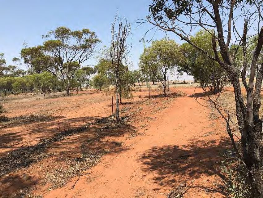
There is also a large portion of land, north of Salmon Gum Way and west of Slater Street which is reserved for
Recreation under the Local Planning Scheme. The Shire have constructed a Gazebo in this area for resting.
This is a popular recreational and walking route. It has been identified as a Local Route in the long term,
however, would be suitable to be formalised and recognised as a recreational trail.
W1219429 // 20/04/20 // Issue: B
Goomalling Bike Plan, 2020 to 2030 26OPPORTUNITIES
5.2. Volumes and Speed of Streets
The streets through the Town have relatively low volumes, but with reasonably moderate to high speed limits.
The low volumes support the opportunity for on-street cycling in a “every street is a cycle street” format.
However, this would need to be supported by a reduced speed limit. The Shire could investigate the feasibility
of a blanket speed reduction through the Town Centre. This would require signposting and on-road
treatments to slow driver behaviour.
These streets could then support safe cycling connectivity through cyclists and cars sharing the road space,
rather than the need to provide designated off road or protected on-road cycling infrastructure
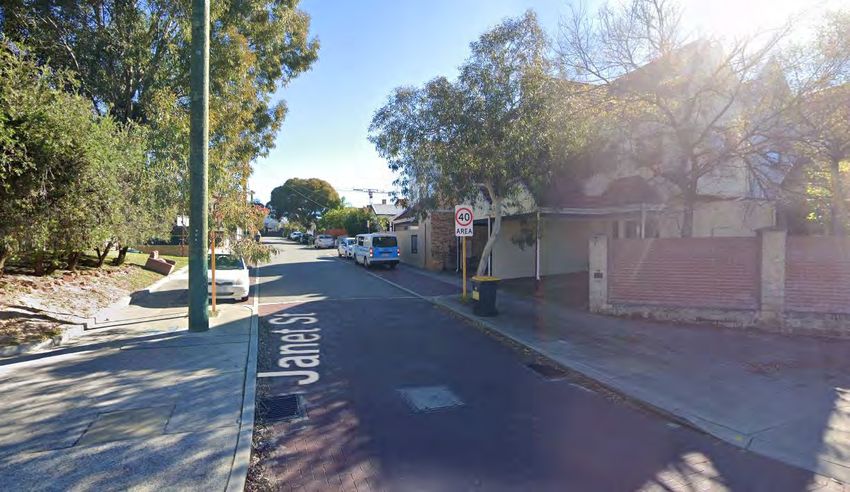
The City of Vincent is currently undertaking a two-year trial of a speed reduction to 40km/h through its
southern suburbs. The purpose of this trial is to demonstrate safer, more welcoming streets where people are
more likely to ride and walk and kids feel safe playing outdoors. The trial ends in April 2021, and analysis of
the results will help determine whether this is an appropriate long-term concept to introduce to the Town.
Figure 5.2: 40km/h Trial – City of Vincent
Source: Google Maps
5.3. Wide Street Treatments
The Town’s wide streets can be a deterrent to on-street cycling, as it may induce speeding. Three main
streets are considered to be set in a wide road reserve including Railway Terrace, Quinlan Street and Forrest
Street. As such, these roads provide the opportunity for protected bike lanes. These are discussed further in
Section 9.3.2.
Hoddy Street has been identified as a good opportunity for a Safe Active Street, given it provides access to
key attractors for vulnerable road users, including Goomalling Primary School, Sacred Heart School and the
Recreation Hub. Safe Active Streets are discussed in Section 9.3.1.
W1219429 // 20/04/20 // Issue: B
Goomalling Bike Plan, 2020 to 2030 27OPPORTUNITIES
5.4. Recreation Hub
The Recreation Hub Master Plan identified that Quinlan Street would be closed between Lockyer and Hoddy
Streets. This has been reflected in this bike plan. It is proposed that filtered permeability is applied, which is
where cyclists and pedestrians may still travel along this road, with it being closed to motor vehicles. Filtered
Permeability is discussed further in Section 9.3.4.
Figure 5.3: Examples of Filtered Permeability
Source: Cycle Highways Source: Haringey Cycling
5.5. Schools
Paths around schools should be wider, with a desirable width of 2.5m 1, to accommodate pedestrians and
cyclists. Whilst there is a good network of paths in the vicinity of the school, there is a lack of connections to
the path on the western side of Hoddy Street. Ramps are not provided and therefore inhibit crossing
opportunities or encourage children to either mount the kerb or utilise neighbouring crossovers. This presents
the opportunity to complete the missing gaps in the network through the construction of ramps to connect
the network.
5.6. Network Repairs and Upgrades
The existing cycling network would benefit from being upgraded and repaired. As discussed in Sections 4.3
and 4.4, the current quality of the path network is poor. The path is lifted, cracked, broken or damaged which
poses a hazard for users. Repairing the damaged sections of the path network would instantly enhance the
experience. The paths are also narrow. Austroads Guide to Road Design Part 6A: Pedestrian and Cyclist
Paths recommends a 1.8m path and requires a minimum of 1.5m for pedestrian paths to allow two
wheelchairs to pass.
However, as a minimum, shared path width is 2.0m in accordance with Austroads Guide to Road Design Part
6A: Pedestrian and Cyclist Paths and 2.5m in accordance with the Department of Transport’s Draft Shared
Path Guidelines. Given that the Department of Transport’s Draft Shared Path Guidelines are a local State
Government Guide, it is recommended that all shared paths are a minimum 2.5m wide. For Secondary
Routes, where there is higher patronage such as along routes to schools, a 2.5m to 3m wide shared path is
recommended. Shared Paths that are currently less than 2.5m wide are recommended to be increased as
upgrades are undertaken, or for new sections, subject to achieving the required offsets from trees, light poles
etc.
1
Austroads (2009) Guide to Road Design – Part 6A: Pedestrian and Cyclist Paths
W1219429 // 20/04/20 // Issue: B
Goomalling Bike Plan, 2020 to 2030 28OPPORTUNITIES
5.7. Funding Opportunities (Programs)
5.7.1. WABN Regional Bicycle Network Grants
The WABN grants program is one of the key actions detailed in the Western Australian Bicycle Network Plan
2014-2031. Funding is available to local government authorities in WA, for up to 50 per cent of the total
project cost, for the design and implementation of bicycle network infrastructure and programs in accordance
with State Government priorities set out in the WABN Plan.
The WABN Grant Applications are anticipated to open annually in July, where local governments are invited
to submit an Expression of Interest for grant funding. Following the Expression of Interest process, applicants
of shortlisted projects will be invited to submit a full proposal.
5.7.2. Roads to Recovery
The Roads to Recovery Program is a federal government program which supports the maintenance of the
nation's local road infrastructure asset. This program sets out to reduce fatalities and serious injuries in
crashes on Australia’s regional roads. Pedestrian and cycling facilities associated with a road can also be
funded as part of this grant, to improve the safety of vulnerable road users. Funding is allocated for each
financial year.
5.7.3. Regional Economic Development Grants
The Regional Economic Development Grants Program is a $28.8m, five-year, State Government initiative to
stimulate economic growth and development. Applications for grants are open at the start of the financial
year, with details provided on the Wheatbelt Development Commission’s website. Previous projects that have
been successful in attaining the grants include the construction of a river crossing along the Turquoise Way
Path between Jurien Bay and Cervantes, boosting sports tourism.
5.7.4. Metropolitan Regional Road Group (MRRG) Rehabilitation and Improvement
Programs
There are two MRRG grants, one for Rehabilitation and one for Improvement. These programs are primarily
focussed on the road network. However, the potential to assist cycling as part of any project should not be
overlooked in order to enhance the overall network. The construction of protected on-road bike lanes may be
included as part of a design. Submissions are received annually.
W1219429 // 20/04/20 // Issue: B
Goomalling Bike Plan, 2020 to 2030 29INITIAL CONSULTATION
6. INITIAL CONSULTATION
To understand the local community’s needs and desires for the cycling network in Goomalling, a
questionnaire survey was undertaken for a minimum period of two weeks between 24 January 2020 to 9
February 2020. The survey was available online, as well as hard copies at the Shire. The survey included 16
questions revolving around user types, routes and purposes. A total of 20 results were received with
respondents from a variety of age groups including under 15 and up to 60 years of age. Respondents
included a mix of those who cycle and those who do not. The full survey responses are included at Appendix
A.
The survey identified the main barriers to cycling being a lack of dedicated cycling infrastructure (24%), that it
was unsafe (24%) and that the weather conditions were too hot (20.7%). Other barriers noted were a lack of
access to a bike (10.3%), the terrain is too hilly (3.4%), other modes of transport are more convenient (3.4%)
and a lack of end of trip facilities available (3.4%). Access was also noted as a barrier, with gravel roads and
calthrop noted to be an issue as well as a lack of direct access between the outer parts of the Shire and inner
town centre.
It was noted that many of the respondents (88.9%) walked more often than they rode their bike. The majority
of respondents rode their bikes less frequently, with 30% of respondents cycling occasionally (a few days a
month) and 30% cycling rarely (a few times a year). 10% of respondents cycled every day, whilst 20% of
respondents cycled 2 to 6 days a week and 5% of respondents cycled 1 to 2 days a week. Half of those who
cycled, cycled with their children whilst 45% of respondents cycled alone. 20% of respondents cycled with
the friends or partner, respectively and 5% cycled with their parents and 5% with their sibling(s). 50% of
respondents were comfortable riding on the road, whilst 15% of total responses would consider riding on the
road if it were safer to do so.
18 respondents provided 40 responses with regards to their time of travel. Respondents could select multiple
options and it was noted that the most popular time for cycling was between 3pm to 6pm followed by 6pm to
dusk with 66.7% of respondents noting that they cycle between 3 to 6pm, and 50% of respondents cycling
between 6pm and dusk. Other common times were 7.30am to 9am and 9am to 11am with 33.3% and 22.2%
respectively.
The purpose of trips were primarily for fitness and health or fun, with 80% of respondents identifying these
are key motivations. 45% of respondents also identified riding to shops, cafes or restaurants as a purpose.
This identifies the need for recreational routes, but also commuting routes linking to the main commercial
strip along Railway Terrace.
The main attractions were the café/restaurants, oval, Goomalling sporting complex, swimming pool,
Goomalling Primary School, playground, Goomalling Memorial Hall, the pump park and Gumnuts Childcare
Centre.
The top six routes utilised include:
1. Quinlan Street 4. Hoddy Street
2. Railway Terrace 5. Forrest Street
3. Throssell Street 6. Goomalling-Toodyay Road.
Other key routes include:
W1219429 // 20/04/20 // Issue: B
Goomalling Bike Plan, 2020 to 2030 30You can also read