LYNN WALKING AND BICYCLING NETWORK PLAN 2019 - CITY OF LYNN, MA - February 2019 - Community ...
←
→
Page content transcription
If your browser does not render page correctly, please read the page content below
Lynn
      Walking
 and Bicycling
Network Plan

                    CITY OF LYNN, MA

                    LYNN WALKING AND
                 BICYCLING NETWORK PLAN
                          2019

                           February 2019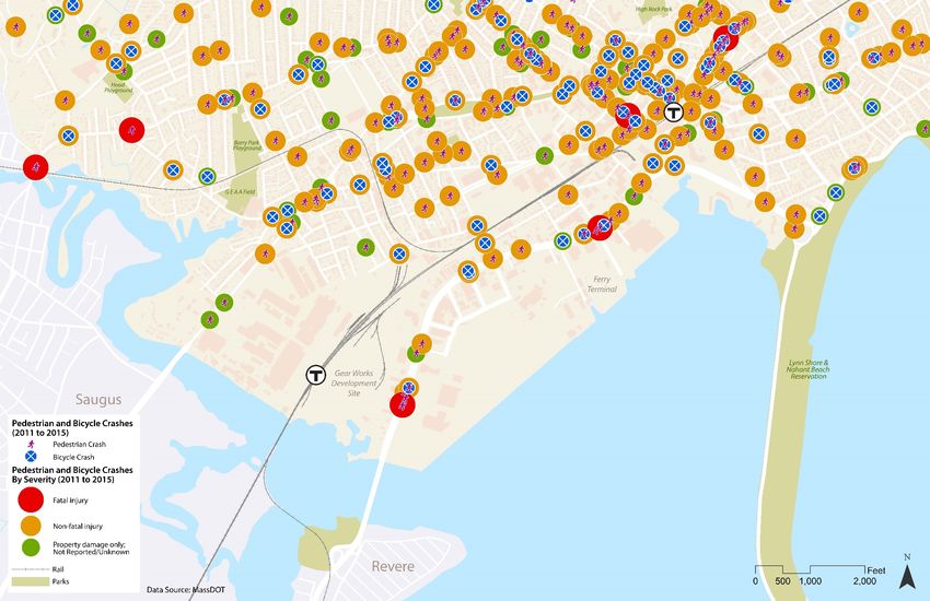
Conceptual Network Plan and Feasibility Study

Lynn Walking and Bicycling Network
Plan

Lynn, Massachusetts

Final

February 2019
Conceptual Network Plan and Feasibility Study

Lynn Walking and Bicycling Network Plan

Lynn, Massachusetts

Prepared For:
City of Lynn – Office of Community Development
3 City Hall Square
Room 311, City Hall
Lynn, MA. 01901
718/586/6770

Prepared By:
Kittelson & Associates, Inc.
294 Washington Street, Suite 11
Boston, MA 02108
(617) 377-4000

Project Manager: Tess Stribos
Project Principal: Conor Semler

Project No. 22576.00

February 2019
Lynn Walking and Bicycling Network Plan                                                                                                                                         Executive Summary
February 2018

TABLE OF CONTENTS
Executive Summary ................................................................................................................................ 2
The Challenge ....................................................................................................................................... 4

   Project Introduction .................................................................................................................................................................... 4

   Project Description and Goals ..................................................................................................................................................... 4

   Project Scope and Study Area ..................................................................................................................................................... 4
Engaging The Community ...................................................................................................................... 9

   Community Workshops ............................................................................................................................................................... 9

   Stakeholder Meetings ................................................................................................................................................................. 9

   Online Platforms........................................................................................................................................................................ 10
Building “Informed-Consensus”........................................................................................................... 12

   Existing Conditions .................................................................................................................................................................... 12

   Workshop #1 Objectives............................................................................................................................................................ 22

   Workshop #1 Outcomes ............................................................................................................................................................ 26
Developing The Vision.......................................................................................................................... 30

   Tiered Criteria for Route Alignment .......................................................................................................................................... 30

   Workshop #2 Objectives............................................................................................................................................................ 31

   Workshop #2 Outcomes ............................................................................................................................................................ 31
Implementing The Plan ........................................................................................................................ 49

   Implementation Strategy .......................................................................................................................................................... 49

   Short-Term Implementation Strategy ....................................................................................................................................... 49

   Conceptual Cost Estimates ........................................................................................................................................................ 52

   Funding ...................................................................................................................................................................................... 53
Conclusion                  ..................................................................................................................................... 56

                                                                                          III                                                                         Kittelson & Associates, Inc.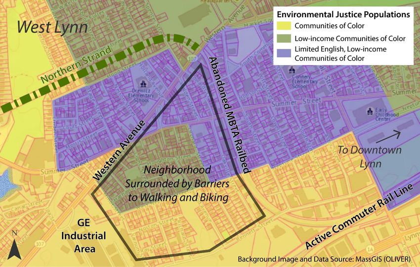
Lynn Walking and Bicycling Network Plan                                                                                                  Executive Summary
February 2018

LIST OF FIGURES
Figure 1. The Preferred Route of the Northern Strand in Lynn ............................................................. 2
Figure 2. Planning Processes at Multiple Levels .................................................................................... 5
Figure 3. Network Plan Study Area ........................................................................................................ 6
Figure 4. Annual Average Daily Traffic Volumes .................................................................................. 14
Figure 5. Existing and Proposed Walking and Biking Facilities ............................................................ 16
Figure 6. Pedestrian and Bicycle Crashes and Severity........................................................................ 17
Figure 7. Percentage of Population that are Youth or Seniors ............................................................ 18
Figure 8. Percentage of Households with No Vehicle.......................................................................... 19
Figure 9. Percentage of Workers Who Walk or Bicycle to Work ......................................................... 20
Figure 10. Environmental Justice Populations ..................................................................................... 21
Figure 11. Directional Arrows for Guidance of Route Alternatives ..................................................... 24
Figure 12. Route Options Developed During Workshop #1................................................................. 27
Figure 13. EJ Neighborhoods Surrounded by Barriers to Walking and Biking ..................................... 32
Figure 14. Alternative #1 - Common/Lynnway .................................................................................... 33
Figure 15. Alternative #2 - Common/Nahant ...................................................................................... 33
Figure 16. Alternative #3 - Summer/Lynnway ..................................................................................... 34
Figure 17. Alternative #4 - Summer/Nahant ....................................................................................... 34
Figure 18. Alternative #5 - Neptune/Lynnway..................................................................................... 35
Figure 19. Alternative #6 - Neptune/Nahant ....................................................................................... 35
Figure 20. Recommended Alternative ................................................................................................. 37
Figure 21. Typical Section Example for Summer Street – Sidepath/Shared Use Path ........................ 39
Figure 22. Typical Section Example for Neptune Street Court – Traffic Calmed Bike Boulevard ........ 40
Figure 23. Typical Section Example for Neptune Boulevard - Road Diet with Shared Use Path ......... 40
Figure 24. Typical Section Example for State Street (Long-Term) and Commercial Street - Two-Way
Separated Bike Lane............................................................................................................................. 41
Figure 25. Typical Section Example for Blossom Street (Long-Term) - Two-Way Separated Bike Lane41
Figure 26. Typical Section Example for Central Avenue and Washington Street - Two-Way Separated
Bike Lane       ..................................................................................................................................... 41
Figure 27. Typical Section Example for Broad Street (Long-Term) - Two-Way Separated Bike Lane.. 42
Figure 28. Typical Section Example for Nahant Street – Traffic Calmed Bike Boulevard .................... 42

                                                                       IV                                                        Kittelson & Associates, Inc.
Lynn Walking and Bicycling Network Plan                                                                                           Executive Summary
February 2018

Figure 29. Relationship between Speed, Traffic Volume, and Facility Type ........................................ 43
Figure 30. Bike Facility Types ............................................................................................................... 44
Figure 31. Raised Driveway Crossing ................................................................................................... 45
Figure 32. Raised Side Street Crossing ................................................................................................. 45
Figure 33. Curb Extension .................................................................................................................... 46
Figure 34. Protected Intersection ........................................................................................................ 46
Figure 35. Raised Crosswalk (Midblock) .............................................................................................. 47
Figure 36. Rectangular Rapid Flash Beacon (RRFB) ............................................................................. 47

LIST OF TABLES
Table 1. Route Evaluation Criteria ....................................................................................................... 28
Table 2. Tiered Route Evaluation Criteria ............................................................................................ 30
Table 3. Route Evaluation Results ........................................................................................................ 36
Table 4. Planning-Level Construction Cost Estimate .......................................................................... 52

APPENDICES
Appendix 1. Conceptual Plan

Appendix 2. Conceptual Cross Sections and Renderings

Appendix 3. Technical Memo: Route Alternatives Elimination

Appendix 4. Public Engagement Materials

                                                                   V                                                       Kittelson & Associates, Inc.
Section 1 Executive Summary

Lynn Walking and Bicycling Network Plan                                                         Executive Summary
February 2018

EXECUTIVE SUMMARY

In recent years, major planning efforts have taken place around Lynn. The City of Lynn (the City) is building
on this regional momentum by proactively planning for investment with the Lynn Walking and Bicycling
Network Plan (Network Plan) and aligning regional and local planning efforts. At the community
workshops for the Network Plan community members voiced concern that resources and destinations
within and around the city are difficult to reach or are even considered cut off for residents. The
development of the Northern Strand Community Path is an opportunity for Lynn to create safer and more
connected walking and bicycling options in the city to address these issues. Lynn is uniquely positioned
as the destination of the regional bicycling facility. This 10-mile Northern Strand, when completed, will
connect the cities of Everett, Malden, Revere, Saugus, and Lynn to the Lynn Shore and Nahant Beach
Reservation. At the same time in Lynn, nearly a decade of work by the Community Path of Lynn Coalition
has brought a local, grassroots vision to the table for the abandoned MBTA railbed in Lynn.

The Lynn Walking and Bicycling Network Plan builds on these regional and local planning efforts to
leverage State investment and align local and regional initiatives to achieve the greatest benefit for Lynn
residents, community organizations, business owners, and other local stakeholders in the city of Lynn.
The Network Plan is the resulting product stemming from a planning process based around multi-day
public workshops held in Lynn. It contains a planning-level feasibility study for the Preferred Route
Alternative of the Northern Strand as it transitions from an off-street facility at Western Avenue onto the
public roads in Lynn. The Preferred Route Alternative splits at Western Avenue into a Main Route and a
Local Spur. The latter continuing along the abandoned MBTA railbed to connect the local neighborhoods
to the regional Northern Strand with a path (see Figure 1). The Main Route consists of a continuous,
branded bike facility, including the improvement of pedestrian facilities, new intersection and mid-block
crossing locations, and appropriate traffic calming measures

Figure 1. The Preferred Route of the Northern Strand in Lynn

                                                 2                                       Kittelson & Associates, Inc.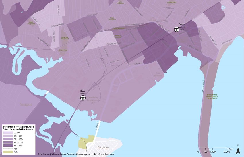
Section 2 The Challenge
Lynn Walking and Bicycling Network Plan                                                             The Challenge
February 2018

THE CHALLENGE

PROJECT INTRODUCTION
The Massachusetts Executive Office of Energy and Environmental Affairs (EEA) is developing the Northern
Strand Community Trail, running from Medford to Saugus and crossing multiple communities on its way.
This 10-mile shared use path run on an old railbed on (former) Massachusetts Bay Transportation
Authority (MBTA) right-of-way. However, partway through the City of Lynn, the railbed is cut-off by the
active MBTA Commuter Rail line – just short of the Northern Strand’s envisioned terminus at the Lynn
Shore and Nahant Beach Reservation. While in other cities, the planned path has a dedicated space,
completing the 10-mile long facility requires making choices about what route it will take on Lynn city
streets. The City of Lynn is therefore taking this opportunity to position Lynn as a destination on this
regional route, transforming the shared use path into an equitable resource that activates shops,
residential neighborhoods, and public amenities: through the Lynn Walking and Bicycling Network Plan
(Network Plan).

PROJECT DESCRIPTION AND GOALS
The Network Plan was prepared in accordance with the City’s request for both a network plan for
bicyclists and pedestrians and a feasibility study for a regional shared use facility. The main goal of the
Network Plan is to identify the most feasible route for the Northern Strand through Lynn.

As such, the Network Plan consists of three elements:

     •    An assessment of alternative routes for the Northern Strand from Western Avenue to
          the Lynn Shore and Nahant Beach Reservation;
     •    A planning-level feasibility study of the recommended alternative for the Northern
          Strand; and
     •    A consideration of secondary routes to connect to/from the Northern Strand and
          future waterfront development

The planning-level considerations are limited to the following factors: right-of-way (ROW), land and
roadway ownership, stakeholders, engineering evaluation, feedback from the public, and additional
research done by the project team to determine the feasibility in line with the level and scope of the
Network Plan. In all this, the planning process was steered by the public feedback received throughout
the process.

PROJECT SCOPE AND STUDY AREA
The Network Plan is municipal planning process by the City of Lynn that both responds to and proactively
creates a ‘blueprint’ as the City engages with planning processes occurring at multiple levels, as shown in
Figure 2. The Northern Strand is a regional shared use path project implemented by EEA through its

                                                4                                      Kittelson & Associates, Inc.
Lynn Walking and Bicycling Network Plan The Challenge
February 2018
Gateway Cities Parks Program. At the neighborhood level, the Community Path of Lynn Coalition (CPLC)
has been working for multiple years leading up to the Network Plan on the local section of the Northern
Strand through Lynn, primarily focusing on the abandoned MBTA-owned railbed in City of Lynn’s Ward
Six in West Lynn.
Figure 2. Planning Processes at Multiple Levels
While the Network Plan is a municipal plan, it focuses on the core area of the city as a starting point for
building a more walkable, bikeable Lynn by leveraging the Northern Strand as a major initial investment
in a longer-term vision. Figure 3. shows the Network Plan Study area, from west of Western Ave at the
current and temporary terminus of the Northern Strand to the Lynn Shore Reservation and Nahant Beach.
The study area includes downtown Lynn, focusing on the Market Street corridor, and part of the West
Lynn neighborhood surrounding the abandoned MBTA railbed.
5 Kittelson & Associates, Inc.Lynn Walking and Bicycling Network Plan The Challenge
February 2018
Figure 3. Network Plan Study Area
6 Kittelson & Associates, Inc.Lynn Walking and Bicycling Network Plan The Challenge
February 2018
The Network Plan is one of a series of planning processes that the City of Lynn has undertaken in
collaboration with regional and state partners over the past decade, including:
Northern Strand Community Path Design (2018 and ongoing by Brown,
Richardson + Rowe for the EEA)
Lynn Waterfront Open Space Master Plan (2018 and ongoing by Brown,
Richardson + Rowe for the City of Lynn)
Lynn Gear Works Redevelopment Final Environmental Impact Report (2017 by
VHB for Lynnway Associates, LLC for EEA)
Route 1A/Lynnway/Carroll Parkway Study in Lynn (2016 by the Boston Region
Metropolitan Planning Organization)
Northern Strand Trail Communities Bicycle and Pedestrian Network Plan (2013 by
the Metropolitan Area Planning Council)
Market Street Gateway Plan (2009 by VHB for the City of Lynn)
Lynn Waterfront Master Plan (2007 by Sasaki for the City of Lynn)
These plans underscore the evolving nature of Lynn as it welcomes new development and envisions
connections to and from its downtown and waterfront assets.
The Network Plan kicked off in June 2018, with a six-month planning process resulting in a set of
conceptual plans and this report, which documents the planning process and provides recommendations
to bring the Network Plan from a conceptual ‘blueprint’ to a fully-realized infrastructure investment.
Following this planning process, the plan will be used by EEA and Brown, Richardson + Rowe to design
this final link of the Northern Strand through Lynn as part of their ongoing design process occurring in
multiple Northern Strand communities.
7 Kittelson & Associates, Inc.Section 3 Engaging the Community
Lynn Walking and Bicycling Network Plan Engaging The Community
February 2018
ENGAGING THE COMMUNITY
This project’s planning process was set up so that the two major phases of identifying the Northern Strand
route alternatives and selecting the preferred alternative occurred during two intensive community
workshops. These workshops were supplemented with stakeholder meetings and the use of online
platforms to gather additional feedback. The community engagement efforts consisted of the following:
COMMUNITY WORKSHOPS
The two three-day public workshops were the base of the planning process for the Network Plan and are
detailed in the next sections. These included:
Workshop #1 – Tuesday, August 21st through Thursday, August 23rd, 2018 at the
Lynn Vocational Technical Institute
Workshop #2 – Tuesday, November 13th through Thursday, November 15th, 2018
at the Lynn City Hall Auditorium
Each workshop generally ran from the morning to 8 pm, with public drop-in hours during the afternoons
and evenings. For the flyers, schedules and other materials for the workshops and other public
engagement efforts see Appendix 4.
STAKEHOLDER MEETINGS
The project team attended several meetings with the Network Plan’s Working Group, which includes
public, private and non-profit organizations such as:
City of Lynn Community Development and Public Works departments and
Mayor’s Office
City of Lynn Fire and Police departments
Economic Development & Industrial Corporation of Lynn (EDIC)
Lynn Housing and Authority and Neighborhood Development
Community Path of Lynn Coalition
The Food Project
Hall Company
The project team also coordinated with Brown, Richardson + Rowe to facilitate a streamlined transition
from the Northern Strand conceptual design to the final design to be created by Brown, Richardson +
Rowe.
9 Kittelson & Associates, Inc.Lynn Walking and Bicycling Network Plan Engaging The Community
February 2018
ONLINE PLATFORMS
To gather additional feedback and share plan materials with those unable to attend the Community
Workshops, the project team maintained:
A dedicated website for the project (www.lynnbikeped.com)
An interactive webmap for collecting feedback during each project phase
(maps.kittelson.com/lynn), with 57 unique comments were collected throughout
the planning process, with 127 “like” interactions associated with 44 of the
comments
A social media page on Facebook (www.facebook.com/Lynn-Walking-and-
Bicycling-Plan-669370730062455/) that has reached a thousand people since
June 2018, according to Facebook-provided statistics
For more details on these three platforms see Appendix 4.
10 Kittelson & Associates, Inc.Section 4 Building “Informed-Consensus”
Lynn Walking and Bicycling Network Plan Building “Informed-Consensus”
February 2018
BUILDING “INFORMED-CONSENSUS”
EXISTING CONDITIONS
Roadway Facilities
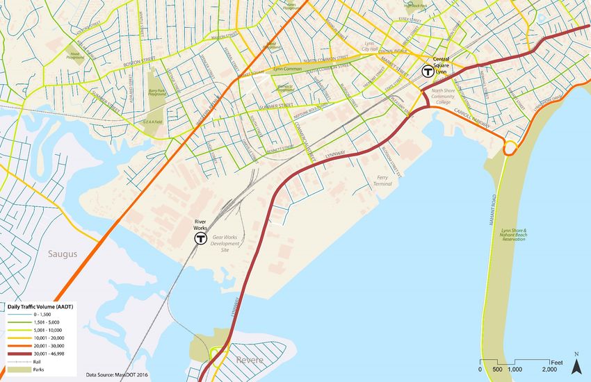
Traffic volume data provide the following information:
Whether a roadway is operating under-capacity and may have room to replace
travel lanes with bike lanes or is operating at capacity, thus requiring a trade-off
between automobile level of service and bike quality of service if seeking to install
on-street bike facilities
Whether traffic volumes create high-stress conditions for bicycling, therefore
necessitating the use of separated facilities to create low-stress routes that can
serve users of all ages and abilities. Typically, a two-lane, 25 mph road with no
bike facilities will begin to feel high-stress to a mainstream rider above 1,500
vehicles per day. 1 Higher traffic volumes require greater levels of separation.
As shown in Figure 4, most streets that provide direct more connections between Western Avenue and
the Lynn Shore & Nahant Beach Reservation have traffic volumes that require separated facilities to feel
comfortable for the average person on a bike. Neighborhood residential streets tend to be low-stress,
but they require crossing high-stress roads and making a circuitous route.
The project team identified the following information using the most recent available traffic volume data
from MassDOT (2016):
South Common Street has much lower traffic volumes than North Common
Street, but it has the same cross section (layout of travel and parking lanes).
Neptune Boulevard is operating under-capacity, with very low volumes compared
to the amount of road space available.
Market Street should be subject to more detailed traffic analysis to determine
whether it is operating under or at capacity. Vehicles use sections of the road as
a four-lane cross section when it is not officially marked as such.
1
Furth, Peter. 2017. Level of Traffic Stress Criteria for Road Segments, version 2.0.
12 Kittelson & Associates, Inc.Lynn Walking and Bicycling Network Plan Building “Informed-Consensus”
February 2018
Lynnway/Carroll Parkway traffic volumes decline by approximately 10,000
vehicles per day on the section east of Market Street, since Market Street is a
major entrance/exit point for vehicles on the Lynnway.
13 Kittelson & Associates, Inc.Lynn Walking and Bicycling Network Plan Building “Informed-Consensus”
February 2018
Figure 4. Annual Average Daily Traffic Volumes
14 Kittelson & Associates, Inc.Lynn Walking and Bicycling Network Plan Building “Informed-Consensus”
February 2018
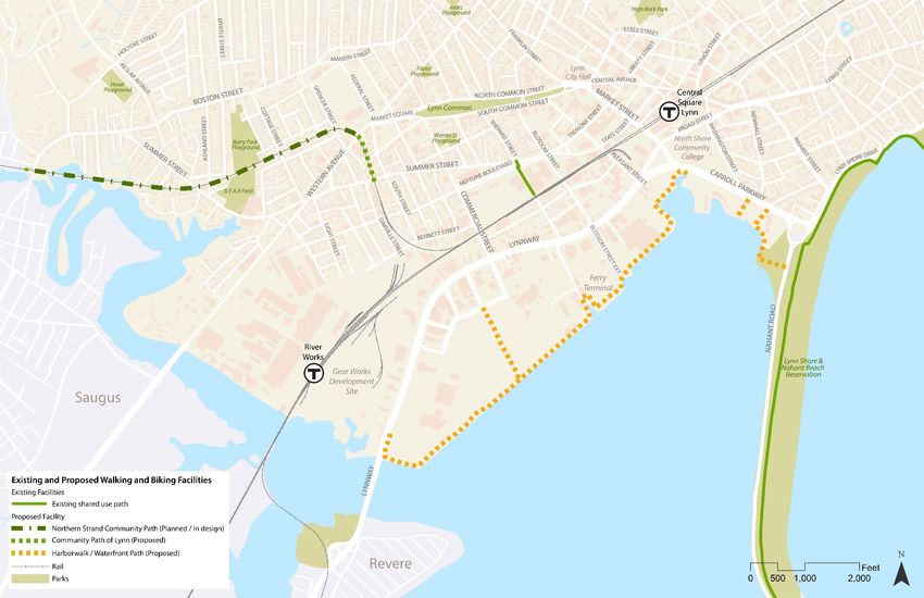
Pedestrian and Bike Facilities
Though the City of Lynn has good sidewalk coverage in the core area and has walking routes in its historic
linear park, the Lynn Common, bicycle facilities are lacking throughout the city, and pedestrian crossing
challenges exist, particularly at large and busy intersections along the Lynnway/Carroll Parkway. Figure 5
shows existing and proposed pedestrian and bicycle facilities. Planned facilities include:
Short-term: The section of the Northern Strand from Saugus to Western Avenue
that is currently in the EEA’s Northern Strand Community Path design process
Long-term: A Harborwalk that would be built as the Lynn waterfront is
redeveloped; this proposed facility is currently in the planning phase as part of
the Lynn Waterfront Open Space Master Plan (Draft).
Crashes
Figure 6 shows MassDOT-recorded crash locations from 2011 through 2015 where a person walking or
biking was involved, along with crash severity. The majority of crashes led to injury, with fatalities within
the study area located on the Lynnway and on Market Street.
Transit Facilities
Lynn is served by several MBTA transit services, including the Rockport/Newburyport commuter rail line
and nine MBTA bus routes. 2 The Central Square-Lynn MBTA commuter rail station is elevated above
Washington Street and Central Square and serves as hub along with a public parking garage/Park & Ride
and busway east of Market Street. MBTA bus routes 426, 429, 435, 436, 439, 441, 442, 448, 449, 455,
456, and 459 serve downtown Lynn via either South Common Street, Lynnway, Franklin Street, and Union
Street. Additionally, Route 439 to Nahant runs along Washington Street and Nahant Street and Route
435 serving Neptune Towers runs along Tremont Street, Summer Street, and Neptune Boulevard.
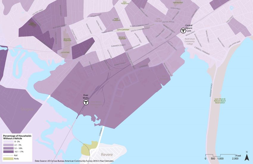
Transportation Users
Demographic data from the US Census Bureau 2016 American Community Survey (ACS) Five-Year
Estimates shed light on the opportunity to better serve youth and seniors (Figure 7), households without
a vehicle (Figure 8), and workers commuting by foot or bicycle (Figure 9), with bicycle and pedestrian
facilities in the residential areas where they are concentrated and connecting them to everyday
destinations.
2
MBTA System Map. https://cdn.mbta.com/sites/default/files/maps/2018-04-map-system.pdf
15 Kittelson & Associates, Inc.Lynn Walking and Bicycling Network Plan Building “Informed-Consensus”
February 2018
Figure 5. Existing and Proposed Walking and Biking Facilities
16 Kittelson & Associates, Inc.Lynn Walking and Bicycling Network Plan Building “Informed-Consensus”
February 2018
Figure 6. Pedestrian and Bicycle Crashes and Severity
17 Kittelson & Associates, Inc.Lynn Walking and Bicycling Network Plan Building “Informed-Consensus”
February 2018
Figure 7. Percentage of Population that are Youth or Seniors
18 Kittelson & Associates, Inc.Lynn Walking and Bicycling Network Plan Building “Informed-Consensus”
February 2018
Figure 8. Percentage of Households with No Vehicle
19 Kittelson & Associates, Inc.Lynn Walking and Bicycling Network Plan Building “Informed-Consensus”
February 2018
Figure 9. Percentage of Workers Who Walk or Bicycle to Work
20 Kittelson & Associates, Inc.Lynn Walking and Bicycling Network Plan Building “Informed-Consensus”
February 2018
Environmental Justice Communities
In any planning process, it is important to examine where communities that have historically been
underserved or even harmed by infrastructure investments live. Environmental Justice (EJ) seeks to
ensure that low-income residents and communities of color have meaningful participation in decision-
making processes, are not disproportionately affected by potential negative impacts, and benefit fairly
from projects and programs. In Massachusetts, EJ communities are defined as any census block group
where:
Annual median household income is equal to or less than 65% of the statewide
median; or
25% or more of the residents identify as minority (non-white races as well as
Hispanic ethnicity including White Hispanic); or
25% or more of households have no one over the age of 14 who speaks English
only or English very well – Limited English Proficiency (LEP)/English Isolation
Most of the core area of Lynn is classified as an EJ area, with several neighborhoods meeting multiple EJ
criteria, as shown in Figure 10. Nearly the entire Network Plan study area is home to low-income
communities of color, with three pockets of more concentrated linguistic isolation.
Figure 10. Environmental Justice Populations
Source: MassGIS OLIVER
21 Kittelson & Associates, Inc.Lynn Walking and Bicycling Network Plan Building “Informed-Consensus”
February 2018
WORKSHOP #1 OBJECTIVES
Workshop #1 was an opportunity for the project team to engage in fact-finding about route alternatives
and for the Lynn residents and other stakeholders to begin the process of building an ‘informed
consensus’ on the Northern Strand route. This process began with the founding of goals and principles
intended to guide the study after this workshop:
Goals and Principles
Using information and feedback gained from local stakeholders and workshop participants, the project
team developed a series of goals and principles to guide the identification and evaluation of route
alternatives. These goals and principles also functioned as an over-arching framework to inform the route
evaluation criteria at a high level. They included:
Connect the Community Path – The Community Path, as envisioned by grassroots
efforts, represents an important local investment as vocalized by the attendees
and is critical to the overall resident and stakeholder acceptance of the Network
Plan
Connect to the Water – The City is currently working toward a waterfront open
space master plan as well as bringing more development focus towards the
marina.
Bring People Downtown – Downtown Lynn is the heart of the City; Leveraging the
Northern Strand to to boost the activity in the downtown core project is critical.
Focus on Multimodal Safety – As more bicyclists and pedestrians are encouraged,
the more focus must be paid to providing facilities that are safe, comfortable, and
accessible to all types of users.
Balance User Needs with Context – Streets change as they move through different
neighborhoods, and different parts of the City. The multimodal facilities also need
to adapt and conform to their respective contexts.
Prioritize the Network – While there is a primary path for the Northern Strand to
travel through Lynn, the remaining streets and neighborhood connectors need to
be prioritized and considered for implementation over time to complete a wide-
breadth of walkable and bikeable streets in the City.
Route Alternatives
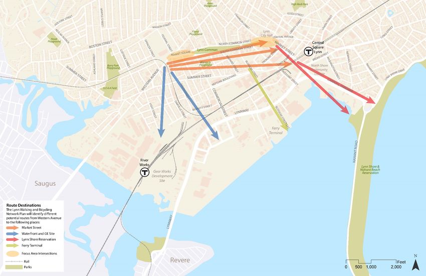
The identification of route alternatives during Workshop #1 was guided by the following considerations,
visualized in Figure 11:
Starting from the temporary terminus of the Northern Strand at Western Avenue,
connect to the following destinations:
22 Kittelson & Associates, Inc.Lynn Walking and Bicycling Network Plan Building “Informed-Consensus”
February 2018
Lynn Shore & Nahant Beach Reservation
Downtown Lynn
Ferry Terminal
Future waterfront development and Gear Works development
Identify streets that could be part of a hierarchy of primary and secondary routes
in the Network Plan
Identify preliminary ideas for focus area intersections including Market Square
and North Common Street / South Common Street / Franklin Street / Essex Street
/ Central Avenue / Market Street
23 Kittelson & Associates, Inc.Lynn Walking and Bicycling Network Plan Building “Informed-Consensus”
February 2018
Figure 11. Directional Arrows for Guidance of Route Alternatives
24 Kittelson & Associates, Inc.Lynn Walking and Bicycling Network Plan Building “Informed-Consensus”
February 2018
Public Interaction and Feedback
As a 3-day public event, Workshop #1 gave stakeholders an opportunity to participate in the planning
process through a variety of activities, including:
Origin and destination dot-mapping for a variety of trip purposes
String-mapping of walking, biking, and driving routes through Lynn
Walking and biking audit to identify issues and opportunities
Working Group meeting for city officials and working group members to discuss
goals and concerns and to align local efforts
Image 1. Workshop #1 Activities
25 Kittelson & Associates, Inc.Lynn Walking and Bicycling Network Plan Building “Informed-Consensus”
February 2018
WORKSHOP #1 OUTCOMES
By the end of Workshop #1, the project team identified several options and variations for the Northern
Strand to gather initial reactions before formalizing the route alternatives during Workshop #2.
Route Options
Figure 12 shows all the route options explored during Workshop #1. They were organized according two
major functions:
Community Path options create local connections in West Lynn and include future
connections to the waterfront area near the Gear Works development, the future
Harborwalk, and the Ferry Terminal. These options would require one or more of
the following:
New crossing where the abandoned MBTA railbed approaches the active
MBTA commuter rail line
Bike facility on the City of Lynn Department of Public Works (DPW)
access road
Bike facility on Commercial Street and Gas Wharf Road
Bike facility on Oakville Street, Bennett Street, and extension of Harding
Street
Bike facility on Summer Street or Neptune Street Court
Permission to travel adjacent to the GE Aviation plant to River Works
MBTA station
Regional Facility options partially overlap with Community Path options and
extend the Northern Strand to the downtown, the Ferry Terminal, and the Lynn
Shore and Nahant Beach Reservation. These options would require one or more
of the following:
Bike facility on South Common Street or inside the Lynn Common
Bike facility on Summer Street or Neptune Street Court
Bike facility on Neptune Boulevard and Wheeler Street/State Street
Bike facility on Blossom Street and new intersection across the Lynnway
Bike facility on Market Street or Washington Street
Bike facility on the Lynnway or land south of the Lynnway and around
Nahant Rotary
As the project team received feedback, these options were filtered and refined to a smaller set for
soliciting feedback on the interactive webmap from September to November.
26 Kittelson & Associates, Inc.Lynn Walking and Bicycling Network Plan Building “Informed-Consensus”
February 2018
Figure 12. Route Options Developed During Workshop #1
Route Evaluation Criteria
Table 1 details the route evaluation criteria that were developed in draft form at the end of Workshop
#1 and refined during the time leading up to Workshop #2.
27 Kittelson & Associates, Inc.Lynn Walking and Bicycling Network Plan Building “Informed-Consensus”
February 2018
Table 1. Route Evaluation Criteria
Category Criterion Scoring and Measurement
1 point - High (State involvement)
Level of Interagency Coordination Required 2 points - Medium (Local, with multiple departments, institutions, and businesses)
3 points - Low (Local, primarily with neighborhoods)
Engineering Effort (based in need to redesign
major intersections, perform traffic analysis, 1 point - High complexity
consider impacts to curb, drainage, and 2 points - Medium complexity
utilities, and consider impacts to MBTA bus 3 points - Low complexity
Feasibility operations)
1 point - High cost (high-level planning estimate)
Cost 2 points - Medium cost (high-level planning estimate)
3 points - Low cost (high-level planning estimate)
1 point - Long (High interagency + High engineering effort)
2 points - Medium-term (Medium interagency + Medium engineering effort or high/low
Timeline
combinations)
3 points - Short (Low interagency + low engineering effort)
1 point - Low (Provides access to lower-density residential land uses)
2 points - Medium (Provides access to commercial and medium-density residential land uses)
Accessibility to Destinations
3 points - High (Provides access to commercial, mixed use, institutional, and/or high-density
residential land uses)
0 points - No (Focuses investment on existing roads)
Reuse of Abandoned Railbed
Placemaking 1 point - Yes (Leverages opportunity to transform abandoned corridor into new public space)
and Environmental Justice Impact (Based on
Revitalization 1 point - Low (0 to 1,999 weighted-population counts receiving access)
population in census block groups adjacent to
2 points - Medium (2,000 to 5,999) weighted-population counts receiving access)
route segment, weighted by number of EJ
3 points - High (6,000+ weighted-population counts receiving access)
criteria met, using data from MassGIS)
1 point - Low (Route is circuitous and requires intensive wayfinding measures)
Route Continuity 2 points - Medium (Route has a few turns requiring wayfinding measures)
3 points - High (Route provides direct connections)
Public Feedback (Received throughout
1 point - Not favored
Public process, but especially on cross-section
2 points - Somewhat favored or mixed
Feedback boards presented during Workshop #2 and
3 points - Consistently favored
interactive webmap)
28 Kittelson & Associates, Inc.Section 5 Developing the Vision
Lynn Walking and Bicycling Network Plan Developing The Vision
January 2018
DEVELOPING THE VISION
Coming out of Workshop #1, the project team had a set of preliminary route options, feedback about
those, and a set of evaluation criteria by which to further evaluate a more final set of route alternatives.
During the time between Workshop #1 and #2, the project team also gathered information about specific
issues, such as safety and adjacent land ownership. This information led to the elimination of several
route alternatives (see Appendix 3) and the addition and refinement of other alternatives, as reflected
in updates to the interactive webmap leading up to Workshop #2.
TIERED CRITERIA FOR ROUTE ALIGNMENT
Leading up to and during Workshop #2, four overarching needs emerged from public feedback,
stakeholder feedback, and deeper assessment of the route options. These led to the creation of two tiers
of criteria summarized in Table 2:
Tier I Criteria were used to determine where the multiple route alternatives could
be located given spatial constraints and major challenges from Western Avenue
to the Lynn Shore and Nahant Beach Reservation
Tier II Criteria were used to compare the alternatives against each other to
determine the recommended route.
Table 2. Tiered Route Evaluation Criteria
Tier I Criteria: Potential Route Locations Tier II Criteria: Selection of Preferred Route
• No removal of on-street parking: Received • Feasibility
consistent and repeated feedback that removal of o Interagency Coordination
on-street parking would not be received well in o Engineering Effort
both residential and commercial areas o Planning and Construction Costs
o Timeline
• Branded, recognizable regional facility: The • Placemaking and Revitalization
preferred route must be appropriate for facility o Accessibility to Destinations
that is open 24/7 and connects Lynn to o Reuse of Abandoned Railbed
surrounding cities, with a mix of local, commuting, o Environmental Justice Impact
and recreational trip-making by Lynn residents and o Route Continuity
visitors to Lynn
• Two-way separated bike facility for on-street • Public Feedback
sections: Allows for efficiency of space and DPW
maintenance (existing 8’ – 10’ snow plow)
• Avoid active MBTA rail lines: For reasons of
feasibility, timeline, and safety
30 Kittelson & Associates, Inc.Lynn Walking and Bicycling Network Plan Developing The Vision
January 2018
WORKSHOP #2 OBJECTIVES
Workshop #2 was an opportunity for the project team to gather feedback on route alternatives and
design ideas and for the Lynn community to consolidate an ‘informed consensus’ on the Northern Strand
route through Lynn.
WORKSHOP #2 OUTCOMES
Alternatives
A final set of six (6) route alternatives emerged based on the Tier I and Tier II criteria. The major choices
were between the South Common Street, Summer Street, and Neptune Street for the first section and
between the Lynnway/Carroll Parkway and Nahant Street for the last section. All route alternatives travel
on Market Street for one or more blocks. In addition, all route alternatives include a local spur of the
Northern Strand.
Inclusion of Abandoned Railbed Spur in All Alternatives
The common element in each route alternative is the inclusion of the abandoned MBTA railbed from
Western Avenue to Bennett Street as a spur of the Northern Strand. This spur is included in all route
alternatives to allow local access to the main Northern Strand route from the neighborhood southeast of
Western Avenue and west of the abandoned MBTA railbed. As shown in Figure 13, one area of West Lynn
is home to residents facing both environmental justice challenges and physical barriers to walking and
biking connectivity and accessibility:
1. The active commuter rail line to the south
2. The GE industrial area to the west
3. Western Avenue to the north—a high-stress roadway due to traffic volumes, speeds
and limited number of signalized crossing locations
4. The abandoned MBTA railbed to the east—currently a barrier because its changing
grade, single access point at Summer Street, and condition of abandonment and
perceived public safety issues
This access is important, because it is the only area in Lynn with over 1,000 residents who face barriers
to safe walking and biking on all four sides.
31 Kittelson & Associates, Inc.Lynn Walking and Bicycling Network Plan Developing The Vision
January 2018
Figure 13. EJ Neighborhoods Surrounded by Barriers to Walking and Biking
While some of the alternative routes presented in the following pages use part of the abandoned
railbed as the main route, others include it as a spur:
For Alternatives #1 and #2, this off-street section functions as a spur of the
Northern Strand to facilitate local access.
For Alternatives #3 through #6, it functions partially as the main Northern Strand
route and partially as a spur for local access and placemaking.
The route alternatives evaluation accounted for whether it would function as the main Northern Strand
route or the local spur.
The final set of six (6) route alternatives are shown in Figures 14-19.
32 Kittelson & Associates, Inc.Lynn Walking and Bicycling Network Plan Developing The Vision
January 2018
Six Route Alternatives Meeting Tier 1 Criteria
Figure 14. Alternative #1 - Common/Lynnway
Figure 15. Alternative #2 - Common/Nahant
33 Kittelson & Associates, Inc.Lynn Walking and Bicycling Network Plan Developing The Vision
January 2018
Figure 16. Alternative #3 - Summer/Lynnway
Figure 17. Alternative #4 - Summer/Nahant
34 Kittelson & Associates, Inc.Lynn Walking and Bicycling Network Plan Developing The Vision
January 2018
Figure 18. Alternative #5 - Neptune/Lynnway
Figure 19. Alternative #6 - Neptune/Nahant
Alternatives Evaluation Using Tier II Criteria
The route alternatives were evaluated as follows:
Routes were divided into segments based on roadway or corridor character and
constraints
35 Kittelson & Associates, Inc.Lynn Walking and Bicycling Network Plan Developing The Vision
January 2018
The abandoned railbed, as a common element of all route alternatives,
was not included as a segment except where it would serve as the main
Northern Strand route instead of a spur.
Each segment was scored with all criteria except route-level criteria
Segment scores were averaged across the entire route (A sensitivity analysis using
sum of segment scores instead of average scores was conducted, leading to
similar results)
Route-level criteria were assessed for each route (Reuse Abandoned Railbed,
Route Continuity, and Public Feedback)
The score was summed across criteria.
Table 3. Route Evaluation Results
Note: IC = Interagency Coordination, E = Engineering Effort, C = Cost, T = Timeline, AD = Accessibility to Destinations, R =
Reuse of Abandoned Railbed, EJ = Environmental Justice Impact, RC = Route Continuity, P = Public Feedback
As shown in Table 3, Alternative #1 (Common/Lynnway) had the highest score. The range of difference
between scores was small, since there were many overlapping segments. Also, the drivers of high scores
varied across each route segment, leading to an averaging out at the route level.
The scores also reflect the different functions that a shared use path can have within a community based
on its location and purpose. A regional facility is a branded, continuous path that spurs economic
development and puts Lynn’s “best face forward.” A local facility connects neighborhoods outwards,
connects residents to local institutions, and allows children to bike safely to school. As a regional shared
use path, the main Northern Strand has the former function. The secondary bike network can serve the
latter function, but a local spur of the Northern Strand is needed where connectivity is limited in West
Lynn.
36 Kittelson & Associates, Inc.Lynn Walking and Bicycling Network Plan Developing The Vision
January 2018
Recommended Alternative
The recommended alternative consists of:
A main route that travels north on Western Avenue, through Market Square, on
South Common Street, Market Street, crossing the Lynnway/Carroll Parkway and
heading east on the south side of the Lynnway/Carroll Parkway to an existing
crosswalk across Nahant Road. A continuous two-way separated bike facility, at
level with the roadway, typically 10-feet wide and including a 3-foot raised buffer
is recommended throughout the alignment of the preferred alternative. In a few
select areas, the facility transitions into a sidewalk-level shared use path where
repurposing road space was not desired.
A local spur along the abandoned MBTA railbed.
See Appendix 1 for the conceptual plan drawings and Appendix 2 for conceptual cross sections and
renderings for select segments.
Figure 20. Recommended Alternative
Main Route – Segment Description
Western Avenue: Two-way separated bike facility transitions to sidewalk at
roundabout, using the broad shoulder on Western Avenue and repurposing parts
of the landscaped area of the roundabout.
Market Square: Transition from sidewalk to two-way separated bike facility on
the south side.
37 Kittelson & Associates, Inc.Lynn Walking and Bicycling Network Plan Developing The Vision
January 2018
South Common Street: Two-way separated bike facility on the south side,
repurposing one of two through lanes and moving on-street parking away from
the sidewalk. The bike facility is separated by the on-street parking and a 3-foot
raised buffer.
Market Street from South Common Street to Tremont Street/Liberty Street:
Transition from street to sidepath on the west side (sidewalk level), transition
back to street level at Tremont Street. This segment resulted from a compromise
in terms of the continuity of the facility in order to keep all current on-street
parking between 1 Market Street and 65 Market Street (10-15 spaces).
Market Street from Tremont Street/Liberty Street to State Street: Two-way
separated bike facility on the west side, narrowing the existing through lane width
and keeping on-street parking, but moving it away from the sidewalk.
Market Street from State Street to Broad Street: Two-way separated bike facility
on the west side, keeping on-street parking, but moving it away from the
sidewalk. Planted medians and left-turn pockets respectively organize the space.
Market Street from Broad Street to Lynnway/Carroll Parkway: Transition from
street to intermediate-level two-way separated bike facility on the west side (in
Carroll Parkway green space), transition back to street level at the
Lynnway/Carroll Parkway.
Lynnway/Carroll Parkway: Two-way separated bike facility on the south side at
street level, repurposing one of three existing through lanes.
Nahant Rotary: Two-way separated bike facility on the east side at street level,
repurposing one through lane.
Nahant Road: Transition from street to sidepath on the west side, and wayfinding
signs to connect to Lynn Shore Promenade and the East Coast Greenway.
Local Spur - Community Path Description
Western Avenue: Neighborhood gateway with raised intersection, pedestrian
crossing beacon, and wayfinding signs
Western Avenue to Neptune Street Court: Shared use path through abandoned
MBTA railbed right-of-way.
Summer Street Crossing: Raised intersection, pedestrian crossing beacon (RRFB),
and wayfinding signs
Neptune Street Court: Open lawn area showcasing existing mural and grading to
transition to Neptune Street Court access point and secondary bike facility along
Neptune Street
38 Kittelson & Associates, Inc.Lynn Walking and Bicycling Network Plan Developing The Vision
January 2018
Neptune Street Court to remainder of abandoned MBTA railbed right-of-way:
Pedestrian park with options for placemaking elements such as community
gardens and local artist installations, as well as open spaces for viewsheds, and
eventually community access to areas like the Gearworks Site and other areas
beyond Bennett Street especially if the existing bridge crossing over Bennett
Street could be rebuilt to provide safer access.
Toolkit (Future Installments by the City)
Secondary Network
The secondary network consists of on-street routes that provide important connections to the Northern
Strand, downtown Lynn, and future waterfront development. These initial streets include Summer Street,
Neptune Street Court, Neptune Boulevard, State Street, Commercial Street, Central Street, Washington
Street, and Nahant Street, shown in Figure 20 to 27.
Figure 21. Typical Section Example for Summer Street – Sidepath/Shared Use Path
39 Kittelson & Associates, Inc.Lynn Walking and Bicycling Network Plan Developing The Vision
January 2018
Figure 22. Typical Section Example for Neptune Street Court – Traffic Calmed Bike Boulevard
Figure 23. Typical Section Example for Neptune Boulevard - Road Diet with Shared Use Path
40 Kittelson & Associates, Inc.Lynn Walking and Bicycling Network Plan Developing The Vision
January 2018
Figure 24. Typical Section Example for State Street (Long-Term) and Commercial Street - Two-Way
Separated Bike Lane
Figure 25. Typical Section Example for Blossom Street (Long-Term) - Two-Way Separated Bike Lane
Figure 26. Typical Section Example for Central Avenue and Washington Street - Two-Way Separated Bike
Lane
41 Kittelson & Associates, Inc.Lynn Walking and Bicycling Network Plan Developing The Vision
January 2018
Figure 27. Typical Section Example for Broad Street (Long-Term) - Two-Way Separated Bike Lane
Figure 28. Typical Section Example for Nahant Street – Traffic Calmed Bike Boulevard
As the City of Lynn becomes a more bike and pedestrian friendly environment, other connections will be
desired, especially from neighborhoods to the north of Lynn Common and east of Downtown Lynn. In the
future, a more comprehensive network, including a wayfinding strategy, should be planned as part of
Bicycle and Pedestrian Master Plan for the entire City of Lynn.
42 Kittelson & Associates, Inc.Lynn Walking and Bicycling Network Plan Developing The Vision
January 2018
Typical Street Conditions
Beyond the conceptual designs for the Northern Strand and the series of secondary network streets, the
Network Plan also examined general guidance for facility types and treatments that can be applied for all
remaining City streets both existing and future.
Bike Facility Types
As speed of vehicles or traffic volumes increase, the level of separation necessary for safe and
comfortable biking increases, as illustrated in Figure 29. Since City of Lynn’s speed limit is set at 25 mph
unless otherwise posted, a “sharrow” is not an appropriate facility for most streets in Lynn unless
combined with traffic calming elements such as regularly placed speed humps and curb extensions.
Figure 29. Relationship between Speed, Traffic Volume, and Facility Type
43 Kittelson & Associates, Inc.Lynn Walking and Bicycling Network Plan Developing The Vision
January 2018
Figure 30 shows common bike facility types ranging in level of separation from a shared lane to a fully
separated bike lane or shared use path. The facility type should be selected based on the street’s traffic
volume and operating speed to provide the level of comfort necessary for riders of all ages and abilities
to feel safe using the facility.
Figure 30. Bike Facility Types
Intersection Treatments
Raised crossings make streets safer by reducing the speed of turning vehicles while increasing the
visibility of pedestrians and bicyclists. They are recommended for crossings at major driveways (Figure
31) and at minor streets or side streets (Figure 32). See the MassDOT Separated Bike Lane Planning &
Design Guide for more information.
44 Kittelson & Associates, Inc.Lynn Walking and Bicycling Network Plan Developing The Vision
January 2018
Figure 31. Raised Driveway Crossing
Source: MassDOT Separated Bike Lane Planning & Design Guide
Figure 32. Raised Side Street Crossing
Source: MassDOT Separated Bike Lane Planning & Design Guide
45 Kittelson & Associates, Inc.Lynn Walking and Bicycling Network Plan Developing The Vision
January 2018
Curb extensions installed at intersections increase the visibility of pedestrians and reduce crossing
distance (Figure 33). They also reduce the corner radius, thus slowing turning speeds of motorists. Curb
extensions can be combined with stormwater management features that absorb rainwater and reduce
flooding.
Figure 33. Curb Extension
Source: NACTO Urban Street Design Guide
At major intersections with intersecting separated bike lanes, a protected intersection treatment (Figure
34) reduces conflicts between modes and provides a clear, predictable path of travel. Treatment
elements consist of a corner refuge island, pedestrian crossing islands, and where necessary, a mountable
truck apron.
Figure 34. Protected Intersection
Source: MassDOT Separated Bike Lane Planning & Design Guide
46 Kittelson & Associates, Inc.Lynn Walking and Bicycling Network Plan Developing The Vision
January 2018
Pedestrian Crossing Treatments
Raised crosswalks (Figure 35) can be used both at intersections and at midblock locations. Midblock
crosswalks should be installed where a significant (or anticipated) pedestrian desire line causes people
to cross where a marked crossing does not exist, often at key access points to destinations.
Figure 35. Raised Crosswalk (Midblock)
Source: NACTO Urban Street Design Guide
Pedestrian crossing beacons such as pedestrian hybrid beacons (PHB, previously referred to as HAWKs)
or Rectangular Rapid Flash Beacons (RRFBs) should be installed at unsignalized locations that are high-
volume pedestrian crossings or high-priority bike route crossings. These user-actuated beacons allow
bicyclists and pedestrians to alert drivers that they are crossing. RRFBs (Figure 36) tend to be much
lower-cost than PHBs.
Figure 36. Rectangular Rapid Flash Beacon (RRFB)
Source: NACTO Urban Bikeway Design Guide
47 Kittelson & Associates, Inc.You can also read