FOUR CORNERS/ BLM CORRIDOR MASTER PLAN - CITY OF COEUR D'ALENE - Bureau of Land ...
←
→
Page content transcription
If your browser does not render page correctly, please read the page content below
WC_cmyk.tif
        WC_cmyk.ai

                 CITY OF COEUR D’ALENE
FOUR CORNERS/BLM CORRIDOR MASTER PLAN
Acknowledgements
City Council                                        ignite CDA Board
Mayor Steve Widmyer                                 Chairman Denny Davis
Council Members:                                    Board Commissioners:
Dan Gookin                                                    Dave Patzer
Amy Evans                                                     Rob Colwell
Loren R. Edinger                                              Justin Druffel
Kiki Miller                                                   Steve Widmyer
Steve Adams                                                   Brad Jordan
Woody McEvers                                                 Deanna Goodlander
Renata McLeod, City Clerk                                     Scott Hoskins
                                                              Mic Armon
                                                    Tony Berns, Executive Director

Steering Committee
Mayor Widmyer
Council Member Evans
Scott Cranston, Parks and Recreation Commission Chairman
Dave Patzer, ignite CDA and Parks and Recreation Commission
Steve Anthony, City of Coeur d’Alene
Bill Greenwood, City of Coeur d’Alene
Tony Berns, ignite CDA Executive Director
Mark Browning, North Idaho College
Janna Paronto, Bureau of Land Management
Michael Teague, Community Member

Consultant Team
Welch Comer Engineers                       Miler Stauffer
Phil Boyd, P.E.                             Dick Stauffer, AIA
Adam Dorsey, P.E.                           Mike Walker, NCARB
Chris Bosley, P.E.
Dell Hatch, ASLA
Melissa Cleveland, P.E.
Sandra Sonnen
Lina Turner

Four Corners/BLM Expansion Master Plan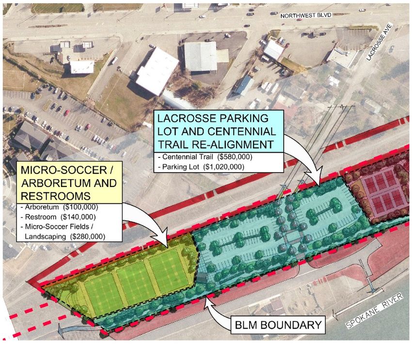
Executive Summary
The City of Coeur d’Alene (City) has an opportunity to establish a long-term lease with the
Bureau of Land Management (BLM) for 29 acres of abandoned railroad corridor that can
connect, in a primarily non-motorized manner, popular public and private land uses. The BLM
requires the City to submit a proposed “Plan of Development” detailing the proposed land uses
within the corridor. The City’s Four Corners area located at the southern end of the BLM
property has been a City focused redevelopment area for the existing public facilities and uses.
The City decided to combine the BLM Plan of Development with the Four Corners planning
area into a single Four Corners/BLM Corridor Master Planning effort. The purpose of this effort
is to satisfy BLM requirements and establish a long range plan of action for the BLM Land and
the Four Corners area.
The City’s primary objectives for the master plan included:

    •   Engaging the community in the process to ensure the master planned improvements
        reflect the community’s vision and values.
    •   Developing land uses and improvements within the BLM Corridor that will satisfy the
        BLM criteria for a recreational purposes lease.
    •   Updating the previous Four Corners Concept Plan to address recent changes to the
        City’s street network and current community desired Four Corners uses.
    •   Developing an actionable funding and implementation plan, realizing the long
        implementation time frame.
The public engagement process was developed in a manner to allow groups and individuals
multiple opportunities and avenues to provide input through public and small group meetings,
the City website, and email and written correspondence. Mayor Widmyer appointed a steering
committee to guide the process to ensure continuity with City policy, community vision and
previous City planning efforts. More than 40 meetings were conducted that generated over
200 comments and the website generated another 100 comments.
The result of these efforts is a master plan that reflects the community’s desired uses and
improvements for the Four Corners Area and the BLM Corridor (that satisfy the BLM criteria for
a recreational purposes lease). The proposed uses will help the City meet the recreational
needs of a growing population by adding new recreational opportunities and supplementing
overburdened existing facilities. The proposed uses will also create a highly desirable non-
motorized link between special public and private existing and future land uses.
The City succeeded in conducting an open and inclusive public engagement process to
develop uses that reflect the community’s desires and worked diligently to balance the
occasional competing public desired use for specific planning areas. The City intends to
continue working toward satisfying the BLM Lease requirements and implementing the master
plan improvements.

Four Corners/BLM Corridor Master Plan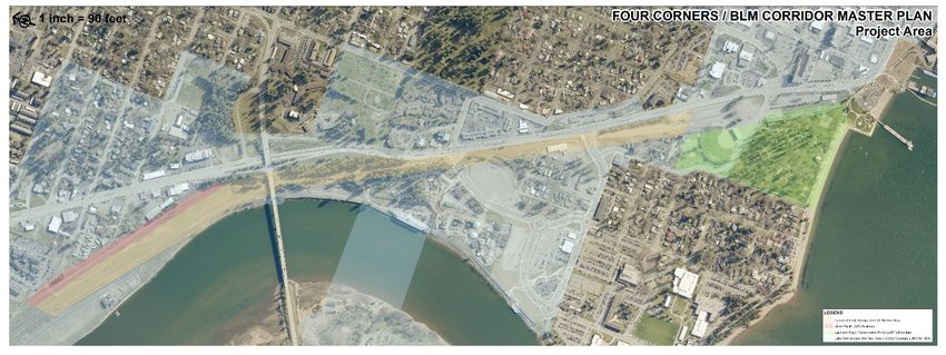
TABLE OF CONTENTS
Chapter 1 Intoduction ....................................................................................................................1
  Background ................................................................................................................................1
     Project Purpose .......................................................................................................................4
     Planning Areas ........................................................................................................................4
     Community Vision ....................................................................................................................6
          Four Corners-Community Vision .........................................................................................6
          BLM Land-Community Vision .............................................................................................6
     Planning Process .....................................................................................................................7
          Public Input.........................................................................................................................7
          Analysis ..............................................................................................................................10
Chapter 2 Concept Development ....................................................................................................11
  Preliminary Concepts ..................................................................................................................11
     Community Dialogue ...............................................................................................................12
     Final Concepts .........................................................................................................................14
          1 Independence Point, City Parking Lot & Waterfront Promenade ........................................15
          2 Memorial Field & Mullan Road .........................................................................................16
          3 Active Recreation Park ....................................................................................................17
          4 River Ave. to Hubbard Ave. Transition Zone ......................................................................18
          5A Hubbard Ave. to Harbor Center ......................................................................................19
          5B Harbor Center to US -95 ...............................................................................................20
          6A US-95 to Lacrosse Park ................................................................................................21
          6B Lacrosse Park to Western End .......................................................................................22
Chapter 3 Development and Improvement Plan ..............................................................................23
  Proposed Improvements .............................................................................................................23
     Management Plan ...................................................................................................................23
          1 Independence Point, City Parking Lot & Waterfront Promenade ........................................24
          2 Memorial Field & Mullan Road .........................................................................................25
          3 Active Recreation Park ....................................................................................................26
          4 River Ave. to Hubbard Ave. Transition Zone ......................................................................27
          5A Hubbard Ave. to Harbor Center ......................................................................................28

Four Corners/BLM Corridor Master Plan                                                                                              Table of Contents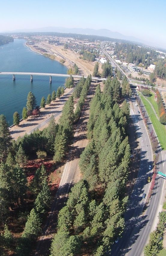
5B Harbor Center to US -95 ...............................................................................................29
         6A US-95 to Lacrosse Park ................................................................................................30
         6B Lacrosse Park to Western End .......................................................................................31
Chapter 4 Implementation Plan ......................................................................................................32

Four Corners/BLM Corridor Master Plan                                                                                  Table of Contents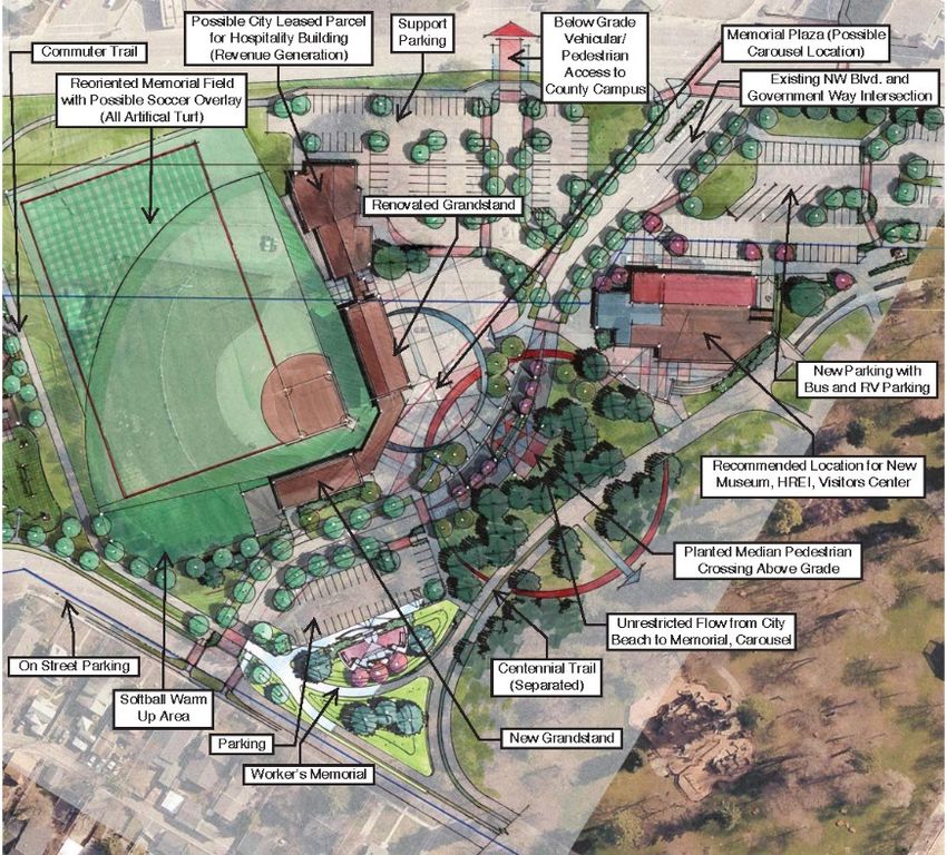
TABLE OF FIGURES

Figure 1 A historic view of the planning areas. ............................................................................................ 2
Figure 2 A mixed used commercial/residential development) segment (which included the portion reverting to the
Bureau of Land Management (BLM)), creating a continuous public land link between several significant public and
private land uses ........................................................................................................................................ 3
Figure 3 In 2015, the City in partnership with Ignite CDA (formerly Lake City Development Corporation), purchased
the remaining BNSF ROW from Riverstone west to the City limits at Huetter Road expanding these linkages
 .................................................................................................................................................................. 4
Figure 4 Four Corners Planning Sub Areas. ................................................................................................. 5
Figure 5 BLM Corridor Planning Sub Areas. ................................................................................................ 5
Figure 6 Mullan Road/Government Way & Northwest Boulevard Create the "Four Corners"......................... 6
Figure 7 The Forested Area in this Photo is Primarily BLM Corridor ............................................................. 6
Figure 8 Excerpt from BLM Survey.............................................................................................................. 6
Figure 9 Planning Process Graphic Presentation ......................................................................................... 7
Figure 10 Example of Maps Used on Steering Committee Walk Tour........................................................... 9
Figure 11 Graphical Representation of the Analysis Criteria and Process..................................................... 9
Figure 12 Mullan Road's Five Lane Configuration Is No Longer Necessary for Current Traffic Demands ...... 10
Figure 13 Early Planning Sub-Area Graph with Planning Elements ............................................................. 11
Figure 14 Four Corners Early Concept Plan Presented Broad Planning Concepts for the Steering Committee such as
“Should Mullan Road be Closed or Remain Open. ....................................................................................... 11
Figure 15 Harbor Center Early Concept Plan Demonstrating the “wide open” Outdoor Recreation Potential of the
BLM Corridor .............................................................................................................................................. 11
Figure 16 Study Zones................................................................................................................................ 12
Figure 17 Early Sketches were intentionally “loose” in Order to demonstrate there are no Pre-conceived Set in
Stone Ideas. ............................................................................................................................................... 12
Figure 18 Big Picture Questions Presented at Public Workshop #1. ............................................................. 13
Figure 19 Concept Boards Were Used at Individual Stations to Allow Team Members to Interact and Directly
Discuss with Community Members the Thoughts behind the Concepts and Solicit their Input ..................... 14

Four Corners/BLM Corridor Master Plan                                                                                                          Table of Figures
APPENDICES

Appendix A:     Legal Description
Appendix B:     Public Comments
Appendix C:     Workshop #1 Public Comments
Appendix D:     Workshop #1 Website Comments
Appendix E:     Workshop #2 Public Comments
Appendix F:     Workshop #2 Website Comments

Four Corners/BLM Corridor Master Plan                Appendices
Chapter 1 Introduction
Background
The City of Coeur d’Alene (City) has long recognized the community value of acquiring the Burlington
Northern Santa Fe Railroad (BNSF) right of way (ROW) within the City. In 2005, the City facilitated the
ROW abandonment from Mullan Road to the east terminus at the Coeur d’Alene Resort Golf Course.
This abandonment allowed the popular downtown City Library to be constructed. In 2011, the City
facilitated abandonment of Mullan Road west to Riverstone (a mixed used commercial/residential
development) segment (which included the portion reverting to the Bureau of Land Management (BLM)),
creating a continuous public land link between several significant public and private land uses (See
Figure 2). In 2015 the City, in partnership with Ignite CDA (formerly Lake City Development Corporation),
purchased the remaining BNSF ROW from Riverstone west to the City limits at Huetter Road expanding
these linkages (See Figure 3).

After the 2011 BNSF ROW
abandonment, the City initiated
an effort to exchange a parcel
of City-owned land for the
BNSF ROW that had reverted
to the BLM (BLM Parcel, See
Appendix A for legal
description). Ultimately, the
exchange did not reach fruition
primarily because the City-
offered land would create a
long term BLM operation
expense. The City then
applied for a BLM Parcel lease,
which triggered the need for a          Figure 1 A historic view of the planning areas.
BLM required Plan of
Development. Recognizing the
BLM Plan of Development
presented a significant community input opportunity, the City expanded the Plan of Development limits
to include the entire 2011 BNSF ROW abandoned segment from the intersection of Mullan Road and
NW Boulevard (Four Corners) north to Riverstone and named the effort the “Four Corners/BLM Corridor
Master Plan.”

Four Corners/BLM Corridor Master Plan                                                             Page 1
Project Purpose
    The purpose of the Four Corners/BLM Corridor Master Plan (Master Plan) is summarized in four parts:

          1. Conduct extensive community outreach to solicit ideas, present options, and develop a
             community driven master plan.

          2. Identify and conceptually develop community desired uses for the BLM Corridor that will satisfy
             the BLM criteria for a recreational purposes lease.

          3. Update the previous Four Corners Concept plan to address current community desired Four
             Corners uses that will be compatible with and complement the BLM parcel uses and the recently
             completed $19 Million McEuen Park project.

          4. Develop an actionable funding and implementation plan based on opinions of cost for the
             proposed improvements.

    The Master Plan will be used by the BLM to evaluate the proposed uses for compliance with BLM
    regulations and by the City to efficiently complete proposed improvements over a 10 to 15 year
    development time. The long development period requires a Master Plan to ensure a continuity of
    development

                                                                  Planning Areas
                                                                  The Master Plan includes two “planning areas”
A Growing Community                                               defined by geographic location and land
                                                                  ownership; the “Four Corners” area and the “BLM
                                                                  Corridor.” These two areas are further divided into
The planning areas are located in the southwest corner of         sub-areas based on proposed functional use.
the City (population 44,137) which is the largest City in North
Idaho and considered the regional center for commerce,            Four Corners
health care, arts, entertainment and recreation. The City’s
population increased an estimated 8.6% between 2010 and           Four Corners is located at the intersection of
2014, exceeding the state’s growth rate of 2.9% for the           Northwest Boulevard and Government Way
same period (US Census Bureau). Coeur d’Alene is bordered         (East)/Mullan Road (West) and is surrounded by
by Lake Coeur d’Alene to the south, the Spokane River to the
                                                                  City Beach and Park, Independence Point, the Fort
west and south, the Bitterroot Mountains to the east, and
neighboring towns of Dalton Gardens (population 2,335) and        Grounds Neighborhood and the Kootenai County
Hayden (population 12,294) to the north and Post Falls            Courthouse Campus. It includes the following
(population 27,574) to the west.                                  planning sub-areas with land ownership in
                                                                  parenthesis (see Figure 4):
While the City’s residential and commercial growth slowed
during the recession, the City is currently experiencing a        1. Independence Point/City Park Parking Lot (City)
strong residential growth recovery, particularly with multi-
family housing within 1.5 miles of the corridor’s west end.       2. Memorial Field/Mullan Road (City)
The nearby multi-family housing will create a high demand
for non-motorized connections to public and commercial
areas and increase the demand for outdoor recreation areas.

    Four Corners/BLM Corridor Master Plan                                                                      Page 4
BLM Corridor
The BLM Corridor extends from the
Garden Avenue ROW northwest
approximately one mile to
Riverstone and includes the
following sub-areas with land
ownership in parenthesis.
3. Active Recreation Park (BLM,
City, Ignite CDA)
4. River Ave to Hubbard Ave
(BLM)
5. Dog Park, Bike Park and
Outdoor Classroom (BLM), and
Harbor Center Marina (City)
6. LaCrosse Park (BLM)
Figure 4 Four Corners Planning Sub Areas.
The BLM Corridor is bordered by
the “Education Corridor” (a
collaborative college/university campus including North Idaho College, University of Idaho and Lewis
Clark State College), the Spokane River, Bellerive Neighborhood and Riverstone.
Figure 5 BLM Corridor Planning Sub Areas.
All of the planning areas are adjacent to the City’s primary western entrance and transportation corridor,
Northwest Boulevard. The Four Corners/BLM Corridor land is an extremely high value land asset
because it provides outstanding opportunities to create critical non-motorized linkages between
existing, and developing, popular public and private land uses and it provides the opportunity for
expanded outdoor recreation. The Four Corners/BLM Corridor Master Plan land will become key
features in the City’s urban fabric.
Four Corners/BLM Corridor Master Plan Page 5Community Vision
The community vision for the Four Corners/BLM
Corridor is derived from the planning process
outlined in this report and previous City planning
and visioning efforts including the City
Comprehensive Plan, 2006 Parks Master Plan,
2005 Four Corners Study, 2011 Education
Corridor Master Plan and 2014 CDA 2030 Plan.
Four Corners-Community Vision
The community’s vision for the Master Plan
planning area is to better connect City Park and
Memorial Field by modifying Mullan Road (which
divides these areas) from vehicle focused to Figure 6 Mullan Road/Government Way & Northwest
pedestrian focused, adding uses currently Boulevard Create the "Four Corners".
underserved or not served at all in the City Park
system and preserving and sensitively upgrading
Memorial Field and the Spokane Railroad
Battery Building (currently occupied by the
Human Rights Education Institute (HREI))
while celebrating their historical character.
BLM Land-Community Vision
The community recognizes that the BLM
Corridor presents a special opportunity for
the community to shape the changes to a
relatively undeveloped property. The
community’s broad vision for the BLM
parcel is to take advantage of the unique Figure 7 The Forested Area in this Photo is Primarily BLM Corridor.
land characteristic and provide unique
recreational opportunities that are not currently found in the City
Park system and add underserved recreational needs. The
community’s vision for the BLM Corridor areas with mature forest
is to create outdoor recreation uses that preserve the forest and
create environmental and historical educational opportunities in
this area since it borders the Spokane River and historic sites.
In the BLM Corridor areas that were once highly developed with
railroad and lumber mill infrastructure and are now “blank slate”
areas with limited vegetation, the community vision is to reclaim
these former industrial areas and create a more structured and
highly developed outdoor recreation area.
Figure 8 Excerpt from BLM Survey.
Four Corners/BLM Corridor Master Plan Page 6Planning Process
The City’s primary objective in the planning process was to ensure the Master Plan reflected the
community values and vision, while being influenced and shaped by related previous community
planning and visioning processes (City Comprehensive Plan, 2006 Parks Master Plan, 2005 Four
Corners Study, 2011 Education Corridor Master Plan, and the 2014 CDA 2030) as well as City and BLM
policies and regulations. In order to meet this objective, the City followed the planning process
graphically presented in Figure 9.
Figure 9 Planning Process Graphic Presentation.
Public Input
In order to capture the community values and vision,
the City provided both multiple public input
opportunities and a variety of input formats. Table 1
summarizes the community input opportunity,
objective, format and general meeting outcomes:
Four Corners/BLM Corridor Master Plan Page 7Table 1 Community Input
Opportunity Objective Format Outcome
Initial Community Outreach at Public presentation of
Bulleted list of community
Parks & Recreation Hosted Publicize the project and planning areas with no
brainstorming ideas (See
Workshops June 2013 to January solicit ideas. pre-conceived ideas
Appendix B)
2014 presented.
Individual small group
Focused Small Group Meetings
Provide opportunity for meetings with broad Summary of small group
September 2014 through
“singular” issue groups to planning concepts “key points” of emphasis
November 2014 (see side bar on
provide input. presented then listening to (See Appendix C)
following page for small groups)
small group input
Present collected Ideas City staff and consultants
Short public presentation
and desires that had been received direct feedback
followed by a multi-station
organized in the planning and comment sheets
Public Workshops #1 and #2 open house where the
areas. Workshop #1 were provided for written
December 3, 2014 and February community can view
presented initial concepts. feedback. Comments and
25, 2015 concepts in details and talk
Workshop #2 presented written input provided
with designers and City
refined concepts based insight on community
staff
on public input vision and values.
Allow those that can’t Presented Preliminary
attend meetings to Concepts with “Big Idea”
Written responses to
Website Presentation with provide input and provide questions to stimulate
questions and written
Comment December 4, 2015, an opportunity for those community responses.
comments to presented
February 25, 2015 that do attend meetings Updated with each concept
concepts.
to provide additional revision with comment
input. opportunity.
Input and direction from
Parks and Recreation Commission Present concepts and commission charged with
Public committee meeting.
Meeting November 17, 2014 and community input, solicit managing City Parks and
Public comment allowed.
April 15, 2015 committee’s direction Recreation as well as
public input.
Present concepts and Broader input from City
community input, P&R leadership on topics such
Public Council Workshop.
City Council Workshop July 9, 2015 Commission comments, as impacts on adjoining
No public comment
solicit City Council land, traffic circulation,
direction funding.
Four Corners/BLM Corridor Master Plan Page 8The City also wanted to ensure that the Master Plan would be
shaped by City leadership (vision, policy and funding), City
partners from education (vision and needs), urban renewal (vision
and funding) and BLM (vision and regulations), City Staff Steering Committee Members
(institutional knowledge and continuity), and community input.
Mayor Widmyer appointed a steering committee to guide the
• Mayor Steve Widmyer
process and provide the Consultant Team with direction.
• Councilmember Amy Evans
• Scott Cranston, Parks and Recreation
In order to familiarize the Steering Committee with the Planning Commission Chairman
Areas existing conditions, using adjacencies and influencing • Dave Patzer, Ignite CDA and Parks and
elements the Consulting Team and Steering Committee completed Recreation Commission Member
a physical tour of the Planning Areas. The committee used maps • Steve Anthony, Parks and Recreation
identifying the study zones and elements to orient themselves (see Director
Figure 10). The Consultant Team also conducted numerous • Bill Greenwood, Parks and Recreation
Superintendent
meetings with “small groups.” The small groups were identified
• Tony Berns, Ignite CDA Executive Director
because of their
• Mark Browning, North Idaho College
particular focused • Janna Paronto, Bureau of Land
interest on a part Management
of the project, • Michael Teague, Community Member
Small Groups Meetings their proximity to
the planning
• Kootenai County areas, or as key partners in the project. The objective
• Fort Grounds & CDA North HOAs of meeting with the small groups was to have the
• Bellerive, Riverstone and Mill River HOAs opportunity to capture their ideas and thoughts and
• Disability Action Center discuss them in greater detail than a public meeting
• Coeur d’Alene Tribe, Idaho Department of would permit.
Lands, Army Corps of Engineers and
Idaho Department of Environmental
Quality
• Human Rights Education Institute,
Museum of North Idaho and Coeur
d’Alene Carousel Foundation
• University of Idaho and BLM
• North Idaho Centennial Trail Foundation
• Skate Park and BMX Representatives
Analysis
Using the data from the initial public outreach,
small group meetings, previous City Planning and
Visioning documents, BLM guidance and direction
from the Steering Committee, the Team initiated
the analysis effort to locate proposed uses in the
planning areas using the criteria shown in Figure
11. The results of the analysis was developed of
conceptual uses organized throughout the
planning area, which are presented in the following Figure 10 Example of Maps Used on Steering Committee Walk Tour.
chapter.
Four Corners/BLM Corridor Master Plan Page 9Traffic analysis was completed on Mullan Road to determine the impacts of narrowing or closing the
road and modifying the intersection of Park Avenue/Garden
Avenue. The Education Corridor roadway improvements at
Hubbard and River Avenues appeared to dramatically reduce the
Mullan Road traffic demand. The traffic analysis was intended to
quantify the impact.
The River Avenue connection to Northwest Boulevard has
decreased traffic on Mullan Avenue by nearly 40% for westbound
and over 50% for eastbound traffic. Today, the existing two
eastbound through lanes and the two-way left turn lane are
unnecessary for the existing traffic volumes. Reducing the
number of through lanes and removing the two-way left turn lane
has little to no impact on traffic operations.
Closing Mullan Avenue permanently or seasonally requires that Figure 11 Graphical Representation of the
traffic using Mullan Avenue for access onto or off of Northwest Analysis Criteria and Process.
Boulevard must use River Avenue. It was found that the
Northwest Boulevard/River Avenue intersection operates well with the addition of the Mullan Avenue
traffic. Additionally, the permanent or seasonal closure of Mullan Avenue has no impact on traffic
volumes on Garden Avenue.
Westbound Gov’t Way Eastbound Mullan
Left Through Right Total Left Through Right Total
2010 84 119 34 237 340 217 118 675
2014 54 55 41 150 104 103 109 316
Difference (#) 30 64 -7 87 236 114 9 359
Difference (%) 36% 53%
The traffic analysis indicates that the existing northbound left-turn lane at the Garden Avenue/Park
Avenue intersection was not needed and removing it would have no impact to traffic operations.
Possibly, traffic at this intersection was also reduced
since the connection of River Avenue to Northwest
Boulevard, making this left turn unnecessary.
Figure 12 Mullan Road's Five Lane Configuration Is No Longer Necessary
for Current Traffic Demands
Four Corners/BLM Corridor Master Plan Page 10Chapter 2 Concept Development Preliminary Concepts The concept development process was intentionally started after the initial public input process and after the majority of the small group meetings were complete. A status report was made to the City Council at the September 16, 2014 meeting along with a presentation of the proposed planning sub-areas and study elements within the planning areas (see Figure 13). Following the Council meeting, several Steering Committee meetings were completed to review the public input, evaluate and refine preliminary concept plans (See Figures 14 and 15) and develop a complete set of preliminary concepts for presentation to the City Parks and Recreation Commission. The November 17, 2014 Commission meeting objective was to confirm the proposed concepts, whose origins were from initial public input Figure 13 Early Planning Sub-Area Graphic with and small group meetings, were consistent with the Planning Elements City’s Parks and Recreation Values, Visions and Goals. Examples of the “loose concepts” presented to Parks and Recreation Commission are shown in Figures 16 and 17. Figure 14 Four Corners Early Concept Plan Presented Figure 15 Harbor Center Early Concept Plan Broad Planning Concepts for the Steering Committee Demonstrating the “wide open” Outdoor Recreation such as “Should Mullan Road be Closed or Remain Open. Potential of the BLM Corridor. Four Corners/BLM Corridor Master Plan Page 11
Figure 16 Study Zones

                              Figure 17 Early Sketches were intentionally “loose” in Order to demonstrate there are no
                              Pre-conceived Set in Stone Ideas.

Community Dialogue
After the City Council and Parks and Recreation Commission meeting, the next step was to present the
concepts to the community in two workshop formats which consisted of a brief presentation and then an
open house format with planning sub-area “stations” that were staffed by members of the Team,
Steering Committee members and City staff. This meeting format was extremely successful and allowed
an open dialogue and exchange of ideas, concept design philosophy, and comments between the City
and community members. Community members could also provide written comments that were
collected and categorized by subarea (see Appendix C).

Four Corners/BLM Corridor Master Plan                                                                           Page 12
The December 3, 2014 presentation in Workshop #1 presented “big picture” questions (see Figure 17) to the audience so the community could consider them as they toured the planning sub-area stations during the open house. The purpose of this approach was to stimulate conversation about a substantive change to the area (such as closing Mullan Road to traffic) during the open house portion of the workshop. Annotated conceptual designs were presented at the planning sub-area stations (see Figure 18). Figure 18 Big Picture Questions Presented at Public Workshop #1. A City Four Corners/BLM Corridor webpage was also created to host the concept designs with the opportunity to receive public comment. Received website comments were reviewed, categorized by subarea and are included in Appendix D. Community input collected from Workshop #1 along with Steering Committee guidance was used to further refine the concepts to present to the community in Workshop #2. The February 25, 2015 workshop presentation consisted of a review of the master planning process (see Figure 8 in Chapter 1), the sources driving the concepts and the “big changes” from Workshop #1 (see Workshop #2 Sidebar on the following page). Updated concepts were presented at the open house stations and community input was collected (see Appendix E). The City Four Corners/BLM Corridor webpage was updated with current concepts and comments were collected for the following 3 weeks (see Appendix F). Four Corners/BLM Corridor Master Plan Page 13
Figure 19 Concept Boards Were Used at
    Individual Stations to Allow Team
    Members to Interact and Directly Discuss
    with Community Members the Thoughts
    behind the Concepts and Solicit their
    Input.

Final Concepts
Using all of the available data sources, the master planning
process then moved into the final concept selection. The
Team and Steering Committee met frequently to refine the
community ideas, balance needs, and develop a consensus
                                                                   Workshop #2- Summary of “Big
on the final concept selections, which are presented by            Changes”
planning sub-area in the following pages. The information
presented in the following pages includes:                     •   Two Options Presented for Independence Point
                                                               •   Removed the dog park at Mullan Road and
      •    Land Ownership – The planning areas include             added the worker’s memorial in its place.
           both City and BLM Property and these areas are      •   Mullan Road “Open” Option is the selected
                                                                   option.
           defined in the graphics and text, where
                                                               •   Added Futsal/Pickleball Courts and bouldering
           appropriate.                                            area to the “Active Recreation Park.”
      •    Proposed Land Use – The intended use of the City    •   Added a dedicated walking path through the
           and BLM Properties                                      bike park.
      •    Description – Topography, vegetation, current       •   Relocated the stormwater demonstration project
                                                                   areas and outdoor classroom. Reduced dock
           land use and adjacent uses.                             slips.
      •    Statement of Need – The basis for the selected      •   Added dedicated pickle ball courts at “Lacrosse
           uses for the City and BLM Properties                    Park.”
                                                               •   Replaced the community garden with a native
                                                                   plant arboretum at “Lacrosse Park.”

Four Corners/BLM Corridor Master Plan                                                             Page 14
Independence Point, City Parking Lot &
r
1 Waterfront Promenade
This area includes City Property only
Proposed Land Use: Outdoor Recreation
and Municipal
Description: This planning sub-area is an
intensively used City facility because it
includes Lake Coeur d’Alene waterfront,
City Park, is bordered by Northwest
Boulevard, the western entrance to
downtown and the Centennial Trail, a 23
mile long recreational trail that passes
through the park. Independence Point
includes parking, open space, a waterfront
Existing Conditions
beach and City Docks that support
commercial vendors. The City parking lot
has 95 car parking spaces, but no
oversized (RV) vehicle spaces. Ingress is
from Northwest Boulevard and egress is to
Mullan Road, which is not intuitive. The
Historic Spokane Railway Battery Building
is located in the area and is now used by
the Human Rights Education Institute. The
Museum of North Idaho is located in this
area as well.
Statement of Need: Independence Point
parking lot provides the opportunity to be
converted into needed pedestrian open
space, enhanced beach access for
swimmers, sunbathers, kayak launch and
access to the water for the physically
impaired. Converting it to open space
Conceptual Uses would also strengthen the connection to
McEuen Park. However, these changes
would eliminate or reduce existing
waterfront car parking which is considered
an important need by some community
members. City Park has been described as
a park that ‘is loved to death’ as it regularly
sees thousands of users a day during the
summer months. The seawall area needs
to be enlarged to provide additional
pedestrian space and the city parking lot
needs to be reconfigured to create a more
Promenade Concept
efficient layout and expanded to the
underused abandoned BNSF ROW.
Additionally, RV/School Bus spaces need to
be created to provide parking for those
Existing City Beach & vehicles.
Promenade
Four Corners/BLM Corridor Master Plan Page 15Memorial Field & Mullan Road
2
This area includes City Property Only
Proposed Land Use: Outdoor Recreation and
Municipal
Description: Memorial Field is located
adjacent to City Park and Northwest Boulevard
at the “Four Corners” intersection, which
makes it highly visible and accessible. The
field is one of the City’s great community
treasures because of the grandstand’s
architectural design, its premier softball venue
status and longevity which has resulted in
multiple generations having fond memories Existing Conditions
playing softball at the field. The five lane
Mullan Road, the traditional vehicle access to
North Idaho College (NIC), both “serves and
severs” City Park and Memorial Field and
creates a significant pedestrian-vehicle
conflict. Improvements to River Ave. and
Hubbard Ave. provide more convenient access
to NIC and Mullan Road traffic has decreased
50%. The abandoned BNSF ROW is now a
temporary gravel parking lot and the Memorial
Field parking lot is beyond its useful life.
Statement of Need: The re-alignment and
narrowing of Mullan Road is necessary to
create a pedestrian priority atmosphere since
the traffic priority is no longer necessary. The
option of closing Mullan Road, using
retractable bollards, for the entire summer or
just during peak usage events will allow the
free flow of pedestrians from Memorial Field
and the parking to City Park. Re-orientation
of Memorial Field, grandstand remodeling
(including accessible restrooms), parking lot Conceptual Uses
improvement and expansion is needed to
allow the field to continue to serve the
community for another 100 years with more
uses including soccer and concerts over a
longer season with the proposed artificial turf.
A commuter trail would start in this location
because Northwest Boulevard has no bike
lanes and a large population to the west could
Four Corners
use the commuter trail as a direct route to City
Looking South
Park and downtown in lieu of the meandering,
longer Centennial Trail Route.
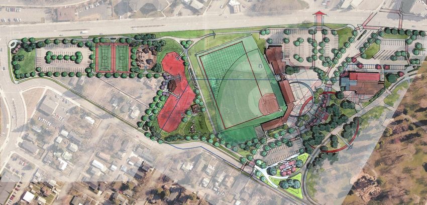
Four Corners/BLM Corridor Master Plan Page 163 Active Recreation Park
This Area Includes BLM and City Property
Proposed Land Use: Outdoor Recreation
Description: The proposed Active Recreation
Park is located north of Memorial Field and
is adjacent to an existing skate park and
small neighborhood park, both on City
Property, and adjacent to Northwest
Boulevard. A short driveway, in the Garden
Avenue ROW, accesses a six space parking
lot. The BLM Parcel is flat with a short slope
up to NW Boulevard and is vacant with
graveled, treed, and brush areas.
Existing Conditions Statement of Need: The existing skate park
is beyond its useful life and does not have
modern skate park features. Its capacity
can’t safely accommodate the growing
number of users and the broader age
demographic found in the Coeur d’Alene
area. The skate park users and supporters
have been very active in this planning
process and with the City to support
development of a larger, modern skate park.
The proposed skate park, located on both
the City and BLM parcels, would be
supported by a restroom facility and picnic
shelter which provides greater opportunities
for “skater families” and skate events.
The existing neighborhood park is also
beyond its useful life and needs replacing
and updating. The replacement park will
support families using the skate park,
Memorial Field and the neighborhood.
Conceptual Uses
This area provides the opportunity to create
outdoor recreation activities not currently
provided in the City; two Futsal Courts
(which can also be basketball, pickleball and
tennis courts) and a bouldering and ropes
course. The City is attempting to provide a
diversity of outdoor recreation opportunities
to meet the needs of a broader demographic
and the proximity of this BLM/City Parcel to
Memorial Field and City Park provides a
logical location.
The additional facilities will need the support
of a parking facility, which is located at the
north end of the planning sub-area.
South end of BLM Corridor Looking North
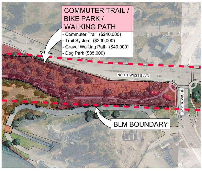
Four Corners/BLM Corridor Master Plan Page 17River Ave. to Hubbard Ave.
Transition Zone 4
This Area Includes BLM Property only
Proposed Land Use: Outdoor Recreation
and Municipal/Educational
Description: The BLM Parcel between River
and Hubbard Avenues is vacant, with the
exception of the building owned by the
Museum of North Idaho, which will be
transferred to the City in 2016 and used in
Existing Conditions
a manner consistent with a BLM
recreational purpose lease. The old
alignment of the Centennial Trail meanders
through the parcel, but is lightly used. The
parcel is relatively flat and sparsely
vegetated with primarily noxious weeds and
some gravel areas. Lightly developed
(temporary parking) NIC property adjoins
the BLM parcel and NIC has discussed a
number of future development options
including an athletic event center, student
housing and administration. Northwest
Boulevard parallels this parcel and presents
considerable traffic noise.
Statement of Need: The primary need for
this area is to support the commuter trail,
which could be buffered from Northwest Conceptual Uses
Boulevard traffic with intensely developed
structured landscaping. A few shaded
bench structures would be provided along
the commuter trail to provide resting
locations for walkers (which is a frequent
request to the City). The remainder of the
area would be weed treated and planted
with native grasses.
This area also presents the opportunity to
transition from the more intensely
developed recreation areas to the south to
the more open space recreation areas to
the north. A transition between Northwest
Boulevard to the future college, City parking
facilities or structures can also occur on the
parcel.
While no formal plans currently exist, this
portion of the BLM parcel can logically BLM Corridor Looking South
support future educational or City buildings
or parking either located entirely or partially
on the parcel.
BLM Corridor Looking North
Four Corners/BLM Corridor Master Plan Page 185A Hubbard Ave. to Harbor Center
This Area Includes BLM and City Property
Proposed Land Use: Outdoor Recreation and
Outdoor Education
Description: This area is primarily covered
with pine trees, very heavily in some areas
with a variety of ages and nicely spaced with
mature trees in other areas. Lower vegetation
is brush and some noxious weeds. The
abandoned railroad bed is graveled. The BLM
parcel is primarily flat and the City parcel
includes flat areas, a small ridge and then
slopes to the Spokane River edge, supported
Existing Conditions by a structured wall. The area is paralleled by
Northwest Boulevard and a private parcel to
the east and City property to the west, which
has the City wastewater treatment plant, a
parking lot, a Spokane River Front building
leased to the University of Idaho for their Coeur
d’Alene campus and an access driveway. The
Centennial Trail crosses through the City
property.
Statement of Need: The trees, topography and
proximity of the parcel to the U of I Campus,
Spokane River, City stormwater and
wastewater facilities, and historic sites drove
the desired uses in this area that will meet the
needs of several underserved outdoor pursuits:
biking, walking trails, Dog Park and education.
Conceptual Uses After selective and sensitive tree removal
(under BLM guidance and in accordance with
City & BLM Parcel Looking North the City’s stringent tree removal policy), the
parcel will support a unique bike park for
mountain, bmx and cyclocross bicyclists. This
same area will support a separate designated
natural walking trail, with compacted gravel to
make it accessible to a variety of users.
City & BLM Parcel Looking South An outdoor structured classroom with tiered
seating and overhead shelter will facilitate
teaching and discussion about stormwater,
wastewater, the Spokane River, nearby Native
American sites, and prior industrial uses of the
area. The City’s stormwater system that
surfaces in this area can be used to
demonstrate different treatment options and
the U of I students can conduct on-going
research.
Four Corners/BLM Corridor Master Plan Page 19Harbor Center to US-95
5B
This Area Includes BLM and City Property
5B
Proposed Land Use: Outdoor Recreation
Description: The Spokane River borders
the City’s parcel to the west along a
structural “seawall” that supports the land
and a small existing waterfront boardwalk.
The U of I access driveway crosses the area
to the south and the US-95 Spokane River Existing Conditions
Bridge passes over the area to the north.
The land area generally slopes east to west
terminating at the seawall approximately 10
feet above the Spokane River. Currently,
there is no access to the Spokane River at
this location. The Centennial Trail passes
through the City Parcel and slopes up from
the seawall area to beneath the US-95
bridge.
Statement of Need: A primary goal of the
Community (as stated in the City
Comprehensive Plan and CDA 2030 Vision
plan) is to preserve and expand access to
the water bodies surrounding the City. This
location provides an excellent opportunity
to create water access considering a
commercial marina was located here until
the mid-1990’s. The proposed marina
facility would be a day use facility and
allow boaters to access the upland facilities
that would include bathrooms and multiple Conceptual Uses
small family size shaded picnic areas.
There are limited locations on the Spokane
River and Lake Coeur d’Alene where
boaters can have a shoreline picnic and
access restrooms, so this location will fill a
large community need. Group picnic
shelters at this location will also meet an
increasing demand on City facilities and
these would be waterfront, adding to their
appeal. The existing small boardwalk
would be expanded to allow boaters, trail
users and others to take in beautiful
Spokane River views. The parking lot
would serve multiple uses at this location
including the Centennial Trail, Dog Park,
Bike Park and picnic shelters.
City & BLM Parcel Looking East
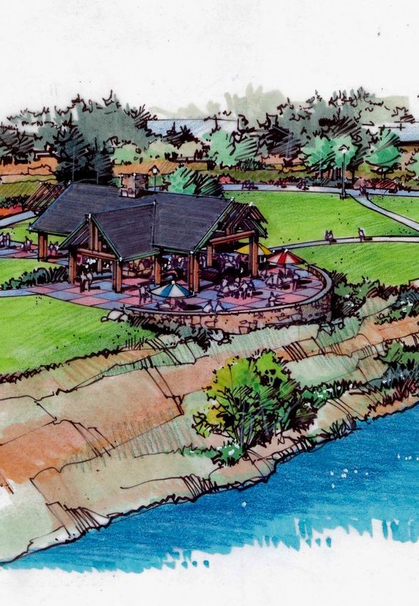
Four Corners/BLM Corridor Master Plan Page 206A US-95 to Lacrosse Park
This Area Includes BLM Property only
Proposed Land Use: Outdoor Recreation
Description: This segment of the BLM parcel is
the most historically disturbed area having
been part of a lumber mill complex, as well as
a railroad corridor. The area is bordered by a
Existing Conditions Union Pacific (UP)parcel to the east, and
private property to the west, which separates
the BLM parcel from the Spokane River. The
area is primarily vegetated with noxious weeds
and the topography is generally flat north and
south, with a small lower bench to the west
and a steep drop into the UP parcel historic rail
bed. The parcel is vacant with the exception of
the Centennial Trail which is located near the
west parcel edge.
Statement of Need: The size and location of
this portion of the BLM parcel provides the City
with an opportunity to meet the outdoor
recreational needs of a growing population on
the west edge of the City. Much of the growth
is this area of the City is multi-family housing,
which makes City provided outdoor recreation
Conceptual Uses all the more valuable and necessary. Since the
parcel has limited mature vegetation, it
provided a “blank slate” opportunity to provide
and organize outdoor recreation in a structured
“classical park” configuration on the north end
(see the following page) and continuing the
bike park walking trails from the treed portion
of sub-area 5 into the more open area of sub-
area 6, which provides views of the Spokane
River to the South. City easements across the
private parcel to the south will allow limited
pedestrian access to the river. The shoreline
in this area is steep with localized areas of
erosion. The pedestrian access will need to be
carefully designed and the erosion areas
repaired. This area also presents the
Picnic Shelter/Restrooms & Centennial Trail Sculpture Park opportunity to construct a waterfront group
picnic shelter with restrooms (which would
also serve Centennial Trail users). The City
does not have any dedicated waterfront group
picnic shelters and this would meet the
community’s need for that type of facility.
Four Corners/BLM Corridor Master Plan Page 21Lacrosse Park to Western End
6B
This Area Includes BLM Property only
Proposed Land Use: Outdoor Recreation
Description: Sub-Area 6B’s existing
condition is the same as 6A. The UP parcel
lies between this area and the City’s
existing Lacrosse Street, which is intended
to provide access to this portion of the BLM Existing Conditions
Parcel. The existing land uses to the east,
beyond the UP parcel, is primarily
commercial, including an RV Campground,
and to the west is residential. The
residential area will limit views to the
Spokane River, but dedicated pedestrian
access easements from Bellerive Drive to
the waterfront boardwalk provide
opportunities to access the River.
Statement of Need: Increasing multi-
family and single family housing to the
northwest is creating a need for active
recreation areas closer to these housing
areas. Riverstone Park, located
approximately ½ mile to the northwest
currently has open space, amphitheater,
walking trails, and small playground and Conceptual Uses
picnic shelters. Additional structured
sports areas are necessary and the
proposed large green space for micro- BLM Parcel Looking S.E.
soccer or junior tackle football and the
combination pickle ball/tennis courts will
meet that need. The parking lot will
support the park along with restrooms and
smaller picnic shelters. The large parcel
area provides enough remaining space to
create a native plant arboretum as well as a
sculpture park that will appeal to many park
and Centennial Trail users.
BLM Parcel Looking NW
Four Corners/BLM Corridor Master Plan Page 22Chapter 3 Development and Improvement Plan
Proposed Improvements Vision 2030
Implementation Plan Elements
The proposed improvement projects (Projects) consist of
individual or a group of concepts that could be efficiently The following Vision 2030 Plan Elements are part
and cost effectively constructed together and could likely be of this Master Plan:
• Four Corners Steering Committee - Form a Four
funded in a single fiscal year, possibly, and most likely Corners Steering Committee to identify strategies
through multiple funding sources. The Projects are and partnerships to acquire ownership and/or
preserve public access to the Burlington
presented in the following pages by planning sub-area and Northern Santa Fe (BNSF) Corridor.
provide information necessary for City planning and to • RR Rights-of-Way Acquisition - Acquire railroad
satisfy the BLM Plan of Development requirements. The rights of way for major trail expansions and
connections.
information includes: • Urban Stormwater Best Management Practice -
Integrate innovative Stormwater Best
• A graphic conceptual level plan of improvement Management Practice (BMP) Demonstration
• Description of the proposed improvement Projects into Public Works Projects, including
“green” urban infrastructure.
• Proposed Improvement conceptual level opinion of • Public Beaches - Evaluate and recommend ways
cost to increase access to public beaches, including
ADA disabled access. Consider an off-leash
• Possible Source of Funds water access area for dogs.
• Timetable for Development • Bike Park Facility - Develop a bike park that will
include a BMX freestyle track, jumps and
• Maintenance Responsibility cyclocross.
Additionally, example pictures of proposed improvements • Renovate & Expand Skate Park - Renovate and
expand the downtown skate park to
are provided in an attempt to effectively communicate the accommodate modern users and competitions.
idea along with aerial and site photos of the BLM Parcel to • Family Friendly Outdoor Events - Promote
additional family friendly outdoor family events
demonstrate existing site conditions. i.e. cross country ski trails.
• Trail Expansion and Connections - Obtain
Management Plan railroad rights of way for major trail expansions
and connections.
In order to achieve the lowest annual rental cost per acre • Preserve View Corridors - Support zoning which
and final purchase price, the City, as authorized by the City would limit building heights in order to preserve
major view corridors and signature vistas in and
Council, agrees to the following commitments, which will be around the lakefront and river.
incorporated by reference in the conveyance of the subject • Lakefront and Riverfront Public Access - Require
lands: public access to the lake and river fronts for all
new developments.
1. To maintain the lands open to use by the public for • ADA Lake Access - Develop and identify with
signage, appropriate American Disability Act
recreational purposes without discrimination or favor. (ADA) access points for disabled access along
2. To make no more than a reasonable charge for the the lake and river fronts.
use of facilities on the land (whether by concession
or otherwise) and to charge no more for entrance to
and use of the area than is charged at other comparable installations managed by the
State and local agencies. The Commission will submit to the Bureau of Land
Management its schedule of charges. All charges shall be subject to review for
conformance with this requirement and appropriate modification by the Secretary of the
Interior or his delegate after reasonable notice and opportunity for hearing.
3. To develop and manage the lands in accordance with the approved program of
utilization, submitted with this application.
4. To secure the approval of the Secretary of the Interior or his delegate of all plans of
construction prior to commencing actual construction.
5. To maintain in satisfactory condition the facilities on these lands.
Four Corners/BLM Corridor Master Plan Page 23Independence Point City Park
Parking Lot & Waterfront Promenade 1
This area includes City Property only
Description of Proposed Improvements:
City Parking Lot: The City Park Parking Lot
improvements will consist of demolition of
the existing parking lot and construction of
the new parking lot including earthwork,
site grading, curbing, asphalt pavement,
landscaping and lighting improvements.
The Centennial Trail improvements would
also be constructed at this same time.
City Beach Boardwalk: The boardwalk
improvements will consist of demolition of
the existing concrete sidewalk and
construction of a larger pedestrian area and
boardwalk including, site grading, concrete
hardscaping, shade structures, benches, a
boardwalk, landscaping and lighting
improvements.
Independence Point: Three options are
available for Independence Point varying
from complete reconstruction to a
dedicated pedestrian open space to leaving
it as a waterfront parking lot to somewhere
in between. Due to the passionate views
for all of the options, the City will likely
pursue a separate public input process on
this project.
Proposed Possible Time Maintenance
Project Source Table Responsibility
of Funds Movable ADA Accessible Beach Walk
City Parking City 2016 City Example
Lot
City Beach City 2030/ City
Boardwalk 2031
Independence City TBD City
Point
Shade Structures
Example
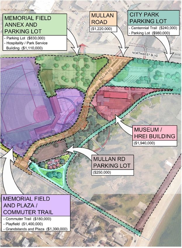
Four Corners/BLM Corridor Master Plan Page 242 Memorial Field & Mullan Road
This area includes City Property only
Description of Proposed Improvements
Mullan Road: The realignment and narrowing of Mullan
Road to create a pedestrian friendly corridor will include
demolition of the existing five lane roadway and
reconstruction with a curved alignment and speed table,
stormwater system changes, grading, curbs, sidewalk,
pavement, lighting and landscaping. The parking lots and
Memorial Plaza will include minor earthwork and grading,
support utilities, hardscape and landscape surfacing and
lighting.
Museum/HREI Building: The Museum/HREI Building
would include a remodel of the existing historic railroad
“battery building” and the addition of a new building to
support the Museum/HREI. This is a very preliminary
concept and its implementation would require multiple
forces to come into alignment. The concept and cost
estimate were presented primarily for discussion
purposes.
Mullan Road Parking Lot: This parking lot is intended to
serve the underused corner of City Park and the Workers
Memorial and to replace on-street parking removed with
the Mullan Road reconstruction. Construction would
include grading, curbs, sidewalk, pavement, lighting and
landscaping.
Memorial Field and Plaza/Commuter Trail: Memorial
Field reconstruction would include realigning the field for
better solar orientation and improved pedestrian and
vehicle safety by reducing batted ball conflicts, and
rehabilitating the historic grandstands, including grading
and building reconstruction. The plaza would include
sidewalk, shade structures, lighting and landscaping. The
commuter trail would include grading and pavement.
Memorial Annex and Parking Lot: This parking lot would
serve Memorial Field and include grading, curbs,
sidewalk, pavement, lighting and landscaping. The Annex
building would serve as a commercial opportunity to
augment Memorial Field services.
Proposed Project Possible Time Maintenance
Source of Table Responsibility
Funds
Mullan Road City 2016 City
Museum/HREI Building Private TBD Private
Mullan Road Parking Lot City 2016 City
Memorial Field City/Private/NIC 2020 City
Memorial Plaza City 2016 City
Commuter Trail City/Non-Profit 2016 Non-Profit
Memorial Annex Private 2033 Private
Memorial Parking Lot City 2016 City
Workers Memorial Private 2017 City
Four Corners/BLM Corridor Master Plan Page 25You can also read