Templestowe Road Soccer Facilities (27-59 Templestowe Road) Master Plan - May 2020 - AWS
←
→
Page content transcription
If your browser does not render page correctly, please read the page content below
Templestowe Road Soccer Facilities
                                                        (27-59 Templestowe Road)
                                                        Master Plan

     May 2020

Authorised and published by the Victorian Government,
1 Treasury Place, Melbourne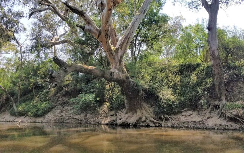
Acknowledgment of Country
The North East Link Project (NELP) respectfully acknowledges the Traditional
Owners of the land and pays respect to their Elders, past, present and emerging.
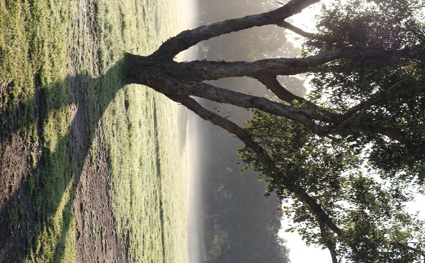
Figure 1 Yarra River. Image: Sophie Rae
1 North East Link I Templestowe Road Soccer Facilities (27-59 Templestowe Road) Master Plan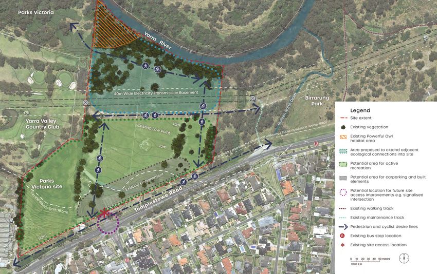
Table of contents

1.    Introduction                            3
1.1 Project overview                          3

1.2 Purpose of this Master Plan               4

1.3 Project methodology                       4

2.    Strategic context                       5
2.1 Background documents                      5

2.2   Site specialist assessments             5

2.3   Strategic planning context              5

2.4   Broad trends in sports and recreation   8

3.    Site context and design input           9
3.1   Existing conditions                     9

3.2   Place values                            9

3.3   Stakeholder engagement                  12

4.    Design approach and principles 13
4.1 Design approach                           13

4.2   Overarching Design Principles           13

4.3 Vision                                    14

5.    Master Plan                             15
5.1   Scope                                   15

5.2   Master plan design intent               15

5.3   Key design directions                   15

5.4 Other Design Considerations               18

6.    Glossary of terms                       19
7.    References                              19

                                                    North East Link I Templestowe Road Soccer Facilities (27-59 Templestowe Road) Master Plan   2
1.       Introduction
1.1     Project overview
To facilitate the construction and operation of North East Link
(NEL), some sporting facilities and user groups around the North
East Link Eastern Freeway Interchange will need to be relocated,
including two existing soccer fields located at Bulleen Park.

Several options for the relocation of the sport and recreation
facilities in the Bulleen Park area were investigated as part of the
Environment Effects Statement (EES) process as documented in
EES Chapter 17 Social, and Technical report I – Social, Appendix
F - Sport and Recreation Options Assessment. Since that time
further work has progressed to find a suitable site for relocation
of displaced facilities.

The site at 27-59 Templestowe Rd, Bulleen, is proposed to be
developed with three soccer fields and ancillary infrastructure to
provide a new facility for the sporting community. This document
sets out a Master Plan for the proposed development (the
project) of 27-33 Templestowe Rd (Parks Victoria land) and 35-59
Templestowe Rd (hereafter referred to as the site), and as shown
in Figure 2, to accommodate the relocation of the impacted
soccer fields. The site currently contains a golf driving range and
an open space reserve.

Figure 2 Site context map

3     North East Link I Templestowe Road Soccer Facilities (27-59 Templestowe Road) Master Plan
1.2   Purpose of this Master Plan                                   1.3     Project methodology
The purpose of this Master Plan document is to document the         This master planning process represents a small step within            The Master Plan will provide direction for the next stage, being
project approach, site analysis and Design Principles, and to       a larger design program to deliver a number of new sporting            detailed design, in terms of:
define a clear scope for the re-development of the project site.    facilities as part of the NELP Sports and Recreation Re-location
                                                                    Program. Several key steps have been undertaken to reach this          Vision and Overarching Design Principles –
This Master Plan will be submitted for approval by the Minister     design milestone. Underpinning this process has been a rigorous        Drivers for delivering a successful re-development project
for Planning as part of draft Planning Scheme Amendment             stakeholder consultation program, which is outlined in Section
c132mann. Use and development for the purposes of the project       3.3. This report documents the milestones completed to Master
must be carried out in general accordance with the approved
                                                                                                                                           Master Plan Key Design Directions –
                                                                    Planning as shown below in Figure 3.
Master Plan. The Master Plan may be amended as a condition of                                                                              Identification of key strategic directions to deliver on the Design
the Templestowe Road Soccer Fields Development Incorporated                                                                                Principles
Document (Incorporated Document) which forms part of the draft
Planning Scheme Amendment. The Master Plan shall:                                                                                          Other Design Considerations –
• Undertake a context analysis, and identify challenges and                                                                                Detailed design requirements relating to particular design
  opportunities                                                                                                                            elements

• Convey the design intent for this project
• Develop a vision and range of Design Principles along with Key
  Design Directions and Other Design Considerations to guide,
  inform and evaluate the detailed design of the project site.
• Inform the preparation of a Development Plan to be approved
  by the Minister for Planning as a condition of the Incorporated
  Document.

                                                                    Figure 3 Key project milestones

                                                                                                                            North East Link I Templestowe Road Soccer Facilities (27-59 Templestowe Road) Master Plan   4
2.         Strategic context
2.1      Background documents                                                         2.2     Site specialist assessments                                State Football Facilities Strategy to 2026, Football
A number of documents have been reviewed to inform
                                                                                                                                                         Victoria (formerly Football Federation Victoria), 2018
                                                                                      A range of specialist assessments were carried out to
preparation of this Master Plan document and strategic                                understand the existing site conditions and potential impacts of   The State Football Facilities Strategy to 2026 outlines how the
directions, including:                                                                development of the site to inform preparation of the proposed      State could deliver sporting facilities and infrastructure across
                                                                                      Master Plan, including:                                            Melbourne and region over an eight year period. The strategy
Federal policy and strategic reports                                                                                                                     particularly focuses on “Facilities and Infrastructure” being one
                                                                                      • Templestowe Road Soccer Facilities Contamination Impact          of the five strategic pillars of Football Victoria’s Strategic Plan
• National Sport and Active Policy Framework, Australian
                                                                                        Assessment, North East Link Project, GHD[a], 2020                namely:
  Government, 2011
                                                                                      • Templestowe Road Soccer Facilities Ecology Impact
State and local policy and strategic reports                                            Assessment, North East Link Project, GHD[b], 2020                 • Our clubs
• Active for Life Recreation Strategy 2010-25, Manningham City                        • Templestowe Road Soccer Facilities Arboriculture Impact           • Facilities and Infrastructure
  Council, (Reviewed 2019)                                                              Assessment North East Link Project, GHD[c] 2020
                                                                                                                                                          • Enjoying our game
• Active Victoria - A strategic framework for sport and recreation                    • Templestowe Road Soccer Facilities Landscape and Visual
                                                                                                                                                          • Promoting our game
  in Victoria 2017-2021, Victorian Government, 2017                                     Impact Assessment, North East Link Project, GHD[d], 2020
                                                                                                                                                          • Our people
• Draft Yarra Strategic Plan, Melbourne Water, 2020                                   • Templestowe Road Soccer Facilities Traffic & Transport Impact
• Draft Yarra River - Bulleen Precinct Land Use Framework Plan,                         Assessment, North East Link Project, Smedley Technical &         Strategic Plan 2019-2022, Football Victoria, 2019, Page 9

  Department of Environment, Land, Water and Planning, 2019                             Strategic, 2020
                                                                                                                                                         The State Football Facilities Strategy to 2026 sets out priority
• Draft Yarra River Corridor Concept Plan – Manningham City                           • North East Link Project Environment Effects Statement, Social    actions to deliver new and improved facilities across Victoria for
  Council, 2019                                                                         Impact Study, Appendix 2 Bulleen Park Area Sports and            the sport to be able to sustain the expected growth of our cities.
                                                                                        Recreation Options Assessment, North East Link Project, March
• North East Link Urban Design Strategy, North East Link Project,                       2019                                                             Application to the site
  23 March 2020
                                                                                      • Bulleen Park Relocation Options - Aboriginal cultural heritage   Manningham City Council is located within the Metro North East
• Outdoor Sports Infrastructure Guidelines, Manningham City                             implications for development, Andrew Long & Associates, 2019     Zone, as identified in the strategy and is expected to require
  Council, 2015
                                                                                      Key strategic documents relevant to this sports and recreation     a total number of 12 fields by 2026, based on a projected 5%
• Sports Dimensions Guide for Playing Areas, Department of                            Master Plan are explored in further detail in Section 2.3.         growth in participation rates.
  Sport and Recreation, Government of Western Australia, Sixth
  edition, 2016                                                                                                                                          The priority actions relating to the project site as identified in the
                                                                                      2.3     Strategic planning context                                 State Football Facilities Strategy to 2026 are:
Legislative and other documents
                                                                                      The key polices, plans and strategies that set out directions
• The Yarra River Protection (Wilip-gin Birrarung murron) Act, 2017                   relevant to development of this Master Plan document and the        • Find new pitches or opportunities to extend capacity in
• Manningham Planning Scheme, Manningham City Council                                 initiatives proposed are summarised below.                            Boroondara and Manningham
                                                                                                                                                          • Consider facility developments Bulleen Park, Bulleen to
Key industry strategic frameworks and guidelines                                                                                                            further establish as a key regional venue
• State Football Facilities Strategy to 2026, Football Victoria                                                                                          State Football Facilities Strategy to 2026, Football Victoria, 2018, Page 35
  (formerly Football Federation Victoria), 2018
• Strategic Plan 2019-2022, Football Victoria, 2019                                                                                                      The project site is recognised as a suitable location to redevelop
                                                                                                                                                         a soccer facility to replace Bulleen Park impacted by NEL and to
                                                                                                                                                         deliver on the Football Victoria’s infrastructure plan into the future.

5     North East Link I Templestowe Road Soccer Facilities (27-59 Templestowe Road) Master Plan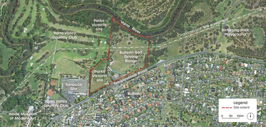
Draft Yarra River - Bulleen Precinct Land Use Further, key actions identified as relevant to the master planning
Framework Plan, DELWP 2019 of this site include:
The preparation of this plan followed on from the work of the
• 1.2 Restore and link the study area’s remnant indigenous
Yarra River Protection Ministerial Advisory Committee which
landscapes by re-vegetating a portion of private
recommended development of an integrated plan to provide
landholdings and leased Crown land where they directly
direction to future land use changes in the area. This part of
front the Yarra River. Revegetation should be undertaken
the Yarra River is recognised as being subject to transitioning
at a depth sufficient to achieve minimum ecological
land uses as a consequence of development and infrastructure
outcomes and to support a pathway connection.
pressures.
• 2.2 Structure the future pedestrian and cyclist network
The plan has been prepared to translate the values of the Yarra to accommodate (and where necessary, separate)
River Protection (Wilip-gin Birrarung murron) Act 2017 and is different types of users, by considering accessibility
underpinned by detailed objectives which propose: needs at a regional, subregional and local scale (noting
that final plans for the future trail network must also
• Reconnected parklands and ecological landscapes, be balanced with protection of cultural values, natural
increasing the open space footprint and filling in the vegetation and riparian environment).
gaps of the Greater Yarra Urban Parklands. • 4.4 Facilitate the development of new open spaces
• United key walking and cycling routes, ‘knitting’ together at the Bulleen Golf Driving Range site and on the
key places within the study area and beyond, including balance of the Yarra Valley Country Club site and 27-33
to public transport routes and activity centres. This Templestowe Road to complement adjoining residential
results in improved community access and connection to development. Revegetate a habitat corridor along the
the Yarra River and will reinforce the study area’s future Yarra River frontage.
role as a cultural and recreational destination. • 4.6 Consistent with the provisions of DD02, facilitate
• An internationally significant cultural place, centred on a new low-rise built form in defined locations that
the relationship between the arts, nature and Traditional reflect the parkland setting and surrounding residential
Owner heritage, with Heide Museum of Modern Art neighbourhoods. Create a strong built form edge with
to be expanded and two potential new cultural hubs uniform setbacks to Banksia Street, Manningham Road
established. West and Bulleen Road. Ensure the new built form
• A complementary mix of uses, where public and private prioritises public access to the Yarra River and parklands
uses are better connected and add value to each other. and avoids ‘gated’ privatised spaces.
• 4.8 Support public pedestrian access along the entire
Draft Yarra River - Bulleen Precinct Land Use Framework Plan, 2019, Page 7
stretch of both sides of the Yarra River through the study
Application to the project site: area.
The site is specifically identified as providing the opportunity for Draft Yarra River - Bulleen Precinct Land Use Framework Plan, 2019,
Page 47-51
expansion of parkland and potential active recreation with the
northern part of the site, flanking the Yarra River, providing an The two land parcels which make up this site are each identified
expansion of parkland and ecological connections. Surrounding as key sites whose proposed future use is open space/
Figure 4 Extract from the Draft Yarra River Bulleen Precinct Land
lands are shown as parklands. The entrance to the site off recreation/conservation.
Use Framework Plan. Land use and culture plan), Department of
Environment, Land, Water and Planning 2019 Templestowe Road is flagged as providing for improved parkland
access for pedestrians. Future work is identified to facilitate implementation of the
framework plan including land acquisition and assembly, built
form modelling and planning scheme amendments.
Note: The Draft Yarra River - Bulleen Precinct Land Use Framework Plan, 2019
is a draft only, and is subject to change through separate planning approval
processes.
North East Link I Templestowe Road Soccer Facilities (27-59 Templestowe Road) Master Plan 6
The Yarra Strategic Plan is to guide and manage activities The key directions for future land use and development, to be the
on public and private land and is defined as applying to land subject of future amendments to planning scheme provisions,
within one kilometre of the banks of the Yarra River. Actions, relevant to this Master Plan are:
responsibilities and timeframes are set out under each
Draft
performance objective. • Ensure the existing landscape corridor along the Yarra
YARRA Application to Project Site:
River is protected and reinforced as a vital habitat link
and place of refuge.
STRATEGIC The site is located within the Suburban Reach of the corridor. • Ensure a coordinated approach to landscaping,
PLAN The plans notes that over 50km of the Yarra River runs through
Manningham City Council with over 1000 ha of “Yarra River land”
wayfinding and the provision of visitor facilities to
encourage people to view the Yarra River as one living
A 10 year plan for the Yarra River corridor -
draft for public consultation in the council area. Yarra River land is defined as including the entity.
“bed, soil and banks of the Yarra River and Crown and state
• Ensure development is screened from view from the
government owned land parcels within 500 metres of a bank of
Yarra River (and key viewing locations) by a canopy of
the river.” (Melbourne Water, p16) The land use framework sets
Draft Yarra Strategic Plan – confidential Part i
native trees and understorey planting.
out future directions for private and public land. The key aims of
relevance to this site are to: • Ensure development is sited and designed to maintain
and enhance the Yarra River’s secluded and natural
Draft Yarra Strategic Plan, Melbourne Water, 2020
• Strengthen the vegetation buffer along the Yarra River, environment.
The draft Yarra Strategic Plan is a 10 year overarching policy
between public and private land, while maintaining a • Ensure development is set back from the Yarra River’s
and planning framework for the Yarra River corridor and is
diversity of landscapes through the parklands. New edge to protect and strengthen a continuous corridor of
underpinned by a community vision developed in accordance
landscape guidelines will provide guidance for the native vegetation along the Yarra River and to maintain
with the directive in The Yarra River Protection (Wilip-gin Birrarung
implementation of stronger planning controls and enable corridor views. Development must also be set back from
murron) Act 2017. Ten year performance objectives are detailed
a consistent approach to planting adjoining parklands and conservation areas to protect
as follows:
• Promote opportunities to extend and link parklands the natural landscape.
when land becomes available, improve recreational trails • Design buildings to respect the Yarra River’s sensitive
• A healthy river and lands: Improving the water quality of
along the Yarra River and its tributaries and improve landscape setting.
the Yarra River and protecting its land, floodplains and
community infrastructure • Protect and strengthen native vegetation across rural
billabongs to achieve greater biodiversity.
Draft Yarra Strategic Plan, Melbourne Water, 2020, Part 2b, Page 99 and bush residential land to provide habitat connections
• A culturally diverse river corridor: Acknowledging,
between conservation areas and along the Yarra River
protecting and commemorating the rich heritage of the
and its tributaries.
Birrarung and its stories.
• Development in flood affected areas should refer to the
• Quality parklands for a growing population: Improving
Guidelines for Development in Flood Affected Areas.
the river’s parklands to support community wellbeing
and strengthen the relationship between the Yarra River, Draft Yarra Strategic Plan, Melbourne Water, 2020, Part 2b, Page 100-101
its community and visitors.
These directions are set out as applying to Yarra River Land and
• Protecting the natural beauty of the Yarra River Bush residential respectively; however, they are considered to
corridor: Respecting the significance of the Yarra be equally applicable to this site given its context relative to the
River’s landscapes. Where we build, we will protect and Yarra River despite it being designated as ‘Yarra River land’.
celebrate the river’s natural beauty, landscapes and
Note: Draft Yarra Strategic Plan, Melbourne Water, 2020 is a draft only, and is
views.
subject to change through separate planning approval processes.
Draft Yarra Strategic Plan, Melbourne Water, 2020, Page 15
7 North East Link I Templestowe Road Soccer Facilities (27-59 Templestowe Road) Master Plan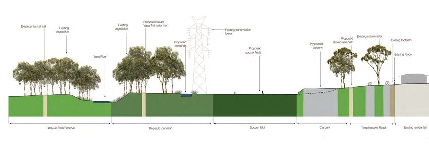
2.4    Broad trends in sports and recreation                           Adaptation and diversification of soccer facilities for
                                                                       flexible lifestyles
Interest in sports and recreation activities is increasing thanks to
introduction of new sports, adaptation to changes in our daily         As modern work patterns change and the lifestyle pressures
lives in response to technology, and the growing demand in             associated with money, time and transport, impact recreation
participation due to population densification in cities. There are a   participation, the focus on flexible and agile service provision is
number of broad trends influencing these strong growth signals         growing. Sporting facilities are increasingly being co-located with
both nationally and globally. Soccer, in particular, is affected by    other passive recreation or community facilities to offer traditional
these which makes this re-development an exciting opportunity          and non-traditional experiences. Equally, soccer service delivery
to consider current and future trends that will impact the             is adapting to new technologies to improve participation and
functionality and operation of the new facility.                       engagement through innovative technical skills sessions and
                                                                       online tutorials.
The trends have been distilled from the listed key industry
strategic frameworks, policies and plans, in Section 2.1, and          Planning facilities for increasing demand
reinforce the opinions of Manningham City Council and clubs
                                                                       Sporting and recreation infrastructure is increasingly being
voiced during the Master Plan design sessions.
                                                                       designed and retrofitted to accommodate the changing needs
Increased levels of female soccer participation                        of Australia’s growing population and to entice new participants.
                                                                       Football Federation Victoria’s Strategic Plan identifies the supply
Soccer is experiencing greater levels of interest globally and         of high quality infrastructure as a critical element for livelihood
locally from women and girls affecting the type and supply of          and growth of soccer in Victoria. This includes providing and
facilities, programming and training practices. It is the vision of    retrofitting facilities with a range of large and small-scale
Football Federation Victoria that by 2028 every soccer club in         improvements to accommodate increased demand. This is
Australia will have a girls’ team and that Australia will have a       evident in the increased use of pitch lighting to extend useable
50/50 gender participation rate.                                       hours and the re-surfacing of fields with durable synthetic or
                                                                       hybrid surfaces to accommodate increased use and make
Increased social participation uptake associated                       surfaces more resilient.
with improved community health and wellbeing
It is widely recognised that physically active people are more
likely to be healthier and experience higher degrees of mental
wellbeing than those who are not as active. Further, the social
element associated with organised sports plays an important role
in creating and maintaining connected communities. In response
to the heightened awareness of the benefits of social sport
participation, clubs are increasingly providing a greater diversity
of participation opportunities and facilities to appeal to a wider
participation base across the community.

                                                                                                                                                  Figure 5 Women’s soccer. Image: Ally Middleton

                                                                                                                                   North East Link I Templestowe Road Soccer Facilities (27-59 Templestowe Road) Master Plan   8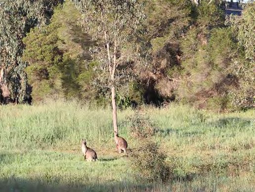
3.         Site context and design input

3.1      Existing conditions                                    wilderness and cultural heritage. To the wider                                                                       3.2     Place values
                                                                urban area, the valley of the Yarra River
Surrounding area                                                provides a central corridor for nature, as well as                                                                   The location and cultural heritage of the site
                                                                a tranquil backdrop of semi-natural landscapes                                                                       contribute greatly to its value and inherent
The surrounding area is varied in use.                                                                                                                                               spatial characteristics. These place values are
                                                                of the community sports facilities, bushland and
                                                                grasslands.                                                                                                          the physical attributes that contribute to the
Residences are located to the south of the site
                                                                                                                                                                                     project site’s sense of place and have been
along the southern side of Templestowe Road.
                                                                The project site features several notable                                                                            considered through the Master Plan design
Land surrounding the site to the east, north and
                                                                physical characteristics presenting                                                                                  process.
west, is generally a mix of public or private open
                                                                opportunities for the redevelopment of the site.
space including the Yarra Valley Country Club
and Birrarung Park, and presents an open feel
                                                                These include:                                                                                                       Cultural landscape and connection to
to the locality. The exception is the commercial                • The undulating topography of the site which
                                                                                                                                                                                     country
premises to the west and the Heide Museum                         has a fall of 12 m from its southern boundary                                                                      The Yarra River flows through the project site
of Modern Art. The Yarra River is located to the                  along Templestowe Road down to its                                                                                 on the traditional land of the Wurundjeri people.
immediate north of the site.                                      northern boundary near the bank of the Yarra                 Figure 8 Spotted gum in the Driving Range carpark.    The waterway, its natural landscape and key
                                                                                                                               Image: NELP
                                                                  River.                                                                                                             features, have social, cultural and spiritual
Project site                                                    • The lack of public accessibility to the                                                                            significance, with areas such as the river
The project site is located in Bulleen and                        northern portion of the project site. This                                                                         flats and billabongs having been important
comprises multiple land parcels at 27-59                          presents a significant opportunity to unlock                                                                       gathering spots. The Yarra Strategic Plan notes,
Templestowe Road. The eastern portion of the                      accessibility and better connect the project
site accommodates the privately operated                          site with the broader Yarra River open space                                                                        To the Wurundjeri Woi wurrung people, the
Bulleen Golf Driving Range. The driving range                     corridor consistent with a number of policies                                                                       river is known as the Birrarung, meaning
is accessible to the public between 9am                           concerning the river and its environs.                                                                              ‘river of mists and shadows’. It is the sacred
and 8pm, with a fee payable upon entry. The                                                                                                                                           lifeblood of their Country, providing food,
                                                                • The overhead electrical transmission lines
western portion of the site is comprised of a                                                                                                                                         water and meeting places, as well as being
                                                                  that distinctively mark the site landscape.
Parks Victoria reserve which is not accessible to                                                                                                                                     a central element in the Wurundjeri Woi
                                                                  These cut across the project site and nearby
the public.                                                                                                                                                                           wurrung people’s cultural and spiritual life.
                                                                  recreational areas.
The Yarra River delineates the northern                         The project site opportunities and constraints                                                                       Draft Yarra Strategic Plan, Introduction Part 1,
                                                                                                                                                                                     Melbourne Water, 2020, Page 11
perimeter of the project site. The river corridor               Plan (refer Figure 3) depicts the key spatial
provides a place of seclusion for wildlife,                     parameters that have guided the general                                                                              There is an opportunity to reflect the intent of
                                                                arrangement of this Master Plan.                                                                                     the Yarra Strategic Plan by recognising the
                                                                                                                               Figure 9 Driving Range shade structure. Image: NELP   significance of the project site as a place to be
                                                                                                                                                                                     celebrated and respected, especially the Yarra
                                                                                                                                                                                     floodplain and riverbanks.

Figure 6 View from the Yarra River (Birrarung).                 Figure 7 Kangaroos at the Parks Victoria site to the west of   Figure 10 Driving range. Image: NELP
Image: Sophie Rae                                               the Driving Range carpark. Image: NELP

9     North East Link I Templestowe Road Soccer Facilities (27-59 Templestowe Road) Master Plan
Ecology Arboriculture
Landscape, environmental and cultural Public open space and access
Although this area of Melbourne is urbanised The project site features a number of large values • To maintain and protect linear public open
and fragmented as a result of historical land canopy trees. Approximately 85% of trees
• To protect and enhance the natural space and provide for secluded areas of
clearance, the woodlands along the Yarra River on site are either indigenous or native to
landscape character of the Yarra River public open space with appropriate public
are the most extensive areas of vegetation that Victoria. 51% of the trees are either River
corridor where the river, its topography, access to the river and its public open
remain within this part of Melbourne (GHD[b], Red Gum, Swamp Gum, Yellow Box or Silver
adjacent public open space and a space.
2020). These areas of high-value habitat attract Wattle (GHD[c], 2020). A total of 298 trees
continuous corridor of vegetation and • To encourage bicycle and shared paths
and support a range of common, uncommon, were assessed including categories of health,
canopy trees are the dominant features. that are well located, avoid unnecessary
and rare fauna, including threatened species structure and useful life expectancy (ULE), and
(such as the Powerful Owl and Grey-headed retention as follows: • To protect, rehabilitate and expand earthworks and vegetation removal
Flying-fox) including other noteworthy nocturnal a continuous corridor of riparian and and have good visibility to help increase
species (such as the Sugar Glider). Scattered • 75 trees have a high retention value indigenous vegetation using appropriate safety for users.
tree habitat on the site provides more • 105 trees have a moderate retention value indigenous species. Siting and design of built form
fragmented habitat of varying value. • 111 trees have a low retention value • To protect and enhance both terrestrial • To minimise the visual intrusion of
and aquatic habitat to allow the buildings and works when viewed from
The project site has been largely cleared of • 7 trees have no retention value
movement of wildlife within the Yarra River the Yarra River and adjacent public open
indigenous native vegetation (GHD[b], 2020). There is a mature Spotted Gum specimen corridor. space, bicycle and shared paths and
The four primary vegetation types that occur on located near Templestowe Road in a ‘fair to
the project site are: • To protect and conserve areas of known bridge crossings.
good condition’ with a Useful Life Expectancy
indigenous and non-indigenous cultural or • To ensure buildings are sited and
• Introduced grassland: The majority of the site of at least 10 years (GHD[c], 2020). Its retention
archaeological significance. designed to reduce visual contrast with
supports mown grassland. Native species are is desirable to provide an element of significant
visual amenity for the grounds of the proposed Protection of waterway and the riparian the natural landscape character setting of
absent from this vegetation type
sporting facility. zone the Yarra River corridor.
• Planted vegetation: Much of the treed
• To ensure buildings and works are set • To ensure all buildings are subordinate to
vegetation has been planted for amenity Landscape use and character back from the banks of the river to protect the existing vegetation with all views of
purposes and comprises a range of locally
The Yarra River has state and metropolitan existing riparian vegetation, habitat buildings filtered through vegetation.
indigenous native trees, non-indigenous
significance as an environmental, aesthetic, and not impede its natural flood and • To ensure all fencing within close proximity
native trees, and introduced species
cultural, recreation and tourism asset. The watercourse characteristics. to the Yarra River is low in scale, visually
• Native vegetation patches: Three small
Manningham City Council Planning Scheme, • To maintain and protect the river’s natural permeable and does not create contrast
patches of native ‘Floodplain Riparian
along with adjoining planning schemes, seeks geomorphology, banks stability and with its natural landscape character.
Woodland’ vegetation occur within the
to further protect its landscape character reduce the risk of erosion.
project site Manningham City Council Planning Scheme -
through Schedule 2 to the Significant • To reduce the rate or quantity of Schedule 2 to Clause 42.03 Significant Landscape
• Scattered native trees: A number of scattered Landscape Overlay (SLO2). The overlay Overlay (SLO2), Page 1-2
stormwater, sediment or other pollutants
native trees occur within the broader matrix recognises the Yarra River and its open spaces directly entering watercourses or The implications of these policy parameters are
of introduced grassland vegetation are one of Melbourne’s most important natural wetlands. that development should be confined to the
Opportunities exist within this environment to assets and at risk of losing their distinctive
southern part of the site, the land comprising
divert built structures and pathways away sense of place through inappropriate
the Yarra River floodplain protected, and the
from significant vegetation and habitat sites, development. SLO Objectives are set out for Manningham City Council Planning Scheme -
place values retained and enhanced, and
and to link areas of scattered tree habitat to “Landscape, environmental and cultural values; Schedule 2 to Clause 42.03 Significant Landscape
Overlay (SLO2), Page 1-2 the place values retained and enhanced.
improve the bio-connectivity and inform the Protection of waterway and the riparian zone;
Accordingly, active recreation programs will be
best location for integrated water treatment Public open space and access; and Siting and
directed towards Templestowe Road.
and storage initiatives, such as a wetland. design of built form.” (SL02, p1-2) The SL02
Significant sites are also shown in Figure 11 objectives relevant to the preparation of a
Opportunities and Constraints Plan on page master plan for the project site are:
11 to indicate areas that need to be
preserved and protected.
North East Link I Templestowe Road Soccer Facilities (27-59 Templestowe Road) Master Plan 10Figure 11 Opportunities and Constraints Plan 11 North East Link I Templestowe Road Soccer Facilities (27-59 Templestowe Road) Master Plan
3.3 Stakeholder engagement Key engagement outcomes Early 2018 Initial Planning Stage
The key messages out of the engagement Initial sports
Overview process focused on maintaining the club meetings
Development of this Master Plan document was functionality and continuity of the soccer
Stage 1 Master Plan
informed by stakeholder engagement together facilities, while also placing high value on August 2018
(4 Initial Options For Bulleen Park Area)
with background research and site analysis. balancing the sporting needs with the natural Sports club /
Design workshops were held to explore the values of the riverside setting in which the stakeholder
key issues and opportunities for the project facilities will operate. workshop
site and involved stakeholder representatives Stage 1 Concept Master Plan
A number of key themes and values were January 2019
from Manningham City Council and Football (Options 1-7)
Victoria, sports clubs including Templestowe identified including:
Council
United Football Club, Bulleen Lions Soccer Club • Growth in female soccer participation officer
(Veneto Club), Sport and Recreation Victoria, workshops
• Design for universal access June 2019 Public Exhibition of Sport &
statutory land owners such as Parks Victoria Recreation Options Assessment
Templestowe
and Melbourne Water, and the Department of • Community health and wellbeing Road Pavilion
Environment, Land, Water and Planning. • Need for family friendly facilities Design
Workshops
Key engagement activities • The opportunity to redevelop privately EES Panel Hearing and Master Plan
September 2019
operated recreational open space for public Submission
Between March 2018 and March 2020, a broad recreational purposes with free entry access
range of engagement activities took place to
• Balancing community infrastructure with
inform the Master Plan including sports club
natural values Stage 2 Concept Master Plan
workshops, stakeholder workshops, Council December 2019
• Connecting parklands through additional Templestowe Road Site
officer workshops and Soccer pavilion co-
design workshops. The consultation processes recreation trails
Commenced Specialist
is set out at Figure 4. • Avoiding fragmentation and over Investigations
development in ecological areas
From November 2019 to March 2020, the Commenced Planning
project team engaged in targeted fortnightly • Safe design for flooding: for people, assets, Approvals
meetings with Manningham City Council to land and river
better understand: These themes and values informed the Master Final Master Plan & Council
Plan through the development of Design End February 2020 Endorsement
• Place context
Principles, Key Design Directions and Design Templestowe Road Site
• What people value about the existing soccer Considerations to be applied in the coming
facilities being displaced design phases. Stages 3 & 4 Pre-Concept / Functional
• Potential opportunities and challenges for the Early March 2020 Design
precinct Templestowe Road Site
Stage 5 Detailed Design
May 2020
Templestowe Road Site
Stage 6 Procurement
Stage 7 Construction
Figure 12 Templestowe Road Master Plan stakeholder consultation timeline
North East Link I Templestowe Road Soccer Facilities (27-59 Templestowe Road) Master Plan 124. Design approach and principles
4.1 Design approach 4.2 Overarching Design Principles
The design approach for this Master Plan document combines feedback from the key stakeholders The following overarching Design Principles have been developed in response to the stakeholder
and NELP to develop a vision and overarching Design Principles for the project site. design workshops and background research. It is intended that these Design Principles echo
the intent of the Draft Yarra Strategic Plan and the Draft Yarra River - Bulleen Precinct Land Use
Framework Plan in particular along with other relevant planning policies. Key themes and aspirations
of the key stakeholders have been distilled to identify the overarching Design Principles. They are:
Soccer for all
The soccer facility will be a welcoming, inclusive and family friendly place to socialise, learn,
practice, play and compete. It will attract and inspire existing and new players alike with its relaxed,
Urban Design accessible, and safe environment.
context
analysis Balancing natural, passive and active recreation assets
Areas of active and passive recreation will be balanced with places reserved for ecological land
uses and enhancement of the natural landscape character. Active recreation will remain the focal
point of the parkland whilst being sensitive to its surrounds.
Feedback from State and local
stakeholder government Re-connecting the Yarra River (Birrarung) corridor
consultation and policies, The development of the site will protect and enhance the river frontage while providing a new
engagement strategies and section of a shared use path that connects into the surrounding path network. This will enable
guidelines access to a continuous riverside parkland experience while allowing the site’s natural values and
beauty to be celebrated and enhanced.
Site technical EES technical
assessments findings
Figure 13 Design approach and inputs
13 North East Link I Templestowe Road Soccer Facilities (27-59 Templestowe Road) Master Plan4.3 Vision
The vision has been prepared to capture the project intent, which encapsulates the general themes
and aspirations of the key stakeholders.
The formation of a new public open space will offer passive recreation and
contemporary sporting facilities with equitable access to soccer for the whole
community. It shall respect the Country on which it stands by protecting the
character and role of the Yarra River environs.
Figure 14 Birrarung Park. Image: NELP
North East Link I Templestowe Road Soccer Facilities (27-59 Templestowe Road) Master Plan 145. Master Plan
5.1 Scope 5.2 Master plan design intent 5.3 Key design directions
The proposed redevelopment of the project site The Templestowe Road sporting facility will be a Retain flood storage in the Yarra River Provide visual cues in the landscape
1 9
into public open space will include the provision high quality facility for the community to enjoy. corridor where possible and wayfinding signage to safely
of soccer facilities and upgrades to the Yarra The Master Plan design will balance active and orientate people between the parkland
2 Retain and protect the existing Spotted
River frontage. The proposed redevelopment passive recreation uses by grouping the formal and sporting facilities
Gum tree at the southern end of the
is defined by the site opportunities and sporting facilities towards Templestowe Road
project site 10 Investigate opportunities for Water
constraints described in Figure 11. to minimise visual and physical disturbance
Sensitive Urban Design initiatives
to the Yarra River corridor. The arrangement of 3 Enhance and protect existing riparian
The proposed sporting facilities include: to treat stormwater, enhance
the soccer pavilion, fields and public amenities woodland planting adjacent to the
environmental values, and support river
• Three soccer fields will prioritise safe player access to the soccer Yarra River
health
(full-size fields approx. 100 x 65m) fields, while mobility around the fields will be
4 Extend bushland feel through the
maximised for ease of access for spectators 11 Minimise fragmentation of the site
• Soccer pavilion northern park with patches of low
and the broader community accessing the through co-locating trails for pedestrian
shrubs and groundcover vegetation
• 176 car parks including 4 accessible spaces Yarra River. and maintenance access
• Outdoor seating areas 5 Plant large canopy trees along
Linkages to the surrounding trails (existing and 12 Formalise pedestrian connections
Templestowe Rd to provide a visual
• Nature play elements proposed) will provide sustainable transport between Templestowe Road and the
buffer and shade the future shared use
options for sports and recreation users while proposed Yarra River recreational trail
• Pedestrian paths path
protecting and enhancing significant ecological Locate car parking and sports pavilion
• Public toilet facilities for general public access landscape features, such as the remnant Take advantage of the existing site 13
6 facilities near Templestowe Road and
The proposed enhancements and upgrades vegetation and Powerful Owl habitat. topography to prioritise spectator and
central to the soccer pitches for ease
related to Yarra River frontage include the scenic views
of access
development of: Recognise the intrinsic link between
7 Visually integrate active recreational
the natural landscape and Aboriginal 14
• A defined ecological area between the Yarra areas with landscaping and ensure
culture by considering opportunities
River and the transmission easement built elements have limited visual
for cultural interpretation of their
• A wetland area to provide for stormwater impact on views from outside the site
values and themes in the landscape
treatment and flood storage in collaboration with relevant Allow for future connections to
15
• Pedestrian and bicycle pathways stakeholders surrounding public open space
including to the Yarra River parklands,
8 Integrate nature play-based elements
Birrarung Park, and other key
into the site and embrace opportunities
destinations of cultural importance
to connect people with nature
such as the Heide Museum of Modern
Art
15 North East Link I Templestowe Road Soccer Facilities (27-59 Templestowe Road) Master PlanFigure 15 Master Plan
North East Link I Templestowe Road Soccer Facilities (27-59 Templestowe Road) Master Plan 16Figure 16 Cross-section AA
17 North East Link I Templestowe Road Soccer Facilities (27-59 Templestowe Road) Master Plan5.4 Other Design Considerations Siting and design of soft landscaping and integrated Sporting facility design
water management • The front face of each retaining wall should be less than 1.5
In addition to the key design directions above, the following
Design Considerations will guide the detailed design • Replant predominantly indigenous vegetation to provide metres tall where possible to minimise the visual bulk of the
development process. habitat and food for local wildlife and birdlife. overall retaining system.
• Retain and protect existing remnant vegetation and large • Apply Crime Prevention Through Environmental Design
Siting and design of built form canopy trees and habitat where possible and appropriate. principles and provide clear sightlines around pedestrian
• Utilise building materials and colours that complement the local prioritised footpaths and entrances.
• Maintain existing landscape character through plant species
surroundings and context. selection, detailed landscape design including rock placement, • The soccer field lighting and any proposed lighting on the
• Implement sustainable and passive architectural solutions to and habitat features to enhance the creek/ river corridor. site should be designed in accordance with the Australian
encourage natural ventilation, solar access and light into the Standards for outdoor lighting, AS/NZS 4282:2019 Control of
• Implement Water Sensitive Urban Design and Biodiversity
pavilion, and energy efficient operation. the Obtrusive Effects of Outdoor Lighting and in accordance
Sensitive Urban Design principles and solutions where
with the Significant Landscape Overlay Schedule 2 objectives
• Provide built form and associated facilities suitable for all age appropriate.
relevant to lighting.
groups and with universal accessibility. • Maximise planting opportunities for large canopy shade trees
• Lighting should be designed to the minimum height possible to
• Locate the main pavilion above the 1 in 100 year flood level. over pathways and carparks where appropriate.
reduce the visual impact of light poles on views to and across
• Minimise use of ramps and stairs requiring balustrades or other • Maintain vegetated outlooks and vistas from surrounding the site, including views from surrounding residential areas and
obstructions. residential and parkland areas such as the Yarra River Main the Yarra River corridor (GHD[c], 2020).
Trail, Banyule Flats Park and Birrarung Park.
• Ensure design and selection of materials and finishes • The lighting design should consider the use of Biodiverse
discourage vandalism. • Include a high percentage of large canopy trees in proposed lighting, and where appropriate, the use of directional
vegetation to maintain and enhance the existing dense luminaires, shields and baffles should be considered to
• Ensure design of the pavilion, outlook and pathways facilitate
canopy dominant to the landscape character, (GHD[d], 2020) minimise sky glow and light spill on the Yarra River corridor.
passive surveillance.
• Any proposed fencing should be visually permeable to • Elevate the level of synthetic Field (1) and the pavilion for
• Provide visually appealing built form, proportioned
maintain views to the vegetated Yarra River corridor. improved visual connections between the pavilion and all three
appropriately intended use with consideration for future
adaptive reuse. • Maintain the green outlook from existing and future views fields of play and to keep Field (1) above 1:100yr floodline.
along the Yarra River corridor.
• Apply a high quality and durable material palette which
considers maintenance and whole of life environmental • Design proposed terracing and retaining walls to sit within
impacts. the surrounding landscape and where possible softened with
screening planting.
• All buildings should be designed to sit below the surrounding
tree canopy and be appropriately setback from the banks
of the Yarra River in line with the Draft Yarra Strategic Plan.
Views to built form should be limited through sensitive siting,
minimising the building footprint and bulk of the building, using
vegetation to screen from public places and allowing for
adequate infill soft landscaping.
• The materials and finishes of the proposed built form,
including the vertical elements such as the light poles, should
be compatible with the surrounding landscape and visual
environment. Colours and materials that are sensitive to
the surrounding Yarra River corridor and densely vegetated
environment should be used, and bright colours and reflective
surfaces avoided.
North East Link I Templestowe Road Soccer Facilities (27-59 Templestowe Road) Master Plan 186. Glossary of terms 7. References
Term Definition
GHD[a] (2020) Templestowe Road Soccer Facilities
Contamination Impact Assessment North East Link Project
Biodiversity Sensitive Urban Biodiversity Sensitive Urban Design is the integration of biodiverse sensitive initiatives that minimise threats to wildlife and their
Design habitat, through material and lighting selection and plant arrangements. GHD[b] (2020) Templestowe Road Soccer Facilities Ecology
Impact Assessment North East Link Project
Culturally significant For the purpose of this report, culturally significant landscapes are those that have cultural or historical characteristics such as
landscapes Bolin Billabong, Yarra Flats and Heide Museum of Modern Art. GHD[c] (2020) Templestowe Road Soccer Facilities Arboriculture
Impact Assessment North East Link Project
Field For the purpose of this report the term Field is used to describe the pitch or extent of field of play.
GHD[d] (2020) Templestowe Road Soccer Facilities Landscape
and Visual Impact Assessment, North East Link Project
Cultural Interpretation For the purpose of this report the term Cultural interpretation refers to the collection, display and interpretation of Aboriginal core
values and stories of their Country and the Yarra River.
Landscape value The relative value that is attached to different landscapes by society. Landscape characteristics the community considers are
significant for reasons such as their aesthetic (predominantly visual), social, environmental and heritage values, (GHD[d], 2020).
Nature play/ play elements Nature play refers to the application of naturally themed play interventions in lieu of artificial themed spaces. The elements/ play
pieces are either fabricated from natural materials or interact with sensory elements to educate children about natural ecological
systems through play and discovery.
North East Link Project North East Link Project is an organisation that is responsible for developing and delivering North East Link. NELP was formerly known
as the North East Link Authority prior to 1 January 2019. NELP is responsible for developing the reference project and coordinating
development of the technical reports, engaging and informing stakeholders and the wider community, obtaining key planning and
environmental approvals and coordinating procurement for construction and operation.
Open Space Public land that provides outdoor recreation, leisure and/or environmental benefits and/or visual amenity.
Soccer For the purpose of this report the term soccer is used to describe the game of soccer or otherwise known as football by Federation
Internationale Football Association.
Water Sensitive Urban Design Water Sensitive Urban Design is the integration of water management systems within the urban fabric to collect stormwater,
improve water quality at the source, provide additional habitat and bio-connectivity and street level and increase community
awareness around the intrinsic role of water in the landscape.
19 North East Link I Templestowe Road Soccer Facilities (27-59 Templestowe Road) Master PlanNEL0000
Contact us
community@northeastlink.vic.gov.au Translation service –
1800 105 105 For languages other than English,
please call 03 9209 0147
northeastlink.vic.gov.au
Please contact us if you would like this
North East Link Project
information in an accessible format.
GPO Box 4509, Melbourne VIC 3001
If you need assistance because of a hearing or Authorised and published by the Victorian
speech impairment, please visit relayservice.gov.au Government, 1 Treasury Place, Melbourne
North East Link I Templestowe Road Soccer Facilities (27-59 Templestowe Road) Master Plan 20You can also read