Greening America's Capitals - Brittingham - Triangle Green Project Madison, Wisconsin
←
→
Page content transcription
If your browser does not render page correctly, please read the page content below
April 2015
                                  www.epa.gov/smartgrowth

Greening America’s Capitals
         Brittingham - Triangle Green Project
                           Madison, Wisconsin

                           Office of Sustainable Communities
                                     Smart Growth Program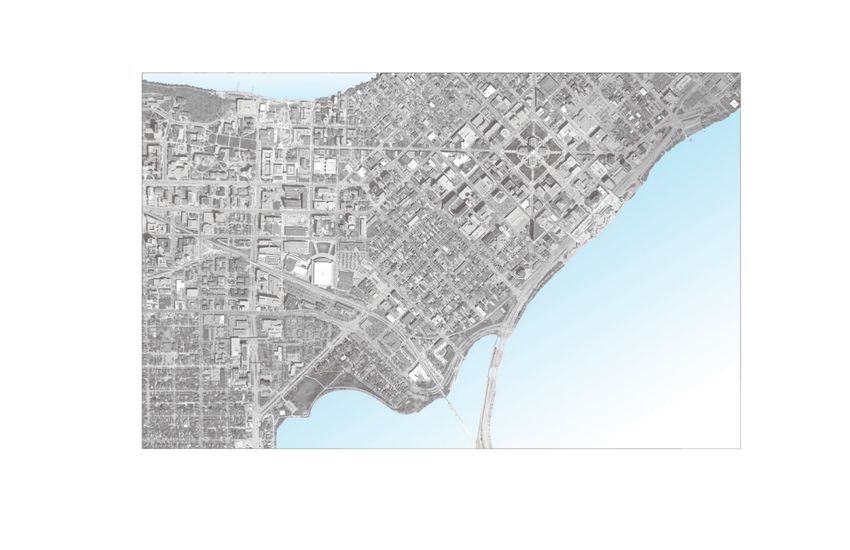
greening america’s Capitals is a U.S. environmental Protection
                                                               agency (ePa) program to help state capitals develop
                                                               an implementable vision of distinctive, environmentally
                                                               friendly neighborhoods that incorporate innovative
                                                               green infrastructure strategies. in collaboration with the U.s.
                                                               department of housing and Urban development (hUd)
                                                               and the U.s. department of transportation (dot) through
                                                               the Partnership for sustainable Communities, ePa provides
                                                               design assistance to help support sustainable communities
                                                               that protect the environment, economy, and public health
                                                               and to inspire state leaders to expand this work elsewhere.
                                                               greening america’s Capitals will help communities
                                                               consider ways to incorporate sustainable design strategies
                                                               into their planning and development to create and
                                                               enhance interesting, distinctive neighborhoods that have
                                                               multiple social, economic, and environmental benefits.

                                                               Madison, Wisconsin, was chosen in 2013 as one of four state
                                                               capital cities to receive this assistance, along with Lansing,
                                                               Michigan; Montpelier, Vermont; and olympia, Washington.

                                                               More information about greening america’s Capitals
                                                               is at www.epa.gov/smartgrowth/greencapitals.htm.

PhotograPhy Credits:
all photographs and graphics were either created by or the rights are owned by the Vireo and toole design group team.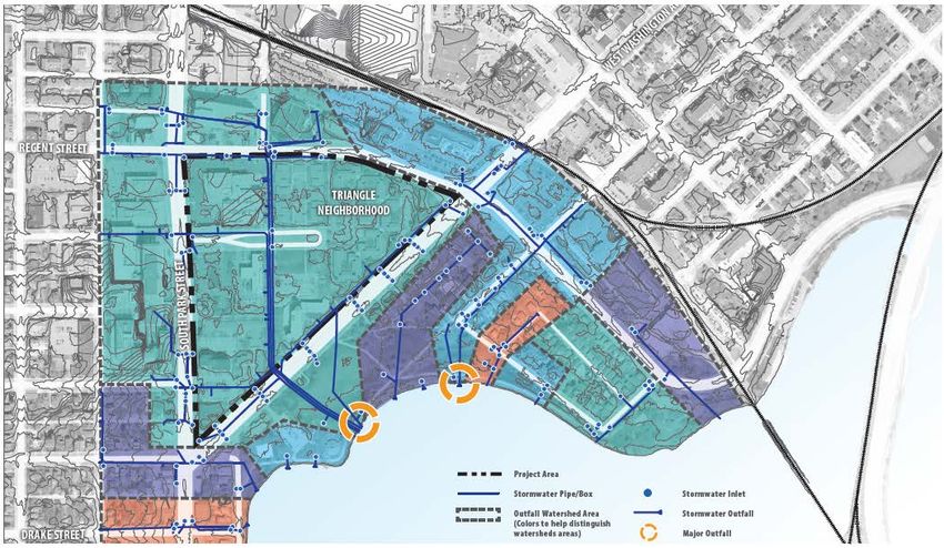
Acknowledgments
U.s. EnvironMEntal ProtEction agEncy                   contractor dEsign tEaM:
Clark Wilson, office of sustainable Communities        VIREO
Christopher Choi, ePa region 5                         stephen rhoades, Principal
city oF Madison staFF tEaM                             Matthew schoell-schafer, Project team Manager
                                                       robin Fordyce, associate designer
William Fruhling, Project Manager, Planning division
Natalie erdman, interim director of Planning and       TOOLE DESIGN GROUP, LLC
   Community and Economic Development (PCED)           tom huber, senior Planner
greg Fries, engineering division                       Kevin Luecke, senior Planner
Judy olson, Finance department                         ian Lockwood, Livable transportation engineer
agustin olvera, housing operations
anne Monks, Mayor’s office
Kay rutledge, Parks division
rebecca Cnare, Planning division
Jule stroick, Planning division
Kim alan, Police department
scott Langer, traffic engineering division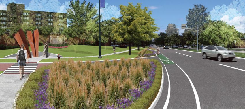
Table of Contents
ExEcUtivE sUMMary               iii
introdUction                     1
WorkshoP dEscriPtion             5
ProjEct arEa assEssMEnt          7
dEsign oPtions                  12
nExt stEPs, kEy PartnErs, and
  PotEntial FUnding soUrcEs     26
iii

Executive Summary
the city of Madison, Wisconsin, selected the triangle     the design options meet the community’s goals                  safely combine pedestrian, bicycle, and
neighborhood and Brittingham Park for a project           of making it easier for people of all abilities to get         vehicular traffic while providing space for
examining potential design improvements that make         around within the neighborhood as well as reach                green infrastructure and public art.
the neighborhood and park more accessible to              other parts of the city. they also provide strategies to
pedestrians and cyclists and clean the stormwater         improve water quality in Monona Bay by capturing           4) intersection of West Washington and regent
runoff before it reaches Lake Monona through              and cleansing stormwater while creating a distinctive         street:to create a defined gateway into
the use of more plants and trees. the Monona              and memorable entry to the neighborhood.                      the capitol district and enhance pedestrian
Bay neighborhood, adjoining Brittingham Park, was         the design options support the community and                  safety at this large intersection, the team's
also part of the initial site assessment. the project     city staff ’s efforts to provide more recreational            design used of a roundabout to slow traffic
area was chosen because of its close proximity to         activities such as community gatherings and boat              down and lessen the distance pedestrians
downtown, a major university, jobs, public transit,       rentals. these options are summarized as follows:             must to travel to cross the road.
and a lakefront park, as well as its diverse population                                                              5) Brittingham Bath house / Beach area:to
and potential municipal-institutional partnerships.       1) east Campus Mall extension:to create the
                                                             lake-to-lake connection and enhance the visual             maximize the opportunity this area has to
the area faces several challenges such as busy                                                                          further rejuvenate positive activities within the
roadways, wide and unsafe pedestrian crossings,              organization of the triangle neighborhood, the
                                                             team's design reconfigured the parking                     lake and neighborhood, the team's design
immigrant and disabled populations, lack of visual                                                                      would rebuild the bath house to include many
connection to the surrounding neighborhood                   lot and green space to create a defined central
                                                             open space along with a wide pedestrian way                sustainable features along with programming
and downtown, and environmental and water                                                                               features, such as heated outdoor spaces and
quality issues of Monona Bay. the city requested             connecting the existing campus mall to the
                                                             north with Brittingham Park to the south.                  concessions, that could extend the public
help from the U.s. environmental Protection                                                                             use of this facility into the winter.
agency’s (ePa) greening america’s Capitals                2) West Washington avenue:to improve
Program to explore design solutions that could               pedestrian safety, the team's design                    the report concludes with near-, mid-, and long-term
help protect water quality while improving quality           used of bump-outs and midblock crossings                actions that could catalyze improvements, as well
of life and bringing other community benefits.               to create safe pedestrian crossings and                 as potential funding sources for implementation.
                                                             pedestrian and bicycle paths to enhance the
in september 2014, the ePa project team held
                                                             multimodal aspect of West Washington.
a three-day workshop in the project area to
engage stakeholders, residents, and business              3) intersection of West Washington and south
owners. during the workshop, the project                     Park street:to create a defined gateway and
team developed multiple design options for five              improve pedestrian safety at this intersection, the
focus areas within the larger project area.                  team's design modified the intersection to safely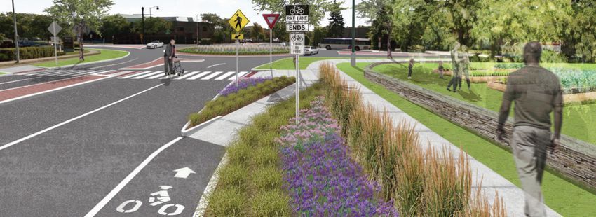
1

    Introduction
Madison, Wisconsin’s triangle neighborhood is an             community gardens for residents of the triangle           • green infrastructure includes a range of natural
ethnically and culturally diverse community near Lake        neighborhood. despite these efforts, the park is still      and built approaches, such as rain gardens,
Monona. in the 1960s, an urban renewal project               not well integrated into neighborhood residents’ lives.     bioswales, and permeable paving, that mimic
razed a traditional, ethnically and culturally diverse                                                                   natural systems by capturing and cleaning
neighborhood and replaced it with public housing             the city requested assistance from the U.s.                 stormwater and letting it infiltrate on site rather
buildings (one- and two-story townhomes and a high-          environmental Protection agency’s (ePa) greening            than directed into the storm sewer system
rise apartment building) and parking lots that left little   america’s Capitals Program to help develop                  and ultimately water bodies such as Lake
open space. the residents are mostly lower income.           ideas to improve the triangle neighborhood and              Monona. green infrastructure solutions can
a hospital, office building, and small grocery store are     Brittingham Park. ePa provided technical assistance         add greenery to streets, parking lots, and other
located on the western edge of the neighborhood.             through a team of consultants: Vireo and toole              paved areas, making them more appealing.1
                                                             design group, inc. the project team made an initial
the triangle neighborhood looks and feels like an            visit to Madison to meet with city staff and local        Prior to the workshop, city of Madison staff did
isolated island surrounded on all sides—south Park           stakeholders and collect data on the neighborhood         extensive outreach to residents to get their
street to the west, regent street to the north, and          and surrounding areas. the team then organized a          opinions on what the project’s goals should
West Washington avenue to the southeast—by                   three-day design workshop where a set of design           be. several themes emerged in the more
high-volume streets that act as barriers to the              options were created for the triangle neighborhood        than 400 responses city staff received:
neighborhood. the crossings at the three major               and Brittingham Park. City staff intends to use these     • improve the pedestrian crossings
intersections are very wide, with long distances             options to spur further planning for the triangle           at major intersections and the east
through vehicular traffic that pedestrians must              neighborhood and Brittingham Park. the options              Campus Mall so residents can get to
cross. these long distances make for difficult and           are primarily rooted in two design strategies:              places outside the neighborhood.
unsafe crossings, especially for the disabled, elderly,      complete streets and green infrastructure.
and those with children. Currently, the only way                                                                       • improve the water quality of Monona Bay to
for triangle neighborhood residents to get to                • Complete streets are streets designed to be               make it safer for swimming, fishing, and boating.
Brittingham Park safely is a narrow pedestrian bridge          safe and comfortable for everyone—drivers,              • improve pedestrian and bicycle connections within
that is not accessible per the standards outlined              pedestrians, bicyclists, and transit users. a             the neighborhood and to the rest of the city.
in the americans with disabilities act (ada).                  complete street allows people of all ages
                                                               and abilities to use streets safely by creating         • Provide more playgrounds, gathering
the neighborhood has only a few small, disparate,                                                                        spaces (incorporating barbeque
open spaces tucked between buildings, roads, and               pleasant sidewalks and safe crossings while
                                                               accommodating all types of transportation,                pits), and community gardens.
parking lots. Brittingham Park is an attractive but
underused park along Lake Monona. the city recently            including transit and bicycling.
reopened a park shelter that rents boats and installed                                                                 1 For more information on green infrastructure, visit ePa’s
                                                                                                                       green infrastructure website: www.epa.gov/greeninfrastructure.
2
HOWARD TEMIN E
LAKESHORE PA LAKE MENDOTA NU
TH
ET VE
RE O NA
ST GT
H AM S HI
N
GOR WA
ST S T
WE EA
UNIVERSITY OF STATE STREET WISCONSIN
WISCONSIN-MADISON EAST CAMPUS MALL
STATE CAPITOL
UNIVERSITY AVENUE
SOUTH HAMILTON STREET
SOU
THW
EST
COM
MUTE
R PA AIL
TH TR
N UE CIT
Y
E AL
KOHL N AV CA
PIT
O
CENTER N GT
HI
AS LAKE MONONA
UW HEALTH CLINIC
STW
WE
REGENT STREET Project Area
1
SOUTH PARK STREET
TRIANGLE 1 East Campus Mall Extension
NEIGHBORHOOD 4
2 West Washington Avenue
MADISON MEDICAL CENTER
Focus Areas
Intersection of West Washington
3 Avenue and South Park Street
MERITER 2 MONONA BAY
EN DRIVE
SOU
Intersection of West Washington
HOSPITAL NEIGHBORHOOD 4
TH
Avenue and Regent Street
WE
Brittingham Bath House and
ST
JOHN NOL
5 Beach Area
COM
5
MU
Pedestrian and Bicycle Path
3
TER
Park/Recreation Area
MONONA BAY
PAT
H
DRAKE STREET PEDESTRIAN BRIDGE
scale in feet 0 75 150 300 600
FIGURE 1 N
The project area is close to several significant community features, such as the state capitol and the University of Wisconsin-Madison, as well as many parks and trails.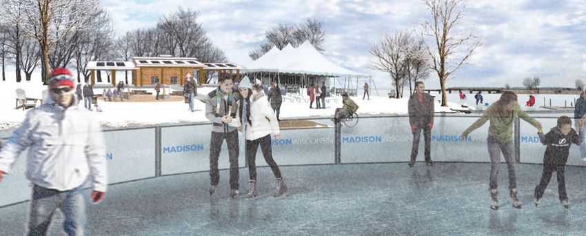
3

in addition, the city staff ’s goals included:       • Create neighborhood gathering places of a             2 | WEst Washington avEnUE
                                                       variety of sizes and activity levels. these could
• explore how to connect the existing east                                                                   West Washington avenue leads directly to the
                                                       include the integration of community gardens.
  Campus Mall path through the triangle                                                                      state capitol and is a four-lane divided street that
  neighborhood to complete the pedestrian and        • incorporate public art into placemaking,              carries over 20,000 cars per day. While it has had
  bicycle link between Madison’s two lakes.            sustainability measures, and neighborhood identity.   some improvements, such as bike lanes, it is still a
                                                     • establish a comprehensive approach to green           major barrier between Brittingham Park and the
• Protect water quality and reduce localized
                                                       design.                                               population of the triangle neighborhood. triangle
  flooding with green infrastructure.
                                                                                                             neighborhood residents voiced the need for
• Continue to revitalize Brittingham Park to make    the focus areas, indicated in Figure 1, include:
                                                                                                             more street-level crossings beyond the existing,
  it a destination for all residents and visitors.                                                           outdated pedestrian overpass (Figure 2). design
the design options illustrate how complete           1 | East caMPUs Mall ExtEnsion                          options include creating two additional at-grade
streets and green infrastructure strategies, such                                                            crossings spaced at a relatively similar distance to
as improved sidewalks, enhanced bike facilities,     Currently, the east Campus Mall is the primary          crossings found in the surrounding neighborhoods.
narrower traffic lanes, better road crossings,       north-south pedestrian connection in the University
native plantings, permeable pavements, and rain      of Wisconsin campus, extending from Lake Mendota
gardens, could be used in the five focus areas.      in the north to approximately regent street in
these strategies can be used to help meet the        the south (the northern boundary of the triangle
goals of city staff identified at the beginning      neighborhood). extending the east Campus Mall
of the project, which include                        south through the project area would create a direct
(excerpt from the city’s proposal to the ePa):       lake-to-lake pedestrian and bicycle connection.
                                                     in addition to the new connection between the
• enhance connections to adjacent areas to           two lakes, triangle neighborhood residents would
  allow residents to be “full city users.”           have easier access to the university’s resources.
• Create safe, comfortable, and walkable streets
  and walkways within the neighborhood.
• integrate Brittingham Park, Brittingham Beach,
  the Monona Bay shoreline, and the natural
  environment into the fabric of the neighborhood.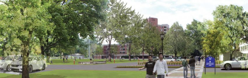
4

3 | intErsEction oF WEst Washington                      4 | intErsEction oF WEst Washington                              5 | BrittinghaM Bath hoUsE
avEnUE and soUth Park strEEt                             avEnUE and rEgEnt strEEt                                         and BEach arEa
Madison residents consider the intersection of           the intersection of regent street and West                       although it is visible across Monona Bay from
south Park street and West Washington avenue             Washington avenue is another important gateway                   John Nolen drive, this focus area is in a relatively
to be the gateway to downtown and the state              to the state capitol, as well as to the university.              remote part of the park. it has a park shelter that
capitol. the intersection is difficult for pedestrians   design options explored how to make the                          was recently converted to a small business renting
and cyclists to cross because of its size and            crossing safer for pedestrians and bicyclists, as well           small, non-motorized boats and an underused
configuration. design options explore how this           as replacing impervious surfaces with attractive                 swimming beach. design options for this location
intersection could be made safer for pedestrians         landscaping that could absorb stormwater runoff.                 could enhance current revitalization efforts and make
and cyclists and could create a welcoming                                                                                 the area more attractive for year-round activity.
gateway to the downtown and state capitol.

                                                         FIGurE 2
                                                         The existing pedestrian bridge is underused for several reasons: it is not ADA accessible, it becomes dangerous during icy
                                                         or slippery conditions, and it does not connect to sidewalks and trails on the park side.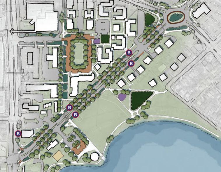
5

Workshop Description
as part of the greening america’s Capitals Program,    three public meetings were held—one on the
the design team, ePa, and city staff organized a       first evening of the workshop, one working
three-day design workshop. this intensive event        session/open house on the second day, and one
brought together the public, stakeholders, subject     on the final day. the public involvement activities
matter experts such as public health officials, and    allowed the design team and city staff to revisit
various city departments to discuss opportunities,     and refine the initial project goals. Participants
constraints, and ideas to develop design options       in the meetings generally agreed with the initial
that address the community’s wants and needs.          project goals but added to them the following:

during the initial site visit, the design team met     • Make road crossings safer for everyone,
with various city and neighborhood stakeholders          especially the elderly, young, and disabled.
and held a visioning session to elaborate everyone’s
hopes and desires for the neighborhood. Based          • ensure that people with disabilities can easily
on this visioning session, the dominant points of        access Brittingham Park and its recreational uses.
discussion focused on elements of transportation,      • Provide shelters at bus stops to protect
environmental sustainability, quality of life, and       transit riders from the elements.
institutional and commercial interests.
                                                       • ensure that additional bicycle traffic through
                                                         the neighborhood (as a result of extending
                                                         the east Campus Mall) does not put elderly,
                                                         disabled, and young people at risk.

                                                       • Provide programs and facilities so the
                                                         park can be more used in the winter.

                                                       • Consider how triangle neighborhood residents
                                                         could help maintain any new planting beds and
                                                         rain gardens (in addition to community gardening
                                                         plots) to help keep maintenance costs low.
6
FIGurE 3 FIGurE 4 FIGurE 5
During the three-day workshop, the design team prepared, Design options were discussed with neighborhood residents Throughout the process, stakeholders, including city staff,
reviewed, and revised design option sketches based on and other members of the public, including members of the worked with the design team to craft design options.
participants’ input. local Hmong community, in three public meetings held
during the workshop.7
Project Area Assessment
the project area includes the triangle neighborhood, residents in the triangle neighborhood, as with the project area’s assets include its sense of
part of the Monona Bay neighborhood, and other low-income neighborhoods where residents community, proximity to amenities, and existing
Brittingham Park. the neighborhoods and park are on rely on walking to get around, are particularly transportation networks. its challenges include
the western edge of downtown Madison, directly susceptible to the effects of climate change. a 2002 environmental degradation, historical disinvestment,
south of the University of Wisconsin, and near Climate Protection Plan prepared for the city of mobility, and accessibility.
several health care facilities, such as Meriter hospital Madison notes that Wisconsin’s climate is projected
and University of Wisconsin health. to change significantly. Based on projections, by 2100,
temperatures in Wisconsin could increase by about
the triangle neighborhood has a variety of rent- 4 degrees Fahrenheit. the plan states, “small
subsidized housing, medical office buildings, and a changes in temperature like this can dramatically alter
small asian grocery store. Many of the housing units the climate...Precipitation is predicted to increase
in the neighborhood are occupied by a wide variety by 15-20%. the frequency of extreme hot days
of immigrant populations, seniors, and those with in summer is expected to increase along with the
some form of disability. the subsidized housing is general warming trend. higher temperatures and
managed by the Community development authority increased frequency of heat waves could increase
or the Bayview Foundation, a private nonprofit the number of heat-related deaths and the incidence
corporation. of heat-related illnesses. Wisconsin, with its irregular,
the project area has approximately 1,045 residents, intense heat waves, seems somewhat susceptible…
of which 50 percent are identified as a racial We can already see possible impacts of warming in
minority, according to the 2010 census. the median Madison, including Lake Mendota freezing later and
household income for neighborhood residents is for shorter periods than in the past.” 2
$12,276, compared to $52,550 for the city, and 37
percent of households do not own a car. according
to the Community development authority, 87
percent of residents in the neighborhood live with
some sort of disability.
2 somers, Jane. “Climate Protection Plan.” City of
Madison engineering divison. 2002. Page 9.8
assEts
Sense of community Proximity to amenities Existing transportation networks
residents see their neighborhood as very tight-knit, residents appreciate the close proximity to downtown, the triangle neighborhood sits along a major public
and they value and celebrate diversity. Within University of Wisconsin, Brittingham Park, and other transit route, with several bus stops on West
the Bayview housing development, there are cultural destinations. Many of these destinations are Washington avenue. Madison has an extensive
over a dozen different immigrant populations, within walking distance, although currently the walk is network of bicycle routes, with a major route
with hmong being the most prevalent. difficult because of the busy streets surrounding the passing through Brittingham Park that extends
neighborhood. the neighborhood has one store, asian to downtown and to the south and west. this
Midway Foods (Figure 7), and across regent street is a route connects to other regional routes.
retail strip center that houses a variety of businesses,
including a Panera Bread, a Fedex Print and
shipping Center, and a credit union, to name a few.
FIGurE 6 FIGurE 7
Two Triangle neighborhood residents enjoying a day in Brittingham Park, catching butterflies, Asian Midway Foods, the only grocery store in the Triangle neighborhood, is a key business
visiting the garden, and walking on trails around Monona Bay. with healthy food choices within walking distance of much of the neighborhood.9
HOWARD TEMIN
LAKESHORE PA
TH
LAKE MENDOTA NU
E
ET VE
RE NA
ST TO
M
HA I NG
GOR A SH
ST TW
WE EA
S
STATE STREET WISCONSIN
UNIVERSITY OF
WISCONSIN-MADISON STATE CAPITOL
UNIVERSITY AVENUE
SOUTH HAMILTON STREET
SOU
THW
EST
COM
MUTE
R PA AIL LAKE MONONA
TH Y TR
L CIT
N UE ITA
KOHL VE CA
P
CENTER ONA
NGT
HI
Project Area
AS
STW B-Cycle Station
WE Metro Bus Route
REGENT STREET
SOUTH PARK STREET
TRIANGLE Metro Bus Stop With Shelter
NEIGHBORHOOD
Metro Bus Stop Without Shelter
Pedestrian and Bic ycle Path
MERITER EN DRIVE
SOU
MONONA BAY Bike Route (On Street)
HOSPITAL NEIGHBORHOOD
TH
BRITTINGHAM Bike Lane
WE
PARK
ST
JOHN NOL
Bike Boulevard
COM
Potential Passenger Rail Stop
MU
TE
Park/Recreation Area
RP
MONONA BAY
ATH
DRAKE STREET ASIAN MIDWAY FOODS
scale in feet 0 75 150 300 600
FIGURE 8 N
Some of the most important components for the neighborhood include the Metro stops along West Washington, which are
used by many residents as the primary mode of transportation.10
challEngEs
Environmental degradation
Madison’s growth pattern has significantly affected the
ecological health of the two lakes. historically, Monona Bay
was a low marsh/wetland that was dredged as the city grew.
While this neighborhood has not experienced the localized
flooding that other parts of the city have, the runoff, which
is full of pollutants, including phosphorus and road salts,
make the bay’s water too dirty for recreation. a significant
amount of land drains into the bay (Figure 11), including
roads and parking lots, which contributes to its degradation.
Mobility and accessibility
although the neighborhood is centrally located, FIGurE 9
it is not easy to get into and out of, especially for View of Parkside Apartments demonstrating a typical arrangement of housing within the Triangle
people with disabilities, because of the high traffic neighborhood, which focuses front doors inward towards the parking lot.
volume on the surrounding streets. the pedestrian
bridge that connects the triangle neighborhood
with the park is not ada-accessible and is
seldom used, leaving many to negotiate the street
traffic rather than climb the overpass to reach the
park.
FIGurE 10
Historic neighborhood homes were replaced with taller buildings in the 1960s.11
scale in feet 0 75 150 300 600
FIGurE 11 N
This map shows the Triangle neighborhood’s stormwater infrastructure. The neighborhood drains into the lake from one outfall
located next to the park shelter in Brittingham Park.12
Design Options
the design options respond to the project goals
and the project area’s challenges and assets. the city
of Madison wants to use green infrastructure and regeNt street
complete streets to initiate the planning process in the
underserved triangle neighborhood. the focus areas 4
were selected to improve existing conditions of the
BraXtoN PLaCe
neighborhood and to help reconnect the fragmented
1
Pr
neighborhood with the surrounding community. Ue
o
eN
Ud
aV
Fit
getting around inside the neighborhood and to N
st
o
gt 2
re
other areas of the city is the triangle neighborhood N
et
hi
s ParK street
residents’ most pressing concern. Many residents are as
W
t
immigrants, seniors, and people with varying degrees of es
W
disability, many of whom do not have vehicles and get
around by walking, biking, and public transportation. MoNoNa Bay
3 5
the design options show how implementing green
infrastructure and complete streets could improve
residents’ transportation options. traffic calming,
rain gardens, and safer streets and pedestrian scale in feet 0 250 500 1000
FIGurE 12 FOCuS ArEAS: N
crossings can make it easier for residents to move
1. East Campus Mall Extension
around the neighborhood and the surrounding
2. West Washington Avenue
community. green infrastructure features can 3. Intersection of West Washington Avenue and South Park Street
capture and clean stormwater, improving the quality 4. Intersection of West Washington Avenue and regent Street
of the water flowing into Monona Bay. green 5. Brittingham Bath House and Beach Area
infrastructure elements can also help cool ambient
air temperatures, which can help keep streets more
comfortable on hot days, and handle increased
runoff from the heavier rainfalls that are expected to
happen more frequently as the climate changes.S PARK ST
N
O
GT
N
13 HI
LEGEND 1. Central green AS
W
REGENT
Focus Area 1 2. Bioswale W N
View location
(Figures 14 and 15) 3. Signalized crossing at Regent Street BRAXTON
EAST CAMPUS MALL EXTENSION Section location 4. Relocated playground
(Figure 16) 5. Expanded community gardens CHANDLER
Goals achieved with design option 6. Landscape buffer/bioswale VILAS
7. Parking around central green PLAN KEY
• Enhance connections to adjacent areas to
allow residents to be “full city users.”
REGENT STREET 3
EAST C AMPUS MALL
• Create safe, comfortable, and walkable streets
and walkways within the neighborhood.
• Create neighborhood gathering places of
a variety of sizes and activity levels. UW
HEALTH GAY BRAXTON BAY VIEW
• Incorporate public art into placemaking, CLINIC HOUSING FOUNDATION
sustainability measures, and neighborhood identity. 6
• Establish a comprehensive approach to green design. COMMUNITY
CENTER
The design option reconfigures the existing green
space and parking lots to create a larger, central green
space while keeping the same number of parking BRAXTON PLACE 5
4
spaces (Figure 13). It also enhances the existing
2
development, provides a natural sense of wayfinding
(by providing a clearly identifiable neighborhood center),
6 1 7
and improves neighborhood identity. Extending SELECT
the mall and installing a safer, signalized crossing at SPECIALTY UE
E N
AV
SOUTH PARK STREET
HOSPITAL
Regent Street would make it easier for residents N
O
to get to employment and education opportunities 7 GT
H IN
on the other side of Regent Street. The signalized AS
EXISTING PARKING AREA W
crossings could be similar to those found in other ES
T
W
locations along the East Campus Mall. Because BRITTINGHAM
the mall alignment falls along the main stormwater APARTMENTS
scale in feet 0 50 100 200
drainage path and the location of the storm inlets, FIGURE 13 N
Plan view of central green and East Campus Mall extension and central green improvements. Gardening is a positive activity already
happening in the neighborhood, and could be expanded near the new play equipment to accommodate additional plots for residents.14 bioswales and rain gardens can be incorporated to capture and treat stormwater before it gets into the sewer system and, ultimately, Lake Monona. residents of apartments along the potential mall extension are concerned about privacy. a landscape buffer could help screen apartment windows to give privacy to those living next to the path. a landscape buffer is a strip of plantings that are tall enough to obscure views of the windows beyond, but not tall enough to create a hiding place. in addition to the landscape FIGurE 14 buffer, enhanced signs and lighting will help Existing view looking south to Brittingham Apartments from Braxton Place. Currently, finding one’s way around the delineate the open space. residents were also neighborhood is difficult because walkways have few signs and poor connections. concerned about how fast bicyclists might go along the path and the potential risk to pedestrians. FIGurE 15 Design option view looking south to Brittingham Apartments from Braxton Place. The design adds a bioswale next to the path and signs that guide people through the area. The open play field creates a better defined open space for the residents while preserving many of the large trees. Additional signs could be incorporated to create clear connections through the neighborhood.
15

 initially, the path can be a small pedestrian walk that       Figure 16 shows a cross section through the East               feet wide) to give users enough room to avoid any
 restricts bicycle traffic to minimize conflicts. But,         Campus Mall and community green space that                     conflicts between bicyclists and elderly or disabled
 over time, the Community development authority                uses green infrastructure to create a defined and              residents using the path. Lighting such as pedestrian-scale
 intends to redevelop and improve the housing in the           attractive edge for the central green space. in                pole lights would enhance safety and security along
 neighborhood. When the buildings are reconfigured,            addition to maintaining a strong edge for vehicular            the path. Permeable pavement could be used
 the mall extension could be widened to at least               traffic and parking, the bioswale would create a               in parking and driving lanes to reduce ponding,
 12 feet wide, which will help accommodate                     visual buffer to help separate the neighborhood                absorb and filter stormwater, and add aesthetic
 both pedestrian and bicycle traffic safely.                   activities within the central green space from the             elements. Preserving the existing mature tree canopy
                                                               bicycle traffic that might use the mall. the width of          would shade the east Campus Mall extension.
                                                               the East Campus Mall is also critical (at least 12

                                                 12’                 15’                18’ - 20’ permeable                  20’ - 24’                        central green space
                                            e campus mall         bioswale               pavement parking                   drive lane
                                                                                                                                              scale in feet   0     5     10         20
 FIGurE 16
 Section of the design concept showing bioswales at the central green next to parking paved with permeable pavement. The bioswale would protect water quality and provide a buffer
 between people using the mall to get to the lakes and the residents using the central green space.
S PARK ST
N
O
GT
N
HI 16
AS
lEgEnd REGENT
W
Focus Area 2
W N
Midblock crossing 1. Parking and farmer’s BRAXTON
location market
WEst Washington avEnUE
Bus stop location 2. Park shelter CHANDLER
View location 3. Existing pedestrian
Goals achieved with design option: (Figures 18 and 19)
VILAS
bridge
• enhance connections to adjacent areas to Section location PLAN KEY
(Figures 20, 21, and 22)
allow residents to be “full city users.”
• Create safe, comfortable, and walkable streets UW heaLth gay BraXtoN Bay VieW
and walkways within the neighborhood. CLiNiC hoUsiNg FoUNdatioN
• establish a comprehensive approach to green CoMMUNity
CeNter
design.
BraXtoN PLaCe
the design option for this focus area makes
the crossing of West Washington avenue safer seLeCt
for bicyclists, pedestrians, drivers, and transit sPeCiaLty
hosPitaL
users. the existing bike lane would be removed soUth ParK street
and replaced by a separated bike path that
reduces conflicts between bicyclists and cars. BrittiNghaM
aPartMeNts
the underused, existing pedestrian bridge
would remain, but enhanced crossings at-grade
would be added, as was desired by residents
in the workshop. the design concept creates two 3
midblock crossings, which both calms traffic and
gives pedestrians a refuge island as they cross this
wide road. at each of the bump-outs, a covered
bus shelter could protect transit users from the
elements. along the parking areas and in the MoNoNa Bay
refuge islands at the midblock crossings, pervious 1
pavers could capture and treat stormwater. 2
scale in feet 0 50 100 200
FIGurE 17 N
Design option for West Washington Avenue.17
FIGurE 18
Existing view looking northeast along West
Washington Avenue toward the capitol
building. As noted at the workshop, crossing
West Washington Avenue at grade is unsafe,
and the street currently has no identified
pedestrian crossing.
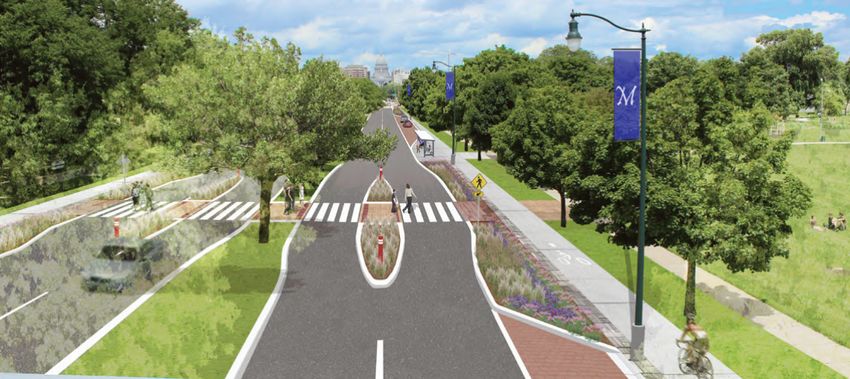
FIGurE 19
Design option view looking northeast along West Washington Avenue toward the capitol building. The midblock crossing creates a safe refuge for pedestrians in the central median, as well
as the pedestrian refuge island added in the laneways in each direction. A covered bus stop shelters transit users. Clearly delineating paths for cyclists and pedestrians will help limit conflict
between them. Enhanced landscaping in these areas will help create the perception of comfort for pedestrians and improve the visual aesthetics of the road.S PARK ST
N
O
GT
N
HI 18
AS
lEgEnd REGENT
W
W N
1. Bus shelter 4. Bollard BRAXTON
2. Bike path 5. Detectable warning
3. Pervious pavers for pavers CHANDLER
parking area 6. Landscape area VILAS
Plan
PLAN kEy
KEY
2
1 6
3
4
6 5
scale in feet 0 5 10 20 40
FIGurE 20 N
Enlarged view of the West Washington Avenue midblock crossing and refuge islands. Bollards at the nose of the islands further help protect pedestrians and
give snow plows a landmark to avoid during plowing. Detectable warning pavers are a textured pavement letting pedestrians with visual or other disabilities
know they are entering the roadway.19
FIGurE 21
Existing section of West
Washington Avenue looking
northeast.
side turF bike bike parking turF side
walk landscape parking lane drive lane drive lane median drive lane drive lane lane landscape walk
FIGurE 22
Section of design option
showing of West Washington
Avenue looking northeast.
side landscape bike parking drive lane drive lane median drive lane drive lane parking bike landscape side
walk Zone patH patH Zone walk
bus sHelter bus sHelter
landscape landscapeS PARK ST
N
O
GT
N
HI 20
AS
W
REGENT
Focus Area 3
W N
lEgEnd
BRAXTON
View location
intErsEction oF WEst Washington avEnUE and s Park strEEt (Figures 24 and 25)
CHANDLER
1. Public art opportunity
Goals achieved with design option: VILAS
2. Bioswale/landscape
• enhance connections to adjacent areas to area PLAN KEY
allow residents to be “full city users.” 3. raised crosswalk with
colored pavement
• Create safe, comfortable, and walkable streets 4. Bike path
and walkways within the neighborhood.
• incorporate public art into placemaking, asiaN Ue
N
MidWay Foods aVe
sustainability measures, and neighborhood identity. N
o
gt
• establish a comprehensive approach to green N
hi
4 as
design. W
t
es
W
the design option for this intersection improves safety 1
for bicyclists and creates spaces for green infrastructure 2
and public art. at the intersection, the bike lane 3
divides; one transitions into the vehicular traffic, and the
other transitions into the sidewalk. this allows
experienced riders to safely become part of the 4
vehicular traffic as they head north or south on
Park street. Less-experienced riders could choose to
stay on the sidewalk and cross the intersection with
pedestrians. reducing the width of the southbound,
right-turn lane from West Washington avenue
3
onto south Park street and enlarging the pedestrian
soUth ParK street
refuge island creates more green space. the enlarged
pedestrian refuge would make the crossing safer, letting
people feel more confident about crossing into and
out of the triangle neighborhood as well as providing
a space for public art or green infrastructure. For
vehicular movement, the northernmost westbound scale in feet 0 25 50 100
FIGurE 23 N
land on West Washington avenue is a through- Design concept for the intersection of West Washington Avenue and South Park Street.
lane to accommodate westbound traffic.21
FIGURE 24
Existing view looking northeast along West Washington
Avenue from South Park Street toward the capitol building.
Currently, pedestrian crosswalks are not visible to turning
cars.
FIGURE 25
View of design option looking northeast along West Washington Avenue from South Park Street toward the capitol building. Bump-outs and landscaping help delineate the bike lanes and
provide a safer crossing for pedestrians. Public art could help make this intersection a gateway into the capitol.S PARK ST
N
O
GT
N
HI 22
AS
W
lEgEnd REGENT
Focus Area 4
W N
View location BRAXTON
intErsEction oF WEst Washington avEnUE and rEgEnt strEEt (Figures 27 and 28)
1. Community gardens CHANDLER
Goals achieved with design option: 2. Bioswale/landscape VILAS
area
• enhance connections to adjacent areas to 3. Low stone wall
PLAN KEY
allow residents to be “full city users.” 4. Public art opportunity
• Create safe, comfortable, and walkable streets 5. Permeable paver edge
and walkways within the neighborhood.
• incorporate public art into placemaking, e
aV
sustainability measures, and neighborhood identity. N
to
g
iN
• establish a comprehensive approach to green as
h
reg
design. eN W
ts t
tre es
et W
the design option for this focus area incorporates groUP heaLth
a roundabout into the intersection of West CooPeratiVe
Washington avenue and regent/Proudfit streets. 3
5
in a roundabout, pedestrian crossings are made
easier because a pedestrian need only watch for
BayVieW aPartMeNts
traffic coming from one direction at a time because
1
there are pedestrian islands separating travel lanes 4
(oFF MaP)
4
on each approach. traffic speed going through the
roundabout is slow, which creates a less intimidating
environment for pedestrians as well. the elimination
of turn lanes leading up to the roundabout narrows
the crossing distances and creates space for 2
Pr
o
other uses, including landscaping that can capture
Ud
Fit
stormwater runoff. these landscaped areas can
st
r ee
also be places to store the snow that is plowed
t
off the streets in the winter. the roundabout also
provides a visual gateway to the capitol to the ParK VieW
aPartMeNts
north. the bike lanes transition from the drive lane scale in feet 0 25 50 100
to the separated path along West Washington. FIGurE 26 N
Design option of the intersection of West Washington Avenue and regent/Proudfit streets.23
FIGURE 27
Existing view looking east along Regent
Street to the intersection of West
Around the perimeter of the roundabout could be a 5- Washington Avenue and Regent/Proudfit
to 10-foot-wide strip of permeable pavers. This strip of streets. Navigating this heavily travelled,
pavers can be used to capture stormwater, but more wide intersection as a pedestrian,
importantly, during snow removal, the snow can be piled bicyclist, or driver is difficult and unsafe,
particularly for disabled residents.
onto the strip, and as it melts, salt-laden water is cleaned
as it soaks through the pavers. On the corner next to the
Bayview Apartments, a portion of the existing landscaping
would be converted to community gardens to fulfill
residents’ desire for more gardening plots. Replacing
the existing chain-link fence at this corner with a small
stone wall would be more attractive and would address
residents’ concern about children’s safety next to a busy
road, especially if garden plots are added to the corner.
FIGURE 28
Design option view looking east along Regent Street to the intersection of West Washington Avenue and Regent/Proudfit streets. The community garden and stone wall can create a sense of
community. The roundabout could provide a visual gateway to the capitol while capturing and treating stormwater runoff.S PARK ST
N
O
GT
N
HI 24
AS
W
lEgEnd REGENT
Focus Area 5
W N
View location BRAXTON
(Figures 30 and 31)
BrittinghaM Bath hoUsE and BEach arEa
1. renovated bath house CHANDLER
Goals achieved with design option: 2. Bioswale VILAS
3. Gathering area
• Create safe, comfortable, and walkable streets 4. Accessible boat dock PLAN KEY
and walkways within the neighborhood. 5. Boat storage
• integrate Brittingham Park, Brittingham Beach, 6. Expanded deck area
the Monona Bay shoreline, and the natural 7. Trail crossing
environment into the fabric of the neighborhood.
Pr
o
• Create neighborhood gathering places of Ud
Fit
a variety of sizes and activity levels. st 7
re
et
• establish a comprehensive approach to green
design.
the design option for this focus area shows
how redevelopment of the area around the old
bath house could incorporate environmentally 2
sustainable practices, such as a photovoltaic system
to supply power for heat and hot water. adding
environmentally friendly features would help bolster 1
the recent progress in turning the bath house into
a neighborhood amenity. Currently, the facility 6
3
closes during the winter despite neighborhood 5
residents’ desire to have year-round activity. the
bath house could be renovated and programmed MoNoNa Bay
to facilitate winter uses, which might include an
expanded gathering space with warming elements
(which could be a simple fire ring or gas heaters 4
with seating around), concessions for ice fishers, or
other activities such as ice skating. in addition to the
enhanced winter programming, the deck could be
expanded with additional seating, and the accessible FIGurE 29 N
Design option of new park amenities and structures, including rain gardens, safer crossing of Proudfit Street, more seating
at the water’s edge, and a warming feature.25
FIGurE 30
Existing view looking northeast to the
Brittingham bath house and beach.
boat dock (which is a part of the Brittingham Park recent programming and activities in the
Master Plan) could be built at this location to area have made this area of the park feel
expand the users who can take advantage of the safer, which is encouraging more use of
boating activities. Finally, building off of the the park.
existing rain gardens and bioswales that have educational
signage, the environmentally sustainable features
built into the new bath house could demonstrate
and educate people about the importance and
benefits of green infrastructure as well as improve
perceptions of the neighborhood and park.
FIGurE 31
Design option view looking northeast to the Brittingham bath house and beach. Creating warming spots (such as outdoor gas heaters with seating) and winter concessions such as ice-fishing
supplies or ice skating rentals could encourage year-round activity. The renovated bath house could include environmentally sustainable features such as photovoltaics and recycled materials.26
Next Steps, Key Partners, and Potential Funding Sources
introdUction • Continue to improve access to the park’s West Washington avenue and regent street,
recreational amenities for people with disabilities. and pedestrian improvements at West
the design options presented in this report can
• explore options for continuing the farmers market Washington avenue and south Park street.
spur further interest and investment in the triangle
neighborhood and Brittingham Park and catalyze and operating it for three seasons of the year. Mid-tErM actions
future improvements. this section discusses • Consider adding public art in Brittingham Park Mid-term (three to five years) actions include
potential near-, mid-, and long-term steps, key to raise awareness of and celebrate the diverse opportunities, built on the successes of the
community partners, and funding sources identified cultures in surrounding neighborhoods. short-term steps, to invest in design and
and discussed during the design workshop that
• expand the Brittingham gardens in the park. planning that can set the stage for larger
can help the city of Madison achieve its goals.
Because of the popularity of the existing gardens, infrastructure and transportation investments.
short-tErM actions the Parks division could reach out to current
gardeners and non-gardeners and explore • develop design and engineering plans for
short-term steps (one to two years) include intersection modifications for improved
feasible expansion plans that would serve the
activities that could continue to involve pedestrian and bicycle access in two
gardeners but not restrict other recreational uses
the neighborhood residents and partners, locations: West Washington avenue and
in the park. one suggestion for improvements
surrounding institutions, and the city. regent/Proudfit streets, and south Park
to the existing gardens was to put some of the
beds into raised planters so that gardeners with street and West Washington avenue.
• Begin the process of including street crossings
in the capital plan, undertake a traffic analysis, disabilities could more easily access the plots. • Consider a larger redevelopment plan for the
and reach out to residents to identify locations. • Construct mid block crossings on West triangle neighborhood, specifically Brittingham
Washington avenue for better access to apartments, Karabis apartments, Parkside
• involve triangle and Monona Bay neighborhood
transit stops and Brittingham Park. apartments, and gay Braxton apartments.
residents when programming and designing
the Community development authority
future improvements to Brittingham Park. • develop design plans and budgets for and Planning division could lead the plan and
Many of the residents consider Brittingham pedestrian and bicycle access to regent partner with Meriter hospital, University of
Park to be their community park and street at the east Campus Mall extension. Wisconsin health, and the Bayview Foundation.
could help with basic maintenance.
• establish budgets for design and engineering this plan could consider improving the central
• translate online registration forms for picnic for the major improvements, including West green space as an organizing element for the
shelter rental into additional languages (spanish Washington and the east and west gateway neighborhood, extending the east Campus
and hmong were specifically mentioned in the intersections. these improvements could Mall across the neighborhood, and introducing
workshop) to encourage triangle neighborhood include the mid block crossings along West green solutions for stormwater management.
residents to use the park facilities more often. Washington avenue, the roundabout at27
• expand the farmers market to possibly kEy PartnErs • The Parks Division controls Brittingham Park
include produce grown and sold by the and its recreational amenities such as the
in order to help move many of these projects forward
residents of the neighborhood. shelter house, sand volleyball, walking and
to construction, it is vital that the city enlists as many
biking trails, places for public art, community
different partners to help garner the necessary
long-tErM actions gardens, playgrounds, the lake, and the bath
funding and community support. the following is a
in the long term (five to 10 years), the city house. it has installed several rain gardens, which
list of partners that could be part of the process as
could investigate the construction of larger help protect water quality in Monona Bay.
the city progresses with the planning and
infrastructure improvements, as well as redeveloping implementation of improvements in the project area. • The Police Department provides social
housing in the triangle neighborhood. support services to many area residents.
Municipal Partners the community police officer organizes the
• incorporate the larger redevelopment • The Department of Planning and Community residents to operate the community gardens
plan into the city’s comprehensive plan and Economic Development works with and farmers market in Brittingham Park.
and other relevant city plans. elected officials, neighborhoods, businesses,
• Public Health Madison and Dane County work
• Construct intersection modifications for and nonprofit groups on quality-of-life
with the triangle neighborhood and businesses
improved pedestrian and bicycle access in issues such as improved water quality and
to “enhance, protect, and promote the health
two locations: West Washington avenue neighborhood accessibility within the city.
of the environment and the well-being of all
and regent/Proudfit streets, and south Park • The Community Development Authority holds much people.” 3 While not directly affecting built
street and West Washington avenue. of the land in the triangle neighborhood that projects, Public health Madison and dane County
• Construct improved pedestrian and could be modified to include green solutions and can be a vocal advocate for the residents and
bicycle access to regent street at the enhanced neighborhood access to economic, could help influence city leadership in favor
east Campus Mall extension. cultural, and recreational resources of the city. of projects that can improve public health.
• improve existing housing based upon the larger • The Engineering Division maintains and • The Madison Metropolitan Sewage District
redevelopment plan, and construct the central upgrades utilities and infrastructure and could owns and operates the large pump station
green space, the east Campus Mall extension, and include improvements such as adding green building in Brittingham Park along West
green solutions for stormwater management. infrastructure to improve water quality in future Washington avenue. It could provide
stormwater projects in the neighborhood. guidance for looking into opportunities,
• Further study and design the conversion
of the bath house in Brittingham • The Traffic Engineering Division provides as desired by the city, to better integrate
Park to allow year-round use. guidance and requirements for transportation this facility into the park, such as providing
improvements within city-owned rights of shade structures and a covered bus stop.
way and can influence improvements for
pedestrian and bicycle access and safety in
the neighborhood and along nearby streets.
3 "About Us - Public Health Madison & Dane County"
http://www.publichealthmdc.com/about/28 Institutional Partners • The Bayview Foundation, Inc. is a 501(c)(3) • Meriter Hospital is a large institution that nonprofit corporation that owns and operates occupies much of the west side of south Park Bayview townhouses and Bayview international street. it provides health care services to many Center for education and the arts. it provides of the triangle neighborhood residents. many support services and educational and • University of Wisconsin Health occupies the enrichment programs for the residents and northwest corner of the triangle neighborhood. operates the Bayview Community Center. When it considers improvements to its campus, • Other neighborhood partners that participated in it could ensure those improvements maintain the greening america’s Capitals project and are pedestrian and bicycle access and protect important in future planning and implementation water quality through green infrastructure. efforts include the Monona Bay Neighborhood • University of Wisconsin is an important partner in association, Friends of Monona Bay, surrounding the extension of east Campus Mall, stormwater property owners, service providers, and other management, and other potential improvements community groups and organizations. within and adjacent to the project area. Neighborhood Partners • Brittingham and Gay Braxton Apartments are controlled by the Community development authority. Both apartment complexes are designated for residents who are 50 years of age or older and have disabilities. Many of their residents would benefit from improved pedestrian access to the public spaces and surrounding businesses. • Karabis and Parkside Apartments are also Community development authority partners and provide affordable homes to triangle neighborhood residents. Many of their residents would benefit from improved pedestrian access to the public spaces and surrounding businesses.
29

     POTENTIAL FUNDING SOURCES                                EPA office of Water has many grants and funding            Local Funding and Assistance
                                                              sources for:
 Federal Funding                                                                                                         Capital Area Regional Planning Commission (CARPC)
                                                              Clean Water projects to improve water quality,
                         Act Section 319 grants are                                                                      The commission is the regional planning and area-
                                                              renew wastewater, and support local economies.
     directed to demonstration projects that reduce                                                                      wide water quality management planning entity for
                                                              Section106 Water Pollution Control to establish
     nonpoint source pollution. Green infrastructure                                                                     the Dane County region. The commission prepares
                                                              ongoing water pollution control program.
     elements of the design options can be eligible                                                                      and adopts a master plan for the region and
                                                              Targeted Watersheds to encourage community-based
     for funding through this program. For more                                                                          maintains an area wide water quality management
                                                              approaches to protect and restore watersheds. For more
     information go to www.deq.mt.gov/wqinfo/                                                                            planning process for the region’s water resources.
                                                              information visit www.water.epa.gov/grants_funding
     nonpoint/319GrantInfo.mcpx                                                                                          CARPC helps promote local, regional, and federal
                                                              EPA's          Waters Small Grants Program                 grants, including EPA grants, HUD grants, and state
     EPA’s Brownfelds Program works to protect the
                                                              funds research, training, and studies that advance         wide financial assistance and business incentive grants.
     environment, promote partnerships, strengthen
                                                              the restoration of urban waters by improving               The commission has useful links on its
     the marketplace, and facilitate sustainable reuse.
                                                              water quality through activities supportive of             Grant Opportunities Web page at
     EPA’s brownfields grants and technical assistance
                                                              community revitalization and other local priorities.       www.capitalarearpc.org/Grant_Opportunities.html.
     give communities and other stakeholders resources
                                                              Grants of $40,000 to $60,000 were awarded in
     to prevent, assess, and clean up properties
                                                              2014. About 19 percent of recent grants have               Madison Area Transportation Planning Board
     where the potential presence of a hazardous
                                                              been given to advancing green infrastructure. Visit        The Madison Area Transportation Planning Board
     substance may complicate sustainable reuse.              www.2.epa.gov/urbanwaters/urban-waters-small-
     Sites within the project area can be eligible for                                                                   is the federally designated metropolitan planning
                                                              grants-fact-sheet for more information.
     brownfields grants and technical assistance. Visit                                                                  organization for the Madison metropolitan area.
     www.epa.gov/brownfields for more information.            Section 108 Loan Guarantee Program under the               The organization coordinates planning and
                                                              Housing and Urban Development Department                   transportation efforts in the region and could fund
     Green Project Reserve, part of EPA’s
                                                              (HUD), the Community Development Block                     future planning for the Triangle neighborhood. For
     Clean Water State Revolving Fund, is a program                                                                      more information go to www.madisonareampo.org.
                                                              Grant (CDBG) Program, provides financing
     that serves as a water quality financing source
                                                              for a range of development-related projects,
     that helps communities meet the goals of the
                                                              including public infrastructure. These loans can
     Clean Water Act. Nonpoint source pollution
                                                              act as a catalyst for private development. Go to
     control and green infrastructure can be
                                                              www.hudexchange.info/section-108 for more information.
     eligible for funding through this program. Refer to
     www.water.epa.gov/grants_funding/cwsrf/cwsrf_index.cfm   MAP-21, Moving Ahead for Progress in the 21st Century,
     or www.water.epa.gov/grants_funding/cwsrf/Green-         under the U.S. Department of Transportation, Federal
     Project-Reserve.cfm for more information.                Highway Administration, also provides funding for
                                                              pedestrian, bicycle, street, and transit projects. Visit
                                                              www.fhwa.dot.gov/map21/factsheets/stp.cfm for more
                                                              information.
You can also read