Colony Park Sustainable Community ENA Phase 1 Report - Catellus Development Corporation - AustinTexas.gov
←
→
Page content transcription
If your browser does not render page correctly, please read the page content below
Colony Park Sustainable Community ENA Phase 1 Report

           Catellus Development Corporation
                     May 25, 2021

                                                   1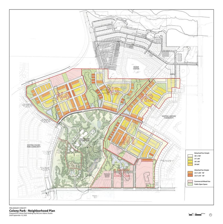
TABLE OF CONTENTS

Executive Summary                                      3
       Project History and Context
       Phase 1 ENA Tasks
       Preliminary Recommendations
       Financial Overview

Land Planning Modifications and Recommendations        10
       Loyola Town Center
       Maximizing Housing Choices
       Density
       Grading
       CEF Mitigation

Preliminary Proforma and Economic Feasibility          15
       Primary Funding Sources
       Other Funding Sources
       Community Benefits and Financial Impact

Project Phasing                                        20

Recommendations for Future ENA Phases                  21

Appendix                                               22

                                                            2
EXECUTIVE SUMMARY

Catellus Development Corporation, in partnership with the City of Austin Economic
Development Department, has included a report of observations and recommendations during
the Exclusive Negotiating Agreement (ENA) period. The ENA period allows for due diligence and
negotiations of the Master Development Agreement (MDA). Further due diligence and
refinements will be needed before moving forward with entitlement, zoning and site plan
changes. Note that this final version contains revisions requested by the City of Austin to the original
document that was delivered on October 10, 2020.

Project History

The Colony Park Sustainable Community (Colony Park) is a community-led effort to develop 208
acres of City-owned property in northeast Austin. When complete, the project on Loyola Lane
between Johnny Morris Road and Decker Lane, is expected to feature a mix of housing types,
retail and office space, a possible transit center (i.e. Green Line proposed by Capital Metro), and
Central Health’s health and wellness center in the Loyola Town Center.

The Colony Park Sustainable Community Initiative began in 2012 as a three-year master
planning process supported through a $3 million U.S. Department of Housing and Urban
Development Sustainable Communities Challenge Grant. Through this process, the City
engaged hundreds of community stakeholders through community meetings, workshops and
family-focused events to create a community vision for the project.

The City of Austin Economic Development Department (EDD) began a Request for Qualifications
(RFQ) and Request for Proposal (RFP) process in 2017. Ultimately, Catellus Development
Corporation (Catellus) was selected in 2018 as the master developer for Colony Park. The
Exclusive Negotiating Agreement was signed between EDD and Catellus on May 12, 2020
ending the procurement process and commencing the due diligence for the negotiation of the
Master Development Agreement. Importantly, Catellus could engage with the community and
begin reviewing the existing Colony Park Planned Unit Development (PUD) and 2014 Illustrative
Plan adopted by City Council (2014 Illustrative Plan).

EDD tasked Catellus with goals for the first phase of the ENA period summarized in this report
of recommendations submitted to City Council for guidance on future phases. These tasks were
to:
    •   Improve the efficiency of the Development Plan [PUD and 2014 Illustrative Plan];
    •   Increase the yield of developable land at the Site;
    •   Decrease the cost of public infrastructure; and
    •   Adhere to the original tenants of the Master Plan and 8 Pillars of need desired by the
        Community.

                                                                                                       3
Project Context

Colony Park is located approximately eight miles northeast of Downtown Austin. The Colony
Park Sustainable Communities Initiative 2014 Illustrative Plan focused on the 208-acre City-
owned tract but was planned within a larger context of the surrounding five-census tract area
extending south to Martin Luther King Boulevard, north to US 290, west to US 183 and east to
Walter E. Long Metropolitan Park. Since the completion of the 2014 Illustrative Plan, this
context has undergone significant change:
    •   Planned communities on previously undeveloped land to the north of Colony Park have
        introduced a significant number of new homes. These new communities include
        Wildhorse Ranch, Whisper Valley and Parker Station immediately adjacent to Colony
        Park.
    •   The community has long advocated for a district park resulting in the 93-acre Colony
        Park District Park, immediately south and west of Colony Park, which broke ground in
        2016 in partnership with the Austin Parks Foundation, the City of Austin Parks and
        Recreation Department and the St. David’s Foundation. The park includes 50 acres of
        land previously identified in the Colony Park planning area. The park (opened March
        2020) includes trails, sports fields and a pool complex (scheduled to open in 2021).
    •   RBI Austin, a non-profit devoted to youth baseball and softball, acquired 33-acres of
        land just south of Colony Park with the intent of “creating a sports complex that looks
        to engage and develop inner-city Austin youth athletically, academically and spiritually,
        empowering them to lead the transformation of their communities”.
    •   Neighborhoods to the south, including Agave, have experienced significant growth
        since 2014.
    •   Walter E. Long Park has undergone a major master plan effort in 2018 calling for
        significant improvements while the County and Austin Rodeo have continued
        discussions with the City of Austin regarding the redevelopment of the Expo Center
        immediately east of Colony Park.
    •   Tesla’s plans for a 2,000-acre manufacturing facility and “giga-factory” just beyond the
        five-census tract area to the southeast will result in up to 5,000 new jobs.

While these changes present new opportunities for Colony Park and the Eastern Crescent of
Austin, challenges remain. The closest major grocery story is more than two miles away from
Colony Park and there are no significant health care facilities east of US 183. In reviewing the
Colony Park 2014 Illustrative Plan, Catellus and the City have taken these challenges and the
changing context into consideration, focusing on addressing the community’s Eight Pillars of
Need. The Draft MDA Illustrative Plan builds on the fundamental goals of the 2014 Illustrative
Plan, while striving to improve its economic viability.

                                                                                                   4
Preliminary Proposed Modifications

The preliminary proposed modifications to the 2014
Illustrative Plan and PUD identify opportunities for efficiencies
in the plan to generate more revenue and reduce the total
cost of the project. These efficiencies plan for the highest and
best use of land area – which creates more marketable sites
for homebuilders, developers, employers and retailers – and
accommodates other community benefits such as the Central
Health Wellness Center and a potential full-service grocery
store. Additionally, the comprehensive review of the PUD and
2104 Illustrative Plan resulted in identified public financing
needs. Many of these proposed revisions are placed in the
context of the identified 8 Pillars of Community Need for
Colony Park.

1. Improve mobility, connectivity, and safety of community
The Right of Way dedicated to roadways and the number of
street sections were reduced in the Draft MDA Illustrative
Plan; however, the same level of mobility, connectivity, and
safety are maintained. Additionally, the 2014 Illustrative Plan
and PUD were revisited to:
   •   Ensure connectivity to adjacent neighborhoods (Colony
       Park, Lakeside and Parker Station);
   •   Ensure connectivity to the proposed Cap Metro Green
       Line Commuter Rail Line, and to provide connectivity
       on Colony Loop Drive for future Purple Line Bus Rapid
       Transit Line;
   •   Ensure sufficient street width is available for fire lane
       safety;
   •   Maintain protected bike lanes on the planned major
       connector roads; and to
   •   Create trails and bike paths that are woven throughout
       the community and connect with pedestrian pathways
       and several entrance points to the Colony Park District
       Park and the future Central Health site.

                                                                    5
2. Improve access to health care resources and services
The community, EDD, Catellus and Central Health have
worked in partnership to identify a site for Central Health’s
proposed Community Health and Wellness Center at Colony
Park. This site will allow the facility to be built before and/or
independently of the implementation of the Colony Park Draft
MDA Illustrative Plan.

The Central Health Site Plan also allows for complementary
commercial uses such as a pharmacy, a public library and
public health offices. The Loyola Town Center may
accommodate future expansion for Central Health on nearby
parcels, if desired and agreed by various parties. Parking
requirements will need refinement to reach market standards
in the PUD zoning to ensure flexibility for Central Health and
other potential commercial uses.

3. Improve access to open spaces and activate parks
Catellus and the City worked with the land planner, civil
engineer and biologist to review the boundaries of the critical
environmental features onsite with the goal of increasing the
quality and purpose of the planned open space. While overall
open space and right-of-way acreage were reduced, improved
park land increased to provide higher levels of amenities to
future residents, employees and neighbors. Additionally, a
central lake park is under consideration (subject to regulatory
approval) as a main gathering space that will connect to
Colony Park District Park.

Catellus and EDD are exploring utilizing undeveloped portions
of the Colony Park District Park to achieve a greater
sustainability effort and strengthen connections between
wetlands and critical environmental features on and off-site.
Trails, bike paths and protected bike lanes are planned to be
woven throughout the community and connect with Colony
Park District Park and surrounding neighborhoods. The
proposed trail system will encompass approximately 2.6 miles.

                                                                    6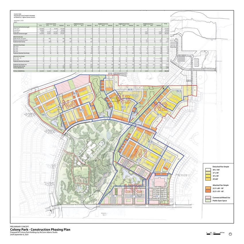
4. Improve access to healthy food resources
The Loyola Town Center site plan was revised to allow greater
flexibility and opportunity to attract a full-service grocery
store and/or other ancillary neighborhood retail options (i.e.
restaurants, financial institution, pharmacy, dry cleaners, etc.).
Additionally, interim uses, including but not limited to, mobile
services, food vendors and CSA delivery are under
consideration.

5. Improve access to economic vitality of community
The Loyola Town Center site plan is under revision to provide
greater flexibility and opportunity to attract employers and
institutions that can provide goods and services, local jobs,
and/or training opportunities. The revised concept would
require modifications to the PUD’s treatment of certain critical
environmental feature setbacks. We will continue to study this
with environmental consultants and work with City staff to
identify the best solutions. Alternatives to the 2014 Illustrative
Plan and PUD near the proposed Cap Metro Green Line also
include commercial and retail opportunities.

6. Improve educational opportunities
The site identified for Central Health’s Health and Wellness
Center is large enough to accommodate other community-
serving uses. Additionally, Catellus will seek opportunities in
existing facilities and future facilities to support education as
planning continues. The City, Catellus and consultants
continue to support community-driven efforts such as the
Back to School Bash and school supply drives for schools in the
LBJ vertical team.

                                                                     7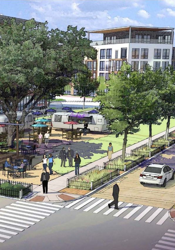
7. Improve equal access to workforce housing
Preliminary land planning concepts illustrate a wide variety of
housing types to address the need for workforce housing.
Housing types will include multi-story, mixed-use multi-family
development options, as well as attached
(rowhomes/townhomes) and detached single-family
residential.

Specifics of workforce housing will be identified in Master
Development Agreement, but there is a continued
commitment to provide 20% of all housing as income
qualified. Future planning will include best practices and
lessons learned to increase access to workforce housing
particularly to historically disadvantaged and displaced
residents.

8. Improve quality of life through accessing available
   City/County resources
Onsite and offsite improvements to infrastructure are under
review including Capital Improvement Projects. Major
thoroughfares (Wilmington and Colony Loop Drive) will be
designed to accommodate Cap Metro buses for expansion of
their high-capacity bus route. Catellus and the City will
continue engagement efforts with the community and
potential partner organizations such as Austin Public Library,
Austin Public Health and Neighborhood Housing and
Community Development. Additionally, Catellus will research
city, county and nonprofit support for existing residents in the
area.

                                                                   8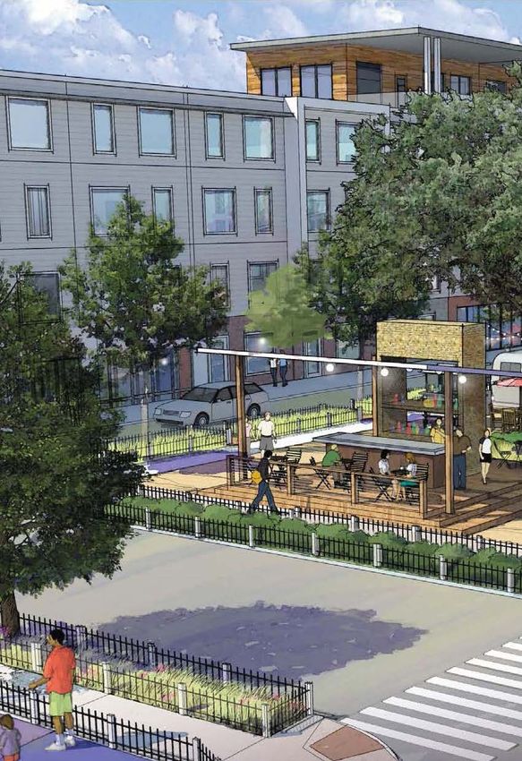
Financial Overview

On September 22, 2015 Economic & Planning Systems (“EPS”) provided a memo to Austin
NHCD identifying an approximately over $100 million financial gap for delivering the
infrastructure needed for Colony Park project. Catellus’ proposal submitted to EDD May 8, 2018
approximated this gap at $127.4 million.

After this initial review of the 2014 Illustrative Plan and PUD, Catellus’ proposed plan changes
have reduced infrastructure costs and increased land revenue. This narrowed the financial gap
to approximately $103.2 million. Closing this financial gap will require various funding
mechanisms such as a Public Investment District (PID), Tax Increment Reinvestment Zone
(TIRZ), and Capital Improvement Projects which are further explored in the Preliminary
Proforma and Economic Feasibility section.

                                                                                                   9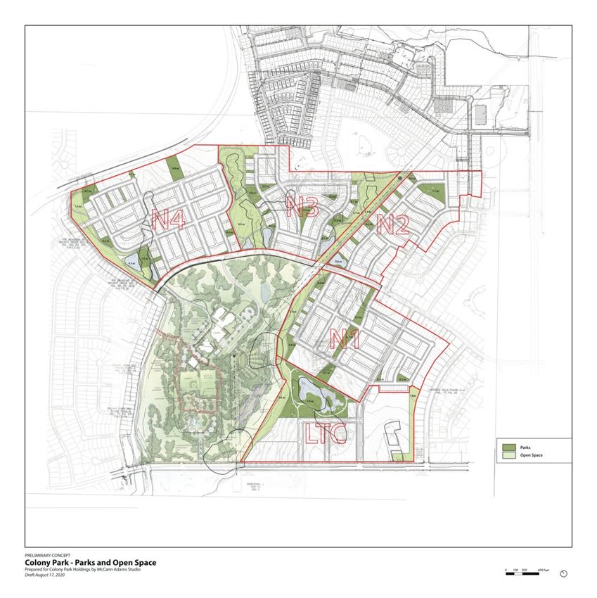
LAND PLANNING MODIFICATIONS AND RECOMMENDATIONS

Catellus engaged McCann Adams Studios for master planning, Civilitude for civil engineering
and Ecosystem Design Group for environmental analysis. These consultants worked in
conjunction with the City of Austin consultant team including Dunaway and Associates and
Economic Planning Systems. The review process focused on site, environmental, financial and
market constraints while working to deliver a revised Illustrative Plan focused on the 8 Pillars of
Community Need. Exhibits are attached in the Appendix to this report to provide additional
information for the land planning efforts include:
   •   Illustrative Plan
   •   Neighborhood Plan
   •   Parks and Open Space Plan
   •   Trails & Bikeways
   •   Cut and Fill Exhibit
   •   Construction Phasing Plan
   •   Ecologist Memo

Loyola Town Center

Located along the Loyola Lane frontage, the Loyola Town Center has the greatest opportunity
for commercial and institutional services. Because of its location and impact to the Colony Park
project, the Loyola Town Center was an early focus for the plan review.

The 2014 Master Plan envisioned the Town Center as a focal point of community gathering and
Innovation Center providing economic growth and jobs in a part of the City that had not shared
in Austin’s dramatic economic expansion. Two significant changes are proposed for the Town
Center:

                                                                                                 10
• Discussions between the City of Austin and Central Health have been successful in
identifying a site within the Loyola Town Center for a Wellness Center, which will
include a CommUnityCare health clinic and other services that will cater to the health
needs of the community. The ~2.2-acre site could support up to 55,000 square feet of
floor area that in addition to the Wellness Center could accommodate offices for Austin
Public Health, a branch Library and a childcare facility.
• The Illustrative Plan for the Town Center has been reconfigured to allow for a 10-acre
parcel along Loyola Lane that could be suitable for a full-service grocery store. This
parcel could also include street-oriented commercial uses (restaurants, retail shops and
offices) that would help to enhance the Town Center as an attractive and lively
destination for the surrounding communities. While the Plan provides for a grocery
store parcel, it is acknowledged that one will still need to be attracted to the site; failing
that, this parcel could still include a mix of other commercial, multifamily and
community-serving uses.
The parcels were resized and reconfigured into a gridded pattern of streets and blocks to allow
maximum flexibility for potential users. These reconfigurations will promote a mix of uses
including multi-family residential that would make the Town Center a more viable day and
nighttime destination. These changes have resulted in a rethinking of the design and treatment
of the adjoining open space and the associated critical environmental features (CEFs). Though
more discussions with environmental consultants and the City’s Watershed Department are
necessary, this open space is envisioned as both a place for community recreation and as a
protected area of ecological value.
Maximizing Housing Choices
Consistent with the 2014 Master Plan, the proposed plan will have the same four
neighborhoods, each framed by the “green fingers” of open space and trails that provide
connections to the Loyola Town Center, Colony Park District Park and Overton Elementary
School. Within these neighborhoods, the Illustrative Plan calls for a wide range of housing
choices to serve different family sizes, walks-of-life and socio-economic groups. These housing
choices will include:
• Single-family detached homes on lots that range in size from 1,600 to 4,000 square feet,
with one, two- and three-story homes that could include two to four bedrooms;
• Accessory dwelling units on the larger detached single-family home lots that could
include studio and one-bedroom units;
• Attached “row houses” oriented to streets or to housing courts on lots that range from
1,100 to 2,000 square feet, supporting two- to three-story homes of two to three
bedrooms;
11• Apartments or condominiums in multifamily complexes fronting onto the open space of
the Loyola Town Center and adjacent to the planned Green Line rail station in the
northwest quadrant of the community.
All of the housing will be designed with a positive orientation to streets and open spaces to
promote a safe and engaging neighborhood environment. Garages will be located along service
alleys or embedded within multifamily buildings allowing streets and sidewalks to be lined with
porches and stoops that promote pedestrian-friendly interaction among neighbors. The Plan
anticipates approximately 1,000 “fee-simple” lots of home ownership and another 1,000
apartment or condominium units.
Density
Through its Project Connect program, the City of Austin and Capital Metro have planned for a
significant public transit investment in Northeast Austin and Colony Park. The plan calls for the
expansion of commuter rail service along the Green Line that will terminate in a first phase at
Colony Park, with future extensions to Manor and Elgin. In addition, MetroRapid bus service
(with 10-minute frequencies) are planned along both Loyola Lane and Colony Loop Drive.
Together these investments will ensure that all existing and future residents of Colony Park will
be within a convenient ten-minute walk of high capacity transit.
In order to reinforce this public investment, the Illustrative Plan concentrates the highest-
density housing adjacent to or in close proximity to these transit facilities. For example, row
houses will front Colony Loop Drive and multifamily apartments are proposed within the Loyola
Town Center and adjacent to the planned Green Line rail station.
Grading
The proposed streets generally follow the existing
topography preserving the hilltop characteristics for each
of the neighborhoods. Most proposed street slopes reach
a 4% maximum to maintain walkability throughout the
community while minimizing grade drop across the lots to
attract wide range of homebuilders. The eastern edge of
Neighborhood 2 does reach a slope close to 10% is in
order to tie back to the existing streets (Valleyfield Dr.).
Proposed grading by the Parker Station project to the
north was studied to verify feasibility of the street
connections shown in Illustrative Plan.
12Four out of five proposed street connections between Colony Park Sustainable Community and
Parker Station are feasible. The fifth connection (Wheatgrass Path) in Neighborhood 2 has a
grade difference of over 15 feet between the two sites. To close this gap, significant fill would
need to be added and the slope of several north-south streets be increased to 10-13%. This
street connection only affects two lots on the Parker Station side. As a result, this connection is
not recommended due to added fill cost, reduction in pedestrian connectivity and reduction in
marketability of the lots due to high street cross slope.
Preliminary cut and fill studies were performed to validate street connections, assess the true
limit of disturbance into green space and quantify the cost impact of the proposed grading
strategies. Neighborhood 2 and 4 are closely balanced within their boundaries. The Town
Center and Neighborhood 1 are cut positive by design so they can utilize the excess soil from
the Mueller project. The quality fill soil was transported from Mueller and is currently
stockpiled at the Colony Park site. This saves cost and provides Colony Park access to quality fill
soil. Neighborhood 3 is fill positive partly to catch up to the grading at Parker Station as
discussed above. This is where it became clear that eliminating the east-west vehicular streets
between Neighborhoods 2, 3 and 4 creates several benefits to the project.
Eliminating these connections reduces encroachment into the critical environmental area as
well as allows the grading of each neighborhood to be more efficient. A street connection
between Neighborhoods 3 and 4 would require a bridge that spans at least 100 feet in length
and drops almost 30 feet from one end to the other. The alternative would be to raise the
grading of Neighborhood 4 which, in turn, affects its connection back to the existing
neighborhood to the west and the walkability within. Our recommendation is to provide east-
west pedestrian and bike connections between the neighborhoods rather than vehicular.
Along the edges of each neighborhood, especially the ones next to the “green spines”, concrete
masonry unit (CMU) block walls with geogrid fabrics are anticipated to be used to retain the
soil. This design is intended to enhance stability along the creek banks while minimizing the
amount of grading that happens closer to the creek centerline. This design will add more critical
green space to the CEF buffer and allow more of the natural soil and vegetation along the creek
to be restored as recommended by ecological studies.
13CEF Mitigation
In order to enhance the land use plan and
fulfilling the eight community pillars, we believe
careful study and adjustments to the original
critical environmental feature (CEF) setbacks in
the existing 2014 PUD are essential in setting up
the project for success. Note that while our
proposed high-level strategies deviate from the
2014 PUD, we believe they remain superior to
the standard setbacks in the base line codes.
Our goal is to continue to develop finer details
with our ecologist and land planner to balance
environmental benefits with the social needs in
subsequent phases as the project moves
forward.
The proposed land use plan will impact one wet land feature at Neighborhood 3 and headwater
CEF setbacks at three other areas – Town Center near future Central Health site and potential
grocery site, and neighborhood 4 near the railroad. Our key strategies to mitigate this impact
are: creating and widening continuous north-south green spines between Colony Park and
adjacent sites; enhancing drainage and incorporating shallow, diverse, wetland features within
these green spines; restoring and enhancing existing wetland features as well as creating
potential opportunities for new wetlands; finally, incorporating design elements such as
rainwater capture elements and other low impact development techniques into commercial
sites and parks upstream.
Specifically, to the restoring and enhancing wetland features strategy, in conjunction with our
ecologist, the design team has conducted several site visits to update the 2014 environmental
resource inventory and develop multiple design approaches. The intent is to achieve
reestablishment of ecological function and related physical, chemical, and biological linkages
between terrestrial and aquatic ecosystems. This approach is not limited to replacing a few
species here and there, but rather, protecting and rebuilding complex landscapes. Further
details can be found in the ecologist’s report attached in the Appendix and studies will be
further developed as the project moves forward.
14PRELIMINARY PROFORMA AND ECONOMIC FEASIBILITY
In a 2015 memo from Economic & Planning Systems to Neighborhood Housing and Community
Development (NHCD), a $100 million funding gap was identified based on the 2014 approved
Colony Park Sustainable Community Initiative Master Plan. It was contemplated that a Tax
Increment Financing (TIF) district, Public Improvement District (PID) and other form of subsidies
would be needed to make the project financially feasible.
In Catellus’ 2018 RFP response, Catellus identified an approximately $127 million funding gap
that was contemplated to be bridged by a TIF, PID and other funding sources. Since the date
the Exclusive Negotiation Agreement (ENA) was executed, Catellus and the City’s key focus has
been to identify areas for modification from a planning perspective so a more efficient land use
plan can help to increase density and reduce costs while adhering to the original tenets of the
Master Plan and the identified 8 Pillars of Community Need for Colony Park.
With a more efficient design for street connections and open space including revisiting the
Critical Environmental Features (CEFs), the current proposed land use plan resulted in a 15.9-
acre increase of developable land for residential and commercial uses. As a result, compared
with the 2018 Catellus RFP response, which was based on Catellus’ lotting plan derived from
the 2014 approved Master Plan, residential homes increased from 1,672 homes to 1,903
homes, a net increase of 231 units.
For the commercial spaces including office, retail and institutional, the planned uses increased
from 127,500 square feet to 359,650 square feet, a net increase of 232,150 square feet.
Sep 20' vs.
PROGRAM COMPARISON 2018 RFP* Sep-20 2018 RFP
Single Family Detached 644 654 10
Single Family Attached 202 418 216
Total Single Family (units) 846 1,072 226
Multifamily 826 831 5
Total Residential (units) 1,672 1,903 231
Retail 45,000 130,000 85,000
Office / Institution 82,500 229,650 147,150
Total Commercial (sq.ft.) 127,500 359,650 232,150
*Based on Catellus lotting plan derived from 2014 Master plan
Our current financial analysis is based on the updated land use plan and comparable market
transactions. The infrastructure costs were developed based on a May 2018 estimate with
15certain unit pricing increased by 2.7%. Also, a 3% annual inflation is applied to both sources and
uses. Below is the summary of the sources and uses comparison between 2018 RFP submission
and current analysis:
Sep. 2020 vs.
2018 RFP Sep. 2020 2018 RFP
SOURCES
Residential 78,443,509 101,337,345 22,893,836
Commercial (Office, Retail & Insitutional) 3,602,590 4,059,494 456,904
Total Land Sales Revenue 82,046,099 105,396,839 23,350,740
USES
Infrastructure Hard & Soft Costs 169,567,723 163,167,728 (6,399,994)
Development Costs 23,762,387 24,901,513 1,139,126
Other Costs 16,133,266 20,576,287 4,443,020
TOTAL COSTS 209,463,377 208,645,528 (817,849)
FUNDING GAP 127,417,277 103,248,688 (24,168,589)
Per the table above, the land sales revenue increased by approximately $23.4 million due to
higher density and improved land value assumption per recent market comps. Total uses of
funds (i.e., costs) held relatively steady and the total funding gap decreased by approximately
$24.2 million from $127.4 million to $103.2 million, a 19.0% reduction.
Catellus engaged with home builders, commercial developers and real estate brokers to
understand the current market values for various product types contemplated for Colony Park.
This information is incorporated in the underlying land values. In addition, Catellus engaged
with contractors, landscape architects, engineers and other professionals to determine the cost
of implementing the Illustrative Plan attached to this report. The land values and costs are
reflected in the proforma.
Primary Funding Sources for the Funding Gap
Due to the size of the funding gap, the City of Austin, with support from Catellus, will need to
explore various funding mechanisms for the feasibility of this project. There are three
significant funding sources identified to address the funding gap:
16Sep. 2020 vs.
2018 RFP Sep. 2020 2018 RFP
Potential PID (paid by Property Owner) 25,679,903 15,420,718 (10,259,185)
Public financing & Other Funding Sources
Potential TIRZ from COA Participation 30,111,660 39,659,186 9,547,526
Other Funding Sources 71,625,714 48,168,785 (23,456,929)
Total Public Financing & Other Funding Sources 101,737,374 87,827,971 (13,909,403)
TOTAL POTENTIAL FUNDING SOURCES 127,417,277 103,248,689 (24,168,589)
1. Public Improvement District (PIDs) which allows the city to issue bonds based on additional
assessments to be collected from property owners of the project to lower the cost of capital
and to offset infrastructure costs. PIDs provide critical funding necessary during the early
stages of the development. In the proforma, Catellus updated the PID assumptions to
conform with the latest city issued PID policy which resulted in an approximately $10.3
million reduction in PIDs proceeds from $25.7 to $15.4 million. The PID does allow for
upfront financing at a lower cost of capital which reduces Catellus’ peak equity. Exploring
potential variances to the City PID policy could expand available funds for the Project (e.g.,
extending the term of the PID to 25 or 30 years).
2. Tax Increment Reinvestment Zone (TIRZ) which allows the city to issue bonds based on
incremental property tax value generated from the project to fund infrastructure costs.
Since this is normally based on the value in place at the time of the TIRZ debt issuance, the
TIRZ financing provides reimbursement financing for project costs, but does not address the
“gap” in the up-front funding that is necessary during the early construction phases of the
development. Assuming the full bonding capacity of the project, with 3% annual inflation,
the bonds could generate approximately $39.7 million in TIRZ funding based on the sole
participation of City of Austin, which is $9.5 million higher than what was in the 2018
proposal from Catellus. The TIRZ is beneficial to the project as a reimbursement tool,
however it requires capital from Catellus to fund the project initially, which comes at a
higher cost of capital.
3. Other Funding Sources. The combination of the PID and TIRZ does provide a significant
portion of the necessary funding but does not fully fund the currently projected financing
gap. Additional funding mechanisms to consider could include: (A) expanding the
geographic area of the TIRZ; (B) requesting participation from Travis County in the TIRZ; (C)
participation from the City for select Capital Improvement Projects (CIP); and (D) potential
fee waivers.
17Potential TIRZ from Travis County Participation $33,053,170
Potential CIP 43,350,463
Colony Loop Drive 5,303,940
Wilmington Street 4,353,931
Offsite Regional Detention and Water Quality Pond 1,901,273
Offsite Wastewater Improvements 4,664,276
Parks & Open Space 27,127,044
Potential Reimbursement & Fee Waiver 10,376,810
Austin Energy Work Request Charges 5,420,484
Traffic Impact Fee 553,245
City of Austin Site and Subdivision Inspection Fees 2,732,801
Texas Gas Reimbursements 1,670,280
Total Potential Other Funding Sources $86,780,444
A. Expanded TIRZ could include potential expansion of the TIRZ boundary beyond the
208 acres to including the larger surrounding area. Also, as shown in the table above
it could include potential participation of the County in the TIRZ.
B. The City’s request to Travis County for TIRZ participation could generate additional
$33.1 million beyond the amount that the City’s tax revenues could support utilizing
full bonding capacity of the project.
C. Capital Improvement Project (CIP) funding could include funding for up to $43.4
million of identified eligible projects such as:
o Colony Loop Drive: Design and construct a 650 LF public road segment of Colony
Loop Drive between Loyola Lane and Decker Lane.
o Wilmington Drive: Design and construct an 1888 LF public road segment
between Colony Loop Drive and Loyola Lane.
o Offsite Regional Detention and Water Quality Pond Improvements: Design and
construct the modifications to two existing detention and water quality ponds
located offsite on the AISD / Overton MS Colony District Park to facilitate
upstream development, including Colony Park.
o Offsite Wastewater Improvements: Design and construct the replacement of
6620 LF of an existing offsite public wastewater line to facilitate upstream
developments, including Colony Park.
o Parks and Open Space: Provide funding to facilitate the design and construction
of 19.8 acres of public Parks and 32.1 acres of public Open Space.
D. Other potential fee waivers or reimbursement could provide up to $10.4 million
including:
18o Austin Energy Work Request Charges: Waive charges associated with Austin
Energy’s primary distribution cable and equipment Work Requests.
o Traffic Impact Fees: Waive Traffic Impact Fees associated with the Colony Park
PUD.
o City of Austin Site and Subdivision Inspection Fees: Waive Site and Subdivision
Inspection Fees.
o Texas Gas Reimbursements: Texas Gas typically reimburses developers who
install their facilities.
19PROJECT PHASING
Development of residential subdivisions is currently taking approximately 20-24 months in the
City of Austin: 8-10 months for design/permitting and 12-14 months for construction. Catellus
will expect to begin development work on Colony Park upon the execution of the MDA, which
would mean the first phase of Colony Park could be in place 20-24 months after execution of
the MDA and proper entitlements/amendments being put in place.
Based on the current proposed land use plan, the first phase of development will include
construction of 316 single family residential lots in Neighborhood 1, which will be connected to
Loyola Lane with a new entrance roadway. Neighborhood 1 will be constructed in three phases.
Phase 1A will include 123 single family lots, Phase 1B will include 94 single family lots and Phase
1C will include 99 single family lots. The construction of the next phase will generally follow the
completion of the prior phase.
Development of Neighborhoods 2, 3 and 4 will follow in generally the same pattern as
Neighborhood 1, with the construction of each phase beginning upon the completion of the
prior phase. Development of the three phases of Loyola Town Center will be responsive to
market conditions.
Construction of neighborhood parks and open space will begin at the appropriate time for each
phase.
20RECOMMENDATIONS FOR FUTURE ENA PHASES
Significant changes to the PUD are needed to implement the proposed Draft MDA Illustrative
Plan. After meeting with various City departments, Catellus recommends filing for a new PUD. A
new PUD will take equal, if not less, time than amending the current PUD. The new PUD will
adhere to the 8 Pillars of Need, honor the original vision and create flexibility to accommodate
commercial users, new home styles and connections to development that has occurred since
the original 2014 Illustrative Plan and PUD.
At the conclusion of Phase 1, Catellus is recommending a Phase 1 Extension which will include
future outreach efforts and meetings with City departments to identify where improvements
can be made to deliver community benefits not only for the 208 acres, but also the surrounding
neighborhoods, while the City of Austin secures the financial commitments to close the funding
gap. Catellus will support the City of Austin during the ENA Phase 1 Extension, which is
estimated to take up to six (6) months, or the necessary time to procure public financing and
CIP commitments to bridge the $103.2 million funding gap.
Additionally, Catellus will continue community engagement to refine the Draft MDA Illustrative
Plan and receive input on future MDA items. To maintain safe social distancing, engagement
events will be planned virtually until it is safe to host events or meetings. Topics for these
virtual meetings could include items for the MDA and general topics such as workforce housing,
parks programming, streets/trails/bike lanes, zoning, the Loyola Town Center, retail and
services, healthcare, and community partnerships.
Future ENA phases are estimated to commence after the recommended Phase 1 Extension.
Such tasks include, but are not limited to, finalizing the Draft MDA Illustrative Plan and
preparing to file for new PUD zoning. In preparation of this next step, Catellus will continue
meeting with various City departments in efforts to obtain approvals for the changes
contemplated in the Draft MDA Illustrative Plan.
Appendix
21[Attached]
22MEMO
DATE September 3, 2020
PROJECT NAME Colony Park
MAIN CONTACT Catellus, Civilitude
SUBJECT CEF mitigation
OVERVIEW
The Ecosystem Design group performed a rapid ecological assessment of Colony Park in Austin Texas in
July of 2020 to document existing conditions1. The goal of the assessment was to develop an
understanding of the site that could be used to help the design team develop rough strategies for
protecting and enhancing ecological function within the constraints of the development’s current
design. This memo outlines those potential strategies.
Edits to the original master plan intended to accommodate the social and financial needs of the project
resulted in loss of previously defined CEFs, which include headwaters and a wetland. We suggest several
strategies to mitigate this loss. The primary strategies are greater protection and functional
enhancement of the central drainage and incorporation of shallow, diverse, wetland features within this
green spine. Wetland enhancement will combine protection and restoration of existing features as well
as creation of new features to offset losses. Function here includes hydrologic function, nutrient cycling,
energy capture and wildlife habitat. The goal of restoration is to restore ecosystem processes, not
simply to replace components. Secondary strategies include incorporating water capture elements such
as cisterns and raingardens into commercial properties feeding drainage areas.
1
Complete findings documented in the 2020 Colony Park Ecological Site Assessment Report
1CURRENT CONDITIONS
Soils
• Soils are highly erodible and significant erosion was noted in drainages and in some upland
areas, even with high vegetative cover in the immediate area. It is evident that some overland
flow and in-channel flow are high energy. These factors combine to demonstrate the necessity
for healthy setbacks, both around the existing drainages and CEFs.
Drainages/wetlands
• Drainages and wetlands retain diverse communities and much of the site is stabilized by these
communities, though some areas are experiencing significant erosion.
• Stream restoration can include stabilization of the banks and streambed, addition of large
woody debris, rock and vegetation to increase complexity and cover. However, focusing solely
on bank stability can result in poor ecological condition. Connection to the floodplain and
uplands should be considered.
• Small mesic benches are scattered along the central drainage and should be protected and
enhanced.
Uplands
• Upland areas are diverse, with many remnant prairie grasses including Indiangrass (Sorghastrum
nutans) and little bluestem (Schizachyrium scoparium) which were common throughout the site.
These species’ density on the Colony Park site is a rarity. They have been greatly reduced due to
overgrazing, brush invasion and invasive species expansion. There is great potential to harvest
these grasses to provide local genotypes in restoration efforts on and off site.
STRATEGIES
Greater protection and enhancement of central drainage
• Protect 100’ buffer prescribed by COA from all construction impacts. Expand buffer beyond 100’
where possible to provide connection to floodplain and uplands.
o Protect 100’ buffer from all construction impacts – Exclude heavy machinery except for
defined crossing areas. Plan to actively restore crossing areas following construction.
Active restoration includes soil repair, revegetation with diverse, appropriate,
communities and temporary irrigation to facilitate establishment.
o Soil and material laydown areas should be located a reasonable distance from
preservation/protection areas
• Restore buffer and channel to reduce flow velocity, improve water quality and provide habitat
o In areas not directly impacted by construction, this will entail increasing species diversity
with additional facultative wetland species in the riparian area and appropriate species
in uplands.
o Areas impacted by construction will need soil restoration/stabilization along with
revegetation efforts coupled with temporary irrigation, combined live planting and
seeding, and invasive management during establishment
o Limit soil import into buffer areas
• Restoration efforts should be based on the reestablishment of ecological function and related
physical, chemical, and biological linkages between terrestrial and aquatic ecosystems. Thisapproach is not limited to replacing a few species here and there, but rather, protecting and
rebuilding complex landscapes.
• Consider raising streambed elevations and increasing channel roughness. Water can be slowed
in channel by creating pool and riffle sequences with rock or large woody debris. The team will
need to develop a sound strategy ensuring adequate water movement while slowing non-
significant events. The strategy may need to accommodate moderate amounts of meander.
• Buffering of drainage will need to be combined with upland catchment strategies as well as
downstream retention to maintain hydrograph as well as reasonable ecological function within
protected drainages and wetlands.
o Consider tying in with COA efforts to increase upland catchment with cisterns/slow
release on properties feeding to CEFs
o Consider protecting and incorporating strategic upland areas for water quality and
habitat reasons. Healthy uplands will slow water movement and delay peak flow within
the drainages.
o Reduce construction impacts within drainage and wetland buffer areas.
o Restore CEF areas so that they represent historic climax conditions or plant communities
that optimize hydrologic function
Mitigation for loss of shallow wetland and catchment area
• Incorporate equivalent area of shallow wetland into the edge of wet-pond. Incorporate a series
of small wetland features along drainage., either through protection or creation
• Vegetate with diverse, appropriate, communities
Mitigation for eastern headwater, slated for grocery store.
• Onsite water capture and slow release – size cistern for significant capture
• Parking lot capture and filtration
• Consider a green roof to replace some pollinator habitat and provide some storm pulse
buffering. Consider salvage of upland plants from adjacent savanna for use in green roof/parking
lot LID features, and green buffer to east.
Mitigation for western headwater
• Upland capture on commercial property
• Protection of remaining headwater
• Enhanced buffer and protection of central drainage.
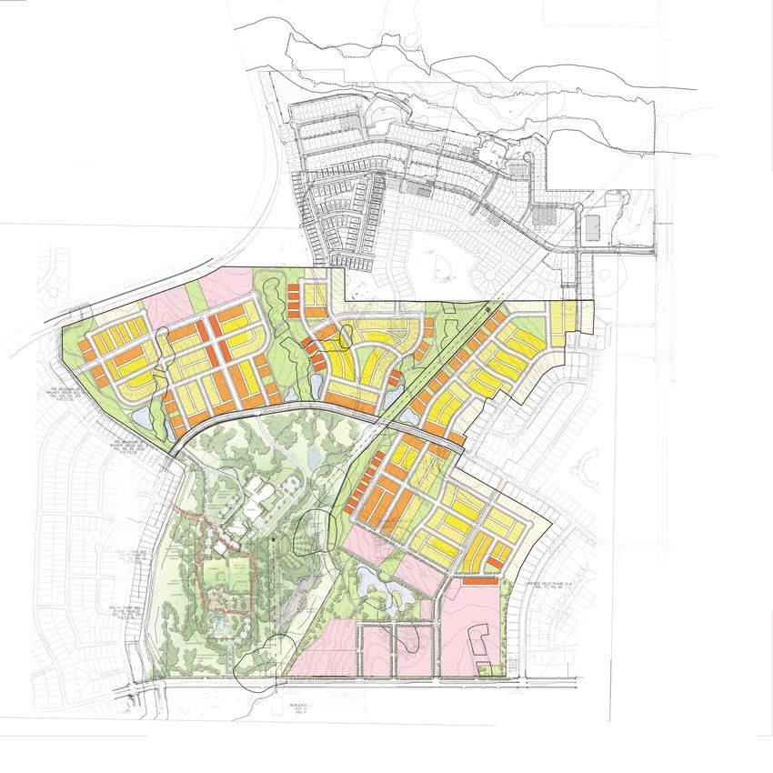
• Appropriate downstream catchmentPARKER
STATION
EXISTING LAKESIDE
COMMUNITY
COLONY PARK
DISTRICT PARK
EXISTING COLONY
PARK COMMUNITY
Detached Fee-Simple
38’ x 100’
37’ x 90’
30’ x 90’
26’x60’
Attached Fee-Simple
22.5’ x 80’ - 90’
22.5’ x 50‘ - 60’
Commercial Mixed Use
Public Open Space
PRELIMINARY CONCEPT
Colony Park - Illustrative Plan
Prepared for Colony Park Holdings by McCann Adams Studio 0 100 200 400 Feet
Draft September 16, 2020PARKER
STATION
N4 N3
N2
EXISTING LAKESIDE
COMMUNITY
EXISTING COLONY
PARK COMMUNITY
COLONY PARK
DISTRICT PARK
N1
Detached Fee-Simple
38’ x 100’
37’ x 90’
30’ x 90’
26’x60’
LTC
Attached Fee-Simple
22.5’ x 80’ - 90’
PROPOSED
CENTRAL 22.5’ x 50‘ - 60’
HEALTH
Commercial Mixed Use
Public Open Space
PRELIMINARY CONCEPT
Colony Park - Neighborhood Plan
Prepared for Colony Park Holdings by McCann Adams Studio 0 100 200 400 Feet
Draft September 16, 2020PARKER
STATION
0.9 ac
0.1 ac
0.2 ac
0.2 ac
0.7 ac 1.1 ac
0.6 ac
N3
0.2 ac
0.1 ac
1.3 ac
N4
0.5 ac
5.1 ac 4.0 ac
0.2 ac
0.18 ac
9.9 ac
0.1 ac
0.1 ac
0.4 ac
0.22 ac
N2
1.5 ac
4.3 ac
0.8 ac
EXISTING LAKESIDE
COMMUNITY
0.3 ac
3.3 ac
0.7 ac
EXISTING COLONY
PARK COMMUNITY
COLONY PARK
DISTRICT PARK
0.4 ac
N1 0.7 ac
0.7 ac
0.1 ac 0.2 ac
1.8ac
2.8 ac
8.4 ac
Parks = 19.8 acres
LTC
Open Space = 32.1 acres
PRELIMINARY CONCEPT
Colony Park - Parks and Open Space Plan
Prepared for Colony Park Holdings by McCann Adams Studio 0 100 200 400 Feet
Draft September 16, 2020Protected Bikeway
Off-street Trails
Planned
MetroRail PARKER
Station
T STATION
N4 N3
N2
EXISTING LAKESIDE
COMMUNITY
EXISTING COLONY
PARK COMMUNITY
COLONY PARK
DISTRICT PARK
N1
LTC
Loyola Lane Bikeway (By City of Austin)
PRELIMINARY CONCEPT
Colony Park - Trails and Bikeways
Prepared for Colony Park Holdings by McCann Adams Studio 0 100 200 400 Feet
Draft September 16, 2020N
LA LN
LOYO
LOYOLA LNPARKER
STATION
5
8 10
18 12 6
8
11 N3-B 15 8
31 113 LOTS N2-B
N4-B 6
28 94 LOTS
119 LOTS 34
N3
39
31
26 21 3
8 8 30
N4
6
N2
4
30 8
22
8 27 4 N3-A 20
103 LOTS 15
N4-A POND
N3-A
6
106 LOTS 21
20
POND 21
N4-C 30
8 N4-A N2-A
116 LOTS 8 31 POND 105 LOTS
N3-A
POND 30
22
N4-C 15
POND
N2-A
8
POND EXISTING LAKESIDE
N4-A COMMUNITY
28
9
26
N1-B 11
94 LOTS
15
N1
36 20
COLONY PARK
DISTRICT PARK
20 17
EXISTING COLONY 30
PARK COMMUNITY N1-A N1-C
26
123 LOTS 99 LOTS
22 27
16 Detached Fee-Simple
38’ x 100’
37’ x 90’
13
POND 30’ x 90’
LTC-1/N1-A
26’x60’
LTC
Attached Fee-Simple
22.5’ x 80’ - 90’
22.5’ x 50‘ - 60’
LTC - 1 LTC - 2 LTC - 3
Commercial Mixed Use
Public Open Space
PRELIMINARY CONCEPT
Colony Park - Construction Phasing Plan
Prepared for Colony Park Holdings by McCann Adams Studio 0 100 200 400 Feet
Draft September 16, 2020You can also read