JULY 2021 - Derbyshire Dales District Council
←
→
Page content transcription
If your browser does not render page correctly, please read the page content below
JULY 2021

   Page 1
Contents
                                                                                     Page
        1 Introduction & Acknowledgements                                             3
        2 Neighbourhood Area Map                                                      4
        3 Historic Background                                                         5
        4 Groups, Activities & Amenities                                              6
        5 Planning Context                                                            7
        6 Community Engagement                                                        8
        7 Kirk Ireton Community Vision                                                9
        Policies:                                                                    10
              P1 Development                                                         11
              P2 Protecting Views                                                    17
              P3 Conservation Area                                                   18
              P4 Business Development                                                22
              P5 Parking                                                             23
        Acknowledgements                                                             24

                             Supporting Documents
                are available on line at the following addresses:
Kirk Ireton Neighbourhood Plan - Conditions Statement & Appendices
https://www.derbyshiredales.gov.uk/images/documents/K/2021_05_13_KI_NP_Conditions__Appendices.pdf
Kirk Ireton Neighbourhood Plan - Consultation Statement & Appendices
https://www.derbyshiredales.gov.uk/images/documents/K/KI_NP_Consultation_Statement_&_Appendices.pdf
KI NP Designation Map Parish Area
https://www.derbyshiredales.gov.uk/images/KI_NP_Designation_Map_Parish_Area.pdf
Conservation Character Appraisal
www.derbyshiredales.gov.uk/kinpconservationcharacterappraisal
Landscape Sensitivity Study
www.derbyshiredales.gov.uk/kinplandscapesensitivitystudy
Rural Place Profile Oct 2013
https://www.derbyshiredales.gov.uk/images/K/KI_NP_Rural_Place_Profile_Oct_2013.pdf
Survey Results 2016
https://www.derbyshiredales.gov.uk/images/K/KINP_Survey_Results_2016.pdf
History of the Village Field
https://www.derbyshiredales.gov.uk/images/K/KINP_History_of_the_Village_Field.pdf

                                                   Page 2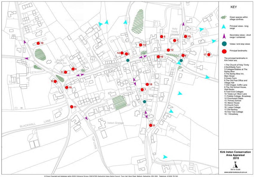
1 Introduction
1.01   A Neighbourhood Plan aims to give local people a recognised input into what happens in their area in a
       specific time period. It derives from the Government’s Localism Act November 2011 and The
       Neighbourhood Planning (General) Regulations 2012.
1.02   The Neighbourhood Plan will provide a framework for guiding future development within the area
       and will form part of the statutory development plan alongside the adopted Derbyshire Dales Local
       Plan, and be used in the decision making process for the determination of planning applications.
1.03   Kirk Ireton Parish Council initiated the formation of the plan in April 2014 when they applied to
       Derbyshire Dales District Council. The whole of Kirk Ireton Parish was designated as a Neighbourhood
       Plan area on 5th September 2014. The Plan once made will be regularly monitored by the steering
       committee.
1.04   Kirk Ireton Neighbourhood Planning Group came into being after the first public meeting in October 2014
       at which the local community gave overwhelming support for the development of a Neighbourhood Plan
       for the village.
1.05   Over the following months the Steering Committee and working groups gathered information and
       opinions about the future of our village. The three groups produced maps and detail about how the
       village had developed and changed over the years. They looked at the amenities within the village and
       the natural environment particularly that within the Conservation Area. A questionnaire was compiled
       which went to all households in the neighbourhood area. The data collected enabled the group to create
       a Neighbourhood Plan to set out a vision for Kirk Ireton which reflects the feelings of local people about
       the future of their village and its environment.
1.06   The creation of the plan aimed to be as inclusive as possible with several open meetings, an information
       website and a stall at the village Wakes. The village school also played its role with a project based on the
       local area.
1.07   The Parish Council will monitor the implementation of the Neighbourhood Plan to ensure that its
       objectives are being delivered. At least every 5 years the Plan will be reviewed to see whether a new or
       modified Plan is required.

                      Presentation of findings from the working groups in October 2015

                                                    Page 3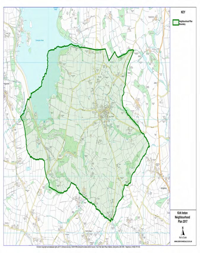
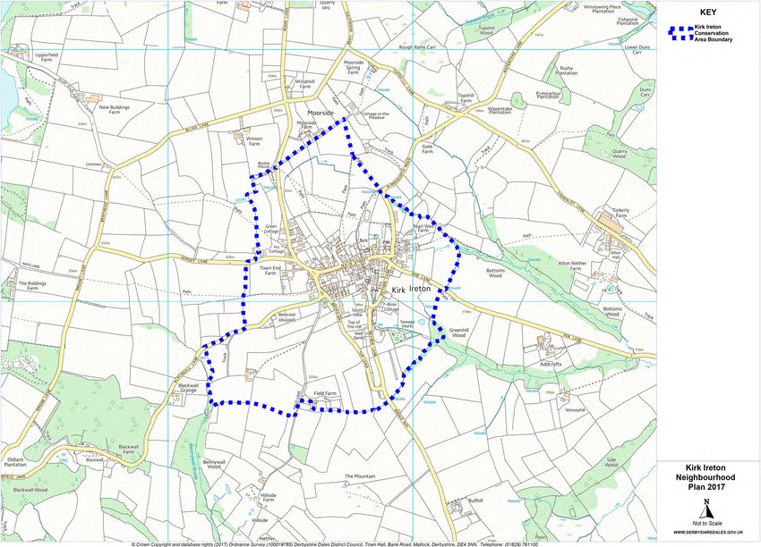
2     Neighbourhood Area Map
The Neighbourhood Area is as defined by the Kirk Ireton Parish boundary. This area was designated by
Derbyshire Dales District Council on 5 th September 2014. Although the Neighbourhood Plan Area includes
the whole Parish of Kirk Ireton, because the majority of the population reside within the village of Kirk Ireton,
the Neighbourhood Plan focuses on the main village settlement. The Neighbourhood Area is detailed on the
following map.

                                                    Page 4
3 Historic Background
3.01   There has been a settlement here since
       the Bronze Age and Kirk Ireton remains a
       thriving community to this day, with a
       population of 518 at the 2011 census.
3.02   In the past the main occupation was in
       agriculture and its associated trades. It
       was a self sufficient community, with a
       general store, bake house, butcher,
       shoemaker, joiner/ undertaker, builder,
       and two fish and chip shops.
3.03   The number of working farms dropped
       from nine to only one remaining today
                                                                         Holy Trinity Church
       over a period of 25 years. The number of
       residential properties rose by 42 - some new build and others converted farm buildings / farm
       houses and shops. Many residents today are professional people who commute to work daily in
       Derby, Nottingham, etc. There are also a number of retired residents.
3.04   Holy Trinity Church dates from 1120 AD and is still active. It is part of the Wirksworth Team
       Ministry, although it does not have its own clergy living in the village. There were two Methodist
       Chapels, the larger of which was sold and converted into a house in the 1980s. The smaller is still
       in use as a chapel.
3.05   There were many pubs, five in the 1850s dwindling down to two in the latter part of the 20 th
       century, and today only the Barley Mow remains.
3.06   Ownership of the Church Institute, built in 1911, was transferred to the Parish Council in 1972
       and is now the Village Hall. The hall was renovated in 2002 with grants from Severn Trent. It is
       well used but there is no car parking and limited catering facilities.
3.07   In the 1800s an Elementary School for boys and girls was established on Well Bank. It moved to
       the present site on Main Street in 1882. In 2016 the number of pupils was 53 which is near the
       full capacity of 56. Currently the number is 51. Numbers have not been less than 50 since
       2006/7. Land to the rear of the school has been “notified” by the Derbyshire Dales District
       Council for future expansion, if required.
3.08   In the 1980s there was a food shop/newsagents (Kirk Ireton Food and Wine Store) and a
       separate Post Office/ sweet shop operating in the village. When the post mistress retired the
       post office moved into the shop. When the shop owners decided to sell the business the post
       office and shop were moved into temporary premises in the garage at Rosebank Cottage. It later
       moved back to the old shop premises when it was bought by a village family.
3.09   In 2001 the Food and Wine Store
       ceased trading and the shop was
       converted into a house, now
       Candlewick Cottage. The owners of
       the Barley Mow offered to convert
       their stable to accommodate both
       Shop and Post Office. When the Post
       Office was closed due to cuts the
       Stable Shop was turned into a
       Community       Shop     manned      by
       volunteers, two part-time paid
       managers, and a management
       committee of local residents.

                                                Page 5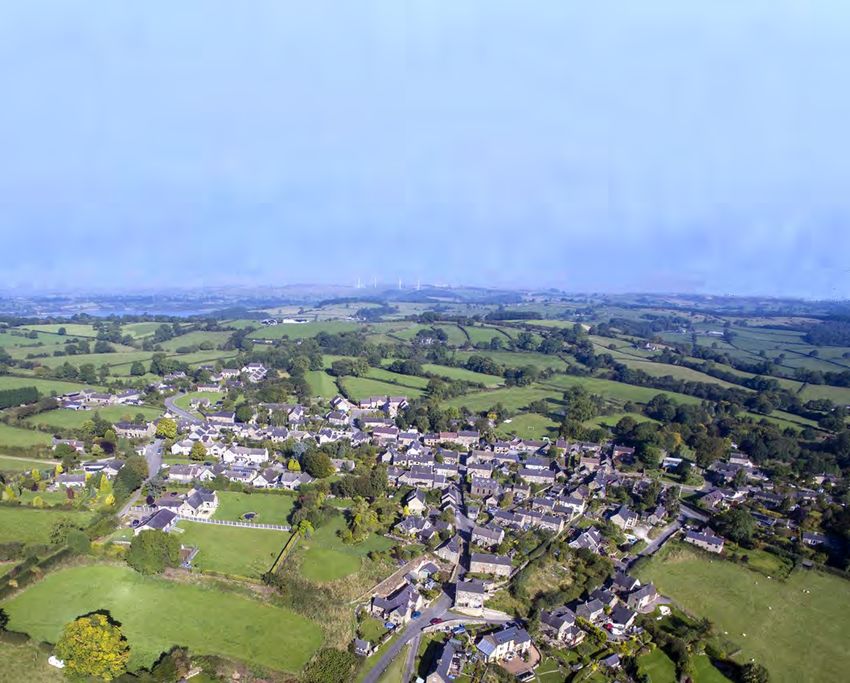
4 Groups, Activities & Amenities
4.01     Kirk Ireton is a vibrant and caring community which organises and supports a number of events.
         Kirk Ireton Community Association (KICA) organises Wakes Week celebrations, various other
         events and Bonfire Night. An Open Gardens Group organise a weekend where residents open
         their gardens to the public; exhibitions and teas are provided at various venues.
4.02     The Village Hall is well used by various groups such as KICA, the Church and other groups for
         entertainment such as quiz evenings. A Luncheon Club meets once a month, the local WI (Ireton
         Wood and Idridgehay) hold their monthly meetings there. There is a singing group, various
         school clubs, a Friendship Group, a Running Group, Pilates and Yoga sessions, an under 5s group
         and a Book Club which meets once a month in the Barley Mow.
4.03     The Village Field is used for recreation and by the Village School. It was bought as a community
         asset for the Villagers of Kirk Ireton and Callow in 1994*.
4.04     A monthly Diary is published to keep villagers informed and report on activities.

                                                  WAKES 2017
       Clubs, groups and organisations who regularly meet at various locations in the Village include:
                 Holy Trinity Church Services                         Luncheon Club - Village Hall
                 Parish Council - Village Hall                      Women's Institute - Village Hall
                 Methodist Chapel Services                        Open Gardens Group - Barley Mow
                Fellowship Group Excursions                           Toddler Group - Village Hall
          KI Community Association - Barley Mow                 Singing Group - Trinity Church / Chapel
                 School Governors - School                              Book Club - Barley Mow
               Friends of the School - School                        Boules players - Village Field
               Shop Committee - Barley Mow                            Meditation, Yoga, Pilates, etc

*History of the Village Field
https://www.derbyshiredales.gov.uk/images/K/KINP_History_of_the_Village_Field.pdf

                                                   Page 6
5 Planning Context
5.01       Derbyshire Dales District Council, as the Local Planning Authority, have produced a new
           Derbyshire Dales Local Plan, in part allowing for a great increase in new housing provision up to
           2033 in response to recent and projected population numbers; this plan was adopted in
           December 2017. The plan does not set a target for new dwellings in Kirk Ireton, which is a village
           with limited amenities, few employment opportunities and no public transport links. This does
           not, however, preclude a limited amount of new development taking place within this time
           frame.
5.02       Under the Localism Act 2011 and The Neighbourhood Planning (General) Regulations 2012
           communities were given powers to produce Neighbourhood Plans to give local people greater
           influence in the future shaping of their environment. The preparation of Neighbourhood Plans by
           local residents involves the holding of public meetings, exhibitions and the distribution of
           questionnaires to establish local needs and preferences. This Neighbourhood Plan is required to
           have regard to national planning policy and guidance and be in general conformity with the
           Derbyshire Dales Local Plan. After consultation with statutory bodies to ensure the plan's legal
           validity, a local referendum is held to seek approval of the plan before its final adoption within
           the framework of the Derbyshire Dales Local Plan*.
5.03       A made Neighbourhood Plan forms part of the statutory development plan alongside the
           Derbyshire Dales Local Plan is used for the determination of planning applications within the
           Parish.

*Derbyshire Dales Local Plan in 2017 can be viewed here:
http://www.derbyshiredales.gov.uk/planning-a-building-control/local-plan-2015-16

                                                                  Page 7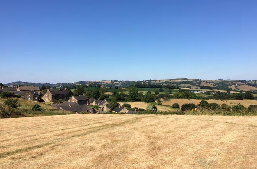
6 Community Engagement
6.01 At the Parish Council Meeting held on 4th April 2014 it was decided to write to the Planning Officer of
Derbyshire Dales District Council (DDDC) to designate the whole of Kirk Ireton Parish as a
Neighbourhood Plan area. Notice of this designation was given by DDDC on 5th Sept 2014.
6.02 The first public meeting was held on 19th February 2015
and was attended by 70 members of the village.
6.03 There was overwhelming support at the meeting for
producing a Neighbourhood Plan for Kirk Ireton.
Villagers were invited to be part of a Steering
Committee and several Working Groups.
6.04 The children from the village school produced posters
and descriptions of how they saw the village in the
future as part of a school project based on the local
area.
6.05 The Steering Committee worked closely with the Parish Council and has been guided throughout by
Rural Action Derbyshire. The Steering Group adopted a constitution and applied for a grant to
support the project.
6.06 At Kirk Ireton Village Wakes on 6th June 2015 the Steering Committee had an information stall with
details about the progress of the plan so far on display. Members of The Committee were also on
hand to answer questions about the plan. Several more villagers were recruited to join in the
Working Groups.
6.07 For the creation of the Plan to be as inclusive as possible meetings were open to all and advertised in
the Village Diary. A website was set up to make the progress of the plan easily accessible to all the
village.
6.08 The working groups met monthly and gathered information on their three areas of interest.
Built Environment Group focused on the main village settlement using the Conservation Area
Appraisal. They made detailed analysis of the age, type and design of the individual properties
in the settlement.
Amenities Group considered the range of the village amenities including the school, shop, pub,
village hall, village field, open space, church, chapel, Kirk Ireton Community Association (KICA).
Natural Environment Group investigated all the ground within the Parish Boundary. This
included farmland and agriculture, footpaths, woodland and wildlife. They also looked at the
contribution made to the village economy by tourism.
6.09 This information was presented regularly to the Steering Committee and at the second public
meeting held on 12th Oct. This meeting was attended by over 100 members of the village who were
encouraged to leave comments and questions for the Steering Committee.
6.10 Using the information gathered and comments from the public meetings the Steering Committee
created a questionnaire to go out to all the households in the Neighbourhood Area. Younger
members of the community were encouraged to give their views.
6.11 Three hundred questionnaires were delivered and 174 returned. The results were collated and
analysed and the evidence base was used to support the formation of the policies within The Kirk
Ireton Neighbourhood Plan.
6.12 The draft copy of the Neighbourhood Plan was presented in a two day ‘Open Weekend’ in the Village
Hall on the 4th & 5th Nov 2017. More than 70 villagers attended the meeting over the two days.
After further consultations with interested parties, in accordance with Regulation 14 of the
Neighbourhood Planning (General) Regulations 2012, the Neighbourhood Plan was published for pre
-submission consultation between 19th November 2018 and 2nd February 2019.
6.13 More detail can be found on community engagement in the Consultation Statement available at
https://www.derbyshiredales.gov.uk/images/documents/K/KI_NP_Consultation_Statement_&_Appendices.pdf
Page 8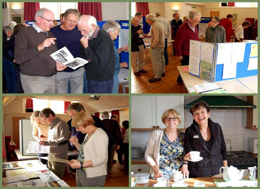
7 The Kirk Ireton Community Vision
From consultation with the community of Kirk Ireton the following vision of where we want
                      our community to be in 2033 was developed:

8.01   Kirk Ireton will be an active rural community with a balanced population
       comprising mixed ages. Village amenities will include a thriving school, a well
       supported shop and village pub, church, chapel, a village hall capable of providing
       the facilities expected of a modern village and the issue of adequate off-street
       parking will have been addressed.
8.02   The village’s heritage, including the surrounding countryside, views, open spaces
       and recreational facilities will have been preserved and enhanced where possible.

                                         Page 9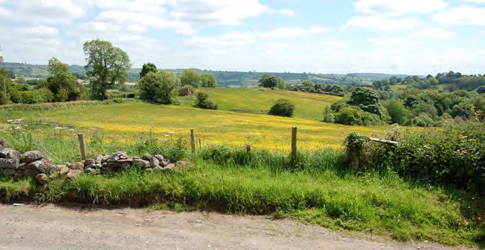
Policies
All policies should be read in conjunction with the Derbyshire
            Dales District Council’s adopted policies.
 No Neighbourhood Plan policy will be applied in isolation;
          account will be taken of all relevant policies.

                            Page 10
Policy P1 – Development
Development proposals for the village of Kirk Ireton must be appropriate for a rural location and
demonstrate particular attention to two important documents (and successor documents) that
address the character of the settlement and its setting:
Conservation Character Appraisal 2014
www.derbyshiredales.gov.uk/kinpconservationcharacterappraisal
Landscape Sensitivity Study 2015
www.derbyshiredales.gov.uk/kinplandscapesensitivitystudy
Objectives
To meet local housing need within the existing built framework
To protect the historic nature of Kirk Ireton.
To retain the quiet and safe environment.
To retain views and vistas both from and of the village.
Engagement with the Community
Questionnaire July 2016 & Open Meetings/Events between 2015-19
P1.01 The Kirk Ireton Neighbourhood Plan distributed a questionnaire in April 2016. The information was
collated over the following weeks and published in July 2016 before the adoption of the Derbyshire Dales
District Local Plan of 7th December 2017.
Full analysis of the Questionnaire results can be seen in Appendix KINP A1
P1.02 The questionnaire results demonstrate a demand by the community for protection of the landscape and
fields surrounding the village.
In response to Q9, 71% of the community replied that they required the Kirk Ireton Neighbourhood
Plan to adopt the Settlement Framework Boundary from the 2012 Draft Local Plan in order to
protect the green field sites outside this boundary.
94% of respondents said that views to and from the village should be protected.
When asked what they liked about living in the village 74% responded the “Lovely Countryside/
Views” and 80% said the “Quiet safe environment”.
When asked what worried them about future development 85% were concerned about “Loss of
green fields / Impact on views / Loss of wildlife habitat”.
In response to Q12, 83% replied that the roads into Kirk Ireton were unsuitable to support
significant further development within the village.
P1.03 Three open events were held in the village hall after the questionnaire. They were held on 10th Oct 2015, 4
& 5th Nov 2017 & 26th Jan 2019. A map displaying the existing built framework and associated ideas for a
policy and subsequent adoption was shown at all events and received widespread support.
Conservation Area Character Appraisal December 2014
P1.04 Page 37 of the Kirk Ireton Conservation Area Character Appraisal states:
“Kirk Ireton remains a relatively secretive place on its approach, ‘tucked’ away to the east of Carsington
Reservoir. Travellers suddenly emerge from the sunken and narrow lanes into the ‘heart’ of this
attractive village.” And:
“Kirk Ireton is situated on high ground close to the watershed of the River Ecclesbourne to the east and
the Scow Brook (Carsington Reservoir) to the west. North to south it extends along the 200 metre
contour. Properties enjoy expansive views across the Ecclesbourne valley as ground falls quite steeply
away to the east of Nether Lane and Bottom Lons.”
1
https://www.derbyshiredales.gov.uk/images/K/KINP_Survey_Results_2016.pdf
Page 11P1.05 On page 38 it states that from the eastern approach along Hob Lane:
“the built development of the village is most apparent.”
The village has:
“A core of traditional historic buildings surrounded by a much wider historic landscape.”
And:
“Views from the settlement especially from the east and north are out across an attractive agricultural
landscape. The area is overtly rural – the village is surrounded by agricultural land, with fields bordered
by trees and hedgerows.”
P1.06 In November 1992 the Conservation Area was reviewed and considerably extended. This was triggered by
a request from the Parish Council to recognise the wider setting of the Conservation Area and protect
views from vantage points both into and from the village.
In consulting with Derbyshire County Council and the County Archaeologist it was recognised (Page 61)
that:
“The landscape surrounding the village contributes very strongly to its special character, but is
noteworthy in its own right as a very clear survival of a landscape shaped by mediaeval farming
practice. The surviving pattern of field boundaries, sunken lanes and footpaths reflect the pre enclosure
landscape and the extent of species rich hedgerows indicates the considerable age of the hedgerow
boundaries in many instances. It is felt that the landscape is of such importance in terms of its own
historic and visual quality, as well as in terms of its contribution to the settlement framework, that
parts of it merit inclusion within the conservation area.”
P1.07 In 2012 the Derbyshire Dales District Council commissioned a new Local Plan in response to the central
government National Planning Policy Framework. The Government Inspectorate rejected the subsequent
Pre-Submission Draft Local Plan in October 2014. The Derbyshire Dales District Council withdrew the Draft
Local Plan and engaged in a further and extensive evidence base consultation. This process included the
commissioning of a ‘Landscape Sensitivity Study’ from Wardell Armstrong and a ‘Settlement Hierarchy
Assessment’.
Landscape Sensitivity Study August 2015 (see map on page 18)
P1.08 The Executive Summary in the Landscape Sensitivity Report by Wardell Armstrong stated: “The aim of the
study is to assess the sensitivity of the landscape surrounding settlements to housing development.”
The study used the Kirk Ireton Settlement Framework Boundary from the 2012 Draft Local Plan to denote
the ‘built’ area of the village. It assessed the suitability for development of each field outside of this
boundary but within the 1992 conservation area, classifying each field as either high, medium or low
sensitivity to development.
P1.09 The Sensitivity Study referenced the ‘Guidelines for Landscape and Visual Impact Assessment’, Third
Edition, published by Routledge (2013). The publication sets out “the methodology for assessing the
sensitivity of particular types of development, relating to susceptibility to change and landscape value.”
The guidelines attach great importance to public and private views stating in 3.20 that “In most cases it
will be essential to give detailed consideration to both:
effects on the landscape as a resource (the landscape effects); and
effects on views and visual amenity as experienced by people (the visual effects).
P1.10 The Landscape Sensitivity Study ‘Description and Analysis’ of Kirk Ireton on page 55 states:
6.4.30 Kirk Ireton is rural in character, with narrow winding roads and a wooded character created
by strong tree belts and woodland blocks. All approaches to the settlement are rural, and land
immediately surrounding the settlement predominantly comprises smaller fields enclosed by
tree belts, forming a vegetated edge. The village and surrounding land is located within the
Kirk Ireton Conservation Area.
6.4.31 Land to the east of the settlement slopes down away from Kirk Ireton with high visual
prominence, and is an important approach into the settlement, with open views framed by
Page 12woodland blocks.
6.4.32 The north-eastern settlement edge is well-defined but urban. However the majority of land
beyond this edge is enclosed by vegetation, and tree belts to the north screen long distance
views. Additional planting on the boundaries of these fields could reduce the visual
prominence of this land further, in addition to creating a vegetated edge to the settlement.
6.4.33 Land to the south-west of the settlement is enclosed by hedgerows and tree belts, and is
located within the settlement pattern.
6.4.34 Remaining land surrounding the settlement, particularly to the east, contributes to the rural
character of and approaches to, the settlement.
It concludes:
6.4.35 The field to the east of Hardings Close is of low sensitivity and the adjacent fields to the east
are of medium sensitivity. The field west of Wirksworth Road is also of medium sensitivity.
Small fields adjacent to the south-western edge of the settlement, north and south of
Blackwall Lane, are of low sensitivity. All remaining land surrounding the settlement is of high
sensitivity.
P1.11 An analysis of the Landscape Sensitivity Plan of Kirk Ireton (see page 18) published with the report reveals
that 85% of the fields surrounding the village were judged to be of high sensitivity, having a: “low capacity
to accommodate change such as built environment”, and therefore unsuitable for development.
Two small areas, consisting of three fields, were judged to be of medium sensitivity and three small areas,
consisting of five fields and part of one further field, were judged to be of low sensitivity. These sites are
to the north and west of the village.
‘Call for Sites’ (late 2015) & Strategic Housing and Employment Land Availability Assessment (SHLAA) August
2016:
P1.12 In late 2015, after the publication of the Landscape Sensitivity Study, Derbyshire Dales District Council
made a “call for sites”, to which land could be submitted for assessment as to suitability for future
development. Independently three sites, in and around Kirk Ireton, were submitted for assessment. They
were examined and subsequently reported on in the ‘Strategic Housing and Employment Land Availability
Assessment’ (SHLAA), which was published in August 2016. The SHLAA included ‘landscape’ but also
covered a much wider range of assessment criteria including flood risk, historic environment,
contamination, highway infrastructure, public transport, services, brownfield status and other measures.
P1.13 Two submitted sites - the field to the east of Hardings Close (SHLAA 184) and the small field adjacent to
the south-western edge of the village, south of Blackwall Lane (SHLAA 219) - that had been assessed as
low sensitivity in the Landscape Sensitivity Study, were determined to be ‘undevelopable’ by the SHLAA.
The third site, Smithy Bungalow (SHLAA 476) was within the Settlement Boundary. It was considered that
25% of this site was ‘developable’.
There is a remaining area of land situated to the west of Main Street and north of Blackwall Lane which
was designated as low sensitivity in the Landscape Sensitivity Survey but was not submitted in the ‘Call for
Sites’.
Settlement Hierarchy Assessment October 2015:
P1.14 The Settlement Hierarchy Assessment (3.19)states:
“If a settlement is surrounded by landscape of high sensitivity then it has low capacity to
accommodate change such as built environment.”
The introduction (1.2) of the Settlement Hierarchy Assessment states:
“In considering where new development should be located, there is a need to balance the
requirements of development against other needs such as sustainability and environmental impacts.
Development needs to be accommodated in settlements where the need to travel can be reduced
through good access to facilities and services and where it can be accommodated without significant
adverse impacts.”
It also (3.18) states:
Page 13“Considerable weight has been attached in this Assessment to the findings of the Landscape
Sensitivity Report produced for the District Council by consultants Wardell Armstrong.”
P1.15 The Settlement Hierarchy Assessment considered the suitability of 24 settlements for future development.
The main factors considered were economic (employment opportunities), environmental and the
availability of social/community facilities. Kirk Ireton was placed 23rdout of the 24 settlements. The
settlements were then graded into five tiers, 1 to 5. Tier 1 contained settlements considered most suitable
for future development. Tier 5 contained settlements considered least suitable for future development.
Kirk Ireton was placed in tier 5 as the village was judged to be unsuitable for significant development.
The Settlement Hierarchy Assessment introduction (1.3) states:
“At the bottom of the hierarchy are settlements, which have relatively few functions, less
infrastructure and are more isolated in terms of transport links.”
The study concludes (4.14) that:
“In line with the overall aim of planning to contribute to sustainable development, the spatial
strategy in the new local plan should seek to guide the majority of new development to the higher
tiered settlements. This may be achieved by trying to facilitate higher growth rates in each
successive tier, so that the lowest growth rates occur in Tier 5 and the highest growth rates in Tier
1.”
The Inspector’s Report 13th November 2017 & Main Modifications
P1.16 The draft Derbyshire Dales Local Plan was examined by Mark Dakeyne BA (Hons) and the Inspector’s
Report was published on 13th November 2017:
Page 9 40. of the Inspector’s Report states:
“The 4th and 5th tier villages do not have settlement boundaries but Policy S3 as worded does allow
limited development to support existing services through infill and consolidation. However, there is a
lack of consistency between the explanation and the policy itself and not enough clarity as to the
type of development that might be acceptable. MM4 provides that necessary effectiveness,
consistency and guidance by referring to infill and consolidation at an appropriate scale, brownfield
sites on the edge of settlements and affordable housing exception sites.”
P1.17 Main Modification 4 on page 7 of the Inspector’s Report clarified Derbyshire Dales District Council
development policy towards 4th and 5th tier villages and was published in S2 of the Derbyshire Dales
District Council Local Plan 7th December 2017. It states:
“In all cases, development should be commensurate with the scale and function of the settlement,
can be accommodated through infill and consolidation of the existing built framework of the
settlement or is well related to the existing pattern of development and surrounding land uses;
would not lead to prominent intrusion into the countryside; or constitutes exception sites affordable
housing (Policy HC5).”
Derbyshire Dales Local Plan 7th December 2017
P1.18 The Derbyshire Dales Local Plan adopted on the 7th December 2017 changed the classification of Kirk
Ireton from Tier 5 in the Settlement Hierarchy Assessment October 2015 to Tier 4. It describes the group
of six villages in Tier 4 as “Accessible Settlements with Minimal Facilities”.
S2 of The Local Plan states:
“Accessible Settlements with Minimal Facilities – Fourth Tier
Accessible Settlements with minimal facilities are defined as settlements with a very limited range of
employment, services and facilities. Small villages have a low level of services and facilities and few
employment opportunities. Development will therefore be limited to that needed to help maintain
existing services and facilities and to meet the housing needs of the settlement. As such there is
some limited scope for development within these settlements.”
4.20 of The Local Plan states:
“Whilst it is recognised that in these villages there is a need to meet local needs for housing and
other economic or community purposes these villages generally have a very limited range of services
and facilities and it is often necessary for local residents to travel outside the village for most of their
daily needs. Development on a large scale would be unsustainable in these villages, as this would
Page 14generate a disproportionate number of additional journeys outside the villages and undermine the
spatial strategy.”
And 4.72:
“The strategy for the Rural Parishes is to ensure that new development does not have any significant
adverse impact upon the character and appearance of these villages, and the surrounding
countryside.”
This will be achieved by Policy S9 a) - Rural Parishes Development Strategy:
protecting the open countryside and high quality environment from inappropriate development;
protecting and enhancing the historic environment of rural villages.
P1.19 Kirk Ireton does not have a housing target to meet the Derbyshire Dales District Council housing need.
Conclusion
P1.20 This policy offers protection to the highly sensitive landscape surrounding the village as described in the
Kirk Ireton Conservation Area Character Appraisal, the Landscape Sensitivity Study, the responses to the
village questionnaire and the feedback from the community at village open events.
Page 15Map showing results of the Kirk Ireton Landscape Sensitivity Study
Map source: Wardell Armstrong August 2015 Landscape Sensitivity Study for DDDC
Page 16Policy P2 - Protecting Views
Development proposals should not be detrimental to views of the village, views from the village or
the heritage value of the landscape. The potential impact on views should be assessed and
addressed by taking into account the sensitivity of land to development as identified in the
Landscape Sensitivity Study and also the principles within and views highlighted by the Conservation
Area Character Appraisal.
P2.01 “Kirk Ireton is situated on high ground close to the watershed of the River Ecclesbourne to the
east and the Scow Brook (Carsington Reservoir) to the west. North to south it extends along the
200 metre contour. Properties enjoy expansive views across the Ecclesbourne Valley as ground
falls quite steeply away to the east of Nether Lane and Bottom Lons.”
Source: Kirk Ireton Conservation Area Appraisal*.
Objective
P2.02 To protect the valued views of the village from the surrounding countryside and the views from
the village to surrounding countryside in all directions.
Village Data
P2.03 Full Analysis of the Questionnaire results can be seen in in Appendix KNIP A2.
The majority of respondents to the Questionnaire regarded the ‘Lovely Countryside and
Views’ to be an important reason to live here.
There were a large number of concerns about the effects of future development on the
environment including Loss of Green Fields, Impact on Views and Loss of Wildlife Habitat.
The majority of respondents said we should keep the current settlement boundary in order
to discourage development on greenfield sites
Supporting Material:
P2.04 Derbyshire Dales District Council contracted Wardell Armstrong to produce a ‘Landscape
Sensitivity Study’ of settlements within their district which was published August 2015.
Wardell Armstrong carried out a review in line with the methodology set out in the Guidelines for
Landscape and Visual Impact Assessment – produced by the Landscape Institute and The Institute
of Environmental Management Assessment. Their landscape and visual impact team regularly
contribute to the preparation and review of environmental statements and environmental
appraisal.
The aim of the study was to assess the sensitivity of the landscape surrounding settlements to
housing development and provide a strategic context for landscape capacity and impact
assessments undertaken at field level, and form part of the evidence base for the Local Plan.
The view across the
Ecclesbourne Valley from
Nether Lane
The Conservation Area
Appraisal can be viewed
here:
www.derbyshiredales.gov.uk/
kinpconservationcharacterapp
raisal
2
https://www.derbyshiredales.gov.uk/images/K/KINP_Survey_Results_2016.pdf
Page 17Policy P3 - Conservation Area
Development proposals within the Conservation Area should promote, reinforce and enhance the
area’s local distinctiveness and be sensitive to the heritage context in terms of design, materials,
scale, massing, density, light pollution and access. The guidelines within the Kirk Ireton Conservation
Area Character Appraisal must be addressed. Particular attention should be paid to any impacts on
principal landmarks as identified on the adjacent map and its key.
P3.01 “The original reasons for the designation of Kirk Ireton as a Conservation Area are still
considered as pertinent now as in 1972 and 1992. New development within or adjacent to The
Conservation Area could potentially harm the area and inappropriate development could easily
harm the scale and balance in the relationship of settlement to Landscape.’’
Source: Kirk Ireton Conservation Area Appraisal
Objective
P3.02 This policy is to protect the whole of the Kirk Ireton Conservation Area from inappropriate
development.
What is a Conservation Area?
P3.03 Following concerns that the special qualities of areas were being lost by post-war development,
the 1967 Civic Amenities Act introduced the concept of a ‘Conservation Area’. Section 69 of the
Planning (Listed Buildings and Conservation Areas) Act 1990 gives local Councils the power to
designate a Conservation Area within their local planning area. A Conservation Area is ‘an area of
special architectural or historic interest, the character or appearance of which it is desirable to
preserve or enhance’.
The Kirk Ireton Conservation Area
P3.04 In 1971 Kirk Ireton was designated a Conservation Area. At that time, the boundary was drawn
quite tightly around the built development which formed the core of the village.
P3.05 In November 1992, the Conservation Area was reviewed and extended considerably. This was
triggered by a request from the Parish Council who considered that the village had suffered
considerable pressure for development, much on the edges of the existing Conservation Area and
that it was important to recognise the wider setting of the Conservation Area and protect views
from vantage points both into and from the village.
P3.06 Conclusion to the Conservation Area Character Appraisal December 2014
“The current Conservation Area boundary, as established in 1992 generally follows physical
boundaries on the ground, such as existing field patterns and public footpaths. The 1992
boundary identified a much wider agricultural setting for the core of the village and
recognised the importance of the wider historic landscape. It is therefore not proposed to
amend, either by further inclusion or reduction, the existing boundary.”
Village Data from the Questionnaire:
P3.07 Response to the Village Questionnaire (see Appendix KNIP A3) showed that the majority:
Were aware of the Conservation Area status of the village and say that this Plan should
adopt its principles.
Stated that new houses and extensions should be in sympathy with the surroundings
Had concerns about future development in the village expressing concerns about
development which was out of character.
3
https://www.derbyshiredales.gov.uk/images/K/KINP_Survey_Results_2016.pdf
Page 18Development within the Kirk Ireton Conservation Area
P3.08 Any development must conserve and enhance the character of the Conservation Area. It should
respect the nature, scale, design and materials found in the area and be in keeping with the
special qualities of the defined character documented in The Conservation Area Character
Appraisal.
P3.09 The landmark properties in the village should be respected.
P3.10 This Plan supports the findings of the Kirk Ireton Conservation Area Character Appraisal which
suggests the following (except in exceptional circumstances or when a compelling case is made in
support of good design):
P3.11 Guidelines
i. The general pattern of buildings on Main Street is two storeys high with narrow frontage.
This should be maintained.
ii. The size of properties in relation to neighbouring properties and the size of the plot are
important. The construction of buildings which are too big for the plot and which are
disproportionate to surrounding houses should be avoided.
iii. The agricultural character of outbuildings should be preserved and encouraged.
iv. Houses should be built of warm pink/orange local sandstone with coursed squared blocks
with tooled finish and natural coloured mortar.
v. Roofs should be Staffordshire Blue clay tiles or stone slates at a suitable pitch. Gables
should have mortared verges or stone copings.
vi. Extensions to existing properties should be constructed of materials which match the
existing. There should be careful introduction of buildings and structures (for example,
sheds, garages, garden rooms, garden studios, pergolas, raised decking) within building
curtilages which are visible to the public and could have a potential negative impact on the
character and appearance of the Conservation Area.
vii. Porches and conservatories may have an impact on historic buildings and the Conservation
Area. Their appropriateness to the period, type and style of the original building is
important as is their size, form, mass, scale and their construction materials.
viii. Generally there should be a high proportion of wall to window/door openings
ix. The replacement of windows and doors should be with appropriate materials to discourage
the use of UPVC windows and doors, especially in old properties.
x. Solar panels, satellite dishes and street furniture should be sited thoughtfully. The potential
impact of external appendages to properties – such as meter boxes, flue pipes, boiler flues
outlets and cables, can be mitigated through careful consideration of their colour and finish
and their location on a building.
xi. Any loss or unnecessary alterations to stone walls should be avoided. Boundary walls gates,
gateposts and railings etc. to properties in all parts of the Conservation Area are important
where they provide a visible and physical presence of enclosure to the road ways, tracks
and footpaths. The consequences of their removal, in whole or in part, or their alteration or
re-construction in non-traditional materials can have a detrimental effect on their setting.
xii. New or replacement gates, gate posts and railings to properties should be appropriate to
their context in form and scale, and be made of materials which relate to the tradition of
such elements within the street scene.
xiii. Hard surfacing materials for driveways, paths etc. to properties where these are visible to
the public should have hard surfacing of traditional materials which complement the rural
and historic character and appearance of the Conservation Area. The visual and physical
impact of areas of modern paving of an inappropriate colour or texture can have a
significant impact on the character and appearance of the Conservation Area.
Page 19Page 20
Map showing the Kirk Ireton Conservation Area

Source www.derbyshiredales.gov.uk/kinpconservationcharacterappraisal
                                                     Page 21
Policy P4 - Business Development
Business and tourism developments that demonstrate appropriate regard for the rural
character and rural infrastructure of the Neighbourhood Area will be supported.
Objective
P4.01 To encourage suitable business development in the Neighbourhood Plan area.
Village Data:
P4.02 The two most popular answers to ‘What do you like about living here?’ were: “Quiet, safe
environment” (80%), “Lovely Countryside/Views” (74%).
There was concern that development would increase traffic on unsuitable roads, exacerbate parking
problems and affect the unique environment of the village and its surrounding countryside.
Full analysis of the results from the questionnaire is shown in Appendix KINP A4
Background
P4.03 The roads that connect the village of Kirk Ireton to the nearest ‘A’ roads are too narrow and poorly
maintained to support an increase in the volume of traffic, particularly larger vehicles, that would be
associated with significant commercial development.
4.04 The NPPF states in paragraph 83 “planning policies and decisions should enable the sustainable
growth and expansion of all types of business in rural areas, both through conversion of existing
buildings and well-designed new buildings; the development and diversification of agricultural and
other land based rural businesses; and sustainable rural tourism and leisure developments which
respect the character of the countryside and the retention and development of accessible local
services and community facilities…”
P4.05 The Derbyshire Dales Local Plan supports the appropriate development of tourism and culture (Policy
EC8).
Tourism plays a significant part in the local community including:
Caravan & camping sites Equestrian centre
Cycling routes Garden visits (National & local events)
Bed and breakfast accommodation Holiday cottages
Destination “Real Ale” pub Rambling
Carsington Water activities Wakes week festival
Other potential activities:
Rural craft workshops Exhibition space for artisans and local artists.
Plant Nursery Café/Tea Room for walkers, cyclists, etc.
Pub with food Historic tours
Compliance with the Derbyshire Dales Local Plan
P4.06 This Plan supports the following policies in the Derbyshire Dales Local Plan
Page 50: 4.72 states that: The strategy for the Rural Parishes is to ensure that new development does
not have any significant adverse impact upon the character and appearance of these villages, and the
surrounding countryside.
Policy S9: Rural Parishes Development Strategy will be achieved by; “protecting the open countryside
and high quality environment from inappropriate development; protecting and enhancing the historic
environment of rural villages.”
Page 112 Policy EC8 “Where development (excluding chalet accommodation, caravan and camp site
developments), accords with any of the principles listed above, it will be permitted if:
a) the scale and nature of the activity are appropriate to its location;
b) it supports sustainable rural tourism;
c) the location is capable of accommodating increased numbers of visitors without detriment to
road safety or congestion;
d) there is no detrimental impact on the character of the local landscape and/or nearby
settlements.”
4
https://www.derbyshiredales.gov.uk/images/K/KINP_Survey_Results_2016.pdf
Page 22Policy P5 - Parking
a) Subject to the provisions of the Town and Country Planning (General Permitted Development)
(England) Order 2015 (or any order revoking and re-enacting that Order with or without
modification) developments within the village which propose to remove recognised off-road
parking spaces (such as driveways or garages) will be required to make alternative provision
which increases or maintains the number of accessible parking spaces available on or within
the immediate vicinity of the site.
b) Any opportunities that arise to enhance parking provision throughout the village will be
supported.
Objective
P5.01 This policy is to ensure that any new development does not have a detrimental effect on the
already stretched parking facilities in the village.
Supporting Information & Data
P5.02 The village questionnaire highlighted the fact that many people in the village say there is a
problem with parking and were concerned that additional development in the future could
exacerbate this. Most original village cottages do not have any off-road parking facilities. This is
particularly obvious along the Main Street which is fully occupied with cars along one side.
P5.03 The village car park on Main Street is often full with residents’ and visitors’ cars. Neither the
village hall, school, shop, church or chapel have any parking spaces which puts further stress on
the limited parking facilities in the village.
P5.04 Residents need to travel out of the village for work, education, shopping and leisure. There is a
lack of public transport. As a result many properties have two, three or in some cases even four
cars. The Rural Place Profile5, created by OCSI using the 2011 census, states on page 35 that in
Kirk Ireton 44.2% of households (90 out of 205) have two cars against a national average of
24.7%. These are the most up to date figures available - however it is likely that the percentage
of two-car households in the village has risen since the census was taken six years ago.
P5.05 The Rural Place Profile also states that the average travel to hospital from Kirk Ireton by public
transport is sixty minutes against a County average of thirty nine minutes. Sixty minutes would
actually be extremely hard to achieve. These figures illustrate why villagers are so reliant on cars.
5
Rural Place Profile Oct 2013
https://www.derbyshiredales.gov.uk/images/K/KI_NP_Rural_Place_Profile_Oct_2013.pdf
Page 23Acknowledgements
Thanks are expressed to residents of the Kirk Ireton Parish for their help and enthusiasm in
producing this Neighbourhood Plan, in particular members of the working groups, steering
committee and editorial group.
Thanks also to:
Kirk Ireton Parish Council
Joe Dugdale, Rural Action Derbyshire
Mike Hase, Planning Policy Manager, Derbyshire Dales District Council
Editorial Group Steering Group
Nick Delves (Chair) Tony McLennan (Treasurer)
Maurice Coey Gill Lockett (Secretary)
Jan Hall Jeremy Butt
John Kippax
Irene Dougan
Radford Neville
Penny Glendinning
Niamh Goulder
Neville Taylor
Page 24You can also read