Revised stratigraphy of the Hazelton Group in the Iskut River region, northwestern British Columbia
←
→
Page content transcription
If your browser does not render page correctly, please read the page content below
Revised stratigraphy of the Hazelton Group in the
   Iskut River region, northwestern British Columbia

   JoAnne Nelson1, a, John Waldron2, Bram van Straaten1, Alex Zagorevski3,
   and Chris Rees4
   1
     British Columbia Geological Survey, Ministry of Energy, Mines and Petroleum Resources, Victoria, BC, V8W 9N3
   2
     Department of Earth and Atmospheric Sciences, University of Alberta, Edmonton, AB, T6G 2E3
   3
     Geological Survey of Canada, Ottawa, ON, K1A 0E8
   4
     Imperial Metals Corporation, Vancouver, BC, V6C 3B6
   a
     corresponding author: JoAnne.Nelson@gov.bc.ca

   Recommended citation: Nelson, J., Waldron, J., van Straaten, B., Zagorevski, A., and Rees, C., 2018. Revised stratigraphy of the Hazelton
   Group in the Iskut River region, northwestern British Columbia. In: Geological Fieldwork 2017, British Columbia Ministry of Energy, Mines
   and Petroleum Resources, British Columbia Geological Survey Paper 2018-1, pp. 15-38.

   Abstract
      The Iskut River region hosts many significant porphyry, precious-metal vein and volcanogenic massive sulphide deposits. Most of these
   deposits are related to the Hazelton Group (latest Triassic to Middle Jurassic) and affiliated intrusions. Current knowledge of the Hazelton Group
   is the outcome of piecemeal, local mapping contributions over many years by different workers at different scales, resulting in inconsistencies
   and errors in stratigraphic nomenclature. Given that exploration interest in the region remains high, and that considerable work has recently
   been done in the region, a reappraisal of this nomenclature, applying provisions in the North American Stratigraphic Code is required. In
   our new stratigraphic framework, newly recognized units are given local geographic names; others are correlated with previously established
   units. Two newly defined lowermost Hazelton units, the Klastline formation (new informal name) and the Snippaker unit, are latest Triassic,
   showing that earliest Hazelton volcanism and sedimentation were coeval with formation of the Red Chris porphyry deposit. These, along with
   siliciclastic rocks of the Jack Formation (Lower Jurassic) and mainly andesite successions such as the Betty Creek Formation, comprise the lower
   Hazelton Group. The upper Hazelton Group includes the Iskut River Formation (mainly Aalenian-Bajocian) comprising the bimodal volcanic-
   sedimentary succession within the Eskay rift that hosts the Eskay volcanogenic massive sulphide deposit; mainly sedimentary units such as the
   Spatsizi Formation and Quock Formation that occur throughout central Stikinia; the Mount Dilworth Formation, a stratified Middle Jurassic
   felsic volcanic unit that occurs outside but near the Eskay rift; and the Eddontenajon formation (new informal name), an unusual Pleinsbachian-
   Toarcian bimodal volcanic-sedimentary sequence that outcrops near the hamlet of Iskut.

   Keywords: Iskut, Stewart, Golden Triangle, Hazelton Group, Iskut River Formation, Betty Creek Formation, Snippaker unit, Klastline
   formation, Eddontenajon formation, Unuk River andesite unit, Brucejack Lake felsic unit, Johnny Mountain dacite unit, Willow Ridge mafic
   unit, Bruce Glacier felsic unit, Mount Madge sedimentary unit, Downpour Creek siliciclastic unit, Palmiere dacite-mudstone unit, Mount
   Dilworth Formation, Spatsizi Formation, Quock Formation, Triassic, Jurassic, Stikinia

   1. Introduction                                                             phase in Stikinia before and during the onset of collision with
     The Iskut River region, between Stewart and Iskut (Fig. 1),               Laurentia (Nelson et al., 2013). It is distributed throughout the
   hosts many significant porphyry, precious-metal vein and                    region (Figs. 1, 3; Ash et al., 1997a; Lewis 2001, 2013; Alldrick
   volcanogenic massive sulphide (VMS) deposits. Mining                        et al., 2006); coeval and cogenetic intrusions of the Texas
   commenced at the Red Chris porphyry Cu-Au deposit in 2015,                  Creek plutonic suite (ca. 195-186 Ma; Anderson, 1993) are also
   and at the Brucejack (Valley of the Kings) gold deposit in                  widely distributed . The Hazelton Group includes all volcanic
   2017. Deposits comparable to the past-producing Eskay Creek                 and sedimentary strata that lie above the Stuhini Group (Upper
   precious-metal VMS orebody remain targets of exploration                    Triassic) and below Upper Jurassic to Lower Cretaceous
   interest. Past-producing gold mines at Premier, Snip, and                   synorogenic siliciclastic rocks of the Bowser Lake Group.
   Johnny Mountain are currently being reassessed for additional               Tipper and Richards (1976) defined the Hazelton Group from
   resources (Fig. 2). Significant developed prospects include the             work near Smithers, and subdivided it into formations based
   Kerr-Sulphurets-Mitchell-Iron Cap (KSM) porphyry Cu-Au,                     on the relative abundance of volcanic and non-volcanic rocks,
   the GJ porphyry, and porphyry and precious metal targets in                 and subaerial and submarine facies. Since then, significant
   the Snippaker Mountain-Johnny Mountain area (Fig. 2).                       advances in our understanding of the Hazelton Group have
     Most deposits in the Iskut region are related to the Hazelton             been made through detailed mapping, geochronology, and
   Group (latest Triassic-Middle Jurassic) and affiliated intrusions.          biochronology. For example, Tipper and Richards (1976)
   The Hazelton Group represents the final arc construction                    considered that the Hazelton Group is entirely Early Jurassic,

                                                                          15
Geological Fieldwork 2017, British Columbia Ministry of Energy, Mines and Petroleum Resources, British Columbia Geological Survey Paper 2018-1
Nelson, Waldron, van Straaten, Zagorevski, and Rees

   Fig. 1. Regional setting of the Iskut River study area.

                                                                         16
Geological Fieldwork 2017, British Columbia Ministry of Energy, Mines and Petroleum Resources, British Columbia Geological Survey Paper 2018-1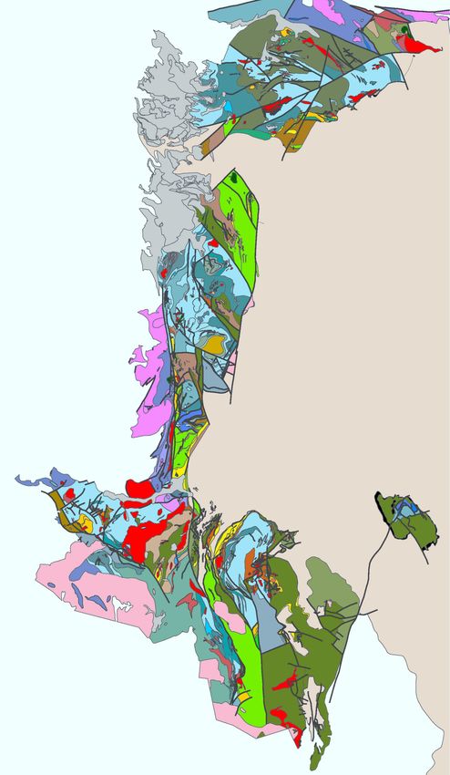
Nelson, Waldron, van Straaten, Zagorevski, and Rees
! #
+
.
1
$
2
. $
$ 344
!
$
' (
+
%
&
$
&-.&
& ,
0
0
)*
!
*
'
0
2 '
" 5667
! 0 !
''
+ )
0
+ *
+
+ /
0
/
0
/
$
1 $
563
,
#
&
"
"
$
$..8*
" & *
"
+
& ,
" &
( $
&#
'(
! "
# $ %
96+
8
Fig. 2. Geography of the Iskut River region, showing mines, major projects, and key geological features. Areas covered by principal existing
geological sources (Lewis, 2013; Alldrick et al., 2006; Ash et al., 1997a, b) are shown for reference.
17
Geological Fieldwork 2017, British Columbia Ministry of Energy, Mines and Petroleum Resources, British Columbia Geological Survey Paper 2018-1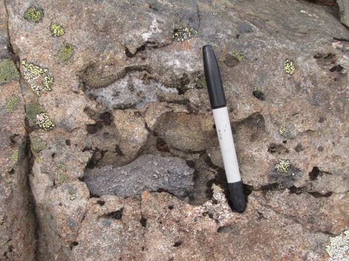
Nelson, Waldron, van Straaten, Zagorevski, and Rees


                                                                                                                          ) .
                                                                                                                                  !

                                                                                                                                             ) !


                                                                                                         !


                                                                                                  "


                                                               )--

                                                                                                                ( )


                                                                                ,

                                                                                                     12
                                                                             ,


                                                                                $ * ,


                                                                                /!  0


                       **

                                                                                                                                                        #
                                                   %
                                                  ,                                                                                                  $%


                                                                                                                  %

                      +&
                      +&


                                                  '


                                                                                                                                               !


                                                                                                                                                                       12


                                                                                                                          $  &


                                                                                                                          %'
                                                                                                                           %'


                                                                                                                                                   - !


   Fig. 3. a) Preliminary compiled geology for the Iskut River region, b) legend.

                                                                                                                                 18
Geological Fieldwork 2017, British Columbia Ministry of Energy, Mines and Petroleum Resources, British Columbia Geological Survey Paper 2018-1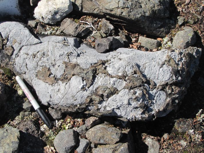
Nelson, Waldron, van Straaten, Zagorevski, and Rees
! "#"$% &'(
3"%%1$ & ,//$ "!
"'
"3++
$ "! )*+,! $ -! ) ,
7
+ .
,//$ "!
"' '! -"!-*-& "!-
$&'$-$
! *
$ 9* * .
,//$ 0, !
"'*1&2$ ' $ !'$&,
1
, @ .
! . :
5 * :
,//$ 3&
"!
"'*3"%%1$ 0, !
"'
.
% 3 '
7 6 * .
@ .
&!
.
'( ) *+
3"%%1$ "!
"'
* *
+, ) *+
$
(!) 4)&1" $ 3$35$ 6 $ ,//$ /!1$&?&"' %$;&-"!-*/$ 3"!-
5 ,'$ 71!'"$ #$1
"' ,-" 6 .
"++ *45
2"11&2 "%7$ 3!#"' ,-" 6
3 8 3!%7$
$%"3$- ! ) ,-" 6 /
("-!
(!- '&-71&3$ ! $ ,-" 6
1
%&2-/&, ' $$(
"1"'"'1!
"' ,-" 6 5 .
!
""
#$"
%
# :
" ++ ) *+
. .
1 * 9
1&2$ 0, !
"' /1$"-
5!'4"!-* &! '"!-
"- ,
";$ &'(
-G . / *+
$! 1) $ "! )
# 6 . /
7
5 6 : : /
0, !
"'A $ "! )A
7
1&2$ 0, !
"'
"-$3, "!-*/1$"-
5!'4"!-
0
) *+ 3"%%1$ 0, !
"'
% 6 . " . # @ 8
, 5 ' # . 8
, 5 ' # 5 ' % '
$! 1) & 3"%%1$ 0, !
"'
- 3 * 9 8
,-,( ";$ !-%$
" $ ,-" .
:
5 ,'$0!'( 1!($ #$1
"' ,-" /1$"-
5!'4"!-
6 : + ( , - (5 +( +3 ,(+ *
0&4--) 3 -8 %!'" $
"-$3, "!-
6 $! 1) 0, !
"'
5 ,'$0!'( 1!($
," $ 8 BCD*BEF 3
6 (* * *
. 
Nelson, Waldron, van Straaten, Zagorevski, and Rees

   but recent work by Barresi et al. (2015) showed that basal                Below we track the evolution of Hazelton nomenclature in
   volcanic rocks near Terrace are ca. 205 Ma, within the Rhaetian           the area (Fig. 4). For the most part, we follow stratigraphic
   stage (Gradstein et al., 2012; Cohen et al., 2013) of the Upper           assignments in Lewis et al. (2001a) and Lewis (2013) but with
   Triassic. In the 1990s, detailed studies of the Hazelton Group            revisions as described below (Figs. 4, 5).
   stratigraphy, spurred by the discovery and development of the
   Eskay Creek deposit, identified a heterogeneous succession                2.1. Basal Hazelton Group: Jack Formation; introduction
   of Middle Jurassic bimodal volcanic and sedimentary strata                of Snippaker unit
   in the upper Hazelton Group that differ in age and character                 Along the margins of the McTagg anticlinorium, the Stuhini
   from older, predominantly andesitic units in the lower Hazelton           Group-Hazelton Group contact is an angular unconformity that
   Group (Anderson and Thorkelsen, 1990, Lewis et al., 2001a).               is overlain by a basal conglomeratic unit (Lewis et al., 2001a,
   Recently, Gagnon et al. (2012) developed a stratigraphic                  Lewis, 2013; Nelson and Kyba, 2014; Kyba and Nelson,
   schema for the Hazelton Group throughout Stikinia, based on               2015). This basal siliciclastic unit is named the Jack Formation
   detailed studies by Gagnon (2010) and Barresi (2015). They                after exposures near the Jack Glacier (Fig. 3; Henderson et
   proposed that it consists of two divisions. The lower Hazelton            al., 1992; Lewis et al., 2001a). It was originally defined as
   Group includes basal siliciclastic units (where present) and              a wholly siliciclastic unit, identified primarily by cobble to
   andesitic to variable volcanic successions. The upper Hazelton            boulder granitoid-clast conglomerate (Fig. 6a). Quartz-bearing
   Group includes the Iskut River Formation, a distinctive unit              arkosic sandstone, granulestone, and thinly bedded siltstones
   of bimodal volcanic and interbedded sedimentary rocks that                and mudstones are also present (Fig. 6b; Nelson and Kyba,
   occupies a fault-bounded belt in western Stikinia (Fig. 1),               2014). Jack Formation sections at Bruce Glacier and Treaty
   and mainly sedimentary strata that immediately underlie the               Glacier contain andesitic volcaniclastic rocks that are in
   Bowser Lake Group throughout central and northern Stikinia.               gradational contact with identical siliciclastic strata above and
   We follow their system of nomenclature in this paper.                     below (Fig. 6c; Nelson and Kyba, 2014). Near Treaty Glacier,
      As is commonly the case when different areas within a                  ammonite collections from above the andesitic volcaniclastic
   region are studied by different workers at different scales               layer are Late Hettangian to Early Sinemurian (Nadaraju and
   over many years, errors and inconsistencies, which constitute             Lewis, 2001). Although Lewis et al. (2001a) assigned these
   conceptual barriers, have been introduced into the stratigraphic          andesitic volcaniclastic rocks to the overlying Unuk River
   nomenclature of the Hazelton Group. Because exploration                   unit, evidence of interfingering or continuity between the two
   interest in this mineral-rich area is high, and because new               is lacking, and we consider them part of the Jack Formation.
   published and unpublished data are currently being integrated             Febbo et al. (2015) and Febbo (2016) identified similar
   into the province-wide geology database (see Cui et al.,                  andesitic pyroclastic units in the Jack Formation in the KSM
   2017), a regionally consistent and stable stratigraphic scheme            deposit area.
   is required. In this paper we review key aspects of Hazelton                 The base of the Jack Formation is broadly latest Triassic
   Group lithostratigraphy, evaluate stratigraphic terms in the light        to Early Jurassic. In the Atkins Glacier area (north of Treaty
   of recent work and current understanding, and introduce a new             Glacier), a fossil collection from near the Stuhini Group-Jack
   stratigraphic framework for the Iskut River region. Our scheme            Formation contact is considered Late Norian (Crickmayi zone;
   retains some long-standing terms, abandons some obsolete                  collection 93-ATP-7, Lewis, 2013) based on the ammonite
   or ill-conceived terms, and introduces new terms following                Choristoceras(?). However, this ammonite is presently
   procedures outlined in the North American Stratigraphic Code              considered as Rhaetian (Ogg, 2012). Further work is needed
   (North American Commission on Stratigraphic Nomenclature,                 to establish a more precise age and to determine if the unit
   2005). Because the Hazelton Group displays significant                    sampled is part of the Stuhini Group rather than the Hazelton
   longitudinal variation in the region, we present our analysis             Group. A tuffaceous sandstone from the Jack Formation 2 km
   along a south-to-north transect, providing details from three             northwest of Brucejack Lake yielded ca. 197 Ma detrital
   areas: 1) Stewart-McTagg anticlinorium-Snippaker Mountain;                zircons, and a volcanic conglomerate in the overlying Betty
   2) Forrest Kerr-Ball Creek-Table Mountain, and 3) Kinaskan                Creek Formation contains a ca. 196 Ma leucodiorite clast
   Plateau-Klastline Plateau-Todagin Plateau.                                (Figs. 4, 5; J. Nelson, unpublished, 2017). These ages suggest
                                                                             that the top of the Jack Formation is mid-Sinemurian, at least
   2. Stewart-McTagg anticlinorium-Snippaker Mountain                        locally (Fig. 5). Other samples of the Jack Formation contain
   area                                                                      mainly 220-226 Ma and minor Paleozoic detrital zircon
     This area extends north from the Stewart mineral camp and               populations (J. Nelson, unpublished, 2017). Together with the
   includes the Unuk River drainage, Treaty Glacier, Snippaker               abundance of coarse-grained plutonic clasts, these distinctly
   Mountain, and Johnny Mountain (Fig. 2). It centres on the                 older populations indicate that Jack Formation deposition
   McTagg anticlinorium (Fig. 3), a regional structural culmination          represents a significant break from Stuhini Group volcanic and
   cored by Stuhini Group strata and flanked by Hazelton Group               volcaniclastic accumulation, recording deep erosion into the
   rocks. Eskay rift rocks form extensive exposures in the Unuk              Paleozoic section and Triassic Stikine suite plutons.
   River valley, bounded on the west by the South Unuk fault.                   On Snippaker Mountain, the uppermost layer of the Stuhini

                                                                        20
Geological Fieldwork 2017, British Columbia Ministry of Energy, Mines and Petroleum Resources, British Columbia Geological Survey Paper 2018-1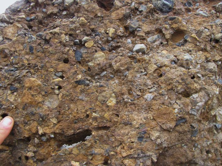
Nelson, Waldron, van Straaten, Zagorevski, and Rees
( )
+ 4 ( + 4
+ ( +
*+ ,-./01 -..23 # ( ,566-1 56-23 ( ,
"'3
& +
5
! & +
5
!
!""#
*#
2
$
(#1
, %
3
(#1 6
Nelson, Waldron, van Straaten, Zagorevski, and Rees
)" '//0$ $12$ "
,,- "-. . $ 3' $,2$# .$1
!"%
&"
' ((&"
! !
"#$ $
#%
!
!
! !
!"
#$!$$$$$ $
+$
$ ,
&
)"%"&*
!
! ! !
!
!
& #
!
!
!
$
!
!
!
! !
!
! !
!
'
!
!
!"
+$
$ ,
Fig. 5. Stratigraphic columns representing the Hazelton Group in the Stewart-McTagg-Snip area, southern Iskut River region. Numbers
reference sources for fossil and radiometric ages. 1. Norian-Rhaetian boundary (Wotzlaw et al., 2014); 2. Rhaetian-Hettangian boundary
(Schaltegger et al., 2008); 3. Hettangian-Sinemurian boundary (Schaltegger et al., 2008); 4. Cohen et al. (2013); 5. ca. 203.4 Ma youngest
detrital population (J. Nelson, unpublished data, 2017); 6. biochronologic and geochronologic compilations of Lewis et al. (2013) based on
Nadaraju (1993); Nadaraju and Lewis (2001); Lewis et al. (2001b); 7. ca. 198 Ma youngest detrital population (J. Nelson, unpublished data);
8. ca. 192 Ma U-Pb zr (J. Nelson, unpublished data, 2017); 9. Childe, 1996; 10. ca. 197 Ma, U-Pb zr (J. Nelson, unpublished data, 2017);
11. Greig (2013); MacDonald (1993); 12. 198-189 Ma U-Pb zr (Febbo, 2016); 13. ca. 186 Ma youngest detrital zircon population (J. Nelson,
unpublished data, 2017); 14. Cutts et al. (2015).
Alldrick (1987, 1993) referred to the lowest exposed Hazelton formal members (Lewis et al., 2001a; Lewis, 2013) to be
Group unit near the Salmon River, consisting of interbedded problematic. In formal stratigraphic nomenclature (see North
green andesitic volcaniclastic and sedimentary strata, as the American Commission on Stratigraphic Nomenclature, 2005)
Unuk River Formation. The name Unuk River was derived a member is defined as a single unit with a defined bottom
from earlier assignment of volcanic rocks in the Unuk and top. In the Betty Creek Formation, volcanic lithotypes
River valley farther north and west by Grove (1971, 1986). do not form discrete unrepeated layers but multiple bodies at
Overlying maroon and green, mostly epiclastic andesitic units different stratigraphic levels. Thus we abandon the formal term
were assigned to the Betty Creek Formation (Alldrick, 1987, ‘Member’ for subdivisions of the Betty Creek Formation in this
1993). Noting that the distinction between these two units area and instead propose that it be divided into three informal
was mainly based on colour and not regionally significant, subdivisions (Fig. 4): the Unuk River andesite unit, the Johnny
Lewis et al. (2001a) reassigned andesitic rocks of the Unuk Mountain dacite unit (ca. 194 Ma, Lewis et al., 2001b), and
River ‘Formation’ to the Betty Creek Formation, giving it a the Brucejack Lake felsic unit (ca. 185-178 Ma; Lewis et al.,
‘Member’ status (Fig. 4). Other proposed members of the Betty 2001b). As described further below (see section 2.3) Lewis et
Creek Formation were the felsic Brucejack Lake Member and al. (2001a) considered the succession of mainly sedimentary
sedimentary Treaty Ridge Member. rocks above these volcanogenic units as part of the Betty Creek
We consider subdivision of the Betty Creek Formation into Formation and referred to them as the Treaty Ridge Member
22
Geological Fieldwork 2017, British Columbia Ministry of Energy, Mines and Petroleum Resources, British Columbia Geological Survey Paper 2018-1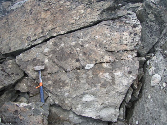
Nelson, Waldron, van Straaten, Zagorevski, and Rees


   Fig. 6. Representative photos of the Jack Formation and Snippaker clastic unit. a) Basal polymictic conglomerate, Jack Formation near Jack
   Glacier (413850 E, 6269040 N). b) Thinly bedded calcareous siltstone, fine-grained sandstone, and carbonaceous mudstone; Jack Formation
   mudstone±sandstone and siltsone facies, near Jack Glacier (413557 E, 627708 N). c) Andesite block breccia; Jack Formation middle volcaniclastic
   facies (413278 E, 6270599 N). d) Snippaker unit polymictic conglomerate. Light clasts are felsic to intermediate high-level intrusive rocks and
   silicified rocks; dark clasts are chert. Weathered-out clasts are limestone (377358 E, 6281369 N). e) Snippaker unit, thinly bedded sandstone and
   mudstone (376848 E, 6281354 N). f) Corals from partly dismembered boundstone raft, Snippaker unit (379725 E, 6279752 N).

                                                                          23
Geological Fieldwork 2017, British Columbia Ministry of Energy, Mines and Petroleum Resources, British Columbia Geological Survey Paper 2018-1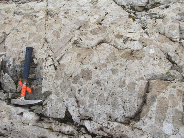
Nelson, Waldron, van Straaten, Zagorevski, and Rees

   (Fig. 4). However, this succession displays the same lithological            intermediate porphyritic intrusions, notably the Mitchell suite
   characteristics, age and stratigraphic position as the Spatsizi              at KSM (Febbo et al., 2015; Febbo, 2016) and the Lehto suite
   Formation in the upper Hazelton Group elsewhere (Gagnon et                   in the Snippaker area (Kyba and Nelson, 2015), overlap those
   al., 2012), and Treaty ridge is an informal topographic term.                of the Unuk River andesite unit (Fig. 5). We consider them
   Thus we reassign the succession to the Spatsizi Formation and                intrusive and extrusive equivalents.
   propose that the term ‘Treaty Ridge Member’ be abandoned
   (Figs. 4, 5).                                                                2.2.2. Johnny Mountain dacite unit
                                                                                  Johnny Mountain (Fig. 2) is underlain by a succession
   2.2.1. Unuk River andesite unit                                              of bedded dacite lapilli tuff and breccia (Fig. 7d) that
      We agree with the decision of Lewis et al. (2001a) to include             unconformably overlies the Stuhini Group (Kyba and Nelson,
   all lower Hazelton Group andesites previously referred to                    2015). It was previously assigned to the Brucejack Lake
   as the Unuk River Formation (Alldrick, 1987) in the Betty                    Member (Lewis et al., 2001a), and mapped, probably in error,
   Creek Formation. They include both pyroclastic (Fig. 7a) and                 as felsic and mafic Salmon River Formation (Lewis, 2013). A
   epiclastic (Fig. 7b) deposits. In general, subaerial and epiclastic          U-Pb age from this unit is ca. 194 Ma (Lewis et al., 2001b;
   deposits increase up-section in the andesitic unit, but a simple             Lewis, 2013). Given that the unit is markedly older than the
   transition is not traceable throughout the region (cf. Alldrick,             rocks at the Brucejack Lake type locality (ca. 183-188 Ma;
   1987, 1993). For example, in the section 2 km northwest of                   Lewis et al., 2001b; Lewis, 2013; Greig, 2013) and given its
   Brucejack Lake, maroon and green volcanic clast-bearing                      geographic distance from Brucejack Lake, we suggest that the
   conglomerate is at the base of the Betty Creek Formation, lying              succession forms a distinct unit and propose the name Johnny
   directly on the Jack Formation (Fig. 7c; Nelson and Kyba,                    Mountain dacite unit. It is coeval with nearby porphyry bodies
   2014). Facies distinctions can be usefully documented locally,               such as at Red Bluff and Inel (Kyba and Nelson, 2015) and
   for example on the Brucejack property where increasing                       probably represents an extrusive equivalent.
   oxidation upwards may have exerted chemical control on
   mineralization (W. Board, pers. comm., 2013; S. Flasha, pers.                2.2.3. Brucejack Lake felsic unit
   comm., 2017), but cannot be used regionally.                                    Near Brucejack Lake, the Unuk River andesite unit is overlain
      The base of the Unuk River andesite unit above the Jack                   by a felsic unit including potassium feldspar-, plagioclase-
   Formation is sharp and ranges from paraconformable to                        and hornblende-phyric flows, breccias, and bedded welded
   unconformable. It represents an abrupt transition from                       to non-welded felsic tuffs (Fig. 7e) that are intruded by a
   siliciclastic sedimentation to mixed, predominantly andesitic                flow-banded coherent plagioclase-phyric body, which grades
   pyroclastic and epiclastic accumulation. Near the Iron Cap                   upwards into flows (MacDonald, 1993). MacDonald (1993)
   deposit, a volcanic breccia lies at the base of the unit. It contains        interpreted this unit, which we refer to as the Brucejack Lake
   irregular, angular dark green andesite and lesser pinkish felsic             felsic unit (cf. ‘Member’ of Lewis, et al., 2001a; Lewis, 2013,
   clasts, overlain in part by a pillowed mafic flow (Nelson                    Fig. 4) as a flow-dome complex, representing the extrusive and
   and Kyba, 2014). North of Treaty Glacier, the basal bed is a                 high-level intrusive products of a local magmatic centre. The
   coarse, matrix-supported, polymictic volcanic-hypabyssal clast               intrusive and extrusive rocks of the unit have yielded ca. 183-
   conglomerate, overlain by monomictic andesite pyroclastic                    188 Ma U-Pb ages (Lewis et al., 2001b; Lewis, 2013; Greig,
   breccia (Nelson and Kyba, 2014). Northwest of Brucejack                      2013). Polymictic conglomerates with well-rounded cobbles to
   Lake, the polymictic basal volcanic conglomerate contains a                  boulders at the base of the unit 2 km northwest of Brucejack
   ca. 196 Ma porphyritic diorite block (J. Nelson unpublished,                 Lake (Fig. 7f) suggest that the lower contact of the unit is an
   2017) along with mostly andesite cobbles. On Snippaker                       unconformity. Felsic rocks of similar age also occur in the
   Mountain, the base of the Unuk River andesite unit cuts                      Unuk River drainage and are included in the unit.
   down through the Snippaker unit into the underlying Stuhini
   Group (Kyba and Nelson, 2015). A matrix-supported basal                      2.3. Spatsizi Formation and abandonment of ‘Treaty Ridge
   conglomerate includes both volcanic blocks derived from the                  Member’ for basal rocks in the upper Hazelton Group
   underlying Stuhini Group and intraformational sedimentary                      Examining stratigraphic relationships across Stikinia,
   clasts. A detrital zircon sample of this conglomerate contains               Gagnon et al. (2012) recognized that the Hazelton Group
   a youngest population at ca. 198 Ma, along with older Late                   consists of two parts, separated by a diachronous contact. In
   Triassic populations derived from the Stuhini Group and                      the Iskut River region, the lower part includes the Rhaetian
   comagmatic intrusions (J. Nelson unpublished, 2017). In                      to Sinemurian basal sedimentary units (Jack Formation)
   summary, U-Pb ages place the base of the Unuk River andesite                 and overlying voluminous volcanogenic strata (Betty Creek
   unit in the mid-Sinemurian (ca. 197 Ma), slightly younger than               Formation) described above. Regionally, the basal unit of
   the Jack Formation, indicating abrupt onset of voluminous                    the upper Hazelton Group is the Spatsizi Formation, defined
   andesitic volcanism. Youngest U-Pb ages, obtained from                       on the Spatsizi Plateau of north-central Stikinia (Fig. 2) as a
   minor felsic rocks in the Unuk River andesite unit, are ca.                  Pleinsbachian through Aalenian siliciclastic sequence with
   187 Ma (Cutts et al., 2015). U-Pb ages of Texas Creek suite                  minor volcanic components (Figs. 8, 9; Spatsizi Group of

                                                                           24
Geological Fieldwork 2017, British Columbia Ministry of Energy, Mines and Petroleum Resources, British Columbia Geological Survey Paper 2018-1
Nelson, Waldron, van Straaten, Zagorevski, and Rees
Fig. 7. Representative photos of the Betty Creek Formation. a) Sparse clasts in andesite lapilli tuff, Unuk River andesite unit 2 km northwest
of Brucejack Lake (426273 E, 6260107 N). b) Interbedded pebble conglomerate with volcanic clasts and tuff; Unuk River andesite unit, Treaty
Glacier (427578 E, 6272959 N). c) Tabular crowded plagioclase-phyric boulder (light-toned left foreground) in basal Unuk River andesite unit
(425715 E, 6260099 N); U-Pb zircon age ca. 197 Ma (J. Nelson, unpub. data). d) Felsic-clast breccia, Johnny Mountain dacite unit (374608 E,
6276356 N). e) Welded tuff and pyroclastic breccia, Brucejack Lake felsic unit (426343 E, 6261610 N). f) Local conglomerate at the base of the
Brucejack Lake felsic unit (426101 E, 6260852 N).
25
Geological Fieldwork 2017, British Columbia Ministry of Energy, Mines and Petroleum Resources, British Columbia Geological Survey Paper 2018-1Nelson, Waldron, van Straaten, Zagorevski, and Rees
() ( () *+ () (
*+ , - .//01 *) ,2334- 23351 *+ ,
"'1
/ +
01
/ +
01
/ +
01
!""#
2+"3"
5+1 7
68)
"9(' >(13"
: ;
1(
+('
6%
4+1()
"
' +
Nelson, Waldron, van Straaten, Zagorevski, and Rees
)" "
- -. / , +
!"%
&"
' ((&"
%
"#
!
#$!$$$$$ $
!
!
&
)"%"&*
!$
!
!
!
!
%
% %
!
!"
! +$
$ , !
! !
!
0
.
Fig. 9. Stratigraphic columns representing the Hazelton Group in the Kinaskan-Klastline-Todagin area, northern Iskut River region. Numbers
reference sources for fossil and radiometric ages. 1. Norian-Rhaetian boundary (Wotzlaw et al., 2014); 2. Rhaetian-Hettangian boundary
(Schaltegger et al., 2008); 3. Hettangian-Sinemurian boundary (Schaltegger et al., 2008); 4. Cohen et al. (2013); 5. Groat stock 205-207 Ma
(Peatfield et al., 2016); 6. Groat stock 205.1 ±0.8 (Ash et al., 1997b); 7. A. Zagorevski, unpub. Dz 10ZE-176. Main population 205.7 ±0.8 Ma;
8. Upper Triassic, Suessi zone (Late Norian-Rhaetian, collections 32781, 32767, 40482; Souther, 1972); 9. Early Jurassic (collection 32786;
Souther, 1972); contains pectinid similar to P. bodenbenderi behr similar to Weyla in Joan Member (Early Pleinsbachian; see Gagnon et al.,
2012); 10. Felsite intrusions 182-186 Ma (Ash et al., 1997a); 11. D. Alldrick and J. Nelson, unpub. data, 2017; 12. Possibly middle-Upper Jurassic
macrofossils (collection 32834, Souther, 1972); 13. Red stock 203.8 ±1.3 Ma (Ash et al., 1997b); 14. Trachyte north of Ealue Lk, 202.1 ±4.2
Ma (Ash et al., 1997b); 15. 185.6 +6.1-0.6 Ma, Freboldi zone (Lower Pleinsbachian; Palfy et. al., 2000); 16. Early Oxfordian (collection 32778,
Souther, 1972); 17. Thorkelson et al. (1995); 18. Early Pleinsbachian fossils in Cold Fish volcanics (Evenchick, 1986); 19. Toarcian fossils in Mt.
Brock volcanics (Read and Psutka, 1990); 20. Thomson et al. (1986); 21. Bathonian-Callovian fossils in Bowser Lake Group (Evenchick, 1986).
Alldrick et al., 2005b). Gagnon et al. (2012) proposed the name Lake Group, which unconformably overlies the Hazelton Group
Iskut River Formation for this succession in the Iskut River (Fig. 4).Thus, because the term ‘Salmon River Formation’ was
region and elsewhere in western Stikinia. Previously, Lewis appropriated for an entirely different succession of rocks (in
et al. (2001a) and Lewis (2013) used the term ‘Salmon River contradiction to the North American Stratigraphic Code), and
Formation’ for these rocks. However, as originally defined on because, as originally defined, the Salmon River Formation,
Mount Dilworth by Grove (1971, 1986) and Alldrick (1987), was miscorrelated, Gagnon et al. (2012) proposed that the term
the ‘Salmon River Formation’ is not a bimodal-volcanic rock ‘Salmon River Formation’ be abandoned, a recommendation
and sedimentary succession but rather comprises aNelson, Waldron, van Straaten, Zagorevski, and Rees
and ca. 179-173 Ma U-Pb zircon ages (Childe, 1996; Cutts et
al., 2015; J. Nelson and D. Alldrick, unpublished, 2017). The
base of the unit in the Treaty Glacier area is constrained by Late
Aalenian fossils at the top of the underlying Spatsizi Formation
(Nadaraju, 1993).
The Iskut River Formation is a highly variable succession in
which mafic and felsic volcanic and sedimentary units occur
in differing stratigraphic sequences, with multiple stratigraphic
repetitions in some areas. Similar to subdivisions of the Betty
Creek Formation, most of these units do not lend themselves to
formal member status. In the following we: abandon the John
Peaks Member (Lewis et al., 2001a; Lewis, 2013) and replace
it with Willow Ridge mafic unit; downgrade the Bruce Glacier
Member (Lewis et al., 2001a; Lewis, 2013) to an informal
unit; retain the ‘Eskay Rhyolite Member’ (Lewis et al., 2001a;
Lewis 2013); and introduce the Mount Madge sedimentary unit
for the Troy Ridge Member, which we abandon (Fig. 4). Fig. 10. Bruce Glacier felsic unit, welded lapilli tuff (412848 E,
6270707 N).
2.4.1. Willow Ridge mafic unit
Basalt is the most voluminous rock type in the Iskut River 2.4.3. Eskay Rhyolite Member
Formation throughout its extent. It is abundant in the Unuk The Eskay Rhyolite Member (Lewis et al., 2001a) forms
River valley (Lewis, 2013; Fig. 3), where it was called the John the immediate footwall of the Eskay deposit at the northern
Peaks Member (Lewis et al., 2001a). However, the John Peaks end of the Eskay anticline (Fig. 5) where it was rigorously
massif is underlain by an Early Jurassic pluton, which Lewis defined by mapping and core logging as a single, linear flow-
(2013) named the John Peaks pluton. Because John Peaks dome complex of coherent to brecciated flows that show
do not expose the basalts and because the same name is used peperitic contacts with the overlying argillite, which is the host
for two different rock bodies, we propose that the term ‘John for massive sulphide mineralization (Bartsch, 2001; Barrett
Peaks Member’ be abandoned. Alldrick et al. (2004b) proposed and Sherlock, 1996; Childe, 1996). Childe (1996) obtained
Willow Ridge as a type section of basalt typical of the Iskut a U-Pb zircon age of 175 ±2 Ma from the Eskay rhyolite,
River Formation. This locality, between Table Mountain and identical within error to ages in the Bruce Glacier felsic unit.
Kinaskan Lake (Figs. 2, 3), displays typical variations within Geochemistry of the rhyolite (Al/Ti>100) also distinguishes
the unit and is road accessible. We recommend the term Willow it from other felsic bodies in the area, although this does not
Ridge mafic unit for these rocks. constitute a lithostratigraphic criterion.
2.4.2. Bruce Glacier felsic unit 2.4.4. Mount Madge sedimentary unit
Non-welded to welded lapilli tuff (Fig. 10), felsic volcanic The Eskay Rhyolite Member is overlain by thinly bedded
breccia and coherent flows, and volcanic conglomerates occur black argillaceous mudstone and felsic tuff. This unit hosts
extensively around the periphery of the McTagg anticlinorium, most of the mineralization at Eskay Creek where it is referred to
where they form the local basal unit of the Iskut River as the Contact argillite (Barrett and Sherlock, 1996). Elsewhere
Formation (Fig. 3). This unit also occurs in the Eskay anticline, in the Iskut River Formation, tuff-argillite units occur as thin,
in the footwall of the Eskay deposit, and overlying Betty discontinuous lenses enclosed within volcanic rocks. They
Creek strata west of Harrymel Creek (Lewis, 2013). In the were included in the Troy Ridge Member as defined by Lewis
Bruce Glacier area, it unconformably overlies the Jack, Betty et al. (2001a) because of their similarity to siliceous strata at the
Creek and Spatsizi formations. Similar felsic rocks also occur type locality on Troy ridge. However, the rocks on Troy ridge
at higher stratigraphic levels, such as at the top of the Iskut are now assigned to the regionally extensive Quock Formation
River Formation on Treaty ridge and above pillow basalts of (see section 2.6. below). We suggest that Mount Madge (Fig. 2)
the Willow Ridge mafic unit on Pillow Basalt ridge and Table be the type locality for isolated occurrences in the Iskut River
Mountain (see below). Because of this repetition, we refer to Formation, because Lewis (2001, 2013) has documented two
these felsic rocks as the Bruce Glacier felsic unit, rather than prominent layers on its higher slopes. Other examples occur
retaining the formal ‘Member’ status used by Lewis et al. north of the McTagg anticlinorium, at the head of Treaty
(2001a). Six SHRIMP U-Pb zircon ages from the unit range Glacier, and near Granduc (Lewis, 2001, 2013).
from 178.5 ±1.8 to 173.3 ±1.8 Ma (Cutts et al., 2015). These
ages agree well with the multigrain TIMS ages presented in 2.5. Mount Dilworth Formation
Lewis (2013), and support the Middle Jurassic age of the Iskut Dacite and rhyolite form laterally continuous exposures
River Formation. on Mount Dilworth and Troy ridge in the Salmon River
28
Geological Fieldwork 2017, British Columbia Ministry of Energy, Mines and Petroleum Resources, British Columbia Geological Survey Paper 2018-1Nelson, Waldron, van Straaten, Zagorevski, and Rees
area, above the Betty Creek Formation and below the Quock legend subdivisions in Alldrick et al., 2006). In the following,
Formation (see below). They constitute the Mount Dilworth we apply Hazelton Group terminology developed above for
Formation as originally defined by Alldrick (1987). A U-Pb the Stewart-McTagg anticlinorium-Snippaker Mountain area
zircon SHRIMP age of 173.6 ±1.7 Ma from the northern ridge to previously unnamed units. We also propose new informal
of Mount Dilworth (Cutts et al., 2015) shows that these rocks names for rocks in the Iskut River Formation that do not occur
are coeval with the Bruce Glacier felsic unit of the Iskut River farther south: Kinaskan conglomerate unit, Downpour Creek
Formation. We suggest that the Mount Dilworth Formation be siliciclastic unit, and Palmiere dacite-mudstone unit.
retained as part of the upper Hazelton Group, distinguished
from felsic units in the Iskut River Formation by its tabular 3.1. Units in the lower Hazelton Group
geometry, regional extent, and lack of interfingering with mafic 3.1.1. Jack Formation(?)
units. It indicates widespread Aalenian felsic activity proximal At two localities along a southern tributary to Ball Creek,
to, but outside of, the Eskay rift. east of the Matthew Glacier (Figs. 2, 12), a siliciclastic
sedimentary-volcanic succession (unit 13 of Souther, 1972)
2.6. Quock Formation yielded Hettangian ammonites (Psiloceras canadense Frebold).
The highest unit of the Hazelton Group regionally is the These rocks overlie the Stuhini Group in the hinge zone of a
Quock Formation, which ranges from Bajocian in the Spatsizi syncline (Souther, 1972). Although lacking the characteristic
Plateau area (Fig. 9) to Callovian near Terrace (Gagnon et conglomerates, these rocks are coeval with the Jack Formation
al., 2012). It comprises 50-100 m of thinly bedded, dark grey elsewhere and, like Jack Formation equivalents, form the basal
siliceous argillite with pale felsic tuff laminae, and radiolarian unit of the Hazelton Group in this area.
chert. The dark and light striping led to the unit being informally
but unforgettably termed ‘pyjama beds’ by Howard Tipper of 3.1.2. Betty Creek Formation
the Geological Survey of Canada. It is at least in part a facies Isolated occurrences of Lower Jurassic andesites between
equivalent of the Iskut River Formation. Downpour Creek and the Little Iskut River are herein assigned
The Quock Formation forms a thin but regionally continuous to the Unuk River andesite unit. Felsic units near Downpour
layer on Mount Dilworth and Troy ridge, above the Mount Creek (Logan et al., 2000; Alldrick et al., 2005b) and Ball
Dilworth Formation and below the Bowser Lake Group. It was Creek (Alldrick et al., 2004a, b) are designated as unnamed
previously called the Troy ridge facies of the Salmon River rhyolites in the Betty Creek Formation (Fig. 12). The unit near
Formation (Anderson and Thorkelson 1990), and later the Troy Downpour Creek is Sinemurian based on a conodont collection
Ridge Member of the Salmon River Formation (Lewis et al., in overlying strata (Logan et al., 2000). The rhyolites near
2001a; Lewis, 2013). Because Troy ridge is an informal locality, Ball Creek occur in a succession containing Pleinsbachian
we favour the usage of Gagnon et al. (2012) and propose that ammonites (Souther, 1972).
these rocks be included in the Quock Formation, which forms a
thin but areally extensive layer at the top of the Hazelton Group 3.2. Units in the upper Hazelton Group
throughout Stikinia, outside of the Eskay rift. The Iskut River Formation was first defined based on
stratigraphic sections in this area (Gagnon et al., 2012). Below
3. Ball Creek-Forrest Kerr Creek-Table Mountain (central) we assign previously unnamed basaltic sequences to the
area Willow Ridge mafic unit, rhyolites to the Bruce Glacier felsic
This area extends north from the confluence of Forrest Kerr unit, and fine-grained siliceous sequences to the Mount Madge
Creek and the Iskut River and includes the Downpour Creek, sedimentary unit, as described from the southern area. The area
More Creek, and Ball Creek drainages, Table Mountain, and also contains units not seen in the southern sub-area (Fig. 12).
Willow Ridge (Fig. 2). Rocks of the Iskut River Formation Sections many hundreds of metres thick of mainly medium-
are exposed in northerly, fault-bounded graben in contact with grained siliciclastic beds near Downpour Creek and on Table
older units of the Stuhini Group and Paleozoic stratified and Mountain are assigned to the Downpour Creek siliciclastic
intrusive bodies. unit (new name). Conglomerates south of Downpour Creek
Souther (1972) mapped the area at a 1:250,000 scale, and on western Table Mountain are assigned to the Kinaskan
providing a broad bedrock framework and important age conglomerate (new name). Also not recognized in the south,
constraints from macrofossil collections (Fig. 11). Subsequent the Palmiere unit (new name) is a unique felsic volcaniclastic-
1:50,000-scale mapping was supported by macrofossil and mudstone succession that occurs on both sides of the Iskut
microfossil collections and sparse U-Pb geochronology (Read River near Palmiere Creek (Fig. 2).
et al., 1989; Logan et al., 2000). Alldrick et al. (2004a, b; 2005,
a, b; 2006) mapped from Forrest Kerr Creek to Kinaskan Lake 3.2.1. Willow Ridge mafic unit
(Fig. 2), identifying a series of geographically named sub- As is the case elsewhere in the region, basalt and pillow basalt
basins in the Eskay rift, each with a distinct stratigraphy, and are the most widespread and thickest Iskut River Formation
used unique codes for each lithotype in each sub-basin (see rock types. They form particularly thick, km-scale sections on
list of sub-basin names on Fig. 11, which correspond to major the eponymous Pillow Basalt ridge (Fig. 13a), and on Table
29
Geological Fieldwork 2017, British Columbia Ministry of Energy, Mines and Petroleum Resources, British Columbia Geological Survey Paper 2018-1Nelson, Waldron, van Straaten, Zagorevski, and Rees
()
*
)) * 1
*5 ! 5
+,-./0 2* +/3340 6 7 +
"'0
# $
! # $
/
! # $
/
!
%
&
!""#
5 6,, $
7
*8(
9 =,*
: $!
.
(,(
9
;
( 7, *9
>!(
79
: $!
)*Nelson, Waldron, van Straaten, Zagorevski, and Rees
)"
!
. $/ $
$ + $' (,-$ ,$ $ 0
!"%
&"
' ((&"
!
.
--
+
!
+
+
!
#$!$$$$$ $
!"#$
%$
& !%"#'
$
(%
!
&
)"%"&*
! $
56&7"
)!*%
+"
,-##
%#
1
-&2
%
%
*%
!
) -
3/-$ 4 ,.
! * !
$
%*"
)
% ,#-
!
!
"#
$ "%&'(
) !"#-
!
-
!/-$
0%!!
*
-
%
*")
+%
+"
!"
,
,
Fig. 12. Stratigraphic columns representing the Hazelton Group in the Forrest Kerr-Ball Creek-Table Mountain area, central Iskut region.
Numbers reference sources for fossil and radiometric ages. 1. Norian-Rhaetian boundary (Wotzlaw et al., 2014); 2. Rhaetian-Hettangian
boundary (Schaltegger et al., 2008); 3. Hettangian-Sinemurian boundary (Schaltegger et al., 2008); 4. Cohen et al. (2013); 5. Logan et al. (2000);
6. Souther (1972); 7. Evenchick et al. (2001); 8. D. Alldrick and J. Nelson, unpub. data (2017); 9. Read et al. (1989).
from diverse volcanic and intrusive sources that interfinger on Table Mountain is underlain by two basaltic units separated
a scale of less than a hundred metres (Alldrick et al., 2005b). by interbedded sandstone, siltstone and mudstone assigned to
These units are localized next to probable syn-sedimentary the Downpour Creek siliciclastic unit (Fig. 13f). Small bodies
faults, some of which were later remobilized as thrust faults of rhyolite and basalt occur within it. Rare beds of fine-grained
(Alldrick et al., 2004b, 2005b). siliceous argillite resemble the Mount Madge sedimentary
unit, but they are not separated in regional mapping. The unit
3.2.5. Downpour Creek siliciclastic unit (new name) grades laterally into a narrow zone near the western bounding
The Kinaskan conglomerate unit grades upsection and fault of coarse clastic deposits (Alldrick et al., 2004b) that we
laterally into a succession of sandstone, siltstone and mudstone assign to the Kinaskan conglomerate unit. This sequence has
that we refer to as the Downpour Creek siliciclastic unit, after yielded Late Toarcian, Early Bajocian, and Middle Bajocian
exposures near Downpour Creek (Fig. 2). The Downpour Creek macrofossil assemblages (Souther, 1972; J. Nelson and
siliciclastic unit yielded Late Toarcian to Bajocian and perhaps D. Alldrick, unpublished data, 2017).
Bathonian macrofossils (Souther, 1972; Logan et al., 2000). A
key collection from a small outlier in a synclinal keel overlying 3.2.6. Palmiere dacite-mudstone unit (new name)
lower Hazelton Group rocks yielded abundant, diverse latest The southern end and southeastern slopes of Pillow Basalt
Toarcian shelly fauna (J. Nelson and D. Alldrick, unpublished, ridge are underlain by a distinctive unit of dacite-clast volcanic
2017), which best constrains the age of the base of the Iskut breccia, dacite-clast conglomerate, arkosic sandstone, and
River Formation in this area. dark grey to black silty argillite and mudstone (Alldrick et al.,
31
Geological Fieldwork 2017, British Columbia Ministry of Energy, Mines and Petroleum Resources, British Columbia Geological Survey Paper 2018-1Nelson, Waldron, van Straaten, Zagorevski, and Rees
Fig. 13. Representative photographs of the Iskut River Formation. a) Willow Ridge mafic unit, pillow basalt, Pillow Basalt ridge (401436 E,
6298614 N). b) Bruce Glacier felsic unit, small rhyolite dome-cryptodome complex, ‘Four Corners’ area (401000 E, 6307500 N). c) Mt. Madge
sedimentary unit, laminated siliceous argillite and pale felsic tuff offset by small synsedimentary (?) faults, Pillow Basalt ridge (403000 E,
6301000 N). d) Kinaskan conglomerate unit, breccia, Sixpack ridge (405608 E, 630318 N). e) Kinaskan conglomerate unit, polymictic
conglomerate, Sixpack ridge (405424 E, 6303410 N). f) Downpour Creek clastic unit interbedded sandstone and siltstone, Table Mountain
(415000 E, 6360000 N). Monocline typical of mild deformation seen in these strata.
2005a, b). Correlative felsic breccia and argillite occur on the that imbricate them (Alldrick et al., 2005a, 2006). The Palmiere
ridge northeast of Palmiere Creek, south of the Iskut River. dacite-mudstone unit is overlain by the Bowser Lake Group.
Relationships on Pillow Basalt ridge suggest that the Palmiere On the southern end of Pillow Basalt ridge, dacite breccias
unit onlaps all older Iskut River units as well as thrust faults show incipient fragmentation textures. Large olistoliths of
32
Geological Fieldwork 2017, British Columbia Ministry of Energy, Mines and Petroleum Resources, British Columbia Geological Survey Paper 2018-1Nelson, Waldron, van Straaten, Zagorevski, and Rees
limestone are scattered within it. One has yielded Early Permian unpublished, 2017). Mapping of the Todagin Plateau near
conodonts (F129, Read et al., 1989). A macrofossil collection the Red Chris mine (Rees et al., 2015; C. Rees, unpublished,
from the unit is Middle or possibly early Late Jurassic (F141, 2017) confirmed the existence of the lower Hazelton volcanic
Read et al., 1989). unit, and at one locale documented a conglomerate at its base
The Palmiere unit appears to be the youngest unit in the Iskut above the Stuhini Group. The basal conglomerate contains
River Formation. Its suggested unconformable relationship intrusive and chert clasts (Fig. 14b). Its matrix, quartz-bearing
to other Iskut River units and structures should be further arkose with orange-weathering carbonate cement, physically
investigated, and more precise ages obtained. The Palmiere resembles the Snippaker unit. Detrital zircon peaks at 225
unit could provide constraints on episodes of transtension and and 330-355 Ma indicate regional exhumation of the Stuhini
transpression, or transfer from releasing to restraining bends, Group and its Paleozoic basement (J. Nelson and B. van
within the overall Eskay rift (Alldrick et al., 2005b). Straaten unpublished 2017). A detrital zircon sample from
basal volcanogenic sandstone on the Klastline Plateau displays
4. Kinaskan Plateau-Klastline Plateau-Todagin Plateau a major peak of ca. 205.4 Ma (A. Zagorevski, unpublished,
area 2017). This maximum depositional age likely approximates
This area was initially mapped at 1:250,000 scale by the actual age of the sandstone because the preservation of
Souther (1972). The Klastline and Todagin plateau areas were microlites suggests a proximal volcanic source. Klastline
subsequently mapped at 1:50,000 scale (Ash et al., 1996, 1997a, andesites have been interpreted as the volcanic equivalents of
b). In their study of the Stuhini, Hazelton, and Bowser Lake the ca. 206 Ma Red and Groat stocks (Friedman and Ash, 1997;
groups in the Spatsizi Plateau area, Evenchick and Thorkelson Hollis, 2011), which intrude the underlying Stuhini Group. We
(2005) overlapped the eastern limit of the present study near suggest that this be named the Tatogga intrusive suite, after
Ealue Lake and included a partial re-interpretation of mapping Tatogga Lake. The Klastline formation is intruded by numerous
by Ash et al. (1997a) on the Todagin Plateau (Evenchick and smaller undated bodies of the same suite.
Green, 2004). To constrain the northern termination of the North of Ealue Lake, a trachyte from the Klastline formation
Eskay rift, Alldrick et al. (2004a, 2006) extended mapping to yielded a ca. 202 Ma U-Pb zircon age (Ash et al., 1997b). Farther
Kinaskan Lake and southern Todagin Plateau. north and at higher elevation on the tableland, a linear body of
In the following, we replace the codes that were used for fossiliferous limestone and limestone breccia is intercalated
two new Hazelton map units recognized in the area by Ash et with the plagioclase-phyric volcanic breccias. The limestone
al. (1997a) with informal stratigraphic names, and substitute contains Late Triassic conodonts (Ash et al., 1997b). Because
units within the Iskut River Formation for unit codes used in of its age, the limestone was previously considered to be a small
Alldrick et al. (2004a, 2006; Figs. 8, 9). Uppermost Triassic (to inlier of the Stuhini Group below the volcanic pile (Ash et al.,
lowermost Jurassic?) andesites in the lower Hazelton Group are 1997a). However, limestone breccia contains volcanic matrix,
included in the Klastline formation and Lower Jurassic (partly and volcanic clasts occur within limestone (Fig. 14c; J. Nelson,
or wholly Pleinsbachian to Toarcian) bimodal volcanic and unpublished, 2014), suggesting that this limestone represents
sedimentary strata in the upper Hazelton Group are included in small bank deposits on the Klastline volcanic edifice.
the Eddontenajon formation. Also, we correlate a siliciclastic- On Klastline Plateau, small bodies of limestone and fossil
limestone unit in the upper Hazelton Group with the redefined hash with a volcaniclastic matrix occur within the andesitic
Spatsizi Formation of Gagnon et al. (2012), and an overlying succession. They were described by Ash et al. (1997a, b) as
thinly bedded siliceous unit with the Quock Formation. olistoliths. One of these occurrences is an andesite breccia
Conglomerates and sedimentary breccias, basalt and felsic containing small colonial corals, brachiopods, and gastropods,
volcanic rocks near Kinaskan Lake are considered part of the which appear to have been incorporated as individuals in a
Iskut River Formation, and named accordingly. volcanic mass flow deposit (Fig. 14d; J. Nelson, unpublished,
2014). Fossils from three collections include Paleocardita,
4.1. The lower Hazelton Group Myophoria, Pinna, and Plicatula perimbricata Gabb; assigned
4.1.1. Klastline formation (new name) a Late Norian (Suessi zone) age (E.T. Tozer in Souther, 1972).
Ash et al. (1996, 1997a, b) recognized extensive andesitic Some of these genera are also recognized in the Rhaetian of
volcaniclastic deposits and lesser flows unconformably above Europe (Hallam and Wignall, 1997). The base of the Rhaetian is
the Stuhini Group on the Klastline and Todagin plateaus now placed between ca. 205.5 Ma and its top at ca. 201.58 Ma
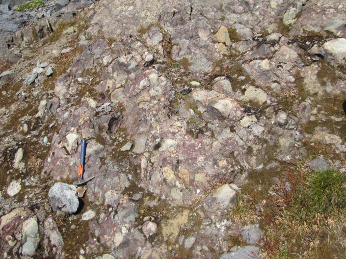
(Fig. 14a) and referred to them using informal map code (Ogg, 2012). Given its current age constraints, the Klastline
designations (units TrJavb and lJavb in Ash et al., 1997a). formation is latest Triassic (Rhaetian), with possible range into
Pending detailed study, we propose the informal name Klastline earliest Jurassic. It is coeval with the Griffith Creek volcanics
formation for these rocks. in the Spatsizi area (Fig. 9; Thorkelsen et al., 1995) and with
The andesites contain plagioclase phenocrysts accompanied the Snippaker unit to the south (Fig. 5). It is physically isolated
by either pyroxene or hornblende. They unconformably overlie from, and older than, the Betty Creek Formation, and represents
steeply dipping greywacke-argillite and pyroxene-phyric a separate, earlier episode of Hazelton andesitic volcanism.
basalt of the Stuhini Group (Ash et al., 1996, 1997a; C. Rees,
33
Geological Fieldwork 2017, British Columbia Ministry of Energy, Mines and Petroleum Resources, British Columbia Geological Survey Paper 2018-1You can also read