PLANNING MANAGEMENT PART C - Sydney Metro Airport
←
→
Page content transcription
If your browser does not render page correctly, please read the page content below
PART C

PLANNING MANAGEMENT

             C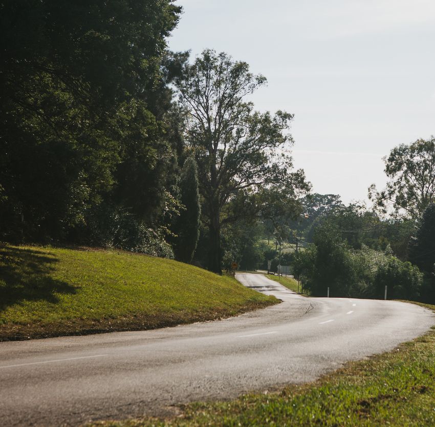
This page has been left intentionally blank.
Preliminary
                                          PreliminaryDraft
                                                      DraftMaster
                                                           MasterPlan
                                                                  Plan   Bankstown Airport
                                                                              Introduction

Ground
Transport Plan
7.1. Overview

                                                                            7
7.2. Existing ground transport network
7.3. Planning and development
7.4. Conclusion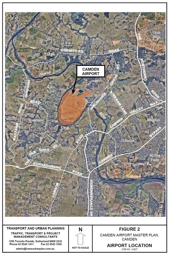
Camden Airport Preliminary
Master Plan Draft Master Plan
The Ground Transport Plan for 2015 – 2020 is based on north / south between Camden and Cobbitty Road; a length
the current landside roads network and surrounding of about 4.5kms.
access roads being used. There is no change to the
road network contemplated over the next five years. In the vicinity of the Airport, Macquarie Grove Road is a 2 lane
undivided road, rural in nature, with unsealed road shoulders
7.1 OVERVIEW and no kerbing or guttering. The road is generally 6.5 to
7.0 metres wide, is constructed in bitumen and is in good
The Ground Transport Plan for the Camden Airport 2015- condition. It is built over rolling terrain and has several curves
2035 Preliminary Draft Master Plan was completed in February and bends. It is marked with a centreline and some sections
2015. have edgelines.
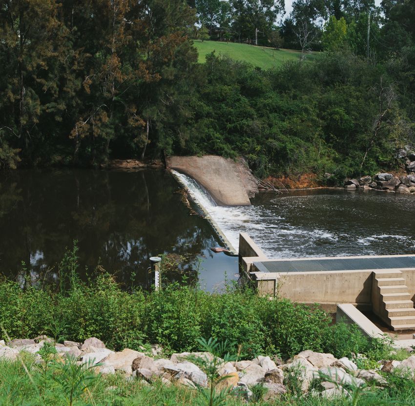
The Ground Transport Plan indicates the likely baseline trip A two lane concrete bridge over the Nepean River is located
generation capacity for the Airport. It is based on the current on Macquarie Grove Road 150 metres south of Aerodrome
needs and any appropriately approved future developments. Road. There is also a short additional climbing lane for
northbound traffic about 180 metres north of Aerodrome
Aviation activity at Camden Airport has not grown as forecast Road. Macquarie Grove Road has a 70km/h speed limit.
prior to 2010 – as the volume of fixed wing aircraft movements Development along the road (other than Camden Airport)
is currently trending downwards. As documented in Chapter consists of a mix of undeveloped rural land and residential
5, current aviation traffic forecasts are for a longer term annual properties on medium to large sized parcels of land.
average growth rate of 0.89 per cent.
Macquarie Grove Road leads to Cobbitty Road and The
In addition, largely as a result of economic conditions, much Northern Road to the north east of the Airport. The Northern
of the previously forecast Airport development has not Road is a State Road which continues north to Bringelly and
materialised. Penrith in Sydney’s outer Western suburbs. However the main
access to Camden Airport from the greater Sydney region is
This Ground Transport Plan presents the following: via Kirkham Lane, Camden Valley Way, Narellan Road and the
M31 Motorway (Hume Highway).
• the existing ground transport network; and
Kirkham Lane is a local road running south east from where
• planned ground access development for the current it meets Macquarie Grove Road, about 1.3km north east of
forecasts for air traffic movements and a proposed Aerodrome Road. It is a 2 lane undivided rural road, 2km long,
development on the Airport. linking Macquarie Grove Road and Camden Valley Way. It has
a 6 to 6.5 metre wide bitumen road surface with unsealed
shoulders and no kerbing. It is straight and has been built
7.2 EXISTING GROUND TRANSPORT
over undulating terrain. It provides access to nearby semi-
SYSTEM
rural residential properties and has a 70km/h speed limit, with
Figure 20 and 21 show the Airport’s location and the a 40km/h School Zone at its northern end. It is controlled by
surrounding region, including the road network which provides a Stop sign at Macquarie Grove Road and by a Give Way sign
surface access to the Airport. at Camden Valley Way.
Camden Airport is located approximately 1.5km north of
Camden Town Centre; 31km south west of Bankstown Camden Valley Way is a State Road running from near the
Airport; and 52km south west of the Sydney CBD. intersection of the M7 and M5 Motorways at Casula to
Camden. The section between Kirkham Lane and Narellan
Surface access to Camden Airport is entirely by road. Due to Road is about 2.2km long and is of variable width. Near
its regional, semi-rural location, there is limited public transport Kirkham Lane it is a 2 lane road with an additional right turn
service connections to the Airport. lane for traffic entering Kirkham Lane. It has a 70km/h speed
limit and is generally straight, with one bend over a crest
about 270 metres north of Kirkham Lane. The road becomes
7.2.1 External Road Network a multi-lane, divided arterial road about half way between
Kirkham Lane and Narellan Road, as it enters the Narellan
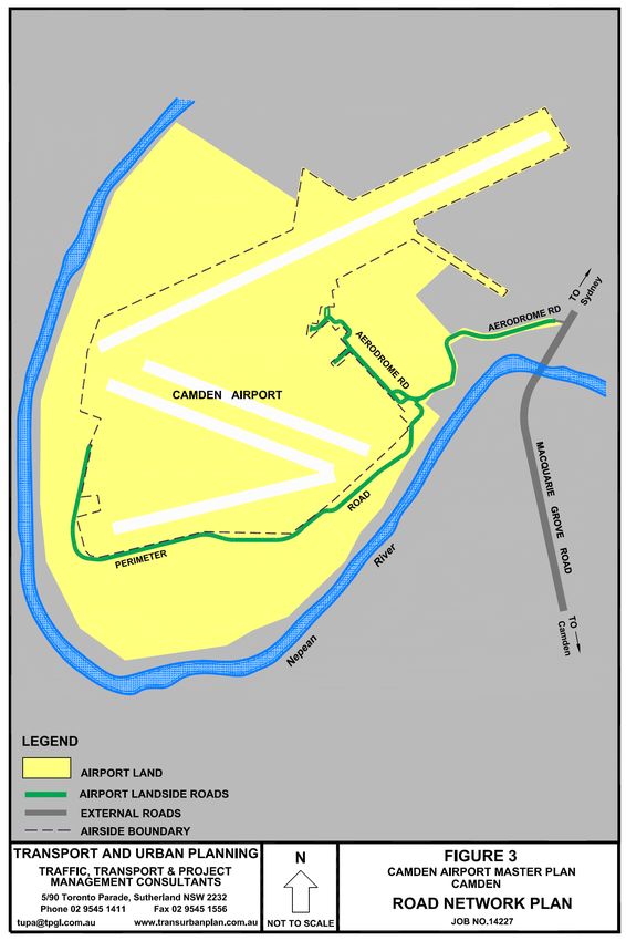
Camden Airport has one access road, Aerodrome Road,
residential and industrial areas. Camden Valley Way meets
which connects to the external road network at Macquarie
Narellan Road at a signal controlled cross intersection.
Grove Road. Macquarie Grove Road is a local road under
the care and control of Camden Council and runs generally
72 – Ground Transport Plan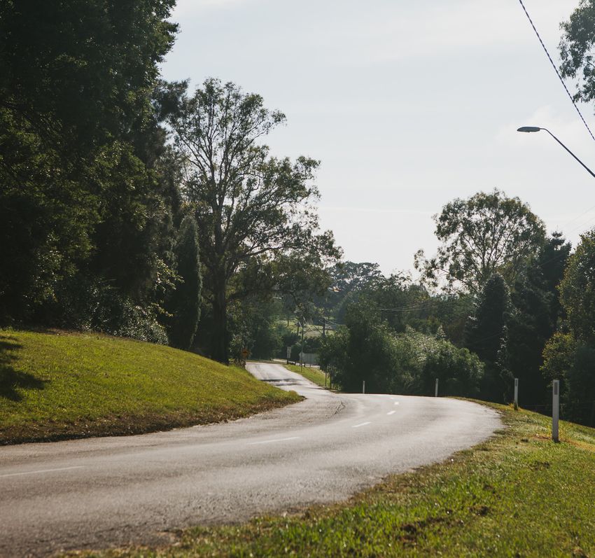
Preliminary Draft Master Plan                  Camden Airport

Figure 20 | Camden Airport in regional location context            Figure 21 | Camden Airport - location

Narellan Road is another State Road, running east west             It has 2 speed humps along this section. Several off-airport
between Camden Valley Way and the M31 Motorway (Hume               residential properties have their driveway access from this
Highway), a length of about 5km. Narellan Road is a multi-         section of Aerodrome Road.


lane, divided arterial road with an 80km/h speed limit. It
meets the M31 at a fully grade separated interchange. The          The road is signposted as a 25km/h local traffic zone. Its
M31 is a major multi-lane divided motorway with a speed limit      width varies from 5.5 metres to 6.5 metres of sealed bitumen
of 110km/h. It is part of the National Road Network, linking       in fair condition, with unsealed shoulders of variable width.
Sydney to Canberra and Melbourne.
                                                                   Upon reaching the airport landside area, the road turns to
7.2.2 Airport Roads                                                the north west and widens to facilitate parking and access to
                                                                   hangars and aviation related buildings The road terminates at
Camden Airport has one access road, Aerodrome Road, which
                                                                   a car park near the Phoenix Aero Club. The Airport Perimeter
meets Macquarie Grove Road at a T-junction. Aerodrome
                                                                   Road runs from Aerodrome Road around the southern airside
Road is controlled by a Stop sign at this intersection.
                                                                   / landside boundary to an airside access gate at the glider
                                                                   hangar area, a road length of 1.7km to the west, where the
Aerodrome Road runs a total length of 1.1km, providing
                                                                   Perimeter Road enters the airside lands.
access to both the Airport and several residential properties
which lie between Macquarie Grove Road and the Airport
                                                                   7.2.3 Alternate Transport Modes
lands.
                                                                   Camden Airport’s surface access is entirely by road, as
Figure 22 is the Airport Road Network Plan, which details the      described in section 7.
external access road and landside roads on Camden Airport.
                                                                   Currently limited public transport services to Camden Airport
The first 700 metres of Aerodrome Road runs generally east/        are available along Macquarie Grove Road (school buses
west on a winding alignment with several vertical curves. It       excepted).
is a 2 lane undivided road with a marked, broken centreline.

                                                                                                Ground Transport Plan – 73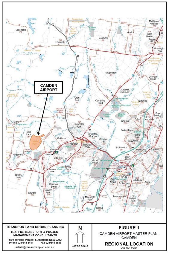
Camden Airport Preliminary
Master Plan Draft Master Plan
Figure 22 | Camden Airport – road network 7.2.5 Current Traffic Volumes
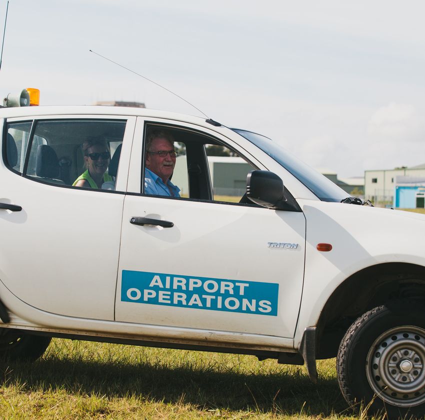
Camden Airport is predominantly used as an aviation sport
and recreation airport, and the use of all developed buildings
on the Airport is aviation related. It is understood that there
is currently up to 80 staff working on the Airport, so ground
traffic volumes are quite light and are spread across daylight
hours of all seven days of the week. Recent traffic survey data
(February 2015) for Aerodrome Road are shown in table 18.
Table 18 | Traffic survey data
Aerodrome Road, 80m west of Macquarie Grove Road
Weekday Average 7 Day Average
Vehicles
per day 477 494
The average daily traffic volume (ADT) was 494 vehicles,
which is a low volume that is easily accommodated on the
access roads and intersections.
The busiest hour was noon to 1pm, with an average of only
46 vehicles per hour.
A recent traffic survey was also carried out on Macquarie
Grove Road at the Nepean River bridge, 150 metres south
of Aerodrome Road. This location was selected because
historical ADT information is available from Roads and
Maritime Services (RMS) for this location. The historic and
recent ADT’s in table 19:
There are also no cycling or walking facilities provided along
Table 19 | ADT comparison
Macquarie Grove Road, although there is nothing preventing
cyclists using Macquarie Grove Road and Aerodrome Road
for access. In practice however, the relative remoteness of the Macquarie Grove Road, at Nepean River bridge
Airport, the ease of car access and good availability of on-site 1993 ADT 2015 ADT
parking results in no known use of any alternate transport Vehicles
modes by staff or visitors to Camden Airport. per day 2,168 4,023
7.2.4 Heavy Vehicle Access
There are no current aviation freight operations at Camden The above information indicates that traffic volumes on
Airport nor are any planned, so heavy vehicle access is limited Macquarie Grove Road have increased by 85% over the past
to low volumes of maintenance service vehicles and refuelling 22 years, which equates to an average annual compound
trucks. growth rate of 2.85%. The prime reason for this traffic growth
is understood to be the growth in residential development
There are no load limits on the external access roads or across the region.
Aerodrome Road, and the trucks that currently service
the Airport do not experience any access or on-site
manoeuvrability issues.
74 – Ground Transport Plan
Preliminary Draft Master Plan                   Camden Airport

7.2.6 Current Traffic Conditions                                   7.4 CONCLUSION
The current surveyed two way peak hour traffic flow on             Camden Airport is an aviation sport and recreation airport,
Aerodrome Road is 46 vehicles, a rate of less than one vehicle     which generates low ground traffic volumes. It is currently
per minute. This low volume of traffic means Aerodrome Road        accessed by one Airport road, Aerodrome Road, with direct
operates at a very good level of service, and no delays or         access to the external road network at Macquarie Grove
traffic congestion would occur. There is also a very large         Road. Current traffic conditions along both Aerodrome Road
spare capacity for any future growth.                              and Macquarie Grove Road are good with a significant amount
                                                                   of spare capacity. There is no justification for any upgrading of
SIDRA intersection modelling software was used to assess the       the access roads.
current operation of the intersection of Aerodrome Road and
Macquarie Grove Road. This intersection has been assessed
as operating at Level of Service A, with low delays. This level    Surface access to Camden Airport is entirely by road. There
of service is defined as “good operation’. This also indicates     are no nearby public transport services and no facilities along
that the intersection has considerable spare capacity for any      the nearby external roads for alternate transport modes
future traffic growth.                                             (bicycles, walking). The site enjoys a good level of access by
                                                                   road and there is a sufficient supply of on airport parking.
7.3 PLANNING AND DEVELOPMENT
                                                                   There are no aviation freight operations at Camden Airport,
7.3.1 Road Access Planning                                         nor are any planned.
Aerodrome Road has recently been upgraded through
installation of 2 traffic calming treatments and a marked          The only heavy vehicle usage of the Airport roads are routine
centreline. No further alterations or upgrades to Aerodrome        maintenance vehicles and refuelling tankers. The access
Road are currently planned, nor are any upgrades justified by      roads and Aerodrome Road are not load limited and there is
the low current and potential future use.                          adequate manoeuvring room on the Airport roads for these
                                                                   trucks to be able to enter and leave the site in a forward
7.3.2 Landside Development And Traffic                             direction.
Impact
                                                                   The only planned future landside development which may
The only planned development on Camden Airport that                occur within the next five years is the relocation of the Australian
may occur during the next five years is the relocation of          Aviation Museum from Bankstown Airport to Camden Airport.
the Australian Aviation Museum from Bankstown Airport to           The traffic impact of this development is expected to be
Camden Airport. The location for this museum will be in the        low, as it will maintain the current operating parameters i.e.
Aviation/Business Zone, to the north east of the control tower,    opened on Wednesday, Saturday and Sunday with visitation
and it will be accessed directly from Aerodrome Road. The          of 40-50 persons on those days and there will be a negligible
aviation museum is a low traffic generating development.           impact on the access roads to Camden Airport.
There will be very little change to average daily traffic flows
from this development, and the operation of both Aerodrome
Road and Macquarie Grove Road will be unaffected by it.

Aviation activity growth is forecast in other sections of the
2015 MP, however there will be insufficient change in daily
traffic volumes for any appreciable change in traffic conditions
on the Airport access roads.

The RMS and Camden Council currently have no known plans
to upgrade Macquarie Grove Road, Kirkham Lane, Camden
Valley Way or Narellan Road during the next five years.

Notwithstanding that no change to the road system is
expected on Camden Airport, CAL will continue to work with
the State and Local authorities or other bodies responsible for
the road network and public transport system through formal
and informal channels.

                                                                                                  Ground Transport Plan – 75
This page has been left intentionally blank.
Preliminary
                                            PreliminaryDraft
                                                        DraftMaster
                                                             MasterPlan
                                                                    Plan   Bankstown Airport
                                                                                Introduction

Socio-economic
role of Camden
Airport
8.1. Overview

                                                                            8
8.2. Operations and investment
8.3. Employment at Camden Airport
8.4. Employment in the surrounding area
8.5. Camden Airport – 2015 MP
8.6. Consistency with planning framework
8.7. Economic impacts
8.8. Social and community impacts
Camden Airport Preliminary
Master Plan Draft Master Plan
Socio-economic role of
Camden Airport
Camden Airport is the location of approximately 80 While investment in capacity is contingent on revenue and
jobs and forms part of the broader Camden economy. will be implemented on a “as needs” basis, there are specific
Implementation of the 2015 MP could potentially result items in the capital works program valued at approximately
in an additional 11-15 full time equivalent jobs. A range $1.8M for Camden Airport, including:
of other positive social and community outcomes would
also result. • Relocation of the Australian Aviation Museum from
Bankstown Airport;
8.1 OVERVIEW
• Introduction of taxiway naming protocol; and
8.1.1 Scope of Assessment
• Placement of movement area guidance signs.
The economic and community impact assessment (ECIA) of
the land use and development concept proposed in the 2015
MP examines the potential economic and community impacts 8.3 EMPLOYMENT AT CAMDEN AIRPORT
that could result from the 2015 MP, including impacts within
According to Bureau of Transport Statistics (BTS), the
the Airport itself, across the surrounding community and the
Camden Airport travel zone encompasses 57 workers. The
broader NSW and Australian economy.
main industries of employment include Education and Training
(39% of total) and Agriculture, Fishing and Forestry (18% of
8.1.2 Frame of reference
total). These results do not appear to be consistent with a
The ECIA has been prepared in accordance with the general aviation airport.
requirements of the Airports Act 1996 (the Act) – Section
71, in relation to the contents of a draft or final master Based on a recent survey (see table 20) undertaken by CAL,
plan, specifically, the sub-clauses that relate to economic, the Camden Airport accommodates between 79 and 87
employment and community impacts. workers. The majority of these workers are engaged within
aviation-related services and roles.
In undertaking the assessment, CAL has examined the 2015
MP against a frame of reference that includes Local and State
Table 20 | Camden Airport employment by industry
Government tests of socio-economic and net community
impacts, and applied an industry standard methodology to
examine impacts on the retail/centres hierarchy in the region. Industry Of Employment Number
Manufacturing 3
8.2 OPERATIONS AND INVESTMENT
Professional, scientific and technical services 38
8.2.1 Camden Airport – Operations Administrative and support services 5
Camden Airport is a leading recreational and training aviation Educational and Training 23
facility in New South Wales. More specifically, it is a general
Other services 10
aviation airport, hosting relatively small aircraft operations
in the commercial, private, sports, glider and recreational Inadequately described 8
aviation areas. Total 87
8.2.2 Investment
CAL operates a self-sustainable business. While the Airport’s 8.4 EMPLOYMENT IN THE SURROUNDING
primary purpose is accommodating general aviation services, AREA
the majority of annual income (67-75%) is generated from its
Notably, Camden Airport is distinct from adjoining uses, and as
property holdings (i.e. leasing to aviation-orientated tenants).
such, entails a different employment profile from the Camden
LGA and areas immediately surrounding it. Generally, the
While flight numbers have decreased by around 13.6% since
employment industry profile in the Camden LGA is dominated
a recent peak in FY2009, annual aviation revenues have
by population-driven industries such as retail trade (15%),
remained fairly stable and are anticipated to rise.
health care and social assistance (11%), and education
and training (10%) – accounting for approximately one-third
CAL invests in ongoing maintenance and capital investment
of all employment in the LGA. Other key industries include
of existing buildings and services, in improving existing
construction (11%), manufacturing (9%) and accommodation
facilities and in the development of new buildings to enable
and food services (7%).
future growth.
78 – Socio-economic role of Camden AirportPreliminary Draft Master Plan Camden Airport
8.5 CAMDEN AIRPORT – 2015 PDMP • Sustained growth in movements and the relocation of the
Australian Aviation Museum (outlined in the 2015 MP) will
The intention of the 2015 MP is based on CAL’s aviation result in demand for additional employment resources
vision, which is to maintain Camden Airport’s role as a leading in the long term and contribute to overall employment
recreational and training aviation facility in New South Wales. growth in the sub region – consistent with the Sydney
The 2015 MP sets out how the Airport will develop to meet Metropolitan Strategy to 2031: A Plan for Growing
aviation and non-aviation demand over the planning period. Sydney.
CAL’s commercial vision includes adding value to the non- • Accommodate diverse employment opportunities and
aviation assets of the Airport. It is CAL’s intention to enhance contribute to overall growth in the South West region.
existing businesses that will bring jobs and increase the These new opportunities will complement centres at
economic prosperity of the local community, as well as Camden, Campbelltown, Narellan and Leppington –
servicing the needs of existing airport users and the wider consistent with South West Growth Centre Planning and
community. the Camden Economic Development Strategy to 2040
(2013).
In addition to outlining the implementation of this vision, the
• Contribute to the social, cultural and recreational needs
2015 MP also outlines the approach to addressing key issues
of the community through the relocation of the Australian
arising from the vision, including infrastructure, environment,
Aviation Museum – consistent with the Camden
aircraft noise and heritage conservation.
Community Strategy to 2040 (2013) and the Camden
Local Environment Plan (2010).
There is a commitment to introducing non-aviation
stakeholders to Camden Airport. However over the past
decade, notwithstanding the growth in population in the South 8.7 ECONOMIC IMPACTS
West Growth Centre, there have been no proposals received
for developing surplus and underutilised areas of the Airport. Employment growth at the Airport is expected to mainly spur
from aviation related operations. However, projections allow
The table below presents the current land zoning mix at for a temporary increase during the construction phase of the
Camden Airport, as outlined in the 2010 Master Plan, and Australian Aviation Museum (i.e. 2015-2017), and an increase
compares it with the proposed zoning of land outlined in in the permanent workforce post-completion (beyond 2018).
the MP 2015. Overall, there has been no change in the land Overall, CAL expects future employment growth at Camden
zoning allocations in the new MP (from the existing 2010 MP). Airport to be largely organic, with most job additions being
absorbed by existing businesses and operations.
Table 21 | Camden Airport – Land Use Zones
Key potential impacts are summarised as follows:
2015 • The 2015 MP could potentially result in the creation of an
Land Use Current additional 11 to 14 full-time equivalent (FTE) at Camden
Masterplan
Aviation Zone 100.0 100.0 Airport by 2020. Greater demand from an expanding
and more affluent South West Growth Centre resident
Aviation/Business Zone 13.5 13.5 population is expected to support an increase in general
Airport Support Zone 28.5 28.5 aviation services. The projected job increases are aviation
denominated.
Environmentally Significant Zone 54.0 54.0
• The temporary workforce required to undertake the
Total 196.0 196.0 continued capital works and maintenance program at
the Airport is not significant, however, a reasonably sized
construction workforce (6-8 workers) is expected to
materialise, particularly during the construction phase of
8.6 CONSISTENCY WITH PLANNING the Aviation Airport Museum.
FRAMEWORK
• The 2015 MP could support up to an additional 71 indirect
The 2015 MP is consistent with relevant strategic planning
jobs across the economy by 2020, as well as an average
framework, outlined by the state government as well as
of 5 temporary jobs per annum over the forecast period.
Camden Council planning schemes and strategies. The 2015
MP is consistent with the surrounding planning framework, as • For each million dollars of income derived there will be
outlined following: direct flow-on benefits across the economy in regards
Socio-economic role of Camden Airport – 79Camden Airport Preliminary
Master Plan Draft Master Plan
to gross output, industry value added and household
income. The estimated direct impact as at 2020 is:
∆ Gross output: $13.8-14.4 million
∆ Value added: $9.8-10.0 million
∆ Household income: $6.1-6.5 million
Table 22 | Direct Economic Impact, Camden Airport
(FY2014-FY2020)
Ecomomic
Impact
Factor 2014 2015 2016 2017 2018 2019 2020
Output ($m) 117 - 128 - 13.1 - 13.5 13.3 13.6 - 13.8 -
13.6 13.3 13.6 - 14.1 13.9 13.9 14.4
Value 8.5 - 9.3 - 9.5 - 9.8 - 9.7 - 9.6 - 9.8 -
added ($m) 8.6 9.4 9.6 9.9 9.5 9.9 10.0
Household 5.2 - 5.7 - 5.8 - 6.0 - 5.9 - 6.0 - 6.1 -
income ($m) 5.8 6.2 6.4 6.5 6.3 6.4 6.5
Employment 80- 87- 89- 92- 91- 93- 94-
89 96 98 100 97 98 100
Source: MacroPlan Dimasi, ABS
• The prospect for non-aviation and business use
development is limited out to 2020. As such, the impact on
surrounding retail and commercial centres (e.g. Camden
and Narellan Town Centres) is anticipated to be negligible.
8.8 SOCIAL AND COMMUNITY IMPACTS
Certain social and community impacts are expected to result
from the 2015 MP. Some of the more pertinent social and
community impacts that could be expected to result are
outlined below:
• The 2015 MP will facilitate organic employment growth at
Camden Airport over the five years to 2020.
• Promotes visitation and awareness of Camden Airport’s
aviation capabilities given the introduction of the Australian
Aviation Museum (completion expected in 2018).
• As patronage of the Airport rises in the long term (as
predicted in the 2015 MP), there will be additional
employment opportunities for surrounding residents in
non-aviation related industries.
• Improves the potential for social interaction (leisure,
sports, flying clubs) and enhances community cohesion
amongst young and mature persons with an interest in
aviation.
80 – Socio-economic role of Camden AirportPreliminary
PreliminaryDraft
DraftMaster
MasterPlan
Plan Bankstown Airport
Introduction
Environmental
Management
9.1. Overview
9
9.2. Soil conditions
9.3. Surface water quality
9.4. Groundwater quality
9.5. Flora and fauna
9.6. Ground based noise
9.7. Air quality
9.8. Heritage
9.9. Resource efficiency
9.10. On-going regulation and managementCamden Airport Preliminary
Master Plan Draft Master Plan
Environmental management
CAL will continue to build on the environmental 9.3 SURFACE WATER QUALITY
management improvements on the Airport. Best practice
environmental management systems will ensure The Nepean River, a major waterway draining to the
ongoing improvement of the Airport‘s environment in Hawkesbury River, borders the eastern, southern and
relation to all relevant aspects including protection of western boundaries of Camden Airport. A number of activities
sites of environmental significance and heritage items. undertaken at the Airport have the potential to affect the water
quality of the Nepean River, including:
9.1 OVERVIEW
• spills and leaks during aircraft servicing and maintenance,
A detailed description of key environmental issues and aircraft refueling, and runoff from aircraft washing;
management measures at the Airport is presented in the Airport
Environment Strategy (AES) (see Appendix B). A summary of • spills and leaks during vehicle refueling and maintenance,
the environmental issues, which in CAL’s assessment, might and runoff from vehicle washing;
reasonably be expected to be associated with implementation
of this 2015 MP are presented below. • spills and leaks or sediment discharge during construction
and maintenance activities;
Environmental impacts arising from the implementation of • spills and leaks associated with bulk liquids storage and
the Development Concept documented in this 2015 MP will handling, and
also be determined and assessed during the Airport Lessee
Company (ALC) consent process for individual proposals, • spills occasioned by accidents during vehicle travel on
with appropriate management actions established prior Airport roads.
to approval being given by the Minister in relation to Major
Development Plans and the Airport Environment Officer (AEO) Surface water quality monitoring is undertaken in accordance
for other ALC consents. with CAL’s Water Quality Management Plan. The monitoring
results are used in conjunction with findings of tenant audits
9.2 SOIL CONDITIONS and CAL inspections to develop management actions to
reduce the discharge of pollutants to surface waters. The
Camden Airport was established between 1938 and 1939 potential impacts of construction works on water quality are
and numerous activities and processes have since been managed via the Airport’s lessee company consent process
undertaken that have been identified as potential or actual for new developments.
sources of soil contamination. The potential and actual sources
of soil contamination have been reviewed and documented by Any new developments are designed, constructed and
CAL in a Contaminated Sites Register. The contaminated sites operated in accordance with Ecologically Sustainable
are investigated and managed on a priority basis according to Development (ESD) principles for water management.
the risk each site presents to the environment.
9.4 GROUNDWATER QUALITY
Management of the contamination risk presented by current
tenants is generally undertaken through the provisions of The groundwater beneath Camden Airport is not a significant
the Airports (Environment Protection) Regulations 1997 (the resource and, based on experience, is not used for drinking
Regulations) and strict lease clauses covering environmental water supply. The groundwater yield is generally low and the
performance and development controls that are imposed groundwater is saline.
upon all tenants. CAL’s environmental auditing program will
also be used to promote operational practices that reduce soil Potential sources of groundwater pollution at the Airport are:
contamination risks.
• contaminated sites;
CAL also has procedures that allow for CAL and the AEO to
investigate soil quality at the commencement and termination • leakage from underground fuel tanks;
of tenant leases. Detailed management measures are given in
• spillage of fuels and chemicals;
Section 4.3 of the AES, including the process for environmental
site assessments, remediation and validation. • chemical use such as pesticides or herbicides, and
The environmental impacts of individual developments will be • historical activities, such as land filling.
undertaken as part of CAL’s airport lessee company consent
process. This process considers soil contamination issues as Groundwater monitoring is undertaken in proximity to fuel
required by the Regulations. depots. Groundwater monitoring results have indicated some
82 – Environmental ManagementPreliminary Draft Master Plan Camden Airport
exceedances of water quality limits listed in Schedule 2 of The major sources of ground-based noise at the Airport are:
the Airports (Environment Protection) Regulations 1997 for
hydrocarbon contaminants in the vicinity of two of the three • ground running of aircraft engines;
fuel depots on the Airport. These two depots are currently
non-operational and in the process of being permanently • aircraft servicing;
closed. Investigations are underway to determine the source
• mechanical plant and servicing equipment;
of the groundwater exceedances and the requirements to
address the issue. Ongoing groundwater monitoring and • operation of fixed audible alarm or warning systems;
management of airport operations and future developments
will be used to manage groundwater quality at the Airport. • construction activities; and
Detailed management measures are given in Section 4.2 of • motor vehicle traffic.
the AES.
CAL has a Noise Management Plan (2011) for the Airport
9.5 FLORA AND FAUNA which identified initiatives to manage noise associated with
operations at Camden Airport.
Camden Airport has been largely cleared of its original,
native vegetation except for a narrow belt of River Flat Forest CAL has adopted a number of management actions to reduce
fringing the Nepean River. River Flat Forest is classified as and monitor the potential impacts of ground-based noise
an endangered ecological community under the NSW on neighboring residents, including assigning designated
Threatened Species Act 1995 and two species of flora, aircraft run-up areas (see Section 4.4 in Appendix B) and
Eucalyptus benthamii and Pomaderris brunnea, listed as restrictions on the timing of maintenance run-ups through its
‘vulnerable’ under the Environment Protection and Biodiversity Aircraft Engine Ground Running Guidelines.
Conservation Act 1999 are known to occur within this area.
Pomaderris brunnea is also listed as an “endangered” species All developments at the Airport are required to address potential
under the Threatened Species Conservation Act 1995 (NSW), noise and vibration impacts during the development planning
and Eucalyptus benthamii is listed as a “vulnerable” species and approvals stage. CAL will continue to manage ground-
under the same Act. based noise emissions via the development assessment and
approval process, use of environmental management plans
The area in which this vegetation is located is subject to a during construction and auditing of tenants’ operations.
Registered Property Agreement entered into with the NSW Monitoring of noise sources will be undertaken in the event of
Government and has been designated an Environmentally significant concerns being identified to or by CAL.
Significant Zone that is subject to a Management Plan.
9.7 AIR QUALITY
The development proposed by the 2015 MP will not impact
upon the River Flat Forest. Development would be restricted The NSW Government’s Air Quality Management Plan,
to the operational parts of the Airport which do not contain entitled Action for Air (prepared in 1998 and updated in
significant stands of vegetation. The impacts of any vegetation 2009) identified the key areas for action to manage Sydney’s
removal required for development would be assessed during air quality over the next 25 years. Airport-related air quality
the development planning stage for each development. issues continue to be regarded as being a minor contributor
Current initiatives to manage flora and fauna at the Airport to air emissions. Emissions from ground-based operations at
would continue under the implementation of the 2015 MP. the Airport, such as fuel storage, maintenance activities and
ground-based engine running constitute only a very small
No fauna species of significance have been identified on the proportion of total Airport emissions. Monitoring undertaken
Airport. at the Airport will therefore concentrate on ensuring point
source emissions at ground level do not adversely impact
9.6 GROUND-BASED NOISE local air quality.
CAL has limited influence on aircraft noise and will continue Tenants are responsible for demonstrating that their air
to work with the Australian Government, local communities, emissions, including from point sources, chemical or fuel
aircraft operators, regulators and air navigation service storages, vehicular traffic, aircraft engine ground runs or dust
providers to help develop practical solutions to mitigate noise generated during construction activities, are compliant with
impacts on communities. the requirements of the Airports Act 1996. Compliance is
progressively reviewed by CAL and the AEO as part of the
Aircraft noise from flying operations is assessed in Section environmental audit process.
5.5.
Environmental Management – 83Camden Airport Preliminary
Master Plan Draft Master Plan
The development proposed under this 2015 MP will involve included the creation of the National Heritage List and the
construction activities which may result in minor increases in Commonwealth Heritage List. Whilst Camden Airport has
diffuse source emissions of some air pollutants, particularly not been included on either of these lists, as it is located on
associated with road vehicle movements and potential short- Commonwealth Land, EPBC Act requirements do apply.
live and localised dust generation during earthworks for
developments. The potential increases in air emissions will be The 2015 MP recognises the heritage value of the Airport and
offset to some extent by measures such as: provides for the conservation of the sites’ heritage value. The
Camden Airport Heritage Management Strategy (2005) will be
• energy efficient design of new buildings; and the basis for heritage assessment and formulation of heritage
conservation policy. Specific Heritage Impact Statements will
• use of environmental management plans to reduce be prepared for developments which involve areas containing
emissions during the construction stage of new aspects identified as having heritage significance. The Heritage
developments. Impact Statements will be undertaken in accordance wilth the
EPBC Act Significant Impact Guidelines 1.2 requirements.
CAL will continue to manage air emissions via the development
assessment and approval process, use of environmental
management plans during construction and auditing of 9.9 RESOURCE EFFICIENCY
tenants’ operations. Monitoring of point sources will be
CAL’s AES requires that any proposed developments
undertaken in the event of unidentified concerns and the
– either by CAL or by other proponents – incorporate
presence of applicable standards to evaluate performance.
resource efficiency and sustainability principles in their
design, construction and operation. New developments will
9.8 HERITAGE incorporate to the extent practicable key principles such as
The Airport has been largely cleared of its original, native energy efficiency, stormwater retention and water sensitive
vegetation except for a narrow belt of River-flat Forest urban design.
adjacent to the Nepean River. Part of this remnant vegetation
is regrowth following several years of sand mining. Some 9.10 ON-GOING REGULATION AND
undisturbed areas of River-flat Forest do occur and these MANAGEMENT
areas in particular have the potential for Aboriginal sites and
It is considered that environmental impacts arising from
artefacts to be present.
developments proposed in this 2015 MP can be managed
through the environmental assessment and approvals
Aboriginal artefacts in the form of stone flakes have been
processes under the Airports Act 1996, the Airports
identified on the Airport within the Environmentally Significant
(Environment Control) Regulations 1997 and the Airports
Zone and their location has been registered in the Aboriginal
(Building Control) Regulations 1996.
Heritage Information Management System administered by
the NSW Office of Environment and Heritage (OEH). The
Development proposals must be consistent with the current
operation and future development of the Airport will not involve
Airport Master Plan, the AES and any Major Development
disturbance of the Environmentally Significant Zone and
Plan (MDP). A proponent must submit an ALC Consent form
therefore will not have a significant impact upon indigenous
to CAL, which is then assessed for potential environmental
heritage. In the event that any more items of indigenous
impacts and the effectiveness of the proposed management
heritage significance are identified during the development
measures.
process, the items would be investigated and protected in
accordance with regulatory requirements.
Development is generally also subject to subsequent
approval by the Airport Building Controller (ABC) - depending
The Airport was established as an airfield by the Macarthur-
on the nature of the proposed development. The proponent
Onslow family in the 1930s with the original Airport hangar still
is required to notify the ABC of proposed exempt building
in use today. No other buildings that pre-date the development
activities under the Airports (Building Control) Regulations
of the Airport exist within the Airport boundary. The Airport
1996.
was used by the Royal Australian Air Force (RAAF) during
World War II and a number of the hangars used at that time
The ALC Consent may contain conditions relating to
remain on the site and have some heritage value.
environmental management of the development and, in
particular the preparation of an environmental management
In 2004, a new Commonwealth heritage management
plan for the development. The environmental management
system was introduced through the Environment Protection
plans are subject to audit and inspection by CAL and
and Biodiversity Conservation Act 1999 (EPBC Act), which
the AEO.
84 – Environmental ManagementPreliminary Draft Master Plan Camden Airport
If a development is of environmental significance, the
preparation of a Major Development Plan under the Airports
Act 1996 will be required. In general, this requirement applies
to developments such as schools, hospitals, runways,
taxiways, terminals, major road works, and developments
which exceed a cost threshold (currently $20M) or add
significantly to airport capacity, or developments of a kind
that are likely to have significant environmental or ecological
impact, or which affect an area identified as environmentally
significant in the AES, or are likely to have significant impact
on the local or regional community. The development may
not proceed until approved by the Minister and must be
referred to the Australian Minister for the Environment as part
of the assessment process. ALC Consent for developments
subject to a MDP also require the approval of CAL as well as
the approval of the ABC where non-exempt building activities
are involved.
To assist CAL in deciding whether a proposal is environmentally
significant, CAL can require a proponent to prepare an
Assessment of Environmental Effects (AEE) to be submitted
with the ALC Consent. The AEE would be required to detail
all potential impacts and all measures to be undertaken to
appropriately mitigate identified adverse impacts.
Once the ALC Consent process is complete, the proponent
submits a Building Application to the ABC. If potential impacts
of construction are considered to require environmental
management, CAL will require a Construction Environmental
Management Plan to be prepared.
CAL has established a Planning Coordination Forum with
Camden Council and the NSW Government. This Forum
meets to discuss development activities on the Airport. In
addition, CAL will continue to consult widely on development
proposals through the CACACG and the extensive
communication network already established. CAL displays all
proposals on its website.
CAL will also identify other stakeholders who may be
impacted by the proposed development and consult with
and notify these stakeholders prior to deciding whether to
grant development approval, in accordance with CAL’s ALC
consent procedures.
Environmental Management – 85This page has been left intentionally blank.
Preliminary
                                 PreliminaryDraft
                                             DraftMaster
                                                  MasterPlan
                                                         Plan   Bankstown Airport
                                                                     Introduction

Airport
Infrastructure
10.1. Overview

                                                   10
10.2. Power
10.3. Water supply
10.4. Sewerage
10.5. Telecommunications
10.6. Gas
10.7. Flooding and stormwater
Camden Airport Preliminary
Master Plan Draft Master Plan
Airport infrastructure
Utilities will be provided or upgraded on the Airport 10.3.2 Upgrade required
with current technologies in line with forecasts and as
The existing Sydney Water main does not have sufficient
developments take place.
capacity to meet anticipated demand.
10.1 OVERVIEW Any aviation or non-aviation development will require an
Camden Airport is currently serviced by a range of upgrade of CAL’s internal system to provide additional
utilities including power, water supply, sewerage and capacity based on the existing external network. CAL will also
telecommunications. These utilities service the requirements discuss with Sydney Water and Camden Council the timing
of both CAL and its users and tenants. of any proposed upgrades to the external water supply and
the ability to incorporate Camden Airport into such planning.
In line with forecasts and as various developments take place
across the Airport, utilities will be provided to some areas 10.4 SEWERAGE
for the first time, while in other areas they will need to be
10.4.1 Existing services
upgraded as required.
A pumping station exists on site that connects into 150mm
A description of the current situation and working estimates of diameter gravity main along Macquarie Grove Road. The
the upgrades required is set out in the following sections for sewerage system was replaced with a new pumping station
the following utilities: and rising main in 1995. The rising main crosses under
the Nepean River, where it connects into a rising main on
• power; Macquarie Grove Road that discharges into a Pump Station,
located on the corner of Macquarie Grove Drive and Exeter
• water supply; Street.
• sewer;
10.4.2 Upgrade required
• gas; and For any aviation or non-aviation development CAL will liaise
with Sydney Water to manage this issue.
• telecommunications.
The way in which CAL proposes to address flooding and An additional gravity sewer network may be required to
stormwater drainage issues is also assessed. service proposed development. Sufficient capacity exists in
the surrounding external Sydney Water sewer infrastructure
10.2 POWER to accommodate the increased sewer discharge.
10.2.1 Existing services 10.5 TELECOMMUNICATIONS
Energy Australia supplies electricity to Camden Airport, with 10.5.1 Existing services
the existing network consisting of an 11kVA feeder, located
in Macquarie Grove Road with a spur branching off into Telstra’s existing network extends to the corner of Macquarie
Aerodrome Road that terminates at a 200kVA substation. Grove Road and Aerodrome Road. The network includes a
This substation supplies Camden Airport. This substation is Multiplexer and spare optical fibre cable.
currently loaded to approximately160kVA.
10.5.2 Upgrade required
10.2.2 Upgrade required Sufficient capacity exists to accommodate short term growth
Any proposed developments at the Airport will require an demands for both aviation and non-aviation developments.
upgrade of the existing Airport network. There is sufficient However discussions with Telstra will be required to meet
external capacity to meet the upgrade required. longer term strategies. CAL will liaise with Telstra to manage
this issue.
10.3 WATER SUPPLY
10.6 GAS
10.3.1 Existing services
10.6.1 Existing services
The current water main at Camden Airport is approximately
30 years old. There are capacity issues with the current water Gas is currently not available to this site. The closest high
supply. Water supply is via a Sydney Water main running along capacity feeder main is located along Cawdor Road and
Macquarie Grove Road. The existing network reticulates water Camden and Sheathers Lane, Grasmere. There is also a
throughout the Airport.
88 – Airport InfrastructurePreliminary Draft Master Plan Camden Airport
secondary main along Argyle Street, Camden approximately
2.2km away from the Airport.
10.6.2 Upgrade required
Sufficient capacity exists in the surrounding external Agility
network, to accommodate any demand arising from any
aviation or non-aviation development. However sufficient
demand for gas will be required to justify the provision of gas
infrastructure. CAL will liaise with Agility to manage this issue
in the longer term.
10.7 FLOODING AND STORMWATER
10.7.1 Flood management
A considerable portion of the Airport, predominantly areas
adjacent to the Nepean River are subject to flooding. Flooding
will be considered as part of any airport lessee company
consent including reference to the Nepean Flood Study 2015
10.7.2 Airport stormwater drainage
catchments
At Camden Airport the stormwater system operates efficiently
with rainfall flowing overland via open drains and canals into
the Nepean River which is adjacent to the site.
Any aviation or non-aviation development occurring over the
planning period will take into consideration the following:
• Camden Council’s relevant DCP clauses;
• Water Sensitive Urban Design – Technical Guidelines for
Western Sydney, published by the Upper Parramatta
River Catchment Trust; and
• the Principles and Guidelines contained in the NSW
Floodplain Management Manual.
Airport Infrastructure – 89This page has been left intentionally blank.
Preliminary
                                                PreliminaryDraft
                                                            DraftMaster
                                                                 MasterPlan
                                                                        Plan   Bankstown Airport
                                                                                    Introduction

Implementation
11.1. Approach to Master Plan implementation

                                                                               11
11.2. Development concept proposals
11.3. Infrastructure provision or upgrade
11.4. Development beyond 2020
Camden Airport Preliminary
Master Plan Draft Master Plan
Implementation
The aviation and non-aviation land development 11.2.1 Eastern Aviation/Business Zone
concepts outlined in this 2015 MP represent current
Development of 13,200sq/m site for the Australian Aviation
views of development expected to be realised largely
Museum including 4,600sq/m building
as a result of movement area asset management and
property initiatives over the five year implementation
period.
11.2.2 Taxiway Naming and MAGS
As an enhanced safety measure CAL will initiate a naming
11.1 APPROACH TO MASTER PLAN protocol for all taxiways on Camden Airport. The introduction
IMPLEMENTATION of taxiway naming protocol will be supported with the
installation of MOS 139 compliant Movement Areas Guidance
This 2015 MP provides a twenty year strategic planning Signs (MAGS).
framework for the future development of Camden Airport. It
demonstrates the necessary flexibility to ensure that future 11.2.3 Annual maintenance program
aviation and property industry trends and demands are
appropriately met through the provision of infrastructure. A This is a continuous improvement program for CAL-owned
summary of the potential development proposals anticipated assets dependant upon the nature and extent of the works
to be implemented in the first five years of the twenty year being undertaken. The works are necessary to meet CAL’s
planning horizon for this 2015 MP is presented. ongoing compliance obligations in relation to:
The actual timing of development proposals will depend on • heritage (where identified);
factors including:
• National Construction Code (Building Code of Australia);
• the assessment of prevailing and forecast market • Work health and safety; and
conditions;
• Australian Standards - such as residual current devices
• the demand triggers; electrical systems.
• a business case or an asset management case; 11.3 INFRASTRUCTURE PROVISION OR
• the completion of required environmental assessment
UPGRADE
and approvals processes; and Infrastructure provision is described in Chapter 10. These
developments would be implemented on an ‘as-needed’
• the outcome of stakeholder consultation processes.
basis and subject to market demands. Infrastructure provision
Land at Camden Airport is developed by CAL, sub-lessees would comprise reticulation of electricity, water and sewer to
or third party developers under commercial development necessary sites, lead-in power, and water and sewer network
agreements. All developments must be approved by CAL upgrades and amplifications.
with building approval by the Airport Building Controller and
consent to, by CAL pursuant to the process detailed in the 11.4 DEVELOPMENT BEYOND 2020
Airport (Regulations) 1997.
The South West region of Sydney is planned to grow and with
that growth the potential for airport development remains long
Potential proposals anticipated in the period between 2015
term.
and 2020 are described below in relation to:
For the timing of developments beyond the initial five year
• aviation development concept proposals;
period of the twenty year planning period, there is less certainty
• CAL land development concept proposals; when a specific demand, business case or compliance trigger
will be reached. Further, the Airports Act 1996 requires a final
• sub-lessee or third party property development proposals, Master Plan to remain in force for five years. Consequently,
and this Master Plan will be reviewed and updated by late 2020.
• infrastructure provision or upgrades.
11.2 DEVELOPMENT CONCEPT PROPOSALS
The development proposals from those described in the 2015
MP expected to be undertaken during the period 2015 to
2020 are as follows:
92 – ImplementationYou can also read