MINUTES OF MEETING - Business Papers
←
→
Page content transcription
If your browser does not render page correctly, please read the page content below
M I N U T E S              O F        M E E T I N G

       LOCAL TRAFFIC COMM IT T EE                         MEETING

Venue       Council Chambers, Station Street, Mullumbimby
Date        Tuesday, 20 March 2018
Time        10.30am
Committee   Peter Stevens – Roads and Maritime Services
Members     Linda Makejev – Roads and Maritime Services
            Snr Constable David Brigg – Police
            Snr Constable Michael Stewart – Police
            Cr Basil Cameron
            Tamara Smith MP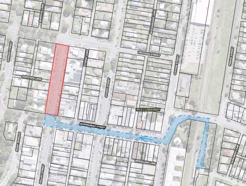
B YR O N S H I R E C O U N C I L
LOCAL TRAFFIC COMMITTEE MEETING MINUTES                                          20 MARCH 2018

REPORT OF THE LOCAL TRAFFIC COMMITTEE MEETING HELD ON TUESDAY, 20 MARCH
2018
File No: I2018/441

MEETING COMMENCED:           10:39am

PRESENT:
Councillor: Cr Basil Cameron
Roads and Maritime Services Representative: Peter Stevens
Police: Snr Constable Michael Stewart
Tamara Smith MP

Staff: Evan Elford, Tony Nash

APOLOGIES:
Linda Makejev, Snr Const David Brigg

DECLARATIONS OF INTEREST
There were no declarations of interest raised.

ADOPTION OF MINUTES FROM PREVIOUS MEETINGS

Committee Recommendation:

That the minutes of the Local Traffic Committee Meeting held on 16 January 2018 and
Extraordinary Local Traffic Committee Meeting held on 12 February 2018 be confirmed.
                                                                               (Smith/Cameron)
The recommendation was put to the vote and declared carried unanimously.

MATTERS ARISING
There were no matters arising.

OUTSTANDING ISSUES/RESOLUTIONS
None.

REGULATORY MATTERS

Report No. 6.1         Regulatory Signage - No Stopping Signage - Gulgan Road opposite
                       entrance road to Mevlana Community
File No:               I2018/43

BACKGROUND
Council is in receipt of correspondence from Melaleuca Properties requesting the installation of “No
Stopping” signage opposite their community entrance road on Gulgan Road.

Comments and/or recommendations from the LTC are sought following which Council can give
consideration to budgets and funding requirements.

The correspondence is provided below to assist members in their deliberations.

From: melaleuca [mailto:melaleucaproperties@gmail.com]

                                                                                            page 3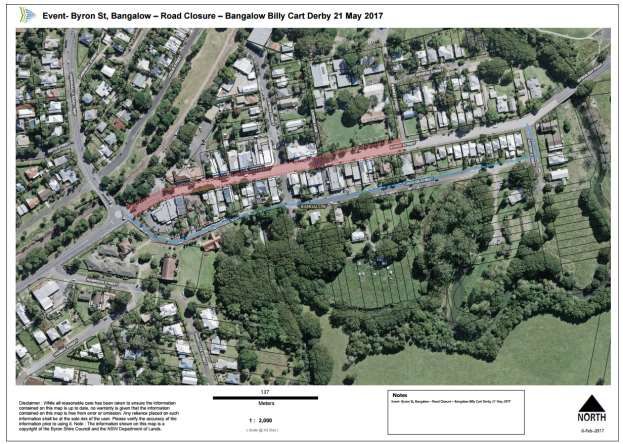
B YR O N S H I R E C O U N C I L
LOCAL TRAFFIC COMMITTEE MEETING MINUTES                                         20 MARCH 2018

Sent: Tuesday, 16 January 2018 8:50 PM
Subject: RE: NO STOPPING SIGN REQUEST

To Whom It May Concern,

Just a reminder on behalf of Melaleuca Properties (Mevlana Community) that we are requesting
from council that a ‘No Stopping’ sign be erected on Gulgan Road opposite the entry into our
private road, as sometimes cars take the opportunity to pull over and stop here (check mobiles,
check load on vehicle, etc) where a small lane has been added for the purpose of cars to
proceed when there is a turning vehicle.

If you are driving from the northern end of Gulgan Rd (from Uncle Tom’s) towards the southern
end and then wanting to turn right into our private community road, and if there are cars behind you
which are unable to use this small lane to overtake (if a vehicle has stopped there) it’s dangerous.
We’re advising you this could easily cause an accident. We would happily install a sign here but it
is on council land

Thank you for considering our request. Best Regards, From Louise, John and Saul, for the Board of
Melaleuca Properties

                                                                                             page 4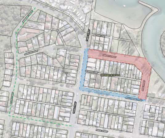
B YR O N S H I R E C O U N C I L
LOCAL TRAFFIC COMMITTEE MEETING MINUTES                                              20 MARCH 2018

Committee Comments
Install a no stopping zone at the intersection, defined by a yellow line initially. If non compliance is
an issue, install signs.

Management Comments
There were no management comments.

Committee Recommendation:

That Council:-

1.    Note the content of the correspondence from Melaleuca Properties.

2.    Install a no stopping zone at the intersection, defined by a yellow line initially and if non
      compliance is an issue, install signs.
                                                                                       (Stevens/Stewart)
The recommendation was put to the vote and declared carried unanimously.

Report No. 6.2          RMS Recommendation to extend 60km/h speed zone at Ewingsdale
                        McGettigans Lane Intersection
File No:                I2018/67

This report is for the information of the LTC and Council.

Following completion of a speed zone review on Ewingsdale Road (MR545) in the vicinity of the
McGettigans Lane intersection, RMS have determined to implement changes to increase the
extent of the 60kph speed zone.

Council are working with RMS to acquire and install signage and linemarking to implement the
changes outlined in the work instruction and Speed Zone Authorisation in relation to the Speed

                                                                                                  page 5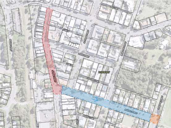
B YR O N S H I R E C O U N C I L
LOCAL TRAFFIC COMMITTEE MEETING MINUTES                                           20 MARCH 2018

Zone Review for Ewingsdale McGettigans Lane intersection, Byron Bay as outlined below.

From EEP audit and known crash history from RMS staff member, (300m extension warranted to
reduce speed on approach to the intersection)

After speaking with Greg Sciffer RMS (Land Use) it was recommended to extend the existing 60km
speed zone by a further 300m (approx) to cover the McGettigans Lane intersection which currently
sits within an 80km zone.

McGettigans Lane has been subject to subdivision development over the years which has
increasing effect on the intersection at Ewingsdale Rd.

After speaking with Council (Dominic Cavanough) about the proposed extension, Council
supported the idea.

The minimal extension distance will see an improved safety at the intersection.

Repeater signs should be installed in accordance with the speed zoning guidelines.

Installation

Council is requested to advise Roads and Maritime at least 2-3 weeks in advance of the proposed
installation date. Council will need to co-ordinate the installation with the Roads and Maritime E-
Blast.

Roads and Maritime recommends that a warning sign T1-270 is installed on both approaches to
the site advising motorists of the permanent speed zone change when the speed limit signs are
installed and remain for one week after the installation date.

Funding assistance for this project may be provided to council on request. Council is required to
provide a detailed sign installation plan detailing sign sizes and locations, including change point
and repeater signs. Signs and pavement markings should be installed in accordance with the NSW
Speed Zoning Guidelines, Section 3.3 - Signposting of Speed Zones.

For further information please contact Alan Eichmann, Senior Network and Safety Officer on 6640
1300 or email alan.eichmann@rms.nsw.gov.au who will be pleased to assist.

                                                                                            page 6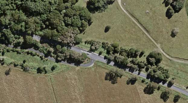
B YR O N S H I R E C O U N C I L
LOCAL TRAFFIC COMMITTEE MEETING MINUTES                               20 MARCH 2018

Fig. 1 – RMS Work Instructions to extend 60km/h speed zone at Ewingsdale Rd and
McGettigans Lane intersection

                                                                                  page 7
B YR O N S H I R E C O U N C I L
LOCAL TRAFFIC COMMITTEE MEETING MINUTES                                             20 MARCH 2018

Committee Comments
There were no committee comments.

Management Comments
There were no management comments.

Committee Recommendation:

That Council note the speed review and the extension of the 60kph speed zone being
implemented.
                                                                                (Stevens/Smith)
The recommendation was put to the vote and declared carried unanimously.

Report No. 6.3           Pocket Road - Petition - Speed Zone Review and Regulatory Signage
File No:                 I2018/204

SUMMARY

On the 29th January 2018 Council received a 16 signature petition in relation to The Pocket Road,
The Pocket and three traffic issues including a Speed Zone Review, intersection signage and
caution driveways signage.

OFFICER RECOMMENDATION

That Council approve the use of signage and line marking at the Pocket Road, Moffatts Road and
Middle Pocket Road intersections as warranted. “Caution Driveway” signs to be implemented along
the Pocket Road as warranted.

LINKAGE TO OUR COMMUNITY STRATEGIC PLAN

 Theme           Community          Services and infrastructure that sustains, connects and
                 Infrastructure     integrates our communities and environment.
 Objective       CI2                Provision of essential services
 Strategy        CI2.3              Provide roads and drainage infrastructure within the Shire
 Measures        CI2.G              Provide road, drainage and transport infrastructure within the
                                    Shire

BACKGROUND

On the 29th January 2018 Council received a 16 signature petition in regards to The Pocket Road,
The Pocket and three traffic issues including a Speed Zone Review, intersection signage and
caution driveways signage. Council resolved on the 22/02/2018 as follows:

 RES 18-035

 1.   That the petition regarding Speed Limits and Signage on The Pocket Road be noted.

 2.   That the petition be referred to the Director Infrastructure Services.

 3.   That in accordance with Council Resolution 18-035, Council receive a further report
      regarding speed limits and signage on The Pocket Road following consideration of the
      petition by the Local Traffic Committee.

                                                                                                 page 8
B YR O N S H I R E C O U N C I L
LOCAL TRAFFIC COMMITTEE MEETING MINUTES 20 MARCH 2018
The petitioners suggested that Council consider implementing 3 actions to manage the traffic
related issues identified in their document (E2018/16702) as follows:
1. That traffic travelling along this stretch of The Pocket Road be restricted to a speed of 60
km/hr
2. That clearer signs be placed along The Pocket Road to indicate the intersections with
Moffatts Road and Middle Pocket Road &
3. That Traffic should be warned about the concealed driveways by appropriate signs
Council Policy 11/006 Maximum speed limits on rural roads (W2018/754) supports a maximum
speed limit of 80 kph on all major and minor rural roads in addition to a maximum speed limit of 50
kph on all roads in village and hamlet locations within Byron Shire. Council’s supports for speed
reduction changes to 60kph as requested, is considered appropriate and in line with Council’s
policy. As a consequence, an application for speed zone review has been made with the
appropriate authority using the online portal for Safer Roads NSW
https://www.saferroadsnsw.com.au/haveyoursay.aspx.
This section of The Pocket Road, near Middle Pocket Road and Moffatts Road is relatively built up
with higher housing density than the surrounding rural landscape. The area could be classified as
semi-urban, and therefore a 60km/h speed limit would be appropriate.
The radius of the curve through this section of road is such that sight distance is minimal which
presents problems for residents entering and exiting their driveways safely, as well as for vehicle
entering and exiting Middle Pocket Road. This problem is compounded by the 80km/h speed limit
with a lack of appropriate warning signage on approach to the curve from both directions.
KEY ISSUES
1. Potential for vehicles to exceed a safe travelling speed along this narrow and tree lined
rural road.
2. Potential for vehicles to collide other road users when accessing the road via private
properties.
3. Improved directional signage at intersections for emergency services.
COUNCIL IMPLICATIONS
Budget/Financial
Estimate of $4,000 includes twenty new signs.
Asset Management
Estimate of $1400 for 20 signs at $10.00 per sign/year for an expected life of 7 years. Council
will need to maintain signage ongoing, including cleaning and replacement (if necessary).
Policy or Regulation
Delegated to council for authorisation in conjunction with:
- Prescribed traffic control devices - division 1 of Part 4 (Sections 50 to 55) of the Road
Transport (Safety and Traffic Management) Act, 1999.
o W2-206 Caution Driveways.
o W2-4 Side Road intersection
o W2-14 T-intersection curved approach
Consultation
No consultation has been carried out at this time.
page 9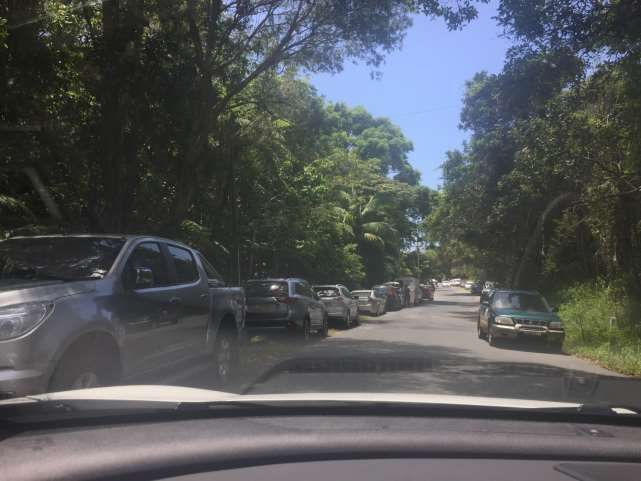
B YR O N S H I R E C O U N C I L
LOCAL TRAFFIC COMMITTEE MEETING MINUTES 20 MARCH 2018
Legal and Risk Management
Way finding signage would assist Emergency Services in locating property’s in an emergency.
Committee Comments
There were no committee comments.
Management Comments
There were no management comments.
Committee Recommendation:
That Council:
1. Approve the use of intersection signage and line marking at the Pocket Road, Moffatts Road
and Middle Pocket Road intersections as warranted.
2. Approve Caution Driveway signs to be implement along the Pocket Road as warranted.
3. Consider the allocation of $4,000 to carry out the works in the 2018/19 Capital Works
Budget.
4. Refer the application for a speed zone review to the RMS.
(Smith/Cameron)
The recommendation was put to the vote and declared carried unanimously.
Report No. 6.4 Events - Anzac Day 2018 - Road Closures in Byron, Mullumbimby,
Brunswick Heads, Bangalow
File No: I2018/374
BACKGROUND
Each year the RSL sub-branches of Byron Bay, Mullumbimby, Bangalow and Brunswick Heads
arrange their respective annual ANZAC Day street parade. All four have confirmed that little to no
change to previous years are sought. The route of each parade is shown below, noting that:
- Byron Bay : as per previous years, the Dawn Service requires closure of the Tennyson Street
and Marvell Street intersection between 4.30am and 5.30am and then again (approximately at
11am) when the parade reaches the gates to conduct the main service. Council implem ents
such measures including signed detours at the intersections prior at Marvell and Middleton
Street and at both the Kingsley Street and Carlyle Street intersections on Tennyson Street. As
for the parade, it is held under Police escort after it gathers at 10:15am off-road (Beach Hotel)
at Bay and Jonson Street, then at 10.30am proceeds south down Jonson Street, left into
Marvell Street to its end at the Memorial Gates on Tennyson Street.
- Mullumbimby : the parade will again be held under Police escort commencing this year at
10.50am from Apex Park via Burringbar Street to concluding at the cenotaph on Dalley Street
and that Council is to close Dalley Street to traffic between Burringbar Street and Tincogan
Street between 8am and 12noon with signed detours in place.
- Brunswick Heads : Police involvement with both an escort and closing of the road on Fawcett
Street between 430am and 630am. No Council involvement requested.
page 10B YR O N S H I R E C O U N C I L
LOCAL TRAFFIC COMMITTEE MEETING MINUTES 20 MARCH 2018
- Bangalow : the sub branch have confirmed the parade forms by 10.45am in front of the
Bangalow Hotel in Byron Street, and sets out by 11am east to the intersection at Station Street,
then turns left (north) to the front of the RSL Memorial Hall on Station Street for wreath laying
and ceremony through to 11.45am. Council therefore are to implement the following:
o by 10.40am through to end of event, close Station Street north of Byron Street;
o by 10.40am, close Byron Street west of Station Street and provide signed detours
south along Station Street to and via Deacon Street;
o by 10.45am close Byron Street at the east bound leg of the Granuaille Road and
Lismore Road roundabout; and
o remove the two Byron Street closures once parade has departed Byron Street.
In general it should be noted previous year’s events have not resulted in any reported safety
concern, and the road closures are typically less than one hour duration and signed detours are
implemented.
Therefore given the above, and that the local events are part of a well known and anticipated
nation wide annual tradition, the usual conditions imposed on road events (for example event
organisers to notify local residents and emergency providers, etc) is not typically applied, hence
their omissions from the recommendation now tabled.
KEY ISSUES
1. No formalised traffic control or Traffic Control Plan to RMS specifications are in place for any of
the four events.
2. Pedestrian and vehicle interaction is not managed
3. Issues have been reported about the Byron Bay Anzac Day March 2016 where live traffic was
allowed to enter the parade by volunteer traffic control under the command of the supervisor.
COUNCIL IMPLICATIONS
Budget/Financial
The event organisers have been invoiced $0.00 as they are exempt from the relevant Approval
of Road Events pursuant to s144 of the Roads Act fee as per the Fees & Charges 2016/17.
Asset Management
Not applicable.
Policy or Regulation
Speed Limit (as required) ROAD WORK (R4-212) - Delegated to council for authorisation in
conjunction with NSW Road Rules 21 and AS 1742.4 (Speed Controls) Clause 3.1.2, AS
1742.3 (Roadworks).
Consultation
A condition of the endorsement of this event is that appropriate consultation is undertaken,
including:
1. Advertising the impact of the event in the local newspaper and on the Council website.
2. Informing community and business that are directly impacted.
3. Liaising with bus and taxi operators.
4. Consulting with emergency services.
Legal and Risk Management
No formalised traffic control or Traffic Control Plan to RMS specifications are in place for any of
the four events. This may have a large insurance issue if anything goes wrong.
page 11B YR O N S H I R E C O U N C I L
LOCAL TRAFFIC COMMITTEE MEETING MINUTES 20 MARCH 2018
The Bangalow road closure directly affects RMS controlled asset - Lismore to Bangalow Road
(B62) and RMS controlled Granuaille Road. RMS Traffic Engineering Department requires to
separately approve the TMP and TCP.
Figure 1. Sketches of all four Anzac Day Marches
Location Road Closures red, green and orange. Police Escort in Blue
Byron Bay
page 12B YR O N S H I R E C O U N C I L
LOCAL TRAFFIC COMMITTEE MEETING MINUTES 20 MARCH 2018
Mullumbimby
Figure 1. Sketches of all four Anzac Day Marches
Location Road Closures red, green and orange. Police Escort in Blue
Bangalow
page 13B YR O N S H I R E C O U N C I L
LOCAL TRAFFIC COMMITTEE MEETING MINUTES 20 MARCH 2018
Brunswick
Heads
Committee Comments
There were no committee comments.
Management Comments
There were no management comments.
Committee Recommendation:
1. That Council endorse the ANZAC Day Parades for 25 April 2018 for the Return Services
League sub branches of Byron Bay, Mullumbimby, Bangalow and Brunswick Heads /
Billinudgel.
2. That the endorsement provided in Part 1 is subject to:
a) implementation of the approved Traffic Management Plan and Traffic Control Plan,
including the use of signed detours, as designed and implemented by those with
appropriate accreditation;
b) that the impact of the event be advertised via a notice in the local weekly paper a
minimum of one week prior to the operational impacts taking effect, noting it must include
the event name, specifics of any traffic impacts or road closures and times, alternative
route arrangements, event organiser, a personal contact name and a telephone number
for all event related enquiries or complaints.
page 14B YR O N S H I R E C O U N C I L
LOCAL TRAFFIC COMMITTEE MEETING MINUTES 20 MARCH 2018
c) the event be notified on Council’s webpage.
d) the event organiser:
i. undertake consultation with community and affected businesses including
adequate response/action to any raised concerns.
ii. undertake consultation with emergency services and any identified issues
addressed.
iii. holding $20m public liability insurance cover which is valid for the event.
3. That Council:
a) assists where requested with implementing the necessary temporary road closures and
detours; and
b) placing of public notice advertisements in a local weekly newspaper which is circulated
prior to the event and a copy of which is placed on Council’s web site.
(Stevens/Cameron)
The recommendation was put to the vote and declared carried unanimously.
Report No. 6.5 Events - Ballina to Byron Bay Coastal Charity Walk for Westpac
Rescue Helicopter - 27 May 2018
File No: I2018/394
The 2018 Ballina to Byron Bay Coastal Charity Walk will be held on Sunday 27 May 2018
0700 – 1700 and is the 7th consecutive year for the Charity Walk. Organisers anticipate 1,000 to
1,500 participants (capped at 2,000 attendees)
The 2018 walk starts at Missingham Park in Ballina and finishes at the Surf Life Saving Club in
Byron Bay a distance of 37km.
For 2018 the event organisers are not closing roads, they will remain open with participants
directed by Traffic Controllers.
The Ballina to Byron Bay Coastal Charity Walk, in aid of the Westpac Rescue Helicopter, to be
held Sunday, 27 May 2018 starts at Missingham Park in Ballina, and follows the coastline north to
Lennox Head, Broken Head, Tallows Beach to Cape Byron Lighthouse finishing at Dening Park in
Byron Bay, next to the Surf Life Saving Club.
Committee Comments
There were no committee comments.
Management Comments
There were no management comments.
Committee Recommendation:
1. That Council adopt the Traffic Control Plan for the Westpac Life Saver Rescue Helicopter
fundraiser, Ballina to Byron Coastal Charity Walk, to be held Sunday 27 May 2018.
page 15B YR O N S H I R E C O U N C I L
LOCAL TRAFFIC COMMITTEE MEETING MINUTES 20 MARCH 2018
2. That the approval provided in Part 1 is subject to:
a. Receipt of a satisfactory Traffic Control Plan and Traffic Management Plan.
b. implementation of the approved Traffic Management Plan and Traffic Control Plan,
including the use of signed detours, as designed and implemented by those with
appropriate accreditation.
c. that the impact of the event be advertised via a notice in the local weekly paper a
minimum of one week prior to the operational impacts taking effect, noting it must
include the event name, specifics of any traffic impacts or road closures and times,
alternative route arrangements, event organiser, a personal contact name and a
telephone number for all event related enquiries or complaints.
d. the event be notified on Council’s webpage.
e. the event organiser:
i. undertake consultation with community and affected businesses including
adequate response/action to any raised concerns.
ii. undertake consultation with emergency services and any identified issues
addressed.
iii. holding $20m public liability insurance cover which is valid for the event.
iv. paying Council’s Road Event Application Fee prior to the event.
f. the use of marshals along Marine Parade who, for the purpose of aiding and forming
participants into walking groups, are to undertake their duties in accordance with a pre-
event risk assessment and management plan, a copy of which is to be provided to
Council prior to the event
g. attainment (by the event proponent) of NPWS written acceptance of the event
3. That the approval in Part 1 is also subject to the following in regard to the use of Seven Mile
Beach Road, that is:
a. signage, which specifies the date, hours and nature of the event, be positioned at the
entrance and exit of Seven Mile Beach Road one week prior to the event;
b. on the day of the event, at 500m intervals, and facing both directions of travel, signs
advising of “ Special Event - Charity Walk Ahead” (or similar) are installed prior, and
removed after, the event occurs; and
c. a safety induction for participants advising of hazards be provided.
(Smith/Cameron)
The recommendation was put to the vote and declared carried unanimously.
page 16B YR O N S H I R E C O U N C I L
LOCAL TRAFFIC COMMITTEE MEETING MINUTES 20 MARCH 2018
Report No. 6.6 CRM 2343/2018 Broken Head Reserve Road - Regulatory Signage
File No: I2018/421
Council continues to receive requests for more parking enforcement along Broken Head Reserve
Road, Broken Head:
Those requests are typified of the latest request for action received by Council as follows:
Irrespective of the sign at the beginning of Broken Head Reserve Rd which states parking only in
marked bays, people are parking illegally.
They are blocking driveways, parking on both sides of the road and causing traffic jams.
The situation has become intolerable and extremely hazardous for pedestrians and residents
endeavouring to drive out of their driveways.
This situation needs to be urgently rectified. If Parking Attendants would book cars parked illegally
or those causing a hazard, this would raise funds for the Council and also deter parking in non-
parking bays. Another issue is speeding down Broken Head Reserve Rd. Added speed humps as
well as decreasing the speed signs to 30kmh, or less, and police booking motorists who speed,
would certainly help to make this road a much safer place.
page 17B YR O N S H I R E C O U N C I L
LOCAL TRAFFIC COMMITTEE MEETING MINUTES 20 MARCH 2018
Enforcement Officers have inspected the area and provided the following comment
Hi Team,
Please attach photos contained herein to the above CRM.
Andrew, upon inspection I concur with your view of this location as problematic, narrow and
dangerous for pedestrian traffic when busy. It is my recommendation that a hard yellow line be
painted on the road from the corner of BHR (Broken Head Road)and SMB (Seven Mile Beach Rd)
west on the southern side all the way to the last house which is #124 as a minimum control.
Alternatively, the yellow line and approximately 5x ‘No Stopping’ signs to make it obvious. This
would need to go to LTC.
Whilst the issues of speeding and speed control through the use of speed humps is a separate
matter to that of parking, Council seeks advice and recommendation from LTC regarding options
for speed control and for implementing additional “No Stopping” signage and yellow linemarking
where deemed appropriate in this location to control inappropriate parking and to improve
pedestrian safety.
Council will need to consult with NPWS and Arakwal Corporation in relation to confirmation of road
authority status.
page 18B YR O N S H I R E C O U N C I L
LOCAL TRAFFIC COMMITTEE MEETING MINUTES 20 MARCH 2018
Committee Comments
There were no committee comments
Management Comments
There were no management comments.
Committee Recommendation:
That Council prepare a plan and install “No Stopping” signs and line marking to control
inappropriate car parking and to improve pedestrian safety along Broken Head Reserve Road,
Broken Head where considered necessary.
(Stevens/Smith)
The recommendation was put to the vote and declared carried unanimously.
MATTERS FOR TRAFFIC ENGINEERING ADVICE
Report No. 7.1 Events - Byron Bay Triathlon 2018 - Traffic Management
File No: I2017/637
Council has received an event application from NXsports Community Foundation for the 2018
Byron Bay Triathlon to be held on Saturday 12 May.
page 19B YR O N S H I R E C O U N C I L
LOCAL TRAFFIC COMMITTEE MEETING MINUTES 20 MARCH 2018
This event was previously reported to the LTC in 19 September 2017 purely for consideration of
and for comments to be provided by LTC for the 2 options routes being considered by the event
organisers for the 2018 event.
19 September LTC meeting comments were supportive of the Option B route as there was less
impact on the community with less road closure.
The event organiser’s application includes relevant traffic management documents based on
Option B which is summarised below and Council is now seeking LTC recommendations.
Model B – Condensed Course
The proposed total time roads are closed is approximately 3 hours.
The southbound lane is affected for approximately 2.5 hours; and northbound lane affected for
approximately 3 hours.
The proposed model operates on three courses under a gradual closure; which will ensure that the
loading of cycles on the course remains at a reasonable level.
This model includes temporary road closures at:-
1. Browning Street
11:15am-02:30pm
2. Browning Street to Old Bangalow Road
11:30am-2:30pm
3. Old Bangalow Road to Suffolk Park BP
12:30pm-2:30pm12:30pm-2:30pm
Figure 2 – Model B: Condensed Course
page 20B YR O N S H I R E C O U N C I L
LOCAL TRAFFIC COMMITTEE MEETING MINUTES 20 MARCH 2018
Committee Comments
There were no committee comments.
Management Comments
There were no management comments.
Committee Recommendation:
That Council:-
1. Adopt the Traffic Control Plan for the 2018 Byron Bay Triathlon, subject to:
a. implementation of the approved Traffic Management Plan and Traffic Control Plan,
including the use of signed detours, as designed and implemented by those with
page 21B YR O N S H I R E C O U N C I L
LOCAL TRAFFIC COMMITTEE MEETING MINUTES 20 MARCH 2018
appropriate accreditation.
b. that the impact of the event be advertised via a notice in the local weekly paper a
minimum of one week prior to the operational impacts taking effect, noting it must
include the event name, specifics of any traffic impacts or road closures and times,
alternative route arrangements, event organiser, a personal contact name and a
telephone number for all event related enquiries or complaints.
c. the event be notified on Council’s webpage.
d. the event organiser:
i. undertake consultation with community and affected businesses including
adequate response/action to any raised concerns.
ii. undertake consultation with emergency services and any identified issues
addressed.
iii. holding $20m public liability insurance cover which is valid for the event.
iv.paying Council’s Road Event Application Fee prior to the event.
(Cameron/Stewart)
The recommendation was put to the vote and declared carried unanimously.
Report No. 7.2 Events - Bangalow Billy Cart Derby 2018- Byron St Road Closure
File No: I2018/234
SUMMARY
Council has received an event application from the Bangalow Lions Club for the 2018 Bangalow
Billy Cart Derby to be held on Sunday 20 May 2018.
From: Richard Millyard [mailto:richard@pegron.com]
Sent: Tuesday, 6 February 2018 2:31 PM
Subject: Bangalow Billycart Derby 2018
Byron Shire Council.
Traffic and Transport Planner.
The Bangalow Billycart Derby is planned for Sunday 20th May 2018, and I would like to apply on
behalf of the Bangalow Lions Club as the derby organiser this year, to close Byron Street and
divert traffic via Deacon Street in order to hold the event.
The closure of Byron Street will be from Granuaille Road to Market Street between the hours of
6.00am and 4.00pm.
Once we have gained council approval for the event I will provide Police Approval, Currency of
Insurance and any other relevant documents you may require.
Please find attached our updated TCP & TMP.
Could you please acknowledge acceptance of this request by return email.
Yours sincerely
Richard Millyard
Secretary.
page 22B YR O N S H I R E C O U N C I L
LOCAL TRAFFIC COMMITTEE MEETING MINUTES 20 MARCH 2018
Bangalow Lions Club
OFFICER RECOMMENDATION
That Council endorse the Bangalow Lions Club for the Bangalow Billy Cart Derby to be held on
Sunday 20 May 2018, that includes the temporary road closure of Byron Street, Bangalow
(between Market Street and Granuaille Road) between 6am and 4pm, subject to conditions.
LINKAGE TO OUR COMMUNITY STRATEGIC PLAN
Theme Economy A sustainable and diverse economy which provides
innovative employment and investment opportunities in
harmony with our ecological and social aims.
Objective EC1 A diverse economic base and support for local
businesses.
Strategy EC1.4 Support sporting and cultural events in Byron Shire.
Measures EC1.B Increase the sustainability of events in which Council is
involved.
BACKGROUND
The format will be the same as previous years, with traffic diverted via Deacon Street. The event
organisers have advised that they will engage Spinifex to carry out the TCP and will have
assistance from the SES in relation to traffic management.
The event organisers have provided a conforming TCP and TMP.
KEY ISSUES
1. This road closure directly affects RMS controlled asset - Lismore to Bangalow Road (B62) and
RMS controlled Granuaille Road.
2. RMS Traffic Engineering Department requires to separately approve the TMP and TCP.
3. Deacon Street is not suitable to Heavy Vehicles as a detour to the Pacific Highway.
4. Heavy Vehicles from Lismore will have to use Granuaille Road to access the Pacific Highway.
5. Increase traffic congestion as vehicle use the undesirable Deacon Street detour.
6. Deacon Street is overgrown and will require Council to trim prior to the event.
COUNCIL IMPLICATIONS
Budget/Financial
The event organisers have been invoiced $356.00 for the relevant Approval of Road Events
pursuant to s144 of the Roads Act fee as per the Fees & Charges 2017/18.
Asset Management
Not applicable.
Policy or Regulation
Speed Limit (as required) ROAD WORK (R4-212) - Delegated to council for authorisation in
conjunction with NSW Road Rules 21 and AS 1742.4 (Speed Controls) Clause 3.1.2, AS
page 23B YR O N S H I R E C O U N C I L
LOCAL TRAFFIC COMMITTEE MEETING MINUTES 20 MARCH 2018
1742.3 (Roadworks).
Consultation
A condition of the endorsement of this event is that appropriate consultation is undertaken,
including:
1. Advertising the impact of the event in the local newspaper and on the Council website.
2. Informing community and business that are directly impacted.
3. Liaising with bus and taxi operators.
4. Consulting with emergency services.
Legal and Risk Management
This road closure directly affects RMS controlled asset - Lismore to Bangalow Road (B62) and
RMS controlled Granuaille Road. RMS Traffic Engineering Department requires to separately
approve the TMP and TCP.
Figure 1. Byron Street, Bangalow road closure
Committee Comments
There were no committee comments.
Management Comments
There were no management comments.
page 24B YR O N S H I R E C O U N C I L
LOCAL TRAFFIC COMMITTEE MEETING MINUTES 20 MARCH 2018
Committee Recommendation:
1. That Council endorse the Bangalow Billy Cart Derby to be held on Sunday 20 May 2018, that
includes the temporary road closure below:
a. Byron Street, Bangalow between Ashton Street and Granuaille Road, between 6am
and 4pm on Sunday 20 May 2018.
2. That the approval provided in Part 1 is subject to:
a. implementation of the approved Traffic Management Plan and Traffic Control Plan,
including the use of signed detours, as designed and implemented by those with
appropriate accreditation;
b. that the impact of the event be advertised via a notice in the local weekly paper a
minimum of one week prior to the operational impacts taking effect, noting it must
include the event name, specifics of any traffic impacts or road closures and times,
alternative route arrangements, event organiser, a personal contact name and a
telephone number for all event related enquiries or complaints.
d.the event be notified on Council’s webpage.
e.the event organiser:
i. undertake consultation with community and affected businesses including
adequate response/action to any raised concerns.
ii. undertake consultation with emergency services and any identified issues
addressed.
iii. holding $20m public liability insurance cover which is valid for the event.
iv. paying Council’s Road Event Application Fee prior to the event.
(Cameron/Stevens)
The recommendation was put to the vote and declared carried unanimously.
Report No. 7.3 Kendall St Rail Crossing - Train and Vehicle Incidents
File No: I2018/405
Council is in receipt of correspondence from the Byron Bay Railroad Company Ltd regarding the
high number of near miss incidents between the Elements Train and vehicles at the Kendall Street
Byron Bay Railroad crossing and requesting the matter be provided to the next available LTC
meeting. The company wishes to draw the committee’s attention to these incidents and seeks
feedback and/or suggests for ways to be manage traffic to avoid these occurrences.
The content of the letter is reproduced as follows:
Byron Bay Railroad Company Ltd
P.O. Box 2150
Byron Bay NSW 2481
0418 254 624
5 March 2018
page 25B YR O N S H I R E C O U N C I L
LOCAL TRAFFIC COMMITTEE MEETING MINUTES 20 MARCH 2018
The General Manager
Byron Shire Council
MULLUMBIMBY NSW 2482
Dear Sir,
Kendall St Railway Level Crossing
Safety Interface Agreement between Byron Shire Council and Byron Bay Railroad Company
The Byron Bay Railroad Company has been operating over the Kendall Street level crossing for
more than 3 months now and is concerned at the extremely high level of non-conformance by
motorists with road traffic control signs and the number of near misses between motor vehicles and
our train.
Under Rail Safety National Law, both of our organisations have a responsibility to work together to
achieve safe outcomes.
In our view the level crossing is fully compliant with AS1742.7 and all signage meets or exceeds
the Australian Standard and our own Engineering Standards. The level crossing sighting distance
also exceed the minimum requirements of AS1742.7. We would like to record our appreciation of
Byron Shire Council’s assistance in erecting the advance warning signage and road markings to
comply with AS1742.7.
Our observations are that only 5% of motorists comply fully with the STOP signs at the level
crossing and whilst substantially more at least slow and look before proceeding over the crossing
there still is in excess of 50% of motorists who are completely ignoring the STOP signs and driving
straight across the level crossing without slowing or looking, often immediately in front of the train.
We even have multiple examples of motorists doing an ‘S’ manoeuvre around cars already
stopped at the level crossing whilst the train is closely approaching. We appreciate that it is the
NSW Police, not Byron Shire Council who are tasked with the enforcement of the road traffic rules.
We have made multiple representations to the Byron Bay Police for greater assistance in ensuring
compliance by motorists with the STOP signs.
In the first instance we would request this issue be listed for discussion on the next Traffic
Committee Meeting Agenda and we would be pleased to attend for this portion of the meeting if
that is permitted.
We would also like to work co-operatively with Council to investigate any available options that
may improve motorist compliance and the overall safety at the level crossing. Some possible
options that may be further considered include:-
More advance signage
Possibly flashing lights in advance signs similar to School Zone warning signs (these would
flash all the time between 0800 and 2200 hours and would not be activated by the train’s
approach)
Median strips to prevent motorists going around cars already stopped at the level crossing
(the narrow width of Kendall St would make this difficult)
Traffic speed humps (whilst slowing traffic, may cause other problems)
Street lighting (may help awareness of level crossing at night)
Fencing
Railway Crossing Width Marker assemblies (narrow width of Kendall St embankment would
make difficult)
Active level crossing protection (very expensive and not necessarily any more effective.
Also has significant ongoing cost.)
Tree removal and vegetation clearing (whilst improving visibility of train, it may make the
page 26B YR O N S H I R E C O U N C I L
LOCAL TRAFFIC COMMITTEE MEETING MINUTES 20 MARCH 2018
situation worse and encourage more motorists to ignore the STOP signs.)
Clearing of obstructions to existing signage or evaluating if there is a better location for
existing signage to make it more visible. (still need to comply with AS1742)
Camera monitoring and enforcement similar to Red light or speed cameras (this would
probably be new technology and may even require legislative changes)
Any other suggestions that would improve the safety at the level crossing,
We look forward to working with Council to improve this situation.
Yours sincerely,
Geoff Clark
Rail Safety Manager
Byron Bay Railroad Company
Committee Comments
The committee has concerns about the issues raised and the number of vehicles being booked for
driving through the intersection without stopping. The committee encourages Council to engage
with the issues as soon as practicable.
Management Comments
There were no management comments.
Committee Recommendation:
That Council:-
1. Note the content of the correspondence from Byron Bay Railroad Company Ltd.
2. Investigate, in conjunction with the Byron Bay Railroad Company, the issues raised.
3. Research level crossing safety and undertake risk assessment and refer back to the LTC if
required.
(Smith/Stewart)
The recommendation was put to the vote and declared carried unanimously.
Member Smith left the Chambers at 12:14 PM.
DEVELOPMENT APPLICATIONS
Report No. 8.1 DA 10.2017.510.1 - Commercial Residential Development
Cnr Jonson and Browning Sts Byron Bay
Additional comments for JRPP Submission
File No: I2018/247
The committee has previously dealt with this Development Application at 31 October 2017 and 16
January 2018 meetings, providing comments to Council’s Planners.
Subsequent to the provision of the comments of 16 January, Planners are now seeking addition
advice from LTC on the following specific matters to enable matters to be fully addressed and
reported to The Joint Regional Planning Panel (JRPP).
Planners note the previous comments from the LTC regarding the median strip along Browning
Road once the Bypass has been constructed and the recommendation for a pedestrian barrier to
prevent pedestrians spilling onto the road from the development.
page 27B YR O N S H I R E C O U N C I L
LOCAL TRAFFIC COMMITTEE MEETING MINUTES 20 MARCH 2018
However, there are two additional items relating to the DA that are particularly important to get LTC
comments regarding:
1. The applicant proposes to change Ruskin Lane into one way.
Council seeks comments from the LTC regarding to applicants proposal to change Ruskin
Lane to a one way lane. The entrance is proposed to be off Tennyson St and exit onto
Browning Street. The following issues are helpful note:
Currently it’s two way. The eastern half of Ruskin Lane was recently
upgraded to 4m wide.
The applicant has agreed, after discussions with Council’s Development
Engineer, to upgrade the western half of Ruskin Lane for its full width and for
the full frontage of the development, tying in with the recently upgraded
section of Ruskin Lane.
LTC recommended a median strip along the length of Browning St to
prevent Right Out / Right In turns and to ensure Left out / Left In turns only.
Service Trucks may still need to enter and exit Ruskin Lane via Browning St
due to the tight corner within Ruskin Lane.
2. The applicant proposes a Bin Collection Hardstand at the Browning St / Ruskin Lane
intersection. Council seeks comments from the LTC regarding the suitability of this location.
BACKGROUND
The following information has been reproduced from the 16 January report to assist members in
the deliberations.
Ruskin Lane
The site which is subject to development application 10.2017.510.1 is located at the corner of
Jonson and Browning Streets, Byron Bay, adjacent to the proposed Byron Bypass roundabout.
Ruskin Lane, which is currently a sealed two-way lane, adjoins the eastern boundary of the site.
Fig. 1 - Proposed Site Pre Byron Bay Bypass Roundabout
The application proposes to construct a mixed use development involving:
Two shops and a café at ground level, fronting Jonson Street;
page 28B YR O N S H I R E C O U N C I L
LOCAL TRAFFIC COMMITTEE MEETING MINUTES 20 MARCH 2018
A child care centre at ground level fronting Browning Street;
24 residential apartments in three levels above the shops and café;
26 serviced apartments (tourist accommodation) in three levels above the child care centre;
and
Two basement levels of car parking containing a total of 122 car parking spaces as well as
bicycle and motorcycle parking, with access off Ruskin Lane.
The Traffic Impact Study that accompanies the Development Application (see Attachment 1)
estimates total traffic generation to be approximately 349.7 – 375.7 DVT’s and 86.54 – 89.04
PHT’s and proposes the following changes to Ruskin Lane:
Widen Ruskin Lane and Browning St intersection for approximately 35m from Browning Street
to cater for two-way traffic and MRV manoeuvring (see Fig. 2);
MRV loading bay off Ruskin Lane adjacent to basement ramp;
The remainder of Ruskin Lane (approximately 135m) is proposed to be converted to one-way
with entry only from Tennyson Street;
Ruskin Lane to be restricted to left in / out movements only;
A convex mirror installed at the Ruskin Lane / Browning St intersection to provide pedestrians
with improved sight lines.
Fig. 2 - Works proposed at Ruskin Lane / Browning St intersection
West from Tennyson Intersection North from Browning St Intersection
Fig 3 – Ruskin Lane
Committee Comments
The hardstand is inappropriate due to potential impacts on traffic and pedestrians in Browning St.
An alternative location on private property should be found.
page 29B YR O N S H I R E C O U N C I L
LOCAL TRAFFIC COMMITTEE MEETING MINUTES 20 MARCH 2018
Ruskin Lane impacts:
Previous advice about median strip in Browning St will mean traffic cannot turn across
Browning St.
A change to one way east to west will impact on the access for residences on the eastern
side of Ruskin Lane, requiring vehicles to take long way around to access the road network.
If there is a change from two-way to one-way traffic along the laneway then the restriction
on the terminating traffic be controlled with islands/kerb and gutter etc.
Management Comments
There were no management comments.
Committee Recommendation:
That the committee comments be provided to Council’s Planners.
(Cameron/Stevens)
The recommendation was put to the vote and declared carried unanimously.
Report No. 8.2 Development Application 10.2013.128.3 - s96 Application to permit
paid parking during Bluesfest 2018
File No: I2018/399
Council has received a s96 Application to amend Development Consent 10.2013.128.2 for
Bluesfest at 30 Tanners Lane, Tyagarah near the Pacific Hwy Interchange. The applicant is
seeking approval to delete Condition No.59 of the consent in relation to a prohibition on charging
for parking. The condition states:
59. No Car Parking Fees
The entry for the event shall include free car parking within the site to discourage on-street
car parking on roads within the vicinity.
The purpose of the condition is to:
a) discourage parking in the surrounding road network by making parking freely available for
patrons within the Bluesfest Car Park; and
b) to enable traffic to enter the site unencumbered without the need to pay a fee at the
entrance to the site in terms of traffic management. This is of importance having regards to
the means of entrance to the site via the Pacific Hwy Off ramps with a 110 km speed
environment.
page 30B YR O N S H I R E C O U N C I L
LOCAL TRAFFIC COMMITTEE MEETING MINUTES 20 MARCH 2018
The applicants have advised of the need to charge for parking for financial reasons, whils t they
have proposed that drivers will not be charged until they have parked their vehicles and patrons
will be then approached for payment. A media campaign would advise patrons of the charges
associated with parking at BluesFest, whilst staff would be employed to monitor any queuing
issues that may arise on the Pacific Hwy, with traffic management taking priority over any
collection of car parking fees.
.
The applicant has provided details on other events that charge for parking. Concern remains as to
what impact this may have on surrounding roads should patrons look for alternative parking
arrangements, and on the safe operation of the Pacific Hwy
A copy of the Section 96 Application is attached for the Local Traffic Committees consideration.
Options for Council and the LTC are to either support the amendment or advise otherwise.
Committee Comments
The committee does not support the introduction of paid parking, on site, on the days of the event
due to the impacts on the public road network, including the Pacific Motorway.
Management Comments
There were no management comments
Committee Recommendation:
That the committee’s comments be provided to Council’s planners.
(Cameron/Stewart)
page 31B YR O N S H I R E C O U N C I L
LOCAL TRAFFIC COMMITTEE MEETING MINUTES 20 MARCH 2018
The recommendation was put to the vote and declared carried unanimously.
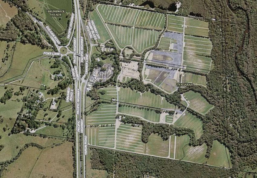
Report No. 8.3 Events - 2018 Splendour in the Grass Music Festival 20-22/7/18
File No: I2018/401
SUMMARY
Council has received a Traffic Management Plan (TMP) and Traffic Control Plan (TCP) for
Splendour in the Grass (SITG) 2018 to be held on Friday 20 July 2018 to Sunday 22 July 2018.
Figure 1. Splendour in the Grass site map
OFFICER RECOMMENDATION
That Council endorse the Traffic Management Plan and Traffic Control Plans for Splendour in the
Grass 2018 to be held on Friday 20 July 2018 to Sunday 22 July 2018, that includes the
installation and enforcement of No Camping and No Stopping signs between 6am and 6pm,
subject to conditions at:
a) Tweed Valley Way
page 32B YR O N S H I R E C O U N C I L
LOCAL TRAFFIC COMMITTEE MEETING MINUTES 20 MARCH 2018
b) Brunswick Valley Way
c) Yelgun Road
Councils Parking Enforcement be invited to assist the event in maintaining compliance of no
stopping areas within the Road Reserve.
LINKAGE TO OUR COMMUNITY STRATEGIC PLAN
Theme Economy A sustainable and diverse economy which provides
innovative employment and investment opportunities in
harmony with our ecological and social aims.
Objective EC1 A diverse economic base and support for local
businesses.
Strategy EC1.4 Support sporting and cultural events in Byron Shire.
Measures EC1.B Increase the sustainability of events in which Council is
involved.
BACKGROUND
Since 2001 Splendour in the Grass has been claimed as the biggest Winter Australian Music
festival.
2017 TMP Improvements
• Improvements made to reduce the likelihood of pedestrians making the decision to leave the
site by foot as per TMP section 8
• Pick-up/ taxi/ uber relocated to southern carpark to reduce conflict with buses. This will
improve operational efficiency of buses (again reducing likelihood of pedestrians leaving the
site by foot);
• Parking Enforcement is invited to assist with compliance of external no-stopping areas (day
& night) to reduce likelihood of patrons being "dropped" and "picked up" on the roadside;
• 2 lane departures on camping departure day which was trialled successfully at Falls recently;
• Approximately 500 parking spaces at the Mullumbimby football Field for volunteers and staff
• Detailed TCP's provided for Gate C & Gate D;
• Buses will have exclusive use of the internal bus station for more efficient operation;
• Proposed road widening internally (north of the northern carpark) to provide 3 lanes to
separate camping arrival traffic from operational traffic;
• Border Control (vehicle checking) improvements;
• The internal north/south spine road has been sealed recently to reduce dust and improve
travel times;
• Improved internal signage to direct vehicles & pedestrians efficiently;
• Channelisation & management of internal pedestrian crossings to reduce conflict with
vehicles.
The traffic management methodology for the 2018 Splendour in the Grass festival is similar to the
methodology implemented during the 2017 festival, due to the success of the latter and the
experience gained with events prior to 2017.
The 2018 Traffic Management Plan is provided a Attachment 1 (E2018/18486)
KEY ISSUES
1. Congestion caused by the event may directly affect a RMS controlled asset – Pacific Highway.
page 33B YR O N S H I R E C O U N C I L
LOCAL TRAFFIC COMMITTEE MEETING MINUTES 20 MARCH 2018
2. RMS Traffic Engineering Department are required to separately approve the TMP and TCP.
3. Pedestrian traffic along Tweed Valley Way and Brunswick Valley Way as festival goers leave
the venue on foot in the event of traffic congestion inside the site.
COUNCIL IMPLICATIONS
Budget/Financial
The event organisers are required to pay for the relevant Approval of Road Events pursuant to
s144 of the Roads Act fee as per the Fees & Charges 2017/18.
Asset Management
Not applicable.
Policy or Regulation
Speed Limit (as required) ROAD WORK (R4-212) - Delegated to council for authorisation in
conjunction with NSW Road Rules 21 and AS 1742.4 (Speed Controls) Clause 3.1.2, AS
1742.3 (Roadworks).
Consultation
A condition of the endorsement of this event is that appropriate consultation is undertaken,
including:
1. Advertising the impact of the event in the local newspaper and on the Council website.
2. Informing community and business that are directly impacted.
3. Liaising with bus and taxi operators.
4. Consulting with emergency services.
Legal and Risk Management
Congestion caused by the event may directly affect a RMS controlled asset – Pacific Highway.
RMS Traffic Engineering Department requires to separately approval of the TMP and TCP.
Committee Comments
There were no committee comments.
Management Comments
There were no management comments.
Committee Recommendation:
1. That Council approve the Splendour in the Grass 2018 TMP to be held on Friday 20 July
2018 to Sunday 22 July 2018, that includes the including the installation and enforcement of
No Camping and No Stopping signs between 6am and 6pm, subject to conditions at Tweed
Valley Way, Brunswick Valley Way and Yelgun Road
2. That the approval provided in Part 1 is subject to:
a.separate approvals by NSW Police and RMS being obtained, noting that the event is on a
state road or may impact the state road network;
b.implementation of the approved Traffic Management Plan and Traffic Control Plan,
including the use of signed detours, as designed and implemented by those with
appropriate accreditation;
page 34B YR O N S H I R E C O U N C I L
LOCAL TRAFFIC COMMITTEE MEETING MINUTES 20 MARCH 2018
c.that the impact of the event be advertised via a notice in the local weekly paper a minimum
of one week prior to the operational impacts taking effect, noting it must include the
event name, specifics of any traffic impacts or road closures and times, alternative
route arrangements, event organiser, a personal contact name and a telephone
number for all event related enquiries or complaints.
d.the event be notified on Council’s webpage.
e.the event organiser:
i. undertake consultation with community and affected businesses including
adequate response/action to any raised concerns.
ii. undertake consultation with emergency services and any identified issues
addressed.
iii. holding $20m public liability insurance cover which is valid for the event.
iv. paying Council’s Road Event Application Fee prior to the event.
v. the holding of an event debrief within a month following the festival which includes
but not limited to Council, RMS and Police;
3. Councils Parking Enforcement be invited to assist the event in compliance of no stopping
areas within the Road Reserve.
(Cameron/Stevens)
The recommendation was put to the vote and declared carried unanimously.
There being no further business the meeting concluded at 12:49pm.
page 35You can also read