ERF 25543 SAWMILL VILLAGE - TRANSPORT IMPACT ASSESSMENT GEORGE, WESTERN CAPE JANUARY 2020 - HILLAND ENVIRONMENTAL
←
→
Page content transcription
If your browser does not render page correctly, please read the page content below
Transport Impact Assessment
                                         Erf 25543 Sawmill Village

                                            George, Western Cape
                                                    January 2020

5th Floor

Imperial Terraces

Carl Cronje Drive

Tyger Waterfront

Bellville, 7530

(021) 914 6211 (T)

e-mail: mail@itsglobal.co.za
SUMMARY SHEET

Report           Transport Impact Assessment
Type

Title            Erf 25543 Sawmill Village

Location         George, Western Cape

Client           Reigate Development Projects (Pty) Ltd

Reference        ITS 3583.2
Number

Project          Christoff Krogscheepers
Team
                 Amelia Daniels

                 Carina Dippenaar

Contact          Tel: 021 914 6211
Details

Date             January 2020

Report           Draft
Status

File Name        C:\AmeliaITS\3583.2_TIA Sawmill Village Update\Report\3583.2_Erf 25543 Sawmill Village TIA
                 Report_AD_2020-01-17.docx

This transport study was prepared by a suitably qualified and registered professional traffic engineer. Details of
any of the calculations on which the results in this report are based will be made available on request.

INNOVATIVE TRANSPORT SOLUTIONS (PTY) LTD                                                                    Page i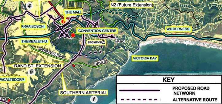
January 2020
Erf 25543 Sawmill Village                                                                                                            ITS 3583.2

TABLE OF CONTENTS

1     Purpose of Study................................................................................................................. 1

2     Locality ................................................................................................................................ 1

3     Land Use ............................................................................................................................. 1

4     Existing Roadways .............................................................................................................. 1

5     Future Roadways ................................................................................................................ 1

6     Analyses Hours ................................................................................................................... 3

7     Scenarios Analysed ............................................................................................................. 3

8     Study Intersections (existing control)................................................................................. 3

9     Existing Intersection Operations ........................................................................................ 3

10 Approved Developments/ Latent Rights ............................................................................ 4

11 Future Background Traffic Conditions ................................................................................ 5

12 Site Access .......................................................................................................................... 5

13 Trip Generation Rates and Development Trips .................................................................. 6

14 Trip Distribution .................................................................................................................. 6

15 2025 Total Traffic Conditions ............................................................................................. 6

16 Public Transport and Non-Motorised Transport ................................................................ 6

17 Parking ................................................................................................................................ 8

18 Conclusion & Recommendations ....................................................................................... 8

REFERENCES ............................................................................................................................. 10

INNOVATIVE TRANSPORT SOLUTIONS (PTY) LTD                                                                                                 Page ii
January 2020
Erf 25543 Sawmill Village                                ITS 3583.2

Annexures
Appendix A:          Figures
Appendix B:          Tables

Abbreviations
COTO            Committee of Transport Officials
Ha              Hectare
HCM             Highway Capacity Manual
LOS             Level of Service
NMT             Non-motorised Transport
SATGR           South African Trip Generation Rates
SQM             Square Meters (m2)
TIA             Transport Impact Assessment
V/C             Volume to Capacity Ratio
WCG             Western Cape Government

INNOVATIVE TRANSPORT SOLUTIONS (PTY) LTD                    Page iii
January 2020
Erf 25543 Sawmill Village ITS 3583.2
Transport Impact Assessment
1 Purpose of Study This report assesses the expected transport related impact of the proposed Erf 25543
Sawmill Village Development in George, Western Cape. This study summarises the
impact of the land use rights on the existing road network as well as the existing
transportation conditions within the site vicinity and provides an assessment of the
transportation impacts of the proposed development on the surrounding
transportation system.
2 Locality The proposed development will be located on Erf 25543, George.
The proposed development is situated to the north of the N2 off-ramp intersection
with Knysna Street, west of Welgelegen Estate and south of the Modderrug River.
The proposed new alignment of the N2 is situated to the south of the proposed
development. Refer to Annexure A, Figure 1 for the locality of the development.
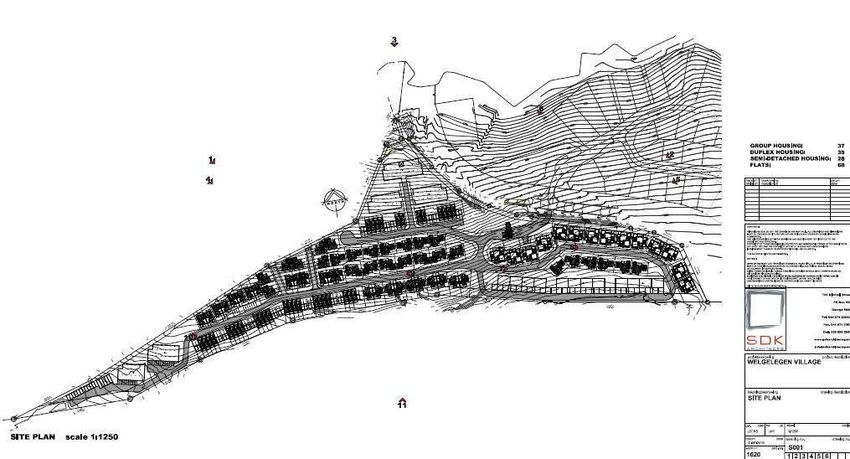
3 Land Use The proposed land use is residential, as listed below:
37 Group Housing units
35 Duplex units
28 Semi-detached Housing units
68 Flats
Refer to Annexure A, Figure 2 for the site development plan.
The analysis in the TIA is based on the development fully constructed by the year
2025.
4 Existing Roadways The following roads are located in close vicinity of the development.
N2: a Class 1 highway with two lanes per direction and posted speed of
100/80 km/h. No parking is allowed along this road and there is a median
and street lighting in both directions.
Knysna Rd: a Class 2 primary arterial with two lanes per direction and
posted speed varying between 60 km/h and 80 km/h. No parking is
available along this median divided road with street lighting in both
directions. The road provides access to the N2 towards Cape Town with on-
and off-ramps to the southwest of the proposed development.
Welgelegen Road: Class 3 road with a single lane per direction, a one
metre shoulder and a posted speed of 60 km/h. No parking is provided
along the road and there are sidewalks present for pedestrians in both
directions. Street lighting is provided.
5 Future Roadways A significant amount of planning has gone into the road network within the vicinity
of the proposed development and this is documented in several studies of which
the most noteworthy are:
George Roads Master Plan
Kraaibosch Roads Master Plan
Planning as part of the transport impact assessments done in the area.
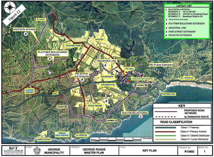
An extract of the George Roads Master plan is provided in the figure below. Refer
also to the George Roads Master Plan in Figure 10, Annexure A.
INNOVATIVE TRANSPORT SOLUTIONS (PTY) LTD Page 1January 2020
Erf 25543 Sawmill Village ITS 3583.2
Figure 1: Extract from George Roads Master Plan
The relevant long term planning of roads in the area based on the George Roads
Master Plan are the following:
The extension of the N2 to the west across the existing Sawmill, past the
Welgelegen Estate. The timeframe for this future extension is not clear.
All the planning for the Welgelegen Estate and proposed development
had to take the future alignment into account.
Welgelegen Road linking Welgelegen Estate and the areas around the
Sawmill with the N2 at the roundabout at Rademachers.
The extension of and/or link between the Welgelegen Road and the
Victoria Bay Access Road, crossing the N2.
A new interchange to the west of the current Knysna Road I/C for the
southern extension of Park Road across the N2 into the proposed Destiny
Africa development and also linking to Park Road to the north.
The extension of Park Road to the N2 to link to the new proposed
interchange.
The extension of the Servitude Road to the west to link across the rail line
and the valley to Sandkraal Road in the west.
A Southern Arterial which will intersect the current N2 at the
Rademachers Roundabout and run across the proposed Destiny Africa
land to link up with Sandkraal Road in Thembalethu and to continue all
the way to the west to link to Pacaltsdorp. This will provide a parallel
route to the south of the N2.
New roads have to be developed in the Kraaibosch area as part of the Kraaibosch
Roads Master Plan, refer to Figure 11, Annexure A. These roads include the
following important links:
The extension of the Northern Access Road of Kraaibosch Estate from
Knysna Road opposite the Mall Access Road. This road will link to the
proposed Kraaibosch Development and will eventually intersect with the
Saasveld Road north of Glenwood.
The extension of Welgelegen Road to the north and towards Kraaibosch
INNOVATIVE TRANSPORT SOLUTIONS (PTY) LTD Page 2January 2020
Erf 25543 Sawmill Village ITS 3583.2
Estate via a bridge across the Modderrug River to provide links to the
residential developments of Groenkloof and Glenwood.
The extension of the southern access road of Kraaibosch Estate to link the
extended Welgelegen Road and Groenkloof Avenue to the north.
As part of the various TIA’s which were done for the different developments the
long-term road planning was considered in detail. The planned and actual roll-out of
the roads network was in part effected by using the Municipalities Development
Contribution (DC) model to fund the construction of the major road links.
6 Analyses Hours The traffic analyses for the TIA were based on the weekday AM and PM peak hours.
The following peak hours are representative of the study area:
Weekday AM peak hour: 07:00 to 08:00
Weekday PM peak hour: 16:00 to 17:00
7 Scenarios The transport impact of the proposed development was analysed for the following
Analysed scenarios:
1. 2020 Existing conditions
2. 2025 Background traffic + Latent right traffic
3. 2025 Total traffic conditions (Background traffic conditions + Latent Right +
Development trips)
The traffic growth assumptions used to analyse future scenarios are discussed in
Section 11.
8 Study The following intersections are included in the study:
Intersections Intersection 1: Knysna Road / Welgelegen Road
(existing control) Intersection 2: Knysna Road / N2 On-ramp
Intersection 3: Knysna Road / N2 Off-ramp
Intersection 4: Knysna Road / Mall Access Road
Intersection 5: Knysna Road / Servitude Road
Intersection 6: Welgelegen Road/ Access to Development and Welgelegen
Estate
The existing geometry and control of the intersections included in the study can be
seen in Annexure A, Figure 3.
9 Existing Traffic counts conducted to the end of 2018 were used. These counts were verified
Intersection and revised according to CTO data from April – October 2019 from CTO stations
Operations situated in or near the study area.
All the intersection operation analyses were performed in accordance with the
procedures stated in the 2000 Highway Capacity Manual (HCM). The intersections in
the study area were analysed to determine the level of service (LOS), delay per
vehicle (in seconds) and volume per capacity (V/C) for each intersection in the peak
hour. Refer to Annexure A, Figure 4A and Figure 4B as well as Annexure B, Table 2
and Table 3 for the weekday AM and PM peak hour traffic operations for the
existing traffic conditions.
Based on the existing conditions analysis it is evident that all the intersections are
operating acceptably during both the typical weekday peak hours, i.e. a.m. and p.m.
peak hours. There are no improvements required to mitigate any of existing
operational issues at any of the study intersections.
INNOVATIVE TRANSPORT SOLUTIONS (PTY) LTD Page 3January 2020
Erf 25543 Sawmill Village ITS 3583.2
ITS Engineers was involved in many previous studies in the area, one of these being
the Eden Meander Development. As part of the Eden Meander TIA (ITS, 2012. Study
is available on request) it was pointed out that improvements are required to
accommodate what was termed the Phase 3 traffic of the Eden Meander
Development. One specific improvement was identified at the intersection of
Knysna Road/Mall Road and the issue that was identified is the capacity constraint
for the right turning traffic coming out of the mall and turning right towards the N2.
It was identified that the current through and right turn lane should be changed to a
shared through and right turn lane with a dedicated right turn lane. This will in fact
result in two right turn lanes, since the through traffic towards the Kraaibosch
Manor area are relatively low. The intersection layout is such that the identified
improvement is not simply a re-marking of the approach, but involved some
geometric work to change the median islands to assist with the movement. This
work is currently in process.
10 Approved To correctly evaluate the proposed development in terms of its transport impacts
Developments/ and to ensure that all trips in the area are taken into account in a logical and fair
Latent Rights manner, the growth in the area and the approved/latent rights were considered.
There are a number of developments approved in the vicinity of the study area.
Some of these have started and are in process, while others have not started and in
fact there are questions about some of the larger developments such as the Destiny
Africa Development which may not realize within the next five years.
The following approved developments are relevant and only those on the southern
side of the Modderrug River are listed:
Blue Mountain Village: Mostly residential with rights for nearly 1 000 units
from single residential to retirement units. Approved prior to 2007.
(Approximately 80% – 90% developed).
Blue Mountain Gardens: More than 1 500 residential units also from single
residential, town houses, to retirement units and apartments. Approved
prior to 2007. (Approximately 80% – 90% developed).
Kraaibosch Country Estate (Various Phase): In the order of 300 residential
units from single residential, group housing to retirement units and some
smaller retail areas. Approved prior to 2007. (Approximately 90%
developed).
Destiny Africa (Sallywood Developments): 5000 seat Conference facilities,
2 2 2
35 000 m Expo Centre, 150 000 m Office and Techno Park, 150 000 m
2
Retail and Shopping Mall, 10 000 m Recreational uses, 2000 seat Sport
Centre, 11 468 Rooms of Hotel and Lodges. Approved in 2007.
Welgelegen Estate: 221 single residential units. Approved in 2007.
(Approximately 40% developed).
2
Eden Meander: Commercial rights of more than 140 000 m including
retail, offices, motor dealerships and some residential units. Approved in
phases since 2013. (Approximately 70% developed).
The Destiny Africa development has been approved more than 8 years ago and still
has not started. The other approved developments are in varying stages of
development. The rate of development is determined by the economy and the take-
up of development opportunities. It is unlikely that all these developments will be
INNOVATIVE TRANSPORT SOLUTIONS (PTY) LTD Page 4January 2020
Erf 25543 Sawmill Village ITS 3583.2
fully built-out within the next 5 years, i.e. within the analysis horizon of this TIA.
The development that will have the most direct impact on the proposed
development will be Welgelegen Estate, which is approximately 40% developed. The
remaining 60% will generate estimated peak hour trips of 200 and a 25:75
directional split.
The future trips that would be generated by the other developments were not
specifically taken into account but an annual traffic growth rate was applied to the
existing trips on the network to account for it.
Refer to Annexure A, Figure 1 for the locality of the developments and to
Annexure A, Figure 6A and Figure 6B for the 2025 background traffic conditions,
including the growth rate and latent rights.
11 Future Background Based on a review of historical growth along the major roadways in the vicinity of
Traffic Conditions the development, it is expected that the traffic in the George area will grow with
between 3% - 3.5% per annum. Most of this growth is normally a result of new
developments.
The 2025 background traffic was therefore determined by applying a 3% growth
rate per annum and adding the remaining expected trips of the Welgelegen Estate
development. Refer to Annexure A, Figure 5A and Figure 5B for the expected trips
generated by Welgelegen Estate and to Annexure A, Figure 6A and Figure 6B as well
as Annexure B, Table 2 and Table 3 for the 2025 background traffic conditions,
including the growth rate and latent rights.
Based on the analysis illustrated in the figures it is evident that the intersections will
operate acceptably during both the a.m. and the p.m. peak hours of typical
weekdays. Therefore, no additional mitigation is required at any of the study
intersections as a result of the anticipated growth in traffic due to completion of the
developments in the area that already have development rights.
12 Site Access
Access to the development will be via Welgelegen Road opposite the access to
Welgelegen Estate. Addition of a western approach will provide access to the
proposed development.
INNOVATIVE TRANSPORT SOLUTIONS (PTY) LTD Page 5January 2020
Erf 25543 Sawmill Village ITS 3583.2
13 Trip Generation All trip generation rates used to determine the expected development trips are
Rates and from the South African Trip Data Manual (COTO TMH17, 2013). The trip generation
Development Trips for the proposed development is provided in Annexure B, Table 1 and also
summarised below:
Total trips for the AM peak hour
In: 30 vph
Out: 91 vph
Total: 122 vph
Total trips for the PM peak hour
In: 85 vph
Out: 37 vph
Total: 122 vph
14 Trip Distribution The expected trip distribution for the development during the AM and PM peak
hours are based on the current traffic patterns, the type of development and the
location of the major trip generators in the greater area. The estimated trip
distribution are as follows:
55% to/from George CBD
15% to/from Knysna
10% to/from Cape Town
5% to/from the south at Sasol Garage on N2
10% to/from Garden Route Mall access road
5% to/from Blue Mountain Village and Blue Mountain Gardens road
Refer to Annexure A, Figure 7A and Figure 7B for the added volumes due to the
trips that are expected to be generated by the proposed development and the
assumed trip distribution for the AM and PM peak hours respectively.
15 2025 Total Traffic The 2024 total traffic conditions include the background traffic on the network and
Conditions the total traffic that will be generated by the development. A summary of the
analysis is included in Annexure A, Figure 8A and Figure 8B as well as Annexure B,
Table 2 and Table 3.
The transport network will still operate acceptably and no additional mitigation
measures are required to ensure acceptable operations. Refer to Annexure A,
Figure 8A and Figure 8B for the 2025 Total Traffic Conditions and Annexure A,
Figure 9 for the proposed lane configuration for the Erf 25543 Sawmill Village access.
16 Public Transport Existing Public Transport (PT) Facilities:
and Non-
There are no existing minibus taxi and/or bus routes within the immediate vicinity
Motorised of the site. Welgelegen Estate is a high income residential area and since it is just
Transport starting to development there is little public transport need to/from the site and
there are also very little public transport facilities. No bus or taxi stops are currently
provided along Welgelegen Road.
Planned PT Network:
George Municipality/Western Cape Government is planning to extend the current
INNOVATIVE TRANSPORT SOLUTIONS (PTY) LTD Page 6January 2020
Erf 25543 Sawmill Village ITS 3583.2
GoGeorge Public Transport System services from George CBD to Victoria Bay in
Phase 5 and the Nelson Mandela University (NMU) Phase 6. Planned route C59 to
Victoria Bay will be running past the Sawmill site along the current N2. Refer to
Annexure A, Figure 12. The bus route C59 between Vitoria Bay and George CBD can
be routed to include the Welgelegen and Kraaibosch areas. Additionally with the
bridge over the Modderrug River the M5 bus route to NMU can also be re-routed to
include the Welgelegen Area.
Proposed PT Facilities:
It is recommended that taxi and bus stops be provided along Welgelegen Road at
the access intersections to the site, as well as along the key circulation routes within
the site.
Existing Non-Motorised Transport (NMT) Facilities:
Welgelegen Road has kerbed sidewalks on both sides of the road and pedestrian
warning signs at the intersection approach of the Sasol Service station. Street
lighting is also provided along the northbound side of the road. The cross-section of
the Welgelegen Road provides sufficient shoulders for cyclists. Due to the limited
development along Welgelegen Road there is more than sufficient capacity for
additional pedestrians and cyclists.
The Welgelegen/Knysna Road intersection also provides for pedestrians crossing at
the north side of the roundabout with dropped kerbs and a paved path through the
median. Motorists are also cautioned by yield signs to give right of way to
pedestrians.
Pedestrian/NMT Movements
Pedestrians and cyclists can access the site via existing facilities and/or footpaths.
There is an existing gravel footpath along and north of the N9 which links to Knysna
Road at the Knysna Road/Mall Access intersection. Pedestrians can cross safely at
the intersection where a signalled pedestrian crossing is available.
Pedestrians can also access the Rademachers area via the existing sidewalks along
Welgelegen Access Road which runs all the way along the frontage of the proposed
development and links to the N2 at the roundabout. There are sufficient pedestrian
facilities at the roundabout to safely cross the N2.
Proposed NMT Facilities:
All new interior roads to be constructed as part of the proposed Sawmill
development need to provide sidewalks for pedestrians. Streetlights and traffic
calming measures must also be provided in areas with high pedestrian
movements/activity. It is not anticipated that dedicated cyclist facilities are provided
along the roads within the development. However, it is advisable to provide bike
racks and bike storage facilities at the entrances to the buildings. Cyclist can access
the development via the existing shoulders along the Welgelegen Access Roads, but
will have to use the normal traffic lanes within the development. The design speeds
of the roadways within the development will be sufficiently low to ensure safe
passage for cyclists.
INNOVATIVE TRANSPORT SOLUTIONS (PTY) LTD Page 7January 2020
Erf 25543 Sawmill Village ITS 3583.2
17 Parking The required parking and parking ratios as determined by the George Municipal
Planning By-Laws must be adhered to which will ensure sufficient parking on the
property.
18 Conclusion & The Erf 25543 Sawmill Village Development is proposed on Erf 25543, George. The
Recommendations access to the proposed development is planned to be off Welgelegen Road, opposite
the access to Welgelegen Estate.
It is expected that the proposed development will generate 122 vehicle trips in the
AM peak hour and 122 vehicle trips in the PM peak hour.
Significant future road planning for the George area was done. This include the
implementation of the:
Extension of Welgelegen Road.
Extension of the northern and southern access roads from the Kraaibosch
Estate to Saasveld Rd and Groenkloof Ave.
Extension of the N2, located to the south of the proposed Kraaibosch
Development.
A new interchange to the west of the existing Knysna Rd I/C for the
southern extension of the Park Road across the N2.
It is expected that the traffic that will be generated by the latent right developments
are catered for with a 3% annual growth rate. The remaining 60% of the Welgelegen
Estate Development was included as latent rights.
From the Capacity Analysis of the different scenarios the following was found:
Existing Conditions: All the intersections are operating acceptably during both the
typical weekday peak hours, i.e. a.m. and p.m. peak hours. There are no
improvements required to mitigate any of existing operational issues at any of the
study intersections.
Background Conditions: With the proposed improvements in place as identified in
other studies, no further improvements will be required to accommodate the future
background traffic volumes.
Total Traffic Conditions: To accommodate the expected additional traffic that will
be generated by the proposed development the following mitigation measures will
be required:
Addition of the western approach at the Access to Welgelegen Estate from
Welgelegen Road which will provide access to the proposed development.
Sidewalks along the full length of all new roads providing access to the
development.
Bus-laybys need to be constructed as close as possible to the new
development. However, the location and need of these laybys need to be
done in consultation with the GoGeorge design teams to ensure that if they
are required that they are built in the correct locations.
It is concluded that the additional traffic from the proposed development can be
INNOVATIVE TRANSPORT SOLUTIONS (PTY) LTD Page 8January 2020
Erf 25543 Sawmill Village ITS 3583.2
accommodated on the transport network with minor mitigation required. It is
recommended that the proposed development be approved from a transportation
point of view provided that the required mitigation is in place.
INNOVATIVE TRANSPORT SOLUTIONS (PTY) LTD Page 9January 2020
Erf 25543 Sawmill Village ITS 3583.2
REFERENCES
1. Highway Capacity Manual (HCM), Quality and Level-of-Service Concepts, Transportation Research
Board, 9 March 2015
2. South African Road Classification and Access Management Manual, TRH26, Version 1.0, August 2012
3. South African Trip Data Manual, TMH17, Version 1.1, COTO, September 2013
4. Smec, Kraaibosch Roads Master Plan and Cost Apportionment Rev 03, April 2016
5. Vela VKE, Apportionment of Cost for Improvements and Additions to the Road Infrastructure in the
Kraaibosch Area, January 2006
INNOVATIVE TRANSPORT SOLUTIONS (PTY) LTD Page 10Annexure A Figures
List of Figures
Figure 1    Locality Map
Figure 2    Development Plan
Figure 3    Existing 2020 Intersection Geometry
Figure 4A   2020 Existing Weekday AM Traffic Volumes & Analysis Results
Figure 4B   2020 Existing Weekday PM Traffic Volumes & Analysis Results
Figure 5A   Latent Rights: Welgelegen Estate Trip Distribution and Assignment AM Peak Hour
Figure 5B   Latent Rights: Welgelegen Estate Trip Distribution and Assignment PM Peak Hour
Figure 6A   2025 Background Traffic Conditions with Latent Rights AM Peak Hour
Figure 6B   2025 Background Traffic Conditions with Latent Rights PM Peak Hour
Figure 7A   Development Trip Distribution and Assignment AM Peak Hour Development Trip
Figure 7B   Distribution and Assignment PM Peak Hour 2025 Total Traffic Conditions AM
Figure 8A   Peak Hour
Figure 8B   2025 Total Traffic Conditions PM Peak Hour
Figure 9    Proposed Intersection Geometry to Accommodate Total Future Volumes
Figure 10   George Roads Master Plan
Figure 11   Kraaibosch Roads Master Plan
Figure 12   GoGeorge Bus Routes
WELGELEGEN               George
                                                                                              ESTATE

                                                                             PROPOSED NEW                                                                Proposed

                                                                                                                                  KN
                                                                                                               ET

                                                                                                                                    YS
                                                                              DEVELOPMENT                                                               Development

                                                                                                             RE

                                                                                                                                    NA
                                                                                                           ST

                                                                                                                                         RO
                                                                                                           RK

                                                                                                                                            A
                             KRAAIBOSCH

                                                                                                                                           D
                                                                                                         YO

                                                                                                                                            (T
                                                                                                                                               R
                                                                                                                                                2/1
                           COUNTRY ESTATE

                                                                                                                                                   0)
                                                                                                                                                             N2
                                                                                                                                                N2
TO G
      EORG
              E CB
                       D

                                                       KN
                                                         YSN
                                                            AR
                                                               OA
                                                                    D

                    GARDEN
                   ROUTE MALL

                                                                                                                                 REGIONAL MAP (N.T.S)

                                   N2

                                                                                      N2
               W   N
            TO
       PE
     CA
TO

                                                                                                 ENGEN                   SASOL

                                                                                                                    TO
                                                                                                                     KN
                                                                                                                        YS
                                                                                                                           N
                                                                                                                           A
                                                                                                                                                                      SCHEMATIC

            PROJECT:                                                        FIGURE:                                                                                    NUMBER:

                                    Erf 25543 Sawmill Village DEVELOPMENT                          LOCALITY MAP                                                              1
SCHEMATIC
PROJECT: FIGURE: NUMBER:
Erf 25543 Sawmill Village Site Development Plan 2(T
R
TO
2/
KN
10
GE
)
YS
OR
NA
PRO
GE P OSE
D FU
RO
GLE
NWO TURE R
CB
OD O
AD
ARE ADS
A
D
5
PROPOSED LONG
TERM ACCESS r
KRAAIBOSCH Rive
OA
D
COUNTRY ESTATE r K loof
ER de
UD Mod
VIT
SER 2
N
E F
R O
PA
TU NT
KRAAIBOSCH WELGELEGEN
GA TE E
RO
FU ME
RK
N
RD AS
U
COUNTRY ESTATE PROPOSED 6 ESTATE IG
DR
BLUE MOUNTAIN LL
EN T
A
DEVELOPMENT
IV
VILLAGE
E
4
EXISTING
(TR 2/1
0) 3 SAW MILL
2
Welgeleg
GARDEN PROPOSED MEDUIM
ROUTE TERM ACCESS
en Road
EAST GARDEN
ROUTE MALL SERV
ICE R
OA D
BLUE
MOUNTAIN
GARDENS
RADE MACHERS
N2
1
TO TER
SASOL
IN
N ENGEN
VI SE
W
TO
CT CT
E
OR IO
C AP
IA N
TO
BA
Y
TO
RY
KN
AR
YS
N
QU
A
TO
4 3 2 1
5
LEGEND
DEVELOPMENT
TRAFFIC SIGNAL
SCHEMATIC ROUNDABOUT
PROJECT: FIGURE: NUMBER:
Erf 25543 Sawmill Village EXISTING 2020 INTERSECTION GEOMETRY 3(T
R
TO
2/
KN
10
GE
)
Y
SN
O RG PRO
POS
A
ED F
RO
E GLE U
CB NWO TURE R
OD O
AD
ARE ADS
A
D
5
PROPOSED LONG
TERM ACCESS r
Rive
loof
KRAAIBOSCH
D
OA COUNTRY ESTATE r K
ER de
UD Mod
IT
RV
SE N
2
E F
R O
PA
TU NT
KRAAIBOSCH WELGELEGEN
GA TE E
RO
FU ME
RK
N
RD AS
U
COUNTRY ESTATE PROPOSED 6 ESTATE IG
DR
BLUE MOUNTAIN LL
EN T
A
DEVELOPMENT
IV
VILLAGE
E
4
EXISTING
(TR 2/1
0) 3 SAW MILL
2
Welgeleg
GARDEN PROPOSED MEDUIM
ROUTE TERM ACCESS
en
EAST GARDEN
ROUTE MALL
Road
SERV
ICE R
OAD
BLUE
MOUNTAIN
GARDENS
RADE MACHERS
N2
1
TO TER
SASOL
IN
N ENGEN
VI SE
W
TO
CT CT
PE
OR IO
CA
IA N
TO
BA
Y
TO
RY
KN
AR
YSN
QU
A
4 3 2 1 TO
95
30
40
25 5
50 0
56 60
< 5
50 3
590 660 405
495 LOS=B 255 LOS=A
Del=16.9 LOS=B LOS=A
5 Del=2.2
V/C=0.77 Del=10.6 Del=8.1
555 V/C=0.28
V/C=0.41 200 V/C=0.19 200
60
35 5
5 60
5
5 5
2
200
420
20
30
5
80
50 5
91
5
12
20
20
LOS=A
Del=4.5
V/C=0.32
45
10
5
74 0
11
1
5
LEGEND
60
DEVELOPMENT
INTERSECTION LEVEL OF SERVICES (SIGNALISED) /
LOS
CRITICAL MOVEMENT LEVEL OF SERCIE (UNSIGNALISED)
INTERSECTION AVERAGE DETALY (SIGNALISED) /
Del
CRITICAL MOVEMENT DELAY UNSIGNALISED
NOTE:
V/C CRITICAL VOLUME-TO-CAPACITY RATION
CAPACITY ANALYSIS BASED ON LANE CONFIGURATION AS SHOWN IN FIGURE 3.
PROJECT: FIGURE: NUMBER:
2020 EXISTING WEEKDAY AM
Erf 25543 Sawmill Village 4A
TRAFFIC VOLUMES & ANALYSIS RESULTS(T
R
TO
2/
KN
10
GE
)
Y SN
O RG PRO
POS
A
ED F
RO
U
E
GLE
NWO TURE R
CB
OD O
AD
ARE ADS
A
D
5
PROPOSED LONG
TERM ACCESS r
Rive
loof
KRAAIBOSCH
D
OA COUNTRY ESTATE r K
ER de
UD Mod
IT
RV
SE N
2
E F
R O
PA
TU NT
KRAAIBOSCH WELGELEGEN
GA TE E
RO
FU ME
RK
N
RD AS
U
COUNTRY ESTATE PROPOSED 6 ESTATE IG
DR
BLUE MOUNTAIN LL
EN T
A
DEVELOPMENT
IV
VILLAGE
E
4
EXISTING
(TR 2/1
0) 3 SAW MILL
2
Welgeleg
GARDEN PROPOSED MEDUIM
ROUTE TERM ACCESS
en
EAST GARDEN
ROUTE MALL
Road
SERV
ICE ROA
BLUE D
MOUNTAIN
GARDENS
RADE MACHERS
N2
1
TO TER
SASOL
IN
N ENGEN
VI SE
W
TO
CT CT
PE
OR IO
CA
IA N
TO
BA
Y
TO
RY
KN
AR
Y SN
QU
A
TO
4 3 2 1
90
35
65
40
10 80
5 15
5
5 0
40 9
455 815 415
295 LOS=B 400 LOS=A
Del=11 LOS=B LOS=A
10 Del=2.4
V/C=0.55 Del=10.1 Del=8.8
385 V/C=0.29
V/C=0.33 225 V/C=0.32 225
155
50 5
5 20
< 0
4
1
5
310
325
60
295
5
74 5
12
45 0
80
10
15
LOS=A
Del=4.3
V/C=0.26
50
20
55
64 5
2
11 5
LEGEND
5
DEVELOPMENT
INTERSECTION LEVEL OF SERVICES (SIGNALISED) /
LOS
CRITICAL MOVEMENT LEVEL OF SERCIE (UNSIGNALISED)
INTERSECTION AVERAGE DETALY (SIGNALISED) /
Del
CRITICAL MOVEMENT DELAY UNSIGNALISED
NOTE:
V/C CRITICAL VOLUME-TO-CAPACITY RATION
CAPACITY ANALYSIS BASED ON LANE CONFIGURATION AS SHOWN IN FIGURE 3.
PROJECT: FIGURE: NUMBER:
2020 EXISTING WEEKDAY PM
Erf 25543 Sawmill Village 4B
TRAFFIC VOLUMES & ANALYSIS RESULTS(T
R
TO
25
2/
KN
10
%
GE
)
YS
O
NA
PRO
RG
POS
ED F
RO
U
E
GLE
NWO TURE R
CB
OD O
AD
ARE ADS
A
D
5
PROPOSED LONG
% TERM ACCESS r
20 KRAAIBOSCH f Riv
e
OA
D
COUNTRY ESTATE er Kloo
R d
DE Mod
ITU
RV
SE N
2
E F
R O
PA
TU NT
KRAAIBOSCH WELGELEGEN
GA TE E
RO
FU ME
RK
N
RD AS
U
COUNTRY ESTATE PROPOSED 6 ESTATE IG
DR
BLUE MOUNTAIN LL
EN T
A
DEVELOPMENT
IV
VILLAGE
E
4
EXISTING
(TR 2/1
0) 3 SAW MILL
2
Welgeleg
GARDEN PROPOSED MEDUIM
ROUTE TERM ACCESS
en Road
EAST GARDEN
ROUTE MALL SERV
ICE R
OAD
BLUE
5%
MOUNTAIN
%
15 1
GARDENS
RADE MACHERS
N2
1
TO TER
SASOL
IN
WN
ENGEN
VI SE
O
CT CT
ET
OR IO
P 20
CA
IA N
TO %
BA
5%
Y
TO
RY
KN
AR
YSN
QU
A
TO
4 3 2 1
5
11 0
40
1 0
3
25 30 30
70
90 90
25
5
10
10
5
15
10
40
30
PROJECT: FIGURE: NUMBER:
LATENT RIGHTS: WELGELEGEN ESTATE
Erf 25543 Sawmill Village TRIP DISTRIBUTUTION AND ASSIGNMENT 5A
AM PEAK HOUR(T
R
TO
2/
25
KN
10
GE
)
YS
%
O
NA
PRO
RG
POS
ED F
RO
U
E
GLE
NWO TURE R
CB
OD O
AD
ARE ADS
A
D
5
PROPOSED LONG
% TERM ACCESS r
20 KRAAIBOSCH
of R
ive
RO
AD COUNTRY ESTATE
der Klo
UD
E Mod
R VIT
SE N
2
E F
R O
PA
TU NT
KRAAIBOSCH WELGELEGEN
GA TE E
RO
FU ME
RK
N
RD AS
U
COUNTRY ESTATE PROPOSED 6 ESTATE IG
DR
BLUE MOUNTAIN LL
EN T
A
DEVELOPMENT
IV
VILLAGE
E
4
EXISTING
(TR 2/1
0) 3 SAW MILL
2
Welgeleg
GARDEN PROPOSED MEDUIM
ROUTE TERM ACCESS
en Road
EAST GARDEN
ROUTE MALL SERV
ICE R
OAD
BLUE
MOUNTAIN
% %
15
GARDENS
15
RADE MACHERS
N2
1
TO TER
SASOL
IN
WN
ENGEN
VI SE
TO
CT CT
PE
OR IO
CA 20
IA N
TO
BA
%
Y
TO
5%
RY
KN
AR
YS
NA
QU
TO
4 3 2 1
40
11
5
5 0
1
70 90
90
25 30 30
10
10
30
25
5
40
30
15
10
PROJECT: FIGURE: NUMBER:
LATENT RIGHTS: WELGELEGEN ESTATE
Erf 25543 Sawmill Village TRIP DISTRIBUTUTION AND ASSIGNMENT 5B
PM PEAK HOUR(T
R
TO
2/
KN
10
GE
)
YSN
O
PRO
RG
P
A
OSE
D FU
RO
E
GLE
NWO TURE R
CB
OD O
AD
ARE ADS
A
D
5
PROPOSED LONG
TERM ACCESS r
Rive
loof
KRAAIBOSCH
D
OA COUNTRY ESTATE r K
ER de
UD Mod
IT
RV
SE N
2
E F
R O
PA
TU NT
KRAAIBOSCH WELGELEGEN
GA TE E
RO
FU ME
RK
N
RD AS
U
COUNTRY ESTATE PROPOSED 6 ESTATE IG
DR
BLUE MOUNTAIN LL
EN T
A
DEVELOPMENT
IV
VILLAGE
E
4
EXISTING
(TR 2/1
0) 3 SAW MILL
2
Welgeleg
GARDEN PROPOSED MEDUIM
ROUTE TERM ACCESS
en
EAST GARDEN
ROUTE MALL
Road
SERV
ICE ROA
BLUE D
MOUNTAIN
GARDENS
RADE MACHERS
N2
1
TO TER
SASOL
IN
N ENGEN
VI SE
W
TO
CT CT
PE
OR IO
CA
IA N
TO
BA
Y
TO
RY
KN
AR
Y
SN
QU
A
4 3 2 1 TO
110
35
45
0
14 0
95 0
65 70
1 0
60 7
705 795 500
575 LOS=B 295 LOS= A
Del=14.9 LOS=B LOS=A
5 Del=2.9
V/C=0.86 Del=13.6 Del=8.7
710 V/C=0.34
V/C=0.55 320 V/C=0.24 320
95
40 5
15 50
6 0
10
3
230
485
25
45
5
60 75
95
10
5
14
25
25
LOS=A
Del=5.2
V/C=0.39
50
10
5
90 0
14
1
10 0
0
LEGEND
DEVELOPMENT
INTERSECTION LEVEL OF SERVICES (SIGNALISED) /
LOS
CRITICAL MOVEMENT LEVEL OF SERCIE (UNSIGNALISED)
INTERSECTION AVERAGE DETALY (SIGNALISED) /
Del
CRITICAL MOVEMENT DELAY UNSIGNALISED
NOTE:
CAPACITY ANALYSIS BASED ON LANE CONFIGURATION AS SHOWN IN FIGURE 3. V/C CRITICAL VOLUME-TO-CAPACITY RATION
PROJECT: FIGURE: NUMBER:
2025 BACKGROUND TRAFFIC CONDITIONS
Erf 25543 Sawmill Village WITH LATENT RIGHTS 6A
AM PEAK HOUR(T
R
TO
2/
KN
10
GE
)
Y SN
O RG PRO
POS
A
ED F
RO
U
E
GLE
NWO TURE R
CB
OD O
AD
ARE ADS
A
D
5
PROPOSED LONG
TERM ACCESS r
Rive
loof
KRAAIBOSCH
D
OA COUNTRY ESTATE r K
ER de
UD Mod
IT
RV
SE N
2
E F
R O
PA
TU NT
KRAAIBOSCH WELGELEGEN
GA TE E
RO
FU ME
RK
N
RD AS
U
COUNTRY ESTATE PROPOSED 6 ESTATE IG
DR
BLUE MOUNTAIN LL
EN T
A
DEVELOPMENT
IV
VILLAGE
E
4
EXISTING
(TR 2/1
0) 3 SAW MILL
2
Welgeleg
GARDEN PROPOSED MEDUIM
ROUTE TERM ACCESS
en
EAST GARDEN
ROUTE MALL
Road
SERV
ICE R
OAD
BLUE
MOUNTAIN
GARDENS
RADE MACHERS
N2
1
TO TER
SASOL
IN
N ENGEN
VI SE
W
TO
CT CT
PE
OR IO
CA
IA N
TO
BA
Y
TO
RY
KN
AR
Y SN
QU
A
4 3 2 1 TO
105
40
75
85
23 75
6 15
5
5 15
45 1
103 570
595 5
340 LOS=B 465 LOS=A
Del=10.3 LOS=B LOS=A
10 Del=2.8
V/C=0.61 Del=11.3 Del=9.6
470 V/C=0.39
V/C=0.41 290 V/C=0.4 290
190
60 0
35 85
1 0
4
1
5
360
375
70
365
5
89 5
14
50 5
95
10
15
LOS=A
Del=4.6
V/C=0.31
60
25
95
76 0
3
14 0
5
LEGEND
DEVELOPMENT
INTERSECTION LEVEL OF SERVICES (SIGNALISED) /
LOS
CRITICAL MOVEMENT LEVEL OF SERCIE (UNSIGNALISED)
INTERSECTION AVERAGE DETALY (SIGNALISED) /
Del
CRITICAL MOVEMENT DELAY UNSIGNALISED
NOTE:
CAPACITY ANALYSIS BASED ON LANE CONFIGURATION AS SHOWN IN FIGURE 3. V/C CRITICAL VOLUME-TO-CAPACITY RATION
PROJECT: FIGURE: NUMBER:
2025 BACKGROUND TRAFFIC CONDITIONS
Erf 25543 Sawmill Village WITH LATENT RIGHTS 6B
PM PEAK HOUR(T
R
TO
2/
KN
55
10
GE
)
Y
%
SN
O RG PRO
POS
A
ED F
RO
U
E
GLE
NWO TURE R
CB
OD O
AD
ARE ADS
A
D
5
PROPOSED LONG
5% TERM ACCESS r
Rive
loof
KRAAIBOSCH
D
OA COUNTRY ESTATE r K
ER de
UD Mod
IT
RV
SE N
2
E F
R O
PA
TU NT
KRAAIBOSCH WELGELEGEN
GA TE E
RO
FU ME
RK
N
RD AS
U
COUNTRY ESTATE PROPOSED 6 ESTATE IG
DR
BLUE MOUNTAIN LL
EN T
A
DEVELOPMENT
IV
VILLAGE
E
4
EXISTING
(TR 2/1
0) 3 SAW MILL
2
Welgeleg
GARDEN PROPOSED MEDUIM
ROUTE TERM ACCESS
en
EAST GARDEN
ROUTE MALL
Road
SERV
ICE R
OAD
BLUE
MOUNTAIN
10%
GARDENS
%
10
RADE MACHERS
N2
1
TO TER
SASOL
IN
N ENGEN
VI SE
W
TO
CT CT
PE
OR IO
CA
IA N
TO 15
BA
%
Y
TO
5%
RY
KN
AR
YSN
QU
A
4 3 2 1 TO
75
25
5 5
1
20 20 20
55
65 65
10(T
R
TO
2/
KN
55 NA R
10
GE
)
Y
% O
S
O RG PRO
POS
ED F
E GLE U
CB NWO TURE R
OD O
AD
ARE ADS
A
D
5
PROPOSED LONG
5% TERM ACCESS r
Rive
loof
KRAAIBOSCH
D
OA COUNTRY ESTATE r K
ER de
UD Mod
IT
RV
SE N
2
E F
R O
PA
TU NT
KRAAIBOSCH WELGELEGEN
GA TE E
RO
FU ME
RK
N
RD AS
U
COUNTRY ESTATE PROPOSED 6 ESTATE IG
DR
BLUE MOUNTAIN LL
EN T
A
DEVELOPMENT
IV
VILLAGE
E
4
EXISTING
(TR 2/1
0) 3 SAW MILL
2
Welgeleg
GARDEN PROPOSED MEDUIM
ROUTE TERM ACCESS
en
EAST GARDEN
ROUTE MALL
Road
SERV
ICE R
OAD
BLUE
MOUNTAIN
10%
GARDENS
%
10
RADE MACHERS
N2
1
TO TER
SASOL
IN
N ENGEN
VI SE
W
TO
CT CT
PE
OR IO
CA
IA N
TO 15
BA
%
Y
TO
5%
RY
KN
AR
YSN
QU
A
TO
4 3 2 1
30 5
70
<
5
50 60 60
20 25 25
5
5
15
10
5
45
5
20(T
R
TO
2/
KN
10
GE
)
YS
OR
NA
PRO
POS
GE
ED F
RO
GLE U
NWO TURE R
CB
AD
OD O
ARE ADS
D
A
5
PROPOSED LONG
TERM ACCESS r
ive
KRAAIBOSCH
of R
AD COUNTRY ESTATE
de r Klo
RO
DE Mod
ITU
RV
SE N
2
E F
PA
R O
TU NT
GA TE E
RO
RK
KRAAIBOSCH WELGELEGEN FU ME
RD AS
U
N
COUNTRY ESTATE G
DR
PROPOSED ESTATE L I
EN T
BLUE MOUNTAIN 6 AL
IV
VILLAGE DEVELOPMENT
E
4
(TR 2/1 EXISTING
0) 3 SAW MILL
2
Welgeleg
GARDEN PROPOSED MEDUIM
ROUTE TERM ACCESS
en Road
EAST GARDEN
ROUTE MALL SERV
ICE R
OAD
BLUE
MOUNTAIN
GARDENS
RADE MACHERS
N2
1
TO TER
SASOL
IN
VI SE
N ENGEN
OW
CT CT
ET
OR IO
AP
IA N
C
TO
BA
Y
TO
RY
KN
AR
YS
NA
QU
TO
4
110
3 2 1
35
45
5
12 50
21 5
0
6 70
1 5
60 8
725 815 520
575 LOS=B 5 295 LOS=A
Del=15.5 765 LOS=C LOS=A
Del=3.2
V/C=0.85 100 Del=15.4 Del=9
V/C=0.39
V/C=0.6 385 V/C=0.26 385
40 5
20 50
6 0
10
3
230
485
25
45
5 6
60 90
95
10
5
5
26
14(T
R
TO
2/
KN
10
GE
)
YS
OR
NA
PRO
GE POS
ED F
RO
GLE UT
CB NWO URE R
AD
OD O
ARE ADS
D
A
5
PROPOSED LONG
TERM ACCESS r
e
KRAAIBOSCH f Riv
AD COUNTRY ESTATE e r Kloo
O d
D ER Mod
ITU
RV
SE N
2
E F
PA
R O
TU NT
RO
GA T E E
RK
KRAAIBOSCH WELGELEGEN FU ME
RD AS
U
N
COUNTRY ESTATE G
DR
PROPOSED ESTATE LI
6
EN T
BLUE MOUNTAIN AL
IV
VILLAGE DEVELOPMENT
E
4
(TR 2/1 EXISTING
0) 3 SAW MILL
2
Welgeleg
GARDEN PROPOSED MEDUIM
ROUTE TERM ACCESS
en Road
EAST GARDEN
ROUTE MALL SERV
ICE R
OAD
BLUE
MOUNTAIN
GARDENS
RADE MACHERS
N2
1
TO TER
SASOL
IN
VI SE
N ENGEN
CT CT
W
TO
OR IO
PE
CA
IA N
TO
BA
Y
TO
RY
KN
AR
YS
NA
QU
TO
4
105
3 2 1
40
75
5
30 75
11
5
6 15
5 20
45 1
109 630
645 5
340 LOS=B 465 LOS=A
Del=10.6 LOS=B LOS=A
10 Del=3.0
V/C=0.62 Del=11.7 Del=9.8
490 V/C=0.42
V/C=0.42 315 V/C=0.41 315
190
60 5
50 85
1 0
4
1
5
360
375
70
375
5 6
94 5
14
50 0
90
95(T
R
TO
2/
KN
10
GE
)
YS
OR
NA
PRO
POS
G
ED F
RO
E
GLE U
NWO TURE R
CB
AD OD O
ARE ADS
D
A
5
PROPOSED LONG
TERM ACCESS r
KRAAIBOSCH Rive
D COUNTRY ESTATE r K loof
RO
A de
DE Mod
U
VIT
SER 2
N
E F
PA
R O
TU NT
GA TE E
RO
RK
KRAAIBOSCH WELGELEGEN FU ME
RD AS
U
N
COUNTRY ESTATE IG
DR
PROPOSED ESTATE LL
EN T
BLUE MOUNTAIN 6 A
IV
VILLAGE DEVELOPMENT
E
4
(TR 2/1 EXISTING
0) 3 SAW MILL
2
Welgeleg
GARDEN PROPOSED MEDUIM
ROUTE TERM ACCESS
en
EAST GARDEN
Road
ROUTE MALL SERV
ICE R
OAD
BLUE
MOUNTAIN
GARDENS
RADE MACHERS
N2
1
TO TER
SASOL
IN
VI SE
N ENGEN
CT CT
OW
ET
OR IO
P
CA
IA N
TO
BA
Y
TO
RY
KN
AR
YS
NA
QU
TO
4 3 2 1
5 6
LEGEND
DEVELOPMENT
TRAFFIC SIGNAL
EXISTING 2015 LANE CONFIGURATION
UPGRADES PROPOSED FOR 2020 TOTAL
ROUNDABOUT
TRAFFIC CONDITIONS
SCHEMATIC STOP CONTROL
PROJECT: FIGURE: NUMBER:
PROPOSED INTERSECTION GEOMETRY TO
Erf 25543 Sawmill Village 9
ACCOMMODATE TOTAL FUTURE VOLUMESSCHEMATIC
PROJECT: FIGURE: NUMBER:
Erf 25543 Sawmill Village George Roads Master Plan 10SCHEMATIC
PROJECT: FIGURE: NUMBER:
Erf 25543 Sawmill Village Kraaibosch Roads Master Plan 11Kerriwood Eskom
g u
B ta
Searle Goedemoed
n
gu o
t a /M
Golden Valley
on d
nc m
op g
rt
M tlan
an
r
ck
ou
Fa
r
ay
in
ie
ai
ap
yl
w
BLANCO
M
Fa
Fr
G
H
Du Plessis
N
Bus Routes: Phases 1 , 2 & 3 Violet Pieter
George A Vrugte
Sonop
Theron Factory
Fortuin Jonas
Phase 1 HEATHER PARK Crowley Malgas
n
to
A
er
ys s
er
Ke iel
nt
st
George B
ee
oo
he
C56 DENNEOORD ⇄ CBD
M
C
R
Airway B Airway A
ut
C24 LOERIE PARK ⇄ CBD Wattle
o
ow
ea
Aalwyn
nh
A
ot
lie
ill
d
ic A
w
W
Pr
O
oo
A
do
Er rtle
Meent B Pine
a
w
ea
C53 ROSEMOOR
ill
y
M
M
H
Heather/Langenhoven
This part of the Rosemoor route runs from start of Hillwood B Assegaai
service in the morning to 10am until further notice. Myrtle B Arum
Stadium
CBD ⇄ WILDERNESS (initially only as far as
t
M7 Plane HEATHERLANDS
rif
Sports Club
sd
Garden Route Mall)
er
Barrie
ph
B
Hospital
a
am
ak
ic
Arbour/Davidson Mountain
Er
O
C
A
CBD Herrie
n
on
ai
r
nt
go
ni
B
cG y
us
ou
/U
M ar
re
e
A
in
av
y ibr
Va et
Palm
M
A
Valley
g
at
th
gr
rin
k
g y
k
e
nd L
ch
ns
ar
ar
dy
er le
r
lu
l
Fi h A
g
Cathedral A
Fo h
ar d
Yo
Sa rge
Pa
th
Fi
M
M
B der
de
B
rc
lin
D an
st
th
h
ur
hu
xt
eo
ro
ar
ft
nl
in
d
Si
A
A
N
D
G
C
G
Lang York D Varing Sixth B
Cathedral B
Meade DENNEOORD Seventh
Correctional Cathedral C Tiekiedraai
CRADOCK CBD
C W
St
Po
W er
Jo
B en
O
B
Ei mm
Ei
St
B au
O
ou el
e
lu iq
lo
B
lo l’
ut
ut
gh e
la
oc
al
av
hn
rt
P
e u
ub s
nd
at
rt lin
en
lis
th klo
ke
gr
Nelson
B a
en gt
ch
ok
iq
el A
l
ns
Mandela A
Pa
Hope/York B
ay on
Fi
ua
l
tr
Mitchell
/
om
B
of
Hibernia
Palgrave A Fichat D Victoria A Station Memoriam
st iek
e
l
l
eu
ria
ar
du br
Clay
A
Union B
m
dw
In Fa
ns
ag
Ring Museum
ar
re
Sa
Centre
H
G
Fo at C
y
g
dr
in
Mission
La
un
ch
Fi
Biddulphs George High Sauer
INDUSTRIA Rosemoor
an w
Grens B
ie
n
rv
e
Harmonie
os
Ring
i
Fa
M
R
Widom Suikerbossie
Kanarie Third
Abattoir Miller Park Fourth A
C
O’Connell Beer A Heriot LOERIE PARK
k
or
Hurter Fourth B
/Y
Francis Kapkappie
an
ry
rb
Hicks Stander
ve
U
Woltemade Meyer A Legend
co
ie
l
ar
ss
is
Lo nw d/
Pe
D
n B
s
O
uy
er oo
G
so ll
Sa K
le el na
er ne
ie
B
as ny
Swaardlelie
O on
H
Bus Stop
v s
av
a
d
’C
l
Triumph
h
eu
an
en
ot
O
d
M
Sweetpea
R
B
Transfer Point
PW
ROSEMOOR Protea Valley
Kalkoentjie Kraaibosch Terminal Point
CBD Terminal
Garden Route Railway Line
(Mall) Bi-directional
Cane Adam
⇄ Forward &
Reverse
g
Phase 2
a
St
Sarah
Eve
Works Genesis ROSEDALE
Infantry
Square Hill A
Panther C
Panther A/ Genesis B
Isaac M2 BLANCO ⇄ CBD
Antelope Panther B Reuben
ew
/Beach A The 6:00 and 6:45 trip from the CBD and 18:30
t
vi
es
r
nt
la
DP Primary and 19:30 from Gwayang will follow this route.
cr
p
ou
ill
Po
k
ie
in
H
M
ris
am
er
Noord/Olympic/
er
C3 BLANCO COMMUNITY
Fl
B
Si
r
n
a
ok
iv
st
fe
am
lio
Beach B/Beach C
ill
R
a
gb
Sy
H
ta
lo /E
Ll
rin
Wilger
e
at
on
fic
ar
C58 HEATHER PARK ⇄ HEATHERLANDS
ic
B
Sp
af
u
si
lin
e
n
Sq
r
is
Tarentaal
Tr
Fe
C
Mission
M
A
Protea B Valk
Fir
C13 CITY LOOP
Phalidas
Short
Cantley
Protea Hibiscus
Browns
Petunia
Daffodil
Phase 3
t
y
ou
Rose
on
lh
m
PACALTSDORP ⇄ CBD
ee
ar
M1
G
er
n
k
da
k
H
ac
l
pi
fo
th
n
ho
B
or
ra
ea
C
ca
N
M12 PACALTSDORP ⇄ INDUSTRIA
H
Ja
PACALTSDORP Weekdays only
Every day of the week
M9 INDUSTRIA ⇄ CBD
C60 ROSEDALE COMMUNITY
C55 PACALTSDORP COMMUNITYAnnexure B
TablesList of Tables Table 1 Trip Generation for the AM and PM Peak Hours Table 2 Capacity Analysis Results for the AM Peak Hour Table 3 Capacity Analysis Results for the PM Peak Hour
Table 1: Trip Generation for the AM and PM Peak Hours
                                                                                             Directional Split            Trip Generation
 No.              Land use                      Extent           Trip rate       Source
                                                                                             In (%) Out (%)        In (vph) Out (vph) Total (vph)
                                                               AM Peak Hour
  1            Group Housing               37        units       0.65    COTO220             25%        75%          6          18         24
  2           Duplex Housing               35        units       0.85    COTO231             25%        75%          7          22         30
  3        Semi-Detached Housing           28        units       0.85    COTO231             25%        75%          6          18         24
  4                Flats                   68        units       0.65    COTO220             25%        75%          11         33         44
                                                 Total                                                               30         91         122
                                                               PM Peak Hour
                                                                                             Directional Split                   8
                                                Extent           Trip rate       Source
                                                                                             In (%)   Out (%)      In (vph) Out (vph) Total (vph)
  1            Group Housing               37        units         0.65      COTO220          70%      30%            17        7         24
  2           Duplex Housing               35        units         0.85      COTO231          70%      30%            21        9         30
  3        Semi-Detached Housing           28        units         0.85      COTO231          70%      30%            17        7         24
  4                Flats                   68        units         0.65      COTO220          70%      30%            31       13         44
                                                 Total                                                                85       37        122

Table 2: Capacity Analysis Results for the AM Peak Hour
                                                                                      2025 Background Traffic +
                                                2020 Existing Conditions AM                                          2025 Total Traffic Conditions
   Nr                Intersection                                                   Latent Right Traffic AM Peak
                                                         Peak Hour                                                          AM Peak Hour
                                                                                                Hour
                                                  LOS        Del (s)      v/c         LOS      Del (s)     v/c         LOS      Del (s)     v/c
      1       Knysna Rd / Welgelegen Rd            A           2.2        0.28         A         2.9       0.34         A         3.2       0.39
      2         Knysna Rd / N2 On-ramp             A           8.1        0.19         A         8.7       0.24         A         9.0       0.26
      3         Knysna Rd / N2 Off-ramp            B          10.6        0.41         B        13.6       0.55         C        15.4       0.60
      4       Knysna Rd / Mall Access Rd           B          16.9        0.77         B        14.9       0.86         B        15.5       0.85
      5        Knysna Rd / Servitude Rd            A           4.5        0.32         A         5.2       0.39         A         5.1       0.39
               Welgelegen Rd / Access to
      6                                                                Future Intersection                                B      14.9       0.24
          Development and Welgelegen Estate

Table 3: Capacity Analysis Results for the PM Peak Hour
                                                                                     2025 Background Traffic +
                                                2020 Existing Conditions PM                                          2025 Total Traffic Conditions
   Nr                Intersection                                                   Latent Right Traffic PM Peak
                                                         Peak Hour                                                          PM Peak Hour
                                                                                                Hour
                                                  LOS        Del (s)      v/c         LOS      Del (s)     v/c         LOS      Del (s)     v/c
      1       Knysna Rd / Welgelegen Rd            A           2.4        0.29         A         2.8       0.39         A         3.0       0.42
      2        Knysna Rd / N2 On-ramp              A           8.8        0.32         A         9.6       0.40         A         9.8       0.41
      3        Knysna Rd / N2 Off-ramp             B          10.1        0.33         B        11.3       0.41         B        11.7       0.42
      4       Knysna Rd / Mall Access Rd           B          11.0        0.55         B        10.3       0.61         B        10.6       0.62
      5        Knysna Rd / Servitude Rd            A           4.3        0.26         A         4.6       0.31         A         4.6       0.32
               Welgelegen Rd / Access to
      6                                                                Future Intersection                                C       17        0.15
          Development and Welgelegen Estate
J Christoff Krogscheepers
Johann Christoff Krogscheepers
Pr Eng, Ph D, MITE, FSAICE
DATE OF BIRTH: 26 December 1964
PRESENT POSITION: Director – ITS Engineers (Pty) Ltd.
LANGAUGES: Afrikaans - speaks, read and write excellent
English - speaks, read and write excellent
QUALIFICATIONS:
Doctor of Philosophy (Ph.D.) University of Natal, Durban - 1997
M.Eng (Transport) University of Pretoria. Pretoria - 1992
Certificate in Arbitration University of Pretoria, Pretoria - 1991
B.Eng (Honorus) University of Pretoria, Pretoria - 1989
B.Eng (Civil, Cum Laude) University of Stellenbosch, Stellenbosch - 1986
PROFESSIONAL MEMBERSHIP
Fellow, South African Institute of Civil Engineers, 1993. (No. 090491)
Registered Engineer, Engineering Council of South Africa, 1992 (No. 920021).
Member, Institute of Transportation Engineers, 1999 (No 32767).
Summary of Project Experience Related to this Tender: Joint Monitoring Team (JMT) for the New Realigned Runway Project at
Cape Town International Airport (TENDER REFERENCE NO. CIA6205/2019/RFP)
Project Director – Consultants for the Operations and Maintenance of the Huguenot Tunnel including civil, electrical, electronic,
geotechnical and mechanical work on the tunnel (2018 to 2026 - ongoing).
Project Director – Consultants for Refurbishment of the Huguenot Tunnel South bore which includes replacement of water mains,
resurfacing of western portal, upgrade of ventilation and smoke extraction system, replacement of lighting and new fire detection system.
(2019 to 2020)
Project Director and Project Manager – Consultants for Design, Construction and operations of the Western Cape Freeway
Management System, including all field devices, communication, civil works and the construction and activation of the TMC in Goodwood
(2008 to 2010).
Project Director and Traffic & Transport Expert – Consultants for Design, Construction and operations of the National Freeway
Management System (WC, Gauteng, KZN and EC) – Continued Operations and Expansion of the system including all field devices,
communications, civil works and operations in the TMC’s (2019 to 2021).
Project Director and Project Manager on the Advanced Public Transport Management System for the MyCiti buses in the Cape Town
includes all electronic and tracking systems on the buses and the passenger information system in the stations (2010 to date).
Project Manager – Master Planning for Cape Town Airport, land side and air side. Full review and understanding of all IATA rules and
regulations related to runways and taxiways (1997 to 1998).
Project Designer and Analyst on several noise, jet blast and runway capacity studies at Cape Town Airport (1999)
Project Designer and Project Manager for the Bravo Apron at Cape Town Airport constructed during 1998.
Project Designer and Project Manager for several internal airside roads at Cape Town Airport 1997.
SUMMARY OF EXPERIENCE
Christoff Krogscheepers is a director of ITS Engineers in Cape Town where he has managed projects ranging from large road
rehabilitation projects, business planning of large projects, transportation master plans, toll impact studies, operational analysis of
tunnels and road infrastructure, economic analysis of passenger and freight transportation, public transport infrastructure projects,
multimodal studies and integrated transport, transportation impact studies, data collection projects and Intelligent Transport Projects
(Freeway Management Systems, Traffic Signal Systems, Bus Rapid Transport Systems, Setting up and Management of FMS Control
Rooms). Prior to 2001 he worked for Kittelson & Associates, Inc. in their Portland (Oregon, USA) office. As a senior engineer and
ITS (Pty) Ltd, 5th Floor Imperial Terraces, Carl Cronje Drive, Tyger Waterfront, Bellville, 7530
Tel +27 (21) 914 6211, Fax +27 (12) 914 6211 (www.itsglobal.co.za)J Christoff Krogscheepers
project manager he was responsible for several traffic impact studies, bridge replacement studies, college master plans, urban
planning studies, and access management plans. These studies were mostly for developments located in the States of Oregon,
Florida and Washington. Prior to 1999 he was in the employ of BKS (Pty) Ltd (1989 to 1998) The first three years from 1989 to 1991
he was in full time employment and worked in the Pretoria and Johannesburg (South Africa) offices of the company. The next five
years from 1992 to 1996 he was in part time employment of BKS while lecturing at the University of Natal and he joined BKS in their
Cape Town offices again in January 1997. During the first three years at BKS he was involved in all transport and transportation
related matters from traffic signal design to traffic impact studies. He also gained extensive project and construction management
experience by being involved in a large laboratory for AECI. As a senior lecturer at the University of Natal he was involved in teaching
Traffic, Transportation and Project Management from third year to post graduate level while also pursuing his studies towards a
doctoral degree. During his employment at BKS in their Cape Town office (South Africa) he has been responsible for various traffic
impact studies, master plans, parking studies, jet blast studies, noise studies and traffic and transportation related projects in and
around Cape Town International Airport, including the design and construction of new aprons and service roads on the airside.
Christoff has served on the board of the Intelligent Transport Society of South Africa (ITSSA) and served on the Urban Streets sub-
committee which was responsible for specific chapters of the 2010 Highway Capacity Manual published by the USA Transport
Research Board.
PROFESSIONAL EXPERIENCE
Company: ITS Engineers
Position: Office Director for ITS in Cape Town
Date: November 2001 – Present
Company: BKS Pty (Ltd) Bellville, SA
Position: Chief Engineer
Date: April 2001 to October 2001
Company: Kittelson & Associates, Inc. Portland, USA.
Position: Senior Engineer
Date: January 1999 to April 2001
Company: BKS Pty (Ltd) Bellville, SA.
Position: Chief Engineer
Date: January 1997 to December 1998
Company: University of Natal, Durban, SA
Position: Lecturer and Senior Lecturer.- Part time consultant for BKS Pty (Ltd) in Durban
Date: January 1992 to December 1996
Company: BKS Pty (Ltd), Pretoria and Johannesburg, SA
Position: Engineer in Training and Engineer
Date: January 1989 to December 1992
DETAIL PROJECT RELATED EXPERIENCE:
ITS Cape (Pty) Ltd
Project Leader for the City of Cape Town’s Employee Survey Project, April 2018 to December 2018. Focus was on study design,
project management, data analysis and statistical analysis.
Project leader for the City of Cape Town’s Data Collection Project, June 2016 to December 2018. Included project management
and planning of surveys across the City of Cape Town, involving at times more than 100 surveyors at various locations around
the City.
Project leader for the City of Cape Town’s Transportation Engineering Assistance 2016 to current. This included a variety of
projects and covered aspects of transport planning, transport engineering, traffic engineering, public transport planning and
design, multimodal planning and design, economic studies, index development and geometric design.
Project leader for the Roads Incident Management System Western Cape Government, for SANRAL. 2015 to current. The focus
with this project is on road safety and road incident management.
Project leader for the Development of a Roundabout Guide for the Western Cape Government, to be used also by SANRAL and
City of Cape Town. Ongoing. Started in 2016 to current
Project leader for the City of Cape Town’s Transportation Engineering Assistance (2008 - 2009), (2011 - 2013) and (2013-2016).
This included a variety of projects and covered aspects of transport planning, transport engineering, traffic engineering, public
transport planning and design, multimodal planning and design, economic studies, index development and geometric design.
Project leader for the City of Cape Town’s Employer Trip Reduction Program. Multifaceted and Multi-modal approach to reduced
private vehicle trips in the City of Cape Town.
ITS (Pty) Ltd, 5th Floor Imperial Terraces, Carl Cronje Drive, Tyger Waterfront, Bellville, 7530
Tel +27 (21) 914 6211, Fax +27 (12) 914 6211 (www.itsglobal.co.za)J Christoff Krogscheepers
Project leader for the Metrorail Rail Census conducted during 2012. Conducting riderships surveys on all Metrorail trains.
Project director for the City of Cape Town’s MyCity IRT Control Centre (APTMS) hardware and software systems
Managed numerous full ITP’s as well as updates of ITP’s , OLS’s, and CPTR’s for district municipalities and Cities.
Cape Town BRT System – Intelligent Transport Systems and Fare Collection. Task Leader responsible for the design and
implementation of the ITS systems for the proposed BRT.
Cape Town Freeway Management Systems – Project Leader for the implementation of a 100 km of FMS around Cape Town,
including design, implementation and operations of a Traffic Management Centre, CCTV surveillance system and a Public
Information System (VMS and Web Interface).
Cape Town Freeway Management System – Project Leader for implementation of a control centre for the CoCT FMS system.
N1/N2 Winelands Toll Consultant for SANRAL, including evaluation of toll strategies, capacity evaluation of main line sections,
diversion studies and costing.
Evaluation and Design of Interchange Alternatives on the N2 in George and Knysna.
Capacity analysis and future forecasts of operations at the Huguenot Toll Plaza to determine upgrade requirements.
Micro-simulation of the N1 and the N2 corridors in Cape Town to evaluate the impacts of proposed improvements and adding
new interchanges and or upgrading existing interchanges based on an integrated transport and multi-modal approach.
Managed and developed a Transportation Demand Management plan and implementation program for the City of Cape Town.
This included a transport planning approach which focused on multi-modal and integrated transport.
Managed and conducted modelling for the Road Master Planning for the towns of George and Malmesbury.
Conducted road corridor studies in George, Knysna, Malmesbury and Beaufort West.
Involved in the Transportation Task team for the Business Planning of the Klipfontein Bus Rapid Transit Corridor. This included
the evaluation of the optimum mode along the network, demand forecasting, scheduling, infrastructure requirements, cross-
sections of roadways and busways, station layouts, costing of infrastructure requirements, costing of services and rolling stock.
Economic Analysis of large road design projects in Namibia (Opuwu to Okakao), Northern Cape (Vaalharts Irrigation Road
System) and Beaufort West (N1 Alternative Alignments).
Lead consultant for the development of a Transportation Management Plan for Mitchell’s Plain.
Managed and conducted transportation studies to evaluate the impact of the proposed tolling of the N1 and N2 freeways.
Safety improvements, traffic design and geometric design of a rehabilitation project on the N2 between George and Knysna,
including the identification of alternatives to improve Kaaimans Pass.
Involved in numerous traffic impact studies and access applications on micro and macro scale both local and in the USA.
Part-time lecturer at Peninsula Technicon in Project Management and Transportation Planning.
Road Construction and Road Improvement Projects at interchanges on the N1 and N2, including safety improvements at
hazardous locations and intersections.
External Examiner at the University of Stellenbosch, University of Cape Town, Pentech and Cape Town Technicon.
BKS Pty (Ltd) Bellville, SA.
Project Manager for the transportation element of the Culemborg Development Framework.
Managed and conducted a number of transportation studies for different sites in the United States, including large shopping
centres and filling stations. These studies were conducted for Kittelson and Associates.
In associations with Kittelson and Associates, developed a simulation model using Paramics to test the feasibility of bus priority
phasing at seven intersections in Orlando (Florida).
Micro-simulation models to test the impacts of large retail developments for both local developments and developments abroad
such as in Burlington, Washington (USA).
Kittelson & Associates, Inc. Portland, USA.
Managed impact studies for various commercial and residential developments in and around the Portland area.
Managed a bridge replacement study for the Lewis & Clark bridge across the Columbia at Longview.
Managed a transportation study to update the Master Plan for Reed College in Portland.
Developed and managed various transportation models employing micro simulation including, amongst others, an interchange
evaluation in Eugene (Oregon), a model of downtown Tampa (Florida), evaluation of streetcar operations in downtown Portland
(Oregon), evaluation of high occupancy lanes on Interstate 4 in Orlando (Florida), and a number of smaller intersection
evaluations.
Managed the traffic analysis and design of the signing and striping of a new roadway (Padden Parkway)
Lead the development of a course on roundabout analysis and design based on the FHWA Roundabout guide titled:
“Roundabouts: An Informational Guide”. Co-presenter of the course at several locations across the United States.
BKS Pty (Ltd) Bellville, SA
Involved in the final completion of a Master Plan for Cape Town International Airport in co-operation with Mott MacDonald of the
United Kingdom.
Did the detail design and involved in the preparation of contract documentation for the construction of extensions to the aprons at
ITS (Pty) Ltd, 5th Floor Imperial Terraces, Carl Cronje Drive, Tyger Waterfront, Bellville, 7530
Tel +27 (21) 914 6211, Fax +27 (12) 914 6211 (www.itsglobal.co.za)You can also read