MINUTES Ordinary Council Meeting Tuesday, 15 September 2020 - Date: Tuesday, 15 September 2020 - Town of Claremont
←
→
Page content transcription
If your browser does not render page correctly, please read the page content below
MINUTES
 Ordinary Council Meeting
Tuesday, 15 September 2020

      Date: Tuesday, 15 September 2020
      Time: 7.00pm
   Location: Town of Claremont
             Claremont Council Chambers
             308 Stirling Highway, Claremont

                                               Liz Ledger
                                Chief Executive Officer
Ordinary Council Meeting Minutes                                         15 September 2020

DISCLAIMER

Would all members of the public please note that they are cautioned against taking any
action as a result of a Council decision tonight until such time as they have seen a copy of
the Minutes or have been advised, in writing, by the Council’s Administration with regard to
any particular decision. This meeting shall be recorded for Administration purposes only.

                                                                                      Page 2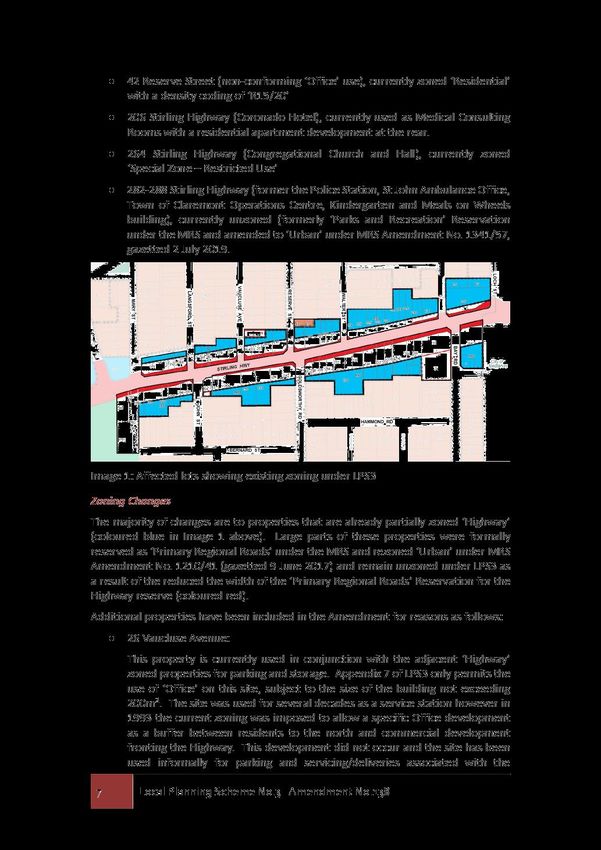
Ordinary Council Meeting Minutes                                                                                    15 September 2020

Order Of Business

1    Declaration of Opening/Announcement of Visitors ............................................................4
2    Record of Attendance/Apologies/Leave of Absence (Previously Approved) ...................4
3    Disclosure of Interests ...........................................................................................................4
4    Response to Previous Public Questions Taken on Notice .................................................4
5    Public Question Time .............................................................................................................5
6    Public Statement Time ...........................................................................................................5
7    Applications for Leave of Absence .......................................................................................5
8    Petitions/Deputations/Presentations ....................................................................................5
9    Confirmation of Minutes of Previous Meetings ...................................................................5
10   Announcement of Confidential Matters for which the Meeting may be Closed to
     the public .................................................................................................................................5
11   Business Not Dealt with From a Previous Meeting .............................................................5
12   Reports of Committees ..........................................................................................................5
13   Reports of the CEO.................................................................................................................6
     13.1         Liveability ....................................................................................................................6
                 13.1.1       Initiation of Scheme Amendment No. 138 - Stirling Highway - Eastern
                              Highway Precinct ...........................................................................................6
     13.2         Leadership and Governance ....................................................................................54
                 13.2.1       Monthly Statement of Financial Activity for the Periods ending 31 July
                              2020 .............................................................................................................54
                 13.2.2       List of Payments 1 to 31 August 2020 .........................................................83
14   Announcements by the Presiding Person .........................................................................94
15   Elected Members’ Motions of which Previous Notice has been Given ...........................94
16   New Business of an Urgent Nature Approved by the Presiding Person or by
     Decision of Meeting ..............................................................................................................94
17   Confidential Matters for which the Meeting may be Closed to the Public ......................95
     17.1         Leadership and Governance ....................................................................................95
                 17.1.1       Application for Rent Relief pursuant to Commercial Tenancies
                              (COVID-19 Response) Act 2020 .................................................................95
18   Future Meetings of Council .................................................................................................97
19   Declaration of Closure of Meeting ......................................................................................97

                                                                                                                                         Page 3
Ordinary Council Meeting Minutes                                            15 September 2020

                     MINUTES OF TOWN OF CLAREMONT
                       ORDINARY COUNCIL MEETING
HELD AT THE TOWN OF CLAREMONT, CLAREMONT COUNCIL CHAMBERS, 308 STIRLING
                          HIGHWAY, CLAREMONT
                 ON TUESDAY, 15 SEPTEMBER 2020 AT 7.00PM

1       DECLARATION OF OPENING/ANNOUNCEMENT OF VISITORS

His worship the Mayor, welcomed members of the public, press, staff and Councillors and declared
the meeting open at 7:00pm.

2       RECORD OF ATTENDANCE/APOLOGIES/LEAVE OF ABSENCE (PREVIOUSLY
        APPROVED)

PRESENT:
Mayor Jock Barker
Cr Peter Browne OAM, JP
Cr Peter Edwards
Cr Bruce Haynes
Cr Kate Main
Cr Annette Suann
Cr Peter Telford

IN ATTENDANCE:
Liz Ledger (Chief Executive Officer)
Andrew Smith (Director Infrastructure and Financial Management)
Bree Websdale (Director, Governance and People)
David Vinicombe (Director Planning and Development)
Georgia Stewart (Senior Marketing and Communications Officer)
Brett Williamson (Coordinator Governance and Risk)
Kerith Barbetti (Administration Officer, Governance)

0 members of the Public, 2 members of the Press

APOLOGIES:
Cr Paul Kelly
LEAVE OF ABSENCE:

Deputy Mayor Cr Jill Goetze
Cr Sara Franklyn

3       DISCLOSURE OF INTERESTS

Nil

4       RESPONSE TO PREVIOUS PUBLIC QUESTIONS TAKEN ON NOTICE

Nil

                                                                                         Page 4
Ordinary Council Meeting Minutes                                          15 September 2020

5        PUBLIC QUESTION TIME

Nil

6        PUBLIC STATEMENT TIME

Nil

7        APPLICATIONS FOR LEAVE OF ABSENCE

Nil

8        PETITIONS/DEPUTATIONS/PRESENTATIONS

Nil

9        CONFIRMATION OF MINUTES OF PREVIOUS MEETINGS

RESOLUTION 131/20
Moved: Cr Peter Browne OAM, JP
Seconded: Cr Annette Suann
That the minutes of the Ordinary Meeting of Council held on 1 September 2020 be confirmed.

For:          Mayor Jock Barker, Cr Peter Browne OAM, JP, Cr Peter Edwards, Cr Bruce
              Haynes, Cr Kate Main, Cr Annette Suann, Cr Peter Telford
Against:      Nil
                                                                              CARRIED 7/0

10       ANNOUNCEMENT OF CONFIDENTIAL MATTERS FOR WHICH THE MEETING
         MAY BE CLOSED TO THE PUBLIC

17.1.1   Application for Rent Relief pursuant to Commercial Tenancies (COVID-19 Response) Act
         2020

11       BUSINESS NOT DEALT WITH FROM A PREVIOUS MEETING

Nil

12       REPORTS OF COMMITTEES

Nil

                                                                                      Page 5
Ordinary Council Meeting Minutes 15 September 2020
13 REPORTS OF THE CEO
13.1 LIVEABILITY
13.1.1 INITIATION OF SCHEME AMENDMENT NO. 138 - STIRLING HIGHWAY - EASTERN
HIGHWAY PRECINCT
File Number: LND/00119, D-20-30012
Attachments: 1. Draft Scheme Amendment No. 138 - Stirling Highway - Eastern
Highway Precinct ⇩
Author: Josh Wilson, Urban Planner
David Vinicombe, Director Planning and Development
Authoriser: Liz Ledger, Chief Executive Officer
Proposed Meeting Date: 15 September 2020
Date Prepared: 2 September 2020
DA No.: N/A
60/90 Days Due Date: N/A
Property Owner: Multiple
Applicant: N/A
Lot No.: Multiple
Area of Lot: Multiple m2
Zoning: Multiple
Enabling Legislation: Planning and Development Act 2005 (PD Act)
Planning and Development (Local Planning Schemes)
Regulations 2015 (LPS Regs)
Local Planning Scheme No.3 (LPS3)
Stirling Highway Local Development Plan (SHLDP)
State Planning Policy 7.3 Residential Design Codes Volume 2 -
Apartments (RDC Vol. 2 Apartments
SUMMARY
Draft Scheme Amendment No. 138 to Local Planning Scheme No. 3 (LPS3) is presented to
Council for initiation and consent to advertise.
This Amendment is the last of three Amendments that implement the Stirling Highway Local
Development Plan (SHLDP), which was adopted by Council in 2016. Initiation of the
Amendment has been delayed to correlate the new provisions with the new Residential
Design Codes Volume 2 – Apartments (RDC Vol. 2 Apartments) and take into account impact
assessment and resultant additional design requirements from recent applications for
development along the Highway.
The Amendment varies the SHLDP proposals for the Eastern Highway Precinct by
recommending a Residential density code of ‘R-AC3’ instead of ‘R100’ in the ‘Highway’ zone
to more accurately reflect the intentions of the SHLDP relative to the RDC Vol. 2 Apartments.
Significant protections for adjacent residential properties are included as part of the proposed
provisions. These include fixed height limits, setbacks based on building height and
overshadowing limits.
Item 13.1.1 Page 6
Ordinary Council Meeting Minutes 15 September 2020
Recommended that Council initiate the Amendment for set appropriate guidelines for mixed-
use commercial and apartment development in the Eastern Highway Precinct along Stirling
Highway.
PURPOSE
For Council to consider initiation of Scheme Amendment No. 138 to LPS3 to reflect future
development requirements for mixed-use commercial and apartments promoted by Council’s Stirling
Highway Local Development Plan (SHLDP) in the Eastern Highway Precinct.
BACKGROUND
Scheme Amendment No. 138 is the continuation of long-term strategic planning for Stirling Highway
by the Town.
It is based on the following strategic documents prepared by the Town:
Clearly Claremont Local Planning Strategy 2011
Housing Capacity Study 2013
Stirling Highway Local Development Plan 2016 (SHLDP) which was adopted by Council on
5 July 2016 and reviewed by Council on 21 July 2020.
These documents built on each other to provide more detailed and refined recommendations for
future development along Stirling Highway as part of Council’s strategy to achieve housing growth
targets set by the Western Australian Planning Commission (WAPC).
The most recent document, the SHLDP, forms the basis of this Amendment. The SHLDP was
approved by the Town in 2016 and amended in July 2020 (Rev. 1). It is the local planning framework
document used to prepare this Amendment as it establishes the Town’s vision for future
development along Stirling Highway and provides background, research and reasoning to support
this vision.
The SHLDP establishes the following broad outcomes for this section of Stirling Highway:
Building heights of 6-8 storeys
Residential density code of R100 with a plot ratio of 1.3
Stepped building setbacks to ensure residential properties to the south are not affected by
overshadowing
Nil setbacks to Stirling Hwy (allowing for future widening)
Commercial uses at ground level with commercial and residential uses above.
The SHLDP proposes the creation of a ‘human scale’ corridor of six storey development along the
Highway with ‘Designated Landmark Sites’ having the capacity to rise to eight storeys. The concept
of human scale is scientifically based on providing social connection between residents and
surrounding community. Evidence shows that when apartments are more than six storeys high, the
sense of connection between residents and the outside world (and vice versa) decreases
significantly. This is desirable as a way of improving the social sustainability of development in the
Town and maintaining a strong sense of community.
It is acknowledged that the additional two storeys permitted on ‘Designated Landmark Sites’ is
slightly inconsistent with the ‘human scale’ intent. The additional height is desired on these sites to
create visual landmarks and to provide variety in building form along Stirling Highway. Linking
building height to strong community, heritage and environmental outcomes as proposed will
encourage best-practice and innovative designs that create a lasting benefit to the community. It
also recognises that Stirling Highway is a car dominated (rather than pedestrian) setting and that
higher apartments will be less impacted by noise which is a desirable outcome.
Item 13.1.1 Page 7
Ordinary Council Meeting Minutes 15 September 2020
Recommended changes to LPS3 and a draft Local Planning Policy (LPP) were included in the
SHLDP. These have been reviewed in light of more detailed investigation and the new RDC Vol.2
– Apartments requirements. Changes from these draft recommendations are intended to deliver an
improved vision for development along the Highway consistent with the SHLDP objectives and
proposals.
This Scheme Amendment for the Eastern Highway Precinct as identified under the SHLDP is
required following Scheme Amendments Nos 136 and 137 which addressed the Western Residential
and Central Town Centre Precincts also identified under the SHLDP. They were gazetted in
December 2019. Significant redevelopment is expected in the Eastern Highway Precinct and the
intent of this Scheme Amendment is to enable this development while ensuring the impact on
adjacent residential properties is minimised. Amendment No. 138 is more complex than the other
two Amendments as it involves a number of text modifications to reflect the new Residential Design
Codes Volume 2 – Apartments (RDC Vol. 2 Apartments) and hence has taken longer to prepare.
Community consultation on the SHLDP was undertaken in 2016 as part of the SHLDP to inform the
preparation of this and the other related Amendments. In addition, recent development applications
for 256 Stirling Highway and 1 Airlie Street have highlighted further issues that need to be addressed
in the Amendment than initially identified under the SHLDP. The proposed changes are intended to
encourage quality redevelopment along Stirling Highway that is of benefit to the whole community
while protecting the residential amenity of adjacent housing areas which contain significant numbers
of Heritage Listed properties, quality single houses and tree-lined streets.
This Amendment has also resulted from two Metropolitan Region Scheme (MRS) Amendments:
MRS Amendment 1210/41 reduced the width of the Primary Regional Road Reserve for
Stirling Highway from 80m to approximately 35m, leaving large sections of privately owned
land on either side of the Highway in the ‘Urban’ MRS zone but unzoned under LPS3.
MRS Amendment 1341/57 included the rezoning of the 282-288 Stirling Highway from
‘Parks and Recreation Reserve’ to ‘Urban’ under the MRS, but unzoned under LPS3. The
affected land requires zoning under LPS3 which is addressed by this Amendment.
PAST RESOLUTIONS
Ordinary Council Meeting 9 September 2017, Resolution No. 139/17:
That Council:
1. Initiate Scheme Amendment No. 136 to Town Planning Scheme No. 3 in order to:
a) Zone all unzoned parcels of Urban land north west and south east of Stirling Highway to
the west of the Stirling Road/Queenslea Drive intersection excluding 355 Stirling
Highway (cnr Stirling Road) to “Residential”, “Educational” or “Special Development”
zone to match the adjoining zoning of the remainder of the property and apply the
associated R-Codings of R30 and R40 to the Residential zones.
b) Advise the Minister for Planning that Amendment No. 136 to Town Planning Scheme No.
3 is a standard amendment as it will make the Scheme consistent with the Metropolitan
Region Scheme.
c) Amend the Scheme Map accordingly.
2. Initiate Scheme Amendment No. 137 to Town Planning Scheme No. 3 in order to:
a) Zone all unzoned parcels of Urban land north and south of Stirling Highway to the east
of the Stirling Road/Queenslea Drive intersection (including 355 Stirling Highway (cnr
Stirling Road) and to the west of Mary Street to “Town Centre”.
b) Rezone the remainder of 355 Stirling Highway (cnr Stirling Road) from “Special Zone
Restricted Use” to “Town Centre”, 2 Queenslea Drive (Lot 2) from “Highway” to “Town
Centre”, 1 Freshwater Parade (Lot 203) from “Special Zone Restricted Use” to “Town
Centre”, 2 Freshwater Parade (Lot 17), 322 to 324 Stirling Highway (Lots 11, 10, 9, 8
Item 13.1.1 Page 8
Ordinary Council Meeting Minutes                                                15 September 2020

              and 7) and 57 Bay View Terrace (Lot 12) from “Highway” from “Highway” to “Town
              Centre”.
      c)      Advise the Minister for Planning that Amendment No. 137 to Town Planning Scheme No.
              3 is a standard amendment as it will make the scheme consistent with the Metropolitan
              Region Scheme.
      d)      Amend the Scheme Map accordingly.
3.    Authorise the Mayor and the Chief Executive Officer to endorse the Scheme Amendment
      documents.
4.    Forward a copy of the Amendment documentation to:
      (a)     The Environmental Protection Authority in accordance with Section 81 of the Planning
              and Development Act 2005;
      (b)     The Western Australian Planning Commission for information.
5.    On receipt of advice from the Environmental Protection Authority under Section 48A of the
      Environmental Protection Act indicating that the Amendment need not be subject to an
      environmental assessment, advertise Amendment No. 136 in accordance with the Town
      Planning Regulations for not less than 42 days.
6.    On receipt of advice from the Environmental Protection Authority under Section 48A of the
      Environmental Protection Act indicating that the Amendment need not be subject to an
      environmental assessment, and upon finalisation of proposals for the Town Centre Activity
      Centre Plan, advertise the Activity Centre Plan and Amendment No. 137 proposals in
      accordance with the Town Planning Regulations for not less than 42 days.
7.    Defer initiation of Amendment No. 138 to Town Planning Scheme No. 3 relative to properties
      located in the Eastern Highway Precinct of the Stirling Highway Local Development Plan to
      allow further consideration of specific development provisions and public engagement be
      undertaken.

STATUTORY CONSIDERATIONS
Section 75 of the Planning and Development Act 2005 (PD Act) permits Council to amend its Local
Planning Scheme as stated below:
75. Amending scheme
A local government may amend a local planning scheme with reference to any land within its district,
or with reference to land within its district and other land within any adjacent district, by an
amendment:
(a)   prepared by the local government, approved by the Minister and published in the Gazette; or
(b)   proposed by all or any of the owners of any land in the scheme area, adopted, with or without
      modifications, by the local government, approved by the Minister and published in the Gazette.

Amendments are required to be undertaken in accordance with the Planning and Development
(Local Planning Schemes) Regulations 2015 (LPS Regs). The LPS Regs require that Amendments
be classified as Basic, Standard or Complex as this determines the regulatory process for adoption.
Justification for the type of amendment must be stated in Council’s resolution to initiate an
Amendment.

The proposed amendment is classed as complex based on the following criteria as set out in the
LPS Regs:
      (c) an amendment relating to development that is of a scale, or will have an impact, that is
          significant relative to development in the locality
If the Amendment is initiated, documentation will be referred to the Environmental Protection
Authority (EPA) for environmental assessment and consent to advertise. Basic and Complex
Amendments are referred to the WAPC as required by the LPS Regs and to ensure the

Item 13.1.1                                                                                  Page 9
Ordinary Council Meeting Minutes 15 September 2020
Amendment’s classification is correct. If permitted, the Complex Amendment will be advertised in
accordance with the LPS Regs for a period of not less than 60 days. Any submissions received will
be addressed in a second report to Council which will consider any submissions and determine
whether to finalise the Amendment (with or without modifications) or to not proceed. The
Amendment will then be forwarded to the Minister for Planning, Lands and Heritage for final
determination.
HERITAGE
The majority of properties contained within the Amendment proposals are not included on the Town’s
Heritage List, however the Amendment will potentially have some impact on the following properties.
Rezoning does not have an immediate impact on the heritage values of a place, but consideration
should be given to any consequential redevelopment of a site which may incentivise the demolition
or significantly alter the heritage place:
206 Stirling Highway is the former Highway Hotel (Coronado), now Medical Consulting
Rooms. It is entered in the State Register of Heritage places and any proposed development
must be referred to the State Heritage Office for their advice (NB – the proposal plans to
extend the current ‘Special Zone – Restricted Use’ over this site and will therefore have no
impact on the heritage provisions applying to this place).
222 Stirling Highway is a 1902 Federation Bungalow now used as commercial premises. It
is entered in the Town’s Heritage List as a Management Category B, and is an important
remnant of the heritage fabric of this area of the Highway.
236 Stirling Highway is a 1905 Federation Bungalow now used as commercial premises. It
is entered in the Town’s Heritage List as a Management Category B, and is an important
remnant of the heritage fabric of this area of the Highway.
256 Stirling Highway is entered in the Town’s Heritage List as the site of the former Halfway
Tree (NB – development has recently been approved on this site which acknowledges the
significance of the place).
262-64 Stirling Highway is the Congregational Hall and Church, which are entered as a group
in the State Register of Heritage Places. Any proposed development must be referred to the
State Heritage Office for their advice.
280 Stirling Highway is the former Electric Substation, recently renovated and now used as
commercial premises. It is entered in the Town’s Heritage List as a Category B and is a vital
part of the heritage fabric of Claremont.
282 Stirling Highway is the St John Ambulance sub-center which is a 1965 building showing
mid-century design principles. It is entered in the Town’s Heritage List as a Category B and
should be considered a significant part of the heritage fabric along the Highway (NB – the
Highway widening will result in at least the removal of the front façade and one third of this
building).
COMMUNICATION/CONSULTATION
It is noted that initiation of this Amendment was delayed in 2017 to allow further consideration of
specific development provisions and public engagement be undertaken. The initial intent of this
delay was based on a preference review the proposed provisions against forthcoming (at that time
revisions to the RDC to improve the design requirements relating to apartment development) and
also to seek further comment from surrounding residents.
It is noted that this Amendment has been reviewed against the provisions of the new RDC Vol. 2
Apartments requirements and has been subject to public consultation relative to two recent
Development Applications along the Highway. Given this background, and a directive from the
Department of Planning Land and Heritage to progress this Amendment, the formal LPS Regs
consultation requirements which will apply should Council adopt the proposed Amendment will
address this matter. This will include a Notice in a local newspaper and letters sent to affected
Item 13.1.1 Page 10Ordinary Council Meeting Minutes 15 September 2020
landowners and those in the vicinity of the affected land. The Amendment will be publically available
on the Town’s website and at the administration office.
DISCUSSION
Zoning Changes
The majority of properties affected by this Amendment are those that are currently wholly or partially
zoned ‘Highway’ under LPS3. In addition, the following associated sites are included in the
Amendment:
26 Vaucluse Avenue, currently zoned ‘Special Zone – Restricted Use’
42 Reserve Street (non-conforming ‘Office’ use), currently zoned ‘Residential’ with a density
coding of ‘R15/20’
206 Stirling Highway (Coronado Hotel), currently used as Medical Consulting Rooms with a
residential apartment development at the rear.
264 Stirling Highway (Congregational Church and Hall), currently zoned ‘Special Zone –
Restricted Use’
282-288 Stirling Highway (former the Police Station, St John Ambulance office, Town of
Claremont Operations Centre, Kindergarten and Meals on Wheels building), currently
unzoned (formerly ‘Parks and Recreation’ Reservation under the MRS) and amended to
‘Urban’ under MRS Amendment No. 1341/57, gazetted 2 July 2019.
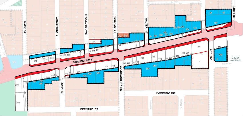
The affected unzoned properties (coloured white) along with the existing ‘Highway’ (coloured blue),
‘Residential’ (coloured brown) and ‘Special Zone – Restricted Use’ (coloured white with red border)
zonings are shown below:
The majority of changes are to properties that are already partially zoned ‘Highway’. Large parts of
these properties were formally reserved as ‘Primary Regional Roads’ under the MRS and rezoned
‘Urban’ under MRS Amendment No. 1210/41 (gazetted 9 June 2017) and remain unzoned under
LPS3 as a result of the reduced the width of the ‘Primary Regional Roads’ Reservation for the
Highway reserve (coloured red).
Additional properties have been included in the Amendment for reasons as follows:
26 Vaucluse Avenue:
This property is currently used in conjunction with the adjacent ‘Highway’ zoned properties
for parking and storage. Appendix 7 of LPS3 only permits the use of ‘Office’ on this site,
Item 13.1.1 Page 11Ordinary Council Meeting Minutes 15 September 2020
subject to the size of the building not exceeding 200m2. The site was used for several
decades as a service station however in 1993 the current zoning was imposed to allow a
specific Office development as a buffer between residents to the north and commercial
development fronting the Highway. This development did not occur and the site has been
used informally for parking and servicing/deliveries associated with the commercial
development fronting the Highway ever since. This use is inconsistent with the SHLDP and
is unnecessarily restrictive. It is proposed to retain the existing ‘Special Zone (Restricted
Use)’ but alter the permitted use to include ‘Dwelling (Self-contained)’ and alter the
development standards to comply with the Highway zone. This will encourage
redevelopment in conjunction with the adjacent commercial properties while retaining the
current restriction on commercial uses to ‘Office’ so as to limit impact on the adjacent
residential property to the north.
42 Reserve Street:
This property is zoned ‘Residential’ however has non-conforming use rights as an ‘Office’.
The rear is used for parking by the adjacent ‘Highway’ zoned properties. Similar to 26
Vaucluse, this use is inconsistent with the SHLDP and is unnecessarily restrictive. Rezoning
acknowledges the commercial use of the site and will encourage redevelopment in
conjunction with the adjacent commercial properties.
206 Stirling Highway:
This property is zoned ‘Special Zone – Restricted Use’. This zone includes significant
heritage protection controls under LPS3 Appendix 7 while allowing redevelopment of the rear
of the site, which occurred in 2000. Because of this, and as further redevelopment is unlikely,
it is proposed to retain the existing zoning and extend it to cover the unzoned portion of the
site.
264 Stirling Highway:
This property is zoned ‘Special Zone – Restricted Use’. The existing permitted use of this
property under Appendix 7 of LPS3 states:
“All the uses that the land may be used for in the Highway Zone as determined by Table 1
Land Use Table and in addition may be used for the purpose of conducting civil ceremonies.
A minimum of 22 car bays are to be available for the wedding guests.”
Redevelopment of the rear of the site has removed the majority of parking and it is no longer
possible to provide 22 car bays for civil ceremony uses. Because of this the purpose of the
current zoning no longer exists and the zoning should revert to ‘Highway’ consistent with the
SHLDP. It is noted however that the site contains the heritage Listed Congregational Church
which will place significant constraints on the capacity for the site to be redeveloped
consistent with the SHLDP.
282-288 Stirling Highway:
These properties are owned by the State Government and were previously reserved under
the MRS for ‘Parks and Recreation’ and ‘Primary Regional Roads’. MRS Amendment Nos
1210/41 (gazetted 9 June 2017) and 1341/57 (gazetted 2 July 2019) changed this to ‘Urban’
in response to the reduced Highway Reservation requirements, acknowledges the existing
developments on the site, and allow for the sale of the former Police Station site as a State
Government asset and to allow for future redevelopment. The Town has a Management
Order over (approximately) three quarters of the site (not including the former Police Station
site) and is engaged in ongoing discussions with the State Government about the future of
this land.
R-Code Changes
The Residential Density Codes Volume 2 – Apartments (RDC Vol. 2 Apartments) establish the
permitted amount of residential development on land. RDC Vol. 2 Apartments primarily determine
Item 13.1.1 Page 12Ordinary Council Meeting Minutes 15 September 2020
the height of buildings, residential plot ratios and building setbacks (in addition to other requirements
designed to improve the amenity of apartments and address impacts on surrounding properties).
It is proposed to increase the density code within the ‘Highway’ zone from ‘R40’ to ‘R-AC3’ (Activity
Centre 3). This is higher than the ‘R100' recommended for the Eastern Highway Precinct in the
SHLDP for reasons set out below.
The ‘RAC-3’ density coding was not considered in the preparation of the SHLDP because the Local
Development Plan was prepared prior to the release of the RDC Vol. 2 Apartments.
The RDC Vol.2 Apartments provides a new classification system for desired streetscapes that
groups the density codes into Streetscape Character Types, inclusive of Suburban Contexts (Low-
Rise, Medium-Rise and Neighbourhood Centre) and Urban Contexts (Higher Density Residential,
Mid-Rise Urban Centres and High Density Urban Centres). The Streetscape Character Types are
further differentiated to default settings applying the Low-rise residential (R40 and R50), Medium–
rise residential (R60 and R80) and High density urban residential (R100 and R160). Where
designated by local government in a Local Planning Scheme, Activity Centre Plan, Structure Plan,
Local Development Plan or Local Planning Policy, mixed commercial use options are provided for a
Neighbourhood Centre (R-AC4), Medium-rise urban centre (R-AC3), High density urban centres (R-
AC2 and R-AC1) and Planned areas (R-AC0). The purpose of each is to ensure that the primary
controls set out in Table 2.1 of the RDC Vol. 2 Apartments properly align with intended streetscape
outcomes.
Under this new system, the desired outcome for Stirling Highway is primarily aligned with the ‘Mid-
rise urban centres’ (equivalent of ‘Medium–rise urban centres’) category which is defined as follows:
Mid-rise Urban Centres
Context: Urban centres may include town/district centres, urban corridors, activity centres and
station precincts. Urban centres typically comprise development up to approximately 6-storeys
that has direct street frontage and is often built to boundary. Urban centres are highly walkable
with close proximity to high-frequency transit services, public open space, commercial and/or
retail uses and community infrastructure.
Character: Urban centres are characterised by mid-rise buildings and contiguous, pedestrian
friendly street frontages that include some activation. New development should create an
attractive and coherent street frontage that complements adjoining buildings, has a pedestrian
scale and provides passive surveillance of the street.
Mid-rise (Medium-rise) urban centres are designated as aligning with the R-AC3 density code and it
is recommended the Town adopt this density code to ensure the desired built-form and streetscape
character as identified in the SHLDP is achieved.
The following table outlines the existing and proposed key development requirements for the
‘Highway’ zoned properties under LPS3, the SHLDP and RDC Vol. 2 Apartments:
Item 13.1.1 Page 13Ordinary Council Meeting Minutes 15 September 2020
R40 SHLDP R100 R-AC3 R-AC2 R-AC1
proposals
(Existing) (Primary (Proposed) (Considered (Considered
SHLDP for SHLDP for SHLDP
proposal) ‘Designated ‘Designated
Landmark Landmark
Sites’) Sites’)
Maximum 2 storeys 6 storeys 4 storeys 6 storeys 7 storeys (24m) 9 storeys (30m)
height (9m) (21.6m) for (15m) (21m)
all properties
other than
‘Designated
Landmark
Site’ – 8
storeys
(28.8m)
Maximum 0.6 Former RDC 1.3 2.0 2.5 3.0
plot ratio requirement
of 1.25
envisaged
Boundary 1 storey Former RDC 2 storeys, 3 storeys 4 storeys 4 storeys
wall height to one requirement to one
boundary of 6m boundary
only and average only and
not envisaged not
exceed exceed
2/3 2/3
boundary boundary
length length
Minimum 3m Former RDC 6m 6m Nil Nil
rear requirement
setback of 3-4m
envisaged
As shown, the primary development requirements for the majority of properties along the Highway
as proposed by the SHLDP align better with the ‘R-AC3’ requirements (other than plot ratio and
requirements for ‘Designated Landmark Sites’ under the SHLDP).
The envisaged height of six storeys under the SHLDP no longer aligns with the ‘R100’ requirement
of four storeys, which is provided for under the ‘R-AC3’ coding. The envisaged plot ratio of 1.25
under the former RDC requirements for ‘R100’ does not align with revised plot ratio standards of 2.0
under the RDC Vol. 2 Apartments requirements to reflect the six storey built form outcome.
Accordingly, the proposal to apply the ‘R-AC3’ requirements for the Highway brings the SHLDP
proposals into alignment with the modern RDC Vol. 2 Apartments requirements.
It is noted that the SHLDP provides for an additional two storeys to be developed on ‘Designated
Landmark Sites’ which would result in a total height of 27m of the RDC Vol.2 Apartments
requirements. Within the Eastern Highway Precinct, these sites include 207 Stirling Highway (Lot
333) and 256 Stirling Highway (Lot 102 – SHLDP Rev. 1 July 2020). The SHLDP proposal of eight
storeys for these sites does not fit well with the alternatives provided for under the RDC Vol.2
Apartment density codings. As indicated above, options considered of ‘R-AC2’ provide for a height
of seven storeys and ‘R-AC1’ provides for a height of nine storeys. As a result, the height proposed
for ‘Designated Landmark Sites’ are considered to be more appropriately controlled by height
requirements under cl.40(9) of LPS3 (see below) than by applying either of these density codings.
Item 13.1.1 Page 14Ordinary Council Meeting Minutes 15 September 2020
Similarly, plot ratio requirements for ‘Designated Landmark Sites’ under ‘R-AC2’ (2.5) and ‘R-AC1’
(3.0) under the RDC Vol. 2 Apartments requirements do not reflect the eight storey built form
outcomes. As a result, the plot ratio for ‘Designated Landmark Sites’ are considered to be more
appropriately controlled by new plot ratio requirement additions under cl. 70 of LPS3 (see below)
than by applying either of these density codings.
It should be noted that the increase in plot ratio provided for under the ‘R-AC3’ and cl.70 proposals
above are balanced by a far more comprehensive assessment framework under the RDC Vol.2 -
Apartments. While previous assessment criteria primarily dealt with height, setbacks and car
parking, the new requirements include Design Elements relating to such matters as tree canopies,
interface with the public domain, response to site, light and ventilation, internal design of apartments,
universal design and energy/water efficiency. These requirements are intended to drive substantially
improved design outcomes than previously.
These modifications will allow for residential development that meets the desired built form outcomes
adopted by Council in the SHLDP.
Scheme Text Changes
Significant text changes are proposed to LPS3. This is to allow for increased development while
ensuring adjacent low-density residential properties are not significantly impacted by overshadowing
and building bulk. Controls for building heights and setbacks are proposed to be incorporated into
the Scheme to add a measure of control over LPS provisions, which until now have not been subject
to discretion.
‘Due regard’ considerations have been recently highlighted in a Development Approval at granted
(by the Metro Inner-North Joint Development Assessment Panel) for 1 Airlie Street. In that specific
case, LPS3 required the site to be controlled by a Structure Plan, however the LPS Regs provided
for this to be varied and the SHLDP height requirements were considered a ‘due regard’ matter
where discretion may apply taking into account other design requirements under the RDC Vol. 2
Apartments. In this case the height was varied as the built form impacts were primarily contained
within the property due to the size and orientation of the property and accordingly the amenity
impacts on surrounding development was considered to be substantially mitigated.
It is noted that in a more recent case, an eight storey development was approved (as a variation to
the SHLDP) at 256 Stirling Highway. In that instance the orientation and size of the lot resulted in
an acceptable overshadowing impact on the property to the south as determined by the Orientation
Element Objectives of the RDC Vol. 2 Apartments. Again, in this instance, the ‘Urban’ zoning under
the MRS allowed consideration of the height a ‘due regard’ consideration.
While ‘due regard’ considerations in exercising discretion on Design Elements of the RDC Vol. 2
Apartment and LPS3 requirements are likely to become more prevalent in the development industry,
the following amendments to LPS3 provisions will provide some measure of guidance to reduce
amenity impacts on adjacent low-density residential properties and address some of the applicable
RDC Vol. 2 Apartments density coding shortcomings as detailed above.
Existing Clause Proposed Change Reason for Change
Clause 40(9) - Height of Replace cl.40(9) with the The SHLDP recommends a
Buildings in the Highway following: six storey limit with
zone ‘Designated Landmark Sites’
In the Highway zone, a building of up to eight storeys.
In the Highway Zone a may be constructed up to a
building shall not exceed height of six storeys or 21m Height limits are required to
12m in height provided provided no adverse amenity allow for the intended
that, if the Council is of the effects result on adjacent development along Stirling
opinion that it is necessary residential properties to the Highway while protecting the
to do so in a particular south as determined by the amenity of adjacent residential
case to avoid any adverse Orientation Element Objectives property to the south and to
effect on the amenity of contained in the Residential ensure the footpath on the
any part of the Residential southern side of Stirling
Item 13.1.1 Page 15Ordinary Council Meeting Minutes 15 September 2020
Existing Clause Proposed Change Reason for Change
Zone, the Council may Design Codes Volume 2 – Highway is not overshadowed
require a building to be Apartments except as follows: to the extent that it will
constructed to a lower discourage pedestrian use.
height in than 12m. a) Where a site is a
‘Designated Landmark Adverse amenity impacts
Site’ under the Stirling under the RDC Vol. 2
Highway Local Apartments requirements are
Development Plan, an measured against the
additional two storeys Orientation Element
to a maximum height of Objectives which seek to
eight storeys or 27m ensure that building layouts
are permitted providing respond to streetscape,
no adverse amenity topography and site attributes
effects result on while optimising solar and
adjacent residential daylight access within the
properties to the south development and the building
as determined by the form and orientation minimises
Orientation Element overshadowing of the
Objectives contained in habitable rooms, open space
the Residential Design and solar collectors of
Codes Volume 2 – neighbouring properties during
Apartments and the mid-winter.
footpath on the
southern side of Stirling A change to include storeys as
Highway is not a height measure in addition
overshadowed by more to heights in meters is
than 50% of its width. proposed to align with the
RDC Vol.2 Apartments
b) Where the top floor is requirements and to
limited to service areas encourage better built
and/or ancillary outcomes including high
communal facilities internal ceilings and rooftop
(setback so as to not amenities.
be visible from the
footpath on the direct Inclusion of minimal facilities
opposite side of the on the rooftop is not
Highway and considered significant and is
containing any roof encouraged providing adverse
structure not exceeding amenity impacts do not result.
more than 50% of the
floorspace below) and
designed to ensure no
adverse amenity
effects result on
adjacent residential
properties to the south
as determined by the
Orientation Element
Objectives contained in
the Residential Design
Codes Volume 2 –
Apartments, shall not
be counted as an
additional storey.
Clause 44 - Stirling Replace cl.44 with the following: The intent of the existing
Highway Vehicular Access clause is to reduce the
Where land having a frontage to number of crossovers on
Where land having a Stirling Highway has sufficient Stirling Highway as a means
frontage to Stirling alternative means of safe of improving traffic flow and
Highway has an alternative vehicular access to another safety.
means of vehicular access street, either directly or via a
Item 13.1.1 Page 16Ordinary Council Meeting Minutes 15 September 2020
Existing Clause Proposed Change Reason for Change
to another street or road, a Right of Way or Right of As evident from assessing the
person shall not create and Carriageway connecting to a proposed development at 256
direct vehicular access to side street, a person shall not Stirling Highway, clarity is
or from that land to Stirling create and direct vehicular desirable to ensure that where
Highway. access to or from that land to sufficient safe alternative
Stirling Highway. access is available from a
It is noted that this clause Right of Way or Right of
works in conjunction with Carriageway (in addition to a
cl.72 (see below) which street), access directly to
allows Council to approve Stirling Highway should not be
direct vehicle access to the permitted.
Highway as a temporary
measure or to require
access over a site to the
benefit of an adjoining
property.
Clause 70 - Objectives Replace cl.70 with the following: The objectives of the Highway
zone require updating to
In considering an In considering an application for match the objectives identified
application for planning Development Approval in the in the SHLDP. Additional
approval for development Highway zone the Council, in criteria are also recommended
in the Highway Zone the addition to any other matter it is based on the Town’s Local
Council, in addition to any required or permitted to Planning Strategy (Clearly
other matter it is required consider, shall have regard to Claremont 2011).
or permitted to consider, the following objectives:
shall have regard to the
following objectives: (1) The creation of a ‘human
scale’ corridor of six storey
(1) a mixture of residential development along the
and commercial Highway, and where
developments; appropriate and identified
as a ‘Designated Landmark
(2) the restriction, to a Site’ under the Stirling
minimum, of direct Highway Local
vehicular access to Development Plan, the
and from Stirling building height may be
Highway; increased to eight storeys
providing non adverse
(3) the volume of traffic impacts on the amenity of
likely to be generated; adjacent land results.
(4) a landscape and (2) Encouragement of a
townscape within the pedestrian-friendly
Zone compatible with environment along the
the desired scale of Highway.
Stirling Highway;
(3) Preserving the commercial
(5) the preservation of all nature of the Highway zone
buildings referred to in as part of a mixed-use
Clause 78. residential Precinct by
ensuring the ground floor of
all developments is used
for commercial purposes.
(4) Achieving significant
residential infill
development.
(5) Restriction, to a minimum,
of direct vehicle access to
and from Stirling Highway.
Item 13.1.1 Page 17Ordinary Council Meeting Minutes 15 September 2020
Existing Clause Proposed Change Reason for Change
(6) Achieving a high level of
environmental sustainability
through design, materials,
energy and water
consumption and
renewable energy
generation.
(7) The preservation of all
buildings referred to in
Clause 78.
Clause 71 - Building Replace cl.71 with the following: The existing 7m front setback
Setback Distances requirement is primarily
(1) Setbacks to Stirling redundant given the new cl.70
Where the Council grants Highway for mixed-use objectives detailed above to
an application for planning development may be nil, encourage a ‘human scale’
approval the minimum provided that any mixed-use residential and
setback from Stirling development exceeding commercial streetscape along
Highway shall be 7 metres four storeys is required to the Highway as promoted by
except that Council may be setback a minimum of 3 the SHLDP.
vary that distance having metres, or further to ensure
regard to the following that any overshadowing to The 3 metre front setback for
matters: a footpath on the direct development above four
opposite side of the storeys is consistent with the
(1) the need for shops Highway to the south does above objective as articulated
and other commercial not exceed 50% of the in the SHLDP.
uses to be exposed to footpath width.
the Highway; Side and rear setback controls
(2) Setbacks to Residential are necessary where
(2) the desirability of zoned properties are development abuts
variety in setback dependent on the height of ‘Residential’ zoned land. The
distances; the building as follows: proposed setbacks are greater
than required under the RDC
(3) the desirability of (a) Where a Residential zoned Vol.2. Apartments. In the
reducing noise impact property is located to the Town’s opinion, those limits do
from the Highway; south, the development not adequately consider the
must be set back so as not impact of tall buildings on
(4) the desirability of to cause any unreasonable existing houses. These
providing space for overshadowing of the impacts include
landscaped area; and Residential zoned property, overshadowing and increased
as determined in building bulk compared to
(5) the desirability of accordance with the previous building standards
providing flexibility in Orientation Element along the Highway.
residential Objectives contained in the
development. Residential Design Codes The proposed setbacks are
Volume 2 – Apartments. similar to existing
requirements for southern
(b) Where a Residential zoned boundaries, where
property is located to the overshadowing is of most
east, west or north, the concern. Proposed east, west
development in the and north setbacks are less as
Highway zone immediately overshadowing is technically
adjacent that Residential measured to the south.
zoned property must be set
back at least 1m for every Limited discretion is proposed
1m of building height above to allow development closer to
the relative height of the boundary where this can
development contained on screen upper floors from view.
the Residential zoned The benefit to immediately
property. adjacent residences is that
Item 13.1.1 Page 18Ordinary Council Meeting Minutes 15 September 2020
Existing Clause Proposed Change Reason for Change
new developments will appear
Council may at its discretion, mostly as two-storey buildings,
vary the requirements of sub- with upper floors largely
clauses 2(a) and 2(b) above to screened from view. This can
allow part of a development up reduce the impact of
to 6m high to be constructed no technically compliant
less than 2m from a lot overlooking from multiple
boundary in order to provide apartments by screening lower
visual screening of the building level apartments further
from view of the adjacent removed from the boundary
residential property. Council will from view.
only permit this when, in its
opinion, the reduced setback
achieves a beneficial outcome
for the adjacent property owner.
New Clause 71A – Plot Insert new cl.71A as follows: As indicated above, eight
Ratio storey apartment development
71A PLOT RATIO falls between the mixed-use
R-AC2 and R-AC1
The assigned plot ratio for eight requirements of 2.5 (for seven
storey ‘Designated Landmark storey development) and 3.0
Sites’ is 2.75, subject to (for nine storey development).
variation in consideration of the The new provision assign a
Plot Ratio Element Objective commensurate plot ratio,
under the Residential Design which may be varied in the
Codes Volume 2 – Apartments. same circumstances which
apply to plot ratio variations
under the Element Objective
which requires consideration
of the overall bulk and scale of
development which is
appropriate for the existing or
planned character of the area.
Clause 72 - Control of Delete sub-clause 3. Sub-clause 3 is contrary to the
Access intent of the SHLDP which
seeks to increase the level of
(1) The Council may in development along the
respect of any Highway to provide for mixed-
planning approval uses including ‘human scale’
require that an apartments.
easement be granted
over the land in favour
of any other parcel of
land for the purpose of
providing access for
vehicles from a street
or right of way other
than Stirling Highway.
(2) The Council may in
respect of any
planning approval,
require that the
development be so
designed as to allow
future access to be
taken from a street or
right of way other than
Stirling Highway and in
such cases may limit
Item 13.1.1 Page 19Ordinary Council Meeting Minutes 15 September 2020
Existing Clause Proposed Change Reason for Change
the time for which
access from Stirling
Highway may be
permitted to such time
as an adequate
alternative access to a
street or right of way is
not available.
(3) Where access is
available solely from
Stirling Highway the
Council may reduce
the extent of the
development to be
permitted on the site to
the extent it
determines in the
interest of safety and
convenience for users
of the Highway.
Appendix VII – Location Delete entry relating to 264 This entry relates to the
Particulars Relative to Stirling Highway Congregational Church which
Restricted Uses (cl.14A) is a significant Heritage Listed
building.
Location:
No. 264 Stirling Highway Redevelopment of the rear of
the site has removed the
Particulars of Land: majority of parking on the site
Lot 1 of Swan Location 621 and it is no longer possible to
on Plan 1133 and a portion provide 22 car bays for civil
of Certificate of Title ceremony uses. As a result
Volume 1738, Folio 887 the provision is no longer
and 889. applies and the zoning should
revert to ‘Highway’.
Permitted Use:
All the uses that the land The Heritage List protections
may be used for in the of buildings on the site will not
Highway Zone as be affected.
determined by Table 1
Land Use Table and in
addition may be used for
the purpose of conducting
civil ceremonies.
Standards/Conditions:
A minimum of 22 car bays
are to be available for the
wedding guests.
Appendix VII – Location Amend the Permitted Use and It appears that 26 Vaucluse
Particulars Relative to Standards/Conditions entries formed part of a former BP
Restricted Uses (cl.14A) relating to 26 Vaucluse as service station site and has
follows: been used for parking and
Location: storage/servicing of the
No. 26 Vaucluse Street Permitted Use: adjoining properties at 251-
Office and Dwelling (Self- 255 Stirling Highway for a
Particulars of Land: contained) number of years following
Portion of Swan Location demolition of the service
62 being Lot 36 on Plan Standards/Conditions: station in 1991. Council
1234 and a portion of the amended TPS3 in 1993
Item 13.1.1 Page 20Ordinary Council Meeting Minutes 15 September 2020
Existing Clause Proposed Change Reason for Change
land subject to Certificate Development of Office with a (Amendment No. 41) to
of Title Volume III, Folio gross leasable area not to provide an Office buffer to the
465. exceed 200m2 and Dwelling adjoining residential properties
(Self-contained) uses to accord to the north, however the
Permitted Use: with the requirements relating to Office use has not been
Office the Highway zone. developed and the site has
continued to be used
Standards/Conditions: informally for parking and
Gross leasable area of servicing/storage.
building not to exceed
200m2. The Restrictive Use limits
placed on development do not
fully align with the SHLDP. As
the site has a history of
commercial use and as
Amendment No. 41 intended
to provide for a buffer to the
commercial uses fronting the
Highway, it is recommended
that the Restricted Use
requirements be modified to
allow for Office and Apartment
development subject to all
development restrictions
placed in the Scheme for the
Highway zone. This will
ensure that a buffer is
maintained on the site to
separate the more intensive
commercial uses fronting the
Highway from the single
residential uses to the north as
intended by Amendment No
41.
In preparing this Amendment a further strategic project has been identified:
Stirling Highway Local Planning Policy
The SHLDP proposes both Scheme Amendments and an accompanying Local Planning Policy
(LPP) to guide future development in this section of Stirling Highway. Many elements of the draft
LPP were made redundant by the release of the RDC Vol. 2 Apartments in 2019. While the need
for a LPP is reduced it may still be beneficial in order to control aspects of new developments that
are not adequately addressed in the RDC Vol. 2 Apartments or this Amendment, such as access
and matters that relate to non-residential development. It is intended to commence work on the LPP
following Department of Planning Lands and Heritage permission to advertise Amendment No. 138
to ensure the LPP is adopted by the time the Amendment is gazetted.
FINANCIAL AND STAFF IMPLICATIONS
Costs of this Scheme Amendment include the direct costs of advertising and staff time. As identified
above, further strategic planning work is recommended relative to the preparation of a LPP following
this Amendment which will require additional costs and time. This has been allowed for in the
Planning Services budget.
This Scheme Amendment will allow additional new development in the Town. The SHLDP estimates
that the proposed changes will result in up to 332 additional dwellings in this section of the Highway,
however due to the increased density coding and associated plot ratio to reflect the SHLDP built
form for six storey development (eight storeys at ‘’Designated landmark Sites’) it is noted that the
actual development yield is likely to exceed this estimate considerably. Development promoted by
Item 13.1.1 Page 21Ordinary Council Meeting Minutes 15 September 2020
this Amendment will result in a significant increase to the Town’s rates base while adding modest
additional servicing costs. Overall this helps the Town maintain financial viability while minimising
costs to residents.
POLICY AND STATUTORY IMPLICATIONS
All Scheme Amendments are required to be undertaken in accordance with the LPS Regs.
STRATEGIC COMMUNITY PLAN
The proposal meets the following objectives of the Strategic Community Plan:
Liveability
We are an accessible community with well-maintained and managed assets. Our heritage is
preserved for the enjoyment of the community.
Balance the Town's historical character with complementary, well designed development.
Local Prosperity
Our businesses are thriving and integrated into the life of the Claremont community, and the town
centre is known as the premier visitor destination.
Plan for the development of attractive and thriving activity nodes to support small local
business.
URGENCY
The Town has been in discussions with the Department of Planning Lands and Heritage regarding
the need to zone the unzoned land along this section of Stirling Highway. The Department has
indicated that rezoning this land, with accompanying changes to reflect the Stirling Highway Local
Development Plan is a matter that the Town must address urgently.
CONCLUSION
Based on the above, it is recommended that Council initiate Amendment No. 138 as per the Officer’s
Recommendation below.
VOTING REQUIREMENTS
Simple Majority decision of Council (More than half the elected members present are required to
vote in favour).
RESOLUTION 132/20
Moved: Cr Bruce Haynes
Seconded: Cr Peter Telford
THAT Council:
1. Initiate Scheme Amendment No. 138 to amend Local Planning Scheme No. 3 by:
a. Zoning all unzoned portion of lots adjacent to Stirling Highway on the north
side of the Highway between Mary Street and Loch Street to ‘Highway’.
b. Zoning all unzoned portions of lots adjacent to Stirling Highway on the south
side of the Highway between 204 Stirling Highway (Lot 30) and 280 Stirling
Highway (Lot 1) inclusive of these lots to ‘Highway’, with the exception of 206
Stirling Highway (Lot 801).
c. Zoning the unzoned portions of 206 Stirling Highway (Lot 801) and 8 Bay Road
(Lot 802) to ‘Special Zone – Restricted Use’.
d. Zoning the unzoned portions of 282-288 Stirling Highway (Lots 11051, 848 and
3771) and the under-width road reserve that dissects these lots to ‘Highway’.
Item 13.1.1 Page 22You can also read