Mobility Management Plan Project: Proposed Strategic Housing Development, Kenelm, Deer Park, Howth, Co. Dublin - Kenelm Howth SHD
←
→
Page content transcription
If your browser does not render page correctly, please read the page content below
Mobility Management Plan

                           Project:

                           Proposed Strategic
                           Housing Development,
                           Kenelm, Deer Park,
                           Howth, Co. Dublin.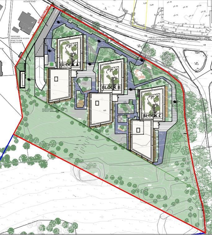
Document No.: 19.196-IR-03                                                             Page: 2 of 51

Document History
Project                  Proposed Strategic Housing Development, Kenelm, Deer Park,
Howth, Co. Dublin

Project No.              19.196

Document Title           Mobility Management Plan

Document No.             19.196 – IR – 03

  Issue       Date                  Description                Orig.            PE          Issue Check

                                                                                SO’C
 P1       21/06/2020   Issued at Pre-Application stage   Dr. M. Rogers   SO’C                 SO’C
 P2       20/05/2021   Issued for SHD Application        Dr. M. Rogers   SO’C                 DO’R

Contact Information
Barrett Mahony Consulting Engineers Ltd
52-54 Lower Sandwith Street, Dublin 2
D02 WR26

Telephone: 01 677 3200
Email: bmce@bmce.ie

www.bmce.ie
Document No.: 19.196-IR-03                                                                                                                   Page: 3 of 51

TABLE OF CONTENTS
1.0      INTRODUCTION .................................................................................................................................... 5
2.0      MOBILITY MANAGEMENT PLANS: THE POLICY CONTEXT ...................................................................... 8
  2.1    SMARTER TRAVEL, A SUSTAINABLE TRANSPORT FUTURE (STASTF) – A NEW TRANSPORT POLICY FOR IRELAND, 2009 –
  2020 8
  2.2    GREATER DUBLIN AREA TRANSPORT STRATEGY, 2016-2023 .............................................................................. 8
  2.3    FINGAL COUNTY COUNCIL DEVELOPMENT PLAN, 2017-2023 ............................................................................. 8
  2.4    MAKING MOBILITY MANAGEMENT PLANS WORK: GUIDELINES FOR NEW DEVELOPMENT - UK DEPARTMENT OF
  TRANSPORT, 2005 .................................................................................................................................................. 8
  2.5    TRAVEL PLANS – A GOOD PRACTICE GUIDE FOR DEVELOPERS - SURREY COUNTY COUNCIL, UK, 2018 ...................... 10
  2.6    STANDARD ASSESSMENT METHODOLOGY (SAM) - TRICS GOOD PRACTICE GUIDE, 2016 ...................................... 12
  2.7    TRAVEL PLANS FOR NEW RESIDENTIAL DEVELOPMENTS: INSIGHTS FROM THEORY AND PRACTICE (DE GRUYTER, 2015) 13
  2.8    GOOD PRACTICE GUIDELINES: DELIVERING TRAVEL PLANS THROUGH THE PLANNING PROCESS - DEPARTMENT FOR
  TRANSPORT UK, 2009 ........................................................................................................................................... 16
3.0      DEVELOPMENT LOCATION, LOCAL TRANSPORTATION SYSTEM AND LOCAL TRAVEL TRENDS ............. 18
  3.1   INTRODUCTION ......................................................................................................................................... 18
  3.2   DEVELOPMENT LOCATION ........................................................................................................................... 18
  3.3   EXISTING PUBLIC TRANSPORT AND CYCLING FACILITIES ....................................................................................... 19
              Existing bus facilities ..................................................................................................................... 19
              Existing cycling facilities ................................................................................................................ 20
              Access to DART.............................................................................................................................. 21
  3.4   FUTURE PLANNED PUBLIC TRANSPORT AND CYCLING FACILITIES ............................................................................ 21
              Future bus facilities ....................................................................................................................... 21
              Future cycle facilities ..................................................................................................................... 23
  3.5   BASELINE MODAL SPLITS FOR THE PROPOSED DEVELOPMENT (PRE-OCCUPATION) .................................................. 24
              Modal split for the private car – 2016 Census results for Electoral Districts in the vicinity of the
    proposed development ................................................................................................................................. 24
              Derivation of baseline modal splits ............................................................................................... 25
4.0      MOBILITY MANAGEMENT PLAN MANAGER ....................................................................................... 26
  4.1        OVERALL RESPONSIBILITIES OF MMP MANAGER ............................................................................................. 26
  4.2        CORE ACTIONS TO BE DELIVERED BY MMP MANAGER ....................................................................................... 26
5.0      MOBILITY MANAGEMENT PLAN OBJECTIVES, TARGETS AND MEASURES ........................................... 27
  5.1        INTRODUCTION ......................................................................................................................................... 27
  5.2        OBJECTIVES OF THE MMP ........................................................................................................................... 27
  5.3        TARGET MODAL SPLITS ................................................................................................................................ 27
  5.4        ASSUMPTIONS UNDERLYING THE PROPOSED MODAL SPLIT TARGETS...................................................................... 28
  5.5        MMP MEASURES...................................................................................................................................... 29
6.0      ACTION PLAN FOR IMPLEMENTATION OF MMP FOR PROPOSED DEVELOPMENT ............................... 30
  6.1        INTRODUCTION ......................................................................................................................................... 30
  6.2        ACTION PLAN MEASURES FOR PRIVATE CAR, PUBLIC TRANSPORT, WALKING AND CYCLING ...................................... 30
  6.3        ACTION PLAN MEASURES FOR MONITORING AND INSPECTION OF MMP................................................................ 32
  6.4        ACTION PLAN MEASURES FOR MARKETING AND PROMOTION OF MMP ................................................................ 33
  6.5        FORMAL METHODOLOGY FOR MONITORING TRAVEL AND TRAFFIC – THE STANDARD ASSESSMENT METHOODOLOGY (SAM)
             34
                  Introduction .................................................................................................................................. 34
                  The SAM Process ........................................................................................................................... 34
7.0      OVERALL COMMENTS ON MOBILITY MANAGEMENT PLAN ................................................................ 35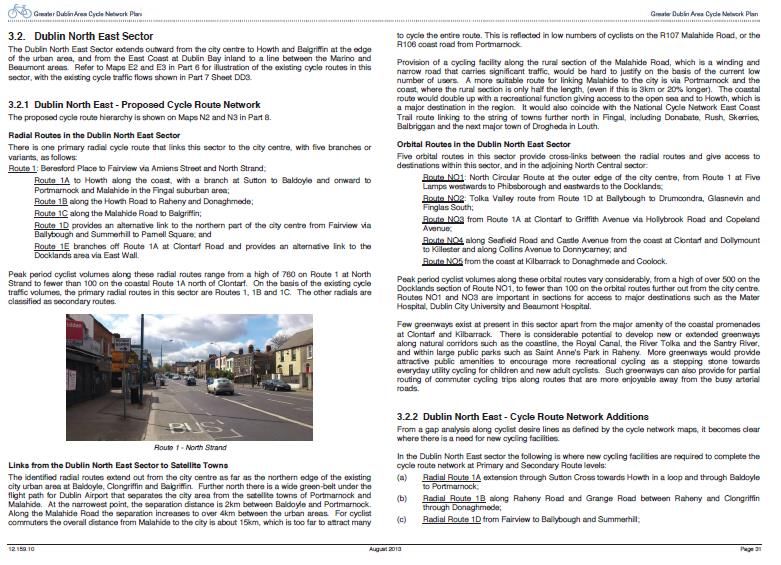
Document No.: 19.196-IR-03                              Page: 4 of 51

APPENDICES
APPENDIX 1 - SITE LAYOUT
APPENDIX 2 - TRAVEL PLAN PYRAMID
APPENDIX 3 - BUS CONNECTS - HOWTH AND NORTH EAST AREA
APPENDIX 4 - GDA CYCLE PLAN - NORTH-EAST SECTOR
APPENDIX 5 - 2016 CENSUS DATA - ELECTORAL DISTRICTS
Document No.: 19.196-IR-03                                                                          Page: 5 of 51

Barrett Mahony Consulting Engineers have been commissioned to provide a Mobility Management Plan (MMP)
for the proposed SHD at Kenelm, Deer Park, Howth, Co. Dublin.. This MMP is to be read in conjunction with the
Traffic and Transport Assessment, document 19.196-IR-04, prepared by BMCE which accompanies this SHD
application.

The proposed development will consist of 162 No. apartments, with 132 No. car parking spaces (including 6 No.
disabled, 13 No. EV spaces and 4 no. shared Go Car) and 355 No. cycle parking spaces (325 long stay & 30 short
stay).

The above provisions equate to 0.81 No. car parking spaces per unit and 2.19 No. cycle parking spaces per unit.

It will be assumed within this report that the proposed development will open in 2023.

A site layout of the proposed development is detailed within Appendix 1.

The apartment breakdown is thus as follows;
•     1-Bedroom units 29 No.
•     2-Bedroom units 104 No.
•     3-Bedroom units 29 No.

A travel plan is a document which comprises a strategy for reducing car use to a development site, combined
with a package of measures for implementing the strategy. They are required through the planning process for
a broad range of land uses, including residential, retail, employment, education, leisure and health.

In this instance, a mobility management plan (MMP) is of relevance.

Travel plans are living documents which require regular monitoring and review. The benefits of successfully
implemented travel plans include:
    • Reduced traffic congestion, demand for parking spaces and travel costs for residents; and
    •    Improved health for residents through the use of active travel and better air quality in the area around
         a development site.

A mobility management plan is thus a package of measures designed to reduce the number and length of car
trips generated by a residential development, while also supporting more sustainable forms of travel and
reducing the overall need to travel. It is concerned with journeys made from a single origin to multiple and
changing destinations. This objective raises a number of issues and explains the need for specific good practice
advice, though many aspects of good practice in developing destination travel plans are likely to apply to
Mobility Management Plans.

In order to maximise its effectiveness, it is planned to put in place an ongoing management organisation and
structure for the travel plan which will oversee the implementation of the MMP.

It is envisaged that the measures included in a mobility management plan will include demand management and
smart travel tools, as well as improvements in services and facilities. It will combine the 'soft' measures of
promotion and awareness raising with 'hard' measures and improvements to design, infrastructure and services,
both on-site and off-site. In addition, because of the many purposes of journeys from home, the mobility
management plan may need to incorporate a wider range of measures to encourage more sustainable travel
choices. It will need to be "fit for purpose" given the substantial variety of scale, location and type of residential
development.

A mobility management plan should also include targets, monitoring and management arrangements to ensure
that the objectives of the travel plan are achieved and that it remains sustainable over the longer term.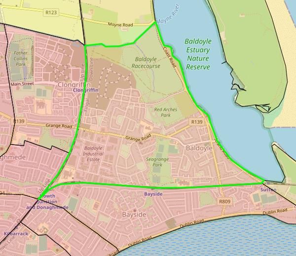
Document No.: 19.196-IR-03                                                                          Page: 6 of 51

Mobility Management Plans:
   • Are site specific - the detailed choice of measures will be partly determined by the opportunities and
         constraints offered by the site, for example, the location of existing public transport routes, health
         facilities and workplaces in the immediate area. They are therefore unique to the site and not a
         standard combination of measures.
   • Combine the ’hard measures’ - of site design, infrastructure and new services - with the ’soft measures’
         - of marketing, promotion and awareness-raising among residents.
   • Provide a holistic package in which individual measures are integrated into the design, marketing and
         occupation of the site rather than 'retrofitted' once the development is established. The measures
         should aim to achieve more sustainable travel patterns from the outset, rather than cutting car use
         incrementally once the residents are in occupation. Include measures to support walking, cycling and
         public transport use.
   • Include parking restraint. A degree of parking restraint is likely to be critical to the success of the plan
         in reducing car use. It follows that the introduction of a travel plan should never be treated as
         justification for approving more generous parking: the parking level is itself an important measure in
         the plan.

A successful MMP will thus address all aspects of a development that create a need to travel by site residents.
The MMP ‘pyramid’ below demonstrates how successful plans are built on the firm foundations of location and
site design, progressing from the fifth tier up to the first tier.

A MMP should combine hard measures such as cycle parking, pedestrian routes to bus stops, and soft measures
such as bus taster tickets and personalised journey planning. All measures should be integrated into the design,
marketing and occupation of the site – with parking restraint often crucial to the success of the MMP in reducing
car usage.

The structure of the pyramid is as follows:

First tier
Marketing, promotion,
Awareness-raising
Second tier:
Car clubs, cycle hire, parking management,
Third tier:
The appointment of a Mobility Management Plan Co-ordinator to develop further measures
Fourth tier:
Parking restraint, facilities that reduce the need to travel, including car and cycle parking
Fifth Tier:
Location of proposed development and proximity to existing facilities and services

Appendix 2 contains a diagrammatic representation of the pyramid.

The Traffic and Transport Assessment which is a standalone document within this application concentrates on
the third, fourth and fifth tier, detailing existing and proposed public transport, walking and cycling infrastructure
serving the site of the proposed development, detailing the level of car and cycle parking provided by the
proposal, deriving a day of opening set of modal splits and outlining broad measures to ensure that the derived
modal splits are met if not exceeded during the period of time after the day of opening.

This mobility management plan document will concentrate on the first, second and third tiers, detailing specific
modal split targets for the five-year period after the development opening, and detailing the active measures
taken to improve the splits for sustainable modes of travel, and methodologies for monitoring modal splits to
demonstrate the shift over time in favour of sustainable modes.

The MMP will detail an active demand management strategy to limit car usage by residents, and formal
mechanisms for measuring the impact of this strategy over time.
Document No.: 19.196-IR-03                                                                      Page: 7 of 51

The structure of the MMP for the proposed residential development at Deer Park, Howth, is as follows:

Section 2 details the policy context, providing an overview of the policy and academic drivers underpinning the
requirement to undertake and implement a MMP.

Section 3 details the environment within which the proposed residential development MMP is placed, such as
location and local transportation system, details local travel trends and 2016 census data used to establish
baseline modal splits for the subject site.

Section 4 details the centrally important issue of appointing the Mobility Management Plan Manager.

Section 5 establishes objectives, targets and measures for the MMP, detailing the measures and travel initiatives
selected within the MMP to encourage sustainable travel, including mode specific, management centred,
together with marketing measures plus monitoring & review measures.

Section 6 details an Action Plan for the MMP at the residential development at the Howth Road development.

Section 7 contains some overall conclusions and recommendations for the MMP presented for the proposed
development.
Document No.: 19.196-IR-03                                                                          Page: 8 of 51

2.1    SMARTER TRAVEL, A SUSTAINABLE TRANSPORT FUTURE (STASTF) – A NEW TRANSPORT
       POLICY FOR IRELAND, 2009 – 2020
This document plans for an integrated transport network that enables the efficient, effective and sustainable
movement of people and goods, in order to contribute to economic, social and cultural progress.

It recognises that, without intervention, congestion will get worse, transport emissions will continue to grow,
economic competitiveness will suffer, and quality of life will decline. The key goals are to improve quality of life
and accessibility to transport for all and for people with reduced mobility and those who may experience
isolation due to lack of transport; to improve economic competitiveness through maximising the efficiency of
the transport system and alleviating congestion and infrastructural bottlenecks; to minimise the negative
impacts of transport on the local and global environment through reducing localised air pollutants and
greenhouse gas emissions; to reduce overall travel demand and commuting distances travelled by the private
car and to improve security of energy supply by reducing dependency on imported fossil fuels.

Its implementation will help meet Ireland's international obligations towards tackling climate change, enhancing
existing legislative provisions to deliver deeper integration of travel and spatial planning and to support the full
integration and alignment of transport plans with the development plan process and local area planning, and
ensure better integration of land use planning and transport policies in the relevant planning guidelines as part
of their ongoing review and we will avail of policy directives to give effect to specific measures needed to meet
the vision for sustainable travel.

It details a requirement that developments above a certain scale have viable travel plans in place, that significant
housing development in all cities and towns must have good public transport connections and safe routes for
walking and cycling to access such connections and local amenities, and the necessity for the integration of
cycling and public transport with the proposal.

2.2    GREATER DUBLIN AREA TRANSPORT STRATEGY, 2016-2023
The Greater Dublin Area (GDA) Transport Strategy has, as its central objective, the promotion of efficient,
effective and sustainable movement of people and goods, thereby helping to reduce modal share of car-based
commuting to a maximum of 45%. To achieve these principles, future developments must have transport as a
key consideration in land use planning – integration of land use and transport to reduce the need to travel,
reduce the distance travelled, reduce the time taken to travel, promote walking and cycling especially within
development plans, protect the capacity of the strategic road network, ensure a significant reduction in share
of trips taken by car, especially those trips which are shorter or commuter trips, and provide alternate transport
modes in order to reduce the strain on the M50 as current increase in traffic is unsustainable.

The mobility management plan demonstrates the proximity of the site to improved public transport provisions,
such as the proposed BusConnects Core Bus Corridor, which will improve overall levels of public transport
provision within the GDA, improving public transport options for residents.

2.3    FINGAL COUNTY COUNCIL DEVELOPMENT PLAN, 2017-2023
Mobility Management Plans are seen within this document as effective instruments to promote the provision of
sustainable travel infrastructure within a development. MMP’s are applicable to housing developments,
workplaces, colleges, schools and hospitals as Travel Plan initiatives relate not only to residents but also to staff,
students or visitors.

2.4    MAKING MOBILITY MANAGEMENT PLANS WORK: GUIDELINES FOR NEW DEVELOPMENT -
       UK DEPARTMENT OF TRANSPORT, 2005
This document details the policy context of an MMP, exploring the benefits they can offer and sets the context
in terms of related policy issues, outlines MMP design and content, including objectives and guiding principles,
and the measures that can be secured as part of a mobility management plan. It details the process of requiring
a mobility management plan, covering the key stages in the mobility management planning process, the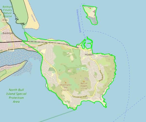
Document No.: 19.196-IR-03                                                                         Page: 9 of 51

management, monitoring and enforcement of the MMP, highlighting key issues to be taken into account to
ensure that the travel plan is effective and continues to be effective. It also details a strategic framework which
reviews the planning and transport framework underpinning an effective mobility management plan;

The guidance within this document is used extensively within the MMP for the proposed development. It stated
that travel planning had, to date, largely focussed on the development of destination travel plans, which are
generally designed to reduce car use to a specific destination - such as a workplace, school or a visitor attraction.
Within such a plan, the office employer, the school or the attraction itself, in partnership with others such as the
planning authority and public transport operators, destination travel plans focus mainly on a particular journey
purpose, e.g. the journey to work, school, etc.

The document states that, in contrast, a mobility management plan is concerned with journeys made from a
single origin multiple and changing destinations. This crucial difference raises a number of issues and explains
the need for specific good practice advice, though many aspects of good practice in developing destination travel
plans are likely to apply to mobility management plans.

It states that key differences between the origin-based mobility management plans and destination office /
school travel plans are:
     • The pattern of journeys originating at home is more varied, with residents having multiple destinations
          and different needs and travel choices over time. This is a crucial difference compared with destination-
          based plans which normally only deal with a single journey purpose e.g. access to work.;
     • An ongoing management organisation and structure for the travel plan needs to be put in place, as
          there is often no single company or institution to provide continuity and a common point of interest
          for residents

This guidance document looks at mobility management plans in the context of new development, where the
travel plan will normally be drawn up before the residents are in occupation. It is envisaged that the measures
included in a mobility management plan will include demand management and smart travel tools, as well as
improvements in services and facilities. As with destination travel plans, it would generally combine the 'soft'
measures of promotion and awareness raising with 'hard' measures and improvements to design, infrastructure
and services, both on-site and off-site. In addition, because of the many purposes of journeys from home, the
mobility management plan may need to incorporate a wider range of measures to encourage more sustainable
travel choices. It will need to be "fit for purpose" given the substantial variety of scale, location and type of
residential development.

A mobility management plan should also include targets, monitoring and management arrangements to ensure
that the objectives of the travel plan are achieved and that it remains sustainable over the longer term. It should
be secured through the planning system as part of the assessment of the planning application. As with other
travel plans, mobility management plans should be a key requirement on a par with highways improvements or
instead of them for any residential development likely to generate significant levels of traffic. They should not,
of course, be a reason for approving an unacceptable development in the wrong location but, where practical,
providing a means of solving accessibility issues.

Travel planning for residential development is stated to have the potential to help achieve more sustainable
communities by improving their accessibility. New housing development is normally characterised by high car
trip generation. However, better choices about the location and density of new housing, combined with the
increased use of mobility management plans, should deliver a real impact on travel patterns and aid progress
towards sustainable transport and land use objectives.

If the travel plan is designed into the residential development from the beginning and supported by a long-term
commitment and mechanisms for implementation, potential local benefits.
     • Reducing the need for car use with benefits in terms of reduced traffic, congestion, air pollution and
          accidents;
     • Improving accessibility and travel choice for reaching local facilities;
     • Improving public transport provision for people in nearby developments because of the increased
          economies of scale;
Document No.: 19.196-IR-03                                                                         Page: 10 of 51

      •    Increasing scope for child-friendly housing layouts with fewer roads, vehicle movements and parking
           areas; complementing nearby travel plans, and possibly even assisting them in achieving more
           ambitious initiatives;
      •    Improving access by the wider community to the residential development by sustainable modes of
           transport;
      •    Representing good practice and providing an educational tool to help change perceptions about the
           convenience and benefits of not using the car where alternatives exist;
      •    Achieving more attractive environments that contribute to regeneration and renewal initiatives;
      •    Increasing marketability of the development as more households seek to change their travel
           behaviour.

The document thus clearly illustrates the benefits of a well thought out Mobility Management Plan to
achieving more environmentally sustainable communities.

2.5       TRAVEL PLANS – A GOOD PRACTICE GUIDE FOR DEVELOPERS - SURREY COUNTY COUNCIL,
          UK, 2018
This document is central to the process of defining the content of a mobility management plan and setting
appropriate targets and measures to achieve these targets.
Content
All development related travel plans must describe the following:
     • The proposed development, location and associated transport links
     • The approximate number of residents expected to inhabit the development
      •    Likely future travel facilities at the site
      •    Details of proposed facilities which will encourage the take-up of sustainable travel, for example, the
           number of parking spaces, cycle storage spaces, washing and changing amenities, lockers etc.
      •    Details of the travel plan coordinator’s role
      •    Objectives, which should comprise a list of intended outcomes
      •    SMART modal share targets, which link to the objectives, set over a 5-year time horizon (specific,
           measurable, attainable, realistic and time bound)
      •    Measures, which aim to achieve the targets
      •    An action plan, each measure to have a completion date and to state who will be responsible for
           implementation
      •    A list of remedial measures, for implementation if targets are not achieved by Year 3
      •    How the travel plan will be monitored?
Targets
The document details indicators which allow a travel plan’s progress to be measured. They put a value on a
travel plan’s objectives. They should be:
    • Linked directly to the objectives of the travel plan;
    • Set over a minimum of five years, with interim targets at year one and year three;
    • SMART (specific, measurable, attainable, realistic and time bound). An example would be to reduce
          single occupancy vehicle trips by x% by x date;
    • Clear about which journeys are being assessed (all trips/peak trips only). Residential developments
          should focus on weekdays, peak hours only; and
    • Focused on reducing the amount of single occupied vehicles generated by the development.

The document details how MMP targets should be typically expressed (see Table 2-1):
Document No.: 19.196-IR-03 Page: 11 of 51
Target Baseline 2018 2020 2022
(year1) (year 3) (year 5)
Reduce the proportion of residents travelling 67% 64% 60% 57%
between 8.00-9.00am and 5.00-6.00pm on
weekdays in single occupied vehicles.
Increase proportion of lift sharers during peak hours 8% 9% 10% 11%
Increase the proportion of public transport users 13% 14% 15% 16%
during peak hours
Increase proportion of cyclists during peak hours 3% 4% 5% 5%
Increase proportion pedestrians during peak hours 9% 9% 10% 11%
Table 2-1: Example of typical targets contained within document relating to a residential development
Measures / Action Plan
The document notes that measures are introduced to achieve the targets set out in the travel plan and should
be tailored to the specific requirements of the site.
When describing proposed measures, the document notes that developers should note the following:
Measures should contribute to achieving the targets and objectives
• Measures should contribute to achieving the targets and objectives
• Only known measures should be included (suggested measures for the occupier to implement should
not be included, unless the developer can ensure that they will be implemented by the occupier)
• Infrastructure and facilities, both existing and proposed, should be included (for example, changing
facilities, pedestrian/cycle routes through a development and the number of lockers, showers and cycle
parking spaces)
• Similarly, details of “soft” measures, such as travel noticeboards, should also be described
An action plan should be included, setting out measures to be implemented along with corresponding timescales
and responsibilities. The action plan should differentiate between measures to be implemented by the
developer and those to be implemented by the occupier.
The proposed structure (content, targets, measures/ action plan) as outlined within the 2018 Guide to Good
Practice will form the basis for the structure of the Travel Plan for the proposed development at Howth Road.Document No.: 19.196-IR-03 Page: 12 of 51 2.6 STANDARD ASSESSMENT METHODOLOGY (SAM) - TRICS GOOD PRACTICE GUIDE, 2016 The TRICS database is the UK and Ireland’s national system of trip generation analysis, containing over 7150 directional transport surveys at over 110 types of development. TRICS was founded and is owned by 6 County Councils in the south of England, collectively the TRICS® Consortium. However, its annual collection programme covers the whole of the UK and Ireland, across 17 defined regions. The TRICS Consortium operate the TRICS Database which is a very powerful and flexible system for calculating both vehicular and multi-modal trip rates. The TRICS Consortium operate the Standard Assessment Methodology, which allows their surveying system to be utilised to monitor the progress of a mobility management plan. SAM provides a system within which formal traffic surveys which monitor the progress of the mobility management plan through to year 5. In 2005 TRICS introduced a national standard methodology for assessing the effect of travel plans, known as SAM. It is designed to monitor the influence of travel plans on trip generation and mode choice behaviour. A number of UK local authorities have introduced the need for SAM surveys into planning agreements for new developments, so that travel plan targets can be measured against actual trip activity. For this purpose, a “Travel Plan” data section has been introduced into TRICS, which contains comprehensive information on a site’s travel plan measures, dates of their implementation, and their costs. As shown in Figure 30 below, surveys undertaken for the SAM project can be easily identified within the database. By using the “Additional Columns” feature at the top of the screen the user can select the “SAM” category to be displayed. Surveys with Travel Plan data sections within them are known as Level 3 Surveys, with traffic surveys being Level 1 and standard multi-modal surveys being Level 2. Many of the Local Highway Authorities within the South East of England and London recommend that TRICS Level 3 surveys are undertaken to monitor the effectiveness of travel plans, including mobility management plans. They also often recommend that the surveys are undertaken in years 1, 3 and 5 of the operation of the site’s travel plan, as a minimum. This enables sufficient monitoring over time, including the effect evident by changes in the travel plan over this period. It is highly recommended that SAM surveys are undertaken using TRICS-approved data collection contractors, with the surveys project-managed by the TRICS team. As all SAM surveys are undertaken to the standard TRICS data collection methodology, they are fully compatible for inclusion in standard TRICS trip rate calculations, subject of course to the usual criteria for selection. There is no fundamental reason why any sites highlighted as SAM should be excluded from selected sets for calculation. As with all types of survey, there may be factors external to a site’s travel plan that influence trip rates. For example, these can include weather and economic conditions. Users should not claim that a specific element of a site’s travel plan has directly influenced trip activity, unless this can be independently proven to be the case. If providing trip rate generation data from an individual SAM site, it is good practice to include the Travel Plan data section in reports, as this will provide the data recipient with additional, descriptive information about the organisation of the site’s travel plan. In December 2012 a new feature, the Travel Plan Monitoring Report (TPMR) Generator, was made available to all users. This facility allows users to generate a report that provides a summary of trip generation and modal split, along with travel plan measures, for any individual site surveyed with a Travel Plan data section. This is a very handy facility for monitoring the effect of individual development travel plans. Users are encouraged to present TPMR reports in line with the Good Practice Guide, in that they should explain to recipients of reports
Document No.: 19.196-IR-03                                                                     Page: 13 of 51

what is being presented in a clear manner, providing additional commentary should this be requested by report
recipients.

SAM has the potential to provide significant support to the monitoring process at the proposed Howth Road
development.

2.7    TRAVEL PLANS FOR NEW RESIDENTIAL DEVELOPMENTS: INSIGHTS FROM THEORY AND
       PRACTICE (DE GRUYTER, 2015)
This document aims to assess the effectiveness of travel plans for new residential developments and to identify
opportunities to enhance their effectiveness. A mixed methods approach comprising five key research areas is
adopted to achieve this aim, including the application and integration of both implementation theory and
planning enforcement theory.

It summarises the travel planning process in five steps as detailed within Figure 2-1 below:

Figure 2-1: Travel Plan Process (De Gruyter, 2015)
Document No.: 19.196-IR-03 Page: 14 of 51
Steps 3, 4 and 5 are seen as central to the process, and are the focus of this report.
Generally, De Gruyter notes that all international research recommends that the following seven elements are
included within Step 3 which is central to the success of the MMP process:
• Context – site location, number of units and occupants
• Existing transport conditions – existing transport network
• Objectives – what travel plan aims to achieve
• Targets and indicators – developed to support the achievement of the objectives
• Actions and measures – covering all modes of transport
• Management – timeframes, roles and responsibilities
• Monitoring and review – frequency, methods and timing of these components
De Gruyter’s deliberations on the significant issues with Steps 3, 4 and 5 of the MMP process are summarised
within Table 2-2:
STAGE KEY ISSUES
DEVELOPING THE MOBILITY PLAN (STAGE 3) • Developers pay ‘lip-service’ to the concept, particularly
when the travel plan is only prepared to seek planning
approval
• Lack of travel planning guidance specifically for new
developments in some jurisdictions
• Varying quality of travel plans being submitted and
approved, particularly where planning assessment
officers lack sufficient knowledge or experience with
travel plans
• Travel plan considered too late in the land use planning
process
• Nature of proposed development is sometimes unknown,
despite this information being vital to informing the
objectives, targets and measures in a travel plan
IMPLEMENTING THE MOBILITY PLAN (STAGE • General lack of implementation of travel plan measures
4) and associated follow-up
• Lack of suitable handover arrangements from the
developer to tenant or property manager
• Inconsistency between the objectives of the travel plan
and motivations of those responsible for implementing
the travel plan
• Uncertainty over roles and responsibilities
• Lack of ownership of the travel plan
MONITORING THE MOBILITY PLAN (STAGE 5) • General lack of monitoring, leading to a lack of evidence
of travel plan effectiveness
• Insufficient resources within local government to
undertake effective enforcement
• Uncertainty in use of legal mechanisms for enforcing
travel plans
• Uncertainty over roles and responsibilities
Table 2-2: Key issues in requiring travel plans for new developments (De Gruyter, 2015)
The document also details common methods for measuring the effectiveness of travel plans. The main methods
are listed below within Table 2-3:Document No.: 19.196-IR-03 Page: 15 of 51
NO. METHOD STRENGTHS LIMITATIONS
Can help to determine transport Response rates vary; needs to be
Travel survey
1 modal split, awareness of travel conducted regularly or compared to
questionnaire
plan measures and other indicators secondary data or control sites
Limited to small groups and generally
Can explore impacts of the travel
2 Focus groups only provides qualitative information;
plan in depth with users of the site
can be labour intensive
Can be labour intensive; needs to be
Provides an independent measure conducted regularly or compared to
3 Vehicle counts
of car use at the site secondary data or control sites to
measure effectiveness
Can be labour intensive; needs to be
Provides an independent measure conducted regularly or compared to
4 Multi-modal counts
of transport modal split secondary data or control sites to
measure effectiveness
Determines utilization of car Needs to be conducted regularly or
5 Car parking counts parking at site and can help to compared to control sites to measure
inform future travel plan measures effectiveness
Determines utilization of bicycle Needs to be conducted regularly or
Bicycle parking
6 parking at site and can help to compared to other sites to measure
counts
inform future travel plan measures effectiveness
Table 2-3: Common methods used to evaluate the effectiveness of Travel Plans
The document lists a range of success factors for maximising travel plan effectiveness, including:
• Building ownership and engagement in the travel planning process (Howlett & Watson 2010)
• Securing senior management support (Baudains 2003)
• Having an enthusiastic and dedicated travel plan coordinator (Van Malderen et al. 2013)
• Implementing a set of comprehensive travel plan measures (Ison & Rye 2008)
• Incorporating constraints on car parking (Cairns et al. 2010)
• Having a supportive policy framework in place (Addison & Associates 2008).
The document notes that car parking constraints have also been cited widely in the literature as a key success
factor for travel plans. Results of around 20 case studies in the United Kingdom demonstrated that
developments that had addressed parking achieved more than double the reduction in car use of those that had
not.
As a result, car parking restraint will form a central part of the MMP Strategy for the proposed development at
Deer Park, Howth Road, Co. Dublin.Document No.: 19.196-IR-03 Page: 16 of 51
2.8 GOOD PRACTICE GUIDELINES: DELIVERING TRAVEL PLANS THROUGH THE PLANNING
PROCESS - DEPARTMENT FOR TRANSPORT UK, 2009
This document focusses on the way in which planning and travel plans currently interrelate and how this could
be made more effective.
The document states can be helpful to view a travel plan for a new development as a pyramid of measures and
actions as detailed within Appendix 2, which is constructed from the ground up, with each new layer building on
the last all set within the context of the outcomes sought.
The coverage of all levels of the pyramid will maximise the effectiveness of the finished document.
It states that clarity from the outset regarding the objectives being sought through the travel plan and the
outcomes related to them for a particular development proposal is of central importance.
These required outcomes will drive the form and content of the travel plan, including the targets chosen and
indicators in relation to them.
The design and content of Travel Plans should be guided by the requirement to meet the following objectives
and outcomes:
• Achieving the minimum number of additional single occupancy car traffic movements to and from the
development;
• Reducing the need for travel to and from the site;
• Addressing the access needs of site users, by supporting walking, cycling and public transport;
• providing adequately for those with mobility difficulties;
• Promoting healthy lifestyles and sustainable, vibrant communities;
• Encouraging good urban design principles that open up the permeability of the site to walking and
cycling, linked to the design and access statements;
• Addressing specific problems identified in the site’s transport assessment – for example, a local road
safety problem that affects walking or cycling links to a bus or rail station;
• Encouraging access solutions that are not dependant on ‘hard’ measures;
• Being a part of the wider local approach to demand management and behavioural change.
• Reducing vehicle traffic from new development has many positive effects, for example: reducing
pressure on highway capacity, particularly at peak times;
• Creating more attractive and liveable neighbourhoods;
• Cutting carbon emissions and their contribution to climate change;
• Reducing road danger and protecting vulnerable road users;
• Reducing the cost of works on the highway or other transport infrastructure;
• Encouraging more active travel with gains for health;
• Enabling children to travel independently;
• Improving local air quality;
• Reducing noise pollution;
• Reducing parking/fleet management costs; and
• Improving staff morale.
The document adopts the ‘outcomes’ approach, where specifies outcomes linked to specific targets are utilised
that can also be strengthened with sanctions if these are not met. This approach is distinct from one which
focuses entirely on the establishment of a list of measures, e.g. the provision of a shuttle bus or cycle shelter.
It states that the majority of, travel plans combine the two approaches, depending upon the type of travel plan
and what it is designed to achieve. However, the establishment of outcomes is important.
It states that it can be helpful to view a travel plan for a new development as a pyramid of measures and actions,
which is constructed from the ground up, with each new layer building on the last and all set within the context
of the outcomes sought.Document No.: 19.196-IR-03 Page: 17 of 51 The outcomes should be established at the scoping stage, with the uses proposed for the site affecting the specific detail to be covered at the different levels of the pyramid. Specifically in relation to mobility management plans, these focus on travel by residents in housing developments. They are different from ‘destination’ travel plans in that they are designed to encourage more sustainable travel from the origin of journeys and across the full range of journey purposes. It states that mobility management plans place a strong emphasis on the choice of location and on the design of the development to reduce the need to travel. This can be achieved through the provision of local facilities and by ensuring high levels of connectivity with good public transport. Mobility Management plans may also incorporate customised travel advice and incentives to help individual households travel more sustainably, as well as car clubs and improved public transport. Travel awareness is integrated into the marketing and occupation of the site.
Document No.: 19.196-IR-03 Page: 18 of 51
3.1 INTRODUCTION
This section summarises the baseline information generally contained within a Mobility Management Plan,
forming the information for bottom tiers 4 and 5 as detailed within the Travel Plan Pyramid in Appendix 2 and
Stages 1 and 2 of the Travel Plan Process as detailed within Figure 2-1 above (audit of existing conditions, and
baseline travel data.
3.2 DEVELOPMENT LOCATION
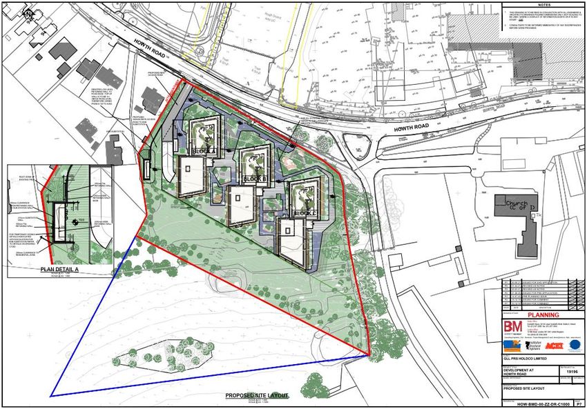
The site is located immediately north of Howth Road adjacent to the entrance to Howth Castle.
A site location map is contained within Figure 3-1 below. A site layout is contained within Figure 3-2.
SITE
Figure 3-1: Site location mapDocument No.: 19.196-IR-03 Page: 19 of 51
Figure 3-2: Site layout
The development will consist of the construction of 162 No. apartments (29 No. 1-bed, 104 No. 2 bed and 29
No. 3-bed). It is proposed to provide 132 No. car parking spaces (including 6 No. disabled spaces, 13 EV parking
spaces and 4 No. GoCar spaces) and 355 No. cycle parking spaces (325 long stay and 30 short stay). There is a
vehicular access road to the north west of the site and a pedestrian/cycle access point from the public footpath
to the north of Block B.
3.3 EXISTING PUBLIC TRANSPORT AND CYCLING FACILITIES
EXISTING BUS FACILITIES
The Dublin Bus services in the area provide direct linkage to the city, the Route 31/a along Howth Road towards
the city centre, and the 31b Route along Carrickbrack Road towards the city centre.
The frequency of each route during the morning peak is detailed within Table 3-1.
AM peak hour
Route Origin Destination
Frequency
Howth Road /
Route 31/a Talbot Street 2 per hour
Carrickbrack Road
Route 31b Carrickbrack Road Talbot Street 1 per hour
Table 3-1: Existing bus services
Figure 3-3 details the existing bus services running close to the site.Document No.: 19.196-IR-03 Page: 20 of 51
SITE
Figure 3-3: Existing bus services (31 31a) close to subject site
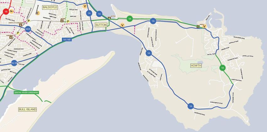
EXISTING CYCLING FACILITIES
The “Cycle Network Plan for the Greater Dublin” area has produced an overall plan for providing safe cycle routes
both within the city and in the suburbs.
Figure 3-4 contains the map of existing cycle facilities for the area close to the subject site as detailed within the
GDA Cycle Plan.
Figure 3-4: Existing cycle facilities close to the Howth Road site (GDA cycle plan)Document No.: 19.196-IR-03 Page: 21 of 51
At present, the major cycle lane is along the bus corridor on the Howth Road, linking the site to Sutton Cross and
onward toward the city centre.
ACCESS TO DART
The DART extends along the coastline of the South Dublin area, extending from the centre of town to Ballsbridge,
Sandymount, Merrion, Booterstown, Blackrock, Monkstown, Dun Laoghaire, Dalkey, Ballybrack, Shankhill, Bray
and Greystones, and along the coastline of the north Dublin area extending from the town centre to Clontarf,
Sutton, Howth and Malahide.
The Howth DART Station is within 450 metres (5 minutes’ walk) of the subject site.
The DART operates a service to the city centre every 10 to 15 minutes during the morning peak time.
Figure 3-5 contains diagrammatic representations of the DART system serving the site and its connectivity to the
regional / national rail network.
Figure 3-5: Diagrammatic representation of DART line and its connectivity to regional / national rail network
3.4 FUTURE PLANNED PUBLIC TRANSPORT AND CYCLING FACILITIES
FUTURE BUS FACILITIES
Future bus plans involve the “Dublin Area Bus Network Redesign” (Bus Connects) which is proposed to overhaul
the current bus system in the Dublin region by developing new bus corridors, new bus routes, increasing services
and new buses. The proposed Bus Connects plan for Howth is detailed within Appendix 3.
Figures 3-6 provides an overview of the overall provision of services which will upgrade the current Dublin bus
service.Document No.: 19.196-IR-03 Page: 22 of 51 Given the existence of the DART service, Bus Connects proposes the N6 orbital route across the north side of Howth, opening up a new service to DCU while maintaining a good connection to the rail or the D spine for travel to the city centre. On the southern and western sides of Howth, where demand is relatively low, local routes 290 and 291 will operate an hourly service, providing direct service to Sutton and Clongriffin DART Stations. Figure 3-6– Bus Connects Extract – proposed network
Document No.: 19.196-IR-03                                                                    Page: 23 of 51

         FUTURE CYCLE FACILITIES
Figure 3-7 details the network improvements proposed within the GDA cycle plan.

Figure 3-7: Proposed cycle facilities close to the Howth Road site (GDA cycle plan)
A secondary cycle route is planned along Howth Road . Carrickbrack Road, which will connect the subject site to
all parts of Howth, southwards towards the city centre and north-westwards towards Portmarnock, Malahide
and Swords.
In addition, the proposed East Coast Greenway will run on the northern edge of the site, connecting Howth to
the greenway network in the Greater Dublin area.

Figure 3-8 contains a drawing of the Dublin Greenway network map, indicating the extent of the east Coast
Greenway.

                                                                                                 SITE

Figure 3-8: Dublin Greenway Map, including route of East Coast Greenway
Document No.: 19.196-IR-03 Page: 24 of 51
See Appendix 4 for details of the GDA Cycle Plan for the Howth area
3.5 BASELINE MODAL SPLITS FOR THE PROPOSED DEVELOPMENT (PRE-OCCUPATION)
MODAL SPLIT FOR THE PRIVATE CAR – 2016 CENSUS RESULTS FOR ELECTORAL DISTRICTS IN THE
VICINITY OF THE PROPOSED DEVELOPMENT
Figure 3-9 contains a map detailing the 3 No. districts close to the subject site:
1. Howth (ED containing the proposed development)
2. Sutton
3. Baldoyle
3
2
1
Figure 3-9: Electoral Districts in proximity to proposed development
Table 3-2 contains the modal splits for car, bus and DART / Rail travel for the 3 No. Electoral Districts close to the
subject site.
CAR CAR
BUS DART/TRAIN CYCLING WALKING NOT STATED / WORK
Mode DRIVER PASSENGER
(%) (%) (%) (%) AT HOME / ETC.
(%) (%)
Howth 54 2 4 20 2 5 13
Sutton 47 2 4 29 5 3 10
Baldoyle 48 2 5 26 4 4 11
Average 50 2 4 25 4 4 11
Table 3-2: Modal splits for electoral districts in vicinity of subject site
Thus, for the existing inhabitants in 3 No. Electoral Districts close to the subject site, 50% commute by private
car as detailed within the 2016 Census, with 25% commuting by bus, train or LUAS and 8% cycling or walking,
and 11% not stated / working at home / etc.Document No.: 19.196-IR-03 Page: 25 of 51
DERIVATION OF BASELINE MODAL SPLITS
If one were to exclude not stated / stay at home / etc, the following modal splits can be derived which will
constitute the day-of-opening targets for the proposed residential development:
Car drivers: 57%
Car passengers: 2%
DART/Train users: 28%
Pedestrians: 4%
Bus users: 5%
Cyclists: 4%
These figures from the Electoral Districts are critical in that they demonstrate that providing car parking for 81%
of occupants of the proposed development is entirely sustainable, given that the 2016 census indicates a modal
split for car driver usage for the journey to work in the general area of 60%.
Also, it would be reasonable to assume that improving access to the bus, DART, and cycle links from the subject
site, as proposed within this report, will result in increased usage of public transport and soft modes, presently
at 33% and 8% respectively for the Electoral Districts close to the subject site, and a consequent decrease in the
use of the private car for the journey to work.
See Appendix 5 for details of the 2016 Census data used within this analysis.Document No.: 19.196-IR-03 Page: 26 of 51
4.1 OVERALL RESPONSIBILITIES OF MMP MANAGER
A MMP Manager will be appointed, and their role is to manage the implementation of the Mobility Management
Plan for the proposed residential development.
The role involves being the main point of contact for travel information, promotion and improvements. This may
also be organised in the form of a resident’s group once the development is fully occupied and operational. The
remit of the MMP Manager includes the following:
• To develop and oversee the implementation of the initiatives outlined in the MMP Action Plan below.
• To monitor the progress of the plan, including carrying out annual Mobility Management Surveys.
• To actively market and promote the social, economic and environmental benefits of sustainable travel
to residents.
• To provide sustainable travel information, support and advice to residents including: available bus
service timetables, walking and cycling maps, car-sharing, the site’s car club and cycle hire services, and
local cycling and walking schemes and events.
The MMP manager will maintain an active presence on site and will be responsible for overseeing the
implementation of the targets for the MMP set out below, and overseeing the monitoring of those targets to
ensure that they have been met, taking appropriate actions where it becomes clear they are not being
achieved.
4.2 CORE ACTIONS TO BE DELIVERED BY MMP MANAGER
The MMP manager should address the following core actions when appointed:
• Consult with key stakeholders (Planning Authority, State Bodies, etc.), to develop, implement, monitor,
evaluate and review the progress of the MMP in the achievement of stated targets / objectives;
• Oversee the completion of travel and traffic surveys / questionnaires at regular intervals after the
development becomes operational and reviewing / updating target modal splits as required over a 5-
year time horizon after the development becomes operational.
• Oversee the development of a website for the residential development which includes information on
all travel options from the site available to all residents (before site is occupied);
• Actively facilitate and encourage greater use of sustainable transport modes (walking, cycling, public
transport) in preference to the use of the private car;
• Achieve an awareness among residents of the proposed development of the MMP, its aims, objectives
and targets;
• Actively support the proposed development as a sustainable environment in transportation terms;
• Actively promote the use of sustainable modes of travel, detailing their advantages in terms of cost,
health benefits and environmental enhancements such as air quality improvements resulting from
reductions in traffic congestion.Document No.: 19.196-IR-03 Page: 27 of 51
5.1 INTRODUCTION
In order to measure the ongoing success of the Mobility Management Plan (MMP) and its various measures it is
important that a series of objectives are set in conjunction to a range of associated targets.
The achievement of stated objectives signifies an endpoint to a plan. Targets are quantifiable signposts to the
meeting of the stated objectives.
Measures can then be put in place which actively achieve the targets set out within the MMP.
The proposed objectives, targets and measures are set out in this section of the MMP, allowing us to complete
tier 3 of the MMP Pyramid, which involves the appointment of an MMP coordinator, whose function is to
establish targets, develop measures to achieve them and monitors progress of plan in achieving targets on an
ongoing basis.
5.2 OBJECTIVES OF THE MMP
Within the MMP, objectives are set in order to minimise the modal split for single occupancy car trips and
maximise the use of sustainable modes of transport for residents at the site.
To achieve this overall objective, a number of contributing proxy objectives must be met:
• Actively encourage the most efficient use of cars and other vehicles;
• Maximise the awareness of residents of the sustainable transport options available to them;
• Actively encouraging people to walk, cycle, use public transport or utilise available car club facilities
• Actively promote walking and cycling as a health benefit to residents;
• Pro-actively manage the ongoing development and delivery of the MMP with residents;
• Actively promote smarter working, living practices that reduce the need to travel overall, and healthy
lifestyles within sustainable, vibrant local communities.
The objectives can be summarised as follows:
• Advocate good urban design by maximising the permeability of the development to nearby areas and
providing pedestrian and cycling facilities.
• Take into consideration the requirements of residents in relation to accessing facilities for employment,
education, health, leisure, recreation and shopping purposes, including identifying local amenities
available that reduce the need to travel longer distances;
• Minimise the vehicular traffic generated by the development to a lower level of car trips than that
predicted both within the Census information and the Traffic and Transport Assessment – including
developing measures to reduce the need to travel, such as the provision of ancillary facilities
5.3 TARGET MODAL SPLITS
Targets put a value on a travel plan’s objectives. They should be, linked directly to the objectives of the travel
plan, set over a minimum of five years, with interim targets at year one and year three, and they should be
specific, measurable, attainable, realistic, and time bound, consistent with the minimization of single occupancy
car trips and the maximization of the use of sustainable modes.
The pre-occupation modal splits are derived on the basis of the Census data as presented within Section 3 above.
They will be modified, once the development opens, to take into consideration the 4 No. car club spaces in place
on the development’s day of opening.
It will be necessary to collect data to identify and understand the Post-Occupation baseline and ongoing travel
habits, against which the MMP’s progress can be measured. It is recommended that residents’ travel surveys
are undertaken within 1, 2 and 5 years after the day of opening. These travel surveys will establish the Post-You can also read