Kings Oak Primary School Kings Oak Primary Framework School Travel Plan - Royal Borough of Kingston
←
→
Page content transcription
If your browser does not render page correctly, please read the page content below

Kings Oak Primary School
Kings Oak Primary Framework
School Travel Plan
Royal Borough of Kingston
December 2013
Kings Oak Primary School
Kings Oak Primary Framework School Travel Plan

Notice
This document and its contents have been prepared and are intended solely for Royal Borough of Kingston’s
information and use in relation to Kings Oak Primary School.

Atkins Highways & Transportation assumes no responsibility to any other party in respect of or arising out of
or in connection with this document and/or its contents.

This document has 44 pages including the cover.

Document history
Job number:                                             Document ref:
Revision    Purpose description         Originated      Checked        Reviewed       Authorised   Date
Rev 1.0     First Draft                 RT              RT/TO          TO             SS           04/12/13

Client signoff
Client                Royal Borough of Kingston

Project               Kings Oak Primary School

Document title        Kings Oak Primary Framework School Travel Plan

Job no.

Copy no.

Document
reference

Atkins Kings Oak Primary Framework School Travel Plan | Version 1.0 | December 2013
Kings Oak Primary School
Kings Oak Primary Framework School Travel Plan

Table of contents
Chapter                                                                                   Pages
1.      Introducing our School                                                                5
1.1.    Introduction                                                                          5
1.2.    What is a Travel Plan?                                                                5
1.3.    School Information & Operation                                                        5
1.4.    Proposed Expansion                                                                    5
2.      Policy Review                                                                         6
2.1.    National Planning Policy Framework                                                    6
2.2.    Regional Policy                                                                       7
2.3.    Local Policy                                                                          8
2.4.    Summary                                                                              11
3.      Site Assessment                                                                      12
3.1.    Location of the School                                                               12
3.2.    Surrounding Road Network                                                             14
3.3.    Access Arrangements                                                                  25
3.4.    Road Safety                                                                          25
4.      Existing Travel Patterns                                                             30
4.1.    Existing Mode Split                                                                  30
4.2.    Geographical Locations of Staff and Pupils                                           30
4.3.    Existing Travel Issues                                                               33
5.      Future Travel Patterns                                                               34
5.1.    Future Additional Trips                                                              34
5.2.    Proposed Travel Issues                                                               35
6.      Aims, Objectives and Targets                                                         36
6.2.    Provisional Targets                                                                  36
7.      Travel Plan Measures & Initiatives                                                   38
7.1.    Initiatives                                                                          38
7.2.    Measures                                                                             38
8.      Monitoring and Review                                                                40
8.1.    Travel Surveys                                                                       40
8.2.    Action Plan                                                                          41
9.      Delivering the Travel Plan                                                           42
10.     Sign off and Formal Approval                                                         43
10.1.   School Signatures                                                                    43

Tables
Table 3-2      Three Year Accident Summary                                                   26
Table 4–1      Existing Pupil Trips and Mode Share for Kings Oak Primary School              30
Table 4–2      Existing Staff Trips and Mode Share for Kings Oak Primary School              30
Table 4-3      Home to School Distance                                                       31
Table 4-4      Existing Travel Issues                                                        33
Table 5–1      Additional Trips Related to the Full Expansion                                34
Table 5-2      Existing and Potential Additional Travel Issues and Potential Mitigation      35
Table 6–1      Existing and Suggested Mode Share                                             37
Table 7–1      Travel Plan Initiatives for Pupils                                            38
Table 7–2      Travel Plan Initiatives for Staff                                             39
Table 8–1      Proposed Programme for Implementation                                         41

Atkins Kings Oak Primary Framework School Travel Plan | Version 1.0 | December 2013
Kings Oak Primary School
Kings Oak Primary Framework School Travel Plan

Figures
Figure 1-1   Site Location ............................................................................................................................ 13
Figure 3-2   Surrounding Road Network ..................................................................................................... 14
Figure 3-3   A2043 Kingston Road Pelican Crossing .................................................................................. 15
Figure 3-4   Speed Table and 20mph Speed Limit enforced along Dickerage Lane at the junction with the
A2043 Kingston Road ...................................................................................................................................... 15
Figure 3-5   School Keep Clear Markings along Dickerage Road, located outside the School .................. 16
Figure 3-6   Parked vehicles along the Westbound carriageway on approach to the junction with the
A2043 Kingston Road ...................................................................................................................................... 17
Figure 3-7   Zebra Crossing and guarded railing, located directly outside the School Entrance ................ 17
Figure 3-8   Stafford Road at the Junction with Dickerage Lane, looking East........................................... 18
Figure 3-9   Lincoln Road at the Junction with Stafford Road ..................................................................... 18
Figure 3-10  Parked Vehicles located along the Southbound carriageway along Warwick Road ............... 19
Figure 3-11  Avenue Terrance at the junction with A2043 Kingston Road .................................................. 19
Figure 3-12  Speed Table along California Road located at the junction with the A2043 Kingston Road ... 20
Figure 3-13  Parking sections located along California Road ...................................................................... 21
Figure 3-14  Parked Vehicles along California Road, after the Junction with Willow Road ......................... 21
Figure 3-15  Some Vehicles Parked along Archdale Place ......................................................................... 22
Figure 3-16  Vehicles Parked along Norbiton Road. .................................................................................... 22
Figure 3-17  Footpath located off Norbiton Common Road which leads to the School ............................... 23
Figure 3-18  Vehicles Parked along Fleetwood Road .................................................................................. 23
Figure 3-19  Numerous Vehicles Parked along King Henry's Road, looking Southbound .......................... 24
Figure 3-20  Formal crossing point along King Herny's Road at the Junction with Douglas Road ............. 24
Figure 3-32  Accident Locations ................................................................................................................... 29
Figure 4-1   Pupils and Staff Home Postcode Plot ...................................................................................... 32
Figure 5–1   Existing and Future Pupil Trips Comparison ........................................................................... 34
Figure 5–2   Existing and Future Staff Trips Comparison ............................................................................ 35

Atkins Kings Oak Primary Framework School Travel Plan | Version 1.0 | December 2013
Kings Oak Primary School
Kings Oak Primary Framework School Travel Plan

1.         Introducing our School
1.1.       Introduction
Atkins Consultancy Services (Atkins) has been appointed by Royal Borough of Kingston upon Thames
(RBK) to provide transport planning consultancy services to support a planning application to expand the
existing Kings Oak Primary School in New Malden from a two Form Entry (FE) School to a three FE Schools.

Due to continued pressure on pupil numbers, the proposals include an increase in the number of pupil
places from 477 to 630, with an additional 10 members of staff.

This Framework School Travel Plan (FSTP) has been prepared to accompany a Transport Assessment (TA)
report also prepared by Atkins. The current implementation date for this is September 2014.

The purpose of this FSTP is to use information provided by the school to create a formal FSTP with
measures to mitigate against potential impacts caused by the proposed expansion and help resolve any
issues currently occurring at the school. It is noted that the School will be required to review and update its
FSTP on an annual basis in order to account for the expected traffic and transport issues that are expected
to result from the expansion. This FSTP has been prepared based on Royal Borough of Kingston Upon
Thames, Sustainable Transport SPD which was adopted in May 2013.

1.2.       What is a Travel Plan?
A Travel Plan is a package of measures tailored to a particular site and aimed at bringing transport and other
related issues together in a co-ordinated strategy with an emphasis on reducing reliance on the private car,
supporting more sustainable forms of travel, and reducing the overall need to travel where possible for a
school. It is a dynamic process that will develop over time and with changing circumstances.

1.3.       School Information & Operation
Kings Oak Primary School is currently a two Form Entry (FE) school, with capacity for 420 pupils ranging
from three to eleven year olds. The school offers breakfast and after school clubs, which run outside of core
school hours between 07:45 and 08:45 hours, 15:10 and 17:45 hours. There are currently 78 members of
staff, however some of these are part time suggesting they are likely to arrive and depart outside the peak
hours.

Norbiton Children Centre is also located within the site, this provides daycare and early learning for zero to
three year olds. The nursery is open 48 weeks a year 08:00 to 18:00 hours. Split into two day sessions 08:00
to 13:00 hours and 13:00 to 18:00 hours.

1.4.       Proposed Expansion
Due to continued pressures on pupil numbers within Kingston, the proposals are for the expansion of Kings
Oak Primary School from a two FE Primary School (420 pupil capacity) to a three FE Primary School (630
pupil capacity). The school is currently running over capacity with 477 pupils, thus only an additional 153
pupils and 10 members of staff are proposed, these will be phased from 2014 until 2018.

Atkins Kings Oak Primary Framework School Travel Plan | Version 1.0 | December 2013                          5
Kings Oak Primary School
Kings Oak Primary Framework School Travel Plan
2. Policy Review
This section outlines the planning policy and guidance which are relevant to the site and associated FSTP.
The relevant national, regional and local planning policies have been reviewed, and the main aims and
objectives of policies which are specifically relevant to the expansion are summarised below.
2.1. National Planning Policy Framework
The National Planning Policy Framework (NPPF) was published and came into effect in March 2012. The
NPPF applies to England and is designed to supersede and simplify previous national planning policies. It is
intended as a framework for the development of local and neighbourhood plans. However, existing Local
Plan policies should not be considered out of date because they were adopted prior to the publication of the
NPPF.
The NPPF emphasises that the purpose of planning is to help achieve sustainable development; i.e. that
which results in positive growth and economic, environmental and social progress. The NPPF is therefore
based upon a presumption in favour of sustainable development, which should be allowed to proceed
without delay. Therefore, proposed development that accords with an up to date Local Plan should be
approved, while that which conflicts should be refused.
The NPPF sets out twelve core land-use planning principles, which should underpin both plan-making and
decision-taking. One of the principles states that planning should: “actively manage patterns of growth to
make the fullest possible use of public transport, walking and cycling, and focus significant development in
locations which are or can be made sustainable”.
The NPPF sets out policies to achieve sustainable development under 13 headings, one of which is titled
“Promoting sustainable transport”. Within this section, the NPPF states that:
“All developments that generate significant amounts of movement should be supported by a Transport
Statement or Transport Assessment. Plans and decisions should take account of whether:
- the opportunities for sustainable transport modes have been taken up depending on the nature and
location of the site, to reduce the need for major transport infrastructure;
- safe and suitable access to the site can be achieved for all people; and
- improvements can be undertaken within the transport network that cost effectively limit the significant
impacts of the development. Development should only be prevented or refused on transport
grounds where the residual cumulative impacts of development are severe”.
“Plans and decisions should ensure developments that generate significant movement are located where
the need to travel will be minimised and the use of sustainable transport modes can be maximised”;
“Developments should be located and designed where practical to:
- accommodate the efficient delivery of goods and supplies;
- give priority to pedestrian and cycle movements, and have access to high quality public transport
facilities;
- create safe and secure layouts which minimise conflicts between traffic and cyclists or pedestrians,
avoiding street clutter and where appropriate establishing home zones;
- incorporate facilities for charging plug-in and other ultra-low emission vehicles; and
- consider the needs of people with disabilities by all modes of transport”; and
“All developments which generate significant amounts of movement should be required to provide a
Travel Plan”.
This FSTP has been produced to support the Transport Assessment which has been produced to determine
the impact of the expansions on parking, transport capacity and the transport network, as per the above
policy. It is evident from this review that the impacts associated with the expansions are not expected to be
severe. With appropriate mitigation measures being implemented, such as the FSTP and encouraging
sustainable transport via an increase in cycle parking, these impacts would be expected to be minimal.
Identification and implementation of appropriate mitigation measures will reduce the need to travel by car
and help to promote sustainable transport methods, the requirement for which is outlined above in the NPPF.
Atkins Kings Oak Primary Framework School Travel Plan | Version 1.0 | December 2013 6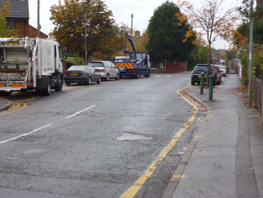
Kings Oak Primary School
Kings Oak Primary Framework School Travel Plan
2.2. Regional Policy
2.2.1. The London Plan
The Mayor of London is responsible for strategic planning in London. As part of this duty the Mayor is
charged with preparing a Spatial Development Strategy for London, named The London Plan. The London
Boroughs’ development plans must be in general conformity with The London Plan 2011.
The current London Plan was adopted in 2011. The Plan sets out an “integrated economic, environmental,
transport and social framework for the development of London, over the next 20-25 years”. It describes the
Mayor’s authority in major planning decisions in London and outlines proposals for implementation and
funding within the Plan periods. Various supplementary strategies, including the Mayor’s Transport Strategy
(May 2010), have also been published, all of which are intended to be consistent with The London Plan.
The Mayor’s vision is to “excel among global cities – expanding opportunities for all its people and
enterprises, achieving the highest environmental standards and quality of life and leading the world in its
approach to tackling the urban challenges of the 21st century, particularly that of climate change”.
In order to fully implement this vision The London Plan has been based on six objectives that ensure that
London is a city that:
Meets the challenges of economic and population growth;
Is internationally competitive and successful with a strong and diverse economy;
Has diverse, strong, secure and accessible neighbourhoods to which Londoners feel attached;
Delights the senses;
Becomes a world leader in improving the environment both locally and globally; and
Provides easy, safe and convenient access to jobs, opportunities and facilities.
The transport policies in the Plan are centred on the objective of making London a city where it is easy, safe
and convenient for everyone to access jobs, opportunities and facilities. The aim is to provide an efficient
and effective transport system which actively encourages more walking and cycling, makes better use of the
Thames, and support delivery of all the objectives of this Plan. The London Plan covers the spatial transport
policies for London only, with the more specific local policies being held in the Mayor’s Transport Strategy.
The London Plan sets out the Mayor’s strategic approach to encouraging the closer integration of transport
and development through schemes and proposals which aim to:
Encourage patterns and nodes of development that reduce the need to travel, especially by car;
Seek to improve the capacity and accessibility of public transport and cycling;
Support development that generates high levels of trips at locations with high public transport
accessibility and/or capacity;
Support measures that encourages shifts to more sustainable modes and appropriate demand
management; and
Promote walking.
Policy 3.18 of The London Plan 2011 highlights that the Mayor will support provision of early year and
primary schools to meet the demands of a growing and changing population. Development proposals which
enhance education and skills provision will be supported, including expansion of existing facilities. The
London Plan also states that those which address the current projected shortage of primary school places
will be particularly encouraged.
The London Plan also outlines car parking policy for different types of land use. However, education land use
is not included in these standards.
In reference to cycle parking standards, the London Plan states that for D1 (non-residential institutions),
primary and secondary schools should provide 1 space per 10 staff or students.
In order to implement the London Plan, the proposed cycle parking at Kings Oak Primary School has been
considered against the London Plan policy requirements. This FSTP contains initiatives in order to
encourage the use of sustainable travel.
Atkins Kings Oak Primary Framework School Travel Plan | Version 1.0 | December 2013 7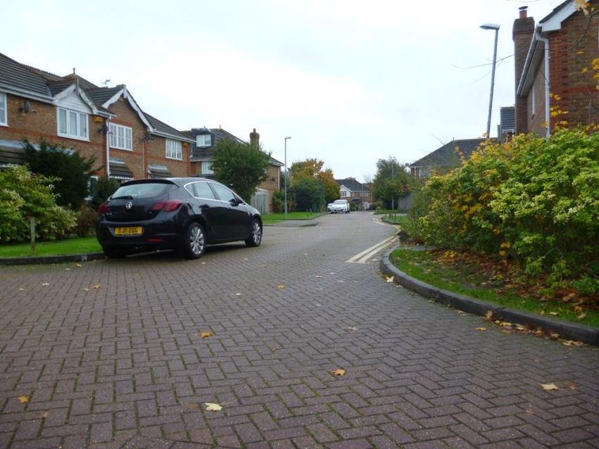
Kings Oak Primary School
Kings Oak Primary Framework School Travel Plan
2.2.2. The Mayor’s Transport Strategy
The Mayor’s Transport Strategy was published by the Greater London Authority (GLA) in May 2010 and
supersedes the first version published in July 2001 (including its revisions), providing the overall policy
framework for transport in London. The Mayor’s Transport Strategy has been developed from ‘Way to Go’,
published in Autumn 2008, and the results from extensive consultation. The policies and proposals within the
strategy have a broad horizon covering the next 20 years and cover all forms of transport. The strategy also
sets out how the Mayor proposes his policies will be delivered by the GLA, Transport for London (TfL), the
London Boroughs, the Department for Transport (DfT), Network Rail, train operating companies and other
delivery agencies.
The Mayor’s transport vision is that:
“London’s transport system should excel among those of world cities, providing access to opportunities for all
its people and enterprises, achieving the highest environmental standards and leading the world in its
approach to tackling urban transport challenges of the 21st century”.
The Mayor identifies six goals to set out how this vision should be implemented, which include:
Supporting economic development and population growth;
Enhancing the quality of life for all Londoners;
Improving the safety and security of all Londoners;
Improving transport opportunities for all Londoners;
Reducing transport’s contribution to climate change and improve its resilience; and
Supporting delivery of the London 2012 Olympic and Paralympic Games and its legacy.
Those strategic policies in the Mayor’s Transport Strategy which are relevant to Kings Oak Primary School
expansion are:
Policy 1: the Mayor, through TfL and working with stakeholders, will seek to develop London’s transport
system in order to accommodate sustainable population and employment growth;
Policy 9: the Mayor through TfL, and with other transport stakeholders, will use the local and strategic
development control process to seek to ensure that:
- All high trip generating developments are located in areas of high public transport accessibility,
connectivity and capacity; and
- The design and layout of development site maximise access on foot, cycle and to public transport
facilities.
Policy 11: the Mayor, through TfL, and working with other stakeholders, will seek to reduce the need to
travel; encourage the use of more sustainable, less congesting modes of transport; set appropriate
parking standards; and through investment in infrastructure, service improvements, promotion of smarter
travel initiatives and further demand management measures as appropriate, aim to increase public
transport, walking and cycling.
The expansion of Kings Oak Primary School has been assessed via numerous techniques including link
capacity utilisation and parked vehicle occupancy analysis to ensure the development is supporting the
population growth without causing detrimental impacts on the existing transport network. This FSTP has
been developed to further mitigate against any potential travel issues as a result of the expansion.
2.3. Local Policy
2.3.1. Kingston’s Local Development Framework and Core Strategy
Government regulations require the Council to prepare a series of planning policy documents. These
planning policy documents are collectively known as the Local Development Framework (LDF) and will
manage growth and development in the Borough. RBK’s LDF was adopted in March 2012 and replaces their
Unitary Development Plan 2005.
The Core Strategy, adopted in April 2012, sets out the vision, objectives and strategic policies for managing
future growth, change and development within the Borough. The Core Strategy sets out the framework to
deliver the spatial elements of the Kingston Plan (the Borough’s Community Plan). The Kingston Plan has
Atkins Kings Oak Primary Framework School Travel Plan | Version 1.0 | December 2013 8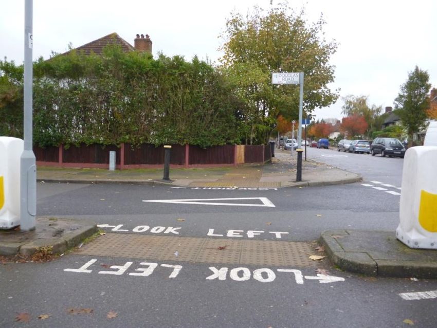
Kings Oak Primary School
Kings Oak Primary Framework School Travel Plan
been developed by local partners and sets out a collective vision for the future of the Borough which is: “We
want Kingston to be a place where people are happy, healthy and enjoy a good quality of life, in a safe and
tolerant environment, where business is prosperous, and where everyone in our community can contribute to
our success and reach their own full potential”.
The Core Strategy objectives and policies are aligned with the following three key themes:
Theme 1 – A Sustainable Kingston: protecting and enhancing the environment for us and for future
generations;
Theme 2 – Prosperous and Inclusive: sharing prosperity and opportunity; and
Theme 3 – Safe, Healthy and Strong: preventing problems and promoting responsibility and
independence.
The Core Strategy contains a Neighbourhood Policy for Maldens and Coombe area – Policy MC1 Malden
and Coombe Neighbourhood- which is directly relevant to this FSTP:
Policy (d) – “improving the local network of pedestrian and cycle routes”; and
Policy (k) – “considering the expansion of neighbourhood schools to provide sufficient school places to
meet the increase demand and changing needs”.
The Core Strategy also contains a number of Thematic Policies which are relevant to this FSTP as follows:
Policy CS5 Reducing the Need to Travel - this policy mainly relates to the location of major
developments in highly accessible areas;
Policy CS6 Sustainable Travel – to support and encourage the use of public transport, cycling and
walking the Council will promote and enhance the strategic cycling and walking networks; enhance and
promote the Borough’s network of quiet residential roads, traffic free routes and open spaces as
attractive, safe and convenient walking and cycling routes; provide infrastructure, including cycle lanes
and crossing facilities, to overcome specific barriers to cycling and walking trips; provide adequate cycle
parking at schools; and promote cycling and walking through school travel plans and cycle training;
Policy CS7 Managing Vehicle Use – to manage car use to ensure sustainability, road safety and
reduce congestion the Council will encourage the use of car sharing and car club schemes; support the
use of electric vehicles; implementing traffic management measures; promote park & ride; and manage
on and off street parking in the Borough;
Policy DM8 Sustainable Transport for New Development – to support and promote the use of
sustainable modes of travel to development site the Council will require all significant new development
(including schools) to develop and implement a robust and effective Travel Plan; to prioritise the access
needs of pedestrians and cyclists including the protection or enhancement of the strategic cycling and
walking networks; provide facilities on-site for cyclists; and require development to make a financial
contribution towards sustainable transport improvements and initiatives in line with the Planning
Obligations SPD/CIL;
Policy DM9 Managing Vehicle Use for New Development – to ensure that new development does not
contribute to congestion or compromise highway safety the Council will require all major developments
to submit a Transport Assessment based on TfL’s Best Practice Guidance; and require new
development to comply with car parking standards and implement parking management schemes;
Policy CS15 Future Needs of Kingston University, Kingston College and Schools – the Council will
facilitate improvements to the school estate and make provision for a permanent increase in the number
of school places to meet increasing demand through the expansion of existing schools and the provision
of new schools. The Council will continue the programme of partnership working with schools on travel
planning to reduce car use and the impact of school trips on local transport networks; and
Policy DM23 Schools – the Council will assess proposals for new schools and school expansion
considering the location and accessibility of the site in relation to the local highway network and its ability
to accommodate new or additional school trips without adverse impact on highway safety, safe and
convenient walking and cycling routes to schools.
The proposed expansion of Kings Oak Primary School is providing additional places for pupils to support the
growing population. The expansion includes secure covered cycle parking and has been assessed using
numerous techniques to ensure the development is not causing a significant increase in congestion. The
creation this FSTP is encouraging the use of sustainable transport modes which will help to ensure the
school is reducing its impact on the surrounding area.
Atkins Kings Oak Primary Framework School Travel Plan | Version 1.0 | December 2013 9
Kings Oak Primary School
Kings Oak Primary Framework School Travel Plan
2.3.2. Sustainable Transport SPD
The Sustainable Transport SPD was adopted in May 2013. This SPD contains local transport guidance for
development in the Borough to protect, promote and enhance sustainable modes of transport. Specifically
the SPD sets out the requirements and guidance for the production of travel plans and transportation
assessments, as well as recommendations / requirements regarding the installation and co-ordination of
sustainable transport facilities / initiatives on and off site.
The SPD states that a TA is required to demonstrate that trip generation from a site can be accommodated
without adversely affecting the safety, efficiency or sustainability of the transport network. The TA should
cover all aspects of movement by people and vehicles. It should demonstrate how the development affects
demand for travel, impacts upon highway and pedestrian safety and traffic congestion, and how any
additional demands for travel as well as servicing requirements will be met. It should demonstrate that the
scale and type of development is appropriate to the site and the surrounding transport infrastructure.
The SPD also outlines the requirements for a Travel Plan. The Travel Plan is a strategy to be implemented
when the development is completed to indicate how to manage travel flows to and from the site, reduce
transport impacts of the development, and deliver sustainable transport objectives. Travel Plans should
contain:
Targets for the modal split of the development;
An Action Plan of measures to reduce reliance on the car and support the use of sustainable modes of
transport to achieve proposed modal split targets. Examples of Travel Plan measures include cycle
parking, public transport incentives, car clubs or travel information; and
Proposals for the ongoing management, monitoring and funding of the Travel Plan.
The SPD contains parking standards for a range of developments however, for schools it is suggested that
parking should be addressed on a case-by-case basis.
A TA which is supporting this document provides a robust assessment demonstrating that the proposed trip
generation can be accommodated within the existing road network. This FSTP contains targets, an action
plan and monitoring techniques to ensure the FSTP is implemented and monitored regularly.
2.3.3. Local Implementation Plan 2
RBK’s Local Implementation Plan (LIP) sets out how the Council proposes to implement the Mayor’s
Transport Strategy at a local level. The current LIP – LIP2 – was adopted by the Council in December 2011.
As well as implementing the Mayor’s Transport Strategy, LIP2 is also consistent with the South London Sub-
Regional Transport Plan and reflects RBK’s local priorities and objectives. LIP2 complements both the LDF
and the Sustainable Communities Strategy (Kingston Plan) and has been developed as the transport
strategy for the borough.
LIP2’s vision for 2031 is “that we will have a safe, efficient, integrated, inclusive, responsive, and sustainable
transport network. The transport network will support the economic vitality of the borough, minimise its
impacts on (and where possible enhance) the natural and physical environment, minimise carbon emissions,
and support travel choices that meet the needs of residents, workers, and visitors to the borough…….
Residents, schools, workplaces, and other large organisations will be well informed of sustainable travel
options, and will have a strong understanding of the importance of using sustainable modes of transport.
Schools, workplaces, and large organisations will also support and encourage sustainable travel to their
sites”.
LIP2 is based around 5 general themes and accompanying objectives which outline aspirations for key areas
of improvement in the borough’s transport network up to 2031. In essence the themes and objectives seek to
improve the safety, efficiency, integration, inclusiveness, responsiveness, and sustainability of RBK’s
transport network. The five themes are:
To reduce transport’s contribution to climate change, and improve its resilience to the effects of climate
change;
To reduce congestion and traffic levels in RBK;
To create safer communities and a safer transport network;
To improve transport opportunities and enhance the quality of life for all RBK residents; and
To sustain and share economic growth and prosperity.
Atkins Kings Oak Primary Framework School Travel Plan | Version 1.0 | December 2013 10Kings Oak Primary School
Kings Oak Primary Framework School Travel Plan
LIP2 also contains a number of high level policies to act as guiding principles to achieve the LIP2 themes
and objectives, and to reflect the importance of reducing car use in the borough. The most relevant policies
which are directly related to this FSTP include:
Policy GP4 – the Council will ensure that new development promotes sustainable transport and
manages vehicle use (including encouragement of car free developments), and will develop Planning
Policy Guidance on sustainable transport;
Policy ST1 – to encourage more efficient and sustainable transport choices the Council will support
schools to better implement their travel plans to promote road safety and sustainable travel, prioritising
schools for support that have the most significant transport problems and the greatest potential for modal
shift; and
Policy C4 – to increase cycling uptake and ensure road safety the Council will…continue to work with
schools to deliver basic cycle training to primary school children.
This FSTP and the proposed cycle parking is ensuring the school is promoting sustainable travel to the site
which should help reduce the impact on the natural environment.
2.4. Summary
The proposals should address the above policies and documents by encouraging sustainable (non-car)
travel through the maximisation of access on foot, cycle and to public transport facilities, and the provision of
suitable and accessible facilities for cyclists and pedestrians. This will be achieved for the expansion through
the creation of this FSTP and providing secure cycle on-site as part of the proposals.
This FSTP has been developed as part of the proposals.
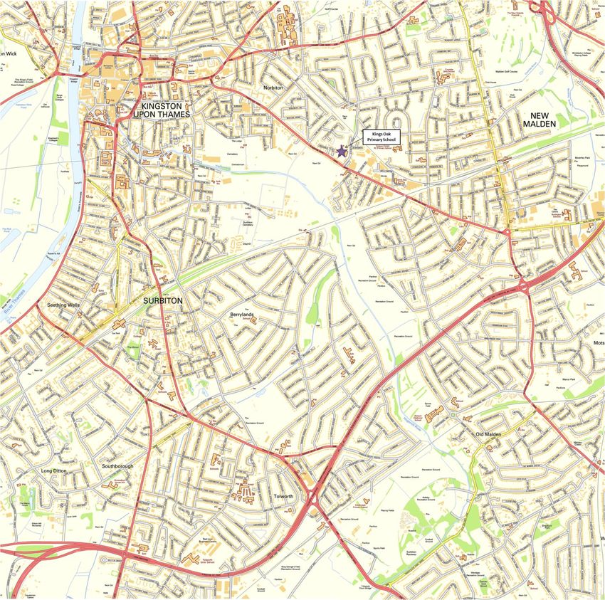
Atkins Kings Oak Primary Framework School Travel Plan | Version 1.0 | December 2013 11Kings Oak Primary School Kings Oak Primary Framework School Travel Plan 3. Site Assessment 3.1. Location of the School Kings Oak Primary School is located South East of Kingston Upon Thames within a largely residential area of New Malden, Kingston. The school is bordered by the A2043 Kingston Road to the South West, Archdale Place to the North West, Dickerage Lane to the East and grassland to the North of the site. Kings Oak Primary School is currently a two form entry (FE) Primary School catering for children from three to eleven years old, with capacity for up to 420 pupils, however there are two additional classes in Reception and Year one resulting in 477 pupils currently on roll. The school offers a breakfast club from 07:45 to 08:45 hours and after school club from 15:10 to 17:45 hours. These run outside of the school core hours 08:50 to 15:05 hours for reception and 08:45 to 15:10 hours for Key Stage 1 and Key Stage 2 pupils. Norbiton Children Centre is also located within the site, this provides daycare and early learning for zero to three year olds. The nursery is open 48 weeks a year 08:00 to 18:00 hours and is split into two day sessions 08:00 to 13:00 hours and 13:00 to 18:00 hours. The site location was shown in Figure 3-1. Atkins Kings Oak Primary Framework School Travel Plan | Version 1.0 | December 2013 12
Kings Oak Primary School
Kings Oak Primary Framework School Travel Plan

                                             Figure 3-1        Site Location

Contains Ordnance Survey Data © Crown copyright and database right 2013

Atkins Kings Oak Primary Framework School Travel Plan | Version 1.0 | December 2013   13
Kings Oak Primary School
Kings Oak Primary Framework School Travel Plan
3.2. Surrounding Road Network
The road network surrounding the site is illustrated in Figure 3-2 and described in more detail below.
Figure 3-2 Surrounding Road Network
Contains Ordnance Survey Data © Crown copyright and database right 2013
3.2.1. A2043 Kingston Road
The A2043 Kingston Road is a main A road which links New Malden in the South to Kingston Upton Thames
in the North. For the purpose of this assessment, the characteristics of the road between the junction with St
Johns Road and the junction with King Henry’s Road have been considered. The road is well lit, in a good
state of repair and approximately 10 metres wide when excluding the bus and cycle lanes.
The A2043 Kingston Road is subject to a 30 mph speed limit and there are traffic calming measures in place
in the form of signs indicating speed cameras. Single yellow lines span the entire length of both sides of the
carriageway preventing vehicles from parking along the carriageway.
There are footways located along both sides of the carriageway, these are even, well lit and range from two
to three metres wide. There are numerous Pelican Crossings located along the road, the crossing located
just North of the junction with Dickerage Lane is shown in Figure 3-3.
Atkins Kings Oak Primary Framework School Travel Plan | Version 1.0 | December 2013 14Kings Oak Primary School
Kings Oak Primary Framework School Travel Plan
Figure 3-3 A2043 Kingston Road Pelican Crossing
3.2.2. Dickerage Lane
Dickerage Road links the A2043 Kingston Road in the South to Clarence Avenue in the North. For purpose
of this assessment the section of interest is from the junction with the A2043 Kingston Road in the South to
the junction with Mt Pleasant Road in the North. The road is well lit in a good state of repair and
approximately eight metres wide.
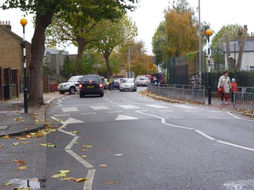
Dickerage Lane is subject to a 20mph speed limit and there are traffic calming measures in place in the form
of speed tables on approach to the junction with the A2043 Kingston Road, as shown in Figure 3-4.
Figure 3-4 Speed Table and 20mph Speed Limit enforced along Dickerage Lane at the junction
with the A2043 Kingston Road
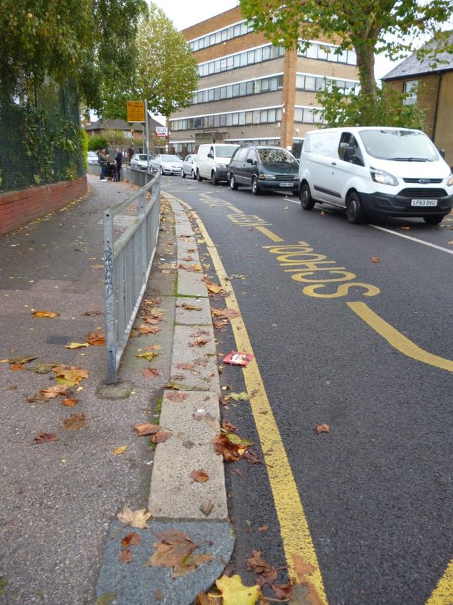
There are School Keep clear markings located directly outside the school entrances, one of which is shown
in Figure 3-5.
Atkins Kings Oak Primary Framework School Travel Plan | Version 1.0 | December 2013 15Kings Oak Primary School
Kings Oak Primary Framework School Travel Plan
Figure 3-5 School Keep Clear Markings along Dickerage Road, located outside the School
On approach to the junction with the A2043 Kingston Road there are single yellow lines along the Eastbound
carriageway and limited road markings along the Westbound carriageway, this results in numerous vehicles
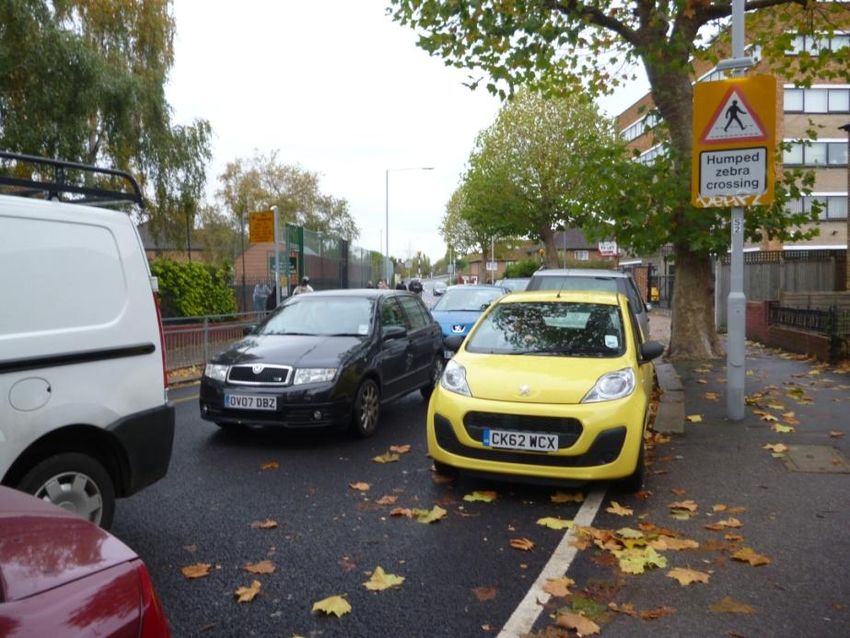
parking along the Westbound carriageway restricting the capacity of the road as shown in Figure 3-6.
Atkins Kings Oak Primary Framework School Travel Plan | Version 1.0 | December 2013 16Kings Oak Primary School
Kings Oak Primary Framework School Travel Plan
Figure 3-6 Parked vehicles along the Westbound carriageway on approach to the junction with
the A2043 Kingston Road
There are footways located along both sides of the carriageway, these are even, well lit and range from two
to four metres wide. There is a raised speed table with a zebra crossing located directly outside the school
th
entrance. On site observations undertaken on the 11 November during the AM peak indicated that this
crossing was well utilised by pupils of the school, this crossing is shown in Figure 3-7. The footway alongside
the school entrances is protected by a guarded railing, this can also be seen in Figure 3-7.
Figure 3-7 Zebra Crossing and guarded railing, located directly outside the School Entrance
3.2.3. Stafford Road & Lincoln Road
Stafford Road and Lincoln Road are residential cul de sacs. The roads are well lit in a good state of repair
and approximately six metres wide. The roads are subject to a 30mph speed limit. On site observations
th
undertaken on 11 November during the AM peak hour indicated that numerous vehicles parked along one
side of the carriageway along both roads, this does restrict the width and capacity of the roads as shown in
Figure 3-8 and Figure 3-9.
Atkins Kings Oak Primary Framework School Travel Plan | Version 1.0 | December 2013 17Kings Oak Primary School
Kings Oak Primary Framework School Travel Plan
There are footways located along both sides of the carriageway, these are even, well lit and approximately
2.5 metres wide. Due to the quiet nature of the road and numerous dropped kerbs, informal crossing can
occur.
Figure 3-8 Stafford Road at the Junction with Dickerage Lane, looking East
Figure 3-9 Lincoln Road at the Junction with Stafford Road
3.2.4. Warwick Road
Warwick Road is a no through road located North of the school off Dickerage Lane. The road is well lit in a
good state of repair and approximately 7.5 metres wide. There are double yellow lines located along the
Northbound carriageway but no parking restrictions along the Southbound carriageway which results in
numerous vehicles parking along the Southbound carriageway as shown in Figure 3-10.
Atkins Kings Oak Primary Framework School Travel Plan | Version 1.0 | December 2013 18Kings Oak Primary School
Kings Oak Primary Framework School Travel Plan
Figure 3-10 Parked Vehicles located along the Southbound carriageway along Warwick Road
There are footways located along both sides of the carriageway, these range from one metre along the
Southbound carriageway to three metres along the Northbound carriageway.
3.2.5. Avenue Terrace
Avenue Terrace is a no through traffic road located off the A2043 Kingston Road. The lane is well lit via flood
lights located within the retail park located South East of the road. The road contains some pot holes and
cracks as shown in Figure 3-11. There are single yellow lines located along one side of the carriageway and
signs indicating no stopping Monday to Saturday 07:00 – 19:00 hours, however on site observations
th
undertaken on 11 November during the AM peak hours indicated that numerous vehicles were parking
along this road as shown in Figure 3-11.
Figure 3-11 Avenue Terrance at the junction with A2043 Kingston Road
There are narrow footways located along both sides of the road, however along the Eastbound side the
footway stops approximately a third of the way along the road. These footways are approximately one metre
Atkins Kings Oak Primary Framework School Travel Plan | Version 1.0 | December 2013 19Kings Oak Primary School
Kings Oak Primary Framework School Travel Plan
wide. Due to the quite nature of the road and the dropped kerbs located at the junction with the A2043
Kingston Road informal crossing can occur.
3.2.6. California Road
California Road is a residential cul de sac located off the A2043 Kingston Road. The road is well lit in a good
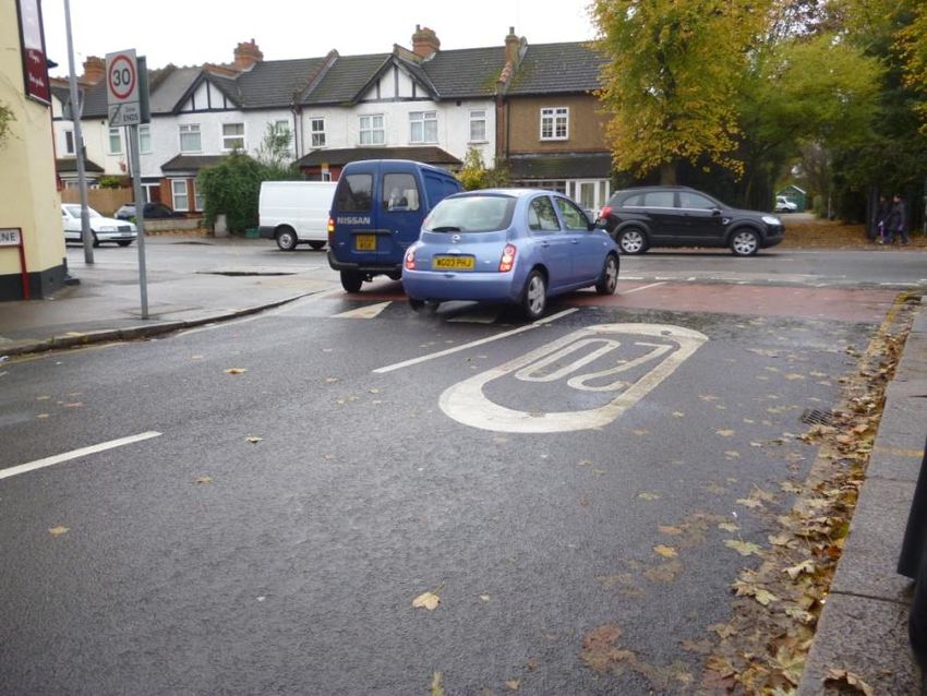
state of repair and eight metres wide. The road is subject to a 20mph speed limit and there are traffic
calming measures in place in the form of a speed tables such as the one located at the junction with the
A2043 Kingston Road as shown in Figure 3-12.
Figure 3-12 Speed Table along California Road located at the junction with the A2043 Kingston
Road
There are double and single yellow lines located along the carriageway on approach to the junction with the
A2043 Kingston Road along the Westbound and Eastbound carriageway respectively. Amongst these there
are off street parking areas which can accommodate approximately 13 vehicles, these spaces allow parking
for a maximum of two hours 07:00 to 19:00 hours with no return within two hours. On site observations
th
undertaken on 11 November during the AM peak indicated that these bays were well utilised as shown in
Figure 3-13.
Atkins Kings Oak Primary Framework School Travel Plan | Version 1.0 | December 2013 20Kings Oak Primary School
Kings Oak Primary Framework School Travel Plan
Figure 3-13 Parking sections located along California Road
Further along the road, after the junction with Willow Road there are no parking restrictions in place and on
th
site observations undertaken on 11 November during the AM peak indicted that numerous vehicles were
parked along this road, as shown in Figure 3-14.
Figure 3-14 Parked Vehicles along California Road, after the Junction with Willow Road
There are footways located along both sides of the carriageway, these are even, well lit and range from one
to three metres wide. There are no formal crossing points however, due to the quiet nature of the road it was
observed that numerous pedestrians crossed the road informally.
3.2.7. Archdale Place
Archdale Place is a residential cul de sac, located off the A2043 Kingston Road. The road is well lit in a good
state of repair and approximately 6.5 metres wide. There are some double yellow line marking on approach
to the junctions but other than this there are no other marking in place, which results in some vehicles
parking along the road as shown in Figure 3-15. There are footways located along some of the carriageway
Atkins Kings Oak Primary Framework School Travel Plan | Version 1.0 | December 2013 21Kings Oak Primary School
Kings Oak Primary Framework School Travel Plan
but not the entire length, however due to the quiet nature of the road the road can be used as a shared
space.
Figure 3-15 Some Vehicles Parked along Archdale Place
3.2.8. Norbiton Common Road
Norbiton Common Road is a residential cul de sac located off King Henry’s Road, it provides access to
Fleetwood Road and a pedestrian entrance to the school. The road is well lit, in a good state of repair and
approximately eight metres wide. The road is subject to a 20mph speed limit and there are traffic calming
measures in place in the form of speed humps. There are double yellow lines located along some sections of
the road on approach to junctions with other road. Vehicles are encouraged to park part on the kerb and part
in the road as shown in Figure 3-16.
Figure 3-16 Vehicles Parked along Norbiton Road.
There are footways located along both sides of the road, these are even, well lit and range from
approximately two to three metres, however when vehicles are parked along the footways this can restrict
Atkins Kings Oak Primary Framework School Travel Plan | Version 1.0 | December 2013 22Kings Oak Primary School
Kings Oak Primary Framework School Travel Plan
the width of the carriageway. There are no formal crossing points, however due to the quiet nature of the
road, dropped kerbs aid informal crossing.
There is also a footpath located off Norbiton Common Road which provides access to the school, this
footpath is shown in Figure 3-17.
Figure 3-17 Footpath located off Norbiton Common Road which leads to the School
3.2.9. Fleetwood Road
Fleetwood Road is a residential cul de sac located off Norbiton Common Road. The road is well lit in a good
state of repair and approximately seven metres wide. There are no parking restrictions in place except for on
approach to the junctions with Norbiton Common Road therefore people are encouraged to park their
vehicles half on the footway and half in the road as shown in Figure 3-18.
Figure 3-18 Vehicles Parked along Fleetwood Road
There are footways located along both sides of the carriageway, these are approximately three metres wide
but when vehicles are parked this can restrict the footway to approximately one to two metres wide.
Atkins Kings Oak Primary Framework School Travel Plan | Version 1.0 | December 2013 23Kings Oak Primary School Kings Oak Primary Framework School Travel Plan 3.2.10. King Henry’s Road King Henry’s Road is a residential cul de sac located off the A2043 Kingston Road, it provides access to Norbiton Road and Douglas Road. The road is in a good state of repair and approximately eleven metres wide. The road is subject to a 20mph speed limit and numerous vehicles park along both sides of the road as shown in Figure 3-19. Figure 3-19 Numerous Vehicles Parked along King Henry's Road, looking Southbound There are footways along both sides of the road, these are even well lit and approximately three metres wide. At the junction with the A2043 Kingston Road and the junction with Douglas Road there are bollards and tactile paving which help to aid crossing, as shown in .Figure 3-20. Figure 3-20 Formal crossing point along King Herny's Road at the Junction with Douglas Road Atkins Kings Oak Primary Framework School Travel Plan | Version 1.0 | December 2013 24
Kings Oak Primary School
Kings Oak Primary Framework School Travel Plan
3.3. Access Arrangements
When analysing the sites location the Public Transport Accessibility Level (PTAL) of the site has been
determined, the site is classified as a PTAL of 1b which is “poor” accessibility, however when reviewing the
surrounding area and needs of the development the site can be classified as assessable for all modes due to
the following factors:
Vehicular Access – Two vehicular entrances located along Dickerage Lane;
Pedestrian Access – A comprehensive pedestrian network exists within vicinity of Kings Oak Primary
School, which is where the majority of pupils currently live. Pelican crossing are located along the A2043
Kingston Road and a zebra crossing is located directly outside the school along Dickerage Lane;
Cycle and Scooter Facilities – There are a combination of cycle routes within the vicinity of the school,
these are classified as “routes signed for use by cyclists” and “routes on quieter routes recommenced by
cyclists” in Transport for London’s Cycling Guide 10. Although the school currently has no cycle parking
the expansion will provide 30 cycle spaces;
Bus Access – The site is served by three bus routes which provide connections to Sutton, Tooting and
Morden. The nearest stop is approximately 200 metres away from the school, located along the A2043
Kingston Road.
Rail Access – The nearest railway station is Norbiton Station which is approximately 1.2 kilometres to the
North East of the school however, a number of bus services link directly to the station;
Highway Network – The local road network is mainly residential in nature, with the majority of speed
limits being a maximum of either 20 or 30 mph. The A2043 is a much busier road than all of the other
roads surrounding the school as this links Cheam in the South to Kingston Upon Thames in the North;
Car Parking – On-site car parking can accommodate 28 vehicles, although one is a disabled bay, one is
occupied by the school mini bus and three are allocated to Norbiton Children’s Centre; and
Deliveries and Servicing – Currently occurs within the staff car park and will continue to with the
expansion.
In summary the location and the surrounding environment would support sustainable travel for staff and
pupils who live within the vicinity of Kings Oak Primary School. The remainder of the FSTP provides
information on the management, measures and implementation, monitoring and review.
3.4. Road Safety
To inform the background analysis of the site accident data has been obtained from Transport for London.
st
The accident data has been collected for a three year period from 1 January 2010 to 31 July 2013 and
covers the area around the site, including the A2043, Kingston Road, Dickerage Lane, Warwick Road,
Lincoln Road, Avenue Terrace, St Johns Road, Georgia Road, California Road, Willow Road, Archdale
Place, King Henry’s Road, Fleetwood Road and Norbiton Common Road.
A summary of the accidents recorded in the last three years (2010 onwards) is given in Table 3-1 and
indicative location shown in Figure 3-21.
In total, covering the area outlined above, there were 27 accidents recorded within the three year period.
Only two accidents occurred during core school travel times (assumed to be between 08:00 to 09:00 and
14:30 to15:30 hours), of which none involved a child of Primary School age.
The closest accidents to the school occurred along Kingston Road at the junction with Dickerage Lane where
seven accidents occurred. Six of these accidents were slight and one was serious. The majority of these
accidents involved a pedal cyclist and a car where either a vehicle door hit a cyclist, a driver failing to look
and/ or vision was impaired.
Five accidents were classified as serious. One was at the junction of Kingston Road/Dickerage Lane and the
others were all located along Kingston Road at junctions with other roads. These accidents tended to be due
to people failing to look, poor judgement and sudden braking.
The full accident breakdown can be seen in Table 3-1.
Atkins Kings Oak Primary Framework School Travel Plan | Version 1.0 | December 2013 25Kings Oak Primary School
Kings Oak Primary Framework School Travel Plan
Table 3-1 Three Year Accident Summary
Within Core
Day / Year / Modes Involving Primary
Location Injury Description of Accident Main Cause School Travel
Time Involved School aged Child
Times
Drive of vehicle one fell
Kingston Road J/W King
08/03/2010 Slight 3 Cars asleep/became ill and collided Fatigue
Henry’s Road
with vehicle 2 and 3
Vehicle turned without looking
Kingston Road J/W M/C, Taxi, and collided with vehicle 2 Poor Turn or
14/05/2010 Serious
California Road Car causing rider to fall off & debria manoeuvre
hit vehicle 3.
Kingston Road J/W Pedal Pedal cyclist baked too hard to
01/06/2010 Serious Sudden Braking
Henry’s Road Cycle avoid accident and lost control
Pedestrian was crossing the
Kingston Road J/W St Car & Failed to look
21/07/2010 Serious road and walked into the side of
Johns Road Pedestrian properly
the vehicle
Vehicle swerved around a
Kingston Road J/W Car &
22/07/2010 Slight parked car and collided with Swerved
Archdale Place Pedestrian
pedestrian crossing the road
Kingston Road J/W One Vehicle drove into the back Following too
24/08/2010 Slight 2 Cars
Georgia Road of another close
Kingston Road 40m
Car & Pedestrian ran into the road into Failed to look
03/09/2010 South East J/W Slight
Pedestrian the vehicle properly
California Road
Car & Passenger in the back of one
Kingston Road J/W Vehicle door
29/11/2010 Slight Pedal vehicle opened the door into the
Dickerage Lane opened
Cycle cyclist
Car & Cyclist was riding across the
Kingston Road J/W St Failed to look
02/01/2011 Slight Pedal junction & collided with the
John’s Road properly
Cycle vehicle
Kingston Road 100m
One vehicle drove into the rear Careless/reckles
27/03/2011 North West J/W Slight 2 Cars
of a parked vehicle s/in a hurry
Dickerage Lane
11/06/2011 Slight Vehicle was overtaking the bus
Kingston Road J/W Bus/Coac Inexperience of
who was pulling into the bus stop
Atkins Kings Oak Primary Framework School Travel Plan | Version 1.0 | December 2013 26Kings Oak Primary School
Kings Oak Primary Framework School Travel Plan
Archdale Place h & Car and hit the rear of the bus driving on the left
Car &
Kingston Road J/W Vehicle turned left across path of Failed to look
11/07/2011 Slight Pedal
Dickerage Lane cyclist and collided with cyclist properly
Cycle
Disobeyed give
Kingston Road J/W Car & Vehicle turned right and collided
28/10/11 Slight way or stop sign
California Road motorcycle with passing motorcyclist
or markings
Kingston Road 20m One vehicle drove into the back
Following too
25/11/11 North West Georgia Slight 3 Cars of another pushing this vehicle
close
Road into the back of the third vehicle
Car & Vehicle pulled out into path of Disobeying give
Kingston Road J/W
30/11/11 Serious Pedal cyclist knocking them off their way or stop sign
Dickerage Road
Cycle bike or making
Vehicle turned right and collided
Kingston Road J/W King Car & Poor turn or
23/01/12 Slight with the motorcyclist who was
Henry’s Road Motorcycle manoeuvre
overtaking static traffic
Kingston Road 20m One vehicle drove into the back
Following too
26/03/2012 North West J/W Slight 2 Cars of another who stopped for
close
Dickerage Lane pedestrians on the crossing
Car &
Douglas Road J/W King Vehicle and cyclist collided at the Failed to look
29/03/2012 Slight Pedal
Henry’s Road junction properly
Cycle
Crossed road
Pedestrian crossed the road in
Kingston Road J/W Car & masked by
27/04/2012 Slight between slow traffic and was hit
Dickerage Lane Pedestrian stationary or
by the vehicle
parked vehicle
Goods
vehicle Mobility scooter attempted to Failed to judge
Dickerage Lane J/W
10/08/2012 SlightKings Oak Primary School
Kings Oak Primary Framework School Travel Plan
parked vehicle
Car & Traffic stopped as the vehicle Visions affected-
Kingston Road J/w
13/03/2013 Slight Pedal was turning right causing a stationary or
Dickerage Lane
Cycle collision parked vehicles
Car &
Car drove into the back of
Kingston Road J/W Goods Distraction in
28/03/2013 Slight stationary good vehicle who was
Dickerage Lane Vehicle vehicle
waiting to turn
3.5T
Car &
Car slowed down to turn right Failed to judge
Kingston Road J/W King Goods
24/04/2013 Slight and good vehicle drove into the other persons
Henry’s Road Vehicle
back of the car path of speed
3.5T
Kingston Road 30m Vehicle mounted footway to park
Car & Vehicle travelling
17/16/2013 North West J/W Georgia Slight near a shop and collided with the
Pedestrian along pavement
Road pedestrian
Georgia Road J/W Car & Pedestrian crossed the road into Failed to look
23/06/13 Slight
Kingston Road Pedestrian path of the vehicle properly
Atkins Kings Oak Primary Framework School Travel Plan | Version 1.0 | December 2013 28Kings Oak Primary School
Kings Oak Primary Framework School Travel Plan
Figure 3-21 Accident Locations
Contains Ordnance Survey Data © Crown copyright and database right 2013
It should be noted that some locations shown in Figure 3-21 are the location of more than one accident.
Atkins Kings Oak Primary Framework School Travel Plan | Version 1.0 | December 2013 29Kings Oak Primary School
Kings Oak Primary Framework School Travel Plan
4. Existing Travel Patterns
4.1. Existing Mode Split
The baseline survey data has been provided by the school in the STP Information sheet. The resultant trips
and mode share for the pupils are shown in Table 4–1 and for the staff are shown in Table 4–2.
Table 4–1 Existing Pupil Trips and Mode Share for Kings Oak Primary School
Mode Pupils Trips Pupil Mode Share
Car/Van 134 28%
Car Share 10 2%
Park and Stride 5 1%
Public Bus 86 18%
School Bus 14 3%
Bicycle 10 2%
Scooter 19 4%
Walk only 200 42%
TOTAL* 477 100.0%
*Figures may not add up due to rounding of numbers
Table 4–2 Existing Staff Trips and Mode Share for Kings Oak Primary School
Mode Staff Trips Staff Mode Share (%)
Car/Van 36 46%
Car Share 7 9%
Park and Stride 2 2%
Rail 3 4%
Tube 2 2%
Public Bus 7 9%
Bicycle 7 9%
Walk only 15 19%
TOTAL* 78 100%
*Figures may not add up due to rounding of numbers
From this information it can be concluded that the just under half of all the pupils walk to school and just
under a third drive to school. It should be noted that just under half of the staff drive to the site.
4.2. Geographical Locations of Staff and Pupils
Atkins has been provided with anonymous home postcode data for staff and pupils as summarised in Table
4-3 and presented illustratively in Figure 4-1 (although it should be noted that not all points are illustrated on
the map as they live outside the mapped area).
Atkins Kings Oak Primary Framework School Travel Plan | Version 1.0 | December 2013 30You can also read