THE MARYLAND-NATIONAL CAPITAL PARK AND PLANNING COMMISSION
←
→
Page content transcription
If your browser does not render page correctly, please read the page content below
MONTGOMERY COUNTY PLANNING DEPARTMENT
THE MARYLAND-NATIONAL CAPITAL PARK AND PLANNING COMMISSION
MCPB
Item No.
Date: 7/30/2020
Kaiser Permanente Aspen Hill, Preliminary No. 120200130 & Site Plan No. 82018007A
Troy Leftwich, Planner Coordinator, Area 2 Division, Troy.Leftwich@montgomeryplanning.org , 301-495-4553
Parker Smith, Senior Planner, Area 2 Division, Parker.Smith@montgomeryplanning.org, 301-495-1327
Patrick Butler, Supervisor, Area 2 Division, Patrick.Butler@montgomeryplanning.org, 301.495.4561
Carrie Sanders, Chief, Area 2 Division, Carrie.Sanders@montgomeryplanning.org, 301.495.4653
Completed:7/20/2020
Description
Preliminary Plan: Request for a maximum of 180,000
square-foot for a medical facility, built over two phases;
for a maximum of 846 parking spaces.
Site Plan: Request to construct a 180,000 square-foot
medical facility, built over two phases; phase 1 to
consist of 130,000 square feet of development, 542
parking spaces, and 63,144 square feet of open space;
phase 2 to consist of 180,000 square feet of
development, 846 parking spaces, and reduces the
open space to 44,148 square feet.
Location: Northwest quadrant of the intersection of
Aspen Hill Road and Route 185-Connecticut Avenue.
Master Plan: 2015 Aspen Hill Minor Master Plan
Amendment.
Zone: CRT-1.5, C-0.5, R-1.0, H-60.
Property Size: 10.04 acres.
Acceptance Date: November 22, 2017.
Applicant: Kaiser Permanente.
Review Basis: Chapter 59, Zoning Ordinance.
Summary
Staff recommends approval with conditions.
The Application includes two waivers to modify or exceed the Zoning Ordinance, Chapter 59, including the
Build-to-Area front setback from Connecticut Avenue (Section 59-4.5.3.C.3.b) and the screening requirement
adjacent to the Home Depot property that is zoned R-90 (Section 59-6.2.9.C.3.b.).
The Applicant will construct a sidepath along the Connecticut Avenue and Aspen Hill Road frontages of the site.
The Community has concerns regarding the amount of traffic entering the property from Aspen Hill Road.
SECTION 1: RECOMMENDATION AND CONDITIONS

Preliminary Plan No. 120200130
Staff recommends approval of Preliminary Plan No. 120200130. All site development elements shown
on the latest electronic version of Preliminary Plan No. 120200130 submitted via ePlans as of the date of
this Staff Report are binding:

1.      This Preliminary Plan is limited to one lot for 180,000 square feet of medical office uses.

Adequate Public Facilities and Outside Agencies

2.      The Adequate Public Facility (“APF”) review for the Preliminary Plan will remain valid for ten years
        (120) months from the date of mailing of this Planning Board Resolution.

Outside Agencies

3.      The Planning Board has reviewed and accepts the recommendations of the Montgomery County
        Department of Transportation (“MCDOT”) in its letter dated April 28, 2020 and incorporates them
        as conditions of the Preliminary Plan approval. The Applicant must comply with each of the
        recommendations as set forth in the letter, which may be amended by MCDOT if the amendment
        does not conflict with any other conditions of the Preliminary Plan approval.

4.      Before recording a plat for the Subject Property, the Applicant must satisfy MCDOT’s
        requirements for access and improvements.

5.      Before the issuance of access permits, the Applicant must satisfy the Maryland State Highway
        Administration’s requirements for access and improvements.

6.      The Planning Board has reviewed and accepts the recommendations of the Montgomery County
        Department of Permitting Services (“MCDPS”) – Water Resources Section in its stormwater
        management concept letter dated June 15, 2020 and incorporates them as conditions of the
        Preliminary Plan approval. The Applicant must comply with each of the recommendations as set
        forth in the letter, which may be amended by MCDPS – Water Resources Section if the
        amendment does not conflict with any other conditions of the Preliminary Plan approval.

7.      The Planning Board has reviewed and accepts the recommendations of the Montgomery County
        Department of Permitting Services (“MCDPS”), Fire Department Access and Water Supply Section
        in its letter dated May 16, 2020 and incorporates them as conditions of approval. The Applicant
        must comply with each of the recommendations as set forth in the letter, which MCDPS may
        amend if the amendment does not conflict with other conditions of Preliminary Plan approval.

Other Approvals

Concurrent Site Plan Approval

8.      Before submitting a record plat application for the Subject Property, the Applicant must receive
        Staff certification of Site Plan No. 82018007A. The number and location of site elements
        including but not limited to buildings, on-site parking, site circulation, sidewalks, open spaces,
        onsite amenities, and sidepath is determined through site plan review and approval.

                                                         2
9.     If an approved site plan amendment for the Subject Property substantially modifies the lot or
       right-of-way configuration or quantities shown on this Preliminary Plan, the Applicant must
       obtain approval of a Preliminary Plan amendment before certification of the site plan
       amendment. Minor adjustments to the lot configuration as result of final design of the traffic
       signal and related equipment at the shared driveway entrance and Connecticut Avenue at
       permitting with the Maryland State Highway Administration (MDSHA) will not require an
       amendment to the Preliminary Plan or Site Plan.

Transportation

Existing Frontage Improvements

10.    Prior to the recordation of plat, the Applicant must satisfy all necessary requirements of MCDPS
       and MDSHA to construct a 10-foot wide sidepath along the Property frontage on Aspen Hill Road
       and Connecticut Avenue.

Off-Site Improvements

11.    The Applicant must construct a 10-foot-wide sidepath along the north side of Aspen Hill Road and
       the west side Connecticut Avenue. The sidepaths must extend offsite, within the public right-of-
       way, and connect at the intersection of Aspen Hill Road and Connecticut Avenue and maintain the
       10-foot-width, to the extent possible.

Record Plats

12.    Environmental remediation, clearing and/or grading is permitted only for the removal of the
       existing Vitro/BAE Building on the Property prior to recordation of plat(s).

Easements

13.    The record plat must show necessary easements.

14.    The record plat must reflect common ingress/egress and utility easements over all shared
       driveways.
       a. The record plat must reflect building restriction lines, as shown on the Preliminary Plan, to
           show the location of the Floodplain, as approved my MCDPS.

Notes and Labels

15.    The record plat must reflect all areas under common ownership.

Certified Preliminary Plan

16.    The Applicant must include the stormwater management concept approval letter and Preliminary
       Plan Resolution on the approval or cover sheet(s).

17.    The Certified Preliminary Plan must contain the following note:

                                                       3
Unless specifically noted on this plan drawing or in the Planning Board conditions of approval, the
         building footprints, building heights, on-site parking, site circulation, and sidewalks shown on the
         Preliminary Plan are illustrative. The final locations of buildings, structures and hardscape will be
         determined at the time of issuance of building permit(s). Please refer to the zoning data table for
         development standards such as setbacks, building restriction lines, building height, and lot
         coverage for each lot.

18.      Prior to submittal of the Certified Preliminary Plan, the Applicant must make the following
         changes:
            a. Show resolutions and approval letters on the certified set.
            b. Update the final location of the Floodplain line with BRL as shown on the FCP and Certified
                Preliminary Plan.
            c. PIE must include all sidepaths, traffic signal boxes and bus stop shelters along Connecticut
                Avenue, and the final locations will be confirmed by MCDOT, MDSHA, and MCDPS.
            d. The Limits of Disturbance on the Final Forest Conservation Plan must be consistent with
                the LOD on the Sediment and Erosion Control Plan.

Site Plan No. 82018007A
Staff recommends approval of Site Plan Amendment No. 82018007A and accompanying waivers. All site
development elements shown on the latest electronic version of the Site Plan Amendment No.
82018007A submitted via ePlans as of the date of this Staff Report are required. The previously
approved plan No. 820180070, findings, and conditions of approvals are no longer valid and are
superseded by the following conditions. 1

Density, Height & Housing

1.       Density
         The Site Plan is limited to a maximum of 130,000 square feet of medical office use for Phase 1,
         and an additional 50,000 square feet for Phase 2 for total maximum density of 180,000 square
         feet of development on the Subject Property.

2.       Height
         The development is limited to a maximum height of 60 feet, as measured from the building height
         measuring point, as illustrated on the Certified Site Plan.

Open Space, Facilities and Amenities

3.       Public Open Space, Facilities, and Amenities
         a. The Applicant must provide a minimum of ten percent (10%) of public open space on-site for
            Phase 1 and 2.
         b. Prior to issuance of the Final Use and Occupancy Certificate for Phase 1, the Applicant must
            construct the streetscape improvements along the Property’s frontage on Aspen Hill Road
            and Connecticut Avenue.
         c. Prior to issuance of the Final Use and Occupancy Certificate for Phase 1, all public open space
            and onsite amenities associated with Phase 1 on the Subject Property must be completed.

1 For the purposes of these conditions, the term “Applicant” shall also mean the developer, the owner or any successor (s) in
interest to the terms of this approval.

                                                                  4
Prior to issuance of the Final Use and Occupancy Certificate for Phase 2, all public open space
           and onsite amenities associated with Phase 2 on the Subject Property must be completed.
        d. All parking spaces above the 4.0 ratio parking for Medical uses must be made available to the
           public for parking.
        e. Landscape buffer along the western boundary must provide fencing between existing lots 57-
           60 on Landgreen Street.

Site Plan

4.      Site Design
        The exterior architectural character, proportion, materials, and articulation must be substantially
        similar to the schematic elevations shown on Sheets A301-A305 of the submitted architectural
        drawings, as determined by M-NCPPC Staff.

5.      Lighting
        a. Prior to Certified Site Plan, the Applicant must provide certification to Staff from a qualified
            professional that the exterior lighting in this Site Plan conforms to the latest Illuminating
            Engineering Society of North America (IESNA) recommendations (Model Lighting Ordinance-
            MLO: June 15, 2011, or as superseded) for a development of this type. All onsite exterior area
            lighting must be in accordance with the latest IESNA outdoor lighting recommendations
            (Model Lighting Ordinance-MLO: June 15, 2011, or as superseded).
        b. All onsite down-lights must have full cut-off or BUG-equivalent fixtures.
        c. Deflectors will be installed on all fixtures to prevent excess illumination and glare.
        d. Illumination levels generated from on-site lighting must not exceed 0.5 footcandles (fc) at any
            property line abutting public roads and residentially developed properties.
        e. Streetlights and other pole-mounted lights must not exceed the height illustrated on the
            Certified Site Plan.
        f. On the rooftop of the building, the light pole height must not exceed the height illustrated on
            the Certified Site Plan.

Environment

6.      Forest Conservation & Tree Save
        The development must comply with the Final Forest Conservation Plan.

7.      The Limits of Disturbance (LOD) on the Final Forest Conservation Plan must be consistent with
        the LOD on the Sediment and Erosion Control Plan.

8.      There shall be only environmental remediation, clearing, grading, or demolition for the removal
        of existing the Vitro/BAE Building on the Property prior to receiving approval of the Final
        Sediment and Erosion Control Plan.

Transportation & Circulation

9.      Transportation
        Prior to any building permit for Phase 2 the Applicant must construct and install the traffic signal
        at the intersection of Connecticut Avenue and the shared driveway with Home Depot, subject to
        MDSHA review and approval.

                                                         5
10.   Pedestrian & Bicycle Circulation
      a. The Applicant must provide 32 long-term and 9 short-term bicycle parking spaces. The long-
         term spaces must be secured, bicycle lockers, as shown on the Site Plan, and the short-term
         spaces must be inverted-U racks (or approved equal) installed in a location convenient to the
         main entrance (weather protected preferred). The specific location(s) of the short-term
         bicycle rack(s) must be identified on the Certified Site Plan.
      b. Prior to issuance of the first Use and Occupancy Permit, the Applicant must construct a 10-
         foot-wide sidepath along the north side of Aspen Hill Road and the west side of Connecticut
         Avenue. The sidepaths must extend offsite and connect at the intersection of Aspen Hill
         Road and Connecticut Avenue, within the public right-of-way, and maintain the 10-foot-
         width, to the extent possible.

11.   Fire and Rescue
      The Planning Board has reviewed and accepts the recommendations of the Montgomery County
      Department of Permitting Services (MCDPS), Fire Department Access and Water Supply Section
      in its letter dated May 16, 2020, and hereby incorporates them as conditions of approval. The
      Applicant must comply with each of the recommendations as set forth in the letter, which MCDPS
      may amend if the amendments do not conflict with other conditions of Preliminary Plan approval.

12.   Site Plan Surety and Maintenance Agreement
      Prior to issuance of any building permit, sediment control permit, or Use and Occupancy
      Certificate, the Applicant must enter into a Site Plan Surety and Maintenance Agreement with the
      Planning Board in a form approved by the M-NCPPC Office of General Counsel that outlines the
      responsibilities of the Applicant. The Agreement must include a performance bond(s) or other
      form of surety in accordance with Section 59.7.3.4.K.4 of the Montgomery County Zoning
      Ordinance, with the following provisions:
        a. A cost estimate of the materials and facilities, which, upon Staff approval, will establish the
              surety amount.
        b. The cost estimate must include applicable on-site Site Plan elements, including, but not
              limited to plant material, lighting, outdoor recreational facilities, site furniture, fences,
              railings, private utilities, paths, sidewalks, sidepaths, storm drainage facilities, street trees
              and street lights. The surety must be posted before issuance of any building permit of
              development and will be tied to the development program.
        c. The bond or surety must be tied to the development program, and completion of all
              improvements covered by the surety for each phase of development will be followed by a
              site plan completion inspection. The surety may be reduced based upon inspector
              recommendation and provided that the remaining surety is sufficient to cover completion
              of the remaining work.

13.   Development Program
      The Applicant must construct the development in accordance with a development program table
      that will be reviewed and approved prior to the approval of the Certified Site Plan.

14.   Certified Site Plan
      Before approval of the Certified Site Plan the following revisions must be made and/or
      information provided subject to Staff review and approval:
      a. Include the stormwater management concept approval letter, development program, and
          Site Plan and Preliminary Plan resolutions on the approval or cover sheet(s).

                                                         6
b. Add a note to the Site Plan stating that “M-NCPPC Staff must inspect all tree-save areas and
   protection devices before clearing and grading.”
c. Add a note stating that “Minor modifications to the limits of disturbance shown on the site
   plan within the public right-of-way for utility connections may be done during the review of
   the right-of-way permit drawings by the Department of Permitting Services.”
d. Modify data table to reflect development standards approved by the Planning Board.
e. Ensure consistency of all details and layout between Site and Landscape plans.
f. Circulation plans for the truck loading must show access from Connecticut Avenue.
g. Aspen Hill Road entrance must be designed as a “right in and out” channelized access, to be
   confirmed by MCDOT and Planning Staff.
h. Architectural windows on all elevations (per sheets A0303.1 and A0304.1) must be consistent.
i. PIE must include all sidepaths, traffic signals boxes and bus stop shelters, along Connecticut
   Avenue and final locations will be confirmed by MCDOT, MDSHA, and MCDPS.
j. The long-term spaces must be in a secured bike lockers, as shown on the Site Plan, and the
   short-term spaces must be inverted-U racks, or approved equal rack, installed in a location
   convenient to the main entrance, and it is preferred that the racks are protected from the
   weather. The specific location(s) of the short-term bicycle rack(s) must be identified on the
   Certified Site Plan
k. Revise the variance request to remove tree #12 and add tree #1 to the requested list.

                                               7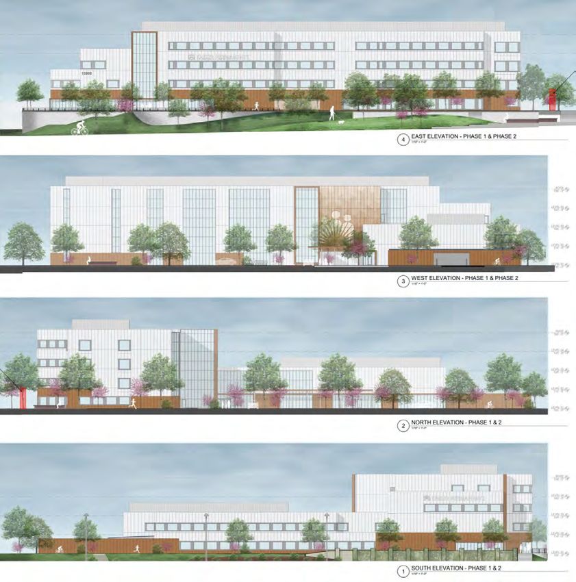
SECTION 2: SITE DESCRIPTION

Site Vicinity

The Vitro Corporation Property (Property or Subject Property – outlined in red in Figure 1 below),
located at 4115 Aspen Hill Road, is situated southwest of the major intersection of Connecticut Avenue
(Maryland Route 185) and Georgia Avenue (Maryland Route 97), within the 2015 Aspen Hill Minor
Master Plan Amendment (Master Plan) area. The 10.04-acre Property has been vacant since 2010.
Although the site had been a long-standing employer in the area, it more recently has been used for law
enforcement tactical training purposes.

The Property holds two formal addresses:
1.     13905 Connecticut Avenue, Silver Spring, MD 20906; and
2.     4115 Aspen Hill Road, Rockville, MD 20853

                           Figure 1: The Subject Property highlighted in red

The Property is located immediately south from The Home Depot, located at 14000 Georgia Avenue in
Aspen Hill, with a shared private entrance from Connecticut Avenue. Figure 2 shows the site’s
confronting uses. Single-family detached homes, interspersed with institutional uses, are predominant
to the south and west. Immediately to the west, the Aspen Hill residential community made up of single-
family detached houses are located across the green buffer of the site.

                                                       8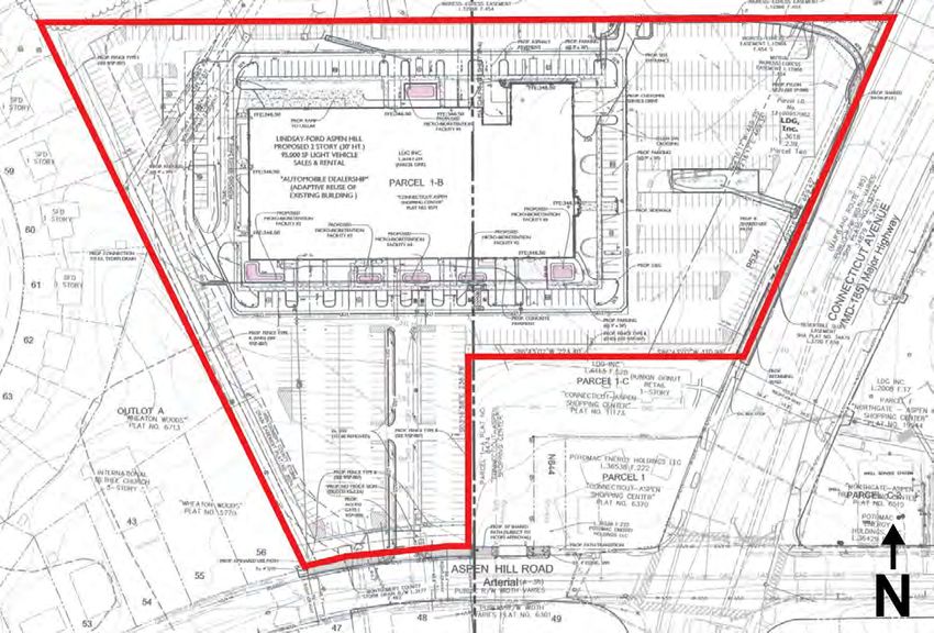
Figure 2: Bird’s eye view of the subject property
Site Description

Located about 1.9 miles south of the Inter-County Connector (MD 200) and about 1.9 miles from the
Glenmont Metro Station, the Vitro office building and associated parking encompass approximately 10
acres of the Property. Initially built in 1968, the multi-story building consists of approximately 265,000
square feet of gross floor area with a basement level for storage and parking. The Vitro Corporation was
a major United States defense contractor which became part of BAE Systems Inc. in 1999. In the early
1980s, the Vitro Corporation was Montgomery County’s largest civilian employer, with somewhere
around 5,000 employees in the area.

At the steepest point of the Property, there is approximately 10 feet of grade change from the top of the
curb at Connecticut Avenue to the parking area. There are no forest or streams on-site but there is an
engineered floodplain associated with an off-site stormwater management facility.

                                                        9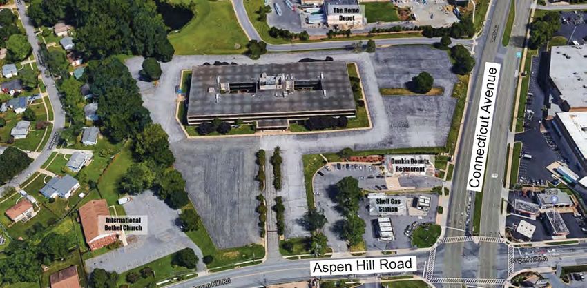
Figure 3: The Vitro/BAE Building; View from Aspen Hill Road entrance; Elevation change on Connecticut
                                   Avenue; Western fence in disrepair

Previous Approvals

The Planning Board approved Site Plan application 820180070, submitted by Lindsay Ford, on August 1,
2018. That approval was to replace the existing 265,000 square-foot vacant office building with a
95,000 square-foot car dealership. The project included landscape and hardscape improvements to the
existing parking lot, and various pedestrian and vehicular upgrades. The new dealership would maintain
roughly the same building footprint as the existing vacant office building.

The proposed Lindsay Ford project was never constructed, and ownership has now changed hands to
Kaiser Permanente.

                                                     10
Figure 4: Lindsay Ford Site Plan 820180070
SECTION 3: PROJECT DESCRIPTION
Proposal
The Applicant is proposing to redevelop the Property into a Kaiser Permanente medical facility of up to
180,000 square feet, to be developed on a single lot. The site plan application covers two phases that
will be constructed for this project.
The Phase 1 will include the first 130,000 square feet of medical center development, 542 parking
spaces in a surface parking lot, and 63,144 square feet of open space. The open space includes a plaza
at the northeast corner of the property, a health and wellness trail that circulates around the surface
parking lot at the northwest of the property, and a community garden at the center-west portion of the
property.
The Phase 2 will include the construction of an additional 50,000 square-foot northern wing of the main
building, as well as a new structured parking garage at the center-north of the property, which will
include an addition of 304 parking spaces to bring the project total to 846 spaces. Phase 2 will also
include an enlarged community garden and open space at the center west of the property.
As part of the project, the applicant will also construct a sidepath along Connecticut Avenue and Aspen
Hill Road. On Connecticut Avenue, the sidepath will continue south past the property boundaries and in
front of the Dunkin Donuts and gas station properties, where it will then tie into the existing sidewalk.
On Aspen Hill Road, the sidepath continues off-site, in front of the Dunkin Donuts and gas station
properties (using the available right-of-way), before merging with the existing sidewalk at the corner.
Existing utility poles cannot be relocated, preventing the expansion of the sidepath at this location. The
11surface parking lot abuts residential uses on the subject property’s northern western property line, and
this area will include screening required by the zoning code for parking lots abutting residential uses. To
the north the project abuts Home Depot, and to the southwest the project abuts a church, neither of
which require screening from the surface parking lot. The project will have two points of entry. The
Aspen Hill Road access point will be an employee entrance only and will be channelized to restrict left
turn movement in to the site. The main access from Connecticut Avenue will be a new signalized
intersection.
Figure 5: Kaiser Permanente Aspen Hill Site Plan 82018007A
Preliminary Plan lot configuration.
The Property exists in two different parcels, Parcel 1-B, which covers the majority of the site, and Parcel
P534, which is at the east of the site along Connecticut Avenue. This Application proposes to
consolidate the West Parcel and the East Parcel into a single lot. This will eliminate the internal
boundaries between the West Parcel and the East Parcel but will not alter the external boundaries or
expand the area of the Property. The tract area will be 437,112 sq. ft. from the West Parcel and 46,609
sq. ft. from the East Parcel, plus 837 sq. ft. of previously dedicated land area for a total area of 437,949
sq. ft. or 10.05 acres (Figure 6 of lotting plan).
12Figure 6: Lotting Plan
The Project is requesting to extend the validity period of the adequate public facilities (“APF”) review for
Phase 2 to ten (10) years. This is based on estimated timelines for plan approvals and permitting, Kaiser
anticipates it will complete Phase 1 and begin providing service to members at the end of 2022. Phase 2
may not begin for 5 to 10 years. Justification for this APF validity period is provided below.
Site Plan Phase 1 & 2
As stated, Phase 1 includes a 130,000 sq. ft. medical office building, 63,144 square feet (14% of site
area), and 549 surface parking spaces. Phase 2 includes the construction of an additional 50,000 sq. ft.
of medical office space, for a total of 180,000 sq. ft., reduces the public open space to 44,148 square
feet (10% of site area), provides an above-grade parking structure, which would increase the parking for
an additional 321 spaces, for a total of 870 parking spaces.
13Figure 7: Phase 1 Site Plan
14Figure 8: Phase 2 Site Plan
Open Space & Amenities “Thrive Walk”
The Public Open Space amenities at the Property, including : i) new greenspace that integrates and
orients the Property towards Connecticut Avenue and provides outdoor area for mindfulness and fitness
activities; ii) a nature trail with exercise equipment along the perimeter of the Property, which is being
branded as the “Thrive Path”; and iii) a community garden that will provide native plant, flower and/or
herb garden in the middle of the Property. See the following rendering of the planned open spaces and
onsite amenities.
15Figure 9: Public Open Space at Northeast of Subject Property
Figure 10: Phase 1 Open Space Plan
16Figure 11: Phase 1 Community Garden and Thrive Walk Area
Phase 2
The addition of Phase 2 will reduce the overall open space for the site. However, it will increase the area
near the Community Garden to be used as event space and allow for additional public greenspace with a
playground and/or picnic table.
17Figure 12: Phase 2 Open Space Plan
Figure 13: Phase 2 Community Garden Space
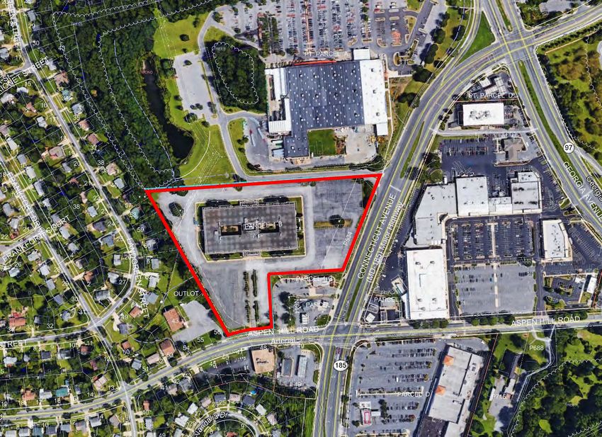
18Architecture and Elevations
The main façade will face Connecticut Avenue and will have a prominent view from the intersection of
Aspen Hill Road and Connecticut Avenue. The site will create a gateway feature at the Home Depot
shared access drive. A portion of the building will be constructed of modules stacked up to 4 stories
(approximately 60 feet above grade), and other modules which function optimally at 2 stories
(approximately 29 feet above grade). The modular construction system utilizes specifically sized
elements and connectors which facilitate the efficiency and speed of construction. The Garage will be 6-
stories tall, but with more conventional floor heights, and a combined height of approximately 60 feet
above grade.
Figure 14: Phase 1 Elevations
19Figure 15: Phase 2 Elevations
Transportation
The Applicant will construct frontage improvements, including a 10-foot sidepath with a 6-foot
landscaped buffer along both the Connecticut Avenue and Aspen Hill Road frontages. Along Connecticut
Avenue, the sidepath stretches from the northeast corner of the property southwest along the west side
of Connecticut Avenue. This stretch of sidepath extends past the boundaries of the subject property
and in front of the Dunkin Donuts and Shell Gas Station properties towards the intersection of
Connecticut Avenue with Aspen Hill Road.
20Figure 16: Connecticut Avenue Section
Along Aspen Hill Road, the sidepath begins at the southwest corner of the subject property and
stretches east in front of the Dunkin Donuts and Shell Gas Station properties. At the northeast corner of
the intersection of Aspen Hill Road and Connecticut Avenue, the two sidepaths tie into the existing
sidewalk. The sidepath could not be extended all the way to the corner due to existing utilities and
other site constraints.
Figure 17: Aspen Hill Road Section
Access to the site via Aspen Hill Road is restricted to Kaiser Permanente employees and emergency
personnel. An automated gate will be installed to prevent public access, along with signage marking the
entrance for employees. The access gate is situated approximately 100 feet north of the entrance to
Aspen Hill Road to provide internal queuing for employees accessing the site and prevent queuing on
Aspen Hill Road. This access point will be right-in, right-out only.
21Figure 18: Channelized Aspen Hill Access
The Applicant is proposing a full traffic signal at the intersection of Connecticut Avenue and the shared
driveway, including updated crosswalks, ADA accessible ramps, and median refuge islands. This traffic
signal is strongly supported by Planning Staff and MCDOT and has been approved by the Maryland State
Highway Administration. More detail regarding the traffic signal is included in the Transportation section.
Figure 19: Proposed New Signal Location
22Community Outreach
The Applicant has met all proper signage, noticing and pre-submission meeting requirements for the
submitted Applications. Staff has received emails and calls from residents on the proposed
development. Planning Staff has heard directly from Aspen Hill Civic Association (AHCA) and the Aspen
Hill Advocates. The major concern is the number of trips that will utilize the entrance on Aspen Hill
Road.
The prior approval limited the Aspen Hill Road entrance/exit for employees and emergency services only
and directed the majority of traffic to the Site’s Connecticut Avenue entrance. Similarly, the Applicant
has committed to limiting the Aspen Hill Road access to an “employee only” entrance. Furthermore, as
conditioned, the Aspen Hill Road access will be channelized to eliminate left-turns into the site and
provide for safer vehicular movement on Aspen Hill Road. Also, Planning Staff determined the truck
deliveries must access from Connecticut Avenue, as conditioned per Certified Site Plan No. 12.f. See
Attachment 4 for additional correspondence from the community and response from the Applicant.
SECTION 4: PROJECT ANALYSIS AND FINDINGS
Preliminary Plan No. 1202000130
Under Section 50.4.2.D, the Planning Board must make the following findings to approve a Preliminary
Plan:
1. The layout of the subdivision, including size, width, shape, orientation and diversity of lots, and
location and design of roads is appropriate for the subdivision given its location and the type of
development or use contemplated and the applicable requirements of Chapter 59.
The lots have been reviewed for compliance with Section 50-29(a) of the Subdivision Regulations. The
layout of the subdivision, including size, width, shape, and orientation of the lot continue to be
appropriate for their location within the subdivision and meet all applicable requirements of the CRT
Zone.
a. The Preliminary Plan provides for required public sites and adequate open areas.
The Project provides all required master plan 10’ sidepath along the property’s frontage and no
additional dedication was required for future public infrastructure. The Project establishes the minimum
10% public open space per each phase.
b. The Lot(s) and Use comply with the basic requirements of Chapter 59.
The consolidation lots were reviewed for compliance with the dimensional requirements for the CRT zone
as specified in the Zoning Ordinance. The lot as proposed will meet all the dimensional requirements for
area, frontage, width, and setbacks in that zone. A summary of this review is included in Table 1.
2. The Preliminary Plan substantially conforms to the Sector Plan or Urban Renewal Plan
The 2015 Aspen Hill Minor Master Plan Amendment (Master Plan) acknowledges the changing office
market in the area, and recommends zoning to allow redevelopment that includes a neighborhood-
serving mix of uses and activate the Connecticut Avenue corridor. The Master Plan also provides specific
design criteria to support “the transition of this area to a more pedestrian-friendly, accessible, and human-
scale environment.” (p. 13)
23The long-term goal of the Master Plan is to facilitate comprehensive redevelopment, it recognizes the
near-term likelihood of single-use redevelopment in transitional areas such as this commercial cluster.
The Medical Center does not satisfy the long-term vision of a mixed-use development, however many of
the human-scale and pedestrian-friendly design elements are met through the proposal.
• Public Realm: The Public realm along Aspen Hill Road will be improved with additional plantings,
and the existing sidewalk will be expanded to become a sidepath (10 feet wide) extending to
Connecticut Avenue. The existing sidewalk along Connecticut Avenue will be replaced with a
greenspace buffer (6 feet wide), a two-way sidepath (10 feet wide), and a pedestrian sidewalk (8
feet wide).
• Building Placement: The Medical Center buildings are placed towards the south east of the
Property. Building heights are concentrated along Connecticut Avenue and decrease from
Connecticut Avenue moving west towards the existing single family neighborhoods.
• Public Amenities: In addition to the Medical Center, the Property includes an event space
community plaza, an outdoor area for mindfulness and fitness activities, a nature trail with
exercise equipment, and a native plant, flower and herb garden in the middle of the Property.
• Building Entrances: The main entrance is located on Connecticut Avenue for people walking,
biking or taking transit. The entrance includes landscaping and seating which are visible and
accessible from Connecticut Avenue. The existing access from Aspen Hill Road will be gated and
available only for emergency use and employees. Visitors traveling by car to the Medical Center
will access the Property through the shared drive aisle with Home Depot.
• Vision Zero: In addition to the bikeway and sidewalk improvements, the project will provide a
new traffic signal and pedestrian facilities at the shared drive aisle and Connecticut Avenue,
which was identified in the Master Plan.
Although the proposal does not fully advance the goal of a walkable mixed-use neighborhood center
envisioned by the Master Plan, it does begin to provide the pedestrian and bicycle improvements and
public amenities. This application delivers a prominent new building which will enhance the Property’s
general appearance, mobility improvement along its frontages for pedestrians and cyclists, and public
amenities. Thus, these improvements are found to be in substantial conformance with the Master Plan.
Sector/Master-Planned Roadway and Bikeway
Connecticut Avenue is classified as a Major Highway, M-7, by the 1994 Aspen Hill Master Plan, with a
recommended 150-foot right-of-way. The Applicant is providing the required dedication to expand the
landscaped zone and construct the sidepath. Aspen Hill Road west of Connecticut Avenue is classified as
an Arterial, A-38, by the 1994 Aspen Hill Master Plan, with a recommended 80-foot right-of-way. No
additional dedication is required along Aspen Hill Road. The 2018 Bicycle Master Plan recommends a
two-way separated bike lane on the west side of Connecticut Avenue and a sidepath on the north side
of Aspen Hill Road.
The Preliminary Plan substantially conforms to the 2015 Aspen Hill Minor Master Plan Amendment, the
2018 Bicycle Master Plan, and the 2018 Master Plan of Highways and Transitways.
3. Public Facilities will be adequate to support and service the area of the subdivision
50-4.3.J.5 - APF Extension request for Phase 2
The Application is requesting a phased approval, per Section 50-4.3.J.5 to extend the validity period of
the APF approval for Phase 2 to 10 years. Per Sections 50-4.3.J.5.b, “if an applicant requests a longer
24validity period than the minimum specified in 5.a, the applicant must submit a development schedule or
phasing plan for completion of the project to the Board for its approval.”
i. At a minimum, the proposed development schedule or phasing plan must show the minimum
percentage of the project that the applicant expects to complete in the first 5 or 7 years,
whichever is the applicable minimum, after the preliminary plan is approved.
The Application is proposing to construct 72 percent of the total development for Phase 1 (130,000 sq.
ft.) within the first 5 years. This includes all frontage improvements along Aspen Hill Road and
Connecticut Avenue, and the onsite amenities shown on the Site Plan. The APF approval for Phase 2 that
is subject to the extension request, to allow the building permit to be filed for Phase 2 (which is 28
percent of total constructions) within 10 years of the Preliminary Plan approval.
ii. To allow a validity period longer than the specified minimum, the Board must find that the size
or complexity of the subdivision warrant the extended validity period and would not be adverse
to the public interest. The Board must condition a validity period longer than the specified
minimum on adherence to the proposed development schedule or phasing plan, and may
impose other improvements or mitigation conditions if those conditions are needed to assure
adequate levels of transportation or school service during the validity period.
Due to the complexity of developing Medical Offices the applicant needs this additional time for Phase 2
to justify the need for growth and allocate funding. The Project will meet the motor vehicle adequacy
tests for both Phases. Because it will generate fewer than 50 new pedestrian trips, new non-motorized
trips, and new transit trips, the Project is exempt from reviewing these systems for adequacy and no off-
site improvements are required. However, as previously stated the Applicant is proposing a 10-foot wide
sidepath long the property’s frontage and a new traffic signal as a part of Phase 1. Therefore, the project
will not adversely impact the public’s interest.
Recommendation
Planning Staff recommends the Planning Board approve the APF validity period to 10 years, based on
the finding outline within this staff report, per Section 50-4.3.J.5.
Vehicular Site Access Point and Circulation
The site is accessible from Connecticut Avenue and Aspen Hill Road. Vehicular access to the site from
Connecticut Avenue is available via a shared driveway north of the site, which also provides access to
The Home Depot. Access to the site via Aspen Hill Road is restricted to Kaiser Permanente employees
and emergency personnel. An automated gate will be installed to prevent public access. The access gate
is situated approximately 100 feet north of the entrance to Aspen Hill Road to provide internal queuing
for employees accessing the site and prevent queuing on Aspen Hill Road.
The Applicant is proposing a full traffic signal at the intersection of Connecticut Avenue and the shared
driveway, including updated crosswalks, ADA accessible ramps, and median refuge islands. This traffic
signal is strongly supported by Planning staff and MCDOT, will better regulate vehicular access onto the
site for patients and visitors, and enhances pedestrian safety at the intersection. The Applicant
completed a signal warrant analysis to assess the feasibility of a traffic signal at this location. Six
vehicular volume warrants are met under the existing conditions and the proposed future conditions
(Phase 1). The Maryland State Highway Administration (MDSHA) reviewed the signal warrant analysis
and approved the installation of the traffic signal. The Applicant will design and construct the new signal
25but must coordinate with MDSHA to determine the ultimate cycle length and submit a Design Request
for the proposed traffic signal location.
Tightening vehicle turning radii is recommended in the 2019 Aspen Hill Vision Zero Study. To slow
vehicle turning movements and shorten crossing distances for pedestrians, the curb radii at the
entrance from Aspen Hill Road are reduced to 20 feet and the curb radii at the intersection with
Connecticut Avenue are reduced to 25 feet.
Parking
On-site parking is provided in four surface parking lots for Phase 1; a structured parking garage will be
constructed on the northeastern surface parking lot to accommodate increased parking demands
associated with Phase 2 of the development.
The Applicant is requesting adequate parking to accommodate its members, staff, and the community
members, who are invited to use the amenities on-site. Although a Parking Waiver was included with
the original application to provide more than the allowed maximum number of parking spaces (which
is a ratio of 4.0 spaces per 1,000 square feet of building area), a parking waiver is not necessary
because the additional spaces are not limited or restricted in their use. Therefore, the Project will
provide 542 spaces for Phase 1 (a ratio of 4.2 spaces per 1,000 square feet), and 846 spaces for Phase
2 (a ratio of 4.7 spaces per 1,000 square feet). These parking ratios will allow for adequate employees
and members/patients to park on the Property without encroaching on the neighborhood.
Public Transit Service
Four local bus routes operate along Connecticut Avenue and Aspen Hill Road adjacent to the site:
• Ride On Route 26: Operates Monday-Sunday between the Glenmont Metro Station and the
Montgomery Mall Transit Center, with intermediate stops at the Twinbrook Metro Station, White
Flint Metro Station, and Rock Spring.
• Ride On Route 34: Operates Monday-Sunday between Bel Pre Road and Friendship Heights Metro
Station, with intermediate stops at the Bethesda Metro Station, Medical Center Metro Station,
Kensington, Wheaton Metro Station, and along Veirs Mill Road.
• Ride On Route 41: Operates Monday-Sunday between the Glenmont Metro Station and Bel Pre
Road, operating primarily along Connecticut Avenue.
• Metrobus L8: Operates Monday-Sunday between Aspen Hill Road and Friendship Heights Metro
Station, with stops in Kensington, Chevy Chase Lake, and Chevy Chase Circle, operating primarily on
Connecticut Avenue.
The existing Ride On/Metrobus stop on the west side of Connecticut Avenue is being moved
approximately 300 feet north to be located closer to the new traffic signal on Connecticut Avenue.
Pedestrian and Bicycle Facilities
Aspen Hill is designated as a Bicycle Pedestrian Priority Area (BiPPA), where the enhancement of bicycle
or pedestrian traffic is a priority. As such, the Applicant is providing a 10-foot sidepath and a 6-foot
landscaped buffer along the site’s frontage with Connecticut Avenue and Aspen Hill Road. The sidepath
on Connecticut Avenue is designed to be converted to a two-way separated bike lane at a later date, as
recommended by the 2018 Bicycle Master Plan. The sidepath will be extended along the Shell gas
26station frontage to the intersection of Aspen Hill Road and Connecticut Avenue, within the MDSHA right-
of-way.
An internal sidewalk network (6-feet wide) along the primary north/south driveway, the shared
driveway with Home Depot, and along the south side of Phase 1 provides safe pedestrian access within
the site. Crosswalks are provided where all sidewalks cross drive aisles or connect through parking lots
and along the main entrance loop, to facilitate access from the parking lot into the facility.
The site is providing 41 bicycle parking spaces, 32 long-term and nine short term. Short-term bike
parking is located along the building’s main entrance loop and adjacent to the long-term bike lockers on
the southeast side of the site. Additionally, runnels are provided on both staircases leading from
Connecticut Avenue to allow bicycles to better navigate the grade change.
Local Area Transportation Review
Per the 2016-2020 Local Area Transportation Review Guidelines, a traffic study is required to satisfy the
motor vehicle adequacy analysis if the proposed use generates more than 50-person trips within the
weekday peak hours. As the total number of peak-hour vehicle trips serving the site exceeds 50 trips per
peak hour, the Applicant was required to complete the motor vehicle system adequacy test, including a
traffic impact study (TIS). The pedestrian, bicycle, and transit adequacy analysis were not triggered for
this project.
Vehicle trip generation for the site was analyzed using the ITE Trip Generation Rates for Medical Office
Building and adjusted based on the mode split assumptions for the Aspen Hill Policy Area. The site is
replacing an existing office building and will generate a marginally higher number of trips in Phase 1, and
a substantially higher number of trips following the completion of Phase 2. In Phase 1, the site is
projected to generate 372 person trips during the AM peak hour and 594 person trips during the PM
peak hour. Compared to the existing office building, this is an increase of only nine person trips in the
AM peak period. In Phase 2, the site is projected to generate 496 person trips during the AM peak hour
and 824 during the PM peak hour. As detailed below, vehicular delays at study intersections are not
exceeded during the PM peak period.
Peak Period Auto Driver Auto Passenger Pedestrian* Transit Bicycle Person Trips
Phase 1
AM 276 68 28 11 17 372
PM 441 108 45 17 28 594
Phase 2
AM 369 90 37 14 23 496
PM 611 150 63 24 39 824
*Pedestrian trips are the sum of all transit and bicycle trips generated by the project
The traffic impact study analyzed 13 nearby intersections. The Aspen Hill Policy Area is a yellow policy
area, which applies the critical lane volume (CLV) level of standard for study intersections with a CLV of
271,350 or less; the Highway Capacity Manual (HCM) delay-based level of service standards is used to
analyze signalized intersections with a CLV of more than 1,350. Of the 13 intersections analyzed, two
exceeded the 1,350 threshold and were analyzed by HCM delay: Connecticut Avenue / Aspen Hill Road
(AM peak period) and Georgia Avenue / Bel Pre Road (AM peak period). The HCM congestion standard
for intersections within the Aspen Hill Policy Area is 59 seconds. Based on the results of the HCM
analysis, the Connecticut Avenue / Aspen Hill Road intersection exceeds the policy area congestion
standard of 59 seconds in the AM peak period of the future conditions. The Applicant proposed signal
timing adjustments that will mitigate the site’s vehicular impact and reduce delay at the intersection
below the policy area threshold. However, these signal timing adjustments were not accepted by
MCDOT. Per the LATR Guidelines, pedestrian and bicycle improvements qualify as mitigation when the
policy area congestion standard is exceeded. To satisfy the LATR test, the Applicant is extending the
sidepath off-site on both Connecticut Avenue and Aspen Hill Road. These improvements will prioritize
bicycle and pedestrian movement, as stipulated by Aspen Hill’s BiPPA designation. The intersection of
Georgia Avenue / Bel Pre Road does not exceed the policy area threshold and no mitigation is required.
Intersection Existing Background Phase 1 Future Phase 2 Future
Conditions Conditions Conditions Conditions
AM PM AM PM AM PM AM PM
Connecticut Avenue / Aspen 61.1 -- 61.5 -- 70.4 -- 72.9 --
Hill Road
Signal timing -- -- -- -- 53.6 -- 54.8 --
modifications
Georgia Avenue / 57.1 -- 57.3 -- -- -- 58.3 --
Bel Pre Road
HCM delay shown as seconds; HCM delay standard for Aspen Hill Policy Area is 59 seconds
Transportation Demand Management
In accordance with Montgomery County’s recently adopted countywide transportation demand
management legislation, the Applicant must implement a Level 1 Basic Plan for Phase 1, and upgrade to
a Level 2 Action Plan following the completion of Phase 2:
Level 1 Basic Plan must implement County-led strategies at the Project and must include:
1. Appoint a Transportation Coordinator and Commitment to Cooperate the Department’s
Programs – includes assistance include distribution of information on commuting options,
coordinating with the Department to conduct commuting-related outreach, participation in
commuter survey.
2. Notification – Each owner of a project is required to notify the Department in writing within 30
days of receipt of final U & O certificate from the Department of Permitting Services and
communicate change in Transportation Coordinator’s contact information.
3. Access to the Project - provide space in the project for the promotion of TDM;
4. TDM Information - display TDM-related information in highly visible location(s).
Level 2 Action Plans require of applicants/owners in Orange and Yellow Areas, all of the elements of
Level 1 plans, plus:
285. Selection of strategies to be implemented to achieve the NADMS goals (5% higher than the
District’s NADMS goal).
6. Commitment to fund and implement the Plan.
7. Self-Monitoring to determine if the Project-based TDM Plan is contributing toward
achievement of the District’s goals.
8. Committing funding to implement the specific actions.
9. Biennial Report – must be provided to the County in alternating years.
10. Addition and/or Substitution of Strategies – if the strategies initially selected have not
made progress towards the goal by four years after the date of final occupancy.
11. Additional Funding Commitment – if the project still has not made progress towards the
goal within 6 years after final occupancy.
12. Performance Incentives - the owner may be eligible for annual performance incentives
established by MCDOT for continued contribution over multiple years toward achievement
of commuting goals, including reductions in TDM fees or other financial benefits, as
established in the Executive Regulation.
This approval must be obtained from MCDOT prior to issuance of any building permit by the
Department of Permitting Services.
Other Public Facilities
The proposed development will be served by public water and sewer systems. Fire and Rescue has
reviewed the application and has determined that the Property has appropriate access for fire and
rescue vehicles. Other public facilities and services including police stations and health care will continue
to be sufficient following the construction of the project. Electric, gas and telecommunications services
will also be available.
4. All Forest Conservation Law, Chapter 22A requirements are satisfied
Environmental Guidelines
Staff approved Natural Resources Inventory/Forest Stand Delineation (NRI/FSD) #420200710 on
December 10, 2019. The approximately 10.03-acre Property is currently developed with a two-story
office building and associated asphalt surface parking lots. There are no forest or streams on-site but
there is an engineered floodplain associated with an off-site stormwater management facility. All
proposed structures are outside of the floodplain and associated 25’ Building Restriction Line (BRL). The
proposed plan is in conformance with the Environmental Guidelines.
Final Forest Conservation Plan
The Applicant has submitted a Final Forest Conservation Plan (FFCP) with the Preliminary Plan and Site
Plan. This FFCP amends FFCP #SC2020011, approved with the sediment control plan associated with the
demolition of the existing development. The forest conservation requirements of 1.68 acres were met in
an off-site mitigation bank as a part of the approval of FFCP #SC2020011. The FFCP shows the proposed
development and all disturbance necessary for development. As submitted, and including approval of
the accompanying variance request, the plan complies with Chapter 22A, Forest Conservation.
Due to the engineered floodplain being associated with an off-site stormwater management pond that
would occur in the event of a breach, Planning Staff is not establishing a conservation easement, per
Section 22A-12(b)(2).
29Variance
Section 22A-12(b)(3) of Montgomery County Forest Conservation Law provides criteria that identify
certain individual trees as high priority for retention and protection. Any impact to these trees,
including removal of the subject tree or disturbance within the tree’s critical root zone (CRZ) requires a
variance. An applicant for a variance must provide certain written information in support of the
required findings in accordance with Section 22A-21 of the County Forest Conservation Law. The law
requires no impact to trees that: measure 30 inches or greater, DBH; are part of a historic site or
designated with a historic structure; are designated as a national, State, or County champion tree; are at
least 75 percent of the diameter of the current State champion tree of that species; or trees, shrubs, or
plants that are designated as Federal or State rare, threatened, or endangered species. The Applicant
submitted a variance request on April 1, 2020 to impact one (1) tree, tree #12, that is considered a high
priority for retention under Section 22A-12(b) (3) of the County Forest Conservation Law. The submitted
variance request missed one additional tree (# 1) which is a specimen tree proposed to be impacted, but
not removed. Tree #1 is a 35” White Mulberry in poor condition with 31% impacts to its critical root
zone (CRZ). Tree #12 is a 57” White Oak that is located off-site. The variance request indicates that tree
#12 will have a 3.51% impact to its CRZ. However, the last iteration of plan has removed the disturbance
that would impact tree #12. A corrected variance request adding the impacts to tree # 1 must be
submitted prior to approval of the Certified Preliminary Plan.
Unwarranted Hardship
Tree #1 is located on the western property line, adjacent to the existing parking lot. The CRZ for tree #1
is currently impacted by this parking lot. The Applicant has proposed a walking path with fitness
equipment along the western property line. The Applicant would not be able to construct this path
without impacting the CRZ of tree #1. Thus, the Applicant has a sufficient unwarranted hardship to
consider a variance request.
Section 22A-21 of the County Forest Conservation Law sets forth the findings that must be made by the
Planning Board or Planning Director, as appropriate, in order for a variance to be granted.
Variance Findings
1. Will not confer on the applicant a special privilege that would be denied to other applicants.
As noted above, the Applicant cannot construct the fitness path improvements along
the western property line without the approval of this variance. Thus, granting the
variance will not confer a special privilege on the Applicant.
2. Is not based on conditions or circumstances which are the result of the actions by the
applicant.
The requested variance is based on the locations of the tree, rather than on conditions
or circumstances which are the result of actions by the Applicant.
3. Is not based on a condition relating to land or building use, either permitted or non-
conforming, on a neighboring property.
The requested variance is a result of the need to provide a fitness path and not a result
of land or building use on a neighboring property.
304. Will not violate State water quality standards or cause measurable degradation in water
quality.
The Applicant has minimized the impacts on trees by restraining the disturbance
necessary to construct the fitness path. No variance trees are proposed for removal
therefore no mitigation is required for these impacts. The project will not violate State
water quality standards or cause measurable degradation in water quality.
Variance Recommendation
Staff recommends that the variance be granted.
5. All stormwater management, water quality plan, and floodplain requirements of Chapter 19 are
satisfied.
The Applicant received approval of their stormwater management concept from the Montgomery
County Department of Permitting Services, Water Resources Section on June 15, 2020. The concept
meets required stormwater management goals using a combination of ESD approaches including rain
gardens, permeable paving, and microbioretention areas. The Property is not subject to a water quality
plan, and there are no floodplain requirements. The requirements of Chapter 19 for stormwater
management are satisfied.
6. Any other applicable provisions specific to the property and necessary for approval of the subdivision
is satisfied.
No other provisions apply to the Subdivision. (Need to address street grid per Sector Plan
recommendations).
Site Plan No. 82018007A Findings
Per Section 7.3.4 of the Zoning Ordinance,
1. When reviewing an application, the approval findings apply only to the site covered by the
application.
2. To approve a site plan, the Planning Board must find that the proposed development:
a. satisfies any previous approval that applies to the site;
Per the conditions of approval, the Applicant must satisfy and comply with all aspect of the
concurrent approval for the Preliminary Plan No 120200130. All conditions of prior approved per
Site Plan No. 820180070 are no longer valid and are superseded by the conditions established in
this Staff Report.
b. satisfies under Section 7.7.1.B.5 the binding elements of any development plan or schematic
development plan in effect on October 29, 2014;
This section is not applicable.
31c. satisfies under Section 7.7.1.B.5 any green area requirement in effect on October 29, 2014 for a
property where the zoning classification on October 29, 2014 was the result of a Local Map
Amendment;
This section is not applicable.
d. satisfies applicable use standards, development standards, and general requirements under this
Chapter;
Build-to-Area (BTA) Waiver
The Site Plan Application includes two waivers to modify or exceed the Zoning Ordinance, Chapter 59,
including the Build-to-Area front setback from Connecticut Avenue along the eastern boundary of the
property (Section 59-4.5.3.C.3.b) and screening requirement along the northern boundary adjacent to
the Home Depot property that is zoned R-90 (Sections 59-6.2.9.C.3.b.):
Per 59-4.5.3.C.3.b. The Build-to Area requirements may be modified by the Planning Board
during site plan review under Section 7.3.4. In approving a site plan submitted under this
subsection, the Planning Board must find that the plan: (1) deviates from the Build-to Area
requirements only to the extent necessary to accommodate the physical constraints of the site or
the proposed land use; and (2) incorporates design elements that engage the surrounding
publicly accessible spaces such as streets, sidewalks, and parks.
The Applicant is requesting relief from the 20-foot max required setback from to 35 feet and the
Building in front street BTA of 70% to zero (0)%. This is due to the physical constraints and topography of
the site, which has significant grade difference from the Property along Connecticut Avenue (see figures
19-21); and the angled frontage that makes the modular construction design inefficient, if required to
align the building frontage with Connecticut Avenue; to create the Medical Center, the building front
print must be placed at right angles. Also, to achieve a slope that complies with ADA requirements,
ramped approaches from the pedestrian level along Connecticut Avenue will require a substantial
setback. In addition, the eastern boundary of the Property along Connecticut Avenue must
accommodate the Master Plan 10-foot sidepath and 6-foot greenspace buffer. Planning Staff supports
the relief to the BTA due to site constraints.
32You can also read