Strategic Beach Management Plan: Panhandle Gulf Coast Region - Division of Water Resource Management Florida Department of Environmental ...
←
→
Page content transcription
If your browser does not render page correctly, please read the page content below
Strategic Beach Management Plan:
      Panhandle Gulf Coast Region
   Division of Water Resource Management
Florida Department of Environmental Protection
                  May 2018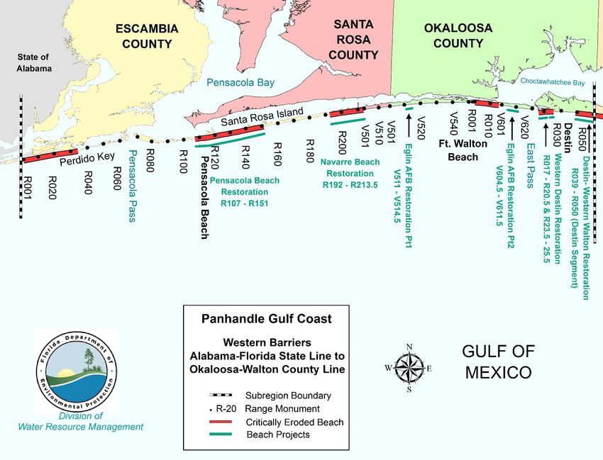
Florida Department of Environmental Protection, Strategic Beach Management Plan – Panhandle Gulf Coast Region

Table of Contents
INTRODUCTION - PANHANDLE ........................................................................................................ 1
WESTERN BARRIERS ........................................................................................................................... 2
       Strategies for Inlets and Critically Eroded Beaches .......................................................................... 2
       Perdido Key, Escambia County, R1-R34 .......................................................................................... 2
       Pensacola Pass, Escambia County, R67-R68 .................................................................................... 3
       Pensacola Beach, Escambia County, R107-R151.............................................................................. 4
       Navarre Beach, Santa Rosa County, R192.5-R213.5 ........................................................................ 5
       Okaloosa Island, Okaloosa County, R1-R15 ..................................................................................... 6
       East Pass (Choctawhatchee Bay Entrance), Okaloosa County, R17 ................................................. 7
       Norriego Point, Okaloosa County ...................................................................................................... 8
       West Destin, Okaloosa County, R17-R25.5 ...................................................................................... 8
       Destin, Okaloosa County, R39-R50................................................................................................... 9
       Regional Strategies for Beach and Inlet Management ..................................................................... 10
       Sponsors and Funding ...................................................................................................................... 10
       Project Coordination ........................................................................................................................ 10
       Environmental Protection ................................................................................................................ 11
       Sand Sources .................................................................................................................................... 11
       Innovative Projects........................................................................................................................... 11
       Additional Information .................................................................................................................... 12
       References ........................................................................................................................................ 14
PLEISTOCENE MAINLAND............................................................................................................... 17
       Strategies for Inlets and Critically Eroded Beaches ........................................................................ 17
       Area Wide Studies and Projects ....................................................................................................... 17
       Western Walton County (Reach 1), R1-R23.6 ................................................................................ 18
       C30A Corridor Beaches, Walton County (Reaches 2 -5), R41-R127.4 .......................................... 18
       Regional Strategies for Beach and Inlet Management ..................................................................... 20
       Sponsors and Funding ...................................................................................................................... 20
       Project Coordination ........................................................................................................................ 20
       Environmental Protection ................................................................................................................ 20
       Sand Sources .................................................................................................................................... 21
       Innovative Projects........................................................................................................................... 21

May 2018, Page i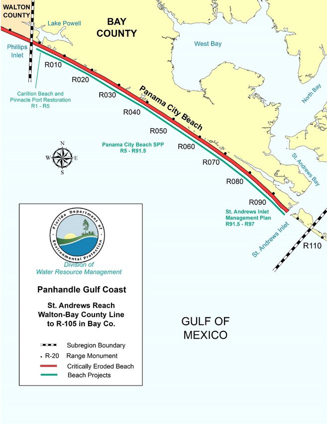
Florida Department of Environmental Protection, Strategic Beach Management Plan – Panhandle Gulf Coast Region
Additional Information .................................................................................................................... 21
References ........................................................................................................................................ 23
ST. ANDREWS REACH ........................................................................................................................ 25
Strategies for Inlets and Critically Eroded Beaches ........................................................................ 25
Panama City Beaches, Bay County, R1-R97 ................................................................................... 25
St. Andrews Inlet, Bay County, R97-R98 ....................................................................................... 27
Regional Strategies for Beach and Inlet Management ..................................................................... 28
Sponsors and Funding ...................................................................................................................... 28
Project Coordination ........................................................................................................................ 28
Environmental Protection ................................................................................................................ 29
Sand Sources .................................................................................................................................... 29
Additional Information .................................................................................................................... 29
References ........................................................................................................................................ 32
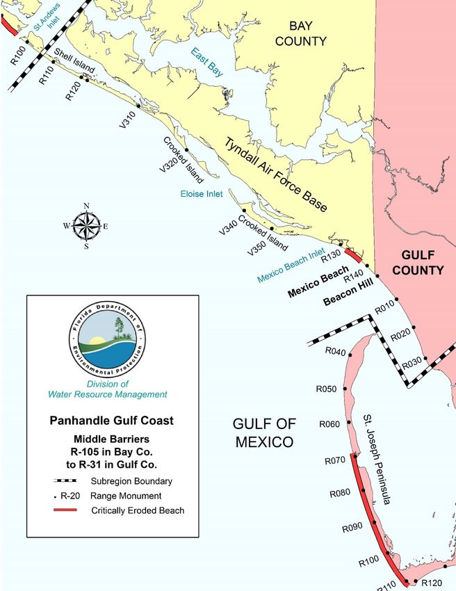
MIDDLE BARRIERS ............................................................................................................................ 34
Strategies for Inlets and Critically Eroded Beaches ........................................................................ 34
Eloise Inlet, Bay County .................................................................................................................. 34
Mexico Beach Inlet, Bay County ..................................................................................................... 35
Mexico Beach, Bay County, R132-R137.8 ..................................................................................... 35
Regional Strategies for Beach and Inlet Management ..................................................................... 36
Sponsors and Funding ...................................................................................................................... 36
Project Coordination ........................................................................................................................ 36
Environmental Protection ................................................................................................................ 36
Sand Sources .................................................................................................................................... 36
Additional Information .................................................................................................................... 37
References ........................................................................................................................................ 39
SAN BLAS REALIGNMENT ............................................................................................................... 41
Strategies for Inlets and Critically Eroded Beaches ........................................................................ 41
St. Joseph Bay Entrance Channel, Gulf County .............................................................................. 41
St. Joseph Peninsula, Gulf County, R69-R106 ................................................................................ 42
Cape San Blas, Gulf County, R106-R111.5 .................................................................................... 42
Regional Strategies for Beach and Inlet Management ..................................................................... 43
Sponsors and Funding ...................................................................................................................... 43
Project Coordination ........................................................................................................................ 43
May 2018, Page ii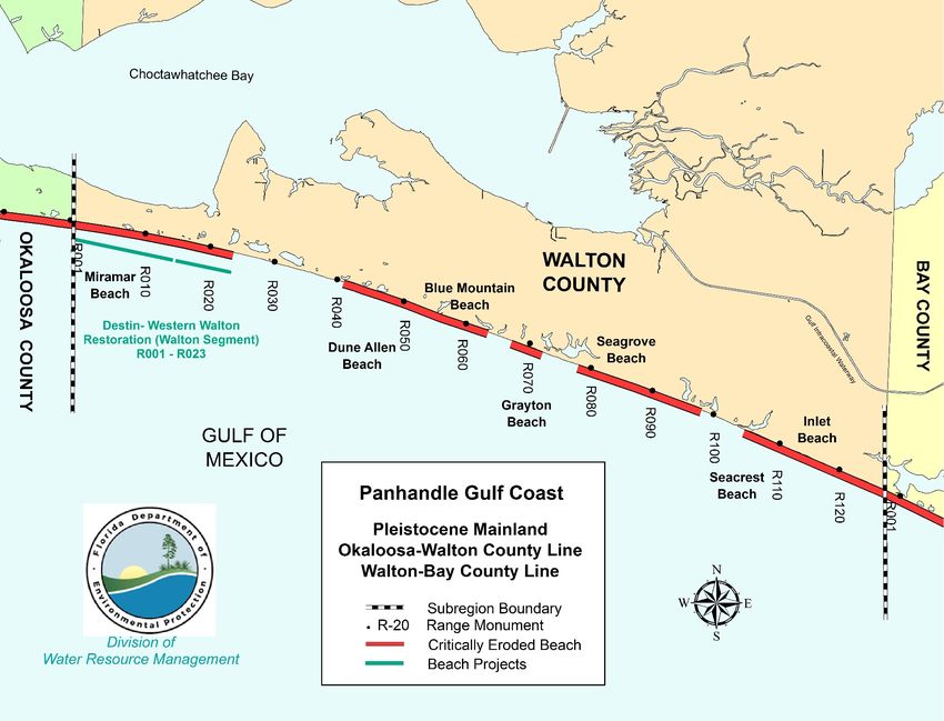
Florida Department of Environmental Protection, Strategic Beach Management Plan – Panhandle Gulf Coast Region

       Environmental Protection ................................................................................................................ 43
       Sand Sources .................................................................................................................................... 44
       Additional Information .................................................................................................................... 44
       References ........................................................................................................................................ 46
APALACHICOLA BARRIERS ............................................................................................................ 48
       Strategies for Inlets and Critically Eroded Beaches ........................................................................ 48
       Indian Pass, Gulf County, R160-V1 ................................................................................................ 48
       St. Vincent Island, Franklin County, V34-V39 ............................................................................... 48
       West Pass, Franklin County, V42-R1 .............................................................................................. 49
       Cape St. George, Franklin County, R18.5-R22.5 ............................................................................ 49
       Bob Sikes Cut, Franklin County, R51-52 ........................................................................................ 49
       St. George Island, Franklin County, R106-R128.5 .......................................................................... 50
       East Pass, Franklin County, R149-151 ............................................................................................ 50
       Dog Island, Franklin County, R168-R187.2 .................................................................................... 51
       Regional Strategies for Beach and Inlet Management ..................................................................... 51
       Sponsors and Funding ...................................................................................................................... 51
       Project Coordination ........................................................................................................................ 51
       Environmental Protection ................................................................................................................ 51
       Sand Sources .................................................................................................................................... 52
       Additional Information .................................................................................................................... 52
       References ........................................................................................................................................ 54
OCHLOCKONEE BARRIERS............................................................................................................. 56
       Strategies for Inlets and Critically Eroded Beaches ........................................................................ 56
       Area Wide Projects .......................................................................................................................... 56
       Alligator Point (Southwest Cape), Franklin County, R210-R216 ................................................... 56
       Lighthouse Point, Franklin County, R220-R222 ............................................................................. 57
       Mashes Sands County Park, Wakulla County ................................................................................. 57
       Shell Point, Wakulla County............................................................................................................ 58
       Regional Strategies for Beach and Inlet Management ..................................................................... 58
       Sponsors and Funding ...................................................................................................................... 58
       Project Coordination ........................................................................................................................ 58
       Environmental Protection ................................................................................................................ 59
       Sand Sources .................................................................................................................................... 59

May 2018, Page iii
Florida Department of Environmental Protection, Strategic Beach Management Plan – Panhandle Gulf Coast Region

       Additional Information .................................................................................................................... 59
       References ........................................................................................................................................ 61
  Appendix - Acronyms ............................................................................................................................. i

May 2018, Page iv
Florida Department of Environmental Protection, Strategic Beach Management Plan – Panhandle Gulf Coast Region

         Completed Navarre Beach Nourishment Project in September 2016. Photo courtesy of
         Michael Walther, P.E.

May 2018, Page v
Florida Department of Environmental Protection, Strategic Beach Management Plan – Panhandle Gulf Coast Region

INTRODUCTION - PANHANDLE

The Panhandle Gulf Coast Region has a total of 237 miles of beaches of which 84.3 miles are
critically eroded and 51.7 miles are actively managed. There are also 12 inlets/passes within the
Panhandle Gulf Coast Region and one of those passes has an inlet management plan - East Pass in
Okaloosa County. For additional beach management or project information, see the current Critically
Eroded Beaches Report, the joint coastal permits by county or the local government funding requests by
County. Each subregion listed below will have the introductory paragraph listing miles of coastline and
erosional events/ storms that have affected the subregion.

Each title within the subregion will list the coastal location, the county and the Department reference or
range (R) monuments for the critical erosion area. For inlets, river entrances or passes; the title, the
county and the adjacent range survey markers will be stated. In addition, there will be a subregion map
highlighting the critical erosion areas and the managed project areas. Finally, references to coastal
reports will be listed at the end of each subregion.

For additional information concerning projects or strategies along Florida’s coastline, see the following
links for the other six coastal regions of Florida and for background information, see the Strategic Beach
Management Plan’s Introduction.

        Strategic Beach Management Plan’s Introduction
        Northeast Atlantic Coast Region
        Central Atlantic Coast Region
        Southeast Atlantic Coast Region
        Florida Keys Region
        Southwest Gulf Coast Region
        Big Bend Gulf Coast Region
For additional information pertaining to beach and ocean conditions, coastal associations, educational
institutions or government agencies, see the following related coastal sites.
The State of Florida was significantly impacted by three hurricanes, Hermine, Matthew and Irma during
the 2016 and 2017 Atlantic Hurricane Seasons. To see additional information for strategies and funding
to address recovery for the beaches and dunes, see the “Hurricane Damage Assessment Report for 2016:
Florida’s Beaches and Dunes”. For the 2017 Hurricane season, see the “Hurricane Irma Post-Storm
Beach Conditions and Coastal Impact in Florida” report. The post-storm survey data has been fully
analyzed and an updated list of critically eroded beaches is in the Critically Eroded Beaches Report.

May 2018, Page 1 of 62
Florida Department of Environmental Protection, Strategic Beach Management Plan – Panhandle Gulf Coast Region

WESTERN BARRIERS

There are 67.8 miles of beaches in the Western Barriers subregion, which extends from the Florida-
Alabama state line in Escambia County to the Okaloosa-Walton County line, as shown on Figure 1.
There is a total of 25.3 miles of critically eroded beaches in this subregion (14.7 miles in Escambia
County, 4.1 miles in Santa Rosa County, and 6.5 miles in Okaloosa County), of which 16.4 miles have
been restored.

Erosion is attributed to tropical storms, hurricanes, and the effects of the inlets, including Pensacola Pass
and East Pass (Choctawhatchee Bay Entrance). The most erosive storms in recent years were Hurricane
Frederic (1979), Hurricane Elena and Tropical Storm Juan (1985), Hurricanes Erin and Opal (1995),
Hurricane Georges (1998), Tropical Storm Isidore (2002), Hurricane Ivan (2004), Hurricanes Dennis
(2005), Hurricane Katrina (2005), Hurricane Rita (2005), Tropical Storm Ida (2009), Hurricane Gustav
(2008), Tropical Storm Debby (2012), Hurricane Isaac (2012) and Hurricane Nate (2017).

In 1995, Hurricane Opal caused extensive erosion throughout northwest Florida. Using federal and state
disaster funds, a program of assisted recovery for the beach and dune system was conducted where
upland developed property was left vulnerable to storms. Sand was trucked from upland borrow sites,
placed in an alongshore berm configuration, and stabilized with wood slat sand fence and plantings of
sea oats. However, the beach and dunes had not fully recovered when Hurricane Georges impacted the
area in 1998, causing additional damage that required a second phase of assisted recovery of the most
eroded developed areas.

In 2004, Hurricane Ivan caused extensive erosion throughout northwest Florida. In Escambia County,
this erosion was even more severe than that caused by Opal. In 2005, Hurricanes Dennis, Katrina, and
Rita exacerbated erosion conditions throughout northwest Florida. As is described below, recovery
efforts like those implemented after Opal have been completed.

STRATEGIES FOR INLETS AND CRITICALLY ERODED BEACHES

PERDIDO KEY, ESCAMBIA COUNTY, R1-R34

This is a 6.5-mile segment of critically eroded beach on Perdido Key. Assisted recovery of the beach
and dune system was conducted following Hurricanes Opal, Georges, Ivan, and Dennis. Following the
effects of the 2004 hurricane season, emergency protective berms were constructed using funds from

May 2018, Page 2 of 62
Florida Department of Environmental Protection, Strategic Beach Management Plan – Panhandle Gulf Coast Region

FEMA. A dune restoration project to supplement these emergency protective berms with additional
sand and vegetation was performed in 2005-2006. A feasibility study to determine the appropriate
beach management strategy for this area was initiated in 2005 and completed in 2006, along with a sand
search study. The feasibility study recommended beach restoration. The Perdido Key Beach - Dune
Restoration Project proposed to place approximately 1.25 million cubic yards (mcy) of beach quality
sand in three different segments from an offshore borrow site. Construction is expected to begin in
2017/2018. The first segment is 2.4 miles long (R1-R12.5) and will construct a dune restoration project
with vegetation that will provide critical habitat for the Perdido Key beach mouse. The second segment
is 1.1-mile long (R12.5-R19) and will construct a protective berm within the Perdido Key State Park.
The third segment is three miles long (R19-R34) and will construct both a beach and dune restoration
project. As a separate component, the Perdido Key Dune Restoration Project is listed as an early
restoration project in the Deepwater Horizon Oil Spill: Programmatic and Phase III Early Restoration
Plan and Early Restoration Programmatic Environmental Impact Statement. The project was selected by
the Deepwater Horizon Natural Resource Damage Assessment (NRDA) Trustees for implementation.
The Perdido Key Dune Restoration project will restore dune vegetation to approximately 20 acres of
beach dune habitat. Currently, it is expected that only the third segment will be constructed in
2017/2018 with placement of approximately 1.05 million cy between R-19 and R-34. The Lower
Pensacola Harbor Maintenance Dredging project concluded in December 2016 by placing
approximately 238,000 cy of harbor material in the nearshore between R32 to R64 of Perdido Key.

Strategy: Beach and/or dune restoration; maintenance of the project through monitoring and
nourishment.

PENSACOLA PASS, ESCAMBIA COUNTY, R67-R68

Pensacola Pass, separating Perdido Key and Santa Rosa Island, includes the federal Pensacola Harbor
Navigation Project and provides access to the Pensacola Naval Air Station, the Port of Pensacola, and
the federal Gulf Intracoastal Waterway. In 1881, the authorized channel was dredged to a depth of               -
24 ft (MLW). It was incrementally deepened to -35 ft (MLW) by 1958. Maintenance dredged material
was placed in an offshore disposal site. In 1959, the navigation channel was widened and deepened to
-37 ft MLW, with placement of the dredged material on Santa Rosa Island. Subsequently, maintenance
dredged material was placed in an offshore disposal site and once on Perdido Key (1985).

May 2018, Page 3 of 62
Florida Department of Environmental Protection, Strategic Beach Management Plan – Panhandle Gulf Coast Region

While the federally authorized dimensions of the channel are presently set at -35 ft by 500 ft, the
channel was widened and deepened to -48 ft to accommodate a Navy aircraft carrier in 1991. The
dredged material was placed on Perdido Key. The channel has filled at a rate of approximately 300,000
cubic yards (cy) annually, but still maintained a depth of - 40 ft in 1997. Periodic maintenance dredging
has been completed in 2002 with material being placed in nearshore areas. In 2006, a beneficial use
plan was developed by Escambia County and the Florida Department of Environmental Protection
(Department or DEP) for the material dredged from Pensacola Pass. The plan included an evaluation of
the adjacent shorelines, sediment quality, and sediment placement alternatives. The U.S. Army Corps of
Engineers (USACE) developed a plan in August of 2013 with a similar beneficial use program. The
USACE plans to perform maintenance dredging for the U.S. Navy to a depth of - 48 ft when federal
funding is available. The strategy listed below is based in part on an inlet management study that was
completed in 1999 and the need for more current data and an updated plan. Pensacola Pass was dredged
in the winter of 2011/ 2012 placing approximately 520,000 cy on the eastern most portion of Perdido
Key within the Gulf Islands National Seashore. The Lower Pensacola Harbor Maintenance Dredging
project concluded in December 2016 by placing approximately 238,000 cy of harbor material in the
nearshore between R32 to R64 of Perdido Key. The Pensacola Harbor Lower Federal Navigation
Channel pilot dredging project is being proposed for 2019 to place approximately 500,000 cy of channel
material in the nearshore/ swash zone between R31.5 to R44 that is located on the western 2.4 miles of
the Perdido Key Unit of the Gulf Islands National Seashore.

Strategy: Update the sediment budget and adopt an inlet management plan.

PENSACOLA BEACH, ESCAMBIA COUNTY, R107-R151

This is an 8.2-mile segment of critically eroded beach at Pensacola Beach on Santa Rosa Island.
Assisted recovery of the beach and dune system was conducted following Hurricanes Opal and Georges.
Initial construction of the Pensacola Beach Restoration Project (R107–R151) was completed in
September 2003 using 4.2 million cy of sand from a borrow site located about 3.5 miles offshore. The
project length spanned the full 8.2 miles with an average post-construction beach width of 191 ft. The
project design consists of a beach berm elevation of +8 ft to +6 ft NAVD 88 with a Gulfward slope at
1:15 into the water to protect the existing dune and upland development. The project incorporates a
marine turtle friendly design with an 8-year nourishment interval. See project history in Table 1.

May 2018, Page 4 of 62
Florida Department of Environmental Protection, Strategic Beach Management Plan – Panhandle Gulf Coast Region

This area was severely impacted by Hurricane Ivan in 2004 and further impacted by Hurricanes Dennis
and Katrina in 2005. The 8.2-mile beach nourishment project was completed February 2006, with dune
restoration completed in April 2006 that included vegetation. Approximately 2,909,300 cy of fill
material (2,348,000 cy by dredge and 561,300 cy of recovered storm overwash material) was placed
between R107 and R151 in 2006 with FEMA cost sharing in these efforts. The Pensacola Dune
Restoration Project in 2012, that consisted of planting dune vegetation and sand fencing for 4.2 miles
beginning 7.5 miles east of Pensacola Pass, was an early restoration project listed in the Deepwater
Horizon Oil Spill Phase I Early Restoration Plan and Environmental Assessment and was selected by the
Deepwater Horizon NRDA Trustees for implementation. Pensacola Beach was nourished again in
summer of 2016 with placement of approximately 1,855,100 cy of offshore material between R-107.5
and R-150.5. Dune restoration also occurred as part of the beach nourishment project with the
installation of 113,840 salt tolerant plants and sand fencing along the nourished shoreline, with
installation completed in 2017.

Table 1. Pensacola Beach Nourishment Project history.

       Date                                                        Project Location
                          Volume (cy)          Sand Source                                Length (mi.)
     Completed                                                    (by R monument)

     September
                           4,200,000              Offshore            R107-R151                 8.2
       2003

     April 2006            2,909,300              Offshore            R107-R151                 8.2

      September
                           1,855,100              Offshore          R107.5-R150.5               8.1
        2016

Strategy: Maintain the project through monitoring and nourishment.

NAVARRE BEACH, SANTA ROSA COUNTY, R192.5-R213.5

This is a 4.1-mile segment of critically eroded shoreline at Navarre Beach on Santa Rosa Island.
Assisted-recovery of the beach and dune system was conducted following Hurricanes Opal and Georges.
This area was severely impacted by Hurricane Ivan in 2004 and further impacted by Hurricanes Dennis
and Katrina in 2005.

May 2018, Page 5 of 62
Florida Department of Environmental Protection, Strategic Beach Management Plan – Panhandle Gulf Coast Region Initial construction of the Navarre Beach Restoration Project began in late March 2006 and was completed in November 2006. The initial sand placement along 4.1 miles or 21,668 ft of shoreline between R192.5 and R214 included approximately 2,952,899 cy of material to construct the beach and dune. The project also included a dune feature that consisted of additional sand and dune vegetation. The borrow area is located about 4 miles offshore. The project included replacement of emergency protective berms that were funded by FEMA. A small truck haul project in April of 2010 was constructed to partially address spreading losses on the west end of the project site. The 2010 interim truck haul project repaired a portion of the dune which was damaged by Hurricanes Gustav and Ike in 2008, by placement of approximately 11,881 cy of beach quality material from an upland borrow site. The project design did not include a typical fill taper when a construction easement was not granted for sand placement on the adjacent Gulf Islands National Seashore. Beach nourishment was completed in July of 2016, placing approximately 1,311,961 cy of material from an offshore borrow site along 4.1 miles between R-192 and R-213. FEMA will cost share on this beach nourishment project in response to damages sustained during Tropical Storm Debby and Hurricane Isaac. Strategy: Maintain the project through monitoring and nourishment. OKALOOSA ISLAND, OKALOOSA COUNTY, R1-R15 This is a 2.8-mile segment of critically eroded beach on Santa Rosa Island near the community of Ft Walton Beach. Assisted recovery of the beach and dune system was conducted following Hurricanes Opal and Georges. Following the effects of the 2004 hurricane season, emergency protective berms were constructed using funds from FEMA. A dune feature was constructed in May 2005 to supplement the emergency protective berms with additional sand and vegetation. A feasibility study from 2007 was accelerated following the 2004/ 2005 storms, and the County and Eglin Air Force Base developed a cooperative plan for beach restoration. The Department issued a Joint Coastal Permit (JCP) in February 2012 for construction of a restoration project using sand from an offshore borrow site located approximately 1.25 miles offshore of Santa Rosa Island and 2 miles west of East Pass. Following issuance of the Joint Coastal Permit, the Okaloosa County Board of County Commissioners voted to withdraw their participation and the project was not constructed. Okaloosa County has installed native dune vegetation and sand fencing to protect remaining dunes. May 2018, Page 6 of 62
Florida Department of Environmental Protection, Strategic Beach Management Plan – Panhandle Gulf Coast Region

Strategy: Construct beach restoration project; maintain through nourishment and monitoring.

EAST PASS (CHOCTAWHATCHEE BAY ENTRANCE), OKALOOSA COUNTY, R17

East Pass is the historical natural tidal connection between the Gulf of Mexico and Choctawhatchee Bay,
between Santa Rosa Island and Moreno Point at the City of Destin. East Pass is periodically dredged to
maintain the federal navigation project. Initial dredging of the navigation channel was completed in
1969 with two jetties. Maintenance dredging of the channel has been conducted about every 18 months.
The material dredged from the channel near the seaward ends of the jetty is placed within the surf zone
west of the inlet. The material dredged from the inlet throat has been placed at several locations,
including a scour hole near the spur on the east jetty, within protective sand dikes along the east and
west jetties, on Norriego Point, and on the beach at Eglin Air Force Base. In May 2006, approximately
50,000 cy of maintenance dredged beach quality material were truck hauled to the adjacent Holiday Isle
beach (R17-R22). Material dredged from the ebb shoal has been used as a borrow source for the post-
storm Destin-Western Walton Beach Restoration Project that was completed in 2007.

The Department adopted the East Pass Inlet Management Study Implementation Plan on June 8, 2000.
This plan was based upon recommendations and supporting data compiled in the study report, Inlet
Management Plan for East Pass to Choctawhatchee Bay (Taylor Engineering, Inc., 1999). The 2000
inlet management plan which specified that all inlet dredge material be placed west of the inlet, did not
provide for balancing the inlet sediment budget or extending the life of proximate beach restoration
projects. The plan was not consistent with Section 161.142, Florida Statutes (adopted in 2008), because
it did not ensure that the inlet dredge material was placed on adjacent eroding beaches. For these
reasons, a new study cost-shared between the City of Destin and the Department was conducted in 2010
to develop an updated sediment budget.

The Eglin Air Force Base Beach Restoration Project adjacent to East Pass was completed in June
2010 by placing approximately 729,570 cy of fill material on the beach within Reach 3 (V604.5-V611.5)
and approximately 265,190 cy of fill material was placed in Reach 1 (V511-V514.5).

The Department adopted the East Pass Inlet Management Implementation Plan on July 24, 2013. With
adoption of the new inlet management plan (IMP), all future inlet management activities shall be
consistent with the four strategies found in the updated inlet management plan.

May 2018, Page 7 of 62
Florida Department of Environmental Protection, Strategic Beach Management Plan – Panhandle Gulf Coast Region

Strategy: Implement a comprehensive beach and inlet hydrographic monitoring program; modify the
current inlet sand transfer protocol to permit the placement of inlet dredge material along the Gulf
beaches both to the east and to the west of the inlet; complete the stabilization of Norriego Point;
investigate availability and feasibility of supplemental inlet sediment excavation.

NORRIEGO POINT, OKALOOSA COUNTY

This is a 0.8-mile segment of critically eroded inlet shoreline of East Pass. Bulkheads armor the
southern portion of this shoreline and the undeveloped land on the north end has been maintained by the
placement of material dredged from the navigation channel. Several T-groins were installed by private
interests in 2004 to stabilize the shoreline on Norriego Point. Beach compatible sand was placed at
Norriego Point in 2014. The City of Destin received a Joint Coastal Permit (2013) to stabilize Norriego
Point. The proposed stabilization project includes repair and extension of the existing T-groins,
construction of 2 additional T-groins, construction of approximately 500 linear feet of harbor side
seawall, construction of approximately 400 ft of northwest end seawall and placement of beach
compatible sand to create a dune feature with dune vegetation. The project will also include recreational
features to increase public access to Norriego Point. The Norriego Point Restoration and Recreation
Project is an early restoration project that is listed in the Deepwater Horizon Oil Spill: Programmatic and
Phase III Early Restoration Plan and Early Restoration Programmatic Environmental Impact Statement
and was selected by the Deepwater Horizon NRDA Trustees for implementation. A modified joint
coastal permit/notice to proceed was issued in September 2017 for planned structures at the north end of
Norriego Point with dredged material from the harbor channel as fill to extend the point to its previous
length. Construction began in late 2017 and is expected to be completed by June 2018.

Strategy: Complete the Norriego Point stabilization project pursuant to the JCP permit as authorized by
the Department, and as called for in the adopted East Pass Inlet Management Plan (2013).

WEST DESTIN, OKALOOSA COUNTY, R17-R25.5

Following the 2005 hurricane season, the western 1.6 miles of Destin was designated as a critically
eroded beach. In 2006, 50,000 cy of East Pass channel maintenance dredge material were placed
between R17 and R22. A feasibility study that includes this area was completed in April 2003 and a
sand search was completed in 2007 to identify a suitable source of beach quality material. As a result of
severe erosion caused by Tropical Storm Ida, the West Destin Emergency Beach Nourishment Project

May 2018, Page 8 of 62
Florida Department of Environmental Protection, Strategic Beach Management Plan – Panhandle Gulf Coast Region

was constructed in September 2010. Approximately 138,437 cy of fill material was placed between
R17.2 and R19.8. Fill was obtained from an offshore borrow site.

The West Destin Beach Restoration Project was completed in February 2013. The project includes two
segments with a total fill placement of 634,292 cy. The west segment extends from the East Pass east
jetty eastward to R20.7 with a fill placement of 487,003 cy. The West Destin Emergency Beach
Nourishment Project area was located within this segment of the restoration project. The restoration
project’s eastern segment extends from the west property line of Sandpiper Cove near R23.5 to R25.5
with a fill placement of 147,289 cy. There is a 2,900-foot gap between the segments, which includes 18
single-family lots and three condominiums. The monitoring control area includes the gap between fill
segments and 4,900 ft east of the project. The next scheduled beach nourishment event is still to be
determined.

Strategy: Maintain the project through nourishment and monitoring.

DESTIN, OKALOOSA COUNTY, R39-R50

This is a 2.1-mile segment of critically eroded beach east of Henderson Beach State Park in Destin. This
segment is contiguous to another segment of critically eroded beach in western Walton County.
Assisted recovery of the beach and dune system was conducted following Hurricanes Opal and Georges.
Following the impact of Hurricane Ivan (2004) and Hurricane Dennis (2005), emergency protective
berms were constructed in 2006 using funds from FEMA. A dune restoration project was constructed in
2006 to supplement the emergency protective berms with additional sand and vegetation.

A portion of the Destin-Western Walton Beach Restoration Project was constructed in 2006 and
completed in January 2007 using sand from the ebb shoal of East Pass. The expected nourishment
interval of the project is 8 years. The project has a total length of 6.9 miles and extends from R39 in
Okaloosa County through R22.8 in Walton County. The beach berm design is 210 ft wide.
Approximately 1,900,000 cy of sand was placed in the Walton County segment of the project and
950,000 cy in the Destin segment. The next scheduled beach nourishment event is still to be
determined.

Strategy: Maintain the project through nourishment and monitoring.

May 2018, Page 9 of 62
Florida Department of Environmental Protection, Strategic Beach Management Plan – Panhandle Gulf Coast Region

REGIONAL STRATEGIES FOR BEACH AND INLET MANAGEMENT

SPONSORS AND FUNDING

This subregion contains the governmental entities of Escambia, Santa Rosa, and Okaloosa Counties; the
Santa Rosa Island Authority (Pensacola Beach); the City of Destin; Division of Recreation and Parks;
the USACE; the U.S. Department of the Interior (National Park Service); and the U.S. Air Force (Eglin
Air Force Base). Participants with the Department as local sponsors of beach management projects
include Santa Rosa and Okaloosa Counties, the Santa Rosa Island Authority, and the City of Destin.
Property on Santa Rosa Island is leased from the federal government and is subject to leaseholder
agreements. The Gulf Islands National Seashore, managed by the National Park Service, occupies a
large portion of Perdido Key and Santa Rosa Island. The Division of Recreation and Parks manages
coastal property at Perdido Key State Park and Henderson Beach State Park. The U.S. Department of
the Interior manages the Gulf Islands National Seashore and the U.S. Air Force is responsible for coastal
property within Eglin Air Force Base. Project cost estimates and schedules may be found in the Beach
Management Funding Assistance Program - Long Range Budget Plan.

The restoration projects listed below are early restoration projects selected by the Deepwater Horizon
Oil Spill Natural Resource Damage Assessment (NRDA) Trustees for implementation. See the latest
NRDA latest updates for the Deepwater Horizon projects (94 in Florida) and their interactive maps.

    •   Perdido Key Dune Restoration, (Phase III)

    •   Pensacola Dune Restoration, (Phase I)

    •   Norriego Point Restoration and Recreation Project, (Phase III)

PROJECT COORDINATION

Regionalization is the funding and coordination of multiple nourishment and inlet management activities
to take advantage of identifiable cost savings through economies of scale, reduced equipment
mobilization and demobilization costs, and elimination of duplicative administrative tasks. The Destin –
Western Walton Beach Restoration Project is an example of project coordination. Future opportunities
include:

        1. Placement of beach quality sand on adjacent beaches from maintenance of Pensacola Pass.

        2. Placement of beach quality sand on adjacent beaches from maintenance of East Pass.

May 2018, Page 10 of 62
Florida Department of Environmental Protection, Strategic Beach Management Plan – Panhandle Gulf Coast Region
3. Combining nourishment projects in the subregion.
ENVIRONMENTAL PROTECTION
The protection of marine turtles, beach mice and shorebirds and their habitat are primary environmental
concerns within this subregion. The endangered Gulf sturgeon is also an environmental concern at
Pensacola Pass and East Pass. The timing of construction activities has been restricted during the
marine turtle nesting season of May 1 through October 31, though exceptions have been approved by the
US Fish and Wildlife Service. Project design and method of construction are restricted to avoid or
minimize adverse impacts to the federally and state-listed species and their habitats. The Fort Pickens
Aquatic Preserve is located within the boundaries of the Gulf Islands National Seashore on eastern
Perdido Key and western Santa Rosa Island. Projects located within and near the aquatic preserve
boundaries require additional protection, including more stringent water quality standards than in non-
aquatic preserve waters, during permitting and construction to ensure preservation of the existing
conditions. This area of coastline along Perdido Key and Santa Rosa Island have been impacted by tar
balls from the Deepwater Horizon oil spill of 2010.
SAND SOURCES
Offshore sand sources sufficient to meet the expected needs of future projects in this subregion over the
next 15 years have not been identified. Some upland dredged material storage sites adjacent to the
Intracoastal Waterway may contain potentially usable beach quality sand. Most of these upland sites are
located in Bay and Gulf Counties and would have to be transported by barge or truck. It is
recommended by the Department that an offshore sand search be conducted for this subregion for the
purpose of beach nourishment. For additional information on sand sources, the Department manages a
database titled the Regional Offshore Sand Source Inventory (ROSSI).
INNOVATIVE PROJECTS
A porous (net) groin system was installed as an experiment on a segment of beach on Eglin Air Force
Base in November 2001. A third-party peer review of the results of this test program indicated that this
system did not meet the performance expectations and was not cost effective.
May 2018, Page 11 of 62Florida Department of Environmental Protection, Strategic Beach Management Plan – Panhandle Gulf Coast Region
ADDITIONAL INFORMATION
The introduction of the state’s Strategic Beach Management Plan provides additional background
information on the Department’s Beach Management Programs and includes overviews of:
• The principles and statutes followed to help guide the state’s management strategies
• Comprehensive list of Florida’s inlets
• The miles of critically eroded beaches under active management
• Statewide sand source studies
• Statewide monitoring programs
• Innovative technologies examined
• Basic suggestions for emergency response plan
May 2018, Page 12 of 62Florida Department of Environmental Protection, Strategic Beach Management Plan – Panhandle Gulf Coast Region
Figure 1. The Western Barriers subregion of the Panhandle region of Florida. View an interactive map or COASTS imagery.
May 2018, Page 13 of 62Florida Department of Environmental Protection, Strategic Beach Management Plan – Panhandle Gulf Coast Region
REFERENCES
Browder, A.E., Reilly, W.I., and Olsen, E.J., 2006. Pensacola Pass, FL Recommendations for Dredged
Material Disposal for the Proposed U.S. Navy Channel Dredging, Olsen Associates, Inc., 41p.
Browder, A.E., 2005. Pensacola Beach, Florida. 2003 Beach Restoration Project – Hurricane Dennis, 10
July 2005, Post-storm Monitoring Report, 52 p.
Browder, A.E., 2003. Pensacola Beach, Florida, 2003 Beach Restoration Project Post-Construction
Report.
Browder, A. E., and Dean, R. G., 1999., Pensacola Pass, Fl., Inlet Management Study, University of
Florida, Coastal and Oceanographic Engineering Department.
Clark, R.R., and LaGrone, J., 2006a. A Comparative Analysis of Hurricane Dennis and Other Recent
Hurricanes on the Coastal Communities of Northwest Florida, 19th National Conference on Beach
Preservation Technology, February 1-3, 2006, 19 p.
Clark, R.R., and LaGrone, J., 2006b. Hurricane Dennis & Hurricane Katrina – Final Report on 2005
Hurricane Season Impacts to Northwest Florida. Publication of the Bureau of Beaches and
Coastal Systems, April 2006, 116 p.
Coastal Planning & Engineering, Inc. 2010. City of Destin, Florida, East Pass Inlet Study & Management
Considerations, 87 p.
Coastal Technology Corporation, 2001, Navarre Beach Reconnaissance Level Geotechnical
Investigation.
Coastal Technology Corporation, 2000. Navarre Beach Management and Feasibility Study.
Deepwater Horizon Oil Spill, 2014: Programmatic and Phase III Early Restoration Plan and Early
Restoration Programmatic Environmental Impact Statement, June 2014, 225 p.
Dean, R.G., and Malakar, S., 2003. Independent Cost Analysis of Porous Groin Installations at Eglin Air
Force Base, Florida: Final Report, University of Florida, Department of Civil and Coastal
Engineering, July 2003, 32p.
May 2018, Page 14 of 62Florida Department of Environmental Protection, Strategic Beach Management Plan – Panhandle Gulf Coast Region
Florida Department of Environmental Protection. 2004 Hurricane Recovery Plan for Florida’s Beach
and Dune System, 65 p.
Florida Department of Environmental Protection, 2017. Critically Eroded Beaches in Florida, Division
of Water Resource Management, 89 p.
Florida Department of Environmental Protection, 2000. East Pass Inlet Management Study
Implementation Plan, June 2000, 8 p.
Florida Department of Environmental Protection, 2013. East Pass Inlet Management Implementation
Plan, July 2013, 15 p.
Leadon, M.E., Foster, E., Nguyen, N., Cook, G., Brantly, R., Clark, R., As-Salek, J., LaGrone, J., Koch,
J., Sanders, P., Fokes, B., Roberts, S., 2004. Hurricane Ivan: Beach and Dune Erosion and
Structural Damage Assessment and Post-Storm Recovery Plan for the Panhandle Coast of Florida,
Florida Department of Environmental Protection, Bureau of Beaches and Coastal Systems, 64 p.
Leadon, M.E., Clark, R.R., and Nguyen, N.T., 1999. Hurricane Earl and Hurricane Georges, Beach and
Dune Erosion and Structural Damage Assessment and Post-Storm Recovery Plan for the
Panhandle Coast of Florida, Florida Department of Environmental Protection, Bureau of Beaches
and Coastal Systems Report No. BCS-99-01, 43 p.
Leadon, M.E., Nguyen, N.T., and Clark, R.R., 1998. Hurricane Opal: Beach and Dune Erosion and
Structural Damage Along the Panhandle Coast of Florida, Florida Department of Environmental
Protection, Bureau of Beaches and Coastal Systems Report No. BCS-98-01, 102 p.
Olsen Associates, Inc., 2006. Perdido Key, FL Feasibility Study for Beach Restoration: Sand Search
Investigation. Report FL COA00003491.
Taylor Engineering, Inc., 1999. Inlet Management Plan for East Pass to Choctawhatchee Bay.
Taylor Engineering, Inc., 2003. Walton County/Destin Beach Management Feasibility Study.
Taylor Engineering, Inc., 2007. Okaloosa County Beach Management Feasibility Study.
Taylor Engineering, Inc., 2012. Eglin Air Force Base Beach Restoration Project, 2012 Two-Year Post
Construction Monitoring Report, Okaloosa County, FL., 59 p. plus appendices.
May 2018, Page 15 of 62Florida Department of Environmental Protection, Strategic Beach Management Plan – Panhandle Gulf Coast Region
U.S. Army Corps of Engineers, 1998. Water Resources Development in Florida.
U.S. Army Corps of Engineers, 2016. Water Resources Development in Florida
Wang P., Brutsche K., Beck T., Rosati J., Lillycrop L., 2013. Initial Morphologic Evolution of Perdido
Key Berm Nourishment, Florida, U.S. Army Corps of Engineers, 11 p.
May 2018, Page 16 of 62Florida Department of Environmental Protection, Strategic Beach Management Plan – Panhandle Gulf Coast Region PLEISTOCENE MAINLAND There are 25.6 miles of beaches in the Pleistocene Mainland subregion, which extends from the Okaloosa-Walton County line east to the Walton-Bay County line as shown on Figure 2. There are 14.3 miles of critically eroded beaches in this subregion, of which 5 miles have been restored and maintained. Erosion is attributed primarily to tropical storms and hurricanes. The most erosive storms in recent years were Hurricane Eloise (1975), Hurricane Opal (1995), Hurricane Georges (1998), Tropical Storm Isidore (2002), Hurricane Ivan (2004), Hurricanes Dennis and Katrina (2005) and Hurricane Nate (2017). In 1995, Hurricane Opal caused extensive erosion throughout the northwest Florida coast. Using federal and state disaster funds, a program of assisted recovery of the beach and dune system was conducted where upland developed property was left vulnerable to storms. Sand was trucked from upland borrow sites, placed in an alongshore berm configuration, and stabilized with wood slat sand fence and plantings of sea oats. However, the beach and dunes had not fully recovered when Hurricane Georges impacted the area in 1998 causing additional damage that required a second phase of assisted recovery of the most eroded developed areas. Tropical Storm Isidore (2002) and Hurricane Ivan (2004) caused additional extensive erosion throughout Walton County’s beaches and dunes. In 2005, Hurricanes Dennis, Katrina, and Rita exacerbated erosion conditions throughout Northwest Florida. STRATEGIES FOR INLETS AND CRITICALLY ERODED BEACHES AREA WIDE STUDIES AND PROJECTS The USACE initiated a county-wide federal feasibility study in 2004 to determine the appropriate beach management strategy. This work was supplemented by Walton County and the Department, and Walton County completed a state and local feasibility study in 2006. The USACE Civil Works Review Board reviewed the federal draft study in December 2012. The project reached a major milestone in July of 2013 with completion and approval of the feasibility study. The Walton County Hurricane and Storm Damage Reduction Project was authorized by Congress in 2014. Within the authorized project template, there are five designated critically eroded areas in Walton County that total 18.8 miles. The preliminary engineering and design (PED) was completed in January 2015 and construction was planned May 2018, Page 17 of 62
Florida Department of Environmental Protection, Strategic Beach Management Plan – Panhandle Gulf Coast Region

for 2016/2017. The Walton County Commission decided to postpone the Walton County Hurricane and
Storm Damage Reduction Project in March 2016.

Area wide strategy: Facilitate completion of the federal design and permitting activities; construct
beach restoration project; and perform a coastal geomorphology study of the coastal lakes and peat
formations for implications in future beach management measures.

WESTERN WALTON COUNTY (REACH 1), R1-R23.6

This is a 5.2-mile segment of critically eroded beach that includes unincorporated Miramar Beach,
Tang-O-Mar Beach, Gulf Pines, Sandestin, and Four Mile Village. This segment adjoins a segment of
critically eroded beach in Okaloosa County. This segment is the first reach of the Walton County
Hurricane and Storm Damage Reduction Project. Assisted recovery of the beach and dune system
within the most eroded developed areas was conducted following Hurricanes Opal and Georges.
Following Hurricane Ivan in 2004, emergency protective berms were constructed using funds from
FEMA. A dune restoration project was also completed in 2005 to supplement the emergency protective
berms with additional sand and vegetation. The Destin - Walton County Beach Restoration Project
(R1-R22.8) was completed in January 2007 using 1,900,000 cy of sand obtained from the ebb shoal of
East Pass, along with placement of 950,000 cy in the Destin segment in Okaloosa County. The next
scheduled beach nourishment event is still to be determined.

Strategy: Maintain the project through nourishment and monitoring.

C30A CORRIDOR BEACHES, WALTON COUNTY (REACHES 2 -5), R41-R127.4

Beach Highlands to Blue Mountain Beach (Reach 2) is a 4.5-mile segment of critically eroded beach
(R41-R64) that includes unincorporated Beach Highlands, Dune Allen Beach, and Blue Mountain Beach
that is part of the Walton County Hurricane and Storm Damage Reduction Project (5 Reaches).
The segment between R54.5 and R58 is designated critical for the design integrity of the Walton County
Hurricane and Storm Damage Reduction Project. The east end between R63 and R64 is designated
critical for the construction of a dune taper only to maintain design integrity of the Walton County
Hurricane and Storm Damage Reduction Project. Assisted recovery of the beach and dune system
within the most eroded developed areas was conducted following Hurricanes Opal and Georges.
Following the impact of Hurricane Ivan, emergency protective berms were constructed using funds from

May 2018, Page 18 of 62
Florida Department of Environmental Protection, Strategic Beach Management Plan – Panhandle Gulf Coast Region

FEMA. A dune restoration project was also completed in 2005 to supplement the emergency protective
berms with additional sand and vegetation.

Gulf Trace to Grayton Beach (Reach 3) is a 1.0-mile segment of critically eroded beach (R67-R72)
that includes unincorporated Gulf Trace and a 0.1-mile segment of Grayton Beach where development is
threatened by erosion. An additional 1,900-foot gap between the threatened areas, which contains
undeveloped park lands, has been added for continuity of management of the coastal system following
federal project authorization. Additionally, two segments (300 ft to the west and 500 ft to the east),
where no development exists seaward of the Coastal Construction Control Line (CCCL), has been added
for continuity of management of the coastal system following federal project authorization. Assisted
recovery of the beach and dune system within the most eroded developed areas was conducted following
Hurricanes Opal and Georges. This area was also heavily impacted by Hurricane Ivan in 2004.

WaterColor to Deer Lake (Reach 4) is a 3.9-mile segment of designated critically eroded beach (R78-
R98) that includes unincorporated Seagrove Beach. Critical erosion along 3.1-miles of Seagrove Beach
(R82-R98) threatens development. Along the western 4,000 ft of the segment, the developments of
Water Color and Seaside have been designated critically eroded for continuity of management of the
coastal system following federal project authorization, even though most of the development is behind
the CCCL. Assisted recovery of the beach and dune system within the most eroded developed areas was
conducted following Hurricanes Opal and Georges. This area was also heavily impacted by Hurricane
Ivan in 2004.

Seacrest Beach to Inlet Beach (Reach 5) is a 4.2-mile segment of designated critically eroded beach
(R105.5-R127.4) that includes unincorporated Seacrest Beach, a 1.8-mile segment (R105.5-R114.7)
where development is threatened by erosion of the bluff. To the east at Inlet Beach is a 1.0-mile
segment (R122-R127), including a portion where development is threatened by erosion between R122
and R124, and another portion between R124 and R127 that was designated critical for the design
integrity of the beach restoration project. Between R114.7 and R122 is a 1.4-mile gap between
threatened areas where nearly all of the development is completely landward of the CCCL. This area
and a 400-foot segment at the east end, where there is currently no development seaward of the CCCL,
were added for continuity of management of the coastal system following federal project authorization.

Assisted recovery of the beach and dune system within the most eroded developed areas was conducted
following Hurricanes Opal and Georges. Following the impact of Hurricane Ivan in 2004, emergency

May 2018, Page 19 of 62
You can also read