Improvements and Challenges Associated with the Facilitation of Road Transport in Viet Nam
←
→
Page content transcription
If your browser does not render page correctly, please read the page content below
Chapter          6
Improvements and Challenges Associated with the
Facilitation of Road Transport in Viet Nam

Nguyen Binh Giang

February 2019

This chapter should be cited as
Nguyen, B. G. (2019), ‘Improvements and Challenges Associated with the Facilitation of Road
Transport in Viet Nam’, in Ishida, M. (ed.), Cross-border Transport Facilitation in Inland ASEAN
and the ASEAN Economic Community, ERIA Research Project Report FY2017 no.18, Jakarta:
ERIA and IDE-JETRO, pp.165-191.
Chapter 6

  Improvements and Challenges Associated with the Facilitation of

                            Road Transport in Viet Nam

                                    Nguyen Binh Giang

While the recent road improvement in Viet Nam has facilitated transport and promoted local
investment, it has created additional challenges to drivers engaged in cross-border transport.
These challenges, in particular, are in terms of the toll charges and local governance.
Meanwhile, soft road infrastructure initiatives in Viet Nam such as road signs and road traffic
laws are generally similar to that of neighbouring countries. The downside, though, is that Viet
Nam still has a large number of these road traffic signs in Vietnamese than in English, the
language commonly found on road signs in other sections of the ASEAN Highway Network.
Signs written in the local language cannot help transit drivers from neighbouring countries in
terms of guidance on road regulations that may be new to them.

Introduction

Recently, Viet Nam has made sustained efforts to develop its transport infrastructure,
constructing expressways and upgrading and expanding important highways. In addition, road
signs have been aligned with the stipulations of the Vienna Convention on Road Traffic Signs.
Viet Nam is gradually replacing obsolete and unsuitable signs (particularly those limiting the
maximum speed to 50 km/h, as current road conditions and vehicles can now ensure safety at
higher speeds). Its provisions on technical standards for road transport vehicles in Viet Nam are
similar (and even less restrictive in certain cases) to those stipulated in the Association of
Southeast Asian Nations’ (ASEAN) Framework Agreement on the Facilitation of Goods in Transit
(AFAFGIT).

Meanwhile, in terms of traffic signs, Viet Nam’s Road Traffic Law is generally in line with the
stipulations of the Vienna Convention on Road Traffic.

                                              165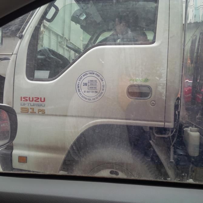
As part of the Greater Mekong Subregion, Viet Nam’s Road Traffic Law and road sign system are
comparable to those in other nations in this region. Similarities in their rules and regulations
have greatly facilitated cross-border road transport between Viet Nam, China, and other
ASEAN member states.

This chapter reviews recent developments in the road transport system in Viet Nam and
discusses the regulations on technical standards for road vehicles, the road sign system, road
traffic laws and their related legal documents, and the impact of such developments on the
country and the ASEAN region.

1. Recently Upgraded Sections of the Road Network in Viet Nam

In recent years, heavy investment has been made in the Vietnamese road network to ensure
both domestic and cross-border connectivity. However, the development of expressway
networks and upgrade of some crucial national highways (NH) remain sluggish. Viet Nam is
currently in the first phase of establishing expressway networks. New highway construction
projects on the Hanoi–Lao Cai, Hanoi–Hai Phong, Hanoi–Thai Nguyen, Nhat Tan–Noi Bai, Ho Chi
Minh–Long Thanh, and Ho Chi Minh–Ben Luc links have been completed, as has the upgrade
and widening of the Hanoi–Can Tho segment of National Highway No. 1 (NH1A, also AH1). At
the same time, segments of the North–South Expressway such as Hanoi–Ninh Binh, Long
Thanh–Dau Giay, and Ben Luc–Trung Luong have been constructed (Table 6.1). The upgrade
and widening of NH51 as well as the upgrade of the Ho Chi Minh Highway (NH14) have also
recently been completed.

                 Table 6.1. Status of North–South Expressway Development

              Section                 Length                        Status
Phap Van (Hanoi)–Cau Gie (Ha            29      In use as a four-lane expressway since 2011 and
Nam)                                            a six-lane since the mid of 2018. Connects to
                                                Hanoi–Hai Phong Expressway, Hanoi–Lao Cai
                                                Expressway, and NH1A via the Hanoi's Ring
                                                Road No. 3.
Cau Gie–Ninh Binh                       54      In use since June 2012.
Ninh Bình–Danang                      628.4     Awaiting further investment or start of

                                               166
construction.
Danang–Quang Ngai                        139     Under construction since May 2015
Quang Ngai–Dau Giay (Dong Nai)         807.5     Awaiting further investment or start of
                                                 construction
Dau Giay–Long Thanh (Dong Nai)            43     In use since February 2015. Connects to HCMC
                                                 (in Dist. 2)– Long Thanh Expressway.
Long Thanh–Ben Luc (Long An)              58     Under construction since July 2014.
Ben Luc–Trung Luong (Tien Giang)        39.8     In use since February 2010. Connects to HCMC
                                                 (in Binh Chanh District)–Ben Luc Expressway (in
                                                 use since February 2010).
Trung Luong–My Thuan Bridge–Can           92     Under construction since February 2015.
Tho
HCMC = Ho Chi Minh City
Source: Decision No. 140/QĐ-TTg of 21 October 2010 by the prime minister on the detailed plan on the
         North–South Expressway.
        Survey done by the author.

1.1 AH14 (Kunming–Hanoi–Hai Phong Corridor)

On 21 September 2014, the 244 km Noi Bai–Lao Cai Expressway, which is part of the Kunming–
Hanoi–Hai Phong Corridor (or ASEAN Highway AH14), was opened for use. The first stage of
construction was funded by ordinary capital resources and the Asian Development Fund, both
from the Asian Development Bank, as well as counterpart capital from the government of Viet
Nam.

In the past, vehicles traveling between Hanoi and Lao Cai had to use NH2 and NH70, resulting
in a journey close to 300 km. One month after the opening of Viet Nam's longest expressway,
the traffic flow on the new route averaged 8,000 vehicles a day. One year after the opening,
traffic flow reached 14,000 vehicles a day. Meanwhile, the traffic flow on NH70 decreased by
75%. Up to 96% of trucks and 79%

of cars changed their route from the highways to the expressway. Out of 24 transport service
providers on the expressway who were interviewed, 23 confirmed the benefit of the
expressway to their businesses. Most drivers interviewed reported that while they used to take
at least seven hours driving from Hanoi to Lao Cai along the highways, they now can reach their
destination via the new expressway in four hours. The expressway, thus, offers them a time
savings of three to four hours.

                                                167
They also save 10%–20% in fuel. A 12-ton truck requires a total cost of D3.49 million when
driven on the highways, but only D3.1 million when it uses the expressway. Meanwhile, buses
require a total cost of D3.47 million on the highways, but only D2.8 million on the expressway
(Tri, 2014). Thanks to the cost savings from the Hanoi–Lao Cai route, bus service providers
lowered the average bus fare from D370,000 to D220,000, which was a considerable benefit to
passengers.1 Ever since the opening of the expressway, the number of traffic accidents and
travellers on NH70 in Lao Cai Province has decreased by 80%.

Around the same period that the expressway was being constructed, Yen Bai Province
constructed the 10 km long and 50 m wide road connecting Yen Bai City with the expressway at
Interchange (IC) No. 12.

Previously, driving on the highway from Yen Bai City to Hanoi took 200 minutes; from Yen Bai
City to Hai Phong, 300 minutes; and from Yen Bai City to Lao Cai International Border, 200
minutes. Since the opening of the expressway, it now takes only 75 minutes from Yen Bai City
to Hanoi (a two-thirds decrease), 90 minutes to the Lao Cai Border, 150 minutes to Hai Phong
(along NH5, not the Hanoi–Hai Phong Expressway), 90 minutes to Bac Ninh City, and less than
120 minutes to Thai Nguyen City (Thanh Phuc, 2015).

The tourism industry in Lao Cai Province also grew rapidly since the opening of the expressway.
In 2015, 2.1 million tourists visited Lao Cai – a 39% increase compared with the 2014 figure and
a 235% jump from the 2010 numbers. Revenues from tourism in 2015 increased by 40% and
567% when compared with the 2014 and 2010 figures, respectively.2 A month after the
expressway’s opening, tourism in Sa Pa3 increased by 40%, reaching 2,000 to 3,000 people a
day. During weekends, the number of tourists reached 12,000 to 15,000 a day. Before the
expressway was opened, only about 23,000 people a week visited Sa Pa (Tri, 2014).

Similarly, a marked increase was seen in the number of visitors to Tay Thien (in Vinh Phuc)4,
Hung Kings Temple, Au Co Shrine (in Phu Tho)5, and Dong Cuong and Nhuoc Son Shrines (in Yen

1
  Per the document prepared by Lao Cai Province People's Committee for the meetings with Institute of
Developing Economies-Japan External Trade Organization and Institute of World Economics and Politics.
2
  Document prepared by Lao Cai Province People's Committee for the meetings with Institute of
Developing Economies-Japan External Trade Organization, and Institute of World Economics and
Politics.
3
  Sa Pa is a well-known ethnic and eco-tourism site in Lao Cai Province.
4
  Tay Thien is a well-known religious and eco-tourism site in Vinh Phuc Province.
5
  Hung Kings Temple is a place where the ancient founders of Vietnam can be worshipped.

                                                168
Bai).6 Phu Tho, Yen Bai, and Lao Cai jointly promoted the expressway to increase tourism in the
region.7

Since the opening of the expressway, sharp increases in investment in Phu Tho, Yen Bai, and
Lao Cai have been observed as well.8 In 2015, Phu Tho had 38 investment projects, including
10 foreign direct investment injections. Some of the largest amongst the 38 new investment
projects in Phu Tho included an electronic parts and components production project of Korea's
Joint National Training Capability (capital: US$50 million); a garment project by Japan's
Matsuoka (capital: US$75 million), and a chicken egg farm and factory project by DTK
Corporation (capital: D784 billion).9

Yen Bai attracted 29 projects. Some of largest of these projects in 2015 included a rabbit
breeding initiative by Nippon Zoki with a first-stage capital of US$78 million, a shopping mall
and real estate project by Vingroup with a capital of D685.3 billion, a 27-hole golf course and
resort development project by Chi Linh Star Golf with a capital of D630 billion, and an ox
breeding project by the Hoa Phat Group.10

However, the Noi Bai–Lao Cai Expressway also brought some negative impact to the
surrounding provinces. During a field survey on NH2 and NH70, the Institute of Developing
Economies–Japan External Trade Organization and the Institute of World Economics and
Politics team found that the people who live in towns and popular sites along the highway
were totally or partly dependent on income from the services they provided to vehicles and
passengers. Local communities along NH70 could have suffered a loss of income in such
services when vehicles switched to the expressway.11 The expressway disenfranchised local
communities in areas that it runs through.

The expressway itself was not spared from complaints. Many residents found the tunnels
under the expressway that serves communities to be small in size and insufficient in number,

6
   Document prepared by Yen Bai Province Department of Planning and Investment for the meeting with
Institute of Developing Economies-Japan External Trade Organization, and Institute of World Economics
and Politics on 21 January 2016.
7
   Yen Bai Province Department of Planning and Investment (2016).
8
   Documents prepared by the Phu Tho and Yen Bai Provinces’ Departments of Planning and Investment
and the Lao Cai Province People's Committee for the meetings with Institute of Developing
Economies-Japan External Trade Organization, and Institute of World Economics and Politics.
9
   Phu Tho Province People's Committee (2015), Evaluation of Socio-economic Development Tasks in the
Year 2015.
10
    Yen Bai Province Department of Planning and Investment (2016).
11
    Lao Cai Province People's Committee (2016).

                                                169
thereby limiting the movement of local people and goods.12 In addition, when the weight of
vehicles that transport materials to expressway construction sites had damaged local roads, no
rehabilitation projects have been carried out.13 During the field visit to sites, this study’s team
found many traffic signs to be either too old or fail to meet either the national technical
standards or the stipulations of the Vienna Convention on Road Traffic Signs.
The Hanoi–Hai Phong Expressway, which is 105.8 km long, connects Hanoi's Third Ring Road to
Dinh Vu Harbour in Hai Phong, and is the widest expressway in Viet Nam. It consists of six lanes
and two additional lanes for emergencies. It opened on 5 December 2015 after 6.5 years of
construction that was funded by the Vietnam Development Bank. Its traffic flow of 9,000
vehicles a day helps reduce the overcapacity in NH5. It also reduces the travel time from Hanoi
to Hai Phong to between one and 1.5 hours compared with the 2.5 hours along NH5 (Loan,
2014).
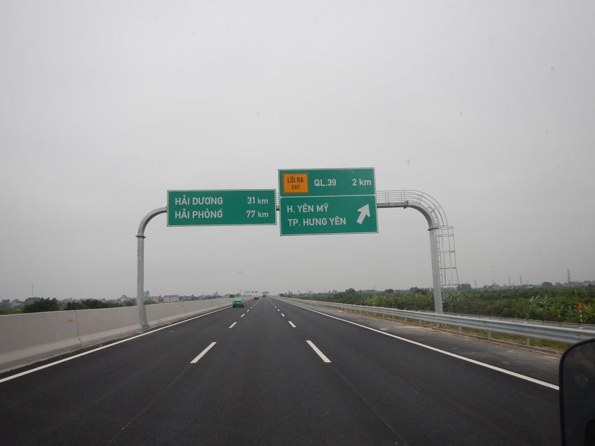
Figure 6.1. Example of Road Signs on the Hanoi–Hai Phong Expressway
Source: Photo taken by the author.
12
Yen Bai Province Department of Planning and Investment (2016).
13
Ibid.
1701.2 AH1
The AH1 in Viet Nam includes the national highways NH1A, which runs from North to South
Viet Nam, the North–South expressway, and NH22 in Southeastern Viet Nam.
The NH1A is the backbone route of the North–South transportation in Viet Nam, with the
Hanoi–Can Tho segment having the largest traffic flow. Before it was upgraded and widened,
almost all of the highway had only two lanes without a hard median strip. The road surface was
also heavily damaged. For these reasons, the travel speed on NH1A was very slow, and there
was a high rate of traffic accidents.
The upgrade and widening of NH1A started in 2011. The first 133 km segment between Hanoi
and Thanh Hoa was finished in 2013. The segment between Thanh Hoa and Can Tho was
completed at the end of December 2015, while the 45.8 km Hanoi–Bac Giang segment was
finished at the beginning of January 2016.
The NH1A project was primarily funded by the government of Viet Nam from government
bonds and partially funded through 17 build-operate-transfer (B-O-T) and build-transfer (B-T)
contracts.
The upgraded highway is classified as a Class III road, but features four automobile lanes and
two mixed lanes with a hard median strip. The 20.5 m wide road requires a speed limit of 80
km/h (or 60 km/h in heavy traffic areas). Therefore, it has characteristics of a Class II road,
based on Viet Nam's national technical road standards. The segment between Hanoi and Bac
Giang has six lanes and a speed limit of 100 km/h, similar to an expressway.
The NH1A upgrade project also includes the construction of several tunnels such as the Co Ma
and Cu Mong Tunnels between Phu Yen and Khanh Hoa, and the Phu Gia and Phuoc Tuong
Tunnels in Thua Thien–Hue, as well as the construction of dozens of new bridges.
The upgraded NH1A reduces the travel time between Hanoi and Ho Chi Minh City to 25–30
hours, representing a savings of 10 to 15 hours. In addition, the number of traffic accidents has
decreased considerably. However, some complaints have been received regarding the fee
applied to B-O-T segments (Hung, 2016). Some heavy trucks utilise local roads along NH1A to
avoid toll gates, which results in damages on these local roads (Giang, 2016).
The North–South Expressway runs parallel to the east of (and close to) NH1A. According to the
local (Ninh Binh) government, ever since the Hanoi–Ninh Binh segment of the North–South
171Expressway was opened in 2012, both the provincial gross domestic product and the tourism
industry have grown quickly. Thanks to improved transport, the number of tourists at sites such
as Trang An, Bai Dinh, and Tam Coc Bich Dong has increased considerably (Ministry of Transport,
2015). The expressway has also enhanced trade connectivity between Ninh Binh and Hanoi as
well as the surrounding provinces; facilitated travel and transport of humans and goods; and
reduced travel time, traffic accidents, and traffic congestions on NH1A.
Before the North–South expressway opened, it took more than two hours to travel by car
between Hanoi and Ninh Binh on NH1A. Today, however, the same trip takes just over an hour
via the expressway. Traveling on the expressway also reduces costs by 12% to 15% (when
compared to trips via NH1A).
Similarly, after the 35 km Thanh–Dau Giay opened in February 2015 and was linked to the 20
km Ho Chi Minh–Long Thanh Expressway, travel time between the Second Ring Road in District
2 of Ho Chi Minh City and Dau Giay has gone down to less than an hour. The old route, which is
via the 70 km-long Bien Hoa, takes about three hours to traverse due to frequent traffic jams.
1.3 AH131
In the second half of the 2000s, the government of Viet Nam improved some provincial roads
leading to NH12C to facilitate the flow of commercial traffic between the Vung Ang and Cha Lo
Border Economic Zones. From Vung Ang Port, the NH12C runs through Ky Anh, and the Tuyen
Hoa District to a Y-junction with the Ho Chi Minh Highway, where it also meets the NH12A,
which then runs to the Cha Lo Border Gate. The NH12C’s two-lane road imposes a speed limit
of 60 km/h for about half of its length, 40 km/h for a 24 km segment near the border, and 80
km/h on a segment that overlaps with NH1A near Vung Anh Port. The NH12C greatly reduces
the distance between Cha Lo and Vung Ang by about 37 km to 56.2 km.
1.4 AH17
The AH17 in Viet Nam includes NH14 and NH14B in Central Viet Nam, and NH13 and NH51 in
Southeastern Viet Nam.
The first 24 m segment of NH14B runs through Danang City and has four lanes, while the next
36 km segment has two lanes. The upgrade of 663 km of NH14 in Tay Nguyen (Central
172Highlands), financed by government bonds and B-O-T contracts, began in 2007, accelerated in
2014 and 2015, and was finished in June 2015. The entire route (outside of urban areas) has
two lanes for motor vehicles and two additional lanes for all kinds of vehicles and sets a speed
limit of 80 km/h. Some sections that run through urban areas expand to four lanes with a
speed limit of 60 km/h.
This upgraded highway allows vehicles to reduce fuel usage by 30% to 40% and real costs by
10% to 20%, in comparison to the pre-upgraded highway. It also helps reduce travel time
(Vietnam News Agency, 2015).
As another segment of AH17, the NH51 is a crucial route connecting Ho Chi Minh City, Binh
Duong, and Dong Nai with international sea ports. This highway was widened to four lanes in
1997. However, due to the development of new industrial parks, urban towns, and sea ports,
NH51 quickly became overpopulated. The highway had to be upgraded and widened into eight
lanes (six vehicle lanes and two mixed lanes) in 2009. It was completed in 2012 through funds
secured from B-O-T contracts.
The Ho Chi Minh–Long Thanh Expressway and the newly upgraded NH51 have reduced the
travel time from Ho Chi Minh City to Vung Tau from 150 minutes to 80 minutes, and the travel
distance from 120 km to 95 km. Travel costs also decreased by around 20% to 30%. An easing
in traffic congestion and reduction in accidents has also been observed (Cau Duong Viet Nam,
2015).
2. Technical Requirements for Vehicle Dimension
2.1 Driving Side
In Viet Nam, traffic keeps to the right. According to Viet Nam's Road Traffic Law of 2001:
Automobiles of proper types allowed to join in traffic must satisfy the following quality,
technical safety and environmental protection criteria:…Their steering wheels are on the
left side of the automobiles.
173The Road Traffic Law of 2008 also states:
The steering wheel is on the left side of the automobile; for a foreigner’s
overseas-registered automobile with a right-handed steering wheel to join the road traffic
in Viet Nam, it must comply with the Government’s regulations.
According to Government Decree No. 80/2009/ND-CP of 1 October 2009, the operation of
foreigners' overseas-registered right-hand drive cars in Viet Nam should be governed by the
follow rules:
• To observe Viet Nam's law on road traffic;
• To travel in groups with an escort vehicle only along designated routes and with the
Ministry of Transport's prior written approval. Organisations and individuals introducing
right-hand drive cars in Viet Nam shall arrange for escort vehicles and ensure traffic
safety when these vehicles run within the Vietnamese territory.
Because China, Lao PDR, Cambodia, and Myanmar follow the same left-hand rule, their
vehicles will cause no issues on Viet Nam’s roads. However, drivers from Thailand will find
disparities in driving practices and rules and difficulties in obtaining an approval from
Vietnamese authorities.
2.2 Weight and Load of Vehicles
Until recently, the limit in the sizes of vehicles was regulated by the Ministry of Transport's
Circular Nos. 07/2010/TT-BGTVT, 03/2011/TT-BGTVT, and 65/2013/TT-BGTVT. Amongst their
stipulated limits are:
1) Axle loads:
a) Single axle: Axle load ≤ 10 tons/axle.
b) Dual-axle cluster (2 axles), depending on the distance (d) between the two axle centres:
• If d < 1.0 m, then load of axle unit ≤ 11 tons;
• If 1.0 m ≤ d < 1.3 m, then load of axle unit ≤ 16 tons;
• If d ≥ 1.3 m, then load of axle unit ≤ 18 tons.
174c) Triple-axle units (3 axles), depends on the distance (d) between the two adjacent axle
centres:
• If d ≤ 1.3 m, then load of axle unit ≤ 21 tons;
• If d > 1.3 m, then load of axle unit ≤ 24 tons.
2) Total weight of vehicles:
a) For unibody vehicles
• When the total axles equal two, the total vehicle weight ≤ 16 tons;
• When the total axles equal three, the total vehicle weight ≤ 24 tons;
• When the total axles equal four, the total vehicle weight ≤ 30 tons;
• When the total axles equal five or more, the total vehicle weight ≤ 34 tons;
b) For combination tractors with trailers or semi-trailers
• When the total axles equal three, the total vehicle weight ≤ 26 tons;
• With the total axles equal four, the total vehicle weight ≤ 34 tons;
• With the total axles equal five, the total vehicle weight ≤ 44 tons;
• With the total axles equal six or more, the total vehicle weight ≤ 48 tons.
c) For the combination of unibody vehicles pulling trailers or semi-trailers
• The total weight of combination vehicles includes the total weight of the unibody
vehicle and the total axle load of pulled trailers and semi-trailers. The total weight
should not exceed 45 tons.
Today, however, the axle load limits are defined by the new Circular 46/2015/TT-BGTVT (in
effect since 1 December 2015). Its stipulations regarding axle load are the same as that in the
superseded circulars, to wit:
(1) Axle load:
a) Single axle: Axle load ≤ 10 tons/axle.
b) Dual-axle cluster (2 axles), depends on the distance (d) between the two centres of
axles:
• If d < 1.0 m, then load of axle unit ≤ 11 tons;
• If 1.0 m ≤ d < 1.3 m, then load of axle unit ≤ 16 tons;
• If d ≤ 1.3 m, then load of axle unit ≤ 18 tons.
175c) Triple-axle units (three axles), depends on the distance (d) between the two adjacent
centres of axles:
• If d ≤ 1.3 m, then load of axle unit ≤ 21 tons;
• If d > 1.3 m, then load of axle unit ≤ 24 tons.
However, the new circular now stipulates that the total weight limit of a unibody vehicle that
has five or more axles should depend on the distance between its first axle and the last axle
(Item 2a below).
For combination tractors with trailers or semi-trailers with either five or six axles, the revised
total weight limit now depends on the distances between the centre of the coupling pin and
the centre of the first axle of each semi-trailer (Item 3b).
For combination unibody vehicles pulling trailers and semi-trailers, the load limit requirements
differ under the criteria ‘trailer’ and ‘semi-trailer’. The revised stipulations are underscored
below.
(2) The total weight of the vehicle:
a) For unibody vehicles
• When the total axles equal two, the total vehicle weight ≤ 16 tons;
• When the total axles equal three the total vehicle weight ≤ 24 tons;
• When the total axles equal four, the total vehicle weight ≤ 30 tons;
• When the total axles equal five or more at the same time, the distance from the
centre of the first axle to the centre of last axle:
+ Less than or equal to 7 m, the total vehicle weight ≤ 32 tons;
+ Longer than 7 m, the total vehicle weight ≤ 34 tons.
b) For combination tractors with trailers or semi-trailers
• When the total axles equal three, the total vehicle weight ≤ 26 tons;
• When the total axles equal four, the total vehicle weight ≤ 34 tons;
• When the total axles equal five and the distance between the centre of coupling pin
and the centre of the first axle of semi-trailers:
+ From 3.2 m to 4.5 m, the total weight of combination vehicles ≤ 38 tons;
176+ Longer than 4.5 m, the total weight of combination vehicles ≤ 42 tons.
• With the total axles equal six or more and the distance between the centre of
coupling pin and the centre of the first axle of semi-trailers:
+ From 3.2 m to 4.5 m, the total weight of combination vehicles ≤ 40 tons; when
carrying only one container, the total weight of combination vehicles ≤ 42 tons;
+ Longer than 4.5 m, but not longer than 6.5 m, the total weight of combination
vehicles ≤ 44 tons;
+ Longer than 6.5 m, the total weight of combination vehicles ≤ 48 tons.
c) For the combination of unibody vehicles pulling trailers: The total weight of
combination vehicles includes the total weight of the unibody vehicle and total axle
load of pulled trailers. The total weight allowed should not exceed 45 tons.
d) The total weight has to be reduced by 2 tons for each metre of length shortened for the
following combination vehicles: (i) For unibody vehicles pulling semi-trailers: If the
distance between the centre of coupling pin and the centre of the first axle of
semi-trailers is shorter than 3.2 m; (ii) For unibody vehicles pulling a one-axle trailer: If
the distance between the centre of the coupling pin and the centre of the axle of trailers
is shorter than 3.7 m; or (iii) For unibody vehicles pulling a multi-axle trailer: If the
distance between the centre of coupling pin and the centre of the first axle or the centre
of first axle cluster of the trailer is shorter than 3.0 m.
At Viet Nam's weigh stations, the method of checking the axle loads can be applied only if
there is no capacity to check the total weight of vehicles and cargo. When the vehicle includes
multi-axle clusters, the weigh station can choose the axle with largest load to check. The total
weight is the total of axle loads. If the total weight of the vehicle and its cargo is larger than the
allowed weight based on the above regulations, or if the axle load is 1.15 times larger than the
allowed axle load based on the same regulations, then the vehicle is not allowed to enter a
particular road.
2.3 Size Limit of Vehicles
According to the new Circular 46/2015/TT-BGTVT (Table 6.2), the size limit for vehicles should
be no longer than 20 m, no wider than 2.5 m, and no higher than 4.2 m, except for the
container trailer. (It is worth noting that the height limit on first- to third-class expressways or
177highways is 4.75 m, while that on fourth- or lower class highways is only 4.5 m).
Oversized cargo is defined as unbundled cargo where the total dimensions of both vehicles and
cargo are more than 20 m in length, 2.5 m in width, or 4.2 m in height (4.35 m in the case of
container trailers).
Table 6.2. Comparison of Technical Requirements on the Size Limit of Vehicles Between Viet
Nam and AFAFGIT
Viet Nam AFAFGIT
Maximum Length
(Rigid Motor Vehicle) 12.2 m
(Articulated Vehicle) 20 m 16.0 m
Maximum Width 2.5 m 2.5 m
Maximum Height 4.2 m 4.2 m
Maximum Number of Axles
Maximum Axle Load
(Single axle) 10 tons
(Dual axle cluster) 11–18 tons
(Three-axle cluster) 21–24 ton
Maximum Rear Axle Load ROH < 60% of WB
AFAFGIT = Association of Southeast Asian Nations Framework Agreement on the Facilitation of Goods in
Transit; ROH = rear overhang; WB = wheel base.
Source: Circular 46/2015/TT-BGTVT and AFAFGIT.
Overweight cargo is unbundled cargo where the total weight of the combination of vehicles
and cargo is more than 32 tons. Vehicles are permitted to carry oversized or overweight cargo
only with special permits from authorised agencies.
178Table 6.3. Comparison of Regulations on the Weight and Load of Vehicles Between Viet Nam
and AFAFGIT
Maximum Permissible Gross Vehicle Weight Viet Nam AFAFGIT
3-Axle Rigid Vehicle 24.0 tons 21.0 tons
4-Axle Rigid Vehicle 30.0 tons 25.0 tons
4-Axle Articulated Vehicle 34.0 tons 32.0 tons
5-Axle Articulated Vehicle 44.0 tons 36.0 tons
6-Axle Articulated Vehicle 48.0 tons 38.0 tons
AFAFGIT = Association of Southeast Asian Nations Framework Agreement on the Facilitation of Goods in
Transit.
Source: Circular 46/2015/TT-BGTVT and AFAFGIT.
3. Road Signs in Viet Nam
The first regulations for road signs were issued in 1984. These regulations were adopted from
that of the Soviet Union and China, which were generally based on the Vienna Convention. Viet
Nam revised its regulations in 1998, 2001, and 2006 (after the signing of the Greater Mekong
Subregion agreements). In May 2012, Viet Nam issued the National Technical Regulation on
Traffic Signs and Signals (QCVN 41:2012). This national standard was based on the Vienna
Convention, even though Viet Nam was not yet a member of the convention at that time.
In addition, Viet Nam issued its first regulations regarding expressway guide signs in July 2005,
and the National Technical Regulation on Expressway Guidance Signs (QCVN 83:2015/BGTVT)
in June 2015 (Figure 6.2). The nation is currently discussing plans to design new national
technical standards on both highway and expressway signs.
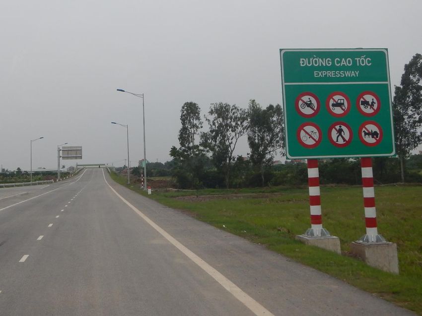
179Figure 6.2. Example of a Road Sign at the Entrance of the Hanoi–Hai Phong Expressway
Source: Photo taken by the author.
On 20 August 2014, Viet Nam officially became a member of the Vienna Convention on Road
Traffic as well as the Vienna Convention on Road Traffic Signs and Signals. It became the fourth
member of ASEAN to sign the conventions, after Indonesia, Thailand, and the Philippines; and
the second ASEAN member state to ratify the conventions, after the Philippines.
Road signs in Viet Nam are categorised into six types:
• Prohibitory signs. These have a circular shape, a wide red border, a white background,
and black symbols and inscriptions. Many prohibitory signs have red oblique downward
bars;
• Warning signs. These have a triangular shape, a wide red border, a yellow background,
and black symbols and inscriptions;
• Mandatory signs. These have a circular shape, no border, a blue background, and white
180symbols and inscriptions (except for signs indicating the direction in which vehicles
carrying dangerous goods should proceed, similar to sign D, 10 in the Vienna
Convention);
• Information signs. These have a rectangular or square shape, or a rectangular shape
with a blue background;
• Additional signs. These have a rectangular or square shape and are a combination of the
sign types above to provide additional information; and
• Signs for cross-border routes. These are similar to signs placed on domestic routes, but
the text is in English instead of Vietnamese. Most road signs are placed on red and white
poles on the right side of the road. Some are hung above the road or placed on a median
strip.
In addition, the 2012 regulations also set rules for kilometre markers. These markers are
upright cement poles with a white background and black text, except that their rounded tips
have white text on a red background. The white text indicates the name of the highway and
the distance to the other end of the highway. The black text indicates the name and distance
(in kilometres) of a destination ahead.
Viet Nam's signs for distance and speed are indicated in kilometres rather than miles. This
practice is similar to that in Lao PDR, Cambodia, Thailand, and China; thus, cross-border drivers
will not have problems navigating around these neighbouring nations. On the other hand,
drivers going inside Viet Nam from Myanmar might encounter some difficulty because
Myanmar residents are more familiar with miles as a unit for measuring distance.
Ever since the 2012 national standard was issued, Viet Nam has not been able to replace all of
its unsuitable traffic signs yet (Figure 6.3). While it managed to replace the signs along the
Asian Highway and almost all national highways, a number of unsuitable signs along other
routes have yet to be removed. Also, although the 2012 standards require signs to be set up on
cross-border routes along the Asian Highway, there is still a lack of road signs written in English.
In this chapter’s field study of the Noi Bai–Lao Cai Expressway (AH14), for example, many signs
warning of overhead electric cables featured text stipulating the safe height for vehicles, but
were written in Vietnamese only.
181Figure 6.3. Differences in Traffic Signs between Viet Nam’s 2001 and 2012 Regulations
Viet Nam's 22 TCN 237-01 (of 2001) QCVN 41:2012 (of 2012)
Sign
Number
401
402
202
Source: Ministerial Technical Regulation on Traffic Signs and Signals 22 TCN 237-01 and National
Technical Regulation on Traffic Signs and Signals QCVN 41:2012.
Another significant difference pertains to warning signs for level crossings. In Viet Nam, one
red bar indicates 50 metres, two bars mean 100 m, and three bars signify 150 m (See Sign No.
243 in Figure 6.4 as an example). In contrast, under the Vienna Convention, three bars indicate
300 m; two bars, 200 m; and one bar, 100 m. Regulations in Viet Nam also differ from those in
Lao PDR, where each bar indicates an incremental increase in distance of 80 m.
182Figure 6.4. Differences in Traffic Signs In Viet Nam’s 2012 Regulations and the Vienna
Convention
Viet Nam's QCVN 41:2012 Vienna Convention
sign number
247
214
211b
243
Source: National Technical Regulation on Traffic Signs and Signals QCVN 41:2012 and the Vienna
Convention on Road Signs.
1834. Road Traffic Laws
4.1 Outline of the Road Traffic Law
Viet Nam issued the first Road Traffic Law in 2001 (Law No. 26/2001/QH10) and the current
Road Traffic Law in 2008 (Law No. 23/2008/QH12). In drafting the 2008 version, the Ministry of
Transport reviewed and evaluated the implementation of the 2001 law and its accompanying
documents, as well as translated international laws and conventions on road transport.
The 2008 Road Traffic Law includes the following eight chapters and 89 articles:
• Chapter 1: General provisions. This chapter provides the scope of regulations,
application objects, interpretation of terms, operating principles.
• Chapter 2: Road traffic rules. This chapter covers aspects of road traffic rules such as
the road signalling system; observance of road signs, vehicle speed, and distance
between vehicles; use of lanes, passing, vehicle navigation; reversing; avoidance of
oncoming vehicles; parking on roads or streets; loading of cargoes on vehicles;
carriage of persons in cargo vehicles; priority rights of some vehicles; utilising ferries
and pontoon bridges; yielding at intersections; traveling on level crossings between
roads and railway tracks or bridges with railroad tracks; traffic on highways and in
road tunnels; load-bearing capacity and size limits of roads; truck and tractor trailers;
drivers and riders on motorcycles, bicycles, and other rudimentary vehicles;
pedestrians, disabled persons and elderly road users; persons guiding animals on
roads; street use and other activities on streets; organising traffic and direction of
traffic; and responsibilities of agencies, organisations and individuals when traffic
accidents occur.
• Chapter 3: Road infrastructure facilities. This chapter details the classification of
roads and other regulations related to road construction and maintenance.
• Chapter 4: Vehicles joining road traffic. This chapter provides the conditions for
motor vehicles, rudimentary vehicles, special-use vehicles to join road traffic; grant
and withdrawal of registration and licence plates of motor vehicles; regulations on
quality, technical safety, and environmental protection of motor vehicles that join
road traffic.
184• Chapter 5: Operators of vehicles joining road traffic. This chapter provides the
conditions for drivers of vehicles to join traffic lanes, and to rules on driving licences.
• Chapter 6: Road transportation. This chapter details road transportation activities
and road transportation support services.
• Chapter 7: State management of road traffic. This chapter describes the state
management of road traffic; responsibilities of the authorities.
• Chapter 8: Implementation provisions.
4.2 Differences Between Viet Nam's Laws and the Vienna Convention on Road Traffic
Regulations
There are differences between Viet Nam's traffic law and the Vienna Convention on Road
Traffic. The first difference pertains to regulations on mobile phone use. Recent laws on
composing and sending of text messages while driving have been introduced in many countries,
but not in Viet Nam yet. Only motorcycle or moped operators are prohibited from using mobile
phones while driving. According to Vietnamese law: ‘Operators of motorcycles, three-wheeled
motor vehicles, or mopeds are prohibited from using umbrellas, mobile phones, and audio
devices, except hearing aids’.
Meanwhile, according to the Vienna Convention on Road Traffic (consolidated version), ‘A
driver of a vehicle shall at all times minimise any activity other than driving. Domestic
legislation should lay down rules on the use of phones by drivers of vehicles. In any case,
legislation shall prohibit the use by a driver of a motor vehicle or moped of a hand-held phone
while the vehicle is in motion.’ Motor vehicles, according to the Vienna Convention, include
automobiles and motorcycles.
The second difference pertains to regulations on the use of safety belts. According to Viet
Nam's Law on Road Traffic (2008): ‘The driver and persons sitting on the front seat of a car
equipped with safety belts shall wear the safety belts’. Passengers in the rear seats or drivers
and passengers in a car that is not equipped with safety belts do not have to wear safety belts.’
On the other hand, according to the Vienna Convention on Road Traffic (consolidated version):
‘The wearing of safety belts is compulsory for drivers and passengers of motor vehicles
occupying seats equipped with such belts, save where exceptions are granted by domestic
legislation.’
185The third difference is in regard to tunnel regulations. Viet Nam does not prohibit vehicles from
reversing or making U-turns in tunnels. According to the Viet Nam's Law on Road Transport
(2008), ‘Operators of vehicles travelling in road tunnels, apart from complying with traffic rules
provided in this Law, shall also observe the following provisions: (i) Motor vehicles and
special-use vehicles must switch on their lamps, and rudimentary vehicles must switch on their
lamps or carry luminous signal devices; and (ii) They may only stand and park their vehicles at
prescribed places.’
Meanwhile, according to the Vienna Convention on Road Traffic (consolidated version), Article
25: ‘(i) All drivers are forbidden to reverse and to make a U-turn; (ii) Even if the tunnel is lit, all
drivers must switch on the driving or passing lamps; (iii) Drivers are permitted to stop or park a
vehicle only in case of emergency or danger. In doing so, they must, where possible, use the
places specially indicated; (iv) In case of a prolonged standstill, the driver must switch off the
engine.’
In addition, there are several regulations included in the Vienna Convention but not mentioned
in Viet Nam's 2008 Law:
• (Article 7 paragraph 3) Drivers shall show extra care in relation to the most
vulnerable road users such as pedestrians and cyclists and, in particular, children,
elderly persons, and the disabled.
• (Article 11 paragraph 9) ‘A vehicle shall not overtake another vehicle that is
approaching a pedestrian crossing marked on the carriageway or signposted as
such, or which is stopped immediately before the crossing.’ It should proceed at a
speed low enough to enable it to stop immediately if a pedestrian is on the
crossing. Nothing in this paragraph shall be construed as preventing Contracting
Parties or subdivisions thereof from prohibiting overtaking within a prescribed
distance from a pedestrian crossing, or from imposing stricter requirements on a
driver of a vehicle proposing to overtake another vehicle stopped immediately
before such a crossing.
• (Article 15) Domestic legislation should provide that where there are built-up
areas, the drivers of other vehicles shall (subject to the provisions of Article 17,
paragraph 1 of this Convention) slow down and if necessary, stop to allow public
transport vehicles to manoeuvre out of such build-up areas. The provisions thus
186laid down by Contracting Parties or subdivisions thereof shall in no way affect the
duty incumbent on drivers of public transport vehicles to take, after having
indicated their intention to move off, the precautions necessary to avoid any risk
of accident.
• (Article 20 paragraph 5) Domestic legislation should provide that pedestrians
walking on the carriageway shall keep to the side opposite to that appropriate to
the direction of traffic, except where to do so places them in danger. However,
persons pushing a cycle, a moped, or a motorcycle, and groups of pedestrians led
by a person in charge of forming a procession shall in all cases keep to the side of
the carriageway appropriate to the direction of traffic. Unless they form a
procession, pedestrians walking on the carriageway shall, by night or when
visibility is poor and, by day, if the density of vehicular traffic so requires, walk in
single file, wherever possible.
• (Article 26 paragraph 1) Road users are prohibited from cutting across troop
columns, files of schoolchildren accompanied by a person in charge, and other
processions.
4.3 Specific Regulations
Circular No. 01/2007/TT-BCA-C11 by the Minister of Public Security also requires trucks and
automobiles with more than nine seats to display the number (from the number plate) at the
rear as well as on two sides of the vehicle; the maximum axle loads and vehicle weight on the
two doors; and the name of the organisation that owns the vehicles on the two doors.
Resolution 171/2013/ND-CP stipulates that the driver will be punished if the company's
telephone number is not displayed on the vehicle’s door (Figure 6.5).
187Figure 6.5. An Example of Vehicle Markings
Note: These characters show the name of the company that owns the truck, the number of drivers and
passengers allowed (maximum of three persons), the permitted loads for each axle, and the total
weight of the vehicle.
Source: Photo taken by the author.
In addition, Circular No. 57/2015/TT-BCA of the Minister of Public Security provides
instructions on the installation of fire prevention and firefighting equipment in road vehicles.
The owner of a vehicle that does not have a suitable fire extinguisher will be punished.
There are no other government issuances that require foreign vehicles to observe these
regulations. However, a foreign vehicle may be stopped for inspection by Viet Nam's highway
police due to the lack of the markings mentioned above or of fire extinguishers. Foreign drivers
may find this process stressful.
5. Conclusion
The newly constructed and upgraded routes along sections of the ASEAN Highway Network in
Viet Nam have significantly facilitated transportation by reducing the cost and time of travel,
lessening the occurrence of traffic accidents, and promoting investments and tourism in nearby
provinces. Some of the negative effects found, however, pertain to road tolls along road
sections developed under B-O-T contracts and to the division of existing communities that are
right in the path of the new expressways.
188In the review of the technical regulations, Viet Nam's rules were found to be similar to the
provisions under the AFAFGIT (and even somewhat less restrictive in terms of length and
weight limits). Meanwhile, there are small differences in the stipulations between the 2008
Traffic Law and the Vienna Convention, but these can be overcome by supplemental
regulations while amendments to the law itself are pending.
Although Viet Nam only recently signed the 1968 Vienna Conventions, the country has long
been applying the conventions’ provisions. One area where it is slow to make changes,
however, is with the road signs along lengthy sections of the ASEAN Highway Network as well
as highways used to transport cargo to and from Lao PDR, Cambodia, and China. That is, most
signs here are still in the local language.
The replacement of road signs that are no longer appropriate is ongoing. What is needed now
is to finish the installation of English road signs in all sections of the ASEAN Highway Network in
Viet Nam. Such areas include the national highways and the Ho Chi Minh Highway, as well as
other highways used by transit vehicles such as the Hanoi–Thai Nguyen Expressway and NH3
(Hanoi, Thai Nguyen, Bac Can, Cao Bang, which connects the Ta Lung Border–Suikou), NH10
and NH18 (Hai Phong, Quang Ninh Province Mong Cai–Tongxing, which connects to the border),
NH217 (Tsinghua, which connects to the Na Meo–Namsoi Border), NH46 and NH7 (Nghe An,
which connects to Nam Can–Namcan border), NH19 (Binh Dinh, Gia Lai, which connects to the
Le Thanh–Oyadav Border), and NH91 and NH91C (An Giang, Long Binh–Chray Thom Border). In
the future, Viet Nam is expected to develop and upgrade more sections of the ASEAN Highways
Network.14 It is also necessary to upgrade and increase the number of service stations to
improve traffic safety and further develop local tourism and commerce.
References
Cau Duong Viet Nam (2015), ‘Thong Xe Toan Tuyen Cao Toc Hien Dai Nhat Viet Nam’ (Opening
the Most Modern Expressway in Vietnam’). Available at
http://hkhktcd.vn/tap-chi-cau-duong/toan-canh-cau-duong/thong-xe-toan-tuyen-cao-to
c-hien-dai-nhat-viet-nam-1908.aspx (accessed 27 August 2018).
14
Decision no. 604/QĐ-TTg dated 08 May 2015 by Vietnam's Prime Minister on approval of the
proposals on enhancing the connectivity the transport in ASEAN until 2020 with orientation to 2030.
189Directorate for Roads of Vietnam (2012), ‘National Technical Regulation on Road Signs and
Signals’, QCVN 41:201 2/BGTVT.
Giang, H. (2016), ‘O-to Ne Tram Thu Phi, Quan Nat Duong Lang’ (‘Dodging the Toll Gates, Trucks
Ruin Village Roads’), Nhan Dan Newspaper. Available at:
http://www.nhandan.com.vn/xahoi/item/28444202-o-to-ne-tram-thu-phi-quan-nat-duo
ng-lang.html (accessed 27 August 2018)
Hung, M. (2016), ‘Nguoi dan, Doanh Nghiep Dau Xe o Tram Thu Phi Phan Doi Viec Tang Phi’
(‘Citizens and Firms Park Their Vehicle To Block the Toll Gate To Oppose the Rise in Fees’),
Cong an Thanh Pho Ho Chi Minh Newspaper. Available at:
http://congan.com.vn/giao-thong-24h/nguoi-dan-doanh-nghiep-dau-xe-o-tram-thu-phi-
phan-doi-viec-tang-phi_13270.html (accessed 27 August 2018)
Ishida, M. and I. Isono (2012), ‘Old, New and Potential Economic Corridors’, in Ishida, M. ed.,
Emerging Economic Corridors in the Mekong Region, Bangkok: Bangkok Research Center,
IDE–JETRO.
Lao Cai Province People's Committee. Unpublished documents prepared for the meetings with
Institute of Developing Economies–Japan External Trade Organization, and Institute of
World Economics and Politics.
Loan, D. (2015), ‘Nhung Cong Trinh Giao Thong an Tuong Nam 2015’ (‘The Impressive Traffic
Projects of 2015’), VnExpress. Available at
http://vnexpress.net/photo/giao-thong/nhung-cong-trinh-giao-thong-an-tuong-nam-20
15-3334028.html (accessed 27 August 2018)
Ministerial Technical Regulation on Traffic Signs and Signals 22 TCN 237-01.
Ministry of Transport (2015), ‘Tao Da Phat Trien Kinh Te Xa Hoi Tu Cac Du An Duong Cao Toc’
(‘Expressways Facilitate the Socio-Economic Development’). Official website of Vietnam's
Ministry of Transport. Available at
http://www.mt.gov.vn/vn/Pages/chitiettin.aspx?IDNews=36943 (accessed 27 August
2018)
National Assembly of Vietnam (2008), Law No. 23/2008/QH12 on Road Traffic.
190Phu Tho Province People's Committee (2015), Evaluation of Socio-economic Development tasks
in the year 2015. An evaluation report prepared by Phu Tho Province People's
Committee.
Prime Minister of Vietnam Government (2010), Decision No. 140/QĐ-TTg of 21 October 2010
on the detailed plan of the North–South Expressway.
Thanh Phuc (2015), ‘75 Phut Hanoi, 90 Phut Lao Cai’ (‘75 Minutes To Reach Hanoi and 90
Minutes To Reach Lao Cai City’), Yen Bai Daily. At
http://www.baoyenbai.com.vn/247/131754/75_phut_Ha_Noi_90_phut_Lao_Cai.htm
(accessed 27 August 2018)
Tri, D. (2014), ‘Cao toc Noi Bai–Lao Cai: Rut ngan 4 Tieng, Tiet Kiem Nhieu Chi Phi’ (Noi Bai–Lao
Cai Expressway: Reduce the Travel Time by 4 Hours and Save a Considerable Cost’).
Available at
http://dantri.com.vn/xa-hoi/cao-toc-noi-bai-lao-cai-rut-ngan-4-tieng-tiet-kiem-nhieu-chi-
phi-1415357647.htm (accessed 27 August 2018)
United Nations (2006), ‘Vienna Convention on Road Signs and Signals, consolidated versions’.
In
http://live.unece.org/fileadmin/DAM/trans/conventn/Conv_road_signs_2006v_EN.pdf
(accessed on 27 August 2018).
United Nations (2006), Vienna Convention on Road Traffic, consolidated versions.
Vietnam News Agency (2015), ‘Mo Rong Canh Cua Thuc Day Phat Trien Tay Nguyen’ (‘Open in
Order to Push the Development of Central Highlands’), Tin Tuc Newspaper. Available at:
http://baotintuc.vn/dan-toc/mo-rong-canh-cua-thuc-day-phat-trien-vung-tay-nguyen-20
150618202156973.htm (accessed 27 August 2018)
Yen Bai Province Department of Planning and Investment. Unpublished document prepared for
the meetings with Institute of Developing Economies–Japan External Trade Organization,
and Institute of World Economics and Politics.
191You can also read


