TRANSNATIONAL SUMMARY REPORT ON SPATIAL/ REGIONAL NEEDS IMPLEMENTING GREEN SOLUTIONS - Version
←
→
Page content transcription
If your browser does not render page correctly, please read the page content below
TRANSNATIONAL SUMMARY REPORT
ON SPATIAL/ REGIONAL NEEDS
IMPLEMENTING GREEN SOLUTIONS

                                                Version
Joint report on the deliverables 2.1.1-2.1.3
                                               02.2021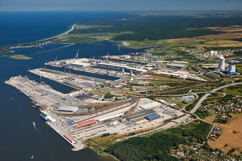
Index
1. Introduction.....................................................................................................3

1.1. Background ...................................................................................................3

1.2. Project objectives ...........................................................................................3

2. Regional preconditions of greening nodes ...................................................................5

2.1. Spatial planning and regulatory framework ...............................................................5

2.1.1. Germany: Berlin-Brandenburg and Mecklenburg-Western Pomerania ...............................5

2.1.2. Italy: Veneto and Emilia-Romagna .......................................................................5

2.1.3. Hungary: Budapest ........................................................................................6

2.1.4. Slovenia: Koper ............................................................................................6

2.2. Transport infrastructure ....................................................................................6

2.2.1. Germany: Berlin-Brandenburg and Mecklenburg-Western Pomerania ...............................6

2.2.2. Italy: Veneto and Emilia-Romagna .......................................................................7

2.2.3. Hungary: Budapest ........................................................................................7

2.2.4. Slovenia: Koper ............................................................................................7

2.3. Renewable energies and energy infrastructure ..........................................................8

2.3.1. Germany: Berlin-Brandenburg and Mecklenburg-Western Pomerania ...............................8

2.3.2. Italy: Veneto and Emilia-Romagna .......................................................................8

2.3.3. Hungary: Budapest ........................................................................................9

2.3.4. Slovenia: Koper ............................................................................................9

2.4. Development concepts and strategies .....................................................................9

2.4.1. Germany: Berlin-Brandenburg and Mecklenburg-Western Pomerania ...............................9

2.4.2. Italy: Veneto and Emilia-Romagna .......................................................................9

2.4.3. Hungary: Budapest ...................................................................................... 10

2.4.4. Slovenia: Koper .......................................................................................... 10

                                                                                                              Page 1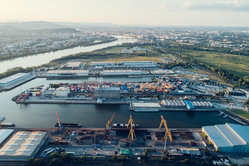
3. Spatial needs of urban nodes................................................................................ 11

3.1. Berlin ........................................................................................................ 11

3.2. Port of the Hanseatic city of Rostock .................................................................... 12

3.3. Port of Venice .............................................................................................. 15

3.4. Bologna Freight Village ................................................................................... 17

3.5. Freeport of Budapest ..................................................................................... 19

3.6. Port of Koper .............................................................................................. 22

4. Conclusion and outlook ...................................................................................... 25

                                                                                                                Page 2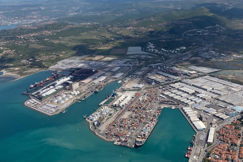
1. Introduction
1.1. Background
Ports are hubs for national and international freight transport and transshipment points for imported energy
sources. In the context of climate change, ports are gaining importance in the energy transition. The
changing energy production is accompanied by structural changes in the port industry. This development
has far-reaching effects on all functional levels of the ports (handling, logistics and industrial function).
On the one hand, the ports are affected as transshipment centers for energy sources. Changes in energy
production are inevitably accompanied by changes in the structure of the types of goods and the range of
services offered by the port industry. On the other hand, in order to achieve the European climate targets,
the port industry and freight transport must also become "greener" themselves. In addition to the generation
and use of renewable energies, increasing energy efficiency and reducing energy consumption are key
aspects for implementing sustainable energy management in ports and freight villages.
Due to the structural change caused by the energy transition and the coal phase-out, the handling of
conventional fossil fuels (primarily coal and oil products) will decline. The challenge for ports i s to
compensate these losses with other business models. Fields of action include e.g. - for some time now -
equipment and supply services for offshore wind farms, including the establishment of corresponding
production sites for offshore wind components, and - in the near future - the construction of LNG terminals.
Port locations will also assume a central function in the hydrogen economy. In addition to green hydrogen
production in electrolysis plants, the establishment of import terminals and the development of
corresponding distribution structures will set new value-added processes in motion, ideally in connection
with the establishment of industrial companies that use hydrogen in their production processes.
In the more distant future, ships with fuel cells and vehicles in port/ freight village operations can be
supplied with green hydrogen through the development of filling station networks. Hinterland traffic can
also be made more ecological with hydrogen-powered trucks or trains. In addition to hydrogen, other
alternative fuels, such as green ammonia, are also suitable in the long term to replace the heavy oils and
marine diesel as well as LNG that are predominantly used in shipping.
Another key aspect is the sustainable development of the energy infrastructure in ports and freight villages
to distribute and store the generated renewable energy. Via integrated port/ freight village networks (smart
grids), green electricity can be supplied to terminals, logistics centers and port companies, as well as to
handling and conveying equipment used in port/ freight village operations and electric vehicles.
Equipping berths with shoreside power systems enables ships to be supplied with renewable electricity,
which minimizes climate-damaging emissions as well as noise and vibrations during berthing times. Inland
shipping and short sea shipping (especially ferry shipping) will increasingly use battery-electric and hydrogen
drives, whose supply could be ensured via smart grids and charging stations with green electricity as well
as via a hydrogen infrastructure.
The installation of smart grids offers the possibility of intelligently managing the energy supply of the ports
and freight villages. In addition, measures to reduce the energy consumption and to increase the energy
efficiency of cargo handling operations can also make a significant contribution to improving the carbon
footprint.

1.2. Project objectives
The Interreg CENTRAL EUROPE project “Intermodal Green Alliance – Fostering Nodes” - InterGreen-Nodes
represents a continuation of the completed projects on transnational cooperation in the Scandria ® spatial
development corridor. The focus of InterGreen-Nodes is on improving the coordination of actors in freight
transport with the aim of establishing multimodal, environmentally friendly freight transport solutions. The
                                                                                                         Page 3
project focuses on the development of green, intermodal last mile freight transport in urban nodes in
Central Europe.
The project activities concentrate on transport hubs (ports, freight villages) in Berlin, Rostock, Venice,
Bologna, Budapest and Koper. Within the framework of InterGreen-Nodes, the spatial requirements and
needs for the implementation of a green last mile in intermodal ports and freight terminals are analysed.
The project partners will then develop regional action plans based on the analysis, laying out specific
activities that will help them transition towards a greener freight transport in their urban node. In addition,
innovative green logistics solutions will be demonstrated and transferred to the entire Central Europe
program region.
WPT2 addresses the spatial issues of nodes. Therefore, the first activity A.T2.1 is dealing with the spatial
planning part of integrating a green last mile. Based on questionnaire campaigns the regional preconditions
of greening nodes in the partner regions in terms of spatial planning, transport infrastructure and utilization
of renewable energies as well as spatial needs and challenges within the nodes were analysed.
The results of the analysis of regional spatial preconditions (D.T2.1.1) and of the spatial needs (D.T2.1.2)
will be outlined in this transnational summary report on spatial/ regional needs implementing green
solutions (D.T2.1.3) and serve as baseline for the development of regional action plans (D.T2.1.4), the main
output (O.T2.1) of activity A.T2.1.

                                                                                                        Page 4
2. Regional preconditions of greening nodes
2.1. Spatial planning and regulatory framework
2.1.1. Germany: Berlin-Brandenburg and Mecklenburg-Western Pomerania
In Germany, the Federal Spatial Planning Act (ROG) regulates the establishment of spatial plans. These are
large-scale plans, which are applicable for federal states or their subspaces (so-called planning regions).
The German Federal Building Code (BauGB) is a federal law and regulates everything associated to planning
and construction in municipalities. Amongst others, it provides regulations for the establishment of land-
use plans and developments plans for selected section of the municipality for construction. The State
Planning Contract between Berlin and Brandenburg is the legal basis for common spatial planning on federal
state level in Berlin-Brandenburg. In Mecklenburg Western-Pomerania, spatial planning on federal state
level based on the State Planning Act M-V (LPlG M-V).
The State Development Plan Berlin-Brandenburg (LEPro, 2007) and the State Spatial Development
Programme M-V (LEP M-V, 2016) represent the overall framework for joint spatial planning of the capital
region Berlin-Brandenburg and for spatial planning of the federal state Mecklenburg-Western Pomerania.
The State Spatial Development Programme M-V (LEP M-V) also includes spatial planning for the coastal sea
area. As a pioneer in Germany and in Europe, maritime spatial planning was already implemented in the
LEP M-V 2005. Both spatial planning instruments contain binding goals and principles for sustainable
settlement, open space and transport development, among others, and are implemented at the regional
level through regional plans/programmes (BB: 5 Regional Spatial Plans for Brandenburg, MV: 4 Regional
Spatial Development Programmes).
The regional plans/ development programmes form the specifications set out in the state spatial
development plan/ programme in factual terms and concretize them in a region-specific way. Important
concretization are e.g. the suitability areas for wind energy plants. These plans/ programmes are the basis
for spatial planning at the municipal level in Germany, which is carried out by land-use plans for each
municipality and developments plans for selected section of municipalities.
2.1.2. Italy: Veneto and Emilia-Romagna
The Italian law includes regulations on land-use planning at the national, regional and municipal levels.
Spatial planning in Italy shows a strong dominance of the local level. The spatial planning system is rooted
in the country's architecture and based on a national law from 1942. The national law no.1150/1942 is the
national urban planning law and regulates the territorial/urban planning in Italy. The Law no. 24/2017,
art.40 specifies that each region in Italy must have a Regional Territorial Plan (Piano Territoriale Regionale
– PTR). The PTR as the regional planning tool defines the objectives for ensuring social cohesion and
development, an increase of competitiveness of the regional territorial system and the reproducibility,
qualification and enhancement of the environmental and social resources (Law no.20/2000, art. 23).
The Regional Territorial Plans (PTR) regulate spatial planning at the regional level in Italy and were created
with the aim of providing an overview of the future of regional society, towards which the planning of the
institutions' decisions is directed, and a framework for the action of public and private actors in the
development of the regional economy and society. The PTR in force in the Emilia-Romagna Region was
approved by the Legislative Assembly with resolution no. 276 of 3 February 2010 pursuant to regional law
no. 20 of 24 March 2000. In the Veneto Region, the Regional Territorial Coordination Plan (PTRC) was
approved by the Regional Council in 2020 (resolution no. 62 of 30 June 2020).
The local development based on the Urban and Sustainable Territorial Development Program (Programmi di
Riqualificazione Urbana e di Sviluppo Sostenibile del Territorio - PRUSST) is established by the Ministry of
Public Works. The programme promotes diversified investments in different sectors, leading to progress in
Page 5improving large-scale transport systems connecting different regions, restoring historic buildings and
renovating or converting industrial sites into mixed-use sites.
2.1.3. Hungary: Budapest
In Hungary, spatial planning is regulated at three levels (national, county and local level), with designated
areas such as the Budapest agglomeration being regulated separately. The Law on Shaping and Protecting
the Built Environment (Act LXXVIII, 1997) is the legal basis for the Hungarian spatial planning. With this Act,
the hierarchy of the various spatial development plans was established. In 2003, the first National Spatial
Plan was created (Act XXXVI, 2003). In 2018, a new National Spatial Plan for Hungary and some of its priority
regions came into force (Act. CXXXIX, 2018).
The Government’s Decree 253/1997 on National Settlement Planning and Construction Requirements (OTÉK)
and the Act XXI/1996 on Regional Development and Regional Planning contain additional regulations for
planning at regional and local level. In 2014, by the Parliament Resolution No. 1/2014. (I. 3.) OGY the
National Development and Territorial Development Concept 2030 was passed.
Regulatory framework conditions for the Budapest agglomeration are the Building Regulation of the Danube
bank (Duna-parti Építési Szabályzat (DÉSZ), the Budapest Capital City Settlement Structure Plan (Budapest
Főváros Településszerkezeti Terv) and the Budapest Capital City Settlement Planning Regulation (Budapest
Főváros rendezési szabályzat). Furthermore, a District Building Regulation and an Integrated Urban
Development Strategy were determined for Budapest. In 2013, the Budapest 2030 Long-Term Urban
Development Concept was adopted.
2.1.4. Slovenia: Koper
In Slovenia, there are regulations on spatial planning at the national, regional and municipal level. The
Spatial Development Strategy of Slovenia (2004) and the Spatial Planning Order of Slovenia (2004) contained
the first goals and guidelines for spatial development. The basic laws regulating the Slovenian spatial
planning are the National Spatial Planning Act (2017) and the National Building Act (2018). Based on these
acts National Spatial Plans and Municipal Spatial Plans were developed.
The National spatial plan for comprehensive spatial arrangement of the international port in Koper was
adopted in 2011 and is the most important regulatory framework for the spatial development of the port of
Koper. Currently, there is also a Maritime Spatial Plan for the Slovenian coastal zone in preparation. This
regional spatial plan will set guidelines for maritime uses. Among other coastal areas, it is considering the
port area of Koper.
2.2. Transport infrastructure
2.2.1. Germany: Berlin-Brandenburg and Mecklenburg-Western Pomerania
The Federal Transport Infrastructure Plan 2030 (BVWP, 2030) is the strategic basis for the maintenance,
development and expansion of the transport infrastructure relevant for the federal government in Germany.
These include federal highways, federal railways and federal waterways. It is also the infrastructural basis
for the introduction of the so-called Deutschlandtakt (timetable) for railways in 2030.
In the region Berlin-Brandenburg, the Berlin Mobility Act (2018) and Brandenburg Regional Public Transport
Plan (LNVP, 2018) are applicable in terms of transport infrastructure development. The focus of the Berlin
Mobility Act is set on passenger transport like public transport, cycling and commuter traffic between Berlin
and Brandenburg - safer, more mobile and climate-friendly.
Page 6The Integrated Transport Plan M-V (ILVP M-V) is the mobility concept in Mecklenburg-Western Pomerania
and deals with all means of transportation (car, train, bus, and bicycle). The plan provides concrete
recommendations for action for the development of mobility in the federal state of Mecklenburg -Western
Pomerania.
2.2.2. Italy: Veneto and Emilia-Romagna
The National Plan for Ports and Logistics is the general regulation for transport infrastructure development
in Italy. At the regional level, this national regulation will be specified and implemented by regional
transport plans, which incorporate strategies and requirements for transport planning on regional, provincial
and municipal level. The regional transport plans are supplemented by provincial territorial coordination
plans.
In the Veneto Region, the Regional Plan for Transport 2020-2030 (Piano Regionale dei Trasporti del Veneto
2020-2030 - PRT) is in force. The focus of this plan is on sustainable transport development. Therefore,
transport, mobility and infrastructure development strategies being elaborated. In addition, the Urban Plan
for Sustainable Transport Mobility – Venice 2030 (Piano urbano della mobilità sostenibile - PUMS PER I
TRASPORTI - VENEZIA 2030) is the long term strategy for a visionary, sustainable urban mobility in Venice.
In the Emilia-Romagna Region, the Regional Law 2nd October 1998, n.30 regulates the regional and local
public transport. Furthermore, the legislative decree no.112/2015 on the development of the rail
infrastructure and legislative decree no.1/2012 – A.C.5025 on the coherence, development and
competitiveness of the infrastructures are applied in this Italian region for transport infra structure
development. The main instrument for regional, provincial and municipal transport planning in Emilia-
Romagna is the Regional Integrated Transport Plan (Piano Regionale Integrato dei Trasporti del Emilia-
Romagna – PRIT), which include planning guidelines and mobility policy directives. Currently, the region
started to work on the PRIT2025 to revise the currently valid PRIT from 1998. Additional regulatory
framework conditions for mobility in the Emilia Romagna Region are integrated in the Basin Plan on Local
Public Transport (Piano di bacino del trasporto pubblico locale, PdB).
2.2.3. Hungary: Budapest
At national level, the National Transport Infrastructure Development Strategy regulates the transport
infrastructure development in Hungary and consist of short-term (2020) and long-term (2030) strategies as
well as of a visionary perspective for 2050. Additionally, the National Spatial Plan (Act. CXXXIX, 2018) defines
the international alignment of transportation networks for the next decades.
The main transport concept for Budapest in the period from 2020 to 2030 is the Budapest Mobility Plan.
With this plan, a framework for a strategic urban mobility planning was established to develop the city
transport system sustainably in the next decade.
2.2.4. Slovenia: Koper
In the Republic of Slovenia, the Transport Development Strategy until 2030 is the long-term strategy for
transport planning and transport infrastructure management. The National Roads Act, the National Road
Transport Act and the National Railway Transport Act are the basic laws applicable in terms of the Slovenian
transport infrastructure development. These regulations will be supplemented by the Maritime Code for the
coastal zone of Slovenia.
Page 72.3. Renewable energies and energy infrastructure
2.3.1. Germany: Berlin-Brandenburg and Mecklenburg-Western Pomerania
The Climate Action Programme sets Germany's climate mitigation targets for 2030. This includes a
comprehensive catalogue of measures and incentives to cut CO 2 emissions and to foster technological
solutions. The CO2 pricing, refurbishing buildings, energy pricing as well as electric mobility and charging
infrastructure are further components of the Climate Action Programme. With the Climate Action Plan 2050,
the German government implemented the Paris Climate Agreement in 2016 through a long-term climate
mitigation strategy and further specified the national climate mitigation targets. In addition, The National
Hydrogen Strategy and the Master Plan for Charging Infrastructure of the federal government support the
utilisation of renewable energies and alternative fuels in the transport sector in Germany.
The Renewable Energy Act Germany (EEG, 2021) is the basis for the expansion of renewable energies and of
energy corridors as well as the net expansion. The law regulates the input of electricity from renewable
sources into the power grid and guarantees their producers fixed feed-in tariffs with the goal to increase
the use of renewable energy up to 65% by 2030. Furthermore, National Energy Efficiency Strategy 2050
contributes significantly to the energy transition and to the achievement of European energy and climate
policy goals. By 2030, the total primary energy consumption of Germany is to be reduced by 30 % (compared
to 2008).
The Energy Strategy 2030 Brandenburg aims to reduce energy consumption by 23 % and to increase the use
of renewable energy up to 40% by 2030. The strategy contains a catalogue of measures for grid extension,
bridging technology and storage technology, etc. In Berlin, the Berlin Energy and Climate Protection
Programme 2030 includes a set of strategies and measures to make the city carbon-neutral by 2050. It will
be implemented from 2021.
With the State Energy Concept M-V, Mecklenburg-Western Pomerania wants to advance the energy
transition, especially in the task areas of citizen participation, energy and climate policy. To this end,
comprehensive measures and targets have been formulated for these task areas up to 2025. In addition, the
Climate Action Plan M-V was developed to reduce greenhouse gas (GHG) emissions and contains concrete
climate actions in the areas of, among others, energy saving, energy efficiency and renewable energies, as
well as in the action fields agriculture and forestry, tourism, construction and transport. The Climate Action
Plan M-V is currently being revised to meet the climate goals in the next decade.
2.3.2. Italy: Veneto and Emilia-Romagna
Besides the National Transport and Logistics Strategic Plan, the national regulation for alternative fuels
infrastructure, adopting the EU Directive 2014/94 (DLGS 2016/257), and the National Infrastructure Plan for
Charging of Electric Vehicles (PNIRE, 2016) are the legal framework for the renewable energy utilization
and energy infrastructure development in Italy.
In the region Emilia-Romagna, the regional law n.26 of the 23rd December 2004 is the basis for energy
planning. The Regional Energy Plan (Piano Energetico Regionale – PER) include the strategy and targets for
climate mitigation of the Emilia-Romagna Region until 2030. It deals with requirements in terms of
renewable energy, energy efficiency and green economy as well as with innovation, research and
communication aspects. The Integrated Regional Plan on Air (Piano Aria Integrato Regionale – PAIR) contain
further regulatory framework conditions for climate mitigation in this Italian region.
The region of Veneto has no Regional Energy Plan.
Page 82.3.3. Hungary: Budapest
Hungary´s National Energy Strategy (2012) focuses on energy efficiency and energy savings as well as on
renewable energies and the security of energy supply. It sets targets and measures for sustainable energy
systems until 2030 and give an outlook until 2050. The National Energy Strategy also requires the
development of sustainable transport concepts.
The Second National Climate Change Strategy (NCCS-2, 2018) determines climate mitigation targets until
2030 and strategic guidelines for short-, mid- and long-term actions. The goal is to cut the Hungarian GHG
emissions by 40 % until 2030 in relation to their level in 1990.
The National Renewable Energy Action Plan 2010-2020 outlines how Hungary wants to meet the EU 2020
climate mitigation targets (EU Directive 2009/28/EC), in particular the share of renewable energy of the
Hungarian total energy consumption.
2.3.4. Slovenia: Koper
In Slovenia, the legal basis for renewable energy utilisation and energy infrastructure development is the
National Energy Act. Currently, a National Sustainable Mobility Act is being in preparation by the Ministry of
Infrastructure.
With the National Energy and Climate Plan (2020) the Slovenian government sets energy and climate
mitigation targets for 2030 and gives a perspective for 2040. Furthermore, the National Renewable Energy
Action Plan (2010) and the National Action Plan for Energy Efficiency supplement the national instruments
in terms of renewable energy, energy consumption and management in Slovenia. The resolution on a
National Energy Concept is to be adopted by the Slovenian Government.
In addition, the National spatial plan for comprehensive spatial arrangement of the international port in
Koper is also the basis for energy infrastructure planning.
2.4. Development concepts and strategies
2.4.1. Germany: Berlin-Brandenburg and Mecklenburg-Western Pomerania
Supportive strategies for greening nodes in the joint planning region Berlin-Brandenburg are the Urban
Development Plan Transport Berlin and the Mobility Strategy 2030 Brandenburg. The Urban Development
Plan Transport forms the framework for the concrete planning and measures in the Berlin transport sector
and the Mobility Strategy 2030 serves as guideline for the mobility policy until 2030 for all modes incl.
challenges like climate, environment, demographic change and innovation in Brandenburg.
The State Ports Development Concept Mecklenburg-Western Pomerania 2030 supports the sustainable land
development of port locations in Rostock, Sassnitz/Mukran, Stralsund, Vierow and Wismar. It identifies
spatial needs until 2030 and development priorities, and derives employment effects of land use planning.
The National Hydrogen Strategy of the German Government and the Hydrogen strategy of Northern Germany
represent supportive strategies for greening nodes. Northern Germany is to be transformed into a hydrogen
region with all of its value chains. In this context, the ports are to play a special role in the import and the
production of hydrogen.
2.4.2. Italy: Veneto and Emilia-Romagna
The main approach for the sustainable development of the nodes in the Veneto Region is linking the Venetian
ports to inland ports and complying with the TEN-T corridors. The Port Development Plan (Pot) is the central
Page 9instrument for the further development of the port of Venice. Furthermore in the Regional Transport Plan
of the Veneto Region strategies for moving freight from trucks to rail are anchored.
In Emilia-Romagna, the private association Clust-ER Innovate, the IT platform Cluster Community System
(CluCS) and intermodal cluster ER.I.C. support the regional transport development. A supportive strategy
for greening nodes in the Emilia-Romagna Region is the Sustainable Urban Mobility Plan (Piano Urbano della
Mobilità Sostenibile - PUMS) of the Metropolitan City of Bologna. It defines the priority strategies to meet
the mobility demand of citizens and businesses in urban and peri-urban areas, with the main goals:
accessibility, climate protection, air healthiness, road safety, liveability and transferability.
2.4.3. Hungary: Budapest
In Hungary there is no regional development concept for all nodes in the region as there is no regional-level
planning. Therefore, there is no regional development concept in the Budapest-Central Hungarian region.
Nevertheless, the National Port Development Strategy goals are clear in greening the ports and the freight
traffic in Hungary. The strategy sets out directions for the development of the Danube ports infrastructure
and port services and the entire sector by 2030.
The Freeport of Budapest has a masterplan to develop its port area, as there is still a substantial reserved
area that can be used for the extension of the port.
The Budapest Mobility Plan 2030 (SUMP of Budapest) as the transport strategy for Budapest for the 2020-
2030 period supports the sustainable, green development of the local transport systems and contribute to
a liveable and environmentally friendly urban environment. The Plan also defines the most important
transport development projects until 2030, defining three main scenarios depending upon the available
budget.
2.4.4. Slovenia: Koper
Supporting strategies for greening nodes in Slovenia are the National Energy and Climate Plan and the
resolution on the National Energy Concept as well as the National Renewable Energy Action Plan and the
National Action Plan for Energy Efficiency.
The management board of Luka Koper (port of Koper) adopted a Strategic Business Plan for the period 2020-
2025, the main development concept for the port. Energy efficiency and sustainability is an important part
of the document, where solar power plants are included.
Page 103. Spatial needs of urban nodes
3.1. Berlin
Port´s character Universal industrial port
Total cargo throughput 4,000,000 t p.a.
Main cargoes Container, fuels, bulk cargo, break bulk and heavy
cargo
Total port area 40 ha
TENT-T Core Network Corridors North Sea – Baltic
Orient - East-Mediterranean
Scandinavian - Mediterranean
Infrastructure/ transport links Road, water, rail
Economic sectors/ Logistics and property management
established branches of industry
Port-related jobs 500
Production and utilization Solar power plants on the roof of storage
of renewable energy warehouses
Utilization of alternative fuels Electricity, in future hydrogen and CNG
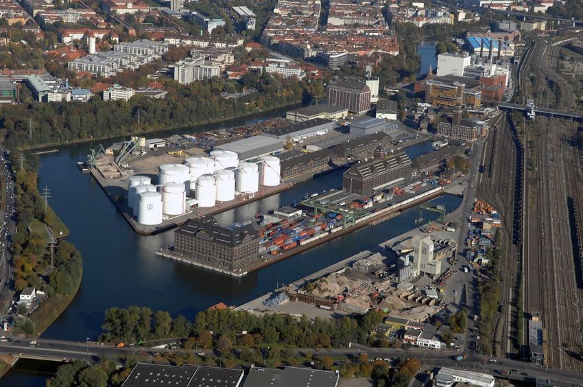
Aerial photo Westhafen Berlin (Source: www.euroluftbild.de)
Page 11DEVELOPMENT CONCEPT/ STRATEGY
Development of locations Westhafen, Südhafen Spandau, Hafen Neukölln for port logistics related activities.
Südhafen Spandau: modernization of existing infrastructure in Unterhafen, development of new port
infrastructure in Oberhafen
Hafen Neukölln: relocation of lock Schleuse Neukölln towards direction north so as to allow for 85m
barges to enter the Unterhafen basin; filling of Oberhafen basin to create area for warehouses and
infrastructure
Westhafen: modernization and optimization of infrastructure and superstructure; optimization of
utilization port area.
DEVELOPMENT FOCUS (area, infrastructure, industrial and commercial settlements)
Infrastructure and the best use out of the existing areas
SUSTAINABILITY AS PART OF THE DEVELOPMENT STRATEGY/ CONCEPT (main goals: e.g. GHG reduction,
use of alternative fuels and supply of renewable energy)
Use of alternative fuels
Supply of renewable energy
Forerunner in development and use of climate friendly and sustainable use of energy and material
FORECAST CARGO THROUGHPUT DEVELOPMENT UNTIL 2030 (total throughput per cargo type)
6,000,000 tons p.a. estimate
SPATIAL NEEDS UNTIL 2030 (e.g. extension areas for port transhipment/ freight handling, demand for
berths; settlement areas for port-related industry and logistics companies, extension areas for railway and
road networks; deepening of shipping channels)
All above mentioned port locations have no opportunity for spatial growth as they are all enclosed by other
properties. Spatial needs for port premises derive from demand in the city to provide means of transport
for large amounts of cargo. Ports enable environmentally friendly ship and rail transport to inner city and
help prevent road congestion by reducing road traffic.
MAIN LAND USE CONFLICTS (e.g. settlement development, fishery, military uses, landscape conservation,
species protection, agriculture and forestry, tourism)
Interest groups that favour housing development before port development are currently causing the main
problems. In general – all of the above are hindrances towards port development (or logistics site
developments in general).
3.2. Port of the Hanseatic city of Rostock
Port´s character Universal port, with strong focus on ferry and ro/ro
Page 12Total cargo throughput 2017: 26.9m tons
2018: 25.6m tons
2019: 25.7m tons
Main cargoes Approx. 60 % ferry and ro/ro cargo
Approx. 30 % bulk
Approx. 10% liquid
Approx. 2 % general cargo
Total port area Total port area around 750 ha
TENT-T Core Network Corridors Orient – East-Mediterranean
Scandinavian - Mediterranean
Infrastructure/ transport links Direct motorway access to A19 (N-S) and A20 (E-W);
rail shunting yard directly south of the port and
nearly all piers equipped with rail
Economic sectors/ Port as industrial production cluster in the region
established branches of industry with strong focus on steel products (Liebherr
cranes, offshore pipes); additionally agriculture
industry with a port affine production volume
Port-related jobs Direct port related jobs approx. 10,800 and approx.
6,000 indirect port related jobs (2019)
Production and utilization Wind turbine components, on- and offshore power
of renewable energy components in and close to the port
Utilization of alternative fuels LNG bunkering for vessels possible in the port,
public re-charging stations for e-cars under
development,
In the near future a small scale LNG import terminal
is available with bunker opportunities even for
trucks and other land-based transport modes,
Options for other alternative fuels are currently
under evaluation
DEVELOPMENT CONCEPT/ STRATEGY
Port Development Plan 2030 (HEP 2030)
https://firebasestorage.googleapis.com/v0/b/dialogue-rostock-
dev.appspot.com/o/rostockMediathekMaterialien%2FHEP2030.pdf?alt=media&token=5e526bf4 -
2524-49f3-8f4c-38ec75bd6f5a
DEVELOPMENT FOCUS (area, infrastructure, industrial and commercial settlements)
General focus is on ensuring port area expansion for industrial settlements and port handling activities as
well as implementation of green solutions when feasible and economically viable.
SUSTAINABILITY AS PART OF THE DEVELOPMENT STRATEGY/ CONCEPT (main goals: e.g. GHG reduction,
use of alternative fuels and supply of renewable energy)
Port handling and provision of alternative fuels/ energies
Supply of renewable energy for existing and new industrial settlements and port handling companies
Page 13Aerial photo port of the Hanseatic city of Rostock (Source: ROSTOCK PORT/ Nordlicht)
FORECAST CARGO THROUGHPUT DEVELOPMENT UNTIL 2030 (total throughput per cargo type)
Semi-finished and finished goods, textiles: 14.3m tons
Grain, feed: 4.8m tons
Crude Oil: 3.1m tons
Petroleum products: 2.1m tons
Chemical products: 1.5m tons
Building materials: 1.4m tons
Fertilizer: 1m tons
Wood: 0.9m tons
Paper, paper products: 0.6m tons
Iron ore, iron, steel: 0.8m tons
SPATIAL NEEDS UNTIL 2030 (e.g. extension areas for port transhipment/ freight handling, demand for
berths; settlement areas for port-related industry and logistics companies, extension areas for railway and
road networks; deepening of shipping channels)
In total, there is a spatial need of 590 ha.
MAIN LAND USE CONFLICTS (e.g. settlement development, fishery, military uses, landscape conservation,
species protection, agriculture and forestry, tourism)
The main conflict will be expected in:
landscape conservation,
species protection and
settlement development.
Page 143.3. Port of Venice
Port´s character Universal port
Total cargo throughput 2017: 25m tons
2018: 26.5m tons
2019: 25m tons
Main cargoes Containers, liquid bulk, break bulk, project cargo,
trailers, general cargo
Total port area 2000 ha
TENT-T Core Network Corridors Baltic – Adriatic
Mediterranean
Infrastructure/ transport links Road, rail, river, airport
Economic sectors/ Steel Industry, animal feeding industry, oversize
established branches of industry products
Port-related jobs 20k employees
Production and utilization Biomass for factories
of renewable energy
Utilization of alternative fuels Project “POSEIDON MED II - Implementing LNG
Marine Bunkering in SE Europe through
Simultaneous Development of Critical Supply
and Demand Side installations”: In the Port of
Venice, Rimorchiatori Riuniti Panfido builds the
first highly innovative prototype of a bunkering
vessel for the transport and bunkering of LNG to
ships, in order to complete the LNG supply chain
in Venice and the North-Adriatic area. The co-
financing concerns the design and construction
of this ship prototype called SBBT (Semi
Ballastable Barge Transporter). This bunker
barge will be the first vessel of this type to be
employed in the whole Mediterranean.
New LNG bunker project „Venice LNG facility“:
construction of a LNG multimodal facility in the
core port of Venice with storage capacity at
32,000 m³, located on the Baltic-Adriatic and
Mediterranean Core Network Corridors. The
action aims at accelerating the deployment of
the alternative fuels network in the Northeast
of Italy. The new LNG port storage facility in
Venice aims to supply the road, maritime and
inland waterways transport modes.
Page 15DEVELOPMENT CONCEPT/ STRATEGY
Infrastructural transformation of former industrial areas to logistics, improving accessibility, evaluating new
berths outside the lagoon and attraction of logistics productive companies:
Port Development Plan (Piano Regolatore Portuale)
https://www.port.venice.it/it/pianificazione-strategica.html
Triennial Port Operative Plan 2018-2020 (Piano Operativo Triennale 2018-2020)
https://www.port.venice.it/it/pianificazione-strategica.html
National Plan for Ports and Logistics
http://www.mit.gov.it/node/5278
Regional Plan for Transport in the Veneto Region 2020-2030 (Piano Regionale dei Trasporti del
Veneto 2020-2030)
https://www.regione.veneto.it/web/mobilita-e-trasporti/piano-regionale-trasporti
Urban Plan for Sustainable Transport Mobility - Venice 2030 (Piano urbano della mobilità sostenibile
- PUMS PER I TRASPORTI - VENEZIA 2030)
https://www.comune.venezia.it/pums
DEVELOPMENT FOCUS (area, infrastructure, industrial and commercial settlements)
Infrastructuring of former industrial areas to logistics and port authorities
SUSTAINABILITY AS PART OF THE DEVELOPMENT STRATEGY/ CONCEPT (main goals: e.g. GHG reduction,
use of alternative fuels and supply of renewable energy)
Reclamation of large port areas once dedicated to heavy and polluted activities
FORECAST CARGO THROUGHPUT DEVELOPMENT UNTIL 2030 (total throughput per cargo type)
In 2030, the port of Venice should reach 26 million tons handled, while the port of Chioggia will be around
one million ton intermediated.
For the port of Venice the result will be determined by the following circumstances:
1) Solid bulk and goods in necks: the tonnage handled will be equivalent to today's value but will be achieved
because of the following structural changes:
almost total disappearance of coal,
increase in the steel and agro-food sectors,
growth of miscellaneous goods and other bulk goods as well as project cargo.
2) Ro-Ro: increase in traffic (+0.9m tons) related to the construction of the second dock in Fusina and other
potential operators that could settle in the port
3) Container: growth due to a satisfied market trend related to the future availability of the new
Montesyndial terminal in the port (+1.2m tons)
4) Liquid Bulk: decrease in handling of approx. 1.1 million tons due to:
changes in the chemical and oil industrial processes of the industries located in the port,
decrease in fuel consumption related to greater efficiency of vehicles and systems and for switching
to electricity and
use of new LNG fuels.
No official forecast for 2030 is available. Currently, maximum capacity is not used.
Page 16SPATIAL NEEDS UNTIL 2030 (e.g. extension areas for port transhipment/ freight handling, demand for
berths; settlement areas for port-related industry and logistics companies, extension areas for railway and
road networks; deepening of shipping channels)
Infrastructuring of large areas for transhipment, logistics and containers: 100 ha
MAIN LAND USE CONFLICTS (e.g. settlement development, fishery, military uses, landscape conservation,
species protection, agriculture and forestry, tourism)
Urban integration
Marine accessibility
Dredging
Tourism
3.4. Bologna Freight Village
Port´s/ freight village´s character Freight village
Total cargo throughput Total cargo throughput (rail & road)
2019: 14,882,146 tons
2018: 13,934,291 tons
2017: 13,221,148 tons
Main cargoes 2019: Container traffic: 495,983 tons
Traditional traffic: 351,932 tons
Combined traffic: 644,683 tons
2018: Container traffic: 492,989 tons
Traditional traffic: 349,726 tons
Combined traffic: 353,576 tons
2017: Container traffic: 450,376 tons
Traditional traffic: 404,728 tons
Combined traffic: 281,892 tons
Total freight village area 411 ha
TENT-T Core Network Corridors Baltic – Adriatic
Scandinavian - Mediterranean
Infrastructure/ transport links A13 motorway (Bologna – Padua), A1 motorway
(Milano - Bologna – Naples), A14 motorway (Bologna
– Taranto),
Direct rail connection with the line Bologna – Padua
– Venezia with connections to Bari (Adriatic line)
and Marcianise – Nola – Catania (Tyrrhenian line)
Economic sectors/ Fashion, food, automotive (spare parts),
established branches of industry pharmaceutical
Logistics real estate, facility and property
Freight village related jobs
management, intermodal transport and railway
activities (handling, shunting and maintenance)
Page 17Production and utilization Solar power plants (about 9,750 kWp of installed
of renewable energy power)
Utilization of alternative fuels The work for the expansion of the current fuel
station adding LNG and CNG pumps will start by
2020. The new station will be operating in the
second half of 2021.
DEVELOPMENT CONCEPT/ STRATEGY
n.a.
DEVELOPMENT FOCUS (area, infrastructure, industrial and commercial settlements)
The Interporto Bologna has two main areas of development:
Logistics real estate development: In the upcoming years, the settlement of a logistics park on area
with more than 4 million sqm, own by Interporto Bologna is planned. On a long-term perspective,
new expansion areas for warehousing, logistics and e-commerce are in consideration.
Railway infrastructure development: The company, together with RFI (Italian railway infrastructure
manager), has the plan to renew and improve the existing facilities (intermodal terminals) in the
next 5-10 years to meet the current EU standards (track length of 750 m, digitalisation and
automation of terminal operations, etc.).
SUSTAINABILITY AS PART OF THE DEVELOPMENT STRATEGY/ CONCEPT (main goals: e.g. GHG reduction,
use of alternative fuels and supply of renewable energy)
One of the main objectives is to improve the environmental efficiency of the logistics hub, by introducing
more sustainable solutions for the freight transport, such as: LNG station, electric charging stations,
intelligent waste management and energy management initiatives. The logistics park is already equipped
with a solar and photovoltaic power plant producing about 9,750 kWp of installed power per year.
FORECAST CARGO THROUGHPUT DEVELOPMENT UNTIL 2030 (total throughput per cargo type)
The company objective in terms of total transported cargo throughput by 2030 is around 20 million tons.
The goal regarding rail transport is to reach 15 % of the total cargo throughput, which means about 3 million
tonnes.
2030 objectives for rail/intermodal traffic:
Container traffic: 1,000,000 tons
Traditional traffic: 800,000 tons
Combined traffic: 1,200,000 tons
SPATIAL NEEDS UNTIL 2030 (e.g. extension areas for port transhipment/ freight handling, demand for
berths; settlement areas for port-related industry and logistics companies, extension areas for railway and
road networks; deepening of shipping channels)
With a view to the year 2030, an additional area of 200 ha can be considered for expansion.
Page 18MAIN LAND USE CONFLICTS (e.g. settlement development, fishery, military uses, landscape conservation,
species protection, agriculture and forestry, tourism)
The main land use conflicts are related to the regional policy of land consumption in relation to agriculture
and landscape conservation.
3.5. Freeport of Budapest
Port´s character Universal port
Total cargo throughput 2017:
1.109m tons on the waterside (1,196 barges)
19,752 rail wagons (out of which 14,786 are
container wagons)
34,8261 trucks
219,299 TEU containers (131,513 pieces, total
weight of 1.401m tons)
2018:
0.916m tons on the waterside (1,017 barges)
28,725 rail wagons (out of which 22,025 are
container wagons)
445,105 trucks
335,923 TEU containers (201,300 pieces, total
weight of 3.222m tons)
2019:
1.168m tons on the waterside (1,301 barges)
29,355 rail wagons (out of which 24,744 are
container wagons)
416,046 trucks
393,773 TEU containers (234,887 pieces, total
weight of 2.977m tons)
Main cargoes Containers, grain and agricultural products, bulk
products, liquid products
Total port area 153 ha (incl. 30 ha of development area which is
currently empty)
TENT-T Core Network Corridors Mediterranean
Orient – East-Mediterranean
Rhine - Danube
Infrastructure/ transport links Railway: “Kelebia” main railway line – Soroksári
shunting railway station is 1,5 kms away.
Waterway: direct access to the Danube via a short
shipping channel.
Road – M0 motorway (ringroad around Budapest):
7kms.
Page 19Economic sectors/ Approx. 70 companies are present in the port:
established branches of industry
Main companies are a wide range and all kind
of logistical companies
There are several smaller logistical services
providers and forwarders operational in the
port area.
Port-related jobs Approx. 1,750
Production and utilization There are sun collectors (to produce hot water)
of renewable energy installed on the roof of 2 warehouses.
There is a new warehouse with a 50 kw solar power
plant on the roof under construction (ready by June
2021).
The installation of a larger solar power plant is very
complicated due to national regulations.
Wind turbines cannot be installed due to
municipality regulations.
Utilization of alternative fuels The CEF funded trimodal LNG terminal is under
construction. First phase will be a capacity of 100
m3. In a later stage, a total capacity up to 1,200 m3
will be extended. Implementation will be
completed by the end of 2021.
Aerial photo Freeport of Budapest (Sourc e: Freeport of Budapest)
Page 20DEVELOPMENT CONCEPT/ STRATEGY
Investment plan of the development area of the Freeport of Budapest
Concept of the road and infrastructure network development of the Freeport of Budapest
Budapest 2030 Long-Term Urban Development Concept
https://budapest.hu/Documents/varosfejlesztesi_koncepcio_bp2030/Budapest_2030_varosfejleszt
esi_koncepcio.pdf
Budapest Mobility Plan 2030
https://budapest.hu/Lapok/2019/budapesti-mobilitasi-terv-2030.aspx
Masterplan Freeport of Budapest
DEVELOPMENT FOCUS (area, infrastructure, industrial and commercial settlements)
Modernisation of existing infrastructure: internal road, rail network and infrastructure in general.
Expansion of the used land: The port has a 30 ha development area, which can be fully used to build
new warehouses and office buildings. This area is undeveloped so the construction of the
infrastructure is necessary, too.
Improving connectivity: The rail connection has a bottleneck (a railway bridge called “Galvani”)
between the shunting station and the port area. This bridge shall be completely modernized.
SUSTAINABILITY AS PART OF THE DEVELOPMENT STRATEGY/ CONCEPT (main goals: e.g. GHG reduction,
use of alternative fuels and supply of renewable energy)
LNG terminal is under installation – see above.
The port will continue the installation of sun collectors and solar panels (up to 50Kws individually) on the
roof of the new buildings.
In the framework of ENERGY BARGE project the installation of a biomass power station (in a cooperation
with the District Heating Company of Budapest) was surveyed – project is currently pending.
The port has also started discussions with the Municipality of Budapest and other stakeholders to develop
an e-cargo mobility service serving the inner city of Budapest. The project success depends heavily on the
regulatory framework, the development of the technology, finding the operator and the existence of a
viable business model. The port cannot operate the fleet itself – can provide land and infrastructure to
maintain, park and charge the fleet.
E-chargers (for cars) will be installed at several points in the port area – it is under planning.
FORECAST CARGO THROUGHPUT DEVELOPMENT UNTIL 2030 (total throughput per cargo type)
1-1.5m tons on the waterside (mostly bulk and liquid products and a smaller percentage of
containers)
A continuous increase of the container terminal between 3-5 % per year
30,000 wagons per year – this is the maximum capacity, which has been achieved by the port. So it
cannot be extended further.
Page 21SPATIAL NEEDS UNTIL 2030 (e.g. extension areas for port transhipment/ freight handling, demand for
berths; settlement areas for port-related industry and logistics companies, extension areas for railway and
road networks; deepening of shipping channels)
30 ha empty area is available in the port which will be developed and warehouses/offices will be built. It
will require an infrastructure development of the area (including road). Internal railway line will not be
extended but rather modernized. Shipping channels and berths are in a good condition. So no further
investment are needed.
MAIN LAND USE CONFLICTS (e.g. settlement development, fishery, military uses, landscape conservation,
species protection, agriculture and forestry, tourism)
Natura 2000 network area is alongside the main Danube (which also belongs to the port) but not
alongside the inner bays. Therefore, it has a minimal effect on the development and operation.
Increasing passenger car traffic is getting a major problem: Access roads around the port are
sometimes blocked during peak hours. So the accessibility of the port can be difficult.
There are limits imposed on the heights of the buildings due to the landscape conservation. Also
installation of green roof is a must on the new buildings due to the same regulations.
In general, the conflict between nature conservation and the regulatory needs of the waterway
(Danube) leads to a stalemate, so that the water level fluctuates strongly, which has a negative
impact on the use of the port.
3.6. Port of Koper
Port´s character Universal port
Total cargo throughput 2017: 23.37m tons
2018: 24.05m tons
2019: 22.79m tons
Main cargoes Containers, ro-ro, general cargo, break bulk, liquid
cargo
Total port area 280 ha
TENT-T Core Network Corridors Baltic – Adriatic
Mediterranean
Infrastructure/ transport links Rail (railway tracks: 38 km), road, berths (28)
Economic sectors/ Logistics
established branches of industry
Port-related jobs Freight forwarders, shipping agents, truck drivers,
rail operatives, harbour master, etc.
Production and utilization Solar power plants (in InterGreen-Nodes project)
of renewable energy Use of waste material as a heating source
Page 22Utilization of alternative fuels Currently, none of these is in use.
The following uses are planned:
LNG for servicing vessels,
electricity for on-shore power supply,
wind and solar power as well as
electricity for ground machinery.
Aerial photo port of Koper (Sourc e: Luka Koper d.d.)
DEVELOPMENT CONCEPT/ STRATEGY
National spatial plan for comprehensive spatial arrangement of the international port in Koper
http://www.pisrs.si/Pis.web/pregledPredpisa?id=URED5830
Strategic business plan 2020 – 2025
https://www.luka-kp.si/eng/mission-vision-strategy
DEVELOPMENT FOCUS (area, infrastructure, industrial and commercial settlements)
Increasing port’s capacities by building new berths and even terminals (focus on containers and cars
as a strategic cargo groups), establishing partnerships with various partners, and setting up new
railway connections with the hinterland markets
Digital transformation
Increase in throughput volumes, thereby maintaining primacy among the ports in the northern
Adriatic and the Mediterranean
Page 23SUSTAINABILITY AS PART OF THE DEVELOPMENT STRATEGY/ CONCEPT (main goals: e.g. GHG reduction,
use of alternative fuels and supply of renewable energy)
The port shall achieve the highest standards of sustainable development under the EU's ECO Management
and Audit Scheme (EMAS) and reduce the company's carbon footprint through energy-efficient improvement
measures. The port´s operator will acquire and actively upgrade the ISO 50001 – Energy Management System
certificate. The needs of the hinterland countries and the possibility of handling all types of alternative
fuels will be analysed. In addition, by 2025, the possibilities of providing alternative sources of energy for
ships will be explored and the port will continue with activities aimed at providing onshore power charging
for ships. Over the coming years, the port´s operator will accelerate its investments made in the use of
renewable energy sources in order to increase energy s elf-sufficiency. It is planned to build several
photovoltaic power plants that will be the primary renewable energy source in the port and will contribute
to reducing the carbon footprint of the company. Due to the importance of electric mobility, so we are
accelerating the construction of a charging infrastructure for electric passenger vehicles will be accelerated
and the gradual electrification of the machinery used in the port will be implemented (Source: Luka Koper
Strategic business plan 2020-2025).
FORECAST CARGO THROUGHPUT DEVELOPMENT UNTIL 2030 (total throughput per cargo type)
The total annual throughput will exceed 35 million tons in 2030, on the assumption that the cargo structure
will remain the same.
SPATIAL NEEDS UNTIL 2030 (e.g. extension areas for port transhipment/ freight handling, demand for
berths; settlement areas for port-related industry and logistics companies, extension areas for railway and
road networks; deepening of shipping channels)
In the period from 2020 to 2030, the port area is expected to grow by 42 ha to 330 ha. The additional spatial
demand is composed in particular of additional areas for railway tracks, berths, warehouses and facilities
for rolled sheets as well as for parking.
MAIN LAND USE CONFLICTS (e.g. settlement development, fishery, military uses, landscape conservation,
species protection, agriculture and forestry, tourism)
Maritime spatial plan (considering different types of land use) is in preparation.
Legislation and technology for relocation of dredged material at the sea bottom (not yet developed).
Development of the port towards the Municipality of Ankaran area (to the north)
Establishment of the AOK (“Ankaranski obrobni kanal”) – habitats replacement for the use of landfills
(for disposal of dredged material; for storage areas for cars)
Page 24You can also read