KILDARE COUNTY DEVELOPMENT PLAN - 2017-2023 Variation (No. 1) of the - Planning Department Kildare County Council 9th June 2020
←
→
Page content transcription
If your browser does not render page correctly, please read the page content below
Variation (No. 1) of the

              KILDARE COUNTY
              DEVELOPMENT
              PLAN
              2017–2023

Planning Department
Kildare County Council
9th June 2020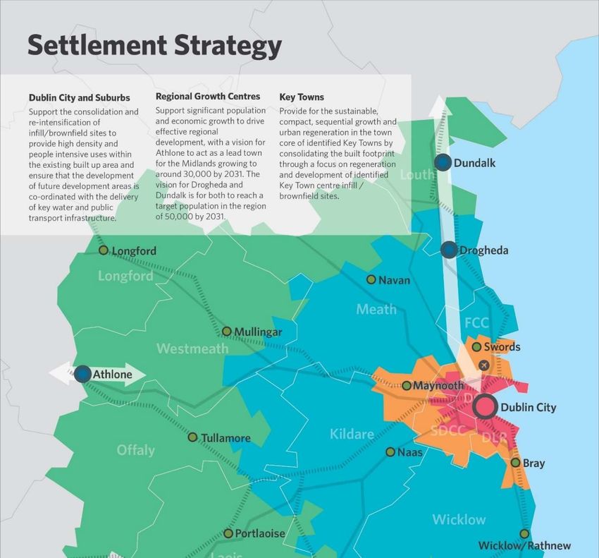
Kildare County Council resolved to adopt Variation No. 1 of the Kildare County Council
Development Plan 2017-2023 at its adjourned special meeting on the 9th June 2020.

Variation No. 1 of the Kildare County Council Development Plan 2017-2023 is effective
as of the 9th June 2020.

This document outlines amendments to the Written Statement to the Kildare County
Development Plan 2017-2023 and should be read in conjunction with same.

                                                                                         1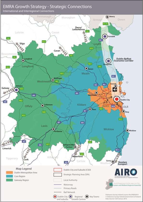
Chapter 1
Amendment No. 1
Chapter Section Page(s)
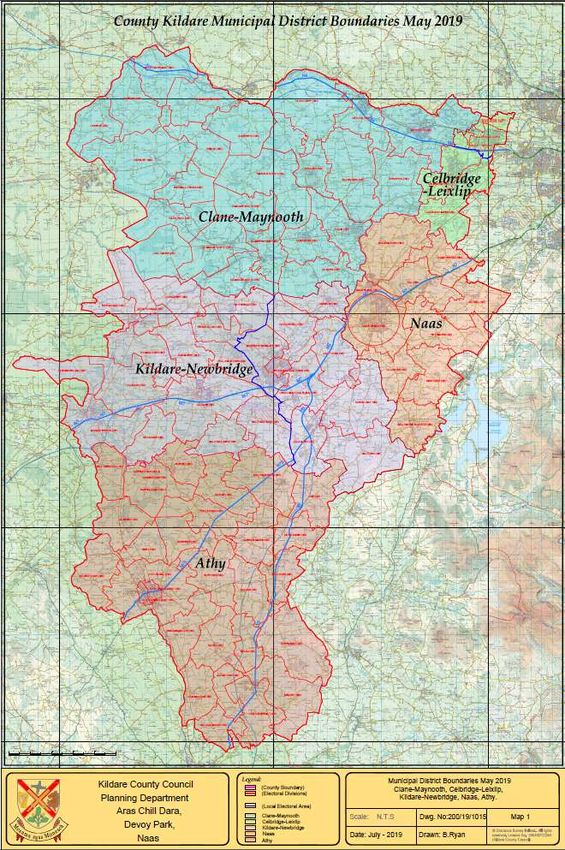
Chapter 1: Introduction & Strategic Context Map 1.1 under Section 1.1 17
Amendment
Replace Map 1.1 with new map to illustrate revised Municipal District
Boundaries.
Map 1.1 Municipal District Areas in County Kildare
2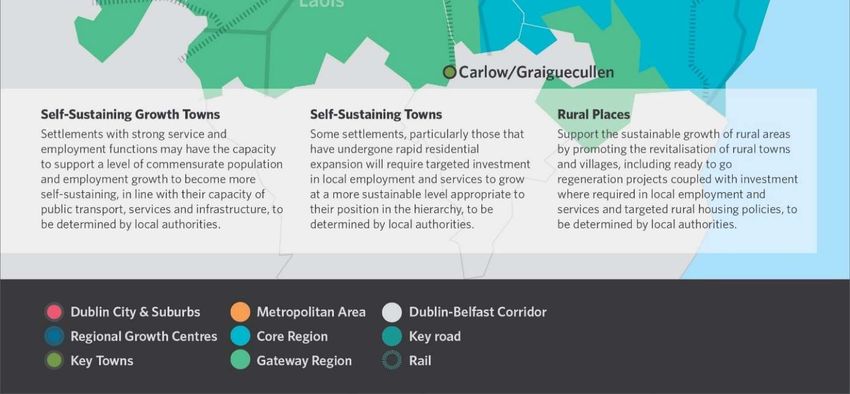
Amendment No. 2
Chapter Section Page(s)
Chapter 1: Introduction & Strategic Context Section 1.4.1(i) 21
Amendment:
Delete Section 1.4.1(i) National Spatial Strategy for Ireland (NSS) 2002-2020 in
its entirety and replace with text in relation to the National Planning Framework.
Insert a new Section 1.4.1(i)(a) in relation to the Implementation Roadmap for
the National Planning Framework.
Insert a new Section 1.4.1(i)(b) Office of the Planning Regulator (OPR) to
reference the role of the OPR
1.4.1 National Policies and Strategies
The following paragraphs set out a brief summary of the main provisions of national
plans, policies and strategies, which relate to the proper planning and sustainable
development of the area covered by this Plan.
(i) Project Ireland 2040: National Planning Framework
The National Planning Framework (NPF) is a Government plan for action and delivery
between now and 2040. The document was adopted in February 2018 and replaces the
National Spatial Strategy. The NPF, supported by the National Development Plan
(NDP), is the Government’s high-level strategic plan for shaping the future growth and
development of the country to the year 2040. It is the Government’s overarching long-
term policy initiative to make Ireland a better country for all citizens. The NPF sets out
10 National Strategic Outcomes and 75 National Policy Objectives. The purpose of the
NPF is to enable all parts of Ireland, whether rural or urban, to successfully
accommodate growth and change, by facilitating a shift towards Ireland’s regions and
cities other than Dublin, while also recognising Dublin’s ongoing key role.
The NPF will be implemented at a regional level through the Regional Spatial Economic
Strategies (RSESs) and at county level through development plans. It is also
implemented through other plans and programmes at national and regional level such
3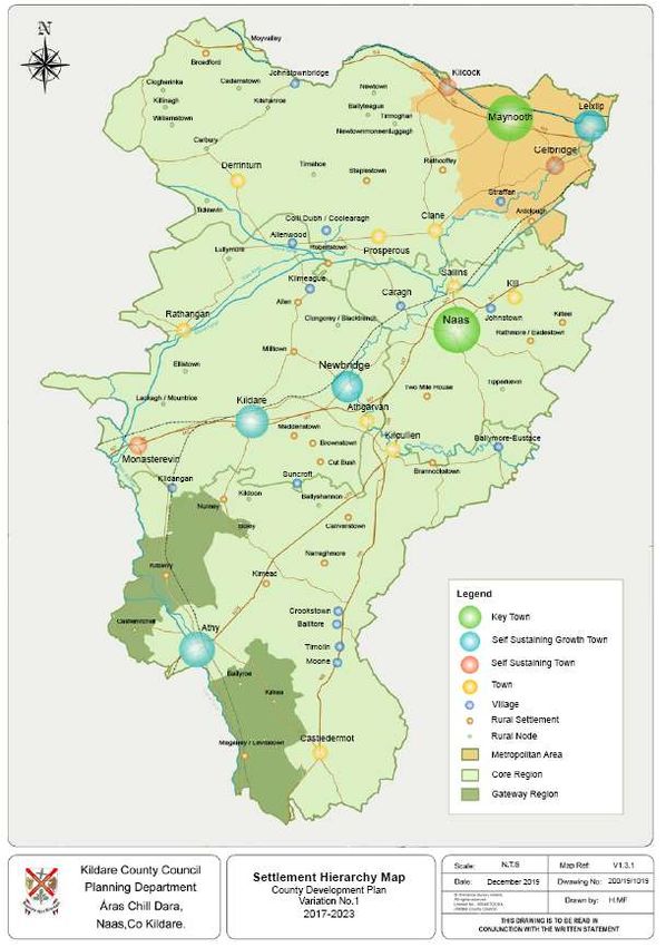
as the National Climate Change Strategy, the National Development Plan and the
Transport Strategy for the Greater Dublin Area 2016-2035.

(i)(a) Implementation Roadmap for The National Planning Framework (July 2018)
The Roadmap sets out the way forward by addressing a number of implementation
matters following the publication of the NPF.
Matters addressed in the Implementation Roadmap include:
   1) Legal Status and Project Governance;
   2) Enactment of legislation for the statutory underpinning of the NPF and alignment
         of County Development Plans;
   3) Regional Spatial and Economic Strategies (RSESs), including:
            a. Transitional Population Projections;
            b. Metropolitan Areas;
            c. Regional Centres – Plan Preparation;
   4) Urban and Rural Regeneration and Development Fund;
   5) The National Regeneration and Development Agency.

The Transitional Regional and County Population Projections to 2031 for the Mid-East
counties are as follows:

Table 1.1 Transitional Population Projections (Source: NPF Roadmap (July 2018) and RSES (June
2019).

                                                                                                4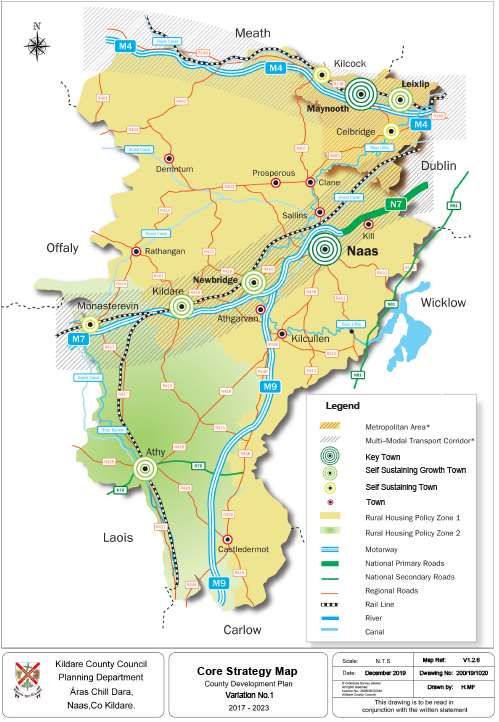
1.4.1 (i)(b) Office of the Planning Regulator
The Planning and Development (Amendment) Act 2018 provided for the establishment
of an independent Office of the Planning Regulator (OPR). Under the provisions of the
Act, the OPR has assumed the Minister’s evaluation and assessment function of all
statutory land use plans including development plans and local area plans. The OPR
will provide statutory observations during the drafting of statutory plans to ensure
consistency with relevant national and regional policies. Kildare County Council
undertakes to take all observations received from the OPR into consideration and
commits to working with the office to realise the most optimal planning and
development outcomes within each respective plan area.

                                                                                        5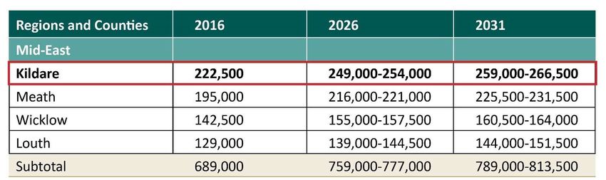
Amendment No. 3
Chapter Section Page(s)
Chapter 1: Introduction & Strategic Context Section 1.4.2(i) and 1.4.2(ii) 24-25
Amendment:
Delete Section 1.4.2 (i) Regional Planning Guidelines in its entirety and replace
with text in relation to Regional Spatial and Economic Strategy.
Delete Section 1.4.2(ii) concerning the Retail Strategy for the GDA in its entirety.
Amend numbering of subsequent sub-headings.
1.4.2 Regional Policies and Strategies
Regional policies and strategies provide the policy link between national policies and
guidance documents and local authority planning policies and decisions. The most
relevant are outlined in the following sections.
(i) Eastern & Midland Regional Spatial and Economic Strategy
The Regional Spatial and Economic Strategy (RSES) is a strategic plan and investment
framework to shape future development and to better manage regional planning and
economic development throughout the Region. The Strategy replaces the Regional
Planning Guidelines (RPGs) for the GDA. It identifies the Eastern and Midland Region’s
key strategic assets, opportunities and challenges and provides policy responses in the
form of Regional Policy Objectives, to ensure that people’s needs – such as access to
housing, jobs, ease of travel and overall well-being – are met.
The principal statutory purpose of the RSES is to support the implementation of Project
Ireland 2040 - The National Planning Framework (NPF) and National Development Plan
(NDP). Therefore, it provides a development framework for the region through the
provision of a Spatial Strategy, Economic Strategy, Metropolitan Area Strategic Plan
(MASP), Investment Framework and Climate Action Strategy.
The RSES will be implemented in policy by way of the County Development Plan and
Local Economic and Community Plans (LECP). The RSES will be realised by the
delivery of European and national funding that will achieve the Regional Strategic
Outcomes (and NPF National Strategic Outcomes) expressed in the Strategy. These
6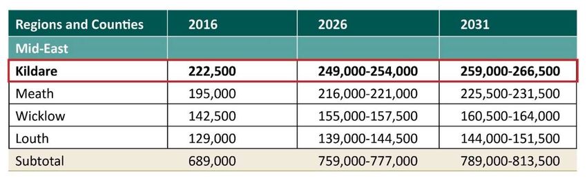
funds will focus on the priorities and key aspects of the RSES to sustainably grow the
Region to 2031 and beyond.

A Metropolitan Area Strategic Plan (MASP) forms part of the Strategy, which identifies
several large scale strategic residential and economic development areas, that will
deliver significant development in an integrated and sustainable manner in the
metropolitan area, of which the area of Maynooth, Leixlip, Celbridge and Kilcock forms
part (northeast of the county).

The Planning and Development Act 2000 (as amended) places an obligation on the
planning authority to prepare a ‘core strategy’ which shows that the development
objectives in the plan are consistent, as far as practicable, with national and regional
development objectives set out in the National Planning Framework and the Regional
Spatial and Economic Strategy. Chapters 2 and 3 set out the Core Strategy and
Settlement Strategy for County Kildare.

                                                                                           7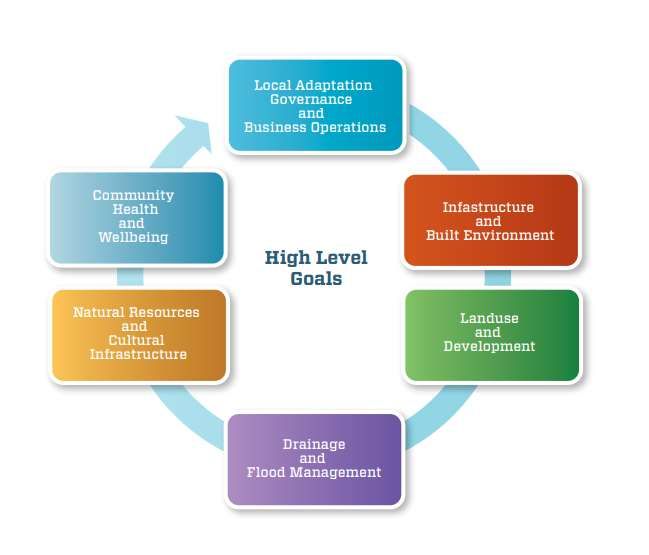
Amendment No. 4
Chapter Section Page(s)
Chapter 1: Introduction & Strategic Context Section 1.4.3 26-27
Amendment:
Insert a new Section 1.4.3 (iii) and amend subsequent numbering.
(iii) Climate Resilient Kildare: Kildare County Council Climate Change
Adaptation Strategy 2019 – 2024
This Strategy forms part of the National Adaptation Framework (NAF) which was
published in response to the provisions of the Climate Action and Low Carbon
Development Act 2015.
This Council’s Adaptation Strategy is the primary implementation instrument at local
level to:
Ensure a proper comprehension of the key risks and vulnerabilities of climate
change is attained.
Bring forward the implementation of climate resilient adaptation actions in a
planned and proactive manner.
Ensure that climate adaptation considerations are mainstreamed into all plans and
policies including the CDP and LAPs and integrated into all operations and
functions of the local authority.
(iv) Local Area Plans
In accordance with the Planning and Development Act 2000 (as amended), Local Area
Plans (LAPs) are required to be prepared for designated Census towns within the
county with a population over 5,000. Towns with a population of 1,500 also require
LAPs to be prepared, unless objectives for the area of the town are included within the
County Development Plan.
LAPs set out in greater detail the Council’s requirements for new development,
including such factors as density, layout and design requirements, community facilities,
8transportation, open space and recreational facilities. These plans must be consistent
with the County Development Plan.
Local Area Plans were adopted for Kilcock, Kilcullen, Kildare, Newbridge, Maynooth,
Monasterevin and Sallins during the course of the 2011-2017 County Development
Plan.
A number of small towns which previously had LAPs were incorporated into the County
Development Plan in 2012, by way of a variation. These are Kill, Prosperous,
Rathangan, Athgarvan, Derrinturn and Castledermot.
Kildare County Council will prepare Local Area Plans for Naas and Athy to provide
more detailed planning policies for these areas.
The local area plans will be set within the overall framework of the County Development
Plan including the Core Strategy and other overarching policies and development
management objectives and standards.
(v) Other Plans and Strategies
A number of other plans and strategies have been carried out which inform the
preparation of this Plan and include:
a) The County Heritage Plan 2019–2025 which outlines an action plan for the
conservation, preservation and enhancement of Kildare’s heritage including
natural heritage.
b) The County Biodiversity Plan 2009-2014 provides a framework for conserving
biodiversity and natural heritage at a local level. It consists of a number of
practical actions which serve to raise awareness of and enhance the protection,
conservation and management of our natural heritage.
c) The Kildare Age Friendly Strategy 2016-2018 aims to make Kildare a great place
to grow old. The strategy highlights that this can only be achieved through
maximum collaboration, cohesion and cooperation across groups and agencies.
Age friendly indicators developed by The World Health Organisation relate to the
health, care, transport, housing, labour, social protection, information and
9communication sectors. The policies and objectives of this plan promote an age
friendly county that enables people of all ages to actively participate.
10Chapter 2
Amendment No. 5
Chapter Section Page(s)
Chapter 2: Core Strategy Section 2.1 and 2.2 and 2.3.1.2 32
Amendment:
Amend Section 2.1 and 2.2;
Insert new Figure 2.1;
Amend numbering of Figure 2.1 to Figure 2.1 (a)
2.1 Statutory Context and Background
The Planning and Development (Amendment) Act, 2010 introduced a requirement for
an evidence based “Core Strategy” to form part of all Development Plans. The purpose
of the Core Strategy is to articulate a medium-to-longer term quantitatively based
strategy for the spatial development of the area of the planning authority and in doing
so to demonstrate that a development plan and its policies and objectives are
consistent with national and regional development objectives set out in the National
Planning Framework (2018), the Implementation Roadmap (2018) and the Eastern and
Midland Regional Assembly’s Regional Spatial and Economic Strategy (2019).
The Act requires a Core Strategy to include a settlement hierarchy; evidence-based
population and housing targets for all towns, villages and the open countryside; to
demonstrate how future development supports public transport and services; and to
demonstrate regard for the Retail Planning Guidelines for Planning Authorities, DECLG
(2012).
While the Act does not expressly require the Core Strategy to contain information
concerning other land uses such as employment and commercial zones, the Guidance
Note on Core Strategies, DECLG (2010) recommends that planning authorities
undertake an appropriate level of analysis to ensure that sufficient lands are zoned at
suitable locations, taking account of higher level planning policies and required physical
infrastructure.
11The Core Strategy should be represented in the written statement, by a diagrammatic
map or other such visualisations, and in the Core Strategy tables.
2.2 Strategy
In accordance with the Planning and Development (Amendment) Act, 2010, the first
Core Strategy for Kildare was set out in the 2011-2017 County Development Plan. The
Core Strategy in this Plan builds on the principles of the previous Strategy.
Chapter 2 Core Strategy and Chapter 3 Settlement Strategy set out an overarching
strategy for the development of the county to 2023 and beyond and translate the
strategic planning framework of the NPF and RSES to county level. The Core Strategy
addresses the period from Census 2011 to 2023 and incorporates population and
household figures from Census 2016 (CSO July 2016).
It is recognised that, as Kildare traverses the three designated areas, namely the Core
Region, the Metropolitan Area and the Gateway Region as per the Regional Spatial and
Economic Strategy it will be influenced by and have influence over future economic,
social and environmental trends in the region. The provides a broad planning
framework giving an overall strategic context to the development plans of each local
authority in the Eastern and Midland Region.
12Figure 2.1 Settlement Strategy for the Eastern & Midland Region
Source: Eastern & Midland Regional Assembly Regional Spatial & Economic Strategy
13This Development Plan seeks to encourage the focus of new development on:
(i) Consolidation within the existing urban footprint, by ensuring 30% of all new
homes are targeted within the existing built-up areas to achieve compact growth
of urban settlements;
(ii) Supporting the achievement of more sustainable climate resilient communities in
towns and villages through residential and employment opportunities with a
focus on sustainable urban regeneration and compact growth together with
supporting social and community facilities;
(iii) Supporting national investment in public transport services by focusing new
development areas in key locations to achieve the integration of land uses and
high-quality public transport provision;
(iv) Achieving economies of scale for services and infrastructure in identified growth
towns;
(v) Promoting economic development and employment opportunities within defined
Strategic Employment Development Areas in the North-West corridor of the
Metropolitan Area, in line with the overall Growth Strategy;
(vi) Facilitating development in the smaller towns and villages in line with the ability
of local services to cater for growth that responds to local demand;
(vii) Recognising the role of the rural countryside in supporting the rural economy
and its role as a key resource for agriculture, equine, bloodstock, forestry, energy
production, tourism, recreation, mineral extraction and rural based enterprises;
(viii) Supporting, facilitating and promoting the sustainable development of
renewable energy sources in the county;
(ix) Protecting local assets by preserving the quality of the landscape, open space,
recreational resources, natural, architectural, archaeological and cultural heritage
and material assets of the county;
(x) Promoting social inclusion and facilitating the delivery of objectives contained in
the Kildare Local Economic and Community Plan (LECP) 2016-2021.
Subsection 2.3.1.2 Population Density 2011
Amend Figure 2.1 to 2.1(a) Population Change per Municipal District 2006-2011 to
reflect additional map under Figure 2.1.
14Amendment No. 6
Chapter Section Page(s)
Chapter 2: Core Strategy Section 2.4, 2.5, 2.5.1, Map 2.3 & Table 2.2 38 - 40
Amendment:
Delete current text under Section, 2.4, 2.5 and 2.5.1 in its entirety and replace
with text at Section, 2.4, 2.5 and 2.5.1
Delete and replace Map 2.3
Delete and replace Table 2.2
2.4 Growth Strategy – Regional Context
The Regional Spatial and Economic Strategy (RSES) sets out the Settlement Hierarchy
for the Region, and identifies key locations for population and employment growth,
coupled with investment in infrastructure and services to meet those growth needs. An
evidence-led asset-based approach was used to inform the overall Growth Strategy
which is underpinned by the Settlement Hierarchy for the region.
The Growth Strategy for the Region:
- Supports the continued growth of Dublin as the national economic engine;
- Delivers sustainable growth of the Metropolitan Area through the Dublin
Metropolitan Area Strategic Plan (MASP). This includes Maynooth, Leixlip,
Celbridge, and Kilcock and their immediate surrounds;
- Supports rural areas with a network of towns and villages;
- Embeds a network of Key Towns - Naas and Maynooth in County Kildare -
through the region to deliver sustainable regional development;
- Supports the transition to a low carbon, climate resilient communities and a
healthy environment with high quality air and water.
2.5 Settlement Hierarchy – Regional Context
The Settlement Hierarchy provides for three distinct areas across the Eastern and
Midland Region comprising of the Dublin Metropolitan Area, the Core Region and the
Gateway Region. Located within the region are the Regional Growth Centres of
15Athlone, Drogheda and Dundalk which were identifed by the NPF and the Key Towns,
Naas and Maynooth, as recognised in the RSES. The other towns and villages in the
Settlement Hierarchy will be defined at local level through the Development Plan
(Table 2.3 refers).
County Kildare is predominantly located within the Core Region, with the exception of
the northeast of the county which is located in the Dublin Metropolitan Area and a
portion in the southwest of the county which forms part of the Gateway Region (refer to
Map 2.3).
The Dublin Metropolitan Area includes the highly urbanised settlements of Maynooth,
Leixlip, Celbridge and Kilcock which have strong connection to Dublin City and County.
A Metropolitan Area Strategic Plan is included in the RSES. Strategic Development
Areas have been identified at key nodes along high-quality public transport corridors in
tandem with the delivery of infrastructure and enabling services. In Maynooth, lands to
the south east at Railpark and to the north and west near the University have been
identified for strategic residential development in tandem with the new research and
technology zoning adjoining Maynooth University for strategic economic development.
In Leixlip, the former Hewlett Packard site and Collinstown site have been identifed as
strategic employment areas. The greenfield lands at Confey have also been identified
for residential development and mixed uses close to Confey Railway Station.
The Core Region includes the peri-urban ‘hinterlands’ in the commuter catchment
around Dublin. It contains a strong network of county and market towns that have a
good level of local employment, services and amenities, which serve their resident
populations and a wider catchment area. It is noted in the RSES that some areas have
emerged mainly as commuting towns, experiencing high rates of population growth but
with a weak level of services and functions for resident populations. These town’s will
require ‘catch up’ investment in local employment and services in order to become
more self-sustaining and to improve sustainable mobility, particularly in those places
where there are high levels of car dependency.
16Athlone Town has been identified as a Gateway Town with the potential to act as an
economic growth driver in the Midlands. The Athlone Gateway Region comprises of an
extensive network of county and sub county towns and small towns and villages, which
support the wider rural and agricultural area where the population is more dispersed. In
County Kildare a small section of the county along its south-western border is included
in the Gateway Region.
2.5.1 Settlement Hierarchy – Defining Principles
The principles governing the categorisation of each settlement type are summarised in
the following paragraphs followed by Table 2.2 which identifies the overall settlement
hierarchy for County Kildare.
Key Towns – large economically active service and/or county towns (Naas and
Maynooth) that provide employment for their surrounding areas and with high-quality
transport links and the capacity to act as growth drivers to complement the Regional
Growth Centres.
Self-Sustaining Growth Towns - Self-Sustaining Growth Towns with a moderate level
of jobs and services – includes sub-county market towns and commuter towns with
good transport links and capacity for continued commensurate growth to become more
self-sustaining.
Self-Sustaining Towns - Self-Sustaining Towns with high levels of population growth
and a weak employment base which are reliant on other areas for employment and/or
services and which require targeted ‘catch up’ investment to become more self-
sustaining.
Towns and Villages - Towns and villages with local service and employment functions.
Rural – Smaller villages and the wider rural region.
17There is continued considerable pressure for development of single homes in the rural
area across County Kildare. The National Planning Framework acknowledges that this
is a national issue and further acknowledges that in rural Ireland, many people seek the
opportunity to build their own homes but find it difficult to do so in smaller settlements
because of a lack of available sites and services. The NPF also states that in order to
assist this, local authorities will be supported in undertaking, the necessary land
acquisition, site preparation and local infrastructure provision to deliver self-build
development options in smaller towns/villages.
National Policy Objective (NPO) 18b of the NPF specifically makes provision to develop
a programme for ‘new homes in small towns and villages’ with local authorities, public
infrastructure agencies such as Irish Water and local communities to provide serviced
sites with appropriate infrastructure to attract people to build their own homes and live
in small towns and villages.
It is envisaged that the provision of serviced sites to create ‘build your own home’
opportunities within the existing footprint of rural settlements will provide an alternative
to one-off housing in the countryside. The development capacity of individual proposals
shall be controlled to 10-15% of the existing housing stock over the lifetime of the Plan
(VRS 6). Larger Schemes will only be considered where they relate to important
strategic sites (e.g. infill within the core of a village/settlement, or the redevelopment of
backlands) and will be contingent on the agreement of a masterplan and the agreement
of a phasing arrangement as per Policy VRS 6 contained in Volume 2, Section 2.4.
The following Map 2.3 illustrates the overall Growth Strategy for the region and
identifies the three distinct regions that County Kildare forms part including the location
of the Key Towns of Naas and Maynooth within the wider regional context.
18Map 2.3: EMRA Growth Strategy 2019 - 2031
Source: Eastern & Midland Regional Assembly Regional Spatial & Economic Strategy
19Table 2.2 Settlement Hierarchy & Typology County Kildare
Hierarchy Description Locations
Key Towns Large towns which are economically active that Naas
provide employment for their surrounding Maynooth
areas. High quality transport links and the
capacity to act as regional drivers to
complement the Regional Growth Centres.
Self- Moderate level of jobs and services. Newbridge
Sustaining Leixlip
Growth Towns Kildare Town
Athy
Self- High levels of population growth and a weak Celbridge
Sustaining employment base. Kilcock
Towns Monasterevin
Towns Local service and employment functions in Sallins
close proximity to higher order urban areas. Kilcullen
Kill
Clane
Prosperous
Rathangan
Athgarvan
Castledermot
Derrinturn
20Amendment No. 7
Chapter Section Page(s)
Chapter 2: Core Strategy Section 2.7 42
Amendment:
Amend text under Section 2.7.
2.7 Preferred Development Strategy
The preferred development strategy has been informed by RSES and the
environmental sensitivities of the county. It is based on building strong urban centres
while protecting the rural hinterlands. The focus is on achieving:
- Critical mass in the Metropolitan Area Strategic Plan (MASP) area (Maynooth,
Leixlip, Celbridge, Kilcock) and in the Key Towns of Naas and Maynooth;
- Measured growth with emphasis on economic growth in the towns identified as
Self-Sustaining Growth Towns and Self-Sustaining Towns as per Table 2.2;
- Establishing a hierarchy of smaller rural settlements to develop rural centres
capable of providing a range of services and employment to their local
populations;
- Managing development in rural areas with a focus on agricultural diversification,
appropriate rural enterprise (e.g. renewable energy production) and the
strengthening of existing towns and villages;
- Protecting the environment by implementing an environmental protection policy
which recognises the various environmentally sensitive zones within the county
but not to mutually exclude appropriate and otherwise acceptable uses and
development.
21Amendment No. 8
Chapter Section Page(s)
Chapter 2: Core Strategy Section 2.8, 2.9, Table 2.3, 2.4, Figure 2.3, 43 - 45
2.4
Amendment:
Delete text under Section 2.8 in its entirety
Delete current Table 2.3 and Table 2.4 in their entirety
Insert new text under Section 2.8;
Insert new Table 2.3; Population Projections to 2031
Insert new Table 2.4; Population and Housing Targets
Delete text under Section 2.9 in its entirety
Delete Figure 2.3 and Figure 2.4 in their entirety
Amend Section 2.9 to remove & replace with new text
2.8 Population and Housing Growth
The Implementation Roadmap for the National Planning Framework provides for
transitional regional and county population projections to 2031 as illustrated in Table
2.3.
Table 2.3 Population Projections to 2031
Source: NPF Roadmap (July 2018) & RSES {EMRA} (June 2019)
The above figures for Kildare provide for a population range for the period 2026 and
2031. Taking the higher range for each year the county population is projected to
increase by 31,500 persons to 2026 with an additional 12,500 to the year 2031.
22The NPF Roadmap population projections already incorporate headroom figures for all
parts of the country. However, in certain counties of which Kildare is one, the Council
may provide for an additional 25% headroom with regards to the figures, where
projected population growth is projected to be at or above the national average
baseline.
Table 2.4 illustrates the population figures represented as housing targets for the period
2016 to 2023.
Table 2.4 Population and Housing Targets – County Kildare
Census Census NPF 2026 NPF 2026 Population Dwellings
2016 2016 Pop Growth growth growth 2020 Target 2020
Pop Dwellings (with 25% target in to 20231 to 2023
increase) units
222,5042 80,746 39,370 14,0603 16,863 6,023
2.9 Distribution of Growth and Housing Land Capacity Distribution of Growth
Growth targets have been allocated to towns, villages and settlements based on the
NPF Implementation Roadmap and the RSES. Chapter 3 sets out the allocation of
housing in more detail. Section 3.5, Table 3.3 sets out growth targets for towns,
villages, rural settlements, rural nodes and the open countryside during the Plan period,
based on a requirement for 6,023 housing units.
Housing Land Capacity
The capacity of settlements in Kildare to accommodate the level of growth envisaged by
the NPF and to deliver sustainable communities that are well served by social and
physical infrastructure will need to be carefully considered as part of the Local Area
Plan process for the relevant towns. For villages and rural settlements, the Plan states
in Volume 2 that population growth of Villages should not grow beyond 25% of the
1 See also footnote associated with Table 3.3 regarding methodology
2 NPF implementation Roadmap rounded the population figure down.
3 Occupancy Rate of 2.8 applied as per 2016 Census.
23Census 2016 population with a growth of 20% for Rural Settlements over the period of
the plan.
24Amendment No. 9
Chapter Section Page(s)
Chapter 2: Core Strategy Section 2.11, 2.11.1-2.11.6 46
Amendment:
Amendments to Section 2.11;
Text amendments to Section 2.11.1 – 2.11.6 with additional sub-section to
increase to 2.11.8
2.11 Overall Economic Strategy
The strategy for the future economic development of the county is set out in Chapter 5
and is informed by the NPF, RSES, and the Local Economic and Community Plan
(LECP) prepared by the Kildare Local Community and Development Committee in
2015. The focus will be on developing the Key Towns to act as economic drivers and
provide for strategic employment locations supported by the regionally important self-
sustaining growth towns and self-sustaining towns. The development of the part of
Kildare in the MASP area will support the future growth of the Metropolitan Area
through the strategic development of the North-West corridor which has been identified
through MASP along the Maynooth/Dunboyne commuter line/DART.
2.11.1 Key Towns
Naas and Maynooth are identified as Key Towns. They have the potential to
accommodate commensurate levels of population and employment growth, facilitated
by their location on public transport corridors and aligned with requisite investment in
services, amenities and sustainable transport. The growth of the Key Towns will require
sustainable, compact and sequential development and urban regeneration in the town
core.
2.11.2 Economic Clusters
Economic clusters are also promoted as part of the overall economic strategy. Naas is
clustered with Newbridge and Kilcullen while Maynooth is clustered with Leixlip,
Celbridge and Kilcock. Clusters are to develop in a mutually dependent way, so that the
25amenities and economies of the whole cluster are greater than the sum of the individual
parts.
2.11.3 Self-Sustaining Growth Towns
Newbridge, Leixlip, Kildare and Athy have been designated as Self-Sustaining Growth
Towns. The RSES define these towns as those with a moderate level of jobs and
services, which adequately cater for the people of its service catchment with good
transport links and capacity for continued commensurate growth.
2.11.4 Self-Sustaining Towns
Celbridge, Kilcock and Monasterevin are identified as Self-sustaining Towns. The
RSES describe these settlements as those with high levels of employment growth and
a weak employment base which are reliant on other areas for employment and/or
services and which require targeted ‘catch-up’ investment to become more self-
sustaining. Accordingly, these towns require contained growth, focusing on driving
investment in services, employment growth and infrastructure while balancing housing
delivery. Growth shall be focused on consolidation and inclusion of polices in relation to
improvements in services and employment provision.
2.11.5 Towns
Sallins, Kilcullen, Kill, Clane, Prosperous, Rathangan, Athgarvan, Castledermot and
Derrinturn are designated as towns. They contain local service and employment
functions such as convenience retail and are proximate to larger urban centres. The
Council will seek to support new local employment opportunities in these towns.
2.11.6 Villages
The villages of Johnstown, Straffan, Ballymore Eustace, Allenwood, Johnstownbridge,
Coill Dubh/Coolearagh, Kilmeague, Caragh, Kildangan, Suncroft, Robertstown,
Ballitore, Crookstown, Moone, and Timolin located in rural settings will seek to supply
new local employment opportunities, while also addressing decline, with a special focus
on activating the potential for their renewal and development.
262.11.7 Rural Areas
Within the rural areas there are clear locational requirements for employment
generating uses including, but not limited to, green energy projects such as renewable
energies and resource recovery, but also food production, agri-business, quarrying,
forestry, bloodstock, horticulture and rural based tourism.
27Amendment No. 10
Chapter Section Page(s)
Chapter 2: Core Strategy Section 2.15, 2.16.1, 2.16.2 and 2.14.5 47 and 48
Amendment:
Amend text under Section 2.15 to 2.14.54;
Correct clerical error in numbering relating to Section 2.14.5.
2.15 Climate Change
The National Climate Change Adaptation Framework ‘Building Resilience to Climate
Change’ was published by the Department of the Environment, Community and Local
Government in 2012. Kildare County Council co-hosts the Climate Action Regional
Office (CARO) leading 17 local authorities in the region. Kildare County Council has
published a Climate Change Adaptation Strategy 2019 – 2024. This will inform policy
making at a county and local level in the future.
The purpose of the Adaptation Strategy is to:
Ensure that a proper understanding of the key risks and vulnerabilities of climate
change is attained.
Bring forward the implementation of climate resilient adaptation actions in a
planned and proactive manner.
Ensure that climate adaptation considerations are mainstreamed into all plans
and policies and integrated into all operations and functions of the local authority.
The Strategy comprises of six high levels goals which will be embedded in all the
functions and services of Kildare County Council as follows:
4
Please note numbering sequencing error in the adopted Kildare County Development Plan 2017 - 2023
28Source: Climate Resilient Kildare: Climate Change Adaptation Strategy 2019-2024
The County Development Plan seeks to promote a series of policies and objectives
throughout that will ameliorate the effects of climate change and introduce resilience to
its effects to support the implementation of the National Climate Change Strategy 2007-
2012, DEHLG (2007) and the National Climate Change Adaptation Framework Building
Resilience to Climate Change, DECLG (2012).
2.16 Delivering the Core Strategy
2.16.1 Policies: Settlement Strategy
It is the policy of the Council to:
CS 1 Provide new housing in accordance with the County Settlement Hierarchy.
CS 2 Direct appropriate levels of growth into the designated growth towns as
designated in the Settlement Strategy.
CS 3 Support rural communities through the identification of lower order centres
including towns, villages and settlements to provide more sustainable
development centres in the rural areas.
29CS 4 Deliver sustainable compact urban areas through the regeneration of towns and
villages through a plan-led approach which requires delivery of a least 30% of all
new homes that are targeted in these settlements to be within their existing built
up footprint.
CS 4(a)Develop in accordance with the National Planning Framework (NPO 18b) a
programme for new homes in small towns and villages in association with public
infrastructure agencies, local communities, housing bodies and landowners to
identify lands for the provision of low density serviced sites with appropriate
infrastructure throughout settlements identified as Rural Towns, Villages and
Rural Settlements (as identified in Table 3.3).
2.16.2 Policies: Economic Development
It is the policy of the Council to:
CS 5 Support the development of the identified Key Towns of Naas and Maynooth and
the Self-sustaining Growth Towns of Leixlip and Newbridge as focal points for
regional critical massing and employment growth
CS 6 Encourage and facilitate new employment opportunities which improve the
cluster-specific business environment.
CS 7 Promote targeted ‘catch up’ investment to support self-sustaining local
employment, and in services, sustainable transport and amenities in places that
have experienced rapid commuter driven population growth
CS 8 Address commuting patterns by building up the local economy to a more
sustainable level by promoting self-sustaining employment-based development
opportunities in settlements to provide for employment growth for the existing
population in order to reverse commuting patterns.
2.16.5 Policies: National Climate Change Strategy
It is the policy of the Council to:
CS 16 Support the implementation of the National Climate Change Strategy and the
National Climate Change Adaption Framework Building Resilience to Climate
Change 2012 through the County Development Plan and through the
implementation of the Climate Resilient Kildare: Climate Change Adaptation
30Strategy 2019 – 2024 in conjunction with all relevant stakeholders. Ensure that
climate action considerations are integrated into land use planning and aid the
transition to a climate resilient low carbon society, promoting and maximising the
most efficient and sustainable use of land.
31Amendment No. 11
Chapter Section Page(s)
Chapter 2: Core Strategy Section 2.16 49
Amendment:
Delete Map 2.6 Core Strategy Map and replace with a revised map.
Map 2.6 Core Strategy Map
32Chapter 3
Amendment No. 12
Chapter Section Page(s)
Chapter 3: Settlement Strategy Section 3.1, 3.2, 3.3, 3.4, Table 3.1, 52 -55
Map 3.1.
Amendment:
Amend text under Section 3.1, Section 3.2 and Section 3.3
Replace Table 3.1 County Kildare Settlement Hierarchy 2011 -2017
Delete and replace Map 3.1 Settlement Hierarchy map
Replace text under Section 3.4
Deletion of Section 3.4.1 – 3.4.4 & renumber subsections accordingly
3.1 Background
A settlement strategy is a spatial expression of population distribution, settlement size,
settlement role and settlement hierarchy. The settlement strategy in this Plan provides a
strategic direction to the management of growth, investment and resources in
accordance with the core strategy outlined in Chapter 2.
This chapter accords with the over-arching strategic policies of the National Planning
Framework (NPF) and the Eastern Midland Regional Spatial and Economic Strategy
2019-2031 (RSES) whilst having regard to key planning considerations including
infrastructure provision and environmental protection. This Plan proposes a structured
approach to spatial planning and a settlement strategy founded on a well-developed
urban structure supporting diverse rural areas.
The strategy is based on the consideration of environmental sensitivities, survey work
and the level of existing and proposed physical and social infrastructure. It seeks to
strengthen the urban fabric of the county, with an emphasis on building critical mass in
Key Towns. Rural populations will continue to be supported through the settlement
centres and through a sustainable approach to maintaining rural
economy and population balanced against responsible environmental protection.
333.2 Setting the Context
The diversity of County Kildare requires a settlement strategy designed to sustain a
healthy network of settlements across the Dublin Metropolitan Area, the Core Region
and the Gateway Region areas of the county.
An examination of the dynamics and distribution of population and settlement within the
county for the period 2011-2016 indicates the following key trends:
- The period showed continued increase in population albeit at a slower rate than
previously with 5.8% growth in the five-year period since 2011 (an additional
12,192 people). This was the third highest rate of growth in the State and was
well in excess of the State average of +3.8% and marginally higher than the rate
of growth in EMRA (+5.4%) and the Eastern regional average (+5.3%).
- Continued pressure for development at the edges of the County’s main urban
centres and in the adjoining rural hinterlands.
- A limited number of areas experienced population stagnation including north of
Rathangan, Newbridge town centre, Pollardstown, Ballysax, south of Maganey
and Tipperkevin.
- Between 2011 and 2016, a total of 13 of the 89 Electoral Divisions (EDs) in
Kildare witnessed population decline. Highest increases in population were
recorded in Naas Rural (+16.3%), Maynooth (+16.8%), Straffan (+19.2%) and
Oldconnell (+22.7%).
- The draw of Dublin as an employment hub, with 39.1% of the workforce leaving
Kildare for employment, is reflected in the County’s settlement pattern. Higher
population densities are located in the Metropolitan northeast and within and
around the towns of Naas, Newbridge, Athy, Kildare, Monasterevin and Kilcullen.
- Between 2009 and 2013 rural one-off dwellings accounted for 40% of all builds in
Kildare. This high figure reflected the relatively low level of construction within
the urban areas of Kildare due to the economic downturn and capacity
/infrastructural issues within the Osberstown wastewater treatment catchment.
An average of 264 rural dwellings were built per annum in Kildare between 2009-
2015. This has consolidated a pattern of dispersed rural development.
343.3 Settlement Hierarchy
A settlement hierarchy is set out to underpin decisions regarding the location and scale
of new developments such as housing, employment creation and social and physical
infrastructure provision. Investment in infrastructure should be focused on
locations that are the most environmentally robust and provide the best economic
return.
National and regional planning policy documents referenced in Section 1.4.1 of this
Plan and the environmental sensitivities referred to in Section 2.6 have informed the
Preferred Development Strategy for the county, as detailed in Section 2.7. The
Preferred Development Strategy forms the basis for the settlement hierarchy.
An analysis of the capacity of towns and villages throughout the county to
accommodate future growth has been undertaken. The key issues examined in
determining the capacity of each settlement for development include the following:
- Strategic Environmental Assessment of this Plan;
- EMRA Regional Spatial and Economic Strategy 2019-2031;
- Existing population base;
- Level of social infrastructure;
- Level of physical infrastructure;
- Environmental constraints;
- Settlement form; and
- The Sustainable Residential Development in Urban Areas and accompanying
Urban Design Manual, DECLG (2009).
Arising from the foregoing considerations, the Settlement Hierarchy for County Kildare
is outlined in Table 3.1. A total of 74 settlements are identified ranging from Key Towns
to Rural Nodes. Map 3.1 illustrates the Settlement Hierarchy. The key principles
governing the role of each settlement category are set out in Section 3.4.
35(Replace Table 3.1 with as follows:)
Table 3.1 County Kildare Settlement Hierarchy 2020-2023
Settlement Category Designated Settlement
Key Towns Naas, Maynooth
Self-Sustaining Newbridge, Leixlip, Kildare Town, Athy
Growth Towns
Self-Sustaining Towns Celbridge, Kilcock, Monasterevin
Towns Sallins, Kilcullen, Kill, Clane, Prosperous, Rathangan,
Athgarvan, Castledermot, Derrinturn
Villages Johnstown, Straffan, Ballymore-Eustace, Allenwood,
Johnstownbridge, Coill Dubh/Coolearagh, Kilmeague,
Caragh, Kildangan, Suncroft, Robertstown,
Ballitore/Timolin/Moone/Crookstown
Rural Settlements Broadford, Milltown, Kilteel, Staplestown, Ardclough,
Allen, Brannockstown, Twomilehouse, Brownstown,
Cutbush, Maddenstown, Nurney, Calverstown,
Rathcoffey, Narraghmore, Maganey/Levitstown,
Kilmead, Kilberry
Rural Nodes Clogherinka, Cadamstown, Kilshancoe, Newtown,
Tirmoghan, Carbury, Timahoe, Lackagh/Mountrice,
Ballyshannon, Ballyroe, Kilkea, Ellistown,
Moyvalley, Rathmore/Eadestown,
Newtownmoneenaluggagh, Kildoon, Booleigh,
Castlemitchell, Williamstown, Clongorey/Blacktrench,
Ballyteague, Lullymore, Ticknevin, Tipperkevin, Killina
36Map 3.1 Settlement Hierarchy Map
373.4 Designated Role of Settlement Category
Within the Settlement Hierarchy each settlement category has a designated role which
is underpinned by its position in the overall growth strategy for the county. Maynooth
and Naas have been designated as Key Towns in the RSES. Decisions were made for
the remaining designations in the hierarchy by undertaking an economic analysis of all
towns to assess their performance, thereby providing an evidence-based assessment
on their position within the hierarchy.
The Settlement Hierarchy contained within the Plan aligns with the Regional Growth
Strategy and the role of each town within the hierarchy is detailed in Section 2.11
Overall Economic Strategy of this Plan, which outlines the designations for Self-
sustaining Growth Towns, Self-sustaining Towns along with town and villages.
3.4.1 Role of Rural Settlements and Rural Nodes
Rural Settlements and Rural Nodes are located throughout the county. It is proposed
that settlements will develop as local centres for rural catchments with growth
appropriate to cater for local demand. Lower densities will be encouraged in appropriate
locations. Expansion will be controlled to minimise pressure on services, the
environment and unsustainable commuting patterns. Rural Settlements have a higher
order function than Rural Nodes. Rural Nodes comprise largely unserviced areas with
limited social and community infrastructure and will accommodate limited development
at a sustainable scale for local demands by way of small-scale cluster developments.
The planning framework for future development of the rural settlements is detailed in
Volume 2, Section 2. Planning policy for future development in Rural Nodes is detailed
in Chapter 4.
3.4.2 Sequential Approach
All towns, villages, settlements, rural nodes (as appropriate) should be developed in a
sequential manner, with suitable undeveloped lands closest to the core and public
transport routes being given preference for development in the first instance. Zoning
shall extend outwards from the centre of an urban area with strong emphasis placed on
38encouraging infill opportunities. Areas to be zoned should generally be contiguous to
existing zoned development lands.
39Amendment No. 13
Chapter Section Page(s)
Chapter 3: Settlement Strategy Section 3.5, Table 3.2 & 3.3 56 - 60
Amendment:
Amend Section 3.5;
Delete Table 3.2 Housing Allocation 2016-2023;
Delete and replace Table 3.3 Population and Housing Allocation;
3.5 Housing and Population Allocation
Chapter 2 outlines the NPF Implementation Roadmap and RSES population projections
for the County for the periods 2020-2026 and 2026-2031. The projections have been
adjusted to the end of the first quarter of 2023, to coincide with the life of this Plan.
The population projection for Kildare to the end of the Plan period is 238,993, giving rise
to the need for 6,0235 additional residential units by 2023.
Table 3.3 lists the percentage allocation of growth in the various towns, villages and
settlements in Kildare. It is acknowledged that Maynooth is designated as a Key Town
in the Regional Spatial and Economic Strategy for the Eastern and Midlands Region,
and also forms part of the north-west corridor area under the Metropolitan Area
Strategic Plan (MASP) and provides significant levels of employment through Maynooth
University, the M4 Business Park and other businesses. It is also recognised that the
town is served by high capacity public transport which will continue to improve with the
electrification of the railway line over the next 6-8 years. The population of the town in
2016 was 14,585 with a housing stock of 5,171 units.
The town has experienced significant levels of new residential development both in
private housing and student accommodation over the past 5 years and with extant
permissions and pipeline developments, will see these levels continue for the next 3
years. New housing development on the Dunboyne, Celbridge and Dublin Roads
5 Giving an occupancy rate of 2.8
40provide for an additional 1,400 units and the proposed new neighbourhood at Railpark
which will be facilitated by the LIHAF (Local Infrastructure Housing Activation Fund)
funded Maynooth Eastern Relief Road will deliver between 800 and 900 units. There is
further potential for the consolidation of the town through the redevelopment of a
number of town centre sites. The delivery of these additional 2000+ units will result in a
38.6% increase in housing stock over a relatively short period of time. In order to allow
these developments to be realised and for the town to continue to develop at a
sustainable rate it is proposed that Maynooth will retain its current county allocation of
10.9%. Such a provision over the short-term (for the duration of this CDP up to 2023)
will provide an opportunity for the town to absorb recent and pipeline developments. In
allowing this ‘absorption period’, the Council will also be in a position to identify other
social and physical infrastructure needs (through the preparation of an infrastructural
assessment in accordance with Appendix 3 of the NPF) which will inform the
sustainable development of the town into the future.
This Plan also acknowledges Regional Policy Objective 4.35 of the RSES which
requires Kildare County Council to prepare a Joint LAP for Maynooth with Meath
County Council in order to deliver a coordinated planning framework for the town.
41Table 3.3 Settlement Hierarchy – Population and Housing Unit Allocation 2020-2023
Settlement Towns / Villages 2016 2016 Allocated NPF 2026 NPF 2026 Population Dwellings
Type Census Dwellings Growth Pop Pop Growth Target 2020
Pop (%) 2020- Growth Growth in 2020 to to 2023
2023 in housing 2023
persons units (annualised
from 2026
NPF
Figures)6
Key Town Maynooth (MASP7) 14,585 5,171 10.9% 4,291 1,533 1,839 657
Naas 21,393 7,726 14.9% 5,866 2,095 2,514 898
Self- Newbridge 22,742 8,260 11.6% 4,567 1,631 1,957 699
Sustaining Leixlip 15,504 5,524 10.2% 4,016 1,434 1,721 615
Growth Kildare 8,634 3,158 4.7% 1,850 661 793 283
Town Athy 9,677 4,281 4.8% 1,890 675 810 289
Self- Celbridge 20,288 6,969 10.0% 3,937 1,406 1,687 603
Sustaining Kilcock 6,093 2,212 4.0% 1,575 562 675 241
Town Monasterevin 4,246 1,706 2.6% 1,024 366 439 157
Sallins 5,849 2,071 1.9% 748 267 321 114
Kilcullen 3,710 1,401 2.5% 984 352 422 151
Kill 3,348 1,227 1.3% 512 183 219 78
Clane 7,280 2,741 2.4% 945 337 405 145
Town Prosperous 2,333 813 1.0% 394 141 169 60
Rathangan 2,611 1,009 0.9% 354 127 152 54
Athgarvan 1,176 373 0.7% 276 98 118 42
Castledermot 1,475 622 0.5% 197 70 84 30
Derrinturn 1,602 558 0.6% 214 76 92 33
Villages Johnstown (1,004), Straffan (635), Ballymore 10,327 3,105 3.7% 1,457 520 624 223
Eustace (872), Allenwood (845),
Johnstownbridge (650), Coill Dubh (687),
Coolearagh (384), Kilmeague (997), Caragh
(882), Kildangan (470), Suncroft (735),
Roberstown (669), Ballitore (556), Crookstown
(129), Moone (144), Timolin (96)
Rural Broadford (45), Milltown (177), Kilteel (163), 3,126 1,999 1.3% 512 183 219 78
Settlements Staplestown (98), Ardclough (153), Allen (62),
Brannockstown (186), Twomilehouse (263),
Brownstown (456), Cutbush (246),
Maddenstown (141), Nurney (342),
Calverstown (459), Rathcoffey (170),
Narraghmore (229), Maganey/Levitstown (69),
Kilmead (258), Kilberry (163)
Rural Nodes Clogherinka, Cadamstown, Kilshancoe, 56,385 19,068 0.5% 197 70 84 30
Newtown, Tirmogham, Carbury, Timahoe,
Lackagh/Mountrice, Ballyshannon, Ballyroe,
Kilkea, Ellistown, Newtownmoneenaluggagh,
Kildoon, Booleigh, Castlemitchell,
Williamstown, Clongorey/Blacktrench,
Ballyteague, Lullymore, Ticknevin, Tipperkevin
& Killna, Moyvalley, Rathmore/Eadestown
Rural 8.0% 3,150 1,125 1,350 482
Dwellers
Blessington 453 164 1.0% 141 169 60
Environs
County Total 222,504 80,158 14,060 16,863 6,023
6
Growth projections based on 7-year period between 2020 & 2026. 7-year methodology provides for ca. 16,863 persons (6,023 housing units) over the remainder of the plan (2020,
2021 and 2022 as the plan expires in early 2023) with ca. 22,507 persons (8,038 housing units) over the remaining 4 years to the end of 2026 which anticipates ca. 2,000 units per
year over the 7 years period which is considered to be a sustainable rate of growth and reasonable rate of housing delivery. The upcoming review of the CDP will also benefit from
the data from the Census in 2021 which will provide up to date figures in terms of population growth, housing stock and occupancy rates.
7
Section 5.7 of the RSES states that ‘There is a further allowance of transition population targets in NPO 68 by way of up to 20% of the targeted growth in the city being transferred
to other settlements in the MASP. This shall apply only to the three metropolitan Key Towns in the MASP namely Bray, Maynooth, and Swords and only if they can demonstrate
compact growth on high capacity planned or existing public transport corridors. Any further allocation will be considered by Kildare County Council on direction from the Eastern
Midlands Regional Assembly following agreement of its members. Subsequently, there will be a redistribution of the Maynooth population to 2031 in the Settlement Hierarchy
(table 3.3) across Key Towns, Self-sustaining Growth Towns and Self-sustaining Towns along the Dublin – Cork and Dublin – Waterford Rail Corridors to support the sustainable,
balanced and economic growth of the County.
42Amendment No. 14
Chapter Section Page(s)
Chapter 3: Settlement Strategy 3.6 and Table 3.4 63 - 64
Amendment:
Amend text under section 3.6 Development Capacity;
Delete Table 3.4 Development Capacity in Kildare.
3.6 Development Capacity
In order to implement the settlement strategy of this Plan, an understanding of the
existing development capacity within each of the designated towns and villages is
required. It should also be noted that the relevant requirements of the Habitats
Directive and the River Basin Management Plans and Flood Risk Assessment may
also impact on the development potential of particular areas.
Sufficient land is zoned to cater for the housing demands of the county up to 2023
and beyond, some Towns, Villages and Settlements have surplus capacity relative to
the Core Strategy allocation and some have a shortfall. The zoning surpluses and
shortfalls will be reviewed through the relevant land use plans. In this regard, there
shall be no presumption in law that any land zoned in a particular development plan
(including a development plan that has been varied) shall remain so zoned in any
subsequent development plan (Section 10(8) of the Planning and Development Acts
2000 (as amended) refers). Alternative land use zonings will be considered in the
first instance to address surplus residential zoning. In the event that surplus zonings
are retained the development of lands will be subject to a sequential phasing
approach, with phases extending outwards from the town or village core to more
peripheral lands.
The zoning of land in any forthcoming land use plan shall comply with the
requirements as detailed in Appendix 3 of the NPF relating to a methodology for a
tiered approach to land zoning. This methodology requires that land should not be
zoned for development unless there is existing service capacity available (Tier 1) or
64the lands have the potential to become fully serviceable (Tier 2) during the life of the
plan. Land use plans shall therefore contain a detailed Infrastructural Assessment for
residential land that provides for an evidence-based approach to the servicing of
potential sites to establish their suitability for zoning. However, infrastructural
availability is not the sole determining factor in decisions on land zoning. There are
other planning considerations such as the overall planned levels of growth, location,
suitability for the type of development envisaged, availability of and proximity to
amenities, schools, shops or employment, accessibility to transport services etc. The
NPF states weighing up all of these factors, together with the availability of
infrastructure, will assist planning authorities in determining an order of priority to
deliver planned growth and development (NPF, 2018). The NPF also requires that
land use plans (in respect of County Kildare) deliver 30% of all new housing within
the existing built-up footprints of urban settlements. The built-up footprints have been
defined by the CSO in the Census of Population and relate to a minimum of 50
occupied dwellings with a maximum distance between any dwelling and the building
closest to it of 100 metres, where there is evidence of an urban centre.
Volume 2 of this plan sets out a planning framework for the future development of
each of the Small Towns, Environs, Villages and Rural Settlements. Section 1 sets
out the planning framework towns with a population of under 5,000 people (Kill,
Prosperous, Rathangan, Athgarvan, Derrinturn and Castledermot). The other towns
above 5,000 people require a mandatory local area plan. The Settlement Strategy as
detailed in Table 3.3 contains the allocated growth for each of these settlements and
supersedes that which is produced in Volume 2. Section 2 sets out the land use
strategy for the Villages and Rural Settlements.
The Development Capacity of the Villages and Rural Settlements are detailed in
Section 2.4 of Appendix 2, Volume 2 of the Plan. The population growth of Villages
should not grow beyond 25% of the Census 2016 population with a growth of 20%
for Rural Settlements. It is envisaged that the provision of serviced sites to create
‘build your own home’ opportunities within the existing footprint of rural settlements.
The development capacity of individual proposals shall be controlled to 10-15% of
the existing housing stock over the lifetime of the Plan. Larger Schemes will only be
considered where they relate to important strategic sites (e.g. infill within the core of
65You can also read