Windermere Road, Annan Masterplan - Planning Guidance - November 2019 LOCAL DEVELOPMENT PLAN 2 - Dumfries and ...
←
→
Page content transcription
If your browser does not render page correctly, please read the page content below
Dumfries and Galloway Council
                      LOCAL DEVELOPMENT PLAN 2

                    Windermere Road,
                    Annan Masterplan
                     Planning Guidance - November 2019

www.dumgal.gov.uk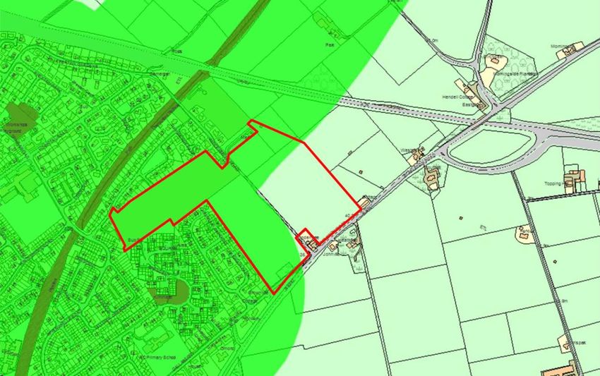
DUMFRIES AND GALLOWAY LOCAL DEVELOPMENT PLAN 2
            SUPPLEMENTARY GUIDANCE

             WINDERMERE ROAD, ANNAN MASTERPLAN

CONTENTS
 1. Introduction                                   2

 2. Vision                                         3

 3. Site Analysis                                  4
           Wider neighbourhood and context         4
           Site location and description           5

 4. Site Opportunities and Constraints             8

 5. Relevant Policies and Guidance                 9

 6. Development Principles
          6.1  Land Use                           10
          6.2  Development form                   10
          6.3  Housing mix and house types        10
          6.4  Density                            11
          6.5  Site frontages                     11
          6.6  Energy efficiency                  11
          6.7  Affordable housing                 12
          6.8  Access                             12
                       Pedestrians and cyclists   13
                       Public transport           13
          6.9  Roads Infrastructure               13
                       Transport assessment       13
                       Hierarchy of streets       13
                       Traffic                    14
          6.10 Open Space                         15
          6.11 Landscaping                        19
          6.12 Servicing                          20

 7. Developer Contributions                       21

 8. Phasing Plan                                  22

 9. Section 75 Planning Obligation                25

 10. Status of Masterplan                         25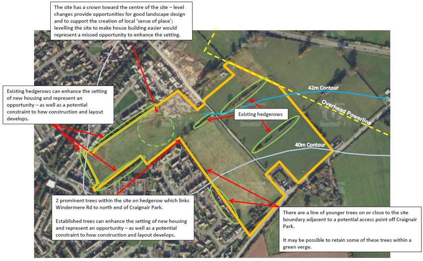
1 Introduction
1.1    This Masterplan has been prepared in conjunction with Dumfries and
Galloway Council’s Planning Service in order to assist in achieving the successful,
sustainable development of the whole site in accordance with planning policy and
guidance. It was initially adopted in December 2014 and updated following the
adoption of the Local Development Plan 2 in September 2019. Nothing in this
Masterplan can or should be taken to indicate the Council’s support or otherwise for
any future planning application or any other matter where the Council is acting in any
statutory capacity.

1.2   This Masterplan sets out the overall development concept, the main planning
and design principles on which development of the site will be based and the
approach to be adopted for a wide range of key components to ensure a successful
development.

1.3    The site will be developed in phases over a period of at least 10 – 20 years so
the aim of this Masterplan is to help deliver a high quality of development and ensure
the development, as a whole, accords with local and national policy and that
development of no part of the allocated housing sites are prejudiced or restricted.

1.4    The Masterplan provides a structured approach and the context within which
future planning applications for the individual phases will be developed, and against
which they will be assessed, as well as setting out how the design and consultation
process has progressed to date and how it is likely to evolve. Once the Masterplan
has been adopted by the Council it becomes part of the development plan for the
purposes of assessing planning applications.

1.5     The Masterplan specifically provides a framework for the development of this
site in relation to the following:

   •   Roads layout
   •   Open space and landscaping strategy and provision
   •   Affordable housing provision
   •   Density and housing distribution / phasing
   •   Drainage and SuDs scheme
   •   Design approach
   •   Integration with existing development
   •   Developer contributions
2 Vision
2.1     To create a high quality, sustainable and deliverable residential
neighbourhood as an extension to the existing settlement of Annan. It will help cater
for the town’s anticipated growth and housing need over the next 10-20 years and
support and help sustain existing services, facilities and assets in the immediate
locality and wider settlement.

2.2    The core aims are to create a distinctive and welcoming place which is
integrated with, and well connected to, the surrounding neighbourhoods, wider
settlement, countryside and landscape.

Key parameters for the development:

   •   A total of some 205 high quality homes, of which 20% will be affordable
   •   A network of open spaces, connected to the wider area
   •   Integrated surface water drainage

Core principles:

   •   A strong sense of place
   •   Distinctive character
   •   Integrated neighbourhood linked to the wider area
   •   Well-connected streets
   •   A sustainable and walkable neighbourhood
   •   A well balanced mixed community
   •   Safe environment for all
   •   High quality open spaces and green networks
   •   Integrated SUDs and open space
3 Site Analysis
Wider neighbourhood and context
3.1 The existing residential areas to the north and west, which have been
developed over the last 50 years, comprise a mix of low and medium density, mixed
tenure, single and two storey, detached, semi-detached and terraced housing.
3.2 Within these adjacent neighbourhoods and the wider settlement there is an
assortment of community facilities, including 4 primary schools, a secondary school,
local shops and supermarkets, doctor and dentists’ surgeries, and sports and leisure
facilities, and employment opportunities. The bus terminal is located in the town
centre providing local services together with the Dumfries-Carlisle service. Annan is
situated on the Dumfries-Carlisle railway line with the railway station located to the
south of the town centre and there is access to the countryside via the old railway
line to the north.
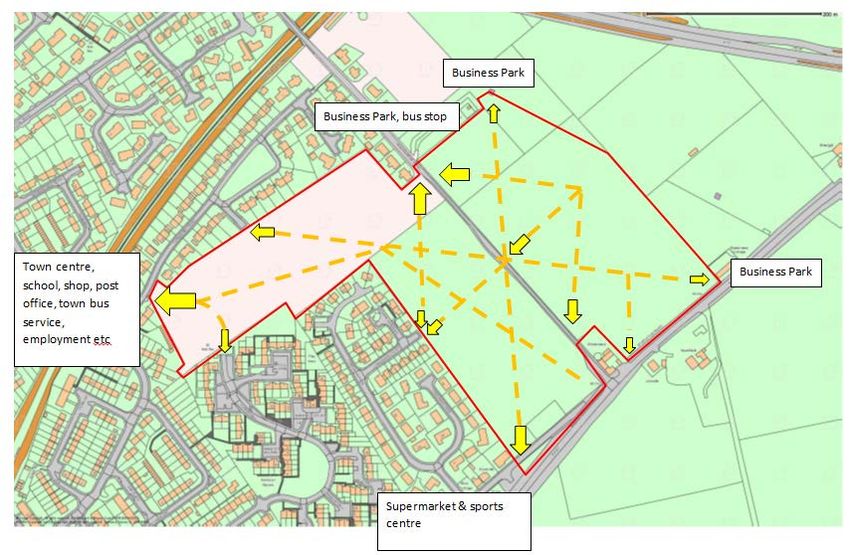
3.3 The business park which is currently being developed to the north east of the
site will accommodate a range of business industrial uses within Classes 4, 5 and 6
of the Town and Country Planning (Use Classes) (Scotland) Order 1997. The plots
located to the south of the service road of the business park, which lie closest to the
Masterplan area, are restricted to uses within Class 4 to minimise the potential
impact on residential amenity. All of the above are indicated in the context map
below at Figure 1. The site which is the subject of the Masterplan is outlined in red.
Figure 1
Employment
Education
Retail
Open space
Sport and leisure
Transport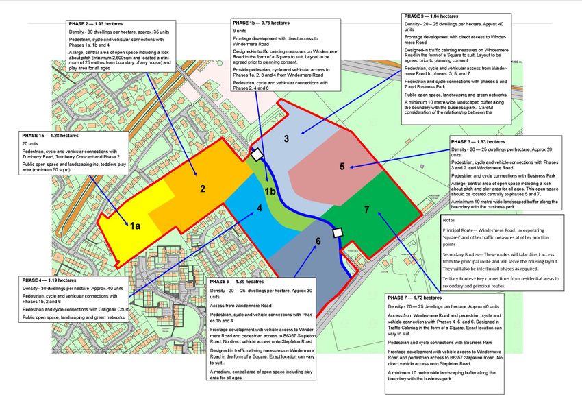
3.4     The site is well connected in terms of vehicular access to key transport routes.
The B6357 Stapleton Road, directly to the south of the site, provides access to the
A75 allowing onward travel to towns and villages in the rest of Dumfries and
Galloway as well as the M74 motorway, Central Scotland, the Borders and England.
The B6357 Stapleton Road is a key route into Annan and, therefore, it is recognised
that this site frontage is of great importance for the development and the town of
Annan.

Site location and description
3.5    The site which is subject of this Masterplan (see Figure 1) is an 11.8ha
greenfield site located approximately 1.2km from Annan town centre, on the north
eastern edge of the town.

3.6    It is situated immediately adjacent to existing residential areas and the new
business and industrial park. Windermere Road, which has been upgraded to serve
the development, runs through the site in a north west – south east direction; and the
B6357 Stapleton Road, which provides the main route into Annan from the north and
east, runs along the south eastern boundary.

3.7    The site was formerly used as agricultural grazing land but is no longer in
active use although the field formation is still evident with intermittent hedgerows,
bushes and small trees traversing and bounding the site, together with a small
number of established and prominent trees across the site. The north end of the site
is elevated with a crown towards the centre; it then slopes steadily southwards
towards the B6357 Stapleton Road, a distance of some 400 metres, see Figure 2
below.

Figure 2
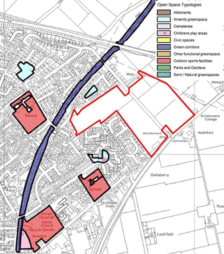
3.8   There is no statutory landscape or other designations affecting the site or
immediate locality. The site is, however, locally notable in that it forms the high
ground in the general area.

3.9   There is significant under provision of open space of any sort, and quality
open space in particular, in the north of Annan, see figure 3. This is a result of the
piecemeal nature of much of the development in this area to date. Through the
development of the Masterplan area it is proposed to enhance the level and quality
of open space provision in the north of Annan.

Figure 3
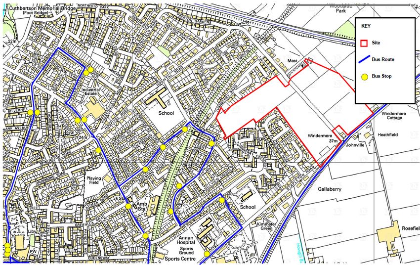
3.10 Current desire lines and connections are shown in Figure 4. There are
currently no cycle paths in the immediate vicinity of the site at the moment.

Figure 4

3.11 The existing residential areas in the locality are well served by public
transport, see Figure 5. The frequent town service has stops on Winterhope Road
and Springbells Road which are within approximately 150-200 metres from the north
west corner of the Masterplan area. The rural / Langholm bus service travels along
the B6357 Stapleton Road which bounds the south of the site.

Figure 5
3.12 There is capacity at both the waste water and water treatment works to
service the proposed development. However, there are localised network constraints
that the developer will need to resolve. Overhead power lines form part of the north
eastern boundary with a pylon sited on this boundary, see Figure 2. The catchment
nursery and primary schools are running at more than 80% capacity

4 Site Opportunities and Constraints

       Opportunities
   •   There is an opportunity to create distinctiveness and a sense of place
   •   The site, along with the adjacent business estate will form a gateway to
       Annan from the north and east
   •   The site lies close to existing and expanding employment areas
   •   The development presents opportunities to enhance both the walking and
       cycle path networks
   •   The development presents opportunities to enhance the greenspace network
       and to link the site with Annan and the wider countryside
   •   There are public transport links in close proximity to the site
   •   The local road network has been upgraded, including Windermere Road
       which crosses the site
   •   The existing landscape features provide an opportunity to include more
       mature landscaping within the overall open space and landscaping plan for
       the site.

       Constraints
   •   Electricity pylons and overhead power lines and associated wayleave run
       along the northern most edge between the site and the business park which is
       currently under construction. There is a pylon located directly on the site
       boundary
   •   There may be some noise from the business park and mitigation measures in
       the form of a bund are required as part of this Masterplan in phases 4, 5 and 7
   •   The catchment primary schools and nurseries are all at or above 80%
       capacity
5 Relevant Policies and Guidance
National policy and guidance
5.1 In preparing the Masterplan there has been regard for the following national
policy and guidance:
• Scottish Planning Policy (SPP)
• Designing Streets
• Designing Places
• Creating Places
• Planning Advice Notes (PANs)
- PAN 61 Planning and Sustainable Urban Drainage Systems
- PAN 65 Planning and Open Space
- PAN 67 Housing Quality
- PAN 77 Designing Safer Places
- PAN 78 Inclusive Design
- PAN 79 Water and Drainage
- PAN 83 Masterplanning
Local policy and guidance
5.2 The Masterplan site is allocated in the Local Development Plan 2 for housing
(sites ANN.H1 and H2). The sites have a combined allocation of 205 units. The site
ANN.H3 Land between Turnberry Road and Turnberry Crescent (20 units) included
in LDP1 was completed in 2017. A requirement of the site guidance is that a
Masterplan is prepared and approved for the site.
5.3 Development proposals will be assessed against the current development
plan and associated supplementary guidance.
5.4 The first version of the Masterplan was adopted in December 2014 in the
context of Local Development Plan 1 adopted September 2014. This version
updates the Masterplan following the adoption of the Local Development Plan 2 in
September 2019. It is likely the site will be developed in phases over the next 10-15
years, or possibly longer.6 Development Principles
6.1 Land use
6.1.1 The aim of the development is to support and help sustain existing services,
facilities and assets in the immediate locality and wider settlement. Together with the
allocation of the land in the LDP2 for housing (H1 & H2), the site will, therefore, be
predominantly residential although some limited, small scale business use could also
be accommodated, including small scale retail, office, café / restaurant, community
hub, children’s nursery etc.
6.1.2 Uses other than residential will be the subject of further discussions with the
planning authority, and will require to be justified in relation to the following:
• Suitability and availability of alternative sites allocated in the development plan for
business use;
• The need for the proposal at that location;
• Impact on vitality and viability of the town centre;
• Impact on the environment and landscape;
• Impact on the amenity of the area;
• Traffic impact;
• Servicing; and,
• Compatibility with other relevant development plan policies
6.2 Development form
6.2.1 The aim is to create a pleasant and welcoming residential environment.
Working with existing ground levels and landscape features will support the creation
of a distinctive and varied development with a positive sense of place. The
development will take the form of a permeable network of connected streets, lanes,
courtyards, squares and open spaces.
6.3 Housing mix and house types
6.3.1 In order to achieve a well-balanced, mixed and sustainable community and
cater for the increasing number and variety of households the development will offer
a range of house types, sizes and densities together with an appropriate mix of
tenures specific to the local need throughout the Masterplan area. The development
will include a mixture of single and two storey, detached, semi-detached and
terraced houses. It is important that the house types are carefully considered to
ensure they are adaptable to the changing needs of their occupants.
6.3.2 The mix of high quality housing will meet the requirements of young couples
and first time buyers, as well as families and the elderly who will all have specific
needs in terms of accessibility and affordability. Evidence suggests that over the
next decade the number of family households in will decrease while the over 75 age
group households will increase. It has been identified that much of the existing
housing stock is of an unsuitable size for the decreasing household sizes.6.4 Density 6.4.1 In order to achieve the housing allocation of 205 units the site will need to be developed at an average density of 30 dwellings per hectare. This density will vary throughout the various phases of the development to reflect the different houses types being built and to reflect the density of the surrounding developments. The phasing plan shown in Figure 7 provides more detail. 6.4.2 Given the nature of surrounding development and a demand for market housing at the more affordable end of the market it is proposed to build smaller house types in phases 2 and 3 i.e. single and two storey, semi-detached and terraced, 1, 2 and 3 bedroom houses. In these areas the density would be approximately 30 dwellings per hectare. This element of the development will not only meet the local need for more affordable housing but also the needs of the areas ageing population and smaller households. 6.4.3 As development progresses in a south and easterly direction towards the B6357 Stapleton Road the density will start to decrease and a range of detached and larger dwellings will be introduced to the housing mix to maintain variety of character, scale and distinctiveness and provide a good range of choice. In phases 4, 5 6 and 7 the density would typically be 20 - 25 dwellings per hectare. 6.5 Site frontages 6.5.1 In recognition of its importance to the development and Annan as a whole, the area of land to the south of the Masterplan area which fronts onto the B6357 Stapleton Road will be developed for housing, open space and landscaping to serve as an attractive and welcoming entrance to the development and the town of Annan. Properties should front onto Stapleton Road, should have pedestrian but not vehicular access to it and should be of a double frontage design. 6.5.2 Phases 1b, 3, 6 and 7 have sections that front on to Windermere Road. These properties which are largely complete, should front onto Windermere Road and take vehicular access directly to Windermere Road. 6.6 Energy efficiency 6.6.1 In addition to the development being designed to encourage active and sustainable travel and reduce car dependence, renewable sources for the production of heat and electricity will be considered at a domestic level. 6.6.2 All houses will be designed and constructed to the highest standards in terms of thermal efficiency and air leakage compliance, in excess of the current building standards requirements and will make use of, and incorporate wherever practicable the latest solar photovoltaic technologies. 6.6.3 The south east facing slope of the site is beneficial in terms of enabling the use of passive solar gain. Buildings will be designed and roofs orientated to maximise passive solar gain and solar technologies.
6.7     Affordable housing
6.7.1     Affordable housing will be provided at a rate of 20% in accordance with
LDP2 and Dumfries and Galloway Local Housing Strategy. LDP1 and the first
version of the Masterplan (December 2014) allocated sites for 230 units and on this
basis the affordable housing requirement was 46 units. The site ANN.H3 Land
between Turnberry Road and Turnberry Crescent (20 units) included in LDP1 was
completed in 2017 for 20 affordable units by Loreburn Housing Association. This
represents 8.7% of the total number of units allocated over the Masterplan area (230
units) resulting in a remaining requirement of some 26 affordable housing units.

6.7.2 The affordable housing will:

•   Meet the local need, as defined in the Local Housing Strategy and Housing
    Needs and Demand Assessment,
•   Meet the terms of the Council’s Local Development Plan,
•   Be delivered through a range of housing types, tenures and sizes,
•   Be distributed throughout the Masterplan area,
•   Be developed simultaneously with each phase,
•   Be indistinguishable from market housing in terms of type, design, quality,
    materials and detail, and
•   Be of high quality and well designed.

6.7.3     The affordable housing component of the development has been delivered
as 20 social rented units in Phase 1a of the Masterplan in the north west of the site,
with the remaining affordable housing requirement provided throughout the rest of
the Masterplan area by the developer. The social rented accommodation would be
delivered and managed by a Registered Social Landlord for which there is provision
for in the Council's Strategic Housing Investment Plan (SHIP).

6.7.4    The remaining 11.3% or 26 affordable units will, therefore, require to be
provided by the developer. Given the desire to create a mixed community, the
remaining affordable housing requirement will be distributed throughout the
Masterplan area at a rate of 11% per phase. The 60 affordable housing units which
form part of Phase 2 by Cunninghame Housing Association will result in the
affordable housing requirement being meet for the entirety of the site.

6.8    Access
6.8.1 The Masterplan area will be a well-connected, inclusive environment enabling
ease of movement for all. All development proposals will meet the aims of Designing
Streets. Design led solutions will consider place before movement and people before
vehicles. There will be a commitment to creating a positive sense of place that is
supported by an appropriate movement pattern. The neighbourhood will be designed
to encourage walking and cycling as well as accommodating vehicular movement.

6.8.2 The site offers good potential for pedestrian, cycle and vehicular links with the
adjoining areas. In accordance with Designing Streets and the LDP, links with
Windermere Road, Turnberry Road, Craignair Court, Turnberry Crescent and
Stapleton Road as well as the new Annan Business Park and the old railway line
path will be maximised with priority given to pedestrians/cyclists.
Pedestrians and cyclists 6.8.3 The development will be designed with the pedestrian and cyclist in mind. It will be a permeable, walkable neighbourhood. Walking and cycling routes will be determined by clear desire lines and will connect to established pedestrian, cycle and public transport providing greater access for all to adjoining neighbourhood services, the town centre, the new business park and the countryside and encouraging active travel. 6.8.4 A combination of straight, direct streets which aid navigation and enhance personal security will encourage walking; and irregular streets will contribute to visual variety and diversity making for a pleasant walking or cycling experience. All routes will well lit, directly overlooked and designed to promote high standards of safety and security. Public transport 6.8.5 The proposed development has been designed to integrate with existing public transport routes. Windermere Road has been designed as a bus route as have the primary streets in order that they could be used as future bus routes. All homes will be located within 400 metres (5 minute walk) of a bus stop to ensure good access to public transport for all residents. The focus on public transport and active travel networks will discourage car dependence. 6.9 Roads Infrastructure Transport Assessment 6.9.1 A Transport Assessment has been carried out to determine the cumulative impact of the whole development on the local road and trunk road networks. This found that the increase in traffic as a result of the development can be accommodated within the existing road network, subject to the upgrading of Windermere Road, without a need for improvement of local junctions. Hierarchy of Streets 6.9.2 The uprading of Windermere Road which is key to unlocking the development potential of this site was completed in 2014. 6.9.3 As the design and construction of the upgraded stretch of Windermere Road pre-dated this Masterplan, it was not possible for the new road alone to fully accord with the aims and objectives of Designing Streets. The road (carriageway only) was designed with horizontal deflection which combined with the future development of the adjoining land and points of access into the development, will naturally encourage drivers to travel more slowly by reducing forward visibility and increase compliance with Designing Streets.
6.9.4 The location and form of the points of access into the development from
Windermere Road will be determined in consultation with the planning and roads
authorities and designed in accordance with Designing Streets, the phasing plan at
figure 7 shows indicative locations. It is recognised that the junction location and
design are paramount to prevent prejudicing development of the Masterplan area.
Features designed to encourage slower vehicle speeds shall be designed to
minimise the need to dig up the new carriageway.

6.9.5 The street hierarchy within the development will evolve as a result of
connections with existing development and street networks together with the
topography and shape of the site.

Principal route – Windermere Road is the main route through the area.

Secondary routes - These routes will take direct access from Windermere Road at
specific locations to suit the housing layout. Traffic calming measures will be
required at all junction points.

Tertiary routes - These routes form key connections from residential areas to
secondary and principal routes. They provide safe travel to important destinations
around the community. Traffic calming measures will be required at all junctions.

6.9.6 The site will be developed with streets and houses located / positioned and
orientated using existing ground levels to minimise the level of cut and fill, need for
retaining structures and impact on residential amenity. Use of the existing
topography and landscape features will enhance the sense of distinctiveness
throughout the development. Construction materials should reflect the character of
the surrounding area.

6.9.7 Streets will be designed to encourage social interaction and the creation of a
sense of community. The arrangement and orientation of the dwellings is crucial.
Dwellings will front on to Windermere Road and be situated in the front half of the
plot so as to increase the feeling of enclosure and together with junction design and
landscaped features, including street trees, will naturally encourage drivers using this
route to travel more slowly and create a positive sense of place. There will be a
strong emphasis on shared access and shared spaces in line with Designing Streets.

Traffic speed
6.9.8 Within the development streets will be designed to influence driver behaviour
to reduce vehicle speed to levels that are appropriate for the local context and
deliver a safe environment for all. Designed in traffic calming measures will include
shared pedestrian, cycle and vehicle routes, street dimensions (i.e. short lengths of
street, reduced carriageway width and radii at corners and junctions), reductions in
forward visibility, changes in priority or no priority at junctions, physical features
involving horizontal deflection and materials. Such natural traffic-calming features will
be built into the layout of the streets at intervals of around 60-80m in order to achieve
speeds of 20 mph or less and there will be minimal use of traffic signs, road
markings and other traffic management features
Parking
6.9.9 The development will be designed to accommodate parking without
compromising the positive sense of place. Parking will be designed so as not to
dominate the streetscene and will predominantly be located behind the building line.
Parking in front garden areas will be avoided.

6.9.10 To deliver a successful development where functionality is
accommodated within a high quality residential environment requires a
multidisciplinary collaborative approach. As a result applications for Road
Construction Consent will be progressed in parallel with all future planning
applications.

Emergency and service vehicles
6.9.11 Swept-path analysis will be used to demonstrate that streets are capable
of accommodating large vehicles.

Utilities
6.9.12 The accommodation of services will not determine the layout of streets or
footways but will be considered at an early stage. Utilities such as gas, electricity,
water and telecommunications will be located within service strips / corridors. The
layout of servicing routes should not prejudice the layout of future phases of the
development

Lighting
6.9.13 Street lighting will be:
   • Designed as an integral part of the street design;
   • Appropriate and sympathetic to the context;
   • Discrete.

Street Furniture/Signage
6.9.14 The use and placement of street furniture will:
   • Be kept to a minimum;
   • Be robust, high quality and durable;
   • Reflect the direction of pedestrian movement to ensure clear unimpeded
       routes;
   • Seating will be orientated towards areas of open space;
   • Signage will be fixed to existing poles and will be kept to a minimum, only
       being used when required.

6.10 Open Space
6.10.1 Supplementary Guidance on Open Space and New Development sets out the
requirements for provision of open space under the terms of LDP2 policy CF3: Open
Space. The advice takes account of and is informed by data and objectives from the Open Space Audit and Open Space Strategy. 6.10.2 Open space makes an important contribution to the quality of residential areas. The aim is to provide all residents with access to a network of linked, high quality and safe, formal and informal, active and passive open spaces within the development which will be valued by the community. The open spaces will enhance the sense of place, distinctiveness and amenity, encourage physical activity, contribute to nature conservation, biodiversity and recreation as well as aiding navigation and orientation. 6.10.3 The open space, green network and landscaping strategy has been approached from a development wide perspective and looks at all phases together. 6.10.4 The Open Space Strategy sets out an ideal quantity standard for open space in a settlement and an accessibility standard for open space which sets out the distance from a reasonably sized functional piece of open space that every household is expected to be within walking distance of. Every household should be within a five minute walk of publicly usable open space of at least 0.2 hectares. 6.10.5 According to the Open Space Audit, for the size of the population, Annan overall has been identified as having a deficit of publicly usable open space. However, the settlement as a whole does currently have a good provision of parks and gardens with one of the largest parks in the region at Everholm Park and also a large number of play areas. 6.10.6 In the specific Windermere Road area, there is a limited amount of publicly usable open space (much of the other open space in this area comprises of school playing fields which is unlikely to be available to the general public). Access to the proposed green corridor walking route which is formed by the former Chapelcross pipeline should be considered as part of the development. A children’s play area has been created in the Turnberry Crescent development (ANN.H3). 6.10.7 In relation to overall accessibility, the western part of the overall site does have access to the small areas of existing open space but the eastern area (in particular part of phase 3 and all of phases 5 and 7) would not currently meet the accessibility target. Figure 6 below shows the accessibility buffers (shown in green) from publicly usable space of 0.2 hectares and above in this part of Annan. Due to the deficit of overall space, the lack of accessibility to existing space and the large scale of the site, there will need to be ample on-site provision of open space.
Figure 6

Quantity
6.10.8 The open space provision should be based on the whole site capacity and not
on the number of houses within each individual phase. The Open Space Strategy
and the related Supplementary Guidance on Open Space and New Development
states that, for new development, in an area that currently has less publicly usable
open space than the quantity standard, then the developer will be required to provide
good quality open space within the development equivalent to the quantity standard,
whilst also meeting the accessibility target. The target can be calculated once the
quantity standard has been agreed. Initially, this figure could be calculated using the
current average household size for Dumfries and Galloway which is 2.14 people per
household. The final figure would depend on the estimated household sizes for this
development, which will be affected by the house types that are built.

Accessibility
As demonstrated above, large parts of the site would not be within a five minute walk
of an existing piece of open space. The accessibility analysis set out in the Open
Space Strategy has initially been based on an “as the crow flies” buffer but more
detailed analysis will need to be undertaken by the developer to determine the full
extent of accessibility. This will need to take into account barriers such as main
roads or watercourses and the actual route that would need to be taken to access
existing spaces. For example, although an open space may appear to be close to
the development site, pedestrian access may be via a fairly long and indirect route.
This appears to be the case with the open space located to the west of the site within
the Turnberry Crescent area.

Open space will need to be distributed throughout the development to ensure
appropriate accessibility for every resident. Given the size of the development
several play areas will be required throughout the development. Phases 2, 5, 6 and
7 in particular will require sufficient areas of open space to ensure accessibility.

In addition to the above requirements for all areas of open space, play areas will:

   •   Be centrally located within the development;
   •   Be distant from busy road junctions;
   •   Where equipped, be equipped with good quality play equipment in
       accordance with BSEN1176 and BSEN1177 and safer surfacing;
   •   Include a buffer zone between it and adjacent dwellings

Open space within the development will be delivered in the following way:

General principles

   •   The type and amount of open space will be determined in consultation with
       local officers and the current identified needs of the settlement but it is likely
       that the development will need to meet the quantity standard as set out in the
       Open Space Strategy and related Supplementary Guidance on Open Space
       and New Development and will require a mix of multi-functional, well-
       connected spaces, including amenity space, play areas, sports provision,
       natural and semi-natural spaces and possibly allotment provision; the
       developer may also wish to explore how open space can be delivered in an
       alternative way which could reduce the overall requirement on the site - this
       could include, for example, exploring whether existing nearby open space
       which is currently not publicly usable could be made available for the public or
       considering the creation of multi-functional SuDS features which also provide
       amenity space;
   •   All residents should be within a five minute walk of open space of at least 0.2
       hectares but ideally of larger areas; this would equate to approximately 400
       metres and be identified through a network analysis using actual routes and
       taking account of potential barriers to access;
   •   Open spaces should be designed to try to ensure a network of spaces which
       may connect with paths or green corridors;
   •   The provision of a few larger, high quality areas of open space, in
       predetermined phases of the development can be used to offset the open
       space requirement for the subsequent phases of the development.
   •   If a large amount of open space is to be provided in an early phase or phases
       of the development, with the intention of ‘banking’ this open space against the
       subsequent phases, this requires to be agreed and incorporated into the
       unilateral Section 75 planning obligation.
   •   Any banking proposal not provided for in the initial Section 75 will require the
       satisfactory completion of a further legal agreement at the time that the
       planning application, including the overprovision, is determined.
Specific open space requirements for each phase is set out in Figure 7. 6.11 Landscaping 6.11.1 Open space in the form of landscaping will aid integration with the landscape, enhance the quality and amenity of the development helping to create an attractive environment in which to live as well as encourage biodiversity. The landscaping strategy includes the retention and enhancement of existing landscape features together with the provision of new landscaping. 6.11.2 Landscaping proposals will incorporate existing trees and hedgerows throughout the site as it is recognised that these established trees, bushes and hedgerows will enhance the setting of the new development. 6.11.3 The former field boundary hedgerows, bushes and small trees together with the 2 prominent trees within the hedgerow linking Windermere Road and the north end of Craignair Park will be retained and incorporated within the new development. 6.11.4 Areas of new planting will be of species native to the area and appropriate for the scale of development. Creating planted areas with native species will ensure that maximum potential is realised offering the opportunity to enhance amenity, create valuable wildlife habitat and to provide links to the wider area and the countryside. Specimen / feature trees will be used to create landmarks and visual stops to vistas which will have amenity value and aid navigation and orientation. 6.11.5 Natural and hard landscaping will be a feature of streets, lanes, courtyards and squares throughout the development. They will provide visual amenity as well as serving to protect residential amenity by providing light /soft screening to frontages / properties. 6.11.6 A minimum 10 metre wide landscaped buffer of native trees and bushes will be created along the north east boundary of the Masterplan area, between the proposed residential development and adjoining business park, to minimise noise and preserve residential and visual amenity. This planting strip will be carefully considered to ensure effectiveness and compliance with the statutory wayleave / safety clearance required for the pylons and overhead power lines. This landscaping buffer does not contribute towards the open space provision within the Masterplan area. Management and maintenance 6.11.7 All areas of public open space and landscaping will be designed and formed to the standards required for adoption by the local authority. A scheme for the future maintenance of all areas of open space and landscaping will be submitted together with all future planning applications which include open space and landscaping. 6.11.8 Should the Council agree to adopt these areas they will be transferred to the Council together with payment of a commuted sum, based on an agreed amount of annual maintenance costs as set out in the Supplementary Guidance on Open Space and New Development to finance future maintenance. Issue
6.11.9 In the event that the Council declines to accept responsibility for the future
maintenance of any open space in this development, the area or areas of open
space and landscaping will be privately maintained in perpetuity to the satisfaction of
the planning authority through, for example, a factoring agreement. A legal
agreement will be required to secure the future management and maintenance of all
areas of open space and landscaping within the Masterplan area unless/until
adopted. Management and maintenance can be transferred to an entity other than
the developer by means of a Deed of Conditions which shall be approved by
Dumfries and Galloway Council.

6.12   Servicing

Sustainable Drainage Systems (SuDs)
6.12.1 A detailed Drainage Impact Assessment and a Surface Water Drainage
Strategy for the whole site has now been agreed with SEPA, Scottish Water and
Dumfries and Galloway Council. While the development will be progressed in a
phased manner, the surface water drainage strategy has been developed for the
development as a whole.

6.12.2 Together, these documents will help to inform the detailed surface water
drainage solutions for the whole development. A unified approach to surface water
drainage from on-site roads and the remainder of the site will be required.

6.12.3 In determining a surface water drainage strategy for the Masterplan area, the
recommendations must:

   •   Include surface water drainage as an integral part of the development;
   •   Ensure the proposals contribute to amenity and place-making;
   •   Integrate, where possible, SuDS into public open space provision;
   •   Deal with surface water run-off close to source control;
   •   Manage water quantity and quality using sustainable urban drainage systems
       in accordance with the CIRIA SuDS Design Manual C697;
   •   Install at least two levels of SuDS treatment to achieve the required water
       quality for surface water run off;
   •   Improve the current biodiversity and amenity of the area;
   •   Minimise the environmental impact of the proposed development;
   •   Incorporate public health and safety;
   •   Include long term maintenance and management arrangements

6.12.4 SuDS are not simply a technical requirement and emerging guidelines and
good practice actively encourage the locating of SuDS within areas of open space.
The surface water drainage proposals will need to form an integral part of the
development and, in particular, the public open space provision. SuDs and open
space will serve as integrating and connecting features and will not be isolated,
standalone features.

6.12.5 When SuDS are integrated into public open space it can provide an excellent
opportunity for recreational enjoyment, to enhance the amenity value of open space,
encourage local wildlife as well as have a positive impact on house values by
creating a high quality residential environment. Consequently, the good sized areas
of open space within this development will be further enhanced through the
intelligent design and location of SuDS.
6.12.6 Located centrally where there is natural surveillance, by way of properties
facing onto the SUDs and open space, results in increased safety and reduces the
potential for anti-social behaviour and fly-tipping.
6.12.7 While the south end of the Masterplan area is the lowest point of the site the
importance of the B6357 frontage is recognised and, consequently, it is not
appropriate or desirable to locate a SuDS feature in this area.
All SuDS proposals will:
• Be designed as an integral part of this future community to maximise the
benefit to the residential area;
• Be designed to have a natural form and appearance to complement areas of
open space and integrate into the landscape;
• Be directly overlooked by the living areas of adjacent dwellings to ensure
good passive surveillance, help to foster a feeling of safety and discourage
anti-social behaviour;
• Not be located to the rear of dwellings;
• Be developed simultaneously with each phase of development;
• Be covered by an appropriate management and maintenance regime.
Foul drainage and water supply
6.12.8 There is currently sufficient capacity at Annan Waste Water and Water
Treatment Works to serve the whole development. However, there are localised
sewer network infrastructure constraints, the developer has agreed a solution with
Scottish Water. Future upgrades may also be required on the water network to
accommodate new development.
7 Developer Contributions
7.1 Within the development plan where a development proposal creates a need for
new, extended or improved infrastructure, community facilities and / or
environmental amenity developer contributions will be sought. Developer
contribution requirements need to be proportionate and reasonable, based on
evidence and take into account the financial viability of developing the site. The
Developer Contributions Supplementary Guidance provides further detail.
7.2 If the provision of developer contributions makes the development unviable the
developer will be required to provide a full development appraisal demonstrating the
negative impact the contribution has on the development. Where it is considered that
the burden imposed by the contribution is so great that the development would not
otherwise take place the Council will negotiate with the developer. Negotiations will
assess benefits the development brings to the community and determine if mitigation
can be met through other means.Education
7.3 The Council’s Education Service has confirmed that there is limited capacity
within Newington primary school which is the catchment primary school for the
Masterplan site. The development of the Masterplan site will place additional burden
on existing provision.
7.4 On average housing developments generate approximately 0.8 nursery
school, 0.32 primary school and 0.14 secondary school pupils per dwelling. This will
be a substantial financial burden on the Education Service in the provision of
additional spaces and will also add an additional burden to the limited
accommodation presently provided within the existing nursery and primary school.
Given that Newington primary and nursery schools have limited capacity and a need
for additional school places will be a direct consequence of the development a
contribution towards the additional costs of education provision will be required.
7.5 The additional pupils will result in the requirement for an extension to the
nursery and primary school building. This will include additional classrooms, toilet
facilities and associated circulation space to the current building. The Developer
Contributions Likelihood Table, which is an attachment to the Supplementary
Guidance, sets out the anticipated financial contribution requirements per housing
unit. As stated in the Likelihood Table, proposals will result in a consultation with
Education Services to confirm the financial requirement. There are 2 options
available to the developer in meeting this contribution requirement. The first option
(Council preferred option) is for the developer to pay an amount to be agreed with
the Council. The amount will be paid in instalments which will be required to be paid
within each phase of the development in proportion to the number of dwelling houses
within that phase. The contribution will be required from phase 2 onwards. The other
option is to enter into negotiations with the Council to build the required works to the
Council’s specification as an alternative to making the financial contribution. The
contribution will be secured through a Section 75 planning obligation which will be
consistent with the tests set out in Circular 3/2012.
8 Phasing plan
The phasing plan as at December 2014 (see Figure 7) ensures the Masterplan area
is developed in a logical, sequential manner; key infrastructure, open space and
affordable housing are delivered in accordance with the development plan and
development of no part of the Masterplan area is prejudiced. The following section
updates progress on the phasing as at August 2019.
All phases will be required to include the following as standard:-
• Surface water and foul drainage;
• Designed in accordance with Designing Streets principles;
• Open space in accordance with the Open Space and New Development
Supplementary Guidance;
• Retention and enhancement of existing boundary hedgerows (except for
phase 1b);
• Affordable housing in phases 1a, 2, 3, 4, 5 and 6.
Phase 1 of the development will be split between 2 distinct areas of the site.Phase 1a – 20 units completed in 2017 for affordable housing units by Loreburn Housing Association. These affordable housing units will be banked against later phases of the development. Phase 1b - To minimise initial infrastructure costs and offset the sale of land at below open market value to the Registered Social Landlord, it is proposed to construct nine dwellings fronting onto Windermere Road. This phase was completed in 2018. Phase 2 - In order to link the two parts of the development to be provided in Phase 1 and create connectivity and a sense of place in the short term and prevent isolated development and car dependence, development of the Masterplan area will then proceed with the area in the north of the site. Construction has now commenced on Phase 2A. Planning consent 18/1301/FUL for 22 affordable houses and associated infrastructure was granted on 28 February 2019. Site works commenced in June 2019 and completion is programmed for March 2020 by Cunninghame Housing Association. Planning consent 19/0629/FUL for 38 dwelling houses, access roads and associated works was granted on 23 August 2019. Works are programmed to commence in 2020/21 with completion due by March 2021 by Cunninghame Housing Association. These 60 affordable housing units will result in the affordable housing requirement being meet. Phase 3 – Development will then continue to the east of Windermere Road. Development of land on both sides of Windermere Road will assist in naturally influencing driver behaviour and vehicle speeds. Dwelling units were completed fronting Windermere Road in 2019. Phase 4 - Development will then continue from phase 2 in a south and easterly direction. Phase 5 - Development will then continue to the east of Windermere Road in a south and easterly direction. Phase 6 - Development will be completed to the south west of Windermere Road by extending to the boundary with the B6357 Stapleton Road. Phase 7 - Development will be completed to the north east of Windermere Road by extending to the boundary with the B6357 Stapleton Road. Placemaking In order to demonstrate compliance with national and local policy on placemaking the planning application for each individual phase shall be accompanied by a statement which sets out how the development meet the aims and objectives of the current policy. The submission shall include a design statement and a B-Plan.
9     Section 75 Planning Obligation
9.1   A Section 75 Planning Obligation is unilaterally proposed by Anderson Joinery
together with this Masterplan to bind the title for the whole Masterplan area and
secure the required provision of affordable housing; open space, landscape and
SuDS maintenance, and the developer contribution in respect of education.

9.2   The Masterplan and unilateral obligation together will allow the site to be
developed in phases, which will be subject of individual planning applications, and
ensure the development, as a whole, accords with local and national policy.

10     Status of Masterplan
10.1 The Masterplan was adopted as supplementary guidance to LDP1 and it
became part of the development plan for the purposes of assessing planning
applications. It was initially adopted in December 2014 and has now been updated
following the adoption of the Local Development Plan 2 in September 2019.

10.2 Development proposals that are not in accordance with the Masterplan will
need to be supported by evidence and a reasoned planning justification as to why
the Masterplan should be departed from.
You can also read