Bray and Environs Transport Study - April 2019 - National Transport Authority
←
→
Page content transcription
If your browser does not render page correctly, please read the page content below
2019 Bray and Environs Transport Study
        NTA TII WCC DLRCC

Bray and Environs
Transport Study

April 2019

National Transport Authority
Wicklow County Council
Dún Laoghaire-Rathdown County Council
Transport Infrastructure Ireland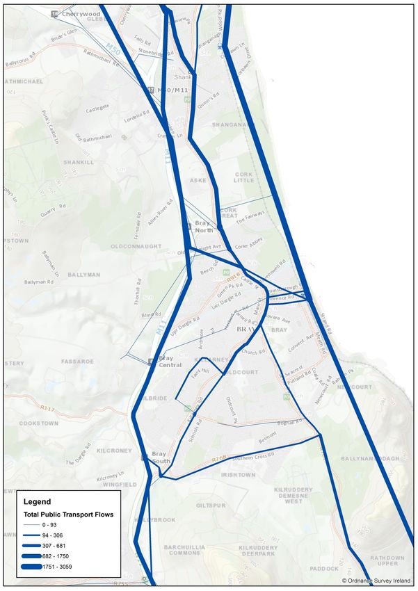
2019 Bray and Environs Transport Study                        NTA TII WCC DLRCC

1 Introduction                                                                    2
   1.1    Background                                                               2
   1.2    Objectives and Key Stages                                                2
   1.3    Report Structure                                                         2

2 Preferred Approach                                                              3
   2.1    Public Transport, Walking and Cycling                                    3
   2.2    Road                                                                     4
   2.3    Local Details                                                            7

3 Implementation                                                                  9
  3.1 Introduction                                                                 9
  3.2 First Growth Area – Phase 1 (a) Fassaroe                                     9
  3.3 Further Phases of Fassaroe                                                  11
  3.4 Bray and Environs Development Phase A – 2019-2027                           11
  3.5 Bray and Environs Development Phase B – 2028-2035                           11
  3.6 Current Public Transport Programme                                          12
  3.7 Bray Municipal District Local Area Plan 2018                                12
  3.8 Recommendations for Dún Laoghaire-Rathdown County Council                   13
  3.9 Next Steps                                                                  13

2019 Bray and Environs Transport Study NTA TII WCC DLRCC
1 Introduction
1.1 Background
Following a meeting held in 2017, the National Transport Authority (NTA), Transport Infrastructure
Ireland (TII) and Wicklow County Council (WCC) agreed to undertake a transport study for Bray
and Environs. The overarching purpose in undertaking this study was to seek to facilitate the land
use objectives of Wicklow County Council and Dún Laoghaire-Rathdown County Council as
provided for in statutory regional, county and local plans.
The approach taken was to set out the local interpretation of the NTA’s Transport Strategy for the
Greater Dublin Area and DPHLG’s Spatial Planning and National Roads Guidelines for Planning
Authorities, and to express, in an integrated manner, the transportation policies and objectives of
Wicklow County Council and Dún Laoghaire Rathdown County Council, as contained in their
County Development Plans and local area plans. The latter were at various stages in their
development as this study was being prepared. The study also incorporates the outcome of the
assessment of the recommendations from TII’s M11/N11 Corridor Study Needs Assessment Report
of 2016 and subsequent related NDP and Part 8 projects.
The statutory processes outlined above are subject to legislative requirements relating to public
consultation and environmental assessment. As such, the preferred approach set out in this Study
does not define rules that must be complied with when administrative consent of projects is being
granted. They are non-binding and advisory and do not comprise public policy.
1.2 Objectives and Key Stages
This study assumes that the NTA Transport Strategy and the TII Corridor Study Needs Assessment
Report form the basis for transport investment in the Study Area up to 2035, both of which are
provided for and supported by the National Development Plan. The first objective of the study is
therefore not to revisit these policy documents, but by way of carrying out further analysis
focussed on the Bray and Environs area, to determine how the measures set out in these
documents could be applied at the local level. The second objective of the study is to set out the
transport implications, in terms of mode share, journey times etc. of the land use patterns
envisaged by the two local authorities for the Study Area.
The following outlines the key stages of this exercise:
Review receiving environment;
Determine the travel demand associated with the existing and proposed land-uses for the
Study Area;
Apply a local interpretation of the public transport, walking, cycling and road proposals
provided for by the NTA Transport Strategy and National Development Plan, with a view
to accommodating demand in the Study Area in a sustainable manner;
Undertake modelling of the emerging option and refine if necessary; and
Recommend an emerging preferred approach to cater for the Study Area.
1.3 Report Structure
The report sets out the preferred approach for the long-term delivery of land use and transport
objectives for Bray and Environs and is intended to inform their implementation, with specific
emphasis on the delivery of development at Fassaroe in the short term. The Appendices set out
the methodology for the study and the manner in which the preferred approach identified by this
Study emerged.
2
2019 Bray and Environs Transport Study NTA TII WCC DLRCC
2 Preferred Approach
2.1 Public Transport, Walking and Cycling
Following the assessment of the options undertaken, the following AM Peak Hour public
transport, walking and cycling measures are deemed necessary for the future development of
the Study Area. These measures are recommended to be subject to on-going monitoring and
review, including their phased introduction in line with development occurring within the Study
Area. They are shown in Figure 2.1.
1. Luas Extension to Bray Town Centre
7.5 minute AM Peak Hour frequency with interchange with Metro at Sandyford.
Luas Stops at Stonebridge Road, Crinken Lane, Allies River Road, Old Connaught
Avenue, Dublin Road, former Bray Golf Club and Bray DART Station.
2. Luas / DART / Bus Interchange at Bray Station
3. Bray Core Bus Corridor Dublin Rd / M11 – N11
3-minute AM Peak Hour frequency from DART station to City; and
10-minute frequency express service from South Bray to CBC via Bus / Bus
Interchange
OR
6-minute frequency from DART and from Bray South forming 3-minute peak hour
spine onto Dublin Road
4. Bray South Feeder Services to DART and CBC
10-minute coordinated frequency bringing 5 minute frequency to Main Street on to
DART station
5. Fassaroe to Bray DART Bus Service
5-minute frequency
6. Fassaroe – Old Connaught – Woodbrook DART Station Bus
10-minute frequency using new Busway and Bridge over County Brook at Ballyman
Glen, via Old Connaught Avenue and an upgraded Wilford Interchange or via a new
Road from Ferndale Road to Dublin Road
7. Feeder Bus from Metro at Sandyford via N11, Cherrywood and Rathmichael to Bray
DART Station via new Cherrywood to Rathmichael link road
8. Woodbrook DART Station and Park and Ride
9. DART 10-minute frequency plus 2 AM Peak Hour service inserts
10. Associated infrastructure
3
2019 Bray and Environs Transport Study NTA TII WCC DLRCC
Public Transport, Pedestrian and Cycle Bridge and link from the Golf Club Lands to
Bray DART Station
Cycle and Pedestrian Bridge over the N11 from Fassaroe
Implementation of the Greater Dublin Area Cycle Network Plan
Priority for Bus on Dublin Road, Castle Street, Lower Dargle Road
Busway from Fassaroe to Old Connaught over County Brook at Ballyman Glen
Improvements to the pedestrian network in the study area
In addition to the above, the potential for a bus-based Park & Ride south of Bray will be
examined. This facility would be designed with a view to serving travel demand from South
Wicklow and Wexford, beyond the study area, and encouraging transfer from car to bus, thereby
reducing demand for travel by private car on the N/M11 in the study area and northwards.
2.2 Road
Following the assessment of the options undertaken, the following roads measures are deemed
necessary for the future development of the Study Area:
1. N11/M11 Junction 4 to 14 Improvement Scheme;
2. Delivery of Wicklow County Council Part 8 N11 capacity and safety upgrades, as
approved;
3. Interim Traffic Management Measures Framework to protect strategic function of the
N/M11 arising from the initial phased development of Fassaroe;
The following additional local roads and traffic management measures may be deemed
necessary for the future development of the Study Area subject to section 5.8.3 of the Transport
Strategy for the Greater Dublin Area – Principles of Road Development, feasibility and
environmental assessment, and demonstration of their compatibility with the strategic function
of the national road network:
New Road Bridge from Herbert Road to Upper Dargle Road
New road link from the M50 Cherrywood Interchange to Rathmichael
Ferndale Road to Dublin Road, Shanganagh link road; and
Traffic Management in Bray Town Centre
4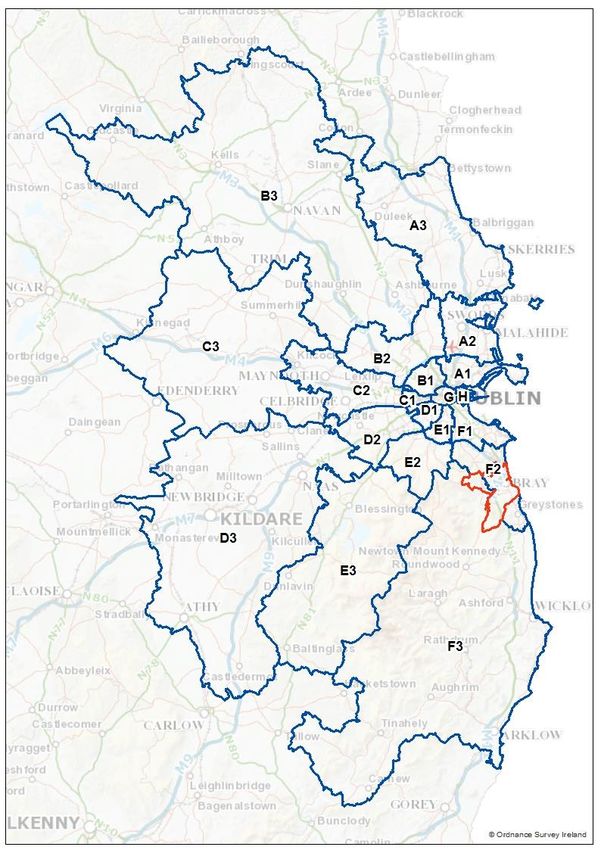
2019 Bray and Environs Transport Study                NTA TII WCC DLRCC

                Figure 2.1: Preferred Approach 2035

                                                                          5
2019 Bray and Environs Transport Study                                 NTA TII WCC DLRCC

ADDENDUM – March 2018
Metrolink
During the final stages in the development of this study, the NTA launched the Emerging Preferred
Route for Metro. Instead of two separate projects as envisaged in the 2016 Transport Strategy –
Metro North and Metro South – it is now intended to deliver Metro as one project from Swords to
Sandyford. This involves the construction of a new line from Swords to the City Centre, tying in
with the existing Luas Green Line at Charlemont, which will be upgraded to deliver Metro levels of
service as far south as Sandyford.
This is a departure from the baseline assumptions used in the development of the transport
options and the derivation of the Preferred Approach in this study. Bride’s Glen was originally
intended to act as a terminus for Metro, and consequently as the hub for interchange from the
Bray Luas and feeder bus services. It also provided for through-running of Luas trams from Bray to
the City Centre, which is not possible under the new proposals. The images and commentary in the
Appendix includes the original Transport Strategy proposal for Metro and Luas.
The most significant implication of the Metrolink for this study is that a higher-frequency Luas
service than that originally envisaged could be provided from Bray to Sandyford, at which point,
however, all passengers would be required to interchange with Metro for onward travel. It also
renders the Bus/Metro interchange at Bride’s Glen redundant. Instead the northern section of the
bus feeder from Bray to Bride’s Glen would be extended under the preferred approach to
Sandyford with some or all services terminating at the Sandyford Bus/Luas/Metro interchange,
and the remainder terminating in Cherrywood, depending on emerging demand patterns.
The NTA have assessed the above scenario and are satisfied that the outputs from the model for
the 2035 scenario do not depart significantly from those set out for the original Preferred
Approach. Metrolink is scheduled to commence operations during Phase 2 of this study. As such, it
has no bearing on servicing immediate growth in Woodbrook / Shanganagh, Fassaroe, Bray Town
Centre, and the former Bray Golf Club lands, which is recommended will be undertaken in line
with the Preferred Approach. The early phases of the development of Old Connaught would be
served by interim bus measures linking to DART and the Dublin Road Bus Corridor, which would be
developed by the NTA in due course, as development plans become clear for this area.

                                                                                                 6
2019 Bray and Environs Transport Study                                     NTA TII WCC DLRCC

2.3        Local Details
2.3.1      Fassaroe
The following is required to serve the full build-out of Fassaroe:
      -   Fassaroe development roads;
      -   N11 Cycle and Pedestrian Bridge;
      -   N11/M11 Junction 4 to 14 Improvement Scheme
      -   Delivery of Wicklow County Council Part 8 N11 capacity and safety upgrades, as approved;
      -   Busway from Fassaroe to Old Connaught over County Brook at Ballyman Glen;
      -   Traffic Management Measures at Fassaroe Interchange to protect strategic function of the
          N/M11; and
      -   Commitment to the phased introduction of bus and enhanced rail services in line with
          increased demand.

At a more detailed level, the development of Fassaroe may commence on a tightly phased basis
when certainty on the need for and delivery of the above is fully determined. Please see sections
3.2 and 3.3.

2.3.2      Bray Golf Club Lands
The following is required to serve the full build-out of Bray Golf Club lands:
      -   Golf Club Lands development roads;
      -   Pedestrian and cycle links from the Golf Club to Bray Town Centre;
      -   Dublin Road bus priority (part of Bray Core Bus Corridor);
      -   Public transport, pedestrian and cycle bridge from the Golf Club Lands to Bray DART
          station for future use by Luas;
      -   Development of interchange at Bray DART Station; and
      -   Commitment to the phased introduction of bus and enhanced rail services in line with
          increased demand.
2.3.3      Woodbrook
The following is required to serve the full build-out of Woodbrook / Shanganagh:
      -   Woodbrook DART Station; and
      -   Commitment to the phased introduction of bus and enhanced rail services in line with
          increased demand.
2.3.4      Old Connaught
The following is required to serve full build out of current residentially zoned lands at Old
Connaught:
      -   Subject to section 5.8.3 of the Transport Strategy for the Greater Dublin Area – Principles
          of Road Development, feasibility and environmental assessments, and demonstration of
          their compatibility with the strategic function of the national road network, securing
          planning consent and funding commitment for upgrades to the road network to facilitate
          the safe, convenient and reliable movement of public transport, cyclists and pedestrians,
          including for the following schemes:
              o Upgrade of Ferndale Road;
              o Development of new road link from Ferndale Road to Dublin Road at Shanganagh;
                  and
              o Cherrywood to Rathmichael link road;

                                                                                                   7
2019 Bray and Environs Transport Study                                    NTA TII WCC DLRCC

    -   Commitment to the phased introduction of bus services in line with increased demand.

At a more detailed level, the development of the residentially zoned lands at Old Conna is subject
to the adoption of a Local Area Plan. As part of the making of this Local Area Plan, it is
recommended that DLRCC, with input from the NTA and TII, will prepare an implementation plan
for these lands. This implementation plan is recommended to include a phasing programme which
would set out the transport infrastructural and service requirements for each successive phase of
development. It is recommended that this implementation plan would be incorporated into the
Local Area Plan.
Any potential longer-term future development at Old Connaught – beyond that envisaged by the
Dun Laoghaire-Rathdown County Development Plan 2016-2022 – would require unambiguous
commitment to the delivery of the Luas Green Line from Bride’s Glen to Bray - a project already
provided for in both the NTA GDA Transport Strategy 2016-2035 and the National Development
Plan 2018-2027.

2.3.5    Rathmichael
The following is required to serve Rathmichael:
    -   Subject to section 5.8.3 of the Transport Strategy for the Greater Dublin Area – Principles
        of Road Development, feasibility and environmental assessments, and demonstration of
        their compatibility with the strategic function of the national road network, securing
        planning consent and funding commitment for upgrades to the road network to facilitate
        the safe, convenient and reliable movement of public transport, cyclists pedestrians,
        including for the following schemes:
            o Upgrade of Ferndale Road;
            o Development of new road link from Ferndale Road to Dublin Road at Shanganagh;
            o Cherrywood to Rathmichael link road;
    -   Commitment to the phased introduction of bus services in line with increased demand.

The delivery of all transport infrastructure and services for the current residentially zoned lands at
Rathmichael is recommended to be undertaken according to a phasing programme for
development to be prepared by DLRCC in collaboration with NTA and TII and are recommended to
be subject to monitoring and review as investment in transport infrastructure in the Study Area is
realised, in particular Woodbrook DART Station and the Luas Green Line extension to Bray . It is
recognised that any significant development at Rathmichael will be dependent on the
implementation of Irish Water’s Old Connaught/Woodbrook Drainage Scheme, which is unlikely to
be delivered in the short-term.

                                                                                                    8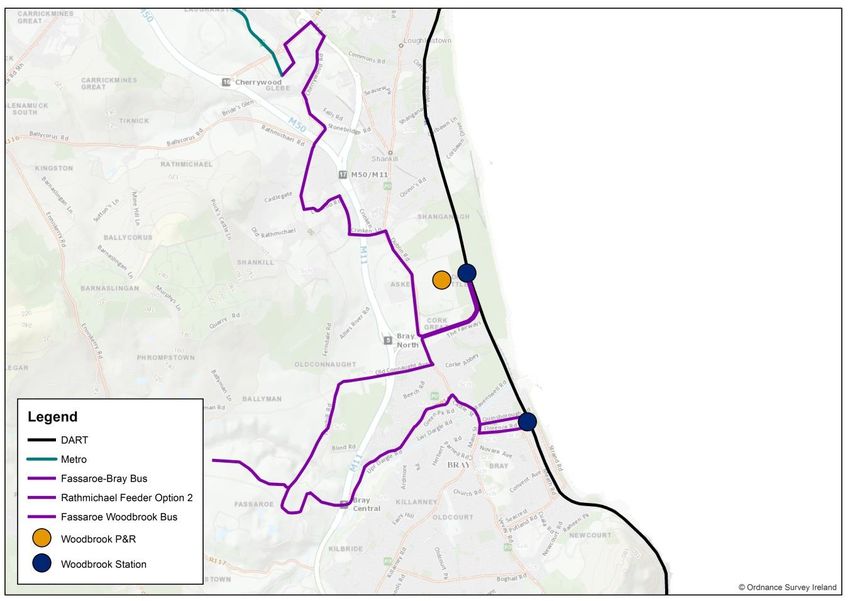
2019 Bray and Environs Transport Study                                   NTA TII WCC DLRCC

3     Implementation
3.1 Introduction
This section sets out the timelines for the implementation of the preferred approach identified by
this Study within the period of the Transport Strategy up to 2035 taking account of requirements
established in Section 2 of this study. A more detailed phasing and implementation plan – linked
formally to the growth of each development area – is recommended to be developed subsequent
to this plan, with the exception of the initial development phase for Fassaroe, measures for which
are recommended below.
A key assumption in this regard is that any significant development of Rathmichael, and the
growth of Old Connaught and Woodbrook beyond the residential zonings set out in the current
Dún Laoghaire-Rathdown Development Plan, will only occur after 2027. This section is based on
the current work being undertaken by the NTA on the on-going capital investment programme; TII
National Roads Schemes in the National Development Plan; BusConnects; work being undertaken
in conjunction with the local authorities as part of the Sustainable Transport Measures
Programme; and the work previously undertaken for the Transport Strategy.
In considering the implementation of the preferred approach, it must be borne in mind that Bray
and its Environs – despite being identified in the Draft Regional Spatial and Economic Strategy as a
Key Town which “… has the capacity and future growth potential to accommodate above average
growth” - comprises but only one of a number of such development areas throughout the Greater
Dublin Area which require investment in transport infrastructure and services. The development
areas within the study area to the west of the N11/M11 have very limited existing assets in this
regard. As such, their development would also require corresponding planning and design work to
be undertaken on each of the relevant transport measures. Timelines for their full delivery would
also need to be confirmed.
For all schemes, regardless of where responsibility for delivery ultimately lies, each one would
require agreement and cooperation between the agencies. In the case of some local authority
schemes, these are likely to be managed with the NTA under the Sustainable Transport Measures
Grants programme and TII under government funding allocations with regard to national road
schemes. All of the schemes below would be also be funded in part by contributions levied against
development in the study area.

3.2      First Growth Area – Phase 1 (a) Fassaroe
Phase 1 (a) of the development of Fassaroe would comprise c.650 residential units and
appropriate residential support facilities. The measures required to deliver this development are
set out in Table 3.1 below. These would be agreed between the applicant, Wicklow County
Council, the NTA and TII and are recommended to be be subject to monitoring and review with a
view to their improvement and alteration as investment in future phases is realised, in particular
Woodbrook DART station and the extension to Bray of the Luas.
Due to the need to address the impact of any proposal on the existing congested national road
network in advance of NDP N11/M11 Junction 4 to Kilmacanogue – Junction 14 Improvement
Scheme, it would be necessary for Wicklow County Council, in agreement with TII, to prepare a
framework for a Traffic Management System to facilitate phase 1(a) development of the Fassaroe
lands. it is recommended that the agreed framework includes in its scope the identification of
traffic management measures and infrastructure to minimise the impact of the Fassaroe proposal
on the mainline the N/M11 and to enhance Wicklow and TII’s ability to manage traffic flow on the
N11 corridor pending future national road schemes. This Framework is recommended to be
undertaken within two months of the date of the agreement of this Study .

                                                                                                  9
2019 Bray and Environs Transport Study NTA TII WCC DLRCC
Recommended framework measures will include appropriate agreed controls for merging traffic
on to the N11 mainline, public transport priority and additional monitoring equipment.
Table 3.1 – Transport Requirements for Phase 1 of Fassaroe
Infrastructure or Delivery Process Work Commenced Completed to a
Service Standard to be Taken
in Charge
Fassaroe Part of Planning Prior to Occupation of Prior to Occupation of
Development Roads Application any dwellings any dwellings
N11 Cycle and Part of Planning Prior to Occupation of Prior to Occupation of
Pedestrian Bridge Application any dwellings any dwellings
Traffic Management Wicklow County Prior to Occupation of Prior to Occupation of
Measures at Fassaroe Council Traffic any dwellings any dwellings
Interchange arising Management System
from the Framework to be
development agreed with TII within
2 months of the
agreement of the Bray
Study .
New bus services in Part of Planning Phased introduction n/a
line with demand Application with as dwellings are
agreement of NTA completed
Bus Priority on Upper In conjunction with Prior to occupation of n/a – WCC Scheme
Dargle Road including Phase 1(a) any dwellings
the approach to development
Sunnybank Junction
Bus priority on Dublin Prior to occupation of Prior to occupation of n/a – WCC / NTA
Road – Castle Street 50% of Development 100% of Development Scheme
In addition to above, it is recommended that any application for the development of the Fassaroe
lands demonstrate the following:
a) That the proposed development provides fully for walking and cycling trips to all local
services within Fassaroe;
b) That the applicant will provide a bus service to Bray DART station in advance of demand
justifying public investment as part of the expansion of the bus network under
BusConnects;
c) That the applicant has fully assessed a requirement for a bus service to Bride’s Glen or
Cherrywood Luas and provides same if demand is deemed sufficient in advance of demand
justifying public investment as part of the expansion of the bus network under
BusConnects;
d) That the applicant demonstrates how demand for travel to schools from Fassaroe can be
accommodated without undue recourse to the private car;
If the above elements are delivered and demonstrated, the development of Phase 1 of Fassaroe
would be regarded by TII and the NTA as a development which:
102019 Bray and Environs Transport Study NTA TII WCC DLRCC
(i) Is sufficiently served by public transport, walking and cycling;
(ii) Would not be excessively car-dependent;
(iii) Would not adversely impact on the safe and efficient operation of the national road
network;
(iv) Would not adversely impact on the carrying capacity and strategic function of the national
road network; and
(v) Demonstrates close integration between transport planning and land use planning.
As such, the development of c.650 residential units and appropriate residential support facilities
on the lands at Fassaroe on this basis could be considered to be consistent with the Transport
Strategy for the Greater Dublin Area and DHPLG’s Spatial Planning and National Roads Guidelines
for Planning Authorities.
3.3 Further Phases of Fassaroe
Table 3.1 sets out an approach that would help to facilitate the immediate development of
Fassaroe to provide for c.650 residential units. Further phases of the build out of these lands are
recommended to be governed by a separate implementation and monitoring plan to be developed
by Wicklow County Council with input from the NTA and TII. Whereby such a plan has been agreed
with all agencies, the full build-out of Fassaroe could proceed on that basis.
3.4 Bray and Environs Development Phase A – 2019-2027
In Phase A, the agencies (NTA, TII, WCC, DLRCC), subject to the considerations set out in Chapter 2,
would seek to deliver the following:
Woodbrook DART Station and Park & Ride;
Increased DART frequencies;
Metrolink;
Introduction of bus services linking Fassaroe to Woodbrook;
Framework for interim Traffic Management System for the N11;
N11 capacity and safety upgrades;
Progression of N11/M11 Junction 4 to 14 Improvement Scheme
Bray (Dublin Road) Core Bus Corridor incl. Castle Street Bridge and junction improvements;
Bus Connects Network Review;
Bus Service from Bride’s Glen to Bray via Rathmichael and Old Connaught;
Golf Club Development Roads including Dargle bridge for use by buses, pedestrians and
cyclists;
Busway from Fassaroe to Old Connaught over County Brook at Ballyman Glen;
Development of new road link from Ferndale Road to Dublin Road;
New road link from the M50 Cherrywood Interchange to Rathmichael;
Upgrades to local roads serving Old Connaught to facilitate bus, pedestrian and cycle
movements, as required by development;
A Feasibility Assessment of the Bridge from Upper Dargle Road to Herbert Road; and
Bus Priority on Killarney Road.
3.5 Bray and Environs Development Phase B – 2028-2035
In Phase B, the agencies, subject to the considerations set out in Chapter 2, would seek to deliver
the following:
Increased service frequency on bus services in line with demand;
112019 Bray and Environs Transport Study NTA TII WCC DLRCC
Luas to Bray;
N11/M11 Junction 4 to 14 Improvement Scheme
Demand Management on the M50 and M/N11;
Bridge from Upper Dargle Road to Herbert Road; and
Upgrades to local roads serving Rathmichael to facilitate bus, pedestrian and cycle
movements, as required by development.
3.6 Current Public Transport Programme
As of 2018, the investment programme of the NTA includes the following elements of the
preferred approach, as identified by this study:
Increased DART Frequencies (implemented);
Planning and Design for Metro;
Bray Core Bus Network; and
Bus Connects Network Review.
All of the other schemes and measures are recommended to be subject to the direct provision by
developers; further investment programmes over the period of the Transport Strategy; further
collection of development contributions; planning and design work; cost benefit analysis;
environmental assessment; and the planning consent process where applicable. Potential for fast-
tracking certain elements of the programme exists, as does the potential for some elements to be
delivered at a later date.
3.7 Bray Municipal District Local Area Plan 2018
The Bray Municipal District Local Area Plan was adopted in May 2018. The following measures /
objectives of the plan would facilitate and promote the implementation of all of the transportation
interventions and actions recommended in this study which apply to the Bray Municipal District:
3.7.1 Public Transport
BUS: This study identifies the requirement to enhance and improve bus services from and into
Bray town centre from all directions, but particularly along the Dublin-Bray Core Bus Corridor
(Dublin Road – Castle Street), Killarney Road and Dargle Road, connecting to Bray Station, in order
that high frequency services can be provided. Objectives PT1, PT2, PT3, PT7 and R07 would
support and facilitate the delivery of the necessary public transport facilities and road and traffic
management interventions, required to deliver these enhanced bus services. These include, but
are not limited to the provision of bus lanes and the management of on-street parking. In this
manner, the LAP would help to facilitate the implementation of the suggestions included in this
study and the delivery of the NTA’s public transport programme.
RAIL / BRAY STATION INTERCHANGE: This study identifies the need to develop a high quality rail /
Luas / bus interchange at Bray Station; objectives PT1, PT2, PT3, PT4, R05 and Zoning Objective
GTH support and facilitate this objective.
LUAS: This study identifies the need to facilitate the extension of the Luas Green Line to Bray town
centre via the golf club lands, including a new public transport bridge over the River Dargle. This is
provided for in the LAP through objectives PT1, PT2, PT3, PT5 and ‘Specific Local Objective 3 – Bray
Golf Course’
3.7.2 N/M11
This study identifies the need for N/M11 capacity and safety upgrades, and junction improvements
from J4 to J14. It also identifies an interim requirement to manage traffic at the Fassaroe
Interchange in order to protect the strategic function of the N/M11. The LAP supports and
122019 Bray and Environs Transport Study NTA TII WCC DLRCC
facilitates said improvements through Objective R01 which provides for capacity and operational
improvements, removal or reconfiguring of existing direct accesses and left on / left off junctions,
upgrades to the regional / local road network to provide improved access between existing
M11/N11 mainline junctions and regional / road network and through Objective R02.
3.7.3 Walking & Cycling
This study identifies the need for enhancement of walking and cycling infrastructure, and in
particular connections to bus corridors and transport interchange points. Such improvements are
supported in the LAP via Objectives CW1, CW2, CW3, CW4 and R09, R10.
3.7.4 Fassaroe
This study sets out the roads and transportation requirements to facilitate the development of
Fassaroe, west of the N11; in particular the delivery of mass public transit to the area with
connections to Bray town centre, Bray station, Old Connaught and Woodbrook DART. The LAP
makes provision for all of the interventions required to deliver such a services, in particular
through delivery of Objectives PT1, PT2, PT3, PT5, PT7, R01, R02, R04, R07, R10.
The development of Phase 1 (a) of Fassaroe is recommended to be undertaken in a manner
consistent with section 3.2 of this study. Further development is recommended to be subject to
the development of an implementation plan by WCC in collaboration with NTA and TII.
3.8 Recommendations for Dún Laoghaire-Rathdown County Council
For the same reason as provided in section 3.7, it is recommended that any statutory land use plan
in Dún Laoghaire-Rathdown reflects the following objectives:
- To develop Woodbrook DART station and Park & Ride;
- To upgrade the road system in Rathmichael and Old Connaught in order to facilitate safe,
convenient and reliable movement of public transport vehicles, cyclists and pedestrians
including;
o Upgrade of Ferndale Road;
o Development of new road link from Ferndale Road to Dublin Road;
o Cherrywood to Rathmichael link road;
- To provide for a busway from Fassaroe to Old Connaught over County Brook at Ballyman
Glen which facilitates walking and cycling;
- To support the delivery of a bus service from Sandyford to Bray DART station via Old
Connaught and Rathmichael until such time as the Luas Green Line extension to Bray is
suitably advanced;
- To facilitate the implementation of demand management measures on the N/M11 and
M50;
- To facilitate the delivery of Metro to Sandyford and Luas to Bray; and
- To facilitate a new road link from the M50 Cherrywood Interchange to Rathmichael.
3.9 Next Steps
The NTA recommend that the statutory plans of Wicklow County Council and Dún Laoghaire-
Rathdown County Council are amended, where necessary, in order to reflect this study fully. As an
input into this process, the NTA will publish a budgetary programme of investment for the Bray
and Environs area that includes transport projects, such as the BusConnects network review and
bus infrastructure schemes, that are already established as public policy by other plans,
programmes, and strategies.. It is recommended that similar programmes are set out by TII for the
N/M11 upgrades and the local authorities for their schemes. In relation to the development of
132019 Bray and Environs Transport Study NTA TII WCC DLRCC
further phases of Fassaroe, it is recommended that Wicklow County Council produce an
implementation and phasing plan with inputs from TII and NTA.
142019 Bray and Environs Transport Study NTA TII WCC DLRCC
Appendices
Study Development
152019 Bray and Environs Transport Study NTA TII WCC DLRCC
A. Baseline
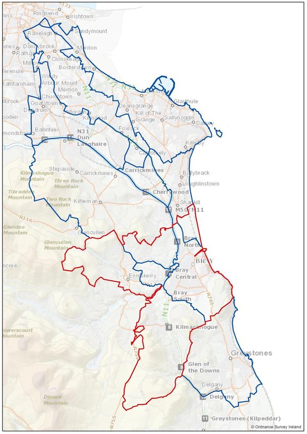
(i) Study Area
The Study Area covers an area of c. 5,409 hectares straddling the Wicklow and Dublin border. It
includes the development areas of Woodbrook / Shanganagh, Old Connaught and Rathmichael in
Dún Laoghaire-Rathdown, and Fassaroe in Wicklow. It also includes the entire settlements of Bray,
Enniskerry and Kilmacanogue. In the case of the latter, their large rural hinterlands are also
included in the area calculation. The major transport features of the study area are the N/M11
national road and the East Coast Rail line. The former acts as the current western boundary to the
built-up area, with the latter defining the eastern coastal boundary. A number of regional roads
make up the distributor road network within Bray, with the rest of the area defined by regional,
local and rural roads. The study area is shown in Figure A1 below:
Figure A1: Study Area
Rathmichael Woodbrook / Shanganagh
Old Connaught
Bray
Enniskerry
Fassaroe
Kilmacanogue
162019 Bray and Environs Transport Study NTA TII WCC DLRCC
(ii) Existing Public Transport
Existing Public Transport Network and Services
The eastern flank of the study area is well served by public transport. Bray Station is served by
DART and Commuter rail with 17 peak period services daily towards the City Centre, including
DART services to Malahide / Howth.
The Dublin Road / N11 corridor is a key bus route. It is served by the 145, 84/A and 45A services.
The 84X uses the M11 to reach Greystones without serving Bray. The 185 links Enniskerry to Bray
Station and the 184 links Newtownmountkennedy. Enniskerry is linked to the City Centre by the
44. Of these, only the 145 is a high frequency service linking the study area to Dublin City Centre.
Bus Éireann route 133 links Wicklow to Dublin Airport via the M/N11, with off-peak services
running via Bray Main Street.
Figure A2: Existing Public Transport Network and Services
145
45A
DART / Commuter Rail
44
84/A
185
133
84X
184
172019 Bray and Environs Transport Study NTA TII WCC DLRCC
(iii) Existing Road Network
The study area is defined by the N/M11 national road which runs through its centre in a north-
south direction. This route links Dublin to Wexford via Wicklow and acts as the spine for the south-
east of Ireland.
Bray is defined by a number of regional routes which form a triangle with the town hall at its
northern apex. These are the Southern Cross R768, Vevay Road R761 and the Killarney Road R767.
From the town hall northward the R761 Dublin Road connects the town to Shankill and Dublin via
the R119 and N11.
In the western side of the study area, the road network is primarily rural in nature, but can be
defined loosely by the north-south R760 Enniskerry Road and in terms of a number of east-west
routes as follows. To the north, the Old Connaught Avenue – Ballyman Road comprises a spine
upon which the development area of Old Connaught hangs. The Upper Dargle Road – Fassaroe link
via what is currently Berryfield Lane provides the connection between Bray and the Fassaroe
Masterplan lands. Through the centre of the Study Area, the R117 links the N11 and Bray to
Enniskerry, while the R755 which links Kilmacanogue with Roundwood defines the southern
portion of the Study Area.
(iv) Existing Road Network Operation
The following image shows the level of peak hour congestion on a typical morning in the study
area, based on traffic speeds experienced in the AM peak hour relative to that experienced at
night time. This data has been extracted from Tom-Tom sat-nav outputs. It shows that Bray
experiences moderate to severe congestion on several links, most notably Dublin Road and the
southern M11 junction.
182019 Bray and Environs Transport Study NTA TII WCC DLRCC
Figure A3: Existing levels of Congestion
Woodbrook / Shanganagh
Old Connaught Bray
Fassaroe
Enniskerry
Kilmacanogue
Greystones
192019 Bray and Environs Transport Study NTA TII WCC DLRCC
(v) Land Use and Transport Planning Context
Land Use Planning
Land use planning policy in the Study Area is determined by the following documents:
- Project 2040 National Planning Framework ;
- Draft Regional Spatial and Economic Strategy for the Eastern and Midland Region;
- Dún Laoghaire-Rathdown Development Plan 2016-2022;
- Wicklow County Development Plan 2016-2022;
- Bray Municipal District Local Area Plan (2018-2024); and
- Woodbrook / Shanganagh Local Area Plan 2017-2023
Together these plans envisage significant growth in the Study Area. Between the Old Connaught
and Fassaroe development areas, an additional population of c.16,000 is catered for either by land
use zonings or by stated long-term aims of the local authorities, with the latter also potentially
yielding 3,000, jobs according to the Draft Bray Municipal District Local Area Plan. The lands of the
former Bray Golf Club, close to the town centre, comprise another key residential and commercial
development site, while Woodbrook / Shanganagh and Rathmichael could cater for a combined
population of c.11,000 by 2035.
Transport Planning
Apart from the land use planning documents highlighted above transport planning in the Study
Area is informed by the following:
Government of Ireland, Project 2040 National Development Plan (NDP) 2018
The purpose of the National Development Plan is to set out the new configuration for public
capital investment over ten years to secure the realisation of each of the National Planning
Framework (NPF) National Strategic Outcomes (NSOs). The NDP includes major transportation
projects to enable NSO’s including BusConnects, Metrolink, Luas extension to Bray, and the
progression through pre-appraisal and early planning of a national roads scheme for M11 from
Junction 4 to Kilmacanogue – Junction 14.
NTA Transport Strategy for the Greater Dublin Area 2016-2035
The Transport Strategy for the Greater Dublin Area 2016 – 2035 (the “Strategy”) sets out the
strategic infrastructure and services proposed to be delivered over the next 20 years. The
following outlines some of the transport proposals included in the Strategy, some of which have
since been developed further and which will affect the study area:
Heavy Rail:
o DART expansion programme; and
o Higher frequency services.
Light Rail:
o Metro South; and
o Luas to Bray.
Bus:
o Core Radial Network from Bray to UCD.
202019 Bray and Environs Transport Study NTA TII WCC DLRCC
Cycling:
o Greater Dublin Area Cycle Network.
Walking:
o Improvements to provide safer, more comfortable and convenient.
Road:
o National Road Scheme Improvements; and
o Regional and Local Road Improvements, including roads to cater for local traffic.
Demand Management; and
Park and Ride at Woodbrook.
NTA BusConnects
The most significant progress which has been made since the Transport Strategy’s approval, and
which is of direct relevance to the Study Area, has been the launch and development of the
BusConnects programme. This programme has several strands, but the most significant two in
terms of this study are as follows:
Core Bus Network – the NTA is preparing preliminary designs for a number of Core Bus
Corridors (CBC) with a view to seeking full bus priority in both directions. The Bray CBC
runs from Castle Street to Dublin City Centre. Greater clarity on this element of
BusConnects will emerge through 2018; and
Dublin Metropolitan Bus Network Review – the NTA is currently undertaking a major and
fundamental review of the Dublin Public Service Obligation (PSO) network with a view to
making it more efficient and in order to increase patronage. This will have an impact on
the services in the Bray environs, and will be rolled out from 2019. It should be noted that
the network which emerges from this exercise will not constrain this study’s proposals for
2027 or 2035, as the travel demand environment will have changed significantly by these
study’s horizon years.
Transport Infrastructure Ireland – M11 / N11 Corridor Study Needs Assessment Report
This non statutory TII study was published in November 2016. The function of this study was to
outline possible measures which could address the needs recognised by TII and the NTA associated
with the M11/N11 road corridor; and present a potential overall strategy in terms of delivery and
implementation; while aligning with the objectives set out in DTTaS Strategic Investment
Framework for Land Transport (SIFLT) .
The document sought to set out a number of national roads proposals but also considered the
needs of the regional and local road network and public transport to address both the existing
transport issues on the N/M11 corridor, and those which are forecast to emerge up to 2030 and
2050. While the study indicated a significant investment in roads within the study area, this study
also sought to exploit this investment for use by public transport to the maximum extent possible,
both by using the additional capacity but also by prioritising public transport where capacity
emerges elsewhere on the network as a result of this investment.
212019 Bray and Environs Transport Study NTA TII WCC DLRCC
Department of Environment Heritage and Local Government Spatial Planning and National Roads
Guidelines for Planning Authorities
In relation to development planning and national roads, the above Section 28 guidelines contain
the following key messages of relevance to this study:
Development plans must include measurable objectives for securing more compact
development that reduces overall demand for transport and encourages modal shift
towards sustainable travel modes;
Development plans must include policies which seek to maintain and protect the safety,
capacity and efficiency of national roads and associated junctions, avoiding the creation of
new accesses and the intensification of existing accesses to national roads where a speed
limit greater than 50 kph applies;
Planning authorities and the NRA must work together during the early stages of plan
preparation to identify any areas where a less restrictive approach may apply;
Development plans must include clear policies and objectives with regard to planning and
reservation of new routes and/or upgrades; and
Planning authorities should consult at a very early stage with transport infrastructure
providers (including TII ) and, in the Greater Dublin area, with the National Transport
Authority.
222019 Bray and Environs Transport Study NTA TII WCC DLRCC
B. Travel Demand
This chapter sets out the travel demand for the Study Area that will be used for deriving a
preferred approach for the study. This process is an interim high-level step in advance of the use of
the full ERM to determine the full demand level, trip distribution and mode share. It takes into
account the GDA Transport Strategy travel demand levels, revised development proposals, and
AM peak hour demand only. It is based on a number of broad assumptions related to future mode
splits, which are detailed in section 3.2.3.
(vi) Establishing Demand
The assignment model demand matrices from a previous 2035 Do Strategy ERM run were used as
the basis upon which the demand analysis was undertaken. The demand for the Study Area in the
previous 2035 Do Strategy ERM run includes previously assumed development for the Study Area.
The demand associated with the Study Area has been factored and adjusted to take into account
revisions to the land-use scenario, based on more precise planning data which has emerged since
the making of the Strategy. These revisions were undertaken with the agreement of Wicklow
County Council and Dún Laoghaire-Rathdown County Council.
(vii) Developing Demand Expansion Factors
In order to factor the demand matrices to align with the more precise land use proposals, a
comparison was undertaken to determine the land use changes and their implications for the AM
Peak period trip ends. Table B1 outlines a comparison of the population, job numbers and
education places for the Study Area for the previous 2035 Do Strategy and the revised Land Use
scenarios. The table also includes a comparison of the total production and attraction trips ends
for each land use scenario.
It can be seen that for the Study Area the revised land use scenario results in a significant uplift to
the trip ends. The trip end production and attraction percentage increases were applied to the
origins and destinations for the trip matrices for the AM peak hour for the Study Area.
This uplift is primarily due to significant additional growth being forecast in the Dún Laoghaire-
Rathdown sectors of the study area. Between Old Connaught, Rathmichael and Woodbrook, the
2035 population forecast is now approximately 20,000. The original Strategy forecasts equated to
approximately half that number.
Table B1: Comparison of Land-Use Scenarios and Trip Ends
Study Area Study Area
2035 Do 2035 Revised
Strategy
Population 59,999 69,972
Jobs 14,223 20,615
Education 12,024 13,845
TE Production 38,589 46,180
TE Attraction 34,872 36,713
232019 Bray and Environs Transport Study NTA TII WCC DLRCC
(viii) Demand Analysis
Sectors
In order to analyse the demand for travel to and from the Study Area, sectors external to the study
area have been identified. In this manner, we can determine the demand for travel to and from
Dublin City Centre, other sectors within the region, and detailed sub-sectors which we would
anticipate to have a close relationship with the study area. Figure B1 and B2 outline the sectors
and those sub-sectors closer to the study area.
242019 Bray and Environs Transport Study NTA TII WCC DLRCC
Figure B1: Greater Dublin Area Sectors
Meath
Dublin
Kildare
Study Area
Wicklow
252019 Bray and Environs Transport Study NTA TII WCC DLRCC
Figure B2: Sub-Sectors
Dublin City Centre
F1 N11
Dún Laoghaire
F1 Luas F1 DART
F2 Cabinteely
F2 North F2 DART
F2 Cherrywood
Bray
Study
Area
F2 South
262019 Bray and Environs Transport Study NTA TII WCC DLRCC
AM Peak Hour Demand Sector Distribution
Table B2 outlines the person trip totals to and from the Study Area as distributed based on the
origin or destination sectors. The distribution of these trips to and from the sectors through the
GDA is set out, as is the percentage of the total demand associated with trips to or from the
sectors.
Table B2: AM Peak Hour Person Trips Demand Distribution
Sector Trips From Study Percentage From Trips To Percentage To
Area Study Area Study Area Study Area
A1 424 1% 132 0%
A2 276 1% 79 0%
A3 9 0% 21 0%
B1 134 0% 60 0%
B2 84 0% 64 0%
B3 8 0% 16 0%
C1 152 0% 36 0%
C2 128 0% 85 0%
C3 1 0% 7 0%
D1 498 1% 110 0%
D2 372 1% 149 0%
D3 7 0% 39 0%
E1 701 2% 326 1%
E2 184 0% 174 0%
E3 8 0% 62 0%
F1 7357 16% 2,021 6%
F2 31,473 68% 28,782 78%
F3 1,686 4% 4,053 11%
G 2,378 5% 196 1%
H 290 1% 50 0%
External 8 0% 252 1%
Total 46,180 100% 36,713 100%
Figure B3 shows a more detailed breakdown of the above data for trips FROM the Study Area to
Dublin City Centre and to the subsectors of sectors F1 and F2, as identified in Figure 3.2. These
trips are shown in the green boxes. This trip pattern was chosen as it equates to the highest level
of demand, and therefore any public transport solution derived to serve trips originating in the
Study Area could be therefore assumed to serve trips with their destinations in the Study Area.
272019 Bray and Environs Transport Study NTA TII WCC DLRCC
This analysis is aimed at devising public transport options for serving the demand from the Study
Area.
Figure B3: 2035 Am Peak Hour Demand to Subsectors
Dublin City Centre
Dún Laoghaire
Bray
Mode Split Assumptions
The sections below illustrate how the above demand relates to the main corridors to the north of
the study area, i.e. Luas, N11 and DART, and its transport implications. The methodology for
deriving these figures is based on the following assumptions:
That all growth in demand from 2011 to 2035 is catered for by public transport; and
An assumed mode split between each public transport option which reflects the
geographic relationships between each subsector and public transport options.
282019 Bray and Environs Transport Study NTA TII WCC DLRCC
The tables below and Figure B4 show how these assumptions were applied:
Table B3: Assumed Mode Split between Public Transport Modes – 2035
Trip Pattern by Mode Split - 2035 Assumed PT Split
Study Area to Subsector / Mode Split Bus Luas DART
G City Centre 25% 38% 38%
H Docklands 38% 0% 63%
F1 Luas 0% 100% 0%
F2 Cabinteely 50% 50% 0%
F2 Cherrywood 43% 57% 0%
F1 N11 100% 0% 0%
F1 DART 0% 0% 100%
F2 DART 14% 0% 86%
Table B4: Additional Demand by Mode
Study Area to Subsector 2011 2035 Growth Bus Luas DART
G City Centre 1163 2338 1175 294 441 441
H Docklands 137 283 146 55 0 91
F1 Luas 1189 2415 1226 0 1226 0
F2 Cabinteely 144 235 91 45 45 0
F2 Cherrywood 307 1375 1068 458 610 0
F1 N11 1244 1721 477 477 0 0
F1 DART 1838 2911 1073 0 0 1073
F2 DART 787 1808 1021 146 0 875
TOTAL 6809 13085 6276 1475 2322 2479
These figures, when added to the 2011 demand, lead to an assumed 2035 car mode share of 52%
from the Study Area to these selected locations and a public transport mode share of 48%. The
mode split for car for work trips – which make up the majority of AM Peak external trips – from
Bray in 2011 was 61%. As such, the mode split figures emerging from this analysis are deemed
reasonable in the context of the delivery of significantly enhanced alternatives to the private car
for travel in 2035.
This approach can then be applied to essentially set out a framework methodology for examining
public transport options. This is set out in Figure 3.4, which shows the number of trams required in
the AM peak hour to serve the additional demand to the Luas corridor; the number of buses
required to serve additional demand to the N11; and the number of trains required for the DART
corridor. Critically, the need to connect the Luas, Core Bus Corridor and DART stations to the
residential areas of the Study Area by means of feeder buses, must also be considered.
292019 Bray and Environs Transport Study NTA TII WCC DLRCC
Figure B4: Demand to the Subsectors north of Study Area and Transport Implications
302019 Bray and Environs Transport Study NTA TII WCC DLRCC
Distribution within the Study Area
In order to get a more detailed picture of travel demand within the study area, 2035 demand was
examined further. This included the isolation of the demand crossing the Bray Western Screen, i.e.
all demand travelling from Old Connaught, Enniskerry and Fassaroe into Bray. This Western Screen
represents the relationship between Old Connaught and Fassaroe, and Bray. The latter is the key
service centre for the former two major development areas and Enniskerry, with potential
transport interchange for onward travel also a consideration. The quantum of trips travelling from
Bray to Fassaroe and Old Connaught also emerges as a key consideration, as do the trips internal
within Bray, Old Connaught and Fassaroe. Travel from Woodbrook to Bray as well as internal trips
within Woodbrook also emerges as a factor for consideration.
Table B5: 2035 AM Peak Hour Demand within the Study Area
Old
Study Area Bray Enniskerry Fassaroe Kilmac Connaught R’michael Woodbrook
Bray 12,938 151 870 282 635 50 165
Enniskerry 209 198 35 13 245 3 6
Fassaroe 1,728 65 1,780 83 498 8 23
Kilmacanogue 492 14 55 122 74 2 5
Old
Connaught 1,167 254 358 57 1,978 42 37
Rathmichael 351 17 33 10 146 27 18
Woodbrook 661 11 36 11 48 7 550
312019 Bray and Environs Transport Study NTA TII WCC DLRCC
C. Public Transport Option Development
(ix) Overview
With the high-level demand analysis of Chapter 3 in mind, this chapter outlines the public
transport options for the Study Area. For the purposes of this report, it is assumed that all
pedestrian and cyclist movement will be catered for on the road network and that measures to
address issues on the N/M11 in line with the recommendations of TII will be developed in the
long-term. It should be borne in mind that due to the physical constraints of the study area, and
the operational constraints of the 2035 transport network in terms of serving the requirements of
the entire Metropolitan Area, the range of options available which are both feasible and which
meet the additional demand, are extremely limited.
Options
The following lists the public transport options that could be considered to meet the additional
target demand for the Study Area:
Option 1 - Light Rail
a. Luas spur to Fassaroe as per previous Line B2 proposal;
or Luas Alternative Routeing via Ferndale Road
b. Feeder Bus from Fassaroe to Bray DART; and
c. Feeder Bus from Bride’s Glen to Bray DART via Rathmichael (subject to Luas
routeing).
Option 2 - DART
a. Enhanced DART services to Bray;
b. New Station and Park and Ride at Woodbrook;
c. Feeder Bus from Bride’s Glen to Woodbrook DART via Rathmichael;
d. Feeder Bus from Fassaroe to Woodbrook DART via Old Connaught; and
e. Feeder Bus from Fassaroe to Bray DART.
Option 3 - Bus
a. Core Bus Corridor from Bray DART Station to City Centre;
b. High-Frequency Bus Services from Fassaroe to Bray DART; and
c. High-Frequency Bus Services from Fassaroe to Bride’s Glen via Old Connaught and
Rathmichael
322019 Bray and Environs Transport Study NTA TII WCC DLRCC
(x) Option 1: Light Rail
Option 1 is based on the extension of the Luas Green Line to Bray and Fassaroe via Old Connaught
along the B2 alignment, supplemented by a bus service from Fassaroe to Bray and from Bride’s
Glen to Bray to link the Rathmichael development area to Metro and DART. An alternative Luas
alignment could run through Rathmichael via Ferndale Road. As such, it includes the development
of bus priority along Upper Dargle Road. Luas would run at 10 minute frequencies during the peak
hour from both Bray and Fassaroe, combining to give a 5 minute frequency to Bride’s Glen Metro,
where interchange with the higher capacity service would happen. Fassaroe and Bride’s Glen /
Rathmichael would be linked to Bray via a 10-minute frequency bus service.
Figure C1: Option 1 – Light Rail
332019 Bray and Environs Transport Study NTA TII WCC DLRCC
(xi) Option 2: DART
Option 2 is based on the enhancement of the existing DART services to Bray and the development
of a new DART station and Park and Ride at Woodbrook station. Fassaroe would be served by bus,
with one service linking to Woodbrook via Old Connaught on a new Busway incorporating a bridge
over the County Brook, and another to Bray. Rathmichael would be linked to both Bride’s Glen
Metro and Bray DART via a feeder bus. DART frequencies would be increased to 5-minutes during
the peak hour. Feeder buses would also operate at 5 minute frequency.
Figure C2: Option 2 – DART
342019 Bray and Environs Transport Study NTA TII WCC DLRCC
(xii) Option 3: Bus
Option 3 is based on the provision of new bus services connecting to the City Centre and to DART
and Luas, with demand from Fassaroe, Rathmichael and Old Connaught to be met by interchange
with the rail system. A bus would depart from Fassaroe and Old Connaught to Bray every 5
minutes. Rathmichael would be served by a feeder bus from Bride’s Glen Metro to Bray DART
every 5 minutes, also interchanging with the Bray CBC on the N11 and Dublin Road. The Bray CBC
would operate at 5-minute frequencies in the peak hour and would be supplemented by 2 feeder
services at similar frequencies from south Bray.
Figure C3: Option 3 – Bus
(xiii) Assessment
It is not the intention to rule out any of the above options or services entirely. Instead this section
will highlight and explain the main considerations which apply in each case, providing some
direction as to why this study arrived at a preferred approach.
Option 1 – Light Rail – the extension of Luas to Bray, either via Rathmichael or via the B2 alignment
would be a relatively expensive scheme. The development of a spur line to Fassaroe would also be
expensive and would compromise the service quality and levels to Bray. The Luas B2 alignment
would also leave a significant section of Old Connaught / Rathmichael without services. The
reliance of this option on interchange for travel by high-quality public transport – by excluding a
Core Bus Corridor – would also be considered a drawback.
Option 2 – DART – this option also leaves a considerable section of Old Connaught / Rathmichael
without services. It also means all of the development areas to the west of the N/M11 would
require interchange with Metro or DART to access all locations outside the study area. There is
also a risk that the capacity of DART and Metro services will be would up by demand from Bray
352019 Bray and Environs Transport Study NTA TII WCC DLRCC
and environs. The reliance of this option on interchange for travel by high-quality public transport
– by excluding a Core Bus Corridor – would also be considered a drawback.
Option 3 – Bus – these measures, while combining to provide a spatially comprehensive network,
would be susceptible to risks related to reliability and capacity. In terms of reliability, the
confluence of a number of high-frequency services in the constrained network between Bray Main
Street and DART station may cause delays to services. Additionally, the need for passengers from
South Bray to interchange in Bray centre to get to Dublin City Centre is a weakness. The main
advantage of Option 3 is its comprehensive nature in that all locations are covered.
(xiv) Outcome
From the above considerations, the following principles emerge for this Study:
1. The need for full coverage; and
2. The requirement to protect capacity on DART and Metro;
It is also reasonable to assume certain elements of the above options will be developed even in
the absence of this study, as they form part of the Transport Strategy or have emerged during its
detailed implementation throughout 2016 and 2017, namely:
1. A Luas line to the Bray Environs;
2. Woodbrook DART Station and Park & Ride; and
3. An enhanced bus network as part of BusConnects.
As such, the preferred approach for the development of Bray identified by this Study takes a
number of elements from each of the three options; applies the principles above; and assumes the
development and roll-out of the strategy measures. The preferred approach is set out at the
beginning of this report.
36You can also read