Traffic Committee Meeting - Business Papers
←
→
Page content transcription
If your browser does not render page correctly, please read the page content below
BUSINESS PAPER

                 Traffic
                 Committee
                 Meeting
                 Tuesday 13 April 2021

                 Randwick City Council   1300 722 542
                 30 Frances Street       council@randwick.nsw.gov.au
                 Randwick NSW 2031       www.randwick.nsw.gov.au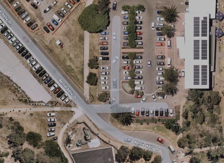
Traffic Committee meeting                                                                        13 April 2021

                                       TRAFFIC COMMITTEE
              Notice is hereby given that a Traffic Committee meeting of Randwick City Council
                                                 will be held on
                                      Tuesday, 13 April 2021, at 9:30am

COVID-19
IMPORTANT NOTICE: In order to protect the health of members of our community, the representatives of
other agencies and Council staff members, during the COVID-19 pandemic, the Traffic Committee
meetings are being undertaken as remote meetings - using MS Teams. The meeting starts at 9.30am.

Any members of the community, wishing to make representations regarding a matter listed within the Traffic
Committee Agenda, must email the Council (council@randwick.nsw.gov.au) at least 24 hours prior to the
meeting. Details on how to join the meeting would then be provided.

Traffic Committee
The following information is provided so that you may be aware of the structure and operation of the
Randwick City Traffic Committee.
-    The Randwick Traffic Committee is a Committee of Randwick City Council but not one set up under
     the Local Government Act.
-    Council has been delegated certain powers, from Transport for NSW (TfNSW), with regard to traffic
     matters upon its local roads. A condition of this delegation is that Council must take into account the
     Traffic Committee recommendations.
-    Recommendations in this document may either activate the formal delegation from Transport for NSW
     to the Council, or not activate this delegation. Items which activate the delegation are indicated with
     the initials (AD) below the heading.
-    There are four permanent members of the Traffic Committee, each of whom has a single vote only.
-    The members are: the NSW Police Service, Transport for NSW, the Local State Member of
     Parliament (for the location of the issue to be voted upon) and Randwick City Council.
-    Randwick City Council welcomes the public to attend and speak at its Traffic Committee on issues of
     concern.
-    If the Local Member disagrees with any of the Traffic Committee recommendations, they may appeal
     to Transport for NSW or the Minister for Roads.
-    If the Police or Transport for NSW disagrees with any of the Traffic Committee recommendations, or
     Council’s resolution on any Traffic Committee recommendation, they may lodge an appeal with the
     Sydney Regional Traffic Committee for determination. The appeal must be lodged in writing within 14
     days of the notification to the members of Council’s decision on the recommendation.
-    Any action relative to any issue under appeal must cease until the matter is determined.
-    The Sydney Regional Traffic Committee is chaired by an independent chairperson and submissions
     and representations are welcomed from all interested parties.
Acknowledgement of Country
The Chair will ask for a volunteer to acknowledge the lands upon which this meeting is being held:
         “I would like to acknowledge that we are meeting on the land of the Bidjigal and the Gadigal
         peoples; being the traditional owners who, for thousands of years, occupied and cared for vast
         areas along the Sydney Coast.
         On behalf of the participants of this meeting I acknowledge and pay my respects to the Elders
         past, present and emerging, and also to those Aboriginal people participating today.”
Traffic Committee meeting                                                                                                            13 April 2021

Attendance and Apologies
Declarations of Pecuniary and Non-Pecuniary Interests
Matters Arising from the Minutes OR from Council Resolution
Items for Consideration
At this time the Chair will ask those present at the meeting to nominate those items about which they
would like some discussion or elaboration.
The Recommendations on all other items, not so nominated, will then be put to the Committee for
endorsement.

Traffic Committee Reports
TC49/21        Proposed Interim Guidelines for implementation of Pedestrian Crossings ......................... 4
TC50/21        Boundary Street, Clovelly (C) ............................................................................................ 19
TC51/21        Byron Street and Coogee Bay Road, Coogee - Anzac Day March 2021.......................... 23
TC52/21        Coogee Bay Road, between Arden Street and Brook Street (C) ...................................... 25
TC53/21        Daintrey Crescent, Randwick (C) ...................................................................................... 27
TC54/21        Darley Road, Randwick (C) ............................................................................................... 29
TC55/21        Howard Street, Randwick (C) ............................................................................................ 31
TC56/21        Keith Street, Clovelly (C) ................................................................................................... 33
TC57/21        Lowe Street, Clovelly (C) ................................................................................................... 35
TC58/21        Surf Life Saving Club Patrol Parking (C & M) .................................................................... 39
TC59/21        Gardeners Road, Kingsford - Greek Easter 2021 (H) ....................................................... 43
TC60/21        Todman Avenue, at Balfour Road, Kensington (H) ........................................................... 47
TC61/21        Anzac Parade, La Perouse (M) ......................................................................................... 49
TC62/21        Australia Avenue, Matraville (M)........................................................................................ 51
TC63/21        Bernie Kelly Drive, South Maroubra (M) ............................................................................ 53
TC64/21        Elaroo Avenue, Philip Bay (M)........................................................................................... 55
TC65/21        Harold Street, Matraville (M).............................................................................................. 57
TC66/21        Percival Street, Maroubra (M) ........................................................................................... 59
TC67/21        Yarra Road, Phillip Bay (M) ............................................................................................... 61
TC68/21        Minor Signage Items - Parking and Regulatory - April 2021 (C, H & M) ........................... 77
TC69/21        Works Zone - Installation and Removal of Signage - April 2021 (C & H) ......................... 81
TC70/21        Parking Control Signage at Intersections - No Stopping (C, H & M) ................................. 83
TC71/21        Transport for NSW (TfNSW) Funded Project Status - April 2021 (C, H & M) ................... 85
General Business

                 (C) Coogee Electorate                (M) Maroubra Electorate                 (H) Heffron Electorate

                                                                                                          Tony Lehmann
                                                                                        MANAGER INTEGRATED TRANSPORT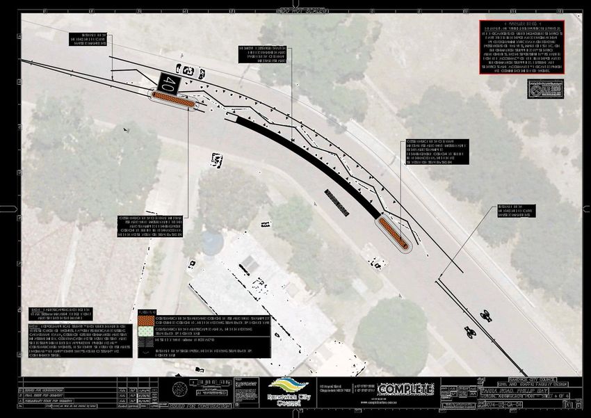
Attachment 1                                             Interim Pedestrian Crossing Guidelines Report - Parramatta Council - 13/1/2021

           Traffic Committee Report No. TC49/21

           Subject:           Proposed Interim Guidelines for implementation of Pedestrian
                              Crossings
TC49/21

           Index code     Trim Ref:      Category             Sub Category                                    By     AD
           2021.04.49     F2005/00825    Pedestrian           Marked Foot (Wombat) Crossing                   TL     Yes

          An issue which Councils have dealt with over many years is the introduction of pedestrian crossings upon
          local streets. Transport for NSW (TfNSW) and its predecessors (RMS, RTA etc.) have always maintained
          that quite strict numerical warrants must be met, prior to approval being given to the installation of a
          pedestrian crossing.

          However, TfNSW has recently informed Councils that the TfNSW supplements to the standards and
          guidelines have been written for state road application and do not apply to local roads. Therefore, the
          pedestrian crossing warrants do not apply to local roads and Councils have discretion to install pedestrian
          crossings, with referral to the Australian Standard and the Austroads guides. Council may choose to use
          the TfNSW warrants, however, they are under no obligation to do so.

          The challenge for Councils now is to ensure that the installation of pedestrian crossings results in safe and
          appropriate facilities.

          Parramatta City Council (PCC) has undertaken a thorough assessment of the various approaches to the
          installation of pedestrian crossings throughout Australia. As a result, they have developed interim
          guidelines for installation of pedestrian crossings. These guidelines reference the appropriate Australian
          Standards and Austroads approaches. Attached is a copy of a Parramatta Council report on the matter.
          The report recommends interim guidelines for implementation of pedestrian crossings. It also
          recommends further discussion amongst Councils to consider future enhancements to the interim
          guidelines.

          It is considered appropriate that Randwick Council adopt the interim guidelines, as developed by
          Parramatta City Council, and, that Randwick Council participate in ongoing discussions with other council
          to improve the guidelines over time.

           Recommendation

           That:

                 1. The interim pedestrian crossing implementation guidelines, as developed by Parramatta City
                    Council, are deemed as adopted for the implementation of pedestrian crossings within the
                    Randwick LGA, and,

                 2. Randwick Council officers participate in ongoing discussions with other councils to improve the
                    guidelines over time.

          Attachment/s:

           1.⇩          Interim Pedestrian Crossing Guidelines Report - Parramatta Council - 13/1/2021

          Responsible officer:          Tony Lehmann, Manager Integrated Transport

          File Reference:               F2004/08338

            Attachment 1 - Interim Pedestrian Crossing Guidelines Report - Parramatta Council - 13/1/2021                    Page 4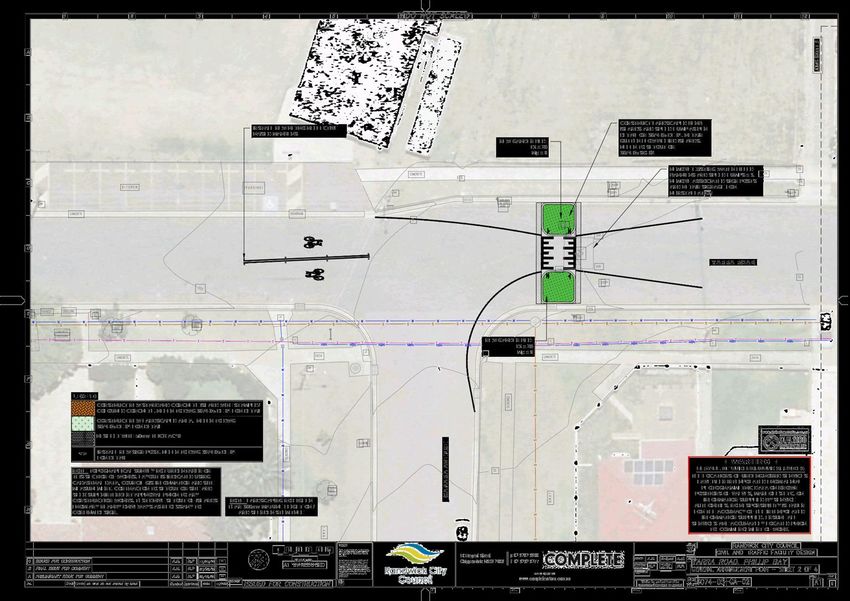
Interim Pedestrian Crossing Guidelines Report - Parramatta Council - 13/1/2021                 Attachment 1

                                                                                                               TC49/21

Attachment 1 - Interim Pedestrian Crossing Guidelines Report - Parramatta Council - 13/1/2021        Page 5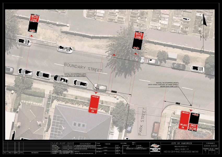
Attachment 1                                             Interim Pedestrian Crossing Guidelines Report - Parramatta Council - 13/1/2021
TC49/21

           Attachment 1 - Interim Pedestrian Crossing Guidelines Report - Parramatta Council - 13/1/2021                    Page 6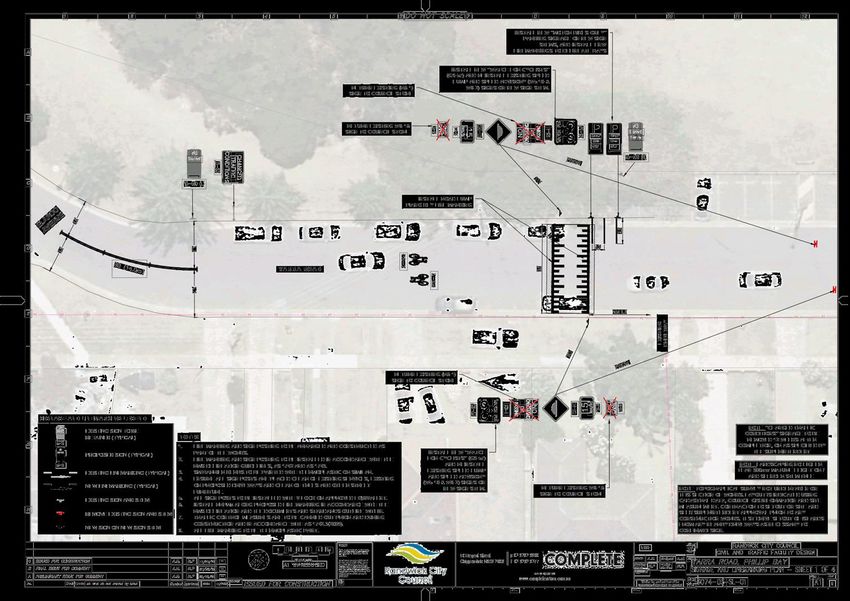
Interim Pedestrian Crossing Guidelines Report - Parramatta Council - 13/1/2021                 Attachment 1

                                                                                                               TC49/21

Attachment 1 - Interim Pedestrian Crossing Guidelines Report - Parramatta Council - 13/1/2021        Page 7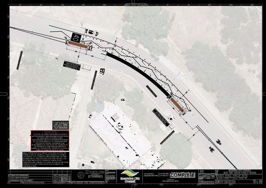
Attachment 1                                             Interim Pedestrian Crossing Guidelines Report - Parramatta Council - 13/1/2021
TC49/21

           Attachment 1 - Interim Pedestrian Crossing Guidelines Report - Parramatta Council - 13/1/2021                    Page 8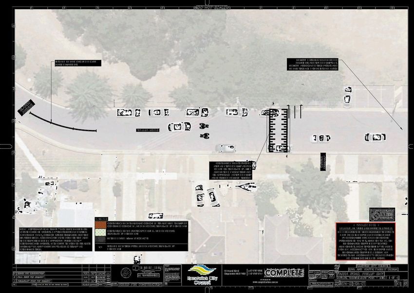
Interim Pedestrian Crossing Guidelines Report - Parramatta Council - 13/1/2021                 Attachment 1

                                                                                                               TC49/21

Attachment 1 - Interim Pedestrian Crossing Guidelines Report - Parramatta Council - 13/1/2021        Page 9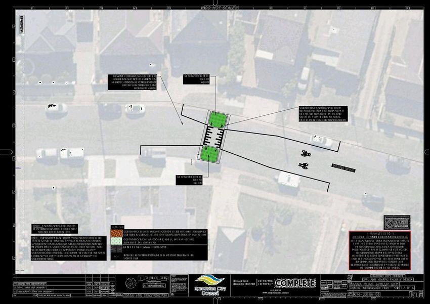
Attachment 1                                             Interim Pedestrian Crossing Guidelines Report - Parramatta Council - 13/1/2021
TC49/21

           Attachment 1 - Interim Pedestrian Crossing Guidelines Report - Parramatta Council - 13/1/2021                   Page 10
Interim Pedestrian Crossing Guidelines Report - Parramatta Council - 13/1/2021 Attachment 1
TC49/21
Attachment 1 - Interim Pedestrian Crossing Guidelines Report - Parramatta Council - 13/1/2021 Page 11Attachment 1 Interim Pedestrian Crossing Guidelines Report - Parramatta Council - 13/1/2021
TC49/21
Attachment 1 - Interim Pedestrian Crossing Guidelines Report - Parramatta Council - 13/1/2021 Page 12Interim Pedestrian Crossing Guidelines Report - Parramatta Council - 13/1/2021 Attachment 1
TC49/21
Attachment 1 - Interim Pedestrian Crossing Guidelines Report - Parramatta Council - 13/1/2021 Page 13Attachment 1 Interim Pedestrian Crossing Guidelines Report - Parramatta Council - 13/1/2021
TC49/21
Attachment 1 - Interim Pedestrian Crossing Guidelines Report - Parramatta Council - 13/1/2021 Page 14Interim Pedestrian Crossing Guidelines Report - Parramatta Council - 13/1/2021 Attachment 1
TC49/21
Attachment 1 - Interim Pedestrian Crossing Guidelines Report - Parramatta Council - 13/1/2021 Page 15Attachment 1 Interim Pedestrian Crossing Guidelines Report - Parramatta Council - 13/1/2021
TC49/21
Attachment 1 - Interim Pedestrian Crossing Guidelines Report - Parramatta Council - 13/1/2021 Page 16Interim Pedestrian Crossing Guidelines Report - Parramatta Council - 13/1/2021 Attachment 1
TC49/21
Attachment 1 - Interim Pedestrian Crossing Guidelines Report - Parramatta Council - 13/1/2021 Page 17Traffic Committee meeting 13 April 2021
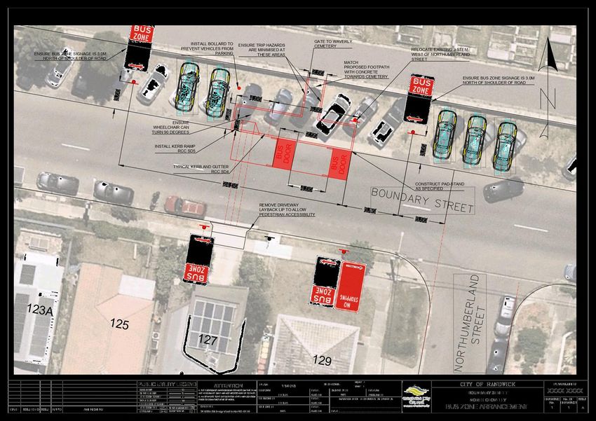
Traffic Committee Report No. TC50/21
Subject: Boundary Street, Clovelly (C)
TC50/21
Index code Trim Ref: Category Sub Category By AD
2021.04.50 D04133736 Signage Parking Bus Zone / No Stopping HH Yes
To improve services at the bus stop on the northern side of Boundary Street, west of
Northumberland Street, the State Transit Authority (STA) has proposed the construction of a
passenger waiting area. Subsequent to the construction of the waiting area, Bus Zone signposting
has also been recommended to reinforce No Stopping requirements as per Road Rule 195.
Additionally, the STA have proposed the installation of statutory No Stopping signage on the
southern side of Boundary Street, east and west of Park Street. This will help improve compliance
with the statutory No Stopping and bus draw-out requirements.
Recommendation
That:
1. a 30.0m Bus Zone be installed on the northern side of Boundary Street, 5.0m west of
Northumberland Street; and
2. No Stopping be installed on the southern side of Boundary Street, between points
10.0m west and 8.0m east of Park Street.
Attachment/s:
1.⇩ DRAWING Boundary Street (No Stopping and Bus Zone) arrangements
Responsible officer: Hong-Sanh Hua, Student Sustainable Transport Engineer
File Reference: F2004/07425
Page 19DRAWING Boundary Street (No Stopping and Bus Zone) arrangements Attachment 1
TC50/21
Attachment 1 - DRAWING Boundary Street (No Stopping and Bus Zone) arrangements Page 21Attachment 1 DRAWING Boundary Street (No Stopping and Bus Zone) arrangements
TC50/21
Attachment 1 - DRAWING Boundary Street (No Stopping and Bus Zone) arrangements Page 22Traffic Committee meeting 13 April 2021
Traffic Committee Report No. TC51/21
Subject: Byron Street and Coogee Bay Road, Coogee - Anzac Day
March 2021 (C)
TC51/21
Index code Trim Ref: Category Sub Category By AD
2021.04.51 D04173784 Event Road Closure - Temporary AL Yes
The Coogee Randwick Clovelly RSL Sub-Branch (CRCSB) have applied for temporary road
closures for ANZAC Day 2021 from 9am to 10:30am on Sunday 25 April 2021.
As this is a temporary closure of a local road, the RMS-issue overarching local road Traffic
Management Plan (TMP), applies (Council reference D03728810).
Recommendation
That the temporary road closures for ANZAC DAY 2021, from 9am to 10:30am on Sunday 25
April 2021, as shown in the Traffic Control Plan (TCP) tabled at the Meeting, are endorsed
subject to the following conditions:
1. The Applicant shall close the streets in accordance with the approval and Traffic
Management Plan (TMP), unless otherwise directed by Police / authorised City
Rangers;
2. The Applicant shall consult with the Police regarding the undertaking of the road
closures;
3. The Applicant to consult with STA representative, and agreement is made prior to the
event to mitigate the impact to the bus services during the closures;
4. The Applicant shall not occupy the carriageway or footway of the road until the road
closure begin;
5. The Applicant shall advise all emergency services (Police, Fire Brigade and
Ambulance) of the proposed temporary road closures;
6. The Applicant is to obtain a Road Occupancy Licence from the Transport Management
Centre prior to event;
7. A minimum of 4.0 meters corridor for use of emergency vehicles shall be maintained
within the areas of the proposed closure;
8. All Traffic control devices are to be installed in accordance with Australian Standard
1742.3;
9. No fixtures of a permanent nature shall be located on the public way; and
10. At all times, access to adjoining premises in the proposed street closures shall be
maintained to the satisfaction of the Emergency Services. All services (fire hydrants
etc.) shall be kept free of any obstructions.
Responsible officer: Alexander Lin, Transport Engineer
File Reference: F2021/00425
Page 23Traffic Committee meeting 13 April 2021
Traffic Committee Report No. TC52/21
Subject: Coogee Bay Road, between Arden Street and Brook Street
(C)
TC52/21
Index code Trim Ref: Category Sub Category By AD
2021.04.52 D04149335 Event Event HH Yes
At the Ordinary Council meeting on 23rd February 2021, Council (Matson/Neilson) resolved to:
a) extend the Coogee Bay Road Shared Village project until the end of April 2021.
Given that the Coogee Bay Road Shared Village project will conclude at the end of April 2021, the
current one-way traffic arrangement will be restored to its original traffic configuration (i.e., two-
lane, two-way street). Infrastructure demobilization has been scheduled for the week beginning
3rd May 2021, with the two-way traffic and bus routes reverted by at least the 10th May 2021.
This involves the following actions:
a) removing signage and line-marking related to the one-way traffic arrangement; and
b) restoring previous signage and line-marking arrangement to the original two-way
configuration
Recommendation
That:
1. the current one-way traffic arrangement be restored to a two-lane, two-way street as
per Ordinary Council resolution; and
2. the information be received.
Responsible officer: Hong-Sanh Hua, Student Sustainable Transport Engineer
File Reference: F2020/00555
Page 25Traffic Committee meeting 13 April 2021
Traffic Committee Report No. TC53/21
Subject: Daintrey Crescent, Randwick (C)
TC53/21
Index code Trim Ref: Category Sub Category By AD
2021.04.53 D04146493 Road Safety Speeding RM Yes
Following concern raised by a resident about speeding in Daintrey Crescent, Randwick, a seven-
day traffic count was organised in front of 20 Daintrey Crescent, on 1st of March 2021. The
analysis of the data is presented in the following table.
Direction of Travel
Daintrey Crescent
Near 20 Daintrey Crescent Both
Northbound Southbound
Directions
Traffic Volume Weekday Average 341 0 341
(Vehicles/Day) 7 Day Average 324 0 324
Weekday AM 11:00 23 0 23
Peak hour start PM 18:00 49 0 49
85th Percentile (km/h) 26.8 N/A 26.8
Average (km/h) 20.8 N/A 20.8
Speeds
Vehicles exceeding speed limit by up to 10km/h (%) 96 N/A 96
Vehicles exceeding speed limit by up to 20km/h (%) 52 N/A 52
This traffic survey indicates that the speeds along Daintrey Crescent are considered to be low in
such location. Therefore, no action is deemed necessary, at this time
Recommendation
That:
1. The results of the traffic survey undertaken in March 2021, along Daintrey Crescent,
Randwick, be noted; and
2. The person raising concerns about this matter be informed of the results.
Responsible officer: Rasheeq Mahmood, Transport Technical Officer
File Reference: F2006/00101
Page 27Traffic Committee meeting 13 April 2021
Traffic Committee Report No. TC54/21
Subject: Darley Road, Randwick (C)
TC54/21
Index code Trim Ref: Category Sub Category By AD
2021.04.54 D04106199 Road Safety Speeding AL Yes
Following receipt of resident concern, about the speed of vehicles along Darley Road, a traffic
survey was commissioned in December 2020 for a seven-day period, west of Govett Street, in
front of no. 37 Darley Road.
The results of the traffic counts are shown in the following table:
Direction of Travel
Darley Road
West of Govett Street Both
Westbound Eastbound
directions
Traffic Volume Weekday Average 20,432 10643 9789
(Vehicles/Day) 7 Day Average 20189 10484 9705
Weekday AM 08:00 1687 979 804
Peak hour start PM 15:00 1768 1014 833
85th Percentile (km/h) 50.3 50.1 50.4
Average (km/h) 45.9 45.7 46.1
Speeds
Vehicles exceeding speed limit by up to 10km/h 15.9% 15.3% 16.53%
Vehicles exceeding speed limit by up to 20km/h 16.28% 15.64% 17%
This traffic survey indicates that there are a number of motorists not complying with the speed
limit. Accordingly, it is considered that the traffic count data should be forwarded to the local
Police Highway Patrol, for consideration of enforcement action.
Recommendation
That:
1. The results of the traffic survey for Darley Road, Randwick, undertaken in December
2020, be forwarded to the local Police Highway Patrol, for consideration of enforcement
action; and
2. The person raising concerns about this matter be informed of this outcome.
Responsible officer: Alexander Lin, Transport Engineer
File Reference: F2012/00032
Page 29Traffic Committee meeting 13 April 2021
Traffic Committee Report No. TC55/21
Subject: Howard Street, Randwick (C)
TC55/21
Index code Trim Ref: Category Sub Category By AD
2021.04.55 F2013/00419 Pedestrian Pedestrian Refuge DK Yes
At the March 2021 meeting of this Committee, the relocation of the previously approved pedestrian
refuge outside 47-49 Howard Street, Randwick, to the alternate location adjacent 80-82 Howard
Street, Randwick was discussed. Subsequently, the detailed construction design was endorsed by
the voting members and the project was scheduled for construction.
During the planning stage of the project, strong concerns were raised by many residents of Howard
Street and Sully Street. The main aspect of the concern was due to the total loss of twelve parking
spaces on Howard Street and subsequently the overflow of parking into Sully Street. Accordingly,
all work related to that proposal were ceased and the construction works cancelled. It should be
noted that a small number of residents supported the proposed location of the device.
Council Officers have examined alternate options for the provision of a safe and appropriate facility
to assist people crossing Howard Street. Further to our investigations and in re-examining previous
concept designs, the most appropriate location for a Howard Street pedestrian refuge is deemed to
be just to the west of Lee Street. Installing a pedestrian refuge at this location will support the
pedestrian movement patterns that have been established over a number of years.
The proposed location is located approximately mid-way along Howard Street, between Dudley
Street and Perouse Road, therefore servicing a larger catchment of residents. As a central refuge
it will maintain the narrow travel lanes which will assist with lower speeds by motorists. Lastly, with
this location there will only be two on-street parking spaces removed, on the northern side of Howard
Street adjacent No.39 and No.41 and one parking space lost on the southern side opposite Lee
Street. These parking spaces are to be removed to allow for the required 20m “No Stopping” zone
on approach to the pedestrian refuge as per standards. This ensures that motorists can see
pedestrians and that pedestrians can see approaching vehicles.
In addition, in order to ensure the better use of the pedestrian refuge at this location, it is proposed
to widen the footpath on the southern side of Howard Street, between Lee Street and 74 Howard
Street. The current width of the footpath at this section narrows to just under 900mm, not providing
adequate space for pedestrians to move along the path to utilise the current crossing place. The
widening of the footpath will be part of the pedestrian refuge proposal, ensuring the best design
outcome for the pedestrian refuge.
The detailed design drawing will be tabled at the meeting showing critical measurements of the
proposal.
Recommendation
That the proposed pedestrian refuge on Howard Street, Randwick, west of Lee Street,
Randwick, (adjacent to No. 43 and No.45) as per the detailed designed tabled at the meeting is
endorsed for construction.
Responsible officer: Despina Kalavas, Transport Engineer
File Reference: F2013/00419
Page 31Traffic Committee meeting 13 April 2021
Traffic Committee Report No. TC56/21
Subject: Keith Street, Clovelly (C)
TC56/21
Index code Trim Ref: Category Sub Category By AD
2021.04.56 D04066882 Road Safety Speed and Volume DA Yes
Following receipt of resident concern, about the speed of vehicles along Keith Street, a traffic survey
was commissioned on 17 February, 2021, for a seven-day period, at the vicinity of 4 Keith Street,
Clovelly.
The results of the traffic counts are shown in the following table:
Direction of Travel
Keith Street
Near 4 Keith Street Both
Northbound Southbound
directions
Traffic Volume Weekday Average 3145 1525 1620
(Vehicles/Day) 7 Day Average 3246 1561 1685
Weekday AM 08:00 129 151 71
Peak hour start PM 15:00 108 144 101
85th Percentile (km/h) 41.9 42.4 41.1
Average (km/h) 35.2 35.4 35.0
Speeds
Vehicles exceeding speed limit by up to 10 km/h 1.11% 1.18% 1.05%
Vehicles exceeding speed limit by up to 20 km/h 1.16% 1.27% 1.05%
This traffic survey indicates that the speeds along Keith Street are considered to be low in such
location. Therefore, no action is deemed necessary, at this time.
Recommendation
That:
1. The results of the traffic survey for Keith Street, Clovelly, undertaken in February 2021,
be noted; and
2. The person raising concerns about this matter be informed of the results.
Responsible officer: Dilruba Akhter, Transport Engineer
File Reference: F2004/06183
Page 33Traffic Committee meeting 13 April 2021
Traffic Committee Report No. TC57/21
Subject: Lowe Street, Clovelly (C)
TC57/21
Index code Trim Ref: Category Sub Category By AD
2021.04.57 F2020/00531 Signage, Parking Resident Parking RM Yes
At the February 2021 Traffic Committee, it was recommended to introduce seven residential
parking spaces on Lowe Street. Three of the spaces that were proposed are at an ideal location.
However, four of the spaces adjacent to 38 Cliffbrook Parade extend into a No Parking zone. To
continue to prevent obstruction of driveways it is recommended that these four spaces be
relocated and that three residential parking spaces be created the cul-de-sac of Lowe Street and
extend the residential parking space on the eastern side of Lowe Street, in front of 2 Lowe Street,
adjacent to 47 Melrose Parade by 6m.
Page 35Traffic Committee meeting 13 April 2021
TC57/21
Recommendation
That:
1. Four residential parking spaces on the western side of Lowe Street, adjacent to 38
Cliffbrook Parade, that were proposed in the February 2021 Traffic Committee be
revoked;
2. Three resident parking spaces “2P, 8am-8pm, Mon-Sun, Permit Holders Excepted,
Area CL1” be installed on the southern side of Lowe Street, at the cul-de-sac of Lowe
Street;
Page 36Traffic Committee meeting 13 April 2021
3. One additional resident parking space “2P, 8am-8pm, Mon-Sun, Permit Holders
Excepted, Area CL1” be installed on the eastern side of Lowe Street, in front of 2 Lowe
Street, adjacent to 47 Melrose Parade, Clovelly; and
4. The affected residents be notified about the proposed parking changes.
TC57/21
Responsible officer: Rasheeq Mahmood, Transport Technical Officer
File Reference: F2020/00531
Page 37Traffic Committee meeting 13 April 2021
Traffic Committee Report No. TC58/21
Subject: Surf Life Saving Club Patrol Parking (C & M)
TC58/21
Index code Trim Ref: Category Sub Category By AD
2021.04.58 D04124802 Signage, Parking Other DK Yes
The Council has been requested to consider the installation of dedicated on-street parking for the
volunteer life savers from the Surf Life Saving Clubs (SLSCs) at Coogee, Clovelly and Maroubra.
Volunteers have raised concerns in relation to the increasing traffic and parking during the peak
periods and their difficulty in finding parking in the vicinity.
Special parking arangements have been available at Mons Avenue, Maroubra, for the Maroubra
SLSC patrol members for a number of years. There are currently 13 car park bays within the 90º
angle parking signposted “No Parking Sat, Sun & Public Holidays October – April, Authorised
Council Vehicles Excepted” . This enables the rostered surf patrol members to park in this zone,
provided that they display a Council-issued special parking permit.
Clovelly Beach Car Park has 10 car park bays hatched and reserved for the Clovelly SLSC patrol
members. And, Coogee SLSC has 10 dedicated parking spaces within the small carpark adjacent
to their clubhouse.
In order to provide a consistent approach across all of these beaches, it is recommended that all of
the SLSC designated parking zones are signposted “No Parking, 7am-7pm, Mon-Sun & Public
Holidays, October-April, Council Authorised Vehicles Excepted” with special seasonal permits being
issued to the active patrol members.
The images below indicated the proposed parking zones for the Surf Life Clubs:
Figure 1 – Neptune Street, Coogee for Coogee Surf Life Saving
Page 39Traffic Committee meeting 13 April 2021
TC58/21
Figure 2 – Mons Avenue, Maroubra for Maroubra Surf Life Saving Club
Figure 3 – Clovelly Beach Car Park for Clovelly Surf Life Saving Club
Recommendation
That:
1. “No Parking 7am-7pm Mon-Sun & Public Holidays October - April Council Authorised
Vehicles Excepted” is installed on the northern side of Neptune Street, Coogee across
11 on-street parking bays within the 90° angle parking, east of Dundas Street, Coogee
(as per Figure 1 of this report);
2. “No Parking 7am-7pm Mon-Sun & Public Holidays October - April Council Authorised
Vehicles Excepted” is installed on the southern side of Mons Avenue, Maroubra across
Page 40Traffic Committee meeting 13 April 2021
16 on-street parking bays within the 90° angle parking, commencing from Marine Parade,
Maroubra. (as per Figure 2 of this report); and
3. “No Parking 7am-7pm Mon-Sun & Public Holidays October - April Council Authorised
Vehicles Excepted” is installed within the Clovelly Beach Car Park at the bays indicated
in Figure 3 of this report.
TC58/21
Responsible officer: Despina Kalavas, Transport Engineer
File Reference: F2004/07230
Page 41Traffic Committee meeting 13 April 2021
Traffic Committee Report No. TC59/21
Subject: Gardeners Road, Kingsford - Greek Easter 2021 (H)
TC59/21
Index code Trim Ref: Category Sub Category By AD
2021.04.59 D04178157 Event Temporary Road Closure Yes
During the annual Greek Orthodox Easter celebrations at St Spyridon’s Church on Gardeners
Road, Kingsford (east of Doncaster Avenue), some 5,000 to 6,000 attendees assemble on
Gardeners Road outside the Church.
Over many years, in the interests of road safety, Gardeners Road has been closed to east and
westbound traffic, between Houston Road and Cottenham Avenue, Kingsford, on two occasions
during the celebrations as detailed below. Police staff various points for this religious activity.
In respect of the road closures all westbound traffic on Gardeners Road is diverted at Houston
Road, left into General Bridges Crescent except buses. Buses are diverted right into Houston
Road. All eastbound traffic is diverted left into Cottenham Avenue. The closure times are:
1. Friday, 30 April 2021, 8:00pm to 10:30pm. An RMS Traffic Emergency Patrol (TEP)
vehicle is utilised on site from about 7:30pm to 10:30pm.
2. Saturday, 1 May 2021, 11:00pm to 1:30am on Sunday, 2 May, 2021. An RMS Traffic
Emergency Patrol (TEP) vehicle and crew will be on-site from 10:00pm to 1:30am.
It is understood that a Covid-19 Safety Plan has been prepared and submitted.
Page 43Traffic Committee meeting 13 April 2021
TC59/21
Page 44Traffic Committee meeting 13 April 2021
TC59/21
Recommendation
That:
1. The information be received;
2. The organisers provide notification to all businesses and residences adjacent to the
affected parts of the streets with regard to the event, detailing the effect on bus
services, including proposed bus diversions;
Page 45Traffic Committee meeting 13 April 2021
3. The applicant liaise with the Transport for NSW’s Transport Management Centre
regarding this event to obtain Road Occupancy Licence (ROL), as soon as possible;
4. The CBD Coordination Office – Traffic be informed of this event;
5. The applicant ensures that the required traffic control equipment is provided and
delivered onsite for the use of the Police;
TC59/21
6. The proponents of this event be requested to also inform locals that, as a result of the
event, there will be some limited bus movements along some local streets;
7. That, as a matter of courtesy, Bayside Council, be informed of the proposed
arrangements; and
8. Ensure a Covid-19 Safety Plan has been addressed.
Responsible officer: Jai Sue, Administrative Support - City Services
File Reference: F2004/07160
Page 46Traffic Committee meeting 13 April 2021
Traffic Committee Report No. TC60/21
Subject: Todman Avenue, at Balfour Road, Kensington (H)
TC60/21
Index code Trim Ref: Category Sub Category By AD
2021.04.60 D03846797 Traffic Device Median Island DA Yes
Over the five-year period, from July 2013 to June 2018, there were at least eight crashes at the
intersection of Balfour Road and Todman Avenue, Kensington. And five of these crashes resulted
in people being injured.
Given this poor crash history, the Council submitted (to the then RMS) a funding application to
improve traffic safety at this site. The application was successful in obtaining funding to install a
median island within the centre of Todman Avenue, across the Balfour Road intersection. This
device will disallow any cross-traffic movements at this site, removing a primary cause of many of
the crashes occurring at this site.
A Traffic Management Plan (TMP) detailing the traffic changes was submitted to, and approved
by, Transport for NSW.
A copy of the detailed design of the device is attached. Construction of this device is scheduled to
be completed by 30 June 2021
Page 47Traffic Committee meeting 13 April 2021
TC60/21
Recommendation
That, a 20m long and 1.2m wide median island is approved for installation in Todman Avenue
at Balfour Road, Kensington.
Responsible officer: Dilruba Akhter, Transport Engineer
File Reference: F2016/00381
Page 48Traffic Committee meeting 13 April 2021
Traffic Committee Report No. TC61/21
Subject: Anzac Parade, La Perouse (M)
TC61/21
Index code Trim Ref: Category Sub Category By AD
2021.04.61 D04168151 Signage, Parking No Stopping JG Yes
Residents of La Perouse that use the access road immediately north of the Bus Zone Terminus,
at the southern end of Anzac Parade, have complained that buses often stop in the ‘’No Stopping’’
zone south of their access road. They say buses stopping in this ‘’No Stopping’’ area severely
restrict their sight distance when turning out of the access road.
The proposal is to further highlight the ‘’No Stopping” area by installing painted pavement
chevrons and a No Stopping Yellow edge line as shown in the attached plan.
Sydney Buses have agreed to this proposal to more effectively remind their bus operators of this
existing No Stopping area.
Recommendation
That:
1. A painted pavement chevron be installed on the pavement immediately north of the Bus
Zone at the southern bus terminus on Anzac Parade, La Perouse - measuring about
3m wide by about 5m long - as shown in the attached plan; and
2. A No Stopping Yellow Edge Line also be installed in the ‘’No Stopping’ area from the
north of the bus zone to the access road - about 6m.
Responsible officer: John Gill, Transport Engineer
File Reference: F2008/00166
Page 49Traffic Committee meeting 13 April 2021
Traffic Committee Report No. TC62/21
Subject: Australia Avenue, Matraville (M)
TC62/21
Index code Trim Ref: Category Sub Category By AD
2021.04.62 D04154037 Road Safety Volume DA Yes
Concerns were raised regarding the volume of Heavy Vehicles traveling through Australia Avenue
to access the businesses in McCauley Street, Matraville. The residents believe that the volume of
trucks increased in Australia Avenue as a result of the recently installed traffic device in McCauley
Street at Perry Street intersection. Following receipt of resident’s concern about the volume of heavy
vehicles along Australia Avenue, a traffic survey was commissioned on 13 February 2021 for a
seven-day period, in the mid-section of Australia Avenue, Matraville.
The results of the traffic counts are shown in the following table:
Australia Avenue Direction of Travel
Mid-section between Bunnerong Road and Both
McCauley Street Eastbound Westbound
directions
Traffic Volume Weekday Average 518 262 256
(Vehicles/Day) 7 Day Average 480 243 237
Weekday AM 8:00 39 20 19
Peak hour start PM 16:00 48 29 19
85th Percentile (km/h) 46.9 45.9 47.7
Average (km/h) 37.8 36.8 38.8
Speeds
Vehicles exceeding speed limit by up to 10km/h 8.6 6.2 10.9
Vehicles exceeding speed limit by up to 20km/h 9.2 6.7 11.6
% of Light vehicles (C1 & C2) 90.6 90.4 90.8
Classification % % of Medium vehicles (C3, C4 &C5) 9 9 9
% of Heavy vehicles (C6 to C12) 0 0 0
Note: Classifications: C1 &C2- Light Vehicles up to 5.5m long (eg. Sedans, SUVs etc)
C3-2 Axle truck or Bus
C4-3 Axle truck or Bus
C5-4 or 5 Axle truck or Bus
C6-C12-Heavy Vehicles
This traffic survey indicates that the volume of 2 Axle, 3 Axle and 4-5 Axle trucks and buses
comprise 9% of the total traffic volume along Australia Avenue which do not classify as Heavy
Vehicles. It should be noted here that there is currently 3.5t load limit in Australia Avenue.
Therefore, it is suggested that Council’s Rangers Section should monitor the load limit situation
and undertake appropriate action accordingly.
Recommendation
That:
1. The Council’s Rangers Service monitors the 3.5t load limit situation in Australia
Avenue, Matraville, and take appropriate action; and
2. The resident who raised the concerns about the heavy vehicles be informed about the
recommendation.
Page 51Traffic Committee meeting 13 April 2021
Responsible officer: Dilruba Akhter, Transport Engineer
TC62/21
File Reference: F2007/00524
Page 52Traffic Committee meeting 13 April 2021
Traffic Committee Report No. TC63/21
Subject: Bernie Kelly Drive, South Maroubra (M)
TC63/21
Index code Trim Ref: Category Sub Category By AD
2021.04.63 D04176287 Traffic Device Speed Humps JG Yes
A resident has complained there is a pedestrian safety issue on Bernie Kelly Drive where a
pedestrian path crosses Bernie Kelly Drive, south of the South Maroubra Surf Life Saving Club car
park.
The proposal is to install an asphalt 100mm Watts Profile Speed Hump 10m on either side of the
crossing point in accordance with TfNSW Guidelines.
Maroubra Ambulance Service would appreciate a copy of the Traffic Committee item for their
records.
Asphalt Speed Hump 10m before and
after where a pedestrian path crosses
Bernie Kelly Drive (100mm Watts
Profile)
Painted keys on both sides of each
speed hump.
W2-3
40m
Pedestrian Path Pedestrian Path
W5-10
40m
Pedestrian Path W5-10
W2-3
Recommendation
That Council install a 100mm Watts Profile asphalt Speed Humps on Bernie Kelly Drive 10m on
either side of where pedestrians cross Bernie Kelly Drive south of the South Maroubra Surf Life
Saving Club car park. – see plan.
Responsible officer: John Gill, Transport Engineer
File Reference: F2004/06183
Page 53Traffic Committee meeting 13 April 2021
Traffic Committee Report No. TC64/21
Subject: Elaroo Avenue, Phillip Bay (M)
TC64/21
Index code Trim Ref: Category Sub Category By AD
2021.04.64 D04162969 Road Safety Road Safety TL Yes
Recently an on-site meeting was held, in Elaroo Avenue, Phillip Bay, between local residents,
Mayor Councillor Danny Said, senior Police representatives, Michael Daley MP and Council
officers, regarding the possibility of installing local area traffic management devices along Elaroo
Avenue.
The residents at the meeting expressed great frustration and concern about the extreme ‘hoon-
like’ behaviour of many visitors to the area; especially at the height of summer. The objective for
seeking the installation of traffic control devices is to address this unsafe and unruly behaviour.
It was noted at the meeting that the temporary traffic calming devices, currently installed in nearby
Yarra Road, are soon to be replaced with permanent local traffic management devices. The
Elaroo Avenue attendees sought the installation of similar traffic treatments along their street.
Accordingly, it is proposed to commence the process for the possible installation of traffic calming
devices along Elaroo Avenue. The steps involved would be the following:
1. A community survey seeking residents’ views about the possible installation of traffic
control devices in their street / outside their homes
2. If the survey demonstrates significant community support for new traffic devices, the
Council will prepare draft ‘concept’ plans – and refer them to the Traffic Committee for
‘in-principle’ endorsement.
3. Funding opportunities would be pursued at this time, as well.
4. The draft concept plans would then be distributed to the community, in order to show
a possible arrangement of proposed traffic control devices along Elaroo Avenue.
5. If the community agrees with the Council proposal, detailed design development of
the plans would commence.
6. Once developed, funding would be secured and the final plans would be referred to
the Traffic Committee for formal approval.
7. Provided that:
- there is demonstrated significant community support,
- funding has been secured, and
- Traffic Committee approval has been given,
the Elaroo Avenue Traffic Calming Project would then be listed for future construction at a
nominated date.
Recommendation
That the process proposed for the Elaroo Avenue Traffic Calming Project is noted.
Responsible officer: Tony Lehmann, Manager Integrated Transport
File Reference: F2020/02312
Page 55Traffic Committee meeting 13 April 2021
Traffic Committee Report No. TC65/21
Subject: Harold Street, Matraville (M)
TC65/21
Index code Trim Ref: Category Sub Category By AD
2021.04.65 D04154037 & D04124102 Road Safety Volume DA Yes
Concerns were raised regarding the volume of Heavy Vehicles traveling through Harold Street to
access the businesses in McCauley Street, Matraville. The residents believe that the volume of
trucks increased in Harold Street as a result of the recently installed traffic device in McCauley
Street at Perry Street intersection. Following receipt of resident concern about the volume of heavy
vehicles along Harold Street, a traffic survey was commissioned on 13 February 2021 for a seven-
day period, in the vicinity of 18 Harold Street, Matraville.
The results of the traffic counts are shown in the following table:
Direction of Travel
Harold Street
Near 18 Harold Street Both
Eastbound Westbound
directions
Traffic Volume Weekday Average 833 419 414
(Vehicles/Day) 7 Day Average 748 369 379
Weekday AM 8:00 71 38 33
Peak hour start PM 15:00 71 35 36
85th Percentile (km/h) 51.7 51.5 51.2
Average (km/h) 42.1 42.0 42.1
Speeds
Vehicles exceeding speed limit by up to 10km/h 18.5 18.7 18.3
Vehicles exceeding speed limit by up to 20km/h 21.3 21.9 20.7
% of Light vehicles (C1 & C2) 91% 90.5% 91%
Classification % % of Medium vehicles (C3, C4 &C5) 9% 9% 9%
% of Heavy vehicles (C6 to C12) 0% 0% 0%
Note: Classifications: C1 &C2- Light Vehicles up to 5.5m long (eg. sedans / station wagons etc)
C3- 2 Axle truck or Bus
C4- 3 Axle truck or Bus
C5- 4 or 5 Axle truck or Bus
C6-C12-Heavy Vehicles
This traffic survey indicates that the volume of 2 Axle, 3 Axle and 4-5 Axle trucks and buses
comprise 9% of the total traffic volume along Harold Street which do not classify as Heavy
Vehicles. It should be noted that there is currently 3.5t load limit in Harold Street. Therefore, it is
suggested that Council’s Rangers Section should monitor the 3.5t load limit situation and
undertake appropriate action accordingly.
Recommendation
That:
1. The Council’s Rangers monitor the 3.5t load limit situation in Harold Street, Matraville,
and take appropriate action;
2. The residents who raised the concerns about the heavy vehicles be informed about the
recommendation.
Page 57Traffic Committee meeting 13 April 2021
Responsible officer: Dilruba Akhter, Transport Engineer
TC65/21
File Reference: F2007/00524
Page 58Traffic Committee meeting 13 April 2021
Traffic Committee Report No. TC66/21
Subject: Percival Street, Maroubra (M)
TC66/21
Index code Trim Ref: Category Sub Category By AD
2021.04.66 D04078682 Road Safety Speed and Volume DA Yes
Following receipt of a resident’s concern, about the speed of vehicles travelling along Percival
Street, a traffic survey was commissioned from Saturday 13 February 2021 for a seven-day period,
in the vicinity of 32 Percival Street, Maroubra.
The results of the traffic counts are shown in the following table:
Direction of Travel
Percival Street
Near 32 Percival Street Both
Northbound Southbound
directions
Traffic Volume Weekday Average 1581 794 787
(Vehicles/Day) 7 Day Average 1451 720 731
Weekday AM 08:00 208 137 71
Peak hour start PM 15:00 189 88 101
85th Percentile (km/h) 43.4 42.8 43.7
Average (km/h) 37.2 36.8 37.6
Speeds
Vehicles exceeding speed limit by 10km/h 1.9% 1.5% 2.2%
Vehicles exceeding speed limit by 20km/h 2.00% 1.6% 2.3%
The results from the traffic survey indicate that the speeds along Percival Street are not
excessive, for such location. Therefore, no action is deemed necessary, at this time.
Recommendation
That:
1. The results of the traffic survey for Percival Street, Maroubra, undertaken in February
2021, be noted; and
2. The person raising concerns about this matter be informed of the results.
Responsible officer: Dilruba Akhter, Transport Engineer
File Reference: F2004/07177
Page 59Traffic Committee meeting 13 April 2021
Traffic Committee Report No. TC67/21
Subject: Yarra Road, Phillip Bay (M)
TC67/21
Index code Trim Ref: Category Sub Category By AD
2021.04.67 D0408915 Traffic Device Speed Humps AL Yes
At the November 2020 meeting of Traffic Committee, Item TC174/20, it was recommended that the
Yarra Road traffic calming devices, pavement markings and associated signage, as detailed within
the report, are approved for construction and installation.
Subsequent to that meeting, the Council commissioned a Road Safety Audit (RSA) of the design
and received further comments from Yarra Road residents. A slightly amended design is attached;
reflecting both the comments from RSA and feedback from Yarra Road residents.
Recommendation
That the amended designed, as detailed in the attached construction drawings, for Yarra Road,
Phillip Bay, are approved for construction.
Attachment/s:
1.⇩ Yarra Road Local Area Traffic Management - Construction Drawing for 2021 April Traffic
Committee Meeting
Responsible officer: Alexander Lin, Transport Engineer
File Reference: F2020/00226
Page 61Yarra Road Local Area Traffic Management - Construction Drawing for 2021 April Traffic Committee Meeting Attachment 1
TC67/21
Attachment 1 - Yarra Road Local Area Traffic Management - Construction Drawing for 2021 April Traffic Committee Meeting Page 63Attachment 1 Yarra Road Local Area Traffic Management - Construction Drawing for 2021 April Traffic Committee
Meeting
TC67/21
Attachment 1 - Yarra Road Local Area Traffic Management - Construction Drawing for 2021 April Traffic Committee Meeting Page 64Yarra Road Local Area Traffic Management - Construction Drawing for 2021 April Traffic Committee Meeting Attachment 1
TC67/21
Attachment 1 - Yarra Road Local Area Traffic Management - Construction Drawing for 2021 April Traffic Committee Meeting Page 65Attachment 1 Yarra Road Local Area Traffic Management - Construction Drawing for 2021 April Traffic Committee
Meeting
TC67/21
Attachment 1 - Yarra Road Local Area Traffic Management - Construction Drawing for 2021 April Traffic Committee Meeting Page 66Yarra Road Local Area Traffic Management - Construction Drawing for 2021 April Traffic Committee Meeting Attachment 1
TC67/21
Attachment 1 - Yarra Road Local Area Traffic Management - Construction Drawing for 2021 April Traffic Committee Meeting Page 67Attachment 1 Yarra Road Local Area Traffic Management - Construction Drawing for 2021 April Traffic Committee
Meeting
TC67/21
Attachment 1 - Yarra Road Local Area Traffic Management - Construction Drawing for 2021 April Traffic Committee Meeting Page 68Yarra Road Local Area Traffic Management - Construction Drawing for 2021 April Traffic Committee Meeting Attachment 1
TC67/21
Attachment 1 - Yarra Road Local Area Traffic Management - Construction Drawing for 2021 April Traffic Committee Meeting Page 69Attachment 1 Yarra Road Local Area Traffic Management - Construction Drawing for 2021 April Traffic Committee
Meeting
TC67/21
Attachment 1 - Yarra Road Local Area Traffic Management - Construction Drawing for 2021 April Traffic Committee Meeting Page 70Yarra Road Local Area Traffic Management - Construction Drawing for 2021 April Traffic Committee Meeting Attachment 1
TC67/21
Attachment 1 - Yarra Road Local Area Traffic Management - Construction Drawing for 2021 April Traffic Committee Meeting Page 71Attachment 1 Yarra Road Local Area Traffic Management - Construction Drawing for 2021 April Traffic Committee
Meeting
TC67/21
Attachment 1 - Yarra Road Local Area Traffic Management - Construction Drawing for 2021 April Traffic Committee Meeting Page 72Yarra Road Local Area Traffic Management - Construction Drawing for 2021 April Traffic Committee Meeting Attachment 1
TC67/21
Attachment 1 - Yarra Road Local Area Traffic Management - Construction Drawing for 2021 April Traffic Committee Meeting Page 73Attachment 1 Yarra Road Local Area Traffic Management - Construction Drawing for 2021 April Traffic Committee
Meeting
TC67/21
Attachment 1 - Yarra Road Local Area Traffic Management - Construction Drawing for 2021 April Traffic Committee Meeting Page 74Yarra Road Local Area Traffic Management - Construction Drawing for 2021 April Traffic Committee Meeting Attachment 1
TC67/21
Attachment 1 - Yarra Road Local Area Traffic Management - Construction Drawing for 2021 April Traffic Committee Meeting Page 75Attachment 1 Yarra Road Local Area Traffic Management - Construction Drawing for 2021 April Traffic Committee
Meeting
TC67/21
Attachment 1 - Yarra Road Local Area Traffic Management - Construction Drawing for 2021 April Traffic Committee Meeting Page 76Traffic Committee meeting 13 April 2021
Traffic Committee Report No. TC68/21
Subject: Minor Signage Items - Parking and Regulatory - April 2021 (C,
H & M)
TC68/21
Index code Trim Ref: Category Sub Category By AD
2021.04.68 D04125758 Signage, Parking No Stopping LQ Yes
The following Minor Signage matters are listed for the Committee’s consideration.
Recommend
Item No Location Issue Request Comments
Approval?
Install No Stopping C3 yellow To prevent
Abbotford Lane,
line on the northern corner of illegal parking
TC68/21.1 T KENSINGTON (C)
the intersection of Abbotford Yes within 10m of
(D04125758-LQ)
Lane and Tay Lane, an unsignalised
(AD
Kensington. intersection.
Reduce 2P 8:30am-6pm, Mon-
To
Bream Street, Fri, Authorised Residents
accommodate
COOGEE (C) Vehicles Excepted zone, at the
TC68/21.2 Yes for newly
(D04148238-LQ) frontage of no.3 Bream Street,
constructed
(AD Coogee, by approximately 7m
driveway.
westerly.
Boundary Street, To assist
BRONTE (C) Install 6m Mobility Impaired
eligible mobility
(D04168202-RM) Person’s Parking Space
impaired
TC68/21.3 (AD) (MIPPS) directly in front of 64 Yes
residents park
(Waverley Council Boundary Street, Bronte NSW
close to their
resident parking in 2024.
Randwick Council area) property.
To prevent cars
Install a 3.6m P Motor Bikes
parking in small
Clifford Street, Only (NSWRR 202) zone on
spaces
COOGEE (C) the northern side of Clifford
TC68/21.4 Yes obstructing
(D04124031-RM) Street, between the driveways
driveway
(AD) of nos. 4A and 6 Clifford
access for the
Street, Coogee NSW 2034.
residents.
Remove Mobility Impaired
Dangar Street,
Person’s Parking Space Applicant no
RANDWICK (C)
TC68/21.5 (MIPPS) at the frontage of 41 Yes longer resides
(D04151767-RM)
Dangar Street, Randwick NSW at this address.
(AD)
2031.
Hill Lane, Install 26m of No Parking on To prevent
COOGEE (C) the northern side of Hill Lane, illegal parking
TC68/21.6 Yes
(D04127194-LQ) Coogee, across the driveways obstructing
AD of no.6. driveways.
To assist
Gordon Street,
Install 6m of No Parking residents in
RANDWICK (C)
TC68/21.7 opposite the garage of no. 32 Yes maintaining
(D04151091-LQ)
Gordon Street, Randwick. access of
AD
garage.
Page 77Traffic Committee meeting 13 April 2021
Recommend
Item No Location Issue Request Comments
Approval?
Install a 2.7m P Motor Bikes To prevent cars
Gilderthorpe Only (NSWRR 202) zone on parking in small
Avenue, the northern side of spaces
TC68/21.8 RANDWICK (C) Gilderthorpe Avenue, between Yes obstructing
TC68/21
(D04152569-RM) the driveways of nos. 11-13 driveway
(AD) and 15 Gilderthorpe Avenue, access for the
Randwick NSW 2031. residents.
Install a 2.2m P Motor Bikes To prevent cars
Gilderthorpe Only (NSWRR 202) zone parking in small
Avenue, directly in front of 15 spaces
TC68/21.9 RANDWICK (C) Gilderthorpe Avenue and Yes obstructing
(D04152569-RM) between both driveways of 15 driveway
(AD) Gilderthorpe Avenue, access for the
Randwick NSW 2031. residents.
To ensure
frequent
Knox Street, Install 5.5m P35 Minutes 8am- turnovers from
CLOVELLY (C) 6pm, Mon-Sun, at the front public and to
TC68/21.10 Yes
(D04078894-RM) entrance of 37 Knox Street, allow the
(AD) Clovelly NSW 2031. resident with
MPS permit to
park all day.
To assist
Melody Lane, Install 5m of No Parking on the
residents in
COOGEE (C) western side of Melody Lane,
TC68/21.11 Yes maintaining
(D04155345-LQ) at the rear of no.65 Melody
access of
(AD) Street, Coogee.
garage.
Install No Stopping C3 yellow
linemarking at the intersection
of Moore Street and Gordon
To prevent
Avenue, commencing 10m
Moore Street, illegal parking
east and west of Gordon
TC68/21.12 COOGEE (C) Yes and improve
Avenue, onto Moore Street,
(D04133463-RM) safe sight
heading towards Gordon
distance.
Avenue and terminating 10m
northerly of Moore Street,
Coogee.
Reduce 2P 8am-8pm, Mon-Fri, To
Queen Street,
Permit Holders Excepted zone accommodate
RANDWICK (C)
TC68/21.13 at the frontage of no.15 Queen Yes for newly
(D04125758-LQ)
Street, Randwick, by constructed
(AD
approximately 6m easterly. driveway.
Install 5.4m “No Parking –
Relocating car
Council Authorised Car Share
Rainbow Street, share bay to
Vehicles Excepted” on the
SOUTH COOGEE improve
TC68/21.14 northern side of Rainbow Yes
(C) (D04168427- sightlines for
Street, 7.5m east of the
HH) (AD) nearby
driveway of 2 Denning Street,
residents.
South Coogee.
Page 78Traffic Committee meeting 13 April 2021
Recommend
Item No Location Issue Request Comments
Approval?
To assist
Install 6m Mobility Impaired
Rainbow Street, eligible mobility
Person’s Parking Space
RANDWICK (C) impaired
TC68/21.15 (MIPPS) directly in front of 185 Yes
(D04134848-RM) residents park
Rainbow Street, Randwick
TC68/21
(AD) close to their
NSW 2031.
property.
The No Parking
Ritchard Avenue,
restrictions in
COOGEE (C) Remove the “No Parking,
this section is
(D04156064 & 7:00am-12:30pm, Wednesday”
TC68/21.16 Yes not required for
D04125020-DA) signs from the frontage of 60-
the waste
(AD) 62 Ritchard Avenue, Coogee.
collection trucks
to get pass.
Install 28m No Parking on the
northern side of Ritchard To prevent
Ritchard Avenue, Avenue, commencing west of vehicles from
COOGEE (C) the driveway of 70 Ritchard obstructing
TC68/21.17 Yes
(D04144180-RM) Avenue and terminating driveway
(AD) immediate west of the access for the
driveway of 76 Ritchard residents.
Avenue, Coogee NSW 2034.
To assist
Install 6m Mobility Impaired
Shackel Avenue, eligible mobility
Person’s Parking Space
CLOVELLY (C) impaired
TC68/21.18 (MIPPS) directly in front of 34 Yes
(D04137344-RM) residents park
Shackel Avenue, Clovelly
(AD) close to their
NSW 2031.
property.
Remove Mobility Impaired
Varna Street,
Person’s Parking Space Applicant no
CLOVELLY (C)
TC68/21.19 (MIPPS) at the frontage of 26 Yes longer resides
(D04154417-RM)
Varna Street, Randwick NSW at this address.
(AD)
2031.
To assist
Doncaster Install 6m Mobility Impaired
eligible mobility
Avenue, Person’s Parking Space
impaired
TC68/21.20 KINGSFORD (H) (MIPPS) directly in front of 235 Yes
residents park
(D04150432-RM) Doncaster Avenue, Kingsford
close to their
(AD) NSW 2032.
property.
Remove 4P 8am-10pm
restriction on the first two 90°
Bay Parade, Revision of 4P
parking aisles of on the
TC68/21.21 MALABAR (M) Yes coastal
western side of Malabar Ocean
(AD) restrictions.
Pool car park on the end of
Howe Street and Bay Parade.
Remove Mobility Impaired
Fischer Street,
Person’s Parking Space Applicant no
KINGSFORD (M)
TC68/21.22 (MIPPS) at the frontage of 2 Yes longer resides
(D04148387-RM)
Fischer Street, Kingsford NSW at this address.
(AD)
2032.
Page 79You can also read