Field Trip to the Calaveras and San Andreas Faults: Hollister and San Juan Bautista Region
←
→
Page content transcription
If your browser does not render page correctly, please read the page content below
Field Trip to the Calaveras and San Andreas Faults: Hollister and San
Juan Bautista Region
     This field trip provides access to well known fault investigation sites in the southern Santa Clara Valley region. Field
trips stops include fault scarps and offset manmade and natural landmarks along the Calaveras and San Andreas faults,
sag ponds, and bedrock exposures in the Salinian basement complex west of the San Andreas Fault. The field trip begins
at the Hollister exit on Highway 101 on Highway 25. Drivers, please note that the highways are busy along these
routes; drive cautiously and defensively!

     Stops 1 to 4 are modified from Harden, D., Stenner, H. M., and Blatz, I., (2001). Stop 5 is a visit to the San Andreas
Fault at Mission San Juan Bautista. Stops 6 and 7 involve driving up to Fremont Peak State Park (where camping is
available in season). Stops A to C include an optional extension of the field trip to stops along the San Andreas Fault east
off Highway 101 along Anzar Road, at a quarry in Aromas, and to the fault at Pajaro Gap.

    A very useful resource for this field trip is the Geologic map of the Monterey 30'x60' Quadrangle and adjacent areas,
California by Wagner and others (2002). It is available from the California Geological Survey.

Figure 2-1. Field trip stops include two along the trace of the Calaveras Fault in Hollister (1 and 2), stops along the San
Andreas Fault at the Hollister Hill State Vehicular Recreation Area (3), the Cienega Valley (4), the mission at San Juan
Bautista (5), and overlook areas along San Juan Canyon Road [G1] (6), and Fremont Peak State Park (7). An option field
trip in the vicinity is west of Highway 101 to Anzar Road (A), an active quarry in the Aromas area (B), and Pajaro Gap
(C); however, these last stops are not recommended for children, large groups, or at any time other than early on a
weekend morning when traffic might be light on Highway 129. Earthquake faults in the vicinity include the San Andreas
Fault (yellow), the Calaveras Fault (purple), and the Sargent Fault (green); many other known (and unmapped or
unknown) faults exist in the region.

                                                             23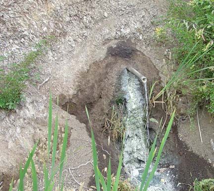
Mileage   Description
0.0       Exit from Highway 101 south onto Highway 25 south toward Hollister. Reset mileage to zero.
          Be cautious at this busy intersection while turning left!

          The Hollister area has experienced extensive development during the housing boom of the 1990s.
          However, numerous farms are still actively providing strawberries, garlic, tomatoes, salad greens, and
          seed nurseries for flowers.
8.5       Traffic light at intersection of Route 156.
9.0       STOP 1 (rolling stop) - Pressure ridges along the Calaveras Fault (see stop description below).

          The landscape features seen here are best viewed by slowly driving from this point onward into
          Hollister. However, be cautious of traffic behind you! A small, dirt section -boundary road on the right
          offers a photo stop, however, do not attempt to stop if farm vehicles are present, or if the ground is
          wet. Keep out where posted and do not walk in crop fields.
11.0      A water tank on the right is built on a pressure ridge along the Calaveras Fault.
11.5      At a stoplight, Highway 25 becomes San Benito Avenue. Continue south into downtown Hollister.
          Prepare to turn right on 6th Street. Proceed west for two blocks to Dunne Park on the corner of 6th
          Street and West Street.
12.3      STOP 2 - Dunne Park (see stop description below). Restrooms are available here. Offset from fault
          creep along the trace of the Calaveras Fault can be observed throughout the neighborhood around the
          park.

          After the stop, proceed east on 6th Street. Reset mileage at corner of 6th Street and San Benito
          Avenue.
0.5       Downtown Hollister.
0.7       San Benito Avenue becomes Nash Road; continue straight at the light following signs to the Hollister
          Hills State Vehicular Recreation Area.
1.6       Turn right (west) at stop sign (Union Road). Cross the bridge over the San Benito River.
1.7       Immediately after crossing the bridge, turn left (south) on Cienega Road.
3.2       Stop sign. Continue to the right on Cienega Road. The road winds uphill through an area affected by
          active landslides in Tertiary sedimentary rocks.
6.5       Cross Bird Creek.
7.0       Turn right at Hollister Hills State Vehicular Recreation Park. The San Andreas Fault runs through the
          valley on the left.
7.1       Pass the park ranger station. A day-use fee per vehicle may be required. Proceed on the unpaved road
          into the park.
7.8       Turn a sharp left and proceed uphill to the picnic tables on the south end of Radio Ridge.
7.9       STOP 3 - Radio Ridge (see stop description below). Restrooms are available at this stop.

          After this stop, return past the ranger station to the park entrance.
8.8       Park entrance. Turn right (south on Cienega Road).
9.9       Vineyard School, on the right, is built on the San Andreas Fault.
10.6      A sag pond along the fault is on the right. A local oral history account is that this pond drained after
          the 1906 earthquake.
10.8      STOP 4 - DeRose Winery (see stop description below). The winery building was built on the San
          Andreas Fault and is slowly being torn apart by ongoing fault creep.

          After the stop, return north toward Hollister on Cienega Road. Reset the mileage to zero.
6.0       Bear left at the "Y" intersection and continue on Cienega Road.
7.5       Turn left (west) onto Union Road.
11.1      Turn left (west) onto Highway 156.
15.2      Turn right onto The Alemeda into the town of San Jan Bautista. The San Juan Bautista Mission is one
          block to the right of The Alameda in downtown. Turn right on Washington Street and start looking for
          parking. There are many excellent restaurants along The Alameda. Field-trip planners might consider
          ample time to enjoy a meal and a tour of the mission area.
15.5      STOP 5 - San Juan Bautista State Historical Park (see stop description below).

                                                    24
STOP 1 (rolling stop) - Pressure Ridges Along the Calaveras Fault Near Hollister

Stop highlights: fault scarps, pressure ridges, and sag ponds along the Calaveras Fault System

    Low linear escarpments reveal the main fault trace of the Calaveras Fault and other splay faults throughout the
Hollister area. Examples of these pressure ridges and fault scarps can be seen along Highway 25 between the intersection
of Highway 152 and downtown Hollister (figs. 1 and 2). (Driving warning: Highway 25 is a busy highway, and it is not
recommended to stop along the road, particularly if more than one vehicle is involved.)

     The Calaveras Fault is part of the greater San Andreas Fault System in the San Francisco Bay region. The Calaveras
Fault splays away from the San Andreas Fault about 10 miles south of Hollister near the town of Paicines, California. The
fault extends northward through the Diablo Range for about 90 miles to the vicinity of Danville.

     The southern segment of the Calaveras Fault (between Paicines and San Felipe Lake along Highway 152) is one of
the fastest creeping fault segments in the San Francisco Bay region. Historic surface measurements show that the fault is
creeping in the range of 11 to 19 mm per year (Kelson and others, 2004). Geophysical investigations show that as much
as 174 kilometers of offset has occurred along the Calaveras Fault in the past 12 million years. This translates to roughly
13.7 mm of offset per year (McLaughlin, and others, 1996). Strike-slip deformation is partitioned between the northern
Calaveras, the Hayward, and other faults that splay from the central segment of the Calaveras Fault in the vicinity of
Calaveras Reservoir.

                                                        Figure 2-2. Escarpment and linear ridge (pressure ridge) on the
                                                        Calaveras Fault along the east side of Highway 25 north of
                                                        downtown Hollister.

                                                        Figure 2-3. A sag pond and low linear scarp along a second strand
                                                        the Calaveras Fault of the west side of Highway 25 north of
                                                        downtown Hollister. This view was taken in the same location as
                                                        the image above.

STOP 2 - Dunne Park, Hollister

Stop highlights: creeping trace of the Calaveras Fault; offset curbs, walls, buildings, and other damaged infrastructure

   The Hollister region experienced damage from both the 1906 and 1989 earthquakes. The town also experienced
minor damage from earthquakes on the Calaveras Fault: the 1979 Coyote Lake earthquake (M = 5.8) and the 1874
Morgan Hill earthquake (M = 6.3).

    The Calaveras Fault runs through the urban heart of Hollister. Dozens of residential homes are built on, or
immediately adjacent to, the active creeping trace of the fault, and damage from fault motion can be traced from block to
block both north and south of Dunne Park. Cracks and offset sidewalks, curbs, walls, and buildings can be seen along
every street and alley.

                                                            25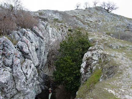
Although local residents are probably accustomed to people observing fault damage, it is extremely important to
warn field trip participants not to walk on lawns, photograph homes or people, and to limit walking to public sidewalks,
alleys, or streets. California laws relating to earthquake damage and repair to existing homes along active faults have put
an extra financial burden on residents along the fault zone; some are quite vocal and deserve respect for their opinions.
All the homes in this neighborhood were built before modern earthquake laws were enacted.

                                                        Figure 2-4. View looking east along an offset wall and sidewalk
                                                        on 6th Street in Hollister adjacent to Dunne Park. The park itself
                                                        preserves a low hill that is a scarp of the Calaveras Fault. The low
                                                        area within the park west of the scarp was partly a sag pond prior
                                                        to development of the area.

STOP 3 - Hollister Hills State Vehicular Recreation Area

Stop highlights: rift valley of the San Andreas Fault, an offset stream, shutter ridges, and vegetation and bedrock
contrasts on opposite sides of the fault

     The Hollister Hills State Vehicular Recreation Area consists of 6,627 acres dedicated to off road vehicle activities.
The north section of the park has over 60 miles of trails for to motorcycles, and the southern section is limited to 4-wheel-
drive vehicles. It is operated by the State Department of Parks and Recreation. An entrance fee is required to use the park
(field trip planners might call in advance to inquire about educational group access waver).

    The park straddles the San Andreas Fault. Radio Ridge is a low linear hill in the middle of the broader linear valley
of Bird Creek. A picnic area on the ridge provides views of the surrounding landscape. The steep, chaparral-covered
slopes on the southwest side of the valley are underlain by crystalline basement rocks (granitic plutonic rocks of
Mesozoic age, and of Paleozoic and Mesozoic gneiss, schist, and marble of the Fremont Peak area that predate the
granitoid intrusions).

     The northeast side of the valley is dominated by oak woodlands and grasslands. The bedrock in this area consists of
late Tertiary (Miocene and Pliocene) sedimentary rocks of marine and non-marine origin. Both fossil shell material and
lignite occur amongst beds of sandstone, shale, and mudrocks mostly of the Pliocene age Etchegoin Formation.

                                                        Figure 2-5. This view is looking east from Radio Ridge to the gap
                                                        where Bird Creek (an fault offset stream) cuts through a shutter
                                                        ridge and drains toward the Hollister valley. Bird Creek follows
                                                        the straight valley of the San Andreas rift.

                                                             26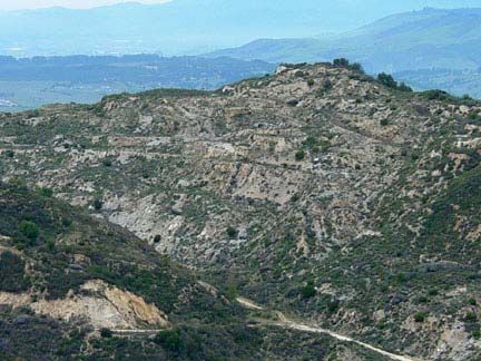
Figure 2-6. This view is looking toward the southeast from Radio
                                                         Ridge up the San Andreas Rift Valley. The active trace of the San
                                                         Andreas Fault runs along the right side of the grassy area in the
                                                         valley.

STOP 4 - DeRose Winery

Stop highlights: offset drainage ditch and building on the San Andreas Fault, sag ponds, San Andreas Rift Valley

    The DeRose Winery claims to be the "oldest existing winery in California." A French immigrant, Theophile Vaché
established a vineyard in Cienega Valley and began selling wine in San Juan Bautista starting in 1854. Cienega means
"marsh" in Spanish and the valley is appropriately named after the natural sag ponds that exist along the San Andreas
Fault in the valley. The vineyard has a long history of wine production and has survived several changes in ownership,
major earthquakes, and the age of prohibition.

     From 1953 to the early 1980s the vineyard was owned and managed by Almaden Vineyards. The company expanded
to produce nearly 3,500 acres of grapes in the area, but later in this period the company changed its production focus, and
most of the vineyards were abandoned.

    The DeRose and Cedolini families, and a business partner, Ernie Miller, purchased the winery in 1988. The families
claim their ancestors have been making wine for over 10 generations. With a modest start using existing vines, the owners
began producing zinfandel, cabernet, and pinot grape wines. Today the vineyard produces about 5,000 cases of wine
annually under the DeRose Vineyards label amongst which include award-winning zinfandel, negrette, cabernet franc and
viognier wines. The vineyard's cellar covers about 4 acres with a capacity of 37,000 fifty-nine gallon barrels.

     The large production facility has an interesting history because it was built directly on the trace of the creeping
section of the San Andreas Fault. Evidence of damage to the building and infrastructure along the trace of the fault are
clearly visible. Perhaps of greatest significance is an offset cement-lined channel that was built in the late 19th century. It
now displays about a meter of right lateral offset. The vineyard building itself is offset by the fault. Cracks in the parking
area, and offset walls and bent boards can be seen on both sides of the building. Wine tasting and a tour of the facility
may be arranged by calling the vineyards in advance. The site is now a national landmark. For more information see:
http://www.derosewine.com/.

                                                            Figure 2-7. This cement-lined drainage ditch on the south side
                                                            of the DeRose Vineyards shows offset from creep along the San
                                                            Andreas Fault. The drain was probably constructed before the
                                                            1906 earthquake.

                                                              27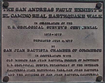
STOP 5 - San Juan Bautista

Stop highlights: escarpment of the San Andreas Fault, a historic Catholic mission damaged by the 1906 earthquake

     The location chosen to build the San Juan Bautista Mission couldn't have been better in the eyes of the Franciscan
fathers when they founded it on June 24, 1797. A low ridge above the broad floodplain of the San Benito River would
provide a commanding view of agricultural activities. In time the mission and settlement would host commerce traffic
along the El Camino Real (the King's Highway) that passed along the base of the hill next to the mission site. This is the
highway that connected all of the California missions, and later served as one of California's major stage and wagon
roads. The town site had great potential to become a significant population center in California. However, many things
happened over the course of time that prevented the town from growing. To begin with, little did they know that the
straight hill next to the mission site was the escarpment of the San Andreas Fault!

                                                          Figure 2-8. The San Juan Bautista Mission. The trace of the San
                                                          Andreas Fault runs along the foot of a historic grandstand
                                                          (painted green) along the "El Camino Real" (at the base of the
                                                          stairs). The historic road runs along the San Andreas Fault scarp
                                                          through the northeast side of town.

     The onset of trouble began before the mission was even built. In October, 1798 the shaking from an earthquake was
so bad that the missionaries slept outside for the whole month. As many as six strong earthquakes occurred in a single
day, leaving many huge cracks in the ground and damaged newly constructed buildings. Shortly afterward, a newly
constructed church building was destroyed by an earthquake in 1803. However, the town population was growing
quickly. The modern mission was designed to accommodate a thousand people and, they hoped, to withstand significant
earthquake shaking. The developing mission experienced its next damaging earthquakes in 1836 and 1838. The 1836
Hayward earthquake may have actually had its epicenter along the San Andreas Fault near San Juan Bautista! The 1838
earthquake occurred along the Peninsula section of the San Andreas Fault.

    In the period before the 1849 Gold Rush, the town of San Juan Bautista had a population of several hundred
Californios (Spanish descendants) and a large Native American population. The San Juan Valley was the home of the
Mutsun Indians. At one time some 1,200 Indians lived and worked at this mission (as many as 5,000 Mutsun Indians are
buried in the town cemetery). The Gold Rush brought a flood of northern European and English-speaking settlers to the
region. However, these new immigrants largely avoided the Spanish-speaking town and established Hollister that would
soon eclipse San Juan Bautista as the economic center of San Benito County. The transition happened on the heals of
disaster.

     In 1869 a smallpox outbreak occurred. A local resident observed that a guest at a San Juan Bautista town meeting had
symptoms of the disease. They immediately tried to quarantine the sick person but it was too late. The entire community
was soon quarantined with Marshall Law rules; if someone attempted to flee they would be shot. When the outbreak was
over, nearly a third of the town's residents were dead, and a community of Native Americans (laborers) nearby was
completely wiped out by the disease. Six month later, a fire swept through much of the downtown area. The combination
of the two event crippled the town for years.

     Then the 1906 earthquake struck. The mission was nearly destroyed along with many of the business buildings and
residents throughout the town.The next crushing blow came when the town was bypassed by the railroad (that went,
instead, through Hollister). In addition, much of the land around could not be developed for fear of flooding of the nearby
San Benito River.

                                                            28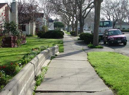
In 1949, the Hearst Foundation financed efforts to restore the mission to its original form. However, repair of damage
to the mission from the 1906 earthquake was not completed until the 1970s. In contrast, the 1989 earthquake only caused
minor damage. However, in many respects the historic town has been "saved" by its misfortune. Today the town retains
much of its historic architecture, culture, and charm. It has a thriving restaurant and shopping district on The Alemeda
(3rd Street), and the active historic Catholic mission and museum area on 2nd Street are part of the San Juan Bautista
State Historical Park.

                                                           Figure 2-9. A brass plate on the San Juan Bautista Mission
                                                           grounds commemorates the 100th anniversary of the U.S.
                                                           Geological Survey. The original exhibit contained a USGS
                                                           seismograph and seven stops along the "El Camino Real
                                                           Earthquake Walk." Only this brass plaque remains today.

     A trip to the mission plaza and grounds offers an excellent view of the San Andreas Fault escarpment along the
northeast side of the mission. Modern offset on the fault can be seen in several locations. A white fence probably
constructed in the early 1970s on either side of El Camino Real at the foot of the stairs near the mission is offset by about
3 inches (either due to ongoing creep along the fault or to poor alignment of the fence!). In addition, a visible break in a
wall can be seen outside of the Faultline Restaurant just southeast of the mission.

Sources: http://missions.bgmm.com/bautista and http://www.sanjuanbautista.com/history.html.

Trip to Fremont Peak State Park (Optional Trip Extension)
Mileage            Description
0.0                At the intersection of The Alameda (in San Juan Bautista) and Highway 156, proceed south on San
                   Juan Canyon Road following signs to Fremont Peak State Park. (The Alameda becomes San Juan
                   Canyon Road south of the intersection.). The drive is about 11 miles. Reset trip mileage to zero at the
                   intersection of Highway 156 and San Juan Canyon Road (The Alemeda in San Juan Bautista).
0.2                Bear to the left to stay on San Juan Canyon Road. The road to the right is the Old Stage Road that
                   connects San Juan Bautista to Salinas Valley. A sign at the intersection state that the distance to
                   Fremont Peak is 11 miles.

                   Large barren outcrops of marine sandstone of Miocene age (Temblor Sandstone) crop out in the hills
                   on both sides of the road. Pyroclastic volcanic rocks of Miocene age are mapped in the area but are not
                   visible along the road.
5.0                A private picnic area owned by the Church of Jesus Christ of Later Day Saints (Mormon) is on the
                   right. The picnic area is adjacent to a large abandoned "granite" quarry in the Salinian basement
                   complex. Tailing from the quarry operations can be seen near the mouth of San Juan Canyon.
7.0                The road begins to ascend from San Juan Canyon. It passes very close to the San Andreas Fault Zone
                   near the eastern-most point along the route, but nothing is apparent in the forested landscape except
                   perhaps the character of the low divide to the left of the road where the fault crosses a saddle between
                   drainage divides. Bird Creek drainage is to the south.
8.5                STOP 6 - Overlooks along San Juan Canyon Road (see stop description below).

                   Several small pull offs are available along both sides of the road. The road ascends along a ridgeline
                   that provides views of Bird Creek Valley to the east and Peak Canyon (with the Mormon camp quarry)

                                                             29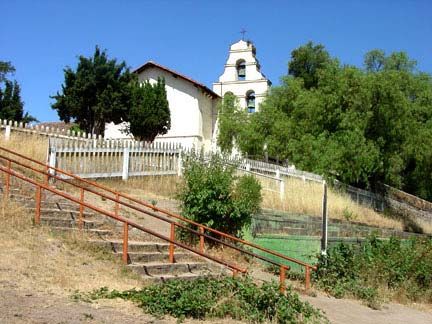
to the west.

                    After the stop continue uphill (west).
11.2                Fremont Peak State Park (see stop description below). Restrooms and camping are available here.
                    Camp sites must be reserved in advance of the trip.

                    After the stop, return to San Juan Bautista by the same route.

STOP 6 - San Juan Canyon Road

Stop Highlights: Views of the rift valley of the San Andreas Fault, weathered granite, an abandoned granite quarry

     San Juan Canyon Road runs south from downtown San Juan Bautista (across from where The Alameda intersects
Highway 156). The road follows the historic stage route for a short distance before veering off to the left. At one time this
area was the historic Indian village where over a thousand people may have lived. That village vanished after a smallpox
outbreak in 1869 that completely annihilated the population. No obvious trace of the Indian village remains.

     San Juan Canyon Road extends for 11 miles to near the summit of Gavilan Peak (now Fremont Peak in Fremont Peak
State Park). The name, Gavilan, has been relegated to the entire range extending south from the San Juan Bautista area to
the Pinnacles to the south. Most of the range is a great massif of Salinian crystalline basement (Mesozoic age granitic
rocks that have intruded older Paleozoic and Mesozoic metamorphic rocks). The Gavilan Range (also spelled Gabilan) is
on the west side of the San Andreas Fault.

    Near where the road enters San Juan Canyon, piles of abandoned gravel in the fields to the right side of the road are
reminders of past mining activity in the area. Salinian granitic rocks and marble were mined locally for aggregate and
probably cement. A large abandoned quarry is in the vicinity of a Mormon camp along the road. It is in the vicinity of the
Mormon camp where the road crosses the Vergeles Fault. The fault splays from the San Andreas Fault near where San
Juan Canyon road makes a steep bend to the south and ascends from the valley along a ridgeline leading to Fremont Peak.
The Vergeles Fault extends westward across the northern flank of the Gavilan Range and vanishes under the cover of
Quaternary sediments along the Pajaro River Valley to the west of Highway 101.

     While driving up San Juan Canyon Road the bedrock and vegetation changes as it crosses the Vergeles Fault. North
of the fault the bedrock consists of Miocene-age volcanic rocks (not exposed due to weathering and plant cover) and older
Tertiary sedimentary rocks. Massive outcrops of Vaqueros Sandstone (Oligocene age) occur throughout the hillsides
along side of the road. These are the same rocks that crop out along Rocks Road and along Highway 101 south and west
of San Juan Bautista (and at Castle Rock State Park in the Santa Cruz Mountains). In this section of the canyon, the
hillsides are covered with a mixed oak and evergreen forest. On the south side of the Vergeles Fault the bedrock consists
of weathered granitic rocks that are dominantly covered with chaparral on the upland south- and west-facing slopes.

     Stop 6 is located along the road approximately 8.5 miles from Highway 156 on San Juan Canyon Road. Vehicles can
pull off on the right side of the road onto two unpaved spur roads. Vistas are seen on both sides of the road in this area
where the road follows the ridge line. On the west side of the road the view encompasses the abandoned quarry near the
Mormon picnic area and the region around the southern Santa Cruz Mountains in the distance. This hard rock quarry
produced granitic aggregate and stone. The dominant rock type included granodiorite, and garnet-bearing granitoid gneiss
and schist. On the south side of the road the view encompasses the headwater region of Bird Creek in the Hollister Hills
State Vehicular Recreation Area. The trace of the San Andreas Fault can be seen down the valley where the vegetation
changes from chaparral (covering weathered granitic bedrock) to oak woodlands and grasslands growing on latest
Tertiary-age sedimentary rocks on the east side of the fault. The trace of the fault extends into a rift valley southward into
the Cienega Valley region.

     Continue uphill; note the character of the weathered granitic bedrock and the light-colored quartz and aplite veins
that protrude from the weathered rock. Also note the vegetation change where the road crosses from bedrock consisting of
weathered granite to bedrock dominated by marble and other ancient metamorphic rocks.

                                                             30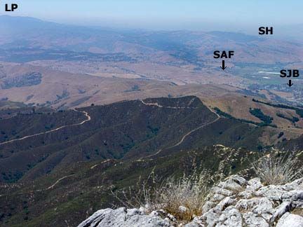
Figure 2-10. View of the San Andreas Rift Valley in the
                                                          vicinity of Bird Creek in the Hollister Hills State Vehicular
                                                          Recreational Area. SAF is the San Andreas Fault. BC is the
                                                          offset gap of Bird Creek Canyon. CF is the San Benito River
                                                          valley and the location of the Calaveras Fault. DR indicates the
                                                          Diablo Range in the southern of Quien Sabe Range southeast of
                                                          Hollister.

                                                          Figure 2-11. An abandoned granite quarry near the Mormon
                                                          camp on San Juan Canyon Road. The rock is mostly granitoid
                                                          gneiss with some schist and intrusive dikes.

STOP 7 - Fremont Peak State Park

Stop highlights: Vistas of Salinas and Santa Clara valleys, Monterey Bay, Salinian Basement marble, lead mines

     In 1846, Captain John C. Fremont and his company of U.S. "surveyors" climbed Gavilan Peak and built a hasty
fortification of earth and logs, expecting stiff resistance from Mexican Californios. The peak area was known for its wide
view of the region and small-scale lead mining activity. Fremont and his men had been allowed to spend the winter in
California under the condition that they stay away from coastal settlements in the region. Fremont chose to ignore this
decree, and reports reached the Mexican California governor, Jose Maria Castro, who was already concerned by the flood
of non-Spanish speaking people into the region. The governor sent troops to remove Fremont and his men. While waiting
for the arrival of troops, the defenders raised the United States flag over their fortification (the first time recorded in
California). However, after several days of "not-so-diplomatic" negotiation, a battle still did not materialize. Probably
more because of their limited supplies of food and water, Fremont and his men grudgingly decided to break camp and
head for Oregon.

     Today, Gavilan Peak is called Fremont Peak and the summit area is incorporated into Fremont Peak State Park. The
name, Gavilan, is now applied to the range extending from about Highway 101 southward to the Pinacles National
Monument area. Trails lead to the craggy summit of the mountain, and the park maintains a public campground (make
reservations well in advance!). A radio facility is operated on one of the lesser peaks in the summit area. Also, the
Fremont Peak Observatory Association maintains an observatory in the park. Many amateur astronomers come to the
peak on the new moon each month.

     Fremont Peak offers some interesting geologic observations. The summit area consists of a ridge of marble and
dolomite that display interesting textural characteristics which are a source of long-standing discussions. The primary
questions focus on whether the texture of the marble is a result of primary sedimentary structures or of secondary
metamorphic foliation. Early investigations suggested that the marble preserves calcitic crinoid column fragments of
Paleozoic age. Other reports suggested that the rock is of Cretaceous age (closer to the age it underwent metamorphic
alteration and intrusion). The rock was ultimately derived from the southern California region where both Paleozoic
carbonate rocks and Mesozoic intrusive rocks occur. The rock migrated northward along the San Andreas Fault and
possibly other fault systems that predate the San Andreas. Fissures in the marble around the ridge top preserve cavernous
travertine deposits and some cerussite (lead carbonate) deposits that were the target of early, small-scale mining
operations. Prospect pits, shafts, and tunnels are scattered throughout the mountain top (mostly on nearby private land). It

                                                            31
is recommended to stay out of the mines due to their instability, and the potential of disturbing bats, rattlesnakes, and
other varmints that access them.

                                                           Figure 2-12. Fremont Peak is 3,169 feet in elevation. This
                                                           north-facing view shows part of a marble outcrop in the
                                                           foreground. The chaparral ecosystem in the midground overlies
                                                           weathered granitic basement. The grasslands behind cover
                                                           Tertiary sedimentary and volcanic rock north of the Vergeles
                                                           Fault. SJB is San Juan Bautista SAF shows the linear
                                                           escarpment of the San Andreas Fault. SH show the Sargent
                                                           Hills. LP is Loma Prieta Peak where the San Andreas Fault
                                                           crosses its southern (left) flank.

                                                           Figure 2-13. An old lead mine in the marble of Fremont Peak.
                                                           Note that the barren bushes in and around the mine are poison
                                                           oak.

Trip to the Anzar Road and Pajaro Gap (Optional Field Trip Extension)
Mileage            Description
0.0                This trip begins at San Juan Bautista Mission. Follow 2nd Street west from the mission.
0.4                Bear right on Monterey (proceed one block).
0.5                Bear left on San Juan Road.

                   The escarpment of the San Andreas Fault vanishes in the fields northwest of the mission, but emerges
                   again along the low hills on the west side of San Juan Road.
2.4                Turn left on Anzar Road. The hill slope on the left side of the road is probably a fault scarp within
                   system of local faults associated with the San Andreas Fault Zone.
3.6                Overpass of Highway 101.
3.7                Intersection of Anzar Road and Searles Road (frontage road for Highway 101). Continue straight on
                   Anzar Road.

                   Note: To get to Stop A from Highway 101, exit at Highway 129 (toward Watsonville. (This exit is
                   40.9 miles south of the intersection of Highway 85 and Highway 101 in south San Jose.) Once off the
                   highway ramp, proceed south on Searles Road. (Searles Road runs parallel to Highway 101 south).
                   Proceed south on Searles Road 0.7 miles to the intersection with Anzar Road. Turn right (west) on
                   Anzar Road. Cracks in Searles Road located several hundred feet south of the intersection with Anzar
                   Road are probably a result of fault creep along the San Andreas Fault.

                   Reset mileage to zero at the intersection of Searles and Anzar roads. Begin rolling Stop A here.
0.0                STOP A - Anzar Road (rolling stop)

                                                             32
0.5 A sign along Anzar Road says:
Stevens Creek Quarry, Williams Pit: (408)253-2512; Plant #2 - (831)623-9555
1.1 Cross Canyon Road. Note the forested, cliffy slope on the left side of the fault and the grass-covered
slope on the right. Cattails mark the location of springs and sag ponds along the fault zone.
1.5 A small abandoned quarry on the left.
1.9 Anzar Lake is on the left. This is one of the largest sag ponds on the San Andreas Fault in the region.
The east side of the rift valley is forested with eucalyptus.
2.4 Forest Road on right. The road bends to the left (south) and ascends a hill into the eucalyptus grove
along the west side of the San Andreas rift zone. The landscape in this region is underlain by Pliocene
marine sediments and Quaternary alluvial (non-marine) sediments. These sediments overly the granitic
basement rocks.
2.8 The road crosses a large conveyor belt that carries crushed rock from the granite quarry to the
processing plant and railroad terminal.
3.1 Cole Road to left; bear to the right.
3.5 Intersection of Anzar Road with Carr Avenue and Aromitas Road. (Aromitas is an unpaved shortcut to
Stop B). However, continue west on Carr Avenue. The road crosses a low divide and descends into the
village of Aromas.
5.2 Turn right onto Carpenteria Road.
5.4 Intersection of Carpenteria and Blohm Avenue. Continue straight on Carpenteria. (Gas and food can
be purchased in the small "downtown" area at the crossroads).
5.6 Turn right on Quarry Road just before the railroad tracks.
6.1 Intersection of Aromitas Road and Quarry Road. Proceed north into the quarry.
6.4 Stop B - Aromas Granite Quarry (see description below). Stop at the quarry entrance station before
proceeding. Permission is required to enter the quarry, and mining activity may prevent access to the
main pit. It is advisable to call for tour permission well in advance.
After the stop, return to the intersection of Quarry Road and Carpenteria. Turn right (north) on
Carpenteria and proceed across the railroad tracks. Reset the mileage to zero.
0.6 Turn right (east) on Highway 129. Highway 129 follows the valley of the Pajaro River.
1.4 STOP C - San Andreas Fault at Pajaro Gap (rolling stop) (see stop description below).
Please note! Due to fast and heavy traffic on Highway 129, groups should not plan to stop at the bend
in the road where the fault crosses the road. Rather, proceed to a small pull off on the right near the
Crittenden Railroad Bridge.
1.8 STOP C (continued) - Crittenden Railroad Bridge (see stop description below).
An unpaved road on the right leads to a small parking area next to the Crittenden Railroad Bridge over
the Pajaro River. The original railroad bridge was heavily damaged by the 1906 earthquake.
Please Note! Do not attempt to walk on the bridge or the railroad tracks! Trains blaze through this
area at high speeds and the sound of their approach may be muffled by highway noise.
After the stop, continue east on Highway 129.
4.3 Intersection of Highway 129 and Highway 101 and Searles Road. End of field trip.
STOP A (rolling stop) - San Andreas Fault Along Anzar Road
Stop highlights: Fault scarp along the San Andreas Fault, bedrock and vegetation contrasts, sag ponds
Anzar Road follows the San Andreas Rift Valley and provides views of some exceptional geomorphic features. The
granitic basement rock exposed on the west side of the rift valley forms a steep escarpment covered with mixed oak and
evergreen forests. Late Tertiary and Quaternary sediments on the east side of the fault are covered in grasslands. Sag
ponds are common along this quiet rural road; Anzar Lake near the northeast end of the valley is particularly impressive.
West of Anzar Lake the road ascends out of the rift valley through a scenic eucalyptus forest. There are no parking spaces
33along this road, but ample visibility along the straight valley and the general lack of rural traffic shouldn't make stopping
a concern for a picture break.
Figure 2-14. Anzar Lake is a large sag pond in the San Andreas
Rift Valley along Anzar Road.
STOP B - Aromas Quarry
Stop highlights: Salinian basement complex, granodiorite, the Logan Gabbro, active granite quarry operations
The Aromas "Granite" Quarry area is a popular destination for field trips. Advanced access arrangements, hard hats,
and boots are required to tour the quarry (access is forbidden during blasting and heavy mining activity). There is no true
granite being mined in the quarry. The Jurassic age rock consists of coarse crystalline gabbro and diorite (crystals of light-
colored plagioclase feldspar and dark-colored clinopyroxene, hornblende, and amphibole give the rock a "salt and pepper"
texture). Veins of some granodiorite and granitoid rock are also present. (The older Logan Quarry is just over the hill and
is known for its gabbro; the local outcrop belt of this crystalline bedrock is called the Logan Gabbro). The rock is blasted,
crushed, and sorted for use as aggregate and can be found in construction sites and rail lines throughout the region. A thin
cover of Pliocene marine fossil-bearing sediments can be seen unconformably overlying the high walls of the quarry.
The Logan Gabbro has been correlated with equivalent exposures of gabbroic rocks at Gold Hill (south of Parkfield)
and Eagles Rest Peak in the Tehachapi Mountains in Southern California (an offset distance of about 320 kilometers
along the San Andreas Fault).
Figure 2.15. The main active pit at the Aromas "Granite"
Quarry.
STOP C - The San Andreas Fault at Pajaro Gap and Chittenden Bridge
Stop highlights: San Andreas Fault, bedrock and vegetation contrasts, Santa Cruz Mudstone, riparian habitat, springs
Please note: This stop is not recommended for groups of more than a few people because of the dangerous
traffic on the road. Groups should proceed to "STOP C (continued)" described below for a safer and more casual
examination of the area. However, if you do stop please pull off to the right beyond the guard rail, and pull ahead as far as
possible to leave ample room and time for northbound drivers to see cars parked alongside the highway. Please note that
34as on all roadside stops, group leaders or individuals standing along this busy highway could be cited if proper precaution
in not taken to ensure public safety.
Pajaro Gap is the narrow river passage between the southern Santa Clara Valley and the Monterey-Santa Cruz coastal
plain region. The passage defines the southern end of the Santa Cruz Mountains. The Gavilan Range is to the south and
east. The Pajaro River is usually a small spring-fed stream except during infrequent winter floods. Most of its headwater
tributaries have been modified or diverted to support agricultural activities, groundwater recharge, municipal uses, and
flood control. The river is the main drainage of the southern Santa Clara Valley and a large portion of the central Diablo
Range. Its main tributary is the San Benito River that drains the San Andreas Rift Valley south of San Juan Bautista. West
of the gap the river flows to Monterey Bay through the Pajaro Valley, the agricultural region around Watsonville.
Figure 2-16. The San Andreas Fault is poorly exposed crosses
Highway 129. Landslides and plants have covered the fault zone
(near the bend-in-road sign). The outcrop directly behind the car
is weathered granitic rock; the outcrop on the right side of the
image is sheared and weathered Miocene marine mudrocks
(Santa Cruz Mudstone).
Figure 2-17. Beds of Santa Cruz Mudstone are gently dipping
to the northeast towards Santa Clara Valley.
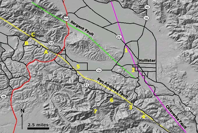
Figure 2-18. A drain pipe in the Santa Cruz Mudstone near the
fault zone is a source of sulfur-rich water. Sulfur and mineral
springs are common along faults throughout the region.
Warning! Do not attempt to have field trip participants cross
the road to examine the springs or outcrops. There isn't enough
room to stand next to the road. Rather, a single individual might
carefully cross the road and fill a water jug. However, the
rotten-egg smelling water is not safe to drink. Cattails grow in
abundance near the springs.
STOP C (continued)
A small access road to the Crittenden Railroad Bridge is about 0.4 mile north of where the San Andreas Fault crosses
Highway 129. This is a much safer place to park and observe aspects of the landscape around Pajaro Gap. However, be
35cautious of broken glass and other material abandoned here. A good overlook view is next to the railroad bridge
(WARNING! Do not walk on the rails or the bridge; it is both unsafe and illegal. Trains can pass through this area at
unexpected high speed and their approach can be masked by highway noise.)
The trace of the San Andreas Fault is revealed on the hillside above Pajaro Gap by both a change in vegetation and a
change in slope. Older "granite" quarry operations are visible on the east side of the river south of the railroad bridge. An
outcrop of Santa Cruz Mudstone next to the bridge parking area is a much safer place to examine the rock than along the
highway.
Figure 2-19. Mt. Pajaro is to the right (elevation 1,578 feet). A
eucalyptus forest grows on the west side of the San Andreas
Fault on the weathered granitic bedrock. Chaparral dominates
the steep hillsides east of the fault where the soil is composed of
weathered Tertiary sedimentary rocks. A riparian forest
community dominates the narrow floodplain of the Pajaro River.
Figure 2-20. The original railroad bridge over the Pajaro River
was heavily damaged by the 1906 earthquake. The bridge
straddles a strand of the San Andreas Fault, which caused minor
rotational offset of the bridge during the 1906 earthquake. The
area also experienced heavy shaking during the 1989
earthquake. Piles of gravel from the Logan Quarry are in the
distance.
Selected References
Harden, D., Stenner, H. M,, and Blatz, I., 2001, The Calaveras and San Andreas Faults In and Around Hollister: In
Geology and Natural History of the San Francisco Bay Area [National Association of Geology Teachers annual field trip
guidebook]: U.S. Geological Survey Bulletin 2188, p. 145-154. On-line at: http://geopubs.wr.usgs.gov/bulletin/b2188/.
Kelson, K.I., Baldwin, J.N., and Randolph, C.E., 2004, Paleoseismic assessment of the central Calaveras Fault, Southern
Santa Clara County, California: U.S. Geological Survey External Research Award no. 1434-HQ-97-G-03151:
http://erp-web.er.usgs.gov/reports/annsum/vol39/nc/G3151.htm.
McLaughlin, R.J., Sliter, W.V., Sorg, D.H., Russell, P.C., Sarna-Wojcicki, A.M., 1996, Large-scale right-slip
displacement on the East San Francisco Bay region fault system, California; implications for location of late Miocene to
Pliocene Pacific Plate boundary: Tectonics, vol.15, no.1, pp.1-18.
Wagner, D.L., Green, H.G., Sausedo, G.J., and Pridmore, C.L., 2002, Geologic map of the Monterey 30'x60' Quadrangle
and adjacent areas, California: California Geological Survey; scale 100,000.
36You can also read