NORTH SPRINGBANK GATE - Conceptual Scheme
←
→
Page content transcription
If your browser does not render page correctly, please read the page content below
NORTH SPRINGBANK GATE
Conceptual Scheme
FEBRUARY 2014
                                             DRAFT

                Submitted by: Brown & Associates Planning Group
Table of Contents
1.0 Introduction. . . . . . . . . . . . . . . . . . . . . . . . . . . . . . . . . . . . . . . . . . . . . . . . . . . . . . . . . . . . . 1
      1.1 Background Studies                                                                                                               2
      1.2 Conceptual Scheme Purpose & Scope                                                                                                2
      1.3 Site History                                                                                                                     2

2.0 Project Area & Description. . . . . . . . . . . . . . . . . . . . . . . . . . . . . . . . . . . . . . . . . . . . 3
      2.1 Location                                                                                                                         3
      2.2 Ownership                                                                                                                        6
      2.3 Current Land Uses                                                                                                                7
      2.4 Adjacent Land Uses                                                                                                               9
      2.5 Physical Land Features                                                                                                           11

3.0 The Concept. . . . . . . . . . . . . . . . . . . . . . . . . . . . . . . . . . . . . . . . . . . . . . . . . . . . . . . . . . . . . . . 13
      3.1 Policy Influence                                                                                                                 13
      3.2 Design                                                                                                                           14

4.0 Land Use Plan. . . . . . . . . . . . . . . . . . . . . . . . . . . . . . . . . . . . . . . . . . . . . . . . . . . . . . . . . . . . 15
      4.1 Development Concept                                                                                                              15
      4.2 Highway Oriented Business Area                                                                                                   17
      4.3 Local Oriented Business Area                                                                                                     18
      4.4 Open Space & Pathway System                                                                                                      19

5.0 Economics. . . . . . . . . . . . . . . . . . . . . . . . . . . . . . . . . . . . . . . . . . . . . . . . . . . . . . . . . . . . . . . . 21

6.0 Transportation. . . . . . . . . . . . . . . . . . . . . . . . . . . . . . . . . . . . . . . . . . . . . . . . . . . . . . . . . . 23

7.0 Servicing & Utilities. . . . . . . . . . . . . . . . . . . . . . . . . . . . . . . . . . . . . . . . . . . . . . . . . . . . . 25
      7.1 Stormwater Management                                                                                                            25
      7.2 Domestic Water Supply                                                                                                            28
      7.3 Sanitary Servicing                                                                                                               29
      7.4 Shallow Utilities                                                                                                                30
      7.5 Fire Suppression Services                                                                                                        30

8.0 Public Consultation. . . . . . . . . . . . . . . . . . . . . . . . . . . . . . . . . . . . . . . . . . . . . . . . . . . . 31

9.0 Implementation. . . . . . . . . . . . . . . . . . . . . . . . . . . . . . . . . . . . . . . . . . . . . . . . . . . . . . . . . . 32
      9.1 North Springbank Area Structure Plan Amendment                                                                                   32
      9.2 Conceptual Scheme                                                                                                                32
      9.3 Land Use Redesignation                                                                                                           33
      9.4 Master Site Development Plan                                                                                                     33
10.0 Interpretation of the Plan. . . . . . . . . . . . . . . . . . . . . . . . . . . . . . . . . . . . . . . . . . 34
      10.1 Map Interpretation                                                                                                          34
      10.2 Policy interpretation                                                                                                       34

11.0 Policy Review. . . . . . . . . . . . . . . . . . . . . . . . . . . . . . . . . . . . . . . . . . . . . . . . . . . . . . . . . . . . 35
      11.1 Rocky View 2060 - Growth Management Strategy                                                                                35
      11.2 Inter-municipal Development Plan                                                                                            36
      11.3 The Municipal Development Plan (County Plan)                                                                                36
      11.4 North Springbank Area Structure Plan                                                                                        37
      11.5 Economic Development Strategy                                                                                               38
      11.6 Springbank Airport Master Plan                                                                                              39
      11.7 Parks & Open Space Master Plan                                                                                              39
      11.8 Rocky View Amenity Study                                                                                                    40
      11.9 Commercial, office and Industrial Guidelines                                                                                40
      11.10 Summary                                                                                                                    42

12.0 Background & Supporting Studies. . . . . . . . . . . . . . . . . . . . . . . . . . . . . . . . . . . 43
      12.1 Historical Resource Impact Assessment                                                                                       43
      12.2 Phase 1 Environmental Site Assessment (ESA)                                                                                 44
      12.3 Geotechnical Evaluation                                                                                                     44
      12.4 Preliminary Engineering                                                                                                     45
      12.5 Subcatchment Master Drainage Plan                                                                                           46
      12.6 Commercial Market Opportunity & Positioning Study                                                                           47
      12.7 Fiscal Impact Analysis of Conceptual Scheme                                                                                 47
      12.7 Transportation Impact Assessment                                                                                            48

Figures
      1. Conceptual Scheme Location                                                                                                    1
      2. Rocky View County Growth Management Strategy                                                                                  4
      3. County Plan                                                                                                                   5
      4. Ownership                                                                                                                     6
      5. Existing Land Use                                                                                                             8
      6. Context                                                                                                                       10
      7. Development Concept                                                                                                           16
      8. Open Space                                                                                                                    20
      9. Phase One                                                                                                                     22
      10. Net Revenues - One, Five and Ten Years after Build-out                                                                       24
      11. Transportation                                                                                                               28
      12. Stormwater                                                                                                                   30
1.0                   introduction
 This Conceptual Scheme is intended to provide a comprehensive land use plan with
 policy guidance for the future land use redesignation and subdivision of lands legally
 described as NE 33-24-3-W5M in Rocky View County. See Figure 1 - Conceptual Scheme
 Location. The North Springbank Gate Conceptual Scheme covers approximately 57
 hectares and provides a comprehensive planning framework for future development on
 the referred lands. It addresses planning and development issues such as general land
 uses, servicing (stormwater management, water servicing, and sanitary sewers), open
 spaces and trail networks, and transportation provision.

 This Conceptual Scheme is in conjunction with the application for the North Springbank
 Area Structure Plan amendment.

                                                                                                                          Bo
                                                                                                                            w
                                                                                                                                Ri
                                                                                                                                  ve
                                                                                                                                      r

 Figure 1: Conceptual
    Harmony Community Scheme Location                                                                                      Bo
                                                                                                                                w
                                                                                                                                     Ri
                                                                                                                                       ve
                                                                                                                                          r

       Harmony Community
                                                                                                          Range Road 32

                           Springbank
                             Airport
                                                                                               Range Road 32
                                                        Rge Road 33 Rge Road 33

                          Springbank
                            Airport

                      Twp Road 250
                                              North
                                            Springbank
                                             Highway                               Bingham
                                                                                                                                                        City Limits

                                             Business                              Crossing
                                                Area
                     Twp Road 250
                 Highway 1 / Trans Canada     North
                                            Springbank
                                             Highway                               Bingham
                                                                                                                                              City Limits

                                             Calaway
                                             Business                             Commercial
                                                                                   Crossing
                                               Park
                                                Area                                Court
                Highway 1 / Trans Canada
                      Twp Road 245
                                                Elementary
                                                  School
                                             Calaway                              Commercial
                                              Park                                  Court

                     Twp Road 245
                                                Elementary
                                                  School

      Legend:
                Conceptual Scheme Boundary

     Legend:
               Conceptual Scheme Boundary

 1             North Springbank Gate
1.1 Background Studies                                    1.3 Site
There have been a number of background studies
prepared in support of this Conceptual Scheme. These
                                                              History
studies have been submitted as supporting information     Known records of ownership
for both the North Springbank ASP amendment and           for the subject quarter section
the North Springbank Gate Conceptual Scheme,              dates back to 1901, with the
and are summarized in Section 12- Background and          lands in ownership of the
Supporting Studies.                                       Canadian Pacific Railway
                                                          Company. These lands were
                                                          only owned by the CPR
1.2 Conceptual Scheme                                     for one year, when the first
                                                          homesteader, Andrew Wallace,
    Purpose & Scope                                       obtained the title for the
                                                          lands. Over time , the land
The Rocky View Municipal Development Plan                 has changed ownership, but
(County Plan) provides strategic growth direction,        has consistently been used for
overall guidance on land use planning, and service        agricultural purposes.
delivery policy. The County Plan outlines key
planning documents that are required to guide
land use decision-making, and allows Council to
direct applicants to create a Conceptual Scheme. A
Conceptual Scheme is adopted through bylaw and
provides detailed land use direction, subdivision
design, development guidance, and any other elements
identified by Council.

The objective of the North Springbank Gate
Conceptual Scheme is to establish the policies and
guidelines for a comprehensive land use framework
for the NE 33-24-3-W5M quarter section. It will
accommodate future development that is consistent
with the Rocky View County Municipal Development
Plan and the surrounding Highway Business Area. This
plan will guide an amendment to the North Springbank
Area Structure Plan as well as the redesignation of the
plan area.

                      		                                      Conceptual Scheme         2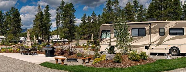
2.0          project Area & Description

2.1 Location
The Conceptual Scheme is           This designation is due to the location along a
located within Rocky View          significant transportation corridor (Highway 1) and
County, approximately 4 km         an established highway interchange at Range Road
west of the City of Calgary, and   33. Current land uses on the southern corners of the
adjacent to the Trans-Canada       interchange provide destination commercial and
Highway 1.                         business services, including Calaway Park (Southwest)
                                   and Commercial Court (Southeast). The recently
The lands are bordered on the      approved Bingham Crossing, located at the Northeast
south by Highway 1, on the east    corner of the interchange, will further establish the
by Range Road 33, and on the       area as a major business and commercial zone,
north by Township Road 250.        providing office, retail, and commercial services.

The subject lands are located      The Springbank Airport, located just northwest of
in a Major Business Corridor       the Conceptual Scheme, is a key reason for future
outlined by the Rocky              non-residential development on adjacent lands.
View County 2060 Growth            With the 2009 adoption of the Springbank Airport
Management Strategy, as well       Master Plan, the airport will see significant expansion
as a Highway Business Area         in terms of intensity of development. Increased air
identified in the Municipal        traffic and aviation uses will increase the requirements
Development Plan (County           for additional commercial services in order to meet
Plan). See Figure 2 - Rocky        the needs of airport users and employees. These
View County Growth                 additional services will also offer increased local
Management Strategy and            employment opportunities and serve to enhance the
Figure 3 - County Plan Map.        overall profile and viability of the Highway Business
                                   Area.

3      North Springbank Highway Business Area
Figure 2: Rocky View County growth management strategy

Proposed Conceptual Scheme
located in the "Major Business
    Corridor" of the Growth
    Management Strategy

                                                                     Figure 4
                                  Rocky View County Growth Management Strategy
                                                                        August 2013
                                 		                     Conceptual Scheme        4
figure 3: county plan map

                  Proposed Conceptual
                 Scheme located in the
                "Highway Business Area"
                   of the County Plan

                                                         Figure 5
                                              Proposed County Plan
                                                           August 2013

5    North Springbank Highway Business Area
2.2 Ownership
The subject quarter section has been subdivided into three parcels: a lot proposed for
development of Woody’s RV World, a lot designated for Edge School, and the balance
of the quarter section remaining in ownership of Mr. and Mrs Gordon Smith (Figure 4 -
Ownership map).

figure 4: ownership map
        Springbank
          Airport

       Springbank                                                Twp Road 250
         Airport

                                                                    The Edge
                                                               School for Athletes
                                                                Twp Road 250
                                                                     Society
                                                          (7.89ha/19.5acs)      (5.29ha/13.08acs)

                                                                   The Edge
                                                               School for Athletes

                                                                                                     Rge Road 33
                                                                    Society
                                                         (7.89ha/19.5acs)       (5.29ha/13.08acs)                       Bingham
                                                                                                                        Crossing
                            Mr. & Mrs. Gordon Smith                          Woody's RV
                                                                                                    Rge Road 33

                                   (35.1ha/86.7acs)                              World
                                                                              (6.1ha/15ac)
                                                                                                                        Bingham
                                                                                                                        Crossing
                           Mr. & Mrs. Gordon Smith                           Woody's RV
                                  (35.1ha/86.7acs)                               World
                                                                              (6.1ha/15ac)

                                     Highway 1 / Transcanada

                                           Calaway Park                                                              Commercial Court
                                    Highway 1 / Transcanada

                                          Calaway Park                                                               Commercial Court

   Legend:
             Conceptual Scheme Boundary

                                                                                                                         Figure 2
  Legend:
                                                                                                                   Ownership Map
            Conceptual Scheme Boundary
                                                                                                                           February 2014

                                   		                                                               Conceptual Scheme                      6
                                                                                                                        Figure 2
                                                                                                                   Ownership Map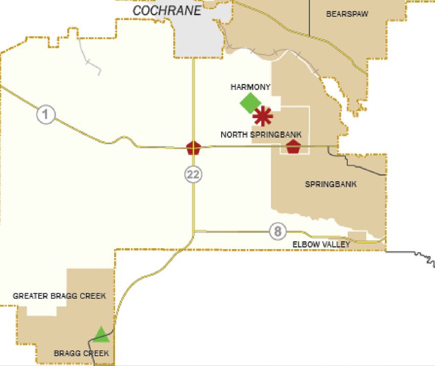
2.3 Current Land Uses
The plan area includes one quarter section containing two land use designations. The
Public Services district in the northeast corner of the quarter contains the Edge School.
The remaining lands are designated as Ranch and Farm District and are currently used
for agricultural purposes (Figure 5 - Existing Land Use Map).

7      North Springbank Highway Business Area
figure 5: Existing land use map

                                                  4                                                  3

 All lands are designated RF (Ranch and Farm District) unless noted otherwise
 Airport District                      AP                         Residential Two District           R2
 Storage and Sales Industrial District I-IS                       Residentail Three District         R3
 General Business Districs             B-2                        Farmstead District                 F
 Recreational Business District        B-4                        Public Service District            PS
 Agricultural Business District        B-5                        Ranch and Farm Two District        RF-2
 Agricultural Holding District         AH                         Direct Control District            DC

         North Springbank Highway Business Area

                                                                                                         Figure 3
                                                                                                Existing Land Use
                                                                                                            February 2014

                                		                                                     Conceptual Scheme                    8
2.4 Adjacent Northwest
Springbank Airport consists of a wide range of
Land Uses commercial uses, including flight training, indoor and
outdoor storage, warehousing, offices, and a restaurant.
Associated with the Airport are the Noise Exposure
The majority of land adjacent
Factor (NEF) contours that extend beyond the Airport
to the North Springbank Gate
lands. While they do not directly affect the Conceptual
Conceptual Scheme is currently
Scheme area, lands to the south and east of the airport
used for non-residential
are impacted, affecting the type of future development
purposes. There has been a
that may be appropriate. See Figure 6 - Context Map.
gradual increase in commercial
development on the lands
West
adjacent to the subject site.
Lands to the west of the quarter section are currently
The existing and planned
used for agricultural purposes.
commercial projects along
Range Road 33 at Highway South
1 are creating a commercial Calaway Park, the largest outdoor theme park in
destination at this strategic western Canada, is located directly south and across
intersection. Highway 1. The theme park acts as a regional draw to
the area. Also designated on the quarter section is
North
DC20, which is intended to facilitate the development
Adjacent lands to the north
of a Factory Outlet Shopping Centre comprised of
include a church (DC27) and
stores that are predominantly owned or occupied by
country residences (R-2).
product manufacturers or their licensed agents.
The General Business District
(B-2) allows for a wide range Southeast
of businesses and associated The Springbank Court Commercial District is a business
uses. The Recreation Business park with commercial development intended to
District (B-4) allows for a wide provide services to the travelling public, tourists, and
range of recreational business the local Springbank community.
uses.
East
The Storage and Sales The two quarter sections directly to the east of
Industrial District (I-IS) the Conceptual Scheme will contain the Bingham
accommodates outdoor Crossing development. The overall project will
storage of vehicles and include a shopping destination and lifestyle centre,
equipment including RV’s, providing office, retail, and commercial services. Phase
trailers, farming implements, 1 of Bingham Crossing (DC148) has recently been
self-storage and similar approved, consisting of significant retail uses along
businesses where temporary the Highway Edge Zone, a more pedestrian-focused
storage is the primary use. shopping and socializing area, and a seniors housing
community.
9 North Springbank Highway Business Areafigure 6: context map
Bo
w
Ri
ve
r
Range Road 32
25
30 SPRINGBANK
35 AIRPORT
40 35 25
30
Rge Road 33
25
Twp Road 250
City Limits
Highway 1 / Trans Canada
Twp Road 245
Legend:
Conceptual Scheme Boundary NEF-Noise Exposure Contours Highway 1- Range Road 33
Existing and Proposed Interchange
Non-Residential
Figure 3
Context Map
February 2014
Conceptual Scheme 102.5 Physical Land Features The North Springbank Gate Conceptual Scheme area is approximately 57 ha and has a relatively flat topography. The site is part of an undulating regional topography generally sloping in a west by southwest direction. There is a high point in the northern portion of the lands owned by Woody’s RV World. Groundwater flows are generally in a west by south-west direction and the subject quarter section is well drained. The storm detention pond in the southwest corner of the Edge School property is intended to manage surface water run-off from the school property only. Lands to the east and northeast are vacant agricultural lands. Historically, the subject lands and surrounding areas were used for agricultural purposes until the late 1960’s. With commercial development in the area gradually increasing, and development of the Edge School on the subject site, future use of the land for farming or ranching purposes is now impractical. View from Highway 1 - southeast section of the Conceptual Scheme 11 North Springbank Highway Business Area
View of the Conceptual Scheme area from the northeast

View of the stormwater pond in the southwest corner of the Edge School property

                      		                                    Conceptual Scheme     12
3.0 vision
3.1 Policy Business Areas to compliment other businesses,
maximize the use of existing infrastructure, minimize
Influence land use conflicts with agricultural uses and minimize
the amount of traffic being drawn into rural areas.
The subject lands, comprising
The North Springbank Gate Conceptual Scheme is
one quarter section, are
located within a Highway Business Area which is
located at the northwest
intended to take advantage of the Provincial Highway
corner of the intersection of
System. It is:
Highway 1 and Range Road
33. They are legally described • located along an interchange with the Provincial
as the NE-33-24-3-W5M, and Highway Network
form part of the Highway
Business Area, located in North • specifically created to accommodate land uses
Springbank, which is identified consistent with the purpose of a Highway Business
on Map 1– Managing Growth, of Area
the County Plan.
• encompasses a limited development area within
This Conceptual Scheme the northwest quadrant of the interchange
takes its lead from County
Plan Policies 14.2 and 14.3 to • planned in a comprehensive manner
direct business development
to locate in identified Business Given the strategic direction and policy conformance
Areas. The Policies also requirements of the County Plan, the County Plan is
encourage the infilling or a key factor influencing the North Springbank Gate
intensification of existing Conceptual Scheme design.
13 North Springbank Highway Business Area3.2 Design
The Conceptual Scheme is based on the creation of a highway-oriented, outdoor
activity related commercial/retail development. With the strategic location on-route to
Banff, Canmore, and Kananaskis Country, the intention is a development that includes a
strong mix of outdoor oriented retail and supporting commercial uses that cater to the
travelling public and the convenience needs of the local community. Uses could include
apparel, sporting and recreation equipment, healthy lifestyle speciality retail, hospitality,
accomodation, food/beverage functions, and other related services. Commercial, and
hospitality uses will help support and be complimentary to the activities of the Edge
School and Springbank Airport. While the local oriented uses will cater to the surrounding
local community.
The Conceptual Scheme has the opportunity to enhance the lifestyle and sports appeal of
the Springbank community while offering employment opportunities and providing local
and destination commercial and business services.
The North Springbank Gate Conceptual Scheme is based upon the site’s characteristics
within Rocky View and the larger Calgary region:
• the site is strategically located as the commercial and service epicentre for
Springbank
• the site is well positioned to serve local residents, regional commuters, tourists, and
the adjacent Springbank Airport workforce, users and visitors
• the site’s proximity to the Rocky Mountains, the Edge School, and community
recreation facilities provides opportunities for commercial uses that cater to “outdoor
lifestyle” choices
• the site’s “gateway” location lends itself to tourist, food/beverage functions, and hotel
land uses
Taking into account all of the factors listed in this section, the North Springbank Gate
Conceptual Scheme will act as a destination centre for the community and as the regional
stopping point for travellers and outdoor enthusiasts. This combination of development
components will identify this strategic site as a gateway to Springbank and greater
Calgary.
Conceptual Scheme 144.0 Future development concept
4.1
Development
Concept
The Future Development
Concept for the North Land Use Area
Springbank Gate Conceptual
Scheme includes two Business/ Highway Oriented 20.4 ha
Commercial Areas, as shown
on Figure 8 - Development
Local Oriented 13.2 ha
Concept Map. The Highway
Oriented Area comprises the
Open Space 4.5 ha
majority of the business uses
and is located adjacent to
Highway 1 and Range Road 33. Stormwater Ponds 4.1 ha
The remainder of the business
uses will accommodate Local Roadways/Road Widening 4.2 ha
oriented uses and is located
adjacent to Township Road Edge School 7.9 ha
250 and the Edge School.
Open Space and stormwater Totals 57.3 ha
ponds are a component of
the Conceptual Scheme. The
Edge School is an existing use
within the Conceptual Scheme
boundary.
A summary of the land uses
contained in the Conceptual
Scheme and their areas is as
follows:
15 North Springbank Highway Business AreaTwp Road 250
figure 7: DEVELOPMENT CONCEPT map
Edge
School
Twp Road 250
Rge Road 33
Bingham
Crossing
Edge
School
Rge Road 33
Bingham
Crossing
Highway 1 / Trans Canada
Calaway Park
Commercial Court
Highway 1 / Trans Canada
Calaway Park
Commercial Court
Legend:
Conceptual Scheme Boundary Open Space Roadway
Local Oriented Business Stormwater Pond
Highway Oriented Business Edge School
Legend:
Conceptual Scheme Boundary Open Space Roadway
Local Oriented Business Stormwater Pond
Highway Oriented Business Edge School
Conceptual Scheme 164.2 Highway
Oriented
Business
Area
The Highway Oriented area
will allow for development
adjacent to Highway 1
and Range Road 33. The
development will provide
services to the travelling public
and tourists, and includes
business uses that require a
high degree of visibility and
ease of access to a major
transportation route. Uses
could include a combination
of medium to large sized
retailers, offices, restaurants,
services, accommodation,
and automotive and RV
dealerships. The Highway
Business Area is a high profile
business area and represents
a “gateway” development to
Springbank and western Rocky
View County.
17 North Springbank Highway Business Area4.3 Local
Oriented
Business
Area
The Local Oriented area
is located north of the
Highway Business Area,
adjacent to Township Road
250 and the Edge School.
The Local Oriented area
will accommodate small to
medium sized commercial
business that are oriented
towards serving the
Springbank community. The
area will provide a combination
of shops, restaurants, services,
offices, entertainment,
accommodation and
government services.
Conceptual Scheme 184.4 Open Space & Pathway System
The open space and and amenities and provide a more sustainable and
pathway system in North active transportation option.
Springbank Gate will
promote a walkable and Local pathways within the Conceptual Scheme will
interconnected development follow the road network, connecting the various
that complements the commercial uses throughout the site, and providing
overall existing and future access to the open space area.
pathway system of the area. A
Conceptual Bicycle Route will The open space within the North Springbank Gate
be located along the northern Conceptual Scheme is focused around the naturalized
border of the Conceptual stormwater pond in the southern portion of the site.
Scheme parallel to Range The landscape will focus on the natural environment,
Road 250. The route will cross while maintaining appropriate public access for passive
Range Road 33 and connect to recreation use.
Bingham Crossing (Figure 8).
Open Space & Pathway System Policies
This Bicycle Route is identified
in the Parks and Open Space
4.4.1 The Conceptual Bicycle Route along Range
Master Plan. By contributing
Road 250 shall be located in conformance with
to the bikeway route, North
the Parks and Open Space Master Plan and will
Springbank Gate will assist in
be constructed in accordance with Rocky View
connecting the regions’ trails
County’s Servicing Standards.
4.4.2 The Conceptual Bicycle Route shall be
developed in phases that correspond with the
phasing of the development.
4.4.2 The local pathways within the Conceptual
Scheme shall be constructed by the developer,
in accordance with Rocky View County’s
Servicing Standards.
4.4.3 The open space in the south portion of the site
shall be focused on a natural landscape and
will be maintained by the developer for passive
recreational use.
19 North Springbank Highway Business AreaFigure 8: Open Space
Twp Road 250
Connection to
Bingham Crossing
Twp Road 250
Connection to
Bingham Crossing
Edge
School
Edge
School
Bingham
Crossing
Rge33Road 33
Bingham
Crossing
Rge Road
Highway 1 / Transcanada
Highway 1 / Transcanada
Calaway Park Commercial Court
Calaway Park Commercial Court
Legend:
Conceptual Scheme Boundary Open Space
Legend: Stormwater Pond
Conceptual Scheme Boundary Conceptual
Open SpaceBicycle Route
Local Pathway
Figure 8
Stormwater Pond
Conceptual Bicycle Route
Local Pathway Open Space
Figure 8
February 2014
Open Space
February 2014
Conceptual Scheme 204.5 Phasing
North Springbank Gate is anticipated to be developed in phases. Phase One of the
Conceptual Scheme will consist of Woody’s RV World, located on the site currently
owned by the company (Figure 9). Additional phases will be introduced as the
landowner and any future development interest deem appropriate.
PHASING Policies
4.5.1 Phase One of North Springbank Gate should be consistent with Figure 9.
4.5.2 A Master Site Development Plan shall be completed and adopted by the
County for each phase of development within the North Springbank Gate
Conceptual Scheme prior to the approval of a Development Permit or
subdivision application.
21 North Springbank Highway Business AreaTwp Road 250
Figure 9: PHASE 1
Edge
School
Twp Road 250
Bingham
Crossing
Rge Road 33
Edge
School
Bingham
Crossing
Rge Road 33
Highway 1 / Trans Canada
Calaway Park Commercial Co
Highway 1 / Trans Canada
Calaway Park Commercial Court
Legend:
Conceptual Scheme Boundary
Phase One Woody's RV World
Figur
Legend:
Conceptual Scheme Boundary
Phase One Woody's RV World Phasin
February 20
Figure
Phasing
February 2014
Conceptual Scheme 225.0 economics The North Springbank Gate • The total optimal development of the Conceptual Conceptual Scheme will Scheme could contain up to 280,000 s.f. of contain a combination of commercial development, with annual tax revenue commercial uses that provide for Rocky View County ranging from $338,000 to services to the travelling $784,000. public and tourists, as well as the local community. The site • The first phase of development, Woody’s RV possesses the key attributes World, will contain approximately 39,000 s.f. of to appeal to a wide and commercial space and generate approximately significant patronage base $45,000 in annual property tax revenue. including the Greater Calgary population (particularly • The total net revenue gain collected by the County northwest and southwest one year after the development is completely built sectors), tourists, highway is approximately $2.3 million. commuters, Springbank Airport users and employees, and most importantly, local Springbank residents. These uses will have significant economic benefit to Rocky View County through additional tax revenue, spending dollars retained in the County, and the creation of local jobs for Rocky View residents. Based on findings in the Fiscal Impact Analysis by InfraCycle Fiscal Solutions, the Conceptual Scheme is anticipated to have the following fiscal results: 23 North Springbank Highway Business Area
Figure 10: Net Revenues GAIN - One, Five, and Ten Years after Build-Out

              $25,000,000
                                                                                  $23,000,000
              $20,000,000
Net Revenue

              $15,000,000
                                                          $11,500,000
              $10,000,000

               $5,000,000
                                  $2,300,000
                       0
                            One                    Five                     Ten

                                           Years after Build-out

A major contributing factor to the substantial net         strategic location of Highway
revenue gain to Rocky View County is all on-site           1 and Range Road 33. The
infrastructure serving Phase One will be privately         development is consistent with
owned and operated, resulting in no fiscal impact          both the Rocky View 2060-
for on-site infrastructure. The financial impact on        Growth Management Strategy,
community services will be low because commercial          as well as the County Plan, and
uses have low demand for community services.               will create economic benefits
                                                           to the County in the form of
The commercial uses located on this site will generate     non-residential property taxes.
employment opportunities for Rocky View residents,
particularly for the Springbank community.

Overall, the commercial uses in this Conceptual
Scheme support the County’s economic growth
strategy by providing concentrated development at the

                            		                                Conceptual Scheme         24
6.0 Transportation
6.1 Roadways
North Springbank Gate 6.1.1 Internal Road Network
is located adjacent
to a number of major To accomodate Phase One of the Conceptual Scheme, a
transportation routes shared access between Edge School and Woody’s RV World
within Rocky View is located at the the existing Township Road 250- East Edge
County. The site is school access. The intent of the private roadway is to provide
bordered to the south the Woody’s site with a viable access for the foreseeable
by the Trans-Canada future and to facilitate access to the currently undeveloped
Highway, to the east by Edge school lands situated between the proposed roadway
Range Road 33, and to and Range Road 33.
the north by Township
Road 250. Both RR 33 In the short term, no additional improvements, beyond those
and Twp Rd 250 are proposed as part of Bingham Crossing Phase 1, are required
actively used roadways to the overall road network on Township Road 250 or Range
that service the multiple Road 33 to accommodate this condition. If, over time, the
land uses located in the Edge School lands develop, the all-turns access will continue
area. A Traffic Impact to operate at this intersection until congestion dictates a
Assessment (TIA) need for improvement. Any improvements to restrict vehicle
has been prepared movement at the intersection of Township Road 250- East
in support of this Edge School will be funded by the developer.
Conceptual Scheme.
Ultimately, the main access point for North Springbank Gate
Recommendations
will be located at the Mountain View Trail - Township Road
from the TIA provide
250 intersection. At full build- out of the Conceptual Scheme
direction on regional
area, this intersection will be developed as either a dual-lane
road network
roundabout or a signalized intersection
improvements and
internal road sizing.
The main road through the Conceptual Scheme will run
north-south and will intersect with an east-west road that
will connect to Phase One. Internal roadways will increase
connectivity between these two main thoroughfares. The
internal road network is shown in Figure 11.
25 North Springbank Highway Business Area6.1.2 Regional Road Network
The North Springbank Gate Conceptual Scheme is well served by an established network
of regional roads.
Highway 1 is a four lane divided primary highway that has an access point at Range Road
33. Range Road 33 is a north-south paved two lane roadway north of Highway 1 and a
four lane paved roadway south of Highway 1. Township Road 250 is an east-west paved
2-lane rural roadway.
Since the Conceptual Scheme will be developed in phases, the impacts to surrounding
road infrastructure and the need for improvements will vary with time. Additionally, by
2015 Phase 1 of Bingham Crossing is expected to be complete and the resultant road
network upgrades are expected:
• Highway 1/ RR 33 North Junction: This location will be developed as a single
land roundabout
• Highway 1/ RR 33 South Junction: This location will be developed as a dual lane
roundabout located at the ultimate interchange intersection location. The existing
ramps will temporarily remain at their existing locations pending ultimate
reconstruction of the interchange.
• RR 33/ Twp Rd 250: This location will be developed as a single lane roundabout
These 2015 background road network upgrades will accommodate the first phase of
development within the North Springbank Gate Conceptual Scheme, Woody’s RV World.
No further improvements are required beyond the addition of an unsignalized access at
the current East Edge School access off of Township Road 250.
At full build out, the conceptual plan area may include retail, restaurant, grocery, office,
and accommodation uses that will increase peak trips in the area. The site generated
traffic will result in a new access into the site off of Twp Rd 250 and the following
improvements to the surrounding road network would be required:
• RR 33/ Highway 1 North and South Junctions: The intersection will need to be
developed as a full signalized intersection with dual left turn lanes.
• RR 33/ Township Road 250: The intersection will require dual northbound left
turn lanes, dual westbound left turn lanes, and right turn lanes all approaches.
The eastbound Twp 250 to southbound RR 33 movement will need to have a free
movement.
Conceptual Scheme 26• Mountain View Trail/ Twp 250: The intersection will require dual westbound
left turn bays and a continuous free northbound right movement. A two-lane
roundabout is also able to accommodate traffic volumes.
• Bingham Access 2/ Twp 250: The intersection will require a dual lane
roundabout
• Highway 563/ Highway 1 South junction: Requires signalization
The timing of the noted improvement will be determined as development proceeds
in the area. Given the long time frame assessed, up to a 2035 analysis, it will be
appropriate to review the longer term intersection design needs at future stages of
development when the actual rate of background traffic growth can be more accurately
assessed. Road network improvement requirements will be based on updates to
the Transportation Impact Assessment (TIA) submitted with future redesignation,
development permit, or subdivision applications.
ROADWAYS Policies
6.1.2.1 Access to North Springbank Gate shall be generally as shown in the Conceptual
Scheme.
6.1.2.2 All external roads shall be constructed and maintained in accordance with Rocky
View County’s Servicing Standards at the developer’s expense.
6.1.2.3 All roads within North Springbank Gate shall be fully accessible to the public and
shall be designed according to Rocky View standards, with the exception of the East
Edge School- Woody`s RV World access, .
6.1.2.4 The East-Edge School- Woody`s RV World access will be developed as a private
road and all associated costs and maintenance will be developer funded, agreed upon in
an access easement between the two landowners.
6.1.2.5 An update to the TIA shall be provided with all future redesignation applications,
and with each subdivision or development permit application
27 North Springbank Highway Business AreaFigure 11: TRANSPORTATION
View Trail
View Trail
MountainMountain
Twp Road 250
Twp Road 250
Edge
School
Edge
School
Bingham
33 Road 33
Crossing
Bingham
Rge
PHASE Crossing
Rge Road
1
PHASE
1
Highway 1 / Transcanada
Highway 1 / Transcanada
Calaway Park Commercial Court
Calaway Park Commercial Court
Legend:
Conceptual Scheme Boundary
Legend:Internal Road Network
Conceptual Scheme Boundary
Internal Road Network Figure 10
Transportation
Figure
February 10
2014
Transportation
February 2014
Conceptual Scheme 287.0 servicing & Utilities
7.1 Stormwater Management
A Sub Catchment Master The SCMDP area currently drains south-west towards
Drainage Plan has been a culvert crossing the TransCanada Highway. The
undertaken to describe the majority of surface runoff from the existing ground
drainage system for the conditions is overland flow across the site in a north-
Conceptual Scheme area. The east to south-west direction. Edge School currently
drainage system incorporates manages stormwater onsite with a private stormwater
design elements for storm facility, and controls discharge through the existing
runoff capture and enhanced natural drainage course at the south-west edge of their
evaporation and reuse to property. The existing discharge from Edge School will
manage stormwater in a be accommodated by the overland drainage plan for
sustainable manner under the Conceptual Scheme area.
predevelopment volume and
release rate conditions. Stormwater ponds will be used within the Conceptual
Scheme in order to retain the accumulation of
stormwater runoff from the development, while
discharging at a controlled release rate. The volume of
stormwater within the ponds is reduced by strategies
such as:
• Low Impact Development Strategies
• Supplying non-potable water reuse for commercial
application within the development
• Irrigating landscaping and other pervious surfaces
• Wetting of impervious surfaces
The Conceptual Scheme area has been separated into
two catchment areas. Catchment One represents the
first phase of development Catchment Two represents
the remaining Conceptual Scheme area.
29 North Springbank Highway Business AreaFigure 12: Stormwater MAP
Twp Road 250
Twp Road 250
Edge
School
Edge
School
Bingham
Crossing
Rge Road 33Rge Road 33
Bingham
Crossing
Highway 1 / Transcanada
Highway 1 / Transcanada
Calaway Park Commercial Court
Calaway Park Commercial Court
Legend:
Conceptual Scheme Boundary Catchment One
Catchment Two
PUL/PARK
Legend:
Conceptual Scheme Boundary Catchment One
Figure 11
Catchment Two STORMWATER
PUL/PARK February 2014
Figure 11
STORMWATER
February 2014
Conceptual Scheme 30Ultimately, two ponds (in addition to the Edge School stormwater pond) will service the
Conceptual Scheme area, connected through a common Public Utility Lot (PUL).
• Catchment One will have a stormwater pond with an area of approximately 0.53 ha,
located within the first phase of development. Stormwater runoff will be conveyed
to the pond through overland drainage and discharge from the stormwater pond
will flow into the adjacent lands to the west of the parcel. The Phase 1 pond will later
be incorporated into the main stormwater facility, which will service the remainder
of the Conceptual Scheme area.
• Catchment Two will have a stormwater pond approximately 3.7 ha in size, and will
serve the stormwater catchment needs of the entire Conceptual Scheme area. An
overland drainage system will be incorporated into the design of future planning
phases in order to eliminate the necessity for storm sewers, manholes, catchbasins,
etc.
For each phase of development, further detailed stormwater analysis will be required, as
per Rocky View County Servicing Standards.
Stormwater Management Policies
7.1.1 Stormwater ponds shall be used in order to retain and control the accumulation
of stormwater runoff from the development.
7.1.2 Phase 1 shall have a pond on site that manages the stormwater runoff for the
Phase 1 development. Stormwater shall be conveyed to the pond through
overland drainage.
7.1.3 Development after Phase 1 will require the construction of a stormwater facility
that serves the stormwater needs of the remaining Conceptual Scheme area.
7.1.4 The ponds in Catchment 1 and Catchment 2 shall be connected by pipe or surface
connection with controlled outflow.
7.1.5 The volume of stormwater within the ponds should be reduced through LID
strategies, supplying non-potable water reuse for commercial application within
the development, irrigating landscaping and other pervious surfaces, and wetting
of impervious surfaces.
7.1.6 All phases of development will require a stormwater management report as per
Rocky View County Servicing Standards.
31 North Springbank Highway Business Area7.2 Domestic Water Supply
As per Rocky View County policy, the preferred source of potable water is piped water
from a piped supplier. At full build-out of North Springbank Gate, the use of piped water
is a viable option through Calalta Waterworks Ltd system or the Harmony system.
Phase One, Woody’s RV World, is currently in the process of obtaining a water
licence from Calalta Waterworks Ltd, which will provide piped potable water to the
development.
DOMESTIC WATER SUPPLY POLICIES
7.2.1 At full build-out, potable water will be supplied through a piped water system to
the Conceptual Scheme area.
Conceptual Scheme 327.3 Sanitary Servicing
At full build out, the North Springbank Gate Conceptual Scheme will require a connection
to a regional or decentralized system.
Currently there is an absence of regional or decentralized wastewater servicing in the
conceptual scheme area. The first phase of development will rely on the use of a sewage
holding tank with a private on-site pump and haul system until connection to a regional or
decentralized piped system is available. In preparation for future regional piped servicing,
the pump and haul system will be configured with an option to provide for a tie into a
future system without causing significant impact to the site.
sanitary servicing Policies:
7.3.1 The first phase of development shall use a sewage holding tank and pump and haul
system, which is the responsibility of the developer, for sanitary servicing needs
until a connection to a regional or decentralized system becomes available.
7.3.2 The mechanical layout of the Phase 1 pump and haul system shall be configured to
allow for a tie into a future piped system without significant impact to the site.
7.3.3 The remainder of development in the North Springbank Gate Conceptual Scheme
shall connect to a regional or decentralized system.
33 North Springbank Highway Business Area7.4 Shallow Utilities
Shallow Utilities, including natural gas, electricity, power, and telecommunications
infrastructure will be provided by the respective utility companies, at the expense of
the developers. The services will be extended into the Conceptual Scheme area on a
phased basis at the time of development. Shallow utility connections will tie into existing
infrastructure in the area. Detailed design for shallow utilities will occur within the
subdivision and development permit stage for each phase of development in the North
Springbank Gate Conceptual Scheme.
Shallow Utilities will be underground throughout the servicing area and will be located
within easements on private property or within road right-of-way subject to Rocky View
County approval.
Shallow Utility Policies:
7.4.1 All shallow utilities and associated infrastructure will be provided at the expense of
the developers.
7.4.2 Detailed design for shallow utilities will occur within the subdivision/ development
permit stage for each phase of development.
7.5 Fire Suppression Servicing
At the time of development of lands, the developer will be responsible to ensure that
the appropriate number of Fire Hydrants, building sprinkler systems as well as the water
systems with the necessary level of Fire Flow are installed on the lands in accordance
with the requirements of the then current Rocky View County Fire Hydrant Water
Suppression Bylaw, Alberta Fire Code, Alberta Building Code, and the County’s Servicing
Standards.
Fire Suppression Servicing Policies:
7.5.1 The developer is responsible to ensure that the appropriate fire suppression
systems are installed in accordance with the Rocky View County Fire Hydrant
Water Suppression Bylaw, Alberta Fire Code, Alberta Building Code, and the
County’s Servicing Standards.
Conceptual Scheme 348.0 public consultation
The public consultation during
PUBLIC OPEN HOUSE the preparation of the North
Springbank Gate Conceptual
Scheme included one open
Woody’s RV World house, association board
North Springbank
meetings, and individual
dialogue with interested
stakeholders.
Please join
Woody’s
RV World The open house occurred
and their on June 26, 2013 from 5:00-
consultants
to discuss 9:00pm at the Edge School. An
Harmony the proposed advertisement was placed in the
RGE. RD. 33
Community new Woody’s
RGE. RD. 40
RV World Rocky View Weekly newspaper
in North for the 2 weeks prior to the
Springbank
Springbank.
Airport
open house and road-side signs
Two question were located along Range Road
Woody’s and answer
TWP. RD. 250
RV World sessions 33, both north and south of
will be held Highway 1. The purpose of this
Bingham
Crossing
starting at
HWY 1 5:30 pm and open house was to discuss the
7:30 pm. early concepts of the Concept
Calaway Commercial
Park Court
Plan and the vision of Phase 1,
Woody’s RV World, as well as to
obtain feedback from adjacent
Wednesday June 26, 2013
5:00 pm to 9:00 pm neighbours. Approximately
Edge School Library 35 people attended the
33055 Township Road 250 open house. In addition to
comment sheets, the public
For further information please contact Paul Mercer, had the opportunity to contact
B&A Planning Group at 403-692-4535 or pmercer@bapg.ca Brown & Associates to discuss
the project further, leading
to a number of individual
conversations.
35 North Springbank Highway Business Area9.0 implementation
The provisions of the North Springbank Gate Conceptual Scheme will be implemented
through:
• An Amendment to the North Springbank Area Structure Plan
• Adoption of the North Springbank Gate Conceptual Scheme
• Land Use Redesignation to accommodate specific business uses
• A Master Site Development Plan to define the site design and appearance of
individual phases
9.1 North Springbank Area Structure
Plan Amendment
An application to amend the North Sprinbank Area Structure Plan (NSASP) has been
submitted in conjunction with this Conceptual Scheme. The proposed amendment
will alter the Land Use Map to permit non-residential, highway business uses on the
Conceptual Scheme lands.
9.2 Conceptual Scheme
The adoption of this document, the North Springbank Gate Conceptual Scheme, by
Rocky View County Council by bylaw is required. The Conceptual Scheme provides a
comprehensive land use plan and policy guidelines for the subject quarter section.
Conceptual Scheme 369.3 Land Use Redesignation A Land Use Redesignation application is required for each phase of development. An appropriate Land Use District(s) will be determined, outlining the provisions applied to those particular lands. An application for the first phase of development, the Woody’s RV World site, has been prepared. The application proposes the redesignation of the Woody’s RV lands to 9 Direct Control (DC) district. This district will accommodate the specific business uses on the Woody’s RV World site. Any development beyond this first phase will require additional land use applications. 9.4 Master Site Development Plan A Master Site Development Plan (MSDP) will accompany each Land Use Redesignation application on the Conceptual Scheme lands. This non-statutory plan provides design guidance, such as building placement, landscaping, lighting, parking, and architectural treatment, for each phase of development. A MSDP for Phase 1, Woody’s RV World, accompanies the associated Land Use Redesignation application. 37 North Springbank Highway Business Area
10.0             interpretation of the plan

10.1 Map Interpretation
The boundaries or locations of any symbols shown on a figure or map are approximate and
shall be interpreted as such.

10.2 Policy Interpretation
Where “shall” is used in a policy, the policy and the actions it requires are considered
mandatory.

Where “should”, “may”, or “encouraged” are used in a policy, the policy and action are
considered optional, but the general intent is compliance.

                         		                                      Conceptual Scheme         38
11.0 policy review
11.1 Rocky View 2060-Growth
Management Strategy
Completed in 2008, Rocky View 2060 provides a framework that incorporates high-
level and longer-term strategies for managing the municipality’s growth over the
next 50 years. It is designed to direct where and how development would be most
desirable and allow for a more definitive and predictable growth pattern. Taking into
account relevant planning frameworks such as the Provincial Land Use Framework
and the Calgary Regional Partnership’s regional plan, the Growth Management
Strategy proposes a land-use vision for Rocky View that is based on the principles of
sustainability, Smart Growth, and triple-bottom- line decision making. It is intended to
direct more detailed municipal statutory plans and decisions regarding land-use and
development.
As community insight and values indicated, the land-use vision portrayed in the
Growth Management Strategy supports substantial nodal growth and targeted
development in focused areas throughout Rocky view. The Strategy anticipates
expansion of Rocky View’s business community, and with the goal of diversifying the
tax base, expanded highway commercial development is expected in nodes along
strategic highway corridors. Development in these areas is intended to be non-
contiguous and nodal in design, focused around interchanges and highway access
points.
The North Springbank Gate Conceptual Scheme is located within the identified
Highway 1 Major Business Corridor, west of the City of Calgary. Commercial
development along this corridor will support Rocky View’s goal of diversifying the
tax base. The Major Business Corridor has significant locational advantages, including
high visibility, access to regional markets, proximity to Springbank Airport, and the
occurrence of existing and expanding commercial development. By concentrating
development into the focused area of Highway 1 and Range Road 33, fragmentation
of agricultural land is mitigated and a commercial centre at the interchange of Range
Road 33 is established.
39 North Springbank Highway Business Area11.2 Inter-municipal Development Plan
The Rocky View County/City of Calgary Intermunicipal Development Plan (IDP) is
intended to identify areas of mutual interest, minimize land use conflicts across municipal
borders, and provide opportunities for collaboration and communication. The North
Springbank Gate Conceptual Scheme is located within the Notification Zone of the IDP.
The Notification Zone does not require detailed joint planning but it provides The City of
Calgary with the opportunity to comment on land use policies and applications circulated
from Rocky View County.
11.3 The Municipal Development Plan
(County Plan)
The new Rocky View Municipal Development Plan advantage of the provincial
(County Plan) was approved on October 1, 2013 and highway system and should be
includes goals, policies, and actions that provide located in proximity to highway
strategic growth direction, guidance for land use intersections and interchanges.
planning, and service delivery policy for the overall The purpose of a highway
county. business area is to contribute
to the County’s fiscal goals,
One of the relevant MDP goals is: provide destination commercial
and business services, provide
“Increase the County’s business assessment services to the travelling public,
base to support the financial sustainability of the and offer local employment
County’s operations in order to reduce the reliance opportunities.
on the residential tax base.”
By focusing development
in these locations and
encouraging infilling of
Business Development: existing business areas, the
The County Plan identifies a number of business County provides for orderly
areas and development forms which accommodate a growth and economic
variety of businesses, and directs the majority of new efficiencies in the development
commercial and industrial businesses to locate in these of transportation and
identified business areas. infrastructure systems. It
maximizes the use of existing
The North Springbank Gate Conceptual Scheme infrastructure, minimizes land
is located in an identified Highway Business Area. use conflicts with agriculture
Highway Business Areas are intended to take uses, and minimizes the
amount of traffic being drawn
into rural areas.
Conceptual Scheme 4011.4 North Springbank
Area Structure Plan
Adopted in 1999, the North approval of the Bingham Crossing Conceptual Scheme,
Springbank Area Structure now support the concept of commercial development
Plan (NSASP) is a statutory on the North Springbank Gate Conceptual Scheme
plan adopted by Rocky lands. Accompanying this Conceptual Scheme is an
View County. Following the amendment to the NSASP in order to accommodate
provisions of the Municipal business and commercial uses.
Government Act and in
conjunction with the Municipal The NSASP classifies general business land uses
Development Plan, the NSASP (Section 5.7) to include stand-alone commercial
provides planning principles development that may provide goods and services
and a more detailed framework to the local community, the traveling public, or a
for subsequent subdivision, recreational market. The NSASP identifies that several
development or redevelopment parcels of land surrounding the Springbank Airport
of the specified area of land. are designated for future business usage as a result of
The Plan also has the ability to the impact from airport operations. Business land use
be amended since it is unable is also suggested for the area south of the Highway #1
to anticipate and examine and Range Road 33 interchange. The North Springbank
every future impact, cost, or Gate Conceptual Scheme provides a non-residential
benefit. Section 1.4 of the option to an area that is already impacted by both the
NSASP also indicates that Springbank Airport and the TransCanada Highway.
where land use planning issues Existing commercial development on the south side of
arise, policies are in place to the Highway 1-Range Road 33 interchange combined
allow the evaluation of these with continued airport expansion, support the concept
issues. of business development in the Conceptual Scheme
area.
The future land use concept
in the NSASP for the North The North Springbank Gate Conceptual Scheme is
Springbank Gate Conceptual located within the Highway #1 Interface identified
Scheme area defines the in the NSASP. The lands within this area are subject
lands as potential residential to special provisions in order to maintain the safety
(Section 5.4). However, of the traveling public and the functional integrity
recent developments in the of the provincial highway. The Conceptual Scheme
area, including the expansion will respect these policies through the proposed
of the Springbank Airport transportation network and appropriate setbacks and
(Springbank Airport Master landscaping adjacent to the highway.
Plan 2009-2029) and the
41 North Springbank Highway Business Area11.5 Economic Development Strategy
Updated in 2003, the Economic Development Strategy is a general reference document
that is meant to guide and facilitate growth. The purpose includes identifying and
summarizing how efforts of the entire Rocky View County will be directed to meet long-
term economic development goals and objectives.
Relevant to the North Springbank Gate Conceptual Scheme, the Springbank Airport and
surrounding areas is identified as a general area of growth. The Strategy notes that the
airport is a primary draw and the proximity to the City of Calgary, Town of Cochrane, and
Highway 1 all support business development in the area. Other opportunities identified
in the Strategy are to develop strategic land along highway corridors and businesses
requiring highway exposure. Business Parks in select locations with good highway
exposure hold tremendous opportunity, and tourism in the form of hotels, restaurants,
and retail also have good growth potential.
The North Springbank Gate Conceptual Scheme has a diversity of businesses that will
complement both the airport uses as well as surrounding business development. In
addition to Woody’s RV World, accompanying Highway-oriented businesses could be
located in the Conceptual Scheme area, including, but not limited to, offices, grocery
stores, restaurants, and automotive services. Local commercial uses could also be located
in the Conceptual Scheme area, including such uses as retail stores, markets, and hotel
accommodation.
Conceptual Scheme 4211.6 Springbank Airport Master Plan
2009-2029
The Springbank Airport Master Plan guides the development of the airport over the next
20 years. The Plan states that continued growth is expected in aircraft movements and
the development of land for airport related businesses.
Land development initiatives around the airport suggest that the area surrounding it is
undergoing a transition; lands that have historically been used for agricultural purposes
are being converted to various urban uses. The Springbank Airport may ultimately be
located within a much more urban setting. Airport growth is expected to include an
additional runway, air-side facilities, and a small amount of ground-side commercial
uses. The development of lands in the North Springbank Gate Conceptual Scheme
will be complementary to these uses, providing supporting services to employees and
passengers. Restaurants, retail shops, and hotels will supplement airport commercial uses
and offer a practical service area to support the proposed airport growth.
11.7 Parks and Open Space Master Plan
The Master Plan, adopted in 2011, provides the County with guidance on developing an
interconnected system of parks and open spaces that meet the needs of the community.
The Conceptual Scheme is located within the Elbow River Ranch Lands Region. Section
5.2 of the Plan notes that the Springbank area should focus on outdoor recreational
amenities, connecting trails, and creating gathering spaces within the community
for expanded community programs and services. The Plan identifies a ‘Conceptual
Bicycle Route’ along Range Road 250, which is the northern border of the Conceptual
Scheme. The trail will be constructed as part of the overall trail network system and will
complement existing and future pathway systems. Interior pathways throughout the
Conceptual Scheme area will follow the road network.
43 North Springbank Highway Business AreaYou can also read