APPROPRIATE ASSESSMENT SCREENING REPORT - PROPOSED DEMOLITION FOR MIXED-USE DEVELOPMENT EMMET ROAD, DUBLIN 8 DUBLIN CITY COUNCIL
←
→
Page content transcription
If your browser does not render page correctly, please read the page content below
APPROPRIATE
   ASSESSMENT
SCREENING REPORT
           FOR

 PROPOSED DEMOLITION FOR
  MIXED-USE DEVELOPMENT

           AT

      EMMET ROAD,
        DUBLIN 8

         April 2020
       ON BEHALF OF

   DUBLIN CITY COUNCIL
Enviroguide Consulting                                    Proposed Demolition for Mixed-use Development
Appropriate Assessment Screening Report                                            Emmet Road, Dublin 8

                                 DOCUMENT CONTROL SHEET

 Client                     Dublin City Council

 Project Title              Proposed demolition for mixed-use development

 Document Title             Appropriate Assessment Screening Report

 Revision        Status           Author(s)              Reviewed           Approved        Issue Date

                                                        Colin Lennon
                 Draft to        Mairead Foran                           Colin Lennon
    1.0                                                  Technical                          18/09/2020
                  client    Environmental Consultant                   Technical Director
                                                          Director

                                                        Colin Lennon
                                 Mairead Foran                           Colin Lennon
    2.0           Final                                  Technical                          05/02/2021
                            Environmental Consultant                   Technical Director
                                                          Director

                                                  February 2021                                    Page i
Enviroguide Consulting                                                                Proposed Demolition for Mixed-use Development
Appropriate Assessment Screening Report                                                                        Emmet Road, Dublin 8

TABLE OF CONTENTS

TABLE OF CONTENTS........................................................................................................................................ 2

LIST OF TABLES ................................................................................................................................................ 2

LIST OF FIGURES............................................................................................................................................... 3

1       INTRODUCTION ....................................................................................................................................... 1

    1.1     RELEVANT LEGISLATION ............................................................................................................................... 1
       1.1.1 Legislative Background ..................................................................................................................... 1
       1.1.2 Legislative Context ............................................................................................................................ 1
       1.1.3 Stages of AA ...................................................................................................................................... 2

2       METHODOLOGY ...................................................................................................................................... 3

    2.1     SCREENING STEPS ...................................................................................................................................... 3
    2.2     DESK STUDY .............................................................................................................................................. 3
       2.2.1 Assessment of Impacts...................................................................................................................... 4

3       STAGE 1 SCREENING ................................................................................................................................ 6

    3.1     MANAGEMENT OF NATURA 2000 SITES ......................................................................................................... 6
    3.2     DESCRIPTION OF PROJECT ............................................................................................................................ 6
       3.2.1 Existing Environment ........................................................................................................................ 6
    3.3     IDENTIFICATION OF RELEVANT NATURA 2000 SITES........................................................................................ 11
       3.3.1 Fauna .............................................................................................................................................. 15
       3.3.2 Light-bellied Brent Geese and other SCI bird species ...................................................................... 16
       3.3.3 Invasive plant species...................................................................................................................... 16
    3.4     IDENTIFICATION AND ASSESSMENT OF POTENTIAL IMPACTS .............................................................................. 17
       3.4.1 Assessment of Potential Impacts .................................................................................................... 17
    3.5     POTENTIAL FOR IN-COMBINATION EFFECTS ................................................................................................... 26
       3.5.1 Existing Planning Permissions ......................................................................................................... 26
       3.5.2 Relevant Policies and Plans ............................................................................................................. 27

4       APPROPRIATE ASSESSMENT SCREENING CONCLUSION ......................................................................... 29

5       REFERENCES .......................................................................................................................................... 30

LIST OF TABLES
Table 1. Definition of Durations (EPA, 2017). ......................................................................................... 4
Table 2. Impact Significance Criteria (EPA, 2017). ................................................................................ 5
Table 3 Natura 2000 sites within the precautionary zone of influence of the proposed development site
.............................................................................................................................................................. 11
Table 4 Identification of potential impacts to Natura 2000 sites. .......................................................... 19

                                                                       February 2021                                                                        Page ii
Enviroguide Consulting                                                         Proposed Demolition for Mixed-use Development
Appropriate Assessment Screening Report                                                                 Emmet Road, Dublin 8

LIST OF FIGURES
Figure 1. The four stages of the Appropriate Assessment Process (DEHLG, 2010). ............................ 2
Figure 2 Site layout ................................................................................................................................. 8
Figure 3 Site layout (Dublin City Council City Architects Division, 2021) ............................................... 9
Figure 4 Site Location .......................................................................................................................... 10
Figure 5 Natura 2000 sites within 15km of the proposed development ................................................ 14
Figure 6 Otter records from the National Biodiversity Data Centre. Corresponding record dates are as
follows: (a) 02/01/2010; (b) 12/02/2016; (c) 10/08/2014. All records are from the Atlas of Mammals in
Ireland 2010-2015 dataset and are of live sightings. ............................................................................ 15
Figure 7 Otter sign distribution on the surveyed reaches of the Camac River as surveyed April 2018-
April 2019 by Triturus Environmental Ltd. (adapted from Macklin et al., 2019). ................................... 16

                                                                 February 2021                                                               Page iii
1 INTRODUCTION
Enviroguide Consulting was commissioned by Dublin City Council to carry out an Appropriate
Assessment Screening Report in relation to a proposed demolition project (the Proposed De-
velopment) required to facilitate the construction of a proposed mixed-use development at
Emmet Road, Dublin 8. This report contains information to enable the competent authority to
undertake Stage 1 Appropriate Assessment screening in respect of the Proposed Develop-
ment.

1.1     Relevant Legislation

1.1.1    Legislative Background
Member States are required to designate Special Areas of Conservation (SACs) and Special
Protected Areas (SPAs) under the EU Habitats and Birds Directives, respectively. SACs and
SPAs are collectively known as Natura 2000 sites. An ‘Appropriate Assessment’ (AA) is a
required assessment to determine the likelihood of significant impacts, based on best scientific
knowledge, of any plans or projects on Natura 2000 sites. A screening for AA determines
whether a plan or project, either alone or in combination with other plans and projects, is likely
to have significant effects on a Natura 2000 site, in view of its conservation objectives.

This AA Screening has been undertaken to determine the potential for significant impacts on
relevant Natura 2000 sites. The purpose of this assessment is to determine, the appropriate-
ness, or otherwise, of the Proposed Development in the context of the conservation objectives
of such sites.

1.1.2    Legislative Context
The Habitats Directive (92/43/EEC) seeks to conserve natural habitats and wild fauna and
flora by the designation of SACs and the Birds Directive (79/409/EEC) seeks to protect birds
of special importance by the designation of SPAs. It is the responsibility of each member state
to designate SPAs and SACs, both of which will form part of Natura 2000, a network of pro-
tected sites throughout the European Community.

An Appropriate Assessment is required under Article 6 of the Habitats Directive where a pro-
ject or plan may give rise to significant effects upon a Natura 2000 Site, and paragraphs 3 and
4 state that:

“6(3) Any plan or project not directly connected with or necessary to the management of the
site but likely to have a significant effect thereon, either individually or in combination with
other plans or projects, shall be subject to appropriate assessment of its implications for the
site, in view of the site's conservation objectives. In the light of the conclusions of the assess-
ment of the implications for the site and subject to the provisions of paragraph 4, the competent
national authorities shall agree to the plan or project only after having ascertained that it will
not adversely affect the integrity of the site concerned and, if appropriate, after having obtained
the opinion of the general public.

6(4) If, in spite of a negative assessment of the implications for the site and in the absence of
alternative solutions, a plan or project must nevertheless be carried out for imperative reasons
of overriding public interest, including those of a social or economic nature, the Member State

                                          February 2021                                     Page 1
shall take all compensatory measures necessary to ensure that the overall coherence of
Natura 2000 is protected. It shall inform the Commission of the compensatory measures
adopted. Where the site concerned hosts a priority natural habitat type and/or a priority spe-
cies, the only considerations which may be raised are those relating to human health or public
safety, to beneficial consequences of primary importance for the environment or, further to an
opinion from the Commission, to other imperative reasons of overriding public interest.”
This AA Screening Report was conducted within this legislative framework and the published
Department of Environment, Heritage and Local Government 2009 guidelines - “Appropriate
Assessment of Plans and Projects in Ireland - Guidance for Planning Authorities (DEHLG.
2009, Revised February 2010)". The directives are transposed into Irish legislation by the Eu-
ropean Communities (Birds and Natural Habitats) Regulations 2011 (as amended).
As outlined in these, it is the responsibility of the proponent of the project to provide a com-
prehensive and objective Screening for NIS, which can then be used by the competent au-
thority in order to conduct Stage 2 Appropriate Assessment (DEHLG, 2009).
1.1.3 Stages of AA
This Appropriate Assessment Screening Report (the “Screening Report”) has been prepared
by Enviroguide Consulting and considers whether the Proposed Development is likely to have
a significant effect on a European Site and whether a Stage 2 Appropriate Assessment is
required.
The AA process is a four-stage process, with issues and tests at each stage. An important
aspect of the process is that the outcome at each successive stage determines whether a
further stage in the process is required.
FIGURE 1. THE FOUR STAGES OF THE APPROPRIATE ASSESSMENT PROCESS (DEHLG, 2010).
The four stages of an AA, can be summarised as follows:
- Stage 1: Screening. The first stage of the AA process is to determine the likelihood of
significant impacts of the project or plan.
- Stage 2: Natura Impact Statement (NIS). The second stage of the AA process as-
sesses the impact of the project or plan (either alone or in combination with other pro-
jects or plans) on the integrity of the Natura 2000 site, with respect to the conservation
objectives of the site and its ecological structure and function. A Natura Impact State-
ment containing a professional scientific examination of the project or plan is required
and includes any mitigation measures to avoid, reduce or offset negative impacts.
- Stage 3: Assessment of alternative solutions. If the outcome of Stage 2 is negative i.e.
adverse impacts to the sites cannot be scientifically ruled out, despite mitigation, the
plan or project should proceed to Stage 3 or be abandoned. This stage examines al-
ternative solutions to the proposal.
February 2021 Page 2- Stage 4: Assessment where no alternative solutions exist and where adverse impacts
remain. The final stage is the main derogation process examining whether there are
imperative reasons of overriding public interest (IROPI) for allowing a plan or project
to adversely affect a Natura 2000 site, where no less damaging solution exists.
The purpose of Stage 1, the Screening Stage is to determine the necessity or otherwise for a
NIS. Screening for AA examines the likely effects of a project or plan alone, and in combination
with other projects or plans, upon a Natura 2000 site, and considers whether it can be objec-
tively concluded that these effects will not be significant.
The Competent Authority must determine that an NIS is required where the project is not di-
rectly connected with or necessary to the management of the site as a European Site and if it
cannot be excluded, on the basis of objective scientific information following screening under
this Regulation, that the plan or project, individually or in combination with other plans or pro-
jects, will have a significant effect on a European site.
2 METHODOLOGY
2.1 Screening Steps
This AA Screening Report has been undertaken in accordance with the European Commis-
sion Methodological Guidance on the provision of Article 6(3) and 6(4) of the ‘Habitats’ Di-
rective 92/43/EEC (EC, 2001) and the European Commission Guidance ‘Managing Natura
2000 sites’ (EC, 2018). Screening for AA involves the following:
- Establish whether the plan is directly connected with or necessary for the manage-
ment of a Natura 2000 site;
- Description of the plan or project and the description and characterisation of other
projects or plans that in combination have the potential for having significant effects
on the Natura 2000 site;
- Identification of Natura 2000 sites potentially affected;
- Identification and description of potential effects on the Natura 2000 site;
- Assessment of the likely significance of the impacts identified on the Natura 2000 site;
and
- Exclusion of sites where it can be objectively concluded that there will be no significant
effects.
This AA Screening Report examines whether likely effects upon a Natura 2000 site will be
significant and assesses whether the AA process for the Proposed Development at Emmet
Road, alone and in combination with other developments in the area requires to proceed to a
Stage 2 Appropriate Assessment.
2.2 Desk Study
A desktop study was carried out to collate and review available information, datasets and
documentation sources relevant for the completion of the Screening Report. The desktop
study, completed in March 2020, relied on the following sources:
- National Parks and Wildlife Service (NPWS) datasets;
- Geological Survey Ireland (GSI) online datasets and mapping;
February 2021 Page 3- Environmental Protection Agency (EPA) mapping and datasets;
- National Biodiversity Data Centre (NBDC) online mapping and species records;
- OSI aerial imagery and Discovery Series mapping;
- Satellite imagery from various sources and dates (Google, Digital Globe, Bing);
- The Status of EU Protected Habitats in Ireland (NPWS).
For a complete list of the specific documents consulted as part of this assessment, see Section
5 References.
2.2.1 Assessment of Impacts
Once the potential impacts that may arise from the proposal are identified, the significance of
these is assessed through the use of key indicators:
• Habitat loss or alteration;
• Habitat/species fragmentation;
• Disturbance and/or displacement of species;
• Changes in population density; and
• Changes in water quality and resource.
In line with the EPA Guidelines (EPA, 2017), the following terms are defined when quantifying
duration:
TABLE 1. DEFINITION OF DURATIONS (EPA, 2017).
Description of Duration Corresponding Time Frame
Momentary Effects Effects lasting from seconds to minutes
Brief Effects Effects lasting less than a day
Temporary Effects Effects lasting less than a year
Short-term Effects Effects lasting one to seven years.
Medium-term Effects Effects lasting seven to fifteen years.
Long-term Effects Effects lasting fifteen to sixty years
Permanent Effects Effects lasting over sixty years
Effects that can be undone, for example through remediation or res-
Reversible Effects
toration
Describe how often the effect will occur. (once, rarely, occasionally,
Frequency of Effects
frequently, constantly – or hourly, daily, weekly, monthly, annually)
The criterion for confidence levels of the predicted likely impacts are given below in Table 2.
The impact significance criteria follow EPA guidance (EPA, 2017).
February 2021 Page 4TABLE 2. IMPACT SIGNIFICANCE CRITERIA (EPA, 2017).
Significance of Effects Definition
An effect capable of measurement but without significant conse-
Imperceptible
quences.
An effect which causes noticeable changes in the character of the
Not significant
environment but without significant consequences.
An effect which causes noticeable changes in the character of the
Slight Effects
environment without affecting its sensitivities.
An effect that alters the character of the environment in a manner
Moderate Effects
that is consistent with existing and emerging baseline trends.
An effect which, by its character, magnitude, duration or inten-
Significant Effects
sity alters a sensitive aspect of the environment
February 2021 Page 53 STAGE 1 SCREENING
3.1 Management of Natura 2000 Sites
The Proposed Development at Emmet Road is not directly connected with or necessary to the
management of European sites.
3.2 Description of Project
The Site of the Proposed Development is located in the Inchicore / Goldenbridge area of Dub-
lin city, and is bounded to the north by Emmet Road, to the south by St. Michael’s Sports Hall
and playground, to the east by the pedestrian link to the Bulfin estate next to Saint Michael’s
Church, and to the west by Saint Vincent Street West. The Site that the proposed demolition
works are located on covers an area of 6110m2 and is currently occupied by a health centre,
a community centre, the remains of a disused Traveller’s halting site, and the grounds of the
(now demolished) pigeon club.
The Proposed Development will consist of the demolition of the former Health centre and St
Michael’s community centre and associated site clearance works which include the remains
of a disused halting site together with internal site walls, fences, hard surfaces and utilities.
No new construction works are proposed at this time, other than those necessary to secure
the site or divert services. The foundations of the buildings will be removed, and all services
will be removed insofar as this is practicable. The site is bounded by a combination of walls of
different types, and it is proposed to leave these in place, pending re-development. Most of
the paved surface of the site will be removed, and the site grassed pending redevelopment.
The redevelopment of the subject site will be the subject of a separate planning application
and consultation process. The land to the south of the Site comprises of an open green area
with small numbers of young deciduous trees planted along the eastern and western bound-
aries. The general surroundings of the Site are highly urbanised in nature.
3.2.1 Existing Environment
The Site of the Proposed Development is within the Liffey and Dublin Bay catchment and
Liffey_SC_090 sub-catchment. There are no waterbodies within the Site of the Proposed De-
velopment. The closest river waterbody to the Site is the River Camac (EPA code: 09C02)
which flows in a north-easterly direction to within ca. 80m of the northern Site boundary. The
Grand Canal also runs west-east ca. 400m from the Site’s southern boundary, on the opposite
side of the Goldenbridge Cemetery (EPA, 2021).
The River Camac was assigned Poor water quality status [assessment was made in 2019, at
the Camac Close Emmet Rd monitoring station (station no. RS09C020500)] and is considered
At Risk of not achieving its Water Framework Directive status objectives. The River Camac
eventually discharges to the River Liffey ca. 1.8km to the north-east of the Site of the Proposed
Development. The status of the Upper Liffey Estuary is classed as Good however this transi-
tional waterbody is At Risk of not achieving its Water Framework Directive status objectives
(EPA, 2020).
The Site of the Proposed Development is situated on the Dublin groundwater body, which is
not at risk of meeting its WFD objectives. The aquifer type in the area is Locally Important (LI)
on bedrock which is moderately productive in local zones only. The groundwater rock units
February 2021 Page 6underlying the aquifer are classified as Dinantian Upper Impure Limestones. The level of vul-
nerability to groundwater contamination from human activities is High across the Site. The
subsoil is classed as Till derived from limestones, with soil at the Site assigned to the Teagasc
soil group Made ground (GSI, 2021).
Figure 2 and Figure 3 outline the Site Layout and Figure 4 outlines the Site Location of the
Proposed Development.
February 2021 Page 7FIGURE 2 SITE LAYOUT
February 2021 Page 8FIGURE 3 SITE LAYOUT (DUBLIN CITY COUNCIL CITY ARCHITECTS DIVISION, 2021)
February 2021 Page 9FIGURE 4 SITE LOCATION
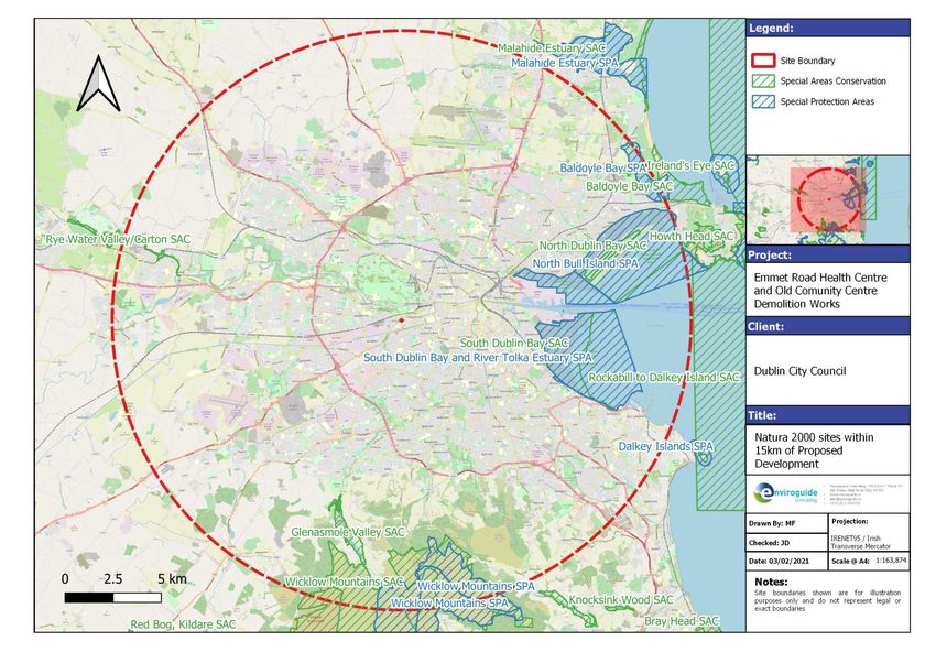
February 2021 Page 103.3 Identification of Relevant Natura 2000 Sites
In order to identify potentially affected European sites, and adopting the precautionary princi-
ple, all SPAs and SACs within a 15km distance radius of the Site of the Proposed Develop-
ment were considered to determine if they were within the zone of influence (ZOI) of the Pro-
posed Development.
The result of this preliminary screening concluded that there is a total of 6 SACs and 4 SPAs
located within the ZOI of the Proposed Development Site. The qualifying interests of these
Natura 2000 sites are detailed in 3. The distances to each site listed are taken from the nearest
possible point of the Proposed Development Site boundary. The NPWS Site Synopses docu-
ment for each site; providing a description of the site and its respective features of conserva-
tion interest, can be found at https://www.npws.ie/protected-sites and have not been ap-
pended to this report in the interests of sustainable paper usage.
TABLE 3 NATURA 2000 SITES WITHIN THE PRECAUTIONARY ZONE OF INFLUENCE OF THE PROPOSED
DEVELOPMENT SITE
Site Name & Code Qualifying Interests ( *= priority habitats) Distance to Site
Special Areas of Conservation (SAC)
[1140] Tidal Mudflats and Sandflats
South Dublin Bay SAC [1210] Annual vegetation of drift lines
6.9km east
(000210) [1310] Salicornia and other annuals colonising mud and sand
[2110] Embryonic shifting dunes
[1140] Tidal Mudflats and Sandflats
[1210] Annual Vegetation of Drift Lines
[1310] Salicornia Mud
[1330] Atlantic Salt Meadows
North Dublin Bay SAC [1410] Mediterranean Salt Meadows 9.3km south
(000206) [2110] Embryonic Shifting Dunes east
[2120] Marram Dunes (White Dunes)
[2130] Fixed Dunes (Grey Dunes)*
[2190] Humid Dune Slacks
[1395] Petalwort (Petalophyllum ralfsii)
[6210] Orchid-rich Calcareous Grassland*
Glenasmole Valley SAC
[6410] Molinia Meadows 9.5km south
(001209)
[7220] Petrifying Springs*
[3110] Oligotrophic Waters containing very few minerals
[3130] Mixed Najas flexilis lake habitat
Wicklow Mountains SAC
[3160] Dystrophic Lakes 11.4km south
(002122)
[4010] Wet Heath
[4030] Dry Heath
February 2021 Page 11[4060] Alpine and Subalpine Heaths
[6130] Calaminarian Grassland
[6230] Species-rich Nardus Grassland*
[7130] Blanket Bogs (Active)*
[8110] Siliceous Scree
[8210] Calcareous Rocky Slopes
[8220] Siliceous Rocky Slopes
[91A0] Old Oak Woodlands
[1355] Otter (Lutra lutra)
[7220] Petrifying Springs*
Rye Water Valley/Carton
[1014] Narrow-mouthed Whorl Snail (Vertigo angustior) 11.7km west
SAC (001398)
[1016] Desmoulin's Whorl Snail (Vertigo moulinsiana)
[1140] Tidal Mudflats and Sandflats
Baldoyle Bay SAC [1310] Salicornia Mud 13.8km north
(000199) [1330] Atlantic Salt Meadows east
[1410] Mediterranean Salt Meadows
Special Protection Areas
[A046] Light-bellied Brent Goose (Branta bernicla hrota) [win-
tering]
[A130] Oystercatcher (Haematopus ostralegus) [wintering]
[A137] Ringed Plover (Charadrius hiaticula) [wintering]
[A141] Grey Plover (Pluvialis squatarola) [wintering]
[A143] Knot (Calidris canutus) [wintering]
[A144] Sanderling (Calidris alba) [wintering]
South Dublin Bay and
[A149] Dunlin (Calidris alpina) [wintering]
River Tolka Estuary SPA 6.2km north east
[A157] Bar-tailed Godwit (Limosa lapponica) [wintering]
(004024)
[A162] Redshank (Tringa totanus) [wintering]
[A179] Black-headed Gull (Chroicocephalus ridibundus) [win-
tering]
[A192] Roseate Tern (Sterna dougallii) [passage]
[A193] Common Tern (Sterna hirundo) [breeding] [passage]
[A194] Arctic Tern (Sterna paradisaea) [breeding] [passage]
[A999] Wetland and Waterbirds
[A046] Light-bellied Brent Goose (Branta bernicla hrota) [win-
tering]
[A048] Shelduck (Tadorna tadorna) [wintering]
North Bull Island SPA
[A052] Teal (Anas crecca) [wintering] 9.2km north east
(004006)
[A054] Pintail (Anas acuta) [wintering]
[A056] Shoveler (Anas clypeata) [wintering]
[A130] Oystercatcher (Haematopus ostralegus) [wintering]
February 2021 Page 12[A140] Golden Plover (Pluvialis apricaria) [wintering]
[A141] Grey Plover (Pluvialis squatarola) [wintering]
[A143] Knot (Calidris canutus) [wintering]
[A144] Sanderling (Calidris alba) [wintering]
[A149] Dunlin (Calidris alpina) [wintering]
[A156] Black-tailed Godwit (Limosa limosa) [wintering]
[A157] Bar-tailed Godwit (Limosa lapponica) [wintering]
[A160] Curlew (Numenius arquata) [wintering]
[A162] Redshank (Tringa totanus) [wintering]
[A169] Turnstone (Arenaria interpres) [wintering]
[A179] Black-headed Gull (Chroicocephalus ridibundus) [win-
tering]
[A999] Wetland and Waterbirds
Wicklow Mountains SPA [A098] Merlin (Falco columbarius) [breeding]
11.3km south
(004040) [A103] Peregrine (Falco peregrinus) [breeding]
[A046] Light-bellied Brent Goose (Branta bernicla hrota) [win-
tering]
[A048] Shelduck (Tadorna tadorna) [wintering]
Baldoyle Bay SPA [A137] Ringed Plover (Charadrius hiaticula) [wintering] 14.2km north
(004016) [A140] Golden Plover (Pluvialis apricaria) [wintering] east
[A141] Grey Plover (Pluvialis squatarola) [wintering]
[A157] Bar-tailed Godwit (Limosa lapponica) [wintering]
[A999] Wetland and Waterbirds
February 2021 Page 13FIGURE 5 NATURA 2000 SITES WITHIN 15KM OF THE PROPOSED DEVELOPMENT
February 2021 Page 143.3.1 Fauna
Species listed as solely Annex IV or V do not have a designated SAC or SPA area and so
need to be considered separately. Similarly, certain Annex II species have the potential to
occur outside their designated areas due to their mobile nature e.g. Marsh Fritillary Butterfly,
Otter etc. Available data, records and survey results of these species are therefore outlined
below.
3.3.1.1 Otter
The Proposed Development occurs within National Ordnance Survey 2km grid square O13G.
Otter have been recorded in the Grand Canal to the south-east and south-west of the Pro-
posed Development Site. These are outlined in Figure 6 and Figure 7 below. All records in
this figure are from the Atlas of Mammals in Ireland 2010-2015 and are based on live animal
sightings.
According to the Dublin City Otter Survey (Macklin et al., 2019), otter do also utilise the Camac
river which passes within ca. 80m of the Site’s northern boundary. Just over seven kilometres
of the Camac river channel was surveyed (7.3km). Eight otter signs (4 spraints, 1 couch, 1
latrine and 1 active hold) were recorded along the entire stretch, equating to 1.1 signs per
kilometre of channel (Macklin et al., 2019). Otter signs along the Camac were clustered in
three areas within the upper and middle and reaches, namely Nangor Road, Bluebell and
Inchicore. Several signs were recorded by Macklin et al. (2019) along the stretch of Camac
immediately north of the Site of the Proposed Development although these consisted of
spraints, smear and a couch, with no holts recorded in the area.
FIGURE 6 OTTER RECORDS FROM THE NATIONAL BIODIVERSITY DATA CENTRE. CORRESPONDING
RECORD DATES ARE AS FOLLOWS: (A) 02/01/2010; (B) 12/02/2016; (C) 10/08/2014. ALL RECORDS ARE
FROM THE ATLAS OF MAMMALS IN IRELAND 2010-2015 DATASET AND ARE OF LIVE SIGHTINGS.
February 2021 Page 15FIGURE 7 OTTER SIGN DISTRIBUTION ON THE SURVEYED REACHES OF THE CAMAC RIVER AS SUR-
VEYED APRIL 2018-APRIL 2019 BY TRITURUS ENVIRONMENTAL LTD. (ADAPTED FROM MACKLIN ET
AL., 2019).
3.3.2 Light-bellied Brent Geese and other SCI bird species
Data from the Light-bellied Brent Geese surveys carried out by Benson (2008/09), Scott Caw-
ley Ltd. (2016/17) and Enviroguide Consulting (2018/19 and 2019/20) were reviewed. The
nearest identified ex situ feeding site to the Proposed Development is the Good Council, lo-
cated 694m south-east from the Site. Brickfield Park is located 838m south-east, and Dolphin’s
Barn Green is located 1km south east. Peak counts of other SCI species recorded during the
surveys were also reviewed.
3.3.3 Invasive plant species
One invasive plant species was recorded during Site surveys; a stand of Buddleia (Buddleja
davidii) or ‘Butterfly bush’, located in proximity to the Pigeon club building.
February 2021 Page 163.4 Identification and Assessment of Potential Impacts
Information available on the European sites within the identified precautionary zone of influ-
ence (ZOI) was reviewed and assessed in order to establish whether the Proposed Develop-
ment has the potential to have an impact on any of the qualifying interests and/or conservation
objectives of identified European sites. The identification of likely significant effects on Euro-
pean sites considered all potential linkages as a result of the Proposed Development.
The assessment framework is taken from the best practice guidelines issued by the European
Commission, i.e. “Assessment of plans and projects significantly affecting Natura 2000 sites
– Methodological guidance”.
3.4.1 Assessment of Potential Impacts
The potential for significant impacts associated with the Proposed Development was assessed
through the use of key indicators, namely:
• Habitat loss or alteration
• Habitat/species fragmentation
• Disturbance and/or displacement of species
• Changes in population density
• Changes in water quality and resource
The following elements of the Proposed Development were assessed for their potential for
likely significant effects on Natura 2000 sites.
Demolition process (estimated duration 3-6 months)
• Increased noise, dust and/or vibrations as a result of demolition activity;
• Increased dust and air emissions from demolition traffic;
• Increased lighting in the vicinity as a result of demolition activity;
• Increased human presence in the vicinity as a result of the demolition works; and
• Surface water run-off containing silt, sediments and/or other pollutants into nearby
waterbodies.
The features of the Proposed Development that have the potential to directly or indirectly im-
pact on the qualifying interests and/or conservation objectives of the European Sites that are
located within the precautionary ZOI (15km) of Site of the Proposed Development are detailed
in Table 4.
3.4.1.1 Habitat Loss and Alteration
The project is not located within any Natura 2000 site and therefore there will be no loss or
alteration of habitat as a result of the Proposed Development.
3.4.1.2 Habitat / Species Fragmentation
Habitat fragmentation has been defined as the ‘reduction and isolation of patches of natural
environment’ (Hall et al., 1997 cited in Franklin et al., 2002) usually due to an external disturb-
ance such that an alteration of the spatial composition of a habitat occurs that alters the habitat
and ‘create[s] isolated or tenuously connected patches of the original habitat’ (Wiens, 1989
cited in Franklin et al., 2002). This results in spatial separation of habitat units which had pre-
viously been in a state of greater continuity.
February 2021 Page 17As there will be no direct habitat loss within any Natura 2000 site, it is not considered that
habitat fragmentation will arise as a result of the Proposed Development.
3.4.1.3 Disturbance and / or Displacement of Species
Several SCI species listed for the South Dublin Bay and River Tolka Estuary SPA, and North
Bull Island SPA; namely Light-bellied Brent Geese, Oystercatcher and Black-headed Gull,
have been recorded during Wintering Bird Surveys carried out by Enviroguide (2018/19 and
2019/20 seasons) at known ex-situ foraging sites in the vicinity of the Proposed Development.
Due to the distance involved between these ex-situ sites, and the Site of the Proposed Devel-
opment, it is deemed that there is no potential for likely significant impacts to these species,
should they be utilising these sites, as a result of disturbance due to noise, dust or increased
human activity at the Site of the Proposed Development during the demolition works.
The land immediately to the south of the Proposed Development has also been considered
as regards its potential as an ex-situ feeding ground for the above species. The green space
which makes up the majority of the lands is categorised as ‘GA2- Amenity Grassland’ habitat
(as per Fossitt, 2000), and covers an area that was resewn after the demolition of several
buildings at the Site over the course of the last decade. Although this type of habitat theoreti-
cally has the potential to provide suitable ex-situ foraging habitat for several SCI species listed
for this SPA, this particular area of grassland has not been noted as an ex-situ feeding site in
Wintering Bird Surveys (WBS) carried out over the last decade (Benson, 2009; Scott-Cawley,
2015-17; Enviroguide 2018-20) and is therefore not deemed to be a site of ex-situ importance.
With regard to Otter, although this mammal species is known to utilise the Grand Canal and
the stretch of the Camac to the north of the Site, it is deemed that significant disturbance/
displacement impacts to Otter as a result of the Proposed Development are highly unlikely.
This is largely due to the built-up, urban nature of the surrounding area and the associated
baseline noise level that this environment would entail; the lack of any suitable otter habitat
within close proximity to the Site, and the short-term duration of the demolition works. It is also
noted that Otter are predominantly active during dawn and dusk, and as such would largely
avoid the expected period of daily works at the Site. In addition, these works will be subject to
significant noise control measures due to their immediate proximity to sensitive receptors in
the form of residential housing, particularly along Emmet Road directly across from the Site.
These measures will also act to further remove any possibility of construction related noise
impacts to otter should they be present in the locality of the Site.
3.4.1.4 Changes in Population Density
It is not expected that the Proposed Development will cause any reduction in the baseline
population of species associated with any Natura 2000 site.
3.4.1.5 Changes in Water Quality and Resource
Due to the fact that there is a considerable minimum distance between the Proposed Devel-
opment site and any of the Natura 2000 sites identified in Table 3; and that the Proposed
Development will implement standard best practice measures to ensure surface water protec-
tion during the demolition works, is not considered that there is any significant potential for
contamination or adverse effects to water quality or resource in any Natura 2000 site.
The following standard best practice and project design measures will protect surface waters
during the Demolition Phase of the Proposed Development:
February 2021 Page 18• Any demolition waste generated will be stored on Site in the designated storage loca-
tion.
• Refuelling of plant during the Demolition Phase will only be carried out at designated
refuelling station locations on site. Each station will be fully equipped for spill response
and a specially trained and dedicated Environmental and Emergency Spill Response
team will be appointed before the commencement of works on site.
• Only emergency breakdown maintenance will be carried out on site. Drip trays and
spill kits will be available on site to ensure that any spills from vehicles are contained
and removed off site;
• All personnel working on site will be trained in pollution incident control response. Spill
response procedures contained within the project design will ensure that appropriate
information will be available on site outlining the spillage response procedures and a
contingency plan to contain silt during an incident;
• Any other diesel, fuel or hydraulic oils stored on site will be stored in bunded storage
tanks- the bunded area will have a volume of at least 110% of the volume of the stored
materials as per best practice guidelines (IPC Guidance Note on Storage and Transfer
of Materials for Scheduled Activities, EPA 2004);
• Portaloos and/or containerised toilets and welfare units will be used to provide facilities
for site personnel. All associated waste will be removed from site by a licenced waste
disposal contractor.
TABLE 4 IDENTIFICATION OF POTENTIAL IMPACTS TO NATURA 2000 SITES.
Natura 2000 site Potential for significant impacts on Natura 2000 site
Special Areas of Conservation (SAC)
No possibility of likely significant effects on SAC due to:
The intervening minimum distance of ca. 6.9km between the Proposed Develop-
ment and the SAC.
- This intervening distance is considered sufficient to exclude the possibility of sig-
nificant effects on the SAC arising from: emissions of noise, dust, pollutants and/or
vibrations emitted from Site of the Proposed Development during the demolition
process; increased traffic volumes during the demolition and associated emissions;
potential increased lighting emitted from Site of the Proposed Development during
South Dublin Bay SAC the demolition process; and increased human presence at the Site of the Proposed
Development during the demolition process.
The considerable minimum distances between the Proposed Development site and
the SAC; and the correct implementation of standard best practice measures will
ensure surface water protection during demolition works, and is not considered
that there is any significant potential for contamination or adverse effects to water
quality or resource for the SAC.
The lack of any habitat types listed as qualifying interests (QIs) for the SAC present
at the Site of the Proposed Development; in addition to the lack of any faunal spe-
cies listed as qualifying interests (QIs) for this SAC.
February 2021 Page 19- The Proposed Development will not result in the reduction/fragmentation of any:
- Habitats listed as QIs for the SAC
No possibility of likely significant effects on SAC due to:
The intervening minimum distance of over 9.3km between the Proposed Develop-
ment and the SAC.
- This intervening distance is considered sufficient to exclude the possibility of sig-
nificant effects on the SAC arising from: emissions of noise, dust, pollutants and/or
vibrations emitted from Site of the Proposed Development during the demolition
process; increased traffic volumes during the demolition and associated emissions;
potential increased lighting emitted from Site of the Proposed Development during
the demolition process; and increased human presence at the Site of the Proposed
Development during the demolition process.
The considerable minimum distances between the Proposed Development site and
the SAC; and the correct implementation of standard best practice measures will
North Dublin Bay SAC
ensure surface water protection during demolition works, and is not considered
that there is any significant potential for contamination or adverse effects to water
quality or resource for the SAC.
The lack of any habitat types listed as qualifying interests (QIs) for the SAC present
at the Site of the Proposed Development; in addition to the lack of any faunal spe-
cies listed as qualifying interests (QIs) for this SAC.
- Petalwort (Petalophyllum ralfsii) growth at Bull Island occurs along the track that
cuts through the Alder marsh, south and east of St. Anne's Golf Club [Data from
NPWS surveys and Campbell (2013)]. Examples of this suitable humid, sandy en-
vironment is not present at the Site of the Proposed Development.
- The Proposed Development will therefore not result in the reduction/fragmentation
of any habitats listed as QIs for the SAC; or habitats associated with QI species
Petalwort.
No possibility of likely significant effects on SAC due to:
The intervening minimum distances of ca. 9.5km between the Proposed Develop-
ment and the SAC.
- This intervening distance is considered sufficient to exclude the possibility of sig-
nificant effects on the SAC arising from: emissions of noise, dust, pollutants and/or
vibrations emitted from Site of the Proposed Development during the demolition
Glenasmole Valley SAC works; increased traffic volumes during the demolition works and associated emis-
sions; potential increased lighting emitted from Site of the Proposed Development
during demolition works; and increased human presence at the Site of the Pro-
posed Development during demolition works.
The lack of any hydrological connections between the Proposed Development and
the SAC.
- There are no possible hydrological pathways for potential surface water discharges
containing sediment, silts and/or pollutants associated with demolition works of the
Proposed Development; and potential flooding events at the Site of the Proposed
February 2021 Page 20Development; entering the SAC and causing any changes in water quality and re-
source.
The lack of any habitat types listed as qualifying interests (QIs) for the SAC present
at the Site of the Proposed Development; in addition to the lack of any faunal spe-
cies listed as qualifying interests (QIs) for this SAC.
- The Proposed Development will not result in the reduction/fragmentation of any
habitats listed as QIs for the SAC.
No possibility of likely significant effects on SAC due to:
The intervening minimum distance of ca. 11.4km between Site of the Proposed De-
velopment and the SAC.
- This intervening distance is considered sufficient in order to exclude the possibility
of significant effects on the SAC arising from: emissions of noise, dust, pollutants
and/or vibrations emitted from Site of the Proposed Development during the dem-
olition works; increased traffic volumes during the demolition works and associated
emissions; potential increased lighting emitted from Site of the Proposed Develop-
ment during demolition works; and increased human presence at the Site of the
Proposed Development during demolition works.
The lack of any hydrological connection between Site of the Proposed Develop-
ment and the SAC;
- The SAC, located a considerable distance in the mountains to the South of Site of
the Proposed Development, is located upstream and therefore maintains no pos-
sible hydrological pathway for potential surface water discharges containing sedi-
Wicklow Mountains SAC ment, silts and/or pollutants associated with the demolition works of the Proposed
Development; as well as potential flooding events at the Site of the Proposed De-
velopment, entering the SAC and causing any changes in water quality and re-
source.
- In addition, the correct implementation of standard best practice measures will en-
sure surface water protection during demolition works, and is not considered that
there is any significant potential for contamination or adverse effects to water qual-
ity or resource that could impact of the QIs for the SAC.
The lack of any habitat types listed as qualifying interests (QIs) for the SAC pre-
sent at the Site of the Proposed Development; and the lack of any disturbance
impacts to Otter (Lutra lutra) as a result of the Proposed Development;
- The Proposed Development will therefore not result in the reduction/fragmentation
of any:
• Habitats listed as QIs for the SAC;
• Habitats associated with faunal species listed as QIs for the SAC; or
• Populations of faunal species listed as QIs for the SAC.
No possibility of likely significant effects on SAC due to:
The intervening minimum distances of ca. 11.7km between the Proposed Develop-
Rye Water Valley/Carton ment and the SAC.
SAC - This intervening distance is considered sufficient to exclude the possibility of sig-
nificant effects on the SAC arising from: emissions of noise, dust, pollutants and/or
vibrations emitted from Site of the Proposed Development during demolition works;
increased traffic volumes during demolition works and associated emissions; po-
tential increased lighting emitted from Site of the Proposed Development during
February 2021 Page 21demolition works; and increased human presence at the Site of the Proposed De-
velopment during demolition works.
The lack of any hydrological connections between the Proposed Development and
the SAC.
- The SAC is located along the Rye Water River which becomes the Liffey River
approx. 11.7km from the Site of the Proposed Development. The nearest river sys-
tem to the Site of the Proposed Development is the Camac which joins the Liffey
itself a considerable distance downstream of this point. Thus, there are no possible
hydrological pathways for potential surface water discharges containing sediment,
silts and/or pollutants associated with demolition works of the Proposed Develop-
ment; and potential flooding events at the Site of the Proposed Development; en-
tering the SAC and causing any changes in water quality and resource.
The lack of any habitat types listed as qualifying interests (QIs) for the SAC present
at the Site of the Proposed Development; and the lack of any suitable Whorl Snail
habitat located within the Site.
- The Proposed Development will therefore not result in the reduction/fragmentation
of any:
• Habitats listed as QIs for the SAC;
• Habitats associated with faunal species listed as QIs for the SAC; or
• Populations of faunal species listed as QIs for the SAC.
No possibility of likely significant effects on SAC due to:
The intervening minimum distance of 13.8km between the Proposed Development
and the SAC.
- This intervening distance is considered sufficient to exclude the possibility of sig-
nificant effects on the SAC arising from: emissions of noise, dust, pollutants and/or
vibrations emitted from Site of the Proposed Development during demolition works;
increased traffic volumes during demolition works and associated emissions; po-
tential increased lighting emitted from Site of the Proposed Development during
demolition works; and increased human presence at the Site of the Proposed De-
velopment during demolition works.
Baldoyle Bay SAC The lack of any habitat types listed as qualifying interests (QIs) for the SAC present
at the Site of the Proposed Development; in addition to the lack of any faunal spe-
cies listed as qualifying interests (QIs) for this SAC.
- The Proposed Development will therefore not result in the reduction/fragmentation
of any habitats listed as QIs for the SAC
The lack of any direct hydrological connections between the Proposed Develop-
ment and the SAC.
- There is a significant marine buffer present between the outflow of the River Liffey
and the SAC. It is therefore deemed that there is no pathway for potential surface
water run-off containing sediment, silts and/or pollutants associated with demolition
works of the Proposed Development; and potential flooding events at the Site of
the Proposed Development; to enter the SAC and causing any changes in water
quality and resource.
Special Protection Areas (SPA)
February 2021 Page 22No possibility of likely significant effects on SPA due to:
The intervening minimum distance of ca. 6.2km between the Proposed Develop-
ment and the SPA.
- This intervening distance is considered sufficient to exclude the possibility of sig-
nificant effects on the SPA arising from: emissions of noise, dust, pollutants and/or
vibrations emitted from Site of the Proposed Development during the demolition
works; increased traffic volumes during the demolition works and associated emis-
sions; potential increased lighting emitted from Site of the Proposed Development
during demolition works; and increased human presence at the Site of the Pro-
posed Development during demolition works.
The considerable minimum distances between the Proposed Development site and
South Dublin Bay and River the SPA; and the correct implementation of standard best practice measures will
Tolka Estuary SPA ensure surface water protection during demolition works, and is not considered
that there is any significant potential for contamination or adverse effects to water
quality or resource for the SPA.
The lack of important ex-situ habitat for SCI species within, or within close proxim-
ity, to the Site of the Proposed Development.
- The Site itself is not an important ex-situ feeding site for SCI species listed for this
SPA.
- Known nearby ex-situ feeding sites for Light-bellied Brent geese are located at suf-
ficient distances from the Site as to not be susceptible to disturbances as a result
of emissions of noise, dust, pollutants and/or vibrations emitted from Site of the
Proposed Development during the demolition works; and potential increased light-
ing and human presence at the Site of the Proposed Development during demoli-
tion works.
No possibility of likely significant effects on SPA due to:
The intervening minimum distance of ca. 9.2km between the Proposed Develop-
ment and the SPA.
- This intervening distance is considered sufficient to exclude the possibility of sig-
nificant effects on the SPA arising from: emissions of noise, dust, pollutants and/or
vibrations emitted from Site of the Proposed Development during the demolition
works; increased traffic volumes during the demolition works and associated emis-
sions; potential increased lighting emitted from Site of the Proposed Development
during demolition works; and increased human presence at the Site of the Pro-
posed Development during demolition works.
The considerable minimum distances between the Proposed Development site and
North Bull Island SPA
the SPA; and the correct implementation of standard best practice measures will
ensure surface water protection during demolition works, and is not considered
that there is any significant potential for contamination or adverse effects to water
quality or resource for the SPA.
The lack of important ex-situ habitat for SCI species within, or within close proxim-
ity, to the Site of the Proposed Development.
- The Site itself is not an important ex-situ feeding site for SCI species listed for this
SPA.
Known nearby ex-situ feeding sites for Light-bellied Brent geese are located at sufficient
distances from the Site as to not be susceptible to disturbances as a result of emissions
of noise, dust, pollutants and/or vibrations emitted from Site of the Proposed Development
February 2021 Page 23during the demolition works; and potential increased lighting and human presence at the
Site of the Proposed Development during the demolition works.
No possibility of likely significant effects on SPA due to:
The intervening minimum distance of ca. 11.3km between the Proposed Develop-
ment and the SPA.
- This intervening distance is considered sufficient to exclude the possibility of sig-
nificant effects on the SPA arising from: emissions of noise, dust, pollutants and/or
vibrations emitted from Site of the Proposed Development during the demolition
works; increased traffic volumes during the demolition works and associated emis-
sions; potential increased lighting emitted from Site of the Proposed Development
during demolition works; and increased human presence at the Site of the Pro-
posed Development during demolition works.
The lack of any hydrological connection between the Site of the Proposed Devel-
Wicklow Mountains SPA opment and the SPA;
- The SPA is located in the mountains ca.11.1km to the south of the Proposed De-
velopment, and maintains no possible hydrological pathway for potential surface
water discharges containing sediment, silt and/or pollutants associated with the
demolition works of the Proposed Development and potential flooding events at the
Site of the Proposed Development, to enter the SPA and causing any changes in
water quality and resource.
The lack of suitable habitat for qualifying interests of the SPA within, or within close
proximity, to the Proposed Development.
Peregrine (Falco peregrinus) have been shown to have a hunting range of between ca.
2-6km from the nest (Pendlebury et al, 2011 & Hardey, 2007) and Merlin (Falco colum-
barius) will forage up to ca. 4km from the nest (Pendlebury et al, 2011), therefore the
Proposed Development lands are not considered likely to form part of any important ex-
situ foraging area for either of these species.
No possibility of likely significant effects on SPA due to:
The intervening minimum distance of ca. 14.2km between the Proposed Develop-
ment and the SPA.
- This intervening distance is considered sufficient to exclude the possibility of sig-
nificant effects on the SPA arising from: emissions of noise, dust, pollutants and/or
vibrations emitted from Site of the Proposed Development during the demolition
works; increased traffic volumes during the demolition works and associated emis-
sions; potential increased lighting emitted from Site of the Proposed Development
Baldoyle Bay SPA during demolition works; and increased human presence at the Site of the Pro-
posed Development during demolition works.
The lack of any direct hydrological connections between the Proposed Develop-
ment and the SPA.
- There is a significant marine buffer present between the River Liffey and the SPA.
It is therefore deemed that there is no pathway for potential surface water run-off
containing sediment, silts and/or pollutants associated with demolition works of the
Proposed Development; and potential flooding events at the Site of the Proposed
Development; to enter the SPA and causing any changes in water quality and re-
source.
February 2021 Page 24The lack of important ex-situ habitat for SCI species within, or within close proxim-
ity, to the Site of the Proposed Development.
- The Site itself is not an important ex-situ feeding site for SCI species listed for this
SPA.
- Known nearby ex-situ feeding sites for Light-bellied Brent geese are located at suf-
ficient distances from the Site as to not be susceptible to disturbances as a result
of emissions of noise, dust, pollutants and/or vibrations emitted from Site of the
Proposed Development during the demolition works; and potential increased light-
ing and human presence at the Site of the Proposed Development during demoli-
tion works.
February 2021 Page 25Enviroguide Consulting Proposed Demolition for Mixed-use Development
Appropriate Assessment Screening Report Emmet Road, Dublin 8
3.5 Potential for In-combination Effects
3.5.1 Existing Planning Permissions
There are several existing granted planning permissions on record in the area, ranging from
small-scale extensions and alterations to existing residential properties to larger-scale devel-
opments.
Relatively large-scale projects which have been granted permission in the area are outlined
below.
Planning Ref: 4260/19. Application Type: Permission. Applicant: Circle Voluntary Housing
Association. Address: Site 1b St. Michael's Estate, Inchicore, Dublin 8. Granted: 13-Dec-
2019. Description: Permission for development at this site (0.72 hectare), known as Site 1b
St. Michael's Estate, Inchicore, Dublin 8 bounded by Richmond Barracks to the north, the rear
of Connolly Avenue to the east and Thornton Heights to the south. The development will con-
sist of a one to four storey older persons housing with supports scheme, incorporating: (i) 52
no. apartment dwellings with balconies; (a) 16 no. 2 bedroom apartments; (b) 36 no. 1.5 bed-
room apartments. (ii) Communal facilities at ground floor level to include a multipurpose room,
additional ancillary spaces, staff offices and a publicly accessible tea room (26.5m2). (iii) Land-
scaping works to include resident courtyards and a landscaped open space (facing the St.
Michaels Estate road) incorporating a new vehicle setdown area. (iv) 15 no. car parking
spaces. (13 no. new car parking spaces to be accessed from an existing vehicular entrance
and the relocation of 2 no. existing car parking spaces adjacent to the new vehicle setdown
area). (v) 52 no. bicycle parking spaces. (vi) (ESB substation), external signage, site perimeter
boundary treatments, plant rooms, waste storage enclosures and all associated ancillary de-
velopment works and services. (vii) The development will consist of the following floor areas:
- Total gross internal floor area (GIA): 4,655m2 (inclusive of all residential, communal, vertical
circulation & ancillary spaces). - Area of external deck/gallery access (excluding balconies):
1,066.6m2. - Area of roof terrace (excluding balconies): 100.1m2. (viii) The building will be
one to four storeys in height, with a top parapet level of 40.04m OD (measuring 14.835m
above finished ground floor level).
Planning Ref: 2453/19. Application Type: Permission. Applicant: Vabtol Limited. Associa-
tion. Address: Site to the rear of 205A, Emmet Road, Inchicore, Dublin 8. Granted: 20-Jun-
2019. Description: Amendment to Planning Ref. No. 3635/16 for the previous approved 4-
storey apartment development in the backlands for the increase in height to six storey building
above semi-basement level consisting of: 6 no. one-bed, 18 no. two-bed apartments; which
include balconies to the north, west & south elevations, additional covered bike storage areas,
refuse store, with revised 18 no. car parking spaces off vehicular access road from Emmet
Road, with associated landscaping & site works.
Planning Ref: 2747/20. Application Type: Permission. Applicant: Durkan (Davitt Road) Ltd.
Address: Former Dulux Factory Site, Davitt Road, Dublin 12, D12 C97T. Granted: 07-Jul-
2020. Description: The development will consist of modifications to development previously
permitted under Reg. Ref. ABP-303435-19 (DCC Ref. SHD0002/19). The modifications for
permission consist of (a) alteration to window format at third and fourth floor level on east and
west elevation to provide windows to corridor only; (b) window format altered at sixth floor
level of south elevation of Blocks A and B; (c) balconies and windows removed from eastern
February 2021 Page 26You can also read