Land rezoning to General Residential Zone Parker St, Castlemaine - Mount Alexander Shire ...
←
→
Page content transcription
If your browser does not render page correctly, please read the page content below
Planning Scheme Amendment C74

 Land rezoning to General Residential Zone
                     Parker St, Castlemaine

                                                 August 2014

                               Prepared for Mr Ewen MacDonald

                                        By TOMKINSON Group

57 Myers Street
Bendigo VIC 3550
PO Box 421
Bendigo VIC 3550
Telephone: 5445 8700
Facsimile: 5441 3648
Email: bendigo@tomkinson.com

© Tomkinson Group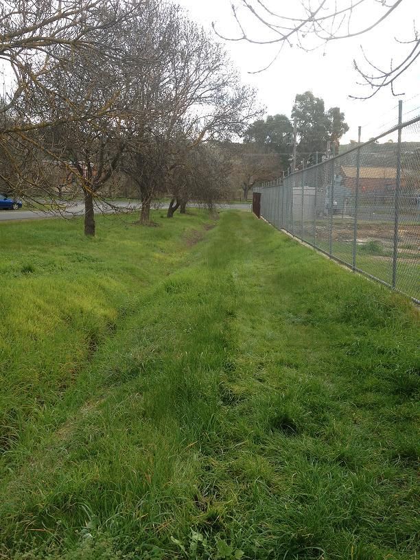
TOMKINSON Group

                                            CONTENTS
1     Introduction                                                                         4
2     Background                                                                           4
3     The Proposal                                                                         5
4     Subject Site – Parker Street, Castlemaine                                            6
         4.1 Location and context                                                          6
         4.2 Integration with existing urban areas                                         14
         4.3 Landscape and heritage values                                                 14
         4.4 Provision of social and physical infrastructure and servicing compatibility   15
         4.5 Referral authority response                                                   15
5     Victoria Planning Provisions                                                         17
          5.1 Ministerial Direction No 1, Potentially Contaminated Land                    17
          5.2 Mount Alexander Planning Scheme                                              17
              5.2.1 State Planning Policy Framework                                        17
              5.2.2 Plan Melbourne and the Loddon Mallee South Regional Growth Plan        23
           5.3 Local Planning Policy Framework                                             24
              5.3.1 Municipal Strategic Statement                                          24
              5.3.2 Local Planning Policies                                                27
          5.4 Castlemaine Residential Strategy                                             28
          5.5 Castlemaine Land Use Strategy                                                29
          5.6 Residential Land Demand and Supply Analysis                                  31
6     Population, settlement and housing                                                   31
         6.1 Mount Alexander Shire context                                                 31
         6.2 Population                                                                    32
         6.3 Settlement trends                                                             33
         6.4 Housing supply                                                                34
7     Proposed planning scheme controls and other mechanisms                               36
         7.1 General Residential Zone (GRZ)                                                36
         7.2 Development Plan Overlay, Schedule 8                                          36
         7.3 Design and Development Overlay, Schedule 13                                   37
         7.4 Environmental Audit Overlay                                                   38
         7.5 Changes to the Mount Alexander Planning Scheme                                39
8     Conclusion                                                                           40

    Planning Scheme Amendment to rezone land to General Residential Zone                       2
    Parker St, Castlemaine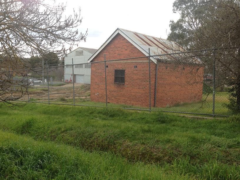
TOMKINSON Group

                                               LIST OF FIGURES
4.1       Figure 1: Subject site – Parker St, Castlemaine                                           6
5.2.2      Figure 2: Map 13, p.50, Loddon Mallee South Regional Growth Plan                         22
5.3       Figure 3: Life House Design                                                               30

6.1       Figure 4: Castlemaine district and concentration of urban development along highways      32
6.2       Figure 5: Population statistics for Castlemaine 1981-2011 (Source: Australian Bureau of   32
          Statistics)
6.4       Figure 6: Residential Building approvals in Mount Alexander Shire                         35

                                            LIST OF APPENDICES
A         Site and context plan                                                                     41
B         Environmental Site Assessment, prepared by Environmental Strategies Global Pty Ltd        42
C         Proposed Development Plan Overlay, Schedule 8                                             43
D         Proposed Design and Development Overlay, Schedule 13                                      34
E         Proposed Environmental Audit Overlay                                                      45
F         Infrastructure Assessment                                                                 46
G         Referral authority responses                                                              47
H         Neighbourhood correspondence                                                              48
I         Mapping Changes                                                                           49
J         Draft instruction sheet                                                                   50

        Planning Scheme Amendment to rezone land to General Residential Zone                            3
        Parker St, Castlemaine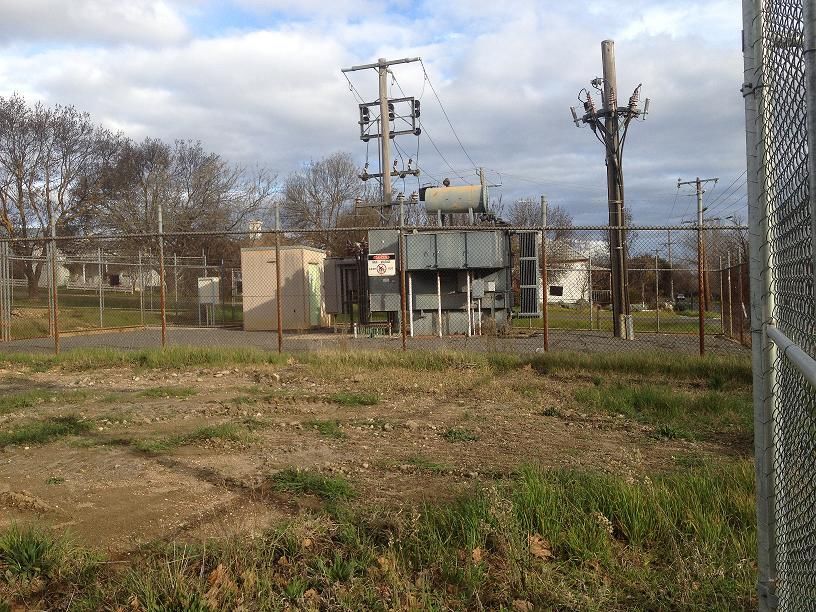
TOMKINSON Group
1. Introduction
This report has been prepared for Mr Ewen MacDonald in support of a planning scheme amendment (C74) to
rezone 6000m2 of land in the Mount Alexander Shire to General Residential Zone and apply a Development
Plan Overlay (Schedule 8), a Design and Development Plan Overlay (Schedule 13), and an Environmental
Audit Overlay to provide parameters for any future development.
The report provides a comprehensive assessment of the suitability of the site for proposed rezoning for
residential development against the requirements of Ministerial Directions No. 1 Potentially Contaminated
Land, State and Local planning policies and provisions of the Mount Alexander Planning Scheme (the
Scheme). The report contains a number of sections:
Section 2 sets out the background to this proposal
Section 3 summarises the proposal
Section 4 provides an analysis of the site and the surrounding area
Section 5 presents a discussion on the strategic basis for the amendment
Section 6 addresses the Victorian Planning Provisions and other relevant provisions
Section 7 provides a summary of changes required to the Planning Scheme
Section 8 provides a conclusion to the report
This report and attached documentation support the process to make the necessary changes to the planning
scheme and establish appropriate mechanisms to facilitate future development and provide efficient,
sustainable and appropriate housing outcomes.
2. Background
Mr Ewen MacDonald purchased the subject site in 2013 from Flowserve (manufacturers of pumps and
pumping equipment), and spent some months considering the options available for the site under its current
Industrial Zone.
Uses permitted under the current zoning were given consideration, and on balance it was determined that a
more acceptable land use outcome for the site, in keeping with the surrounding land use pattern, would be
achieved through residential rezoning.
Our client therefore seeks to rezone the site to the General Residential Zone, which will bring it in line with the
residential land surrounding to the south and east. Parker Street physically separates the subject site from the
main Flowserve business to the north, and both a road and the railway line abut the subject site to the west.
The site has been used by Flowserve as a storage facility and car park, but with change of ownership there is
potential for its industrial use to be intensified under current zoning regulations. It is considered that rezoning
Planning Scheme Amendment to rezone land to General Residential Zone 4
Parker St, Castlemaine
TOMKINSON Group

for residential purposes will ensure best outcomes for the surrounding residential areas, and will facilitate a
positive contribution to housing in Castlemaine.

A preliminary Environmental Site Assessment was undertaken for the site, by Environmental Strategies Global
Pty Ltd (April 2012, Appendix B). The findings of this assessment support rezoning of the site for residential
purposes, stating that ‘the likelihood of significant impact at the site from previous site usage is considered to
be limited.’

The addition of an Environmental Audit Overlay, Development Plan Overlay and a Design and Development
Overlay (Appendices C-E), drafted in consultation with Council, will further provide for clear strategic direction
on the use and development of the site once rezoned.

Extensive public consultation will be an important part of the rezoning process, and Councillors’ and general
public comments have been sought from the outset. An open letter/information pack was prepared for all
neighbours and was distributed early in 2014, alerting neighbours to a possible planning scheme amendment
application and seeking any comments (Appendix H).

The current proposal to rezone the site to General Residential Zone is consistent with the objectives for
planning for residential development and will provide for efficient land use and a sustainable outcome for the
site.

3. The proposal
This proposal is for an amendment to the Mount Alexander Shire Planning Scheme to rezone land to General
Residential Zone, and apply appropriate overlays to .6ha of land known as 7-9 Parker St, Castlemaine
(Appendix A, Site and Context Plan).

The site is bounded by Parker Street to the north, with Flowserve Australia/Thompsons, Kelley and Lewis Pty
Ltd on the opposite side of Parker Street. Immediately east and south the site abuts General Residential land
(GRZ), to the west is Kennedy Street with the railway line opposite.

This land is owned by Mr Ewen MacDonald, who requests an amendment to the Mount Alexander Shire
Planning Scheme to rezone the land from the current Industrial 1 Zone (IN1Z) to the proposed General
Residential Zone (GRZ) and apply the Development Plan Overlay Schedule 8 (DPO8), Design and
Development Overlay Schedule 13 (DDO13) and the Environmental Audit Overlay (EAO).

A very small section of the site is considered to be an area of Cultural Heritage Sensitivity, however due to the
site having previously been subject to significant ground disturbance associated with long term industrial use, a
Cultural Heritage Management Plan is not required.

It is intended that if the subject Planning Scheme Amendment is approved, Mr MacDonald will lodge a
development plan for Council approval in accordance with DPO8 for the subject site.

Planning Scheme Amendment to rezone land to General Residential Zone                                     5
Parker St, Castlemaine
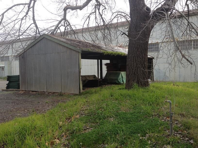
TOMKINSON Group

4. Subject Site
The following assessment of the subject site at Parker, Castlemaine has been carried out against relevant
State and Local planning provisions, as well as the provisions of Ministerial Direction 1.

4.1 Location and context
The amendment applies land known as 7-9 Parker Street, Castlemaine and formally described as CA 1-5 and
CA 20 Section 6, Parish of Castlemaine.

Figure 1: Subject site

The subject site comprises six (6) parcels of land which are currently zoned Industrial 1 Zone (IN1Z) pursuant
to the Mount Alexander Planning Scheme (the Scheme). The site is not subject to any existing overlays. The
site is bounded by Parker Street to the north, Kennedy Street and the railway line to the west, Hunter
Street to the south and GRZ to the south and east.

The site slopes gently east to west, and contains a number of unused storage buildings.

There is one substantial native tree centrally located on the site, and some additional shrubs along boundaries.

Planning Scheme Amendment to rezone land to General Residential Zone                                    6
Parker St, Castlemaine
TOMKINSON Group

Photo 1: Subject site, west to east, note slope and one substantial native tree.

There is also a powercor power pole centrally located on site, although no easement exists on title.

Photo 2: East boundary, power line runs to a pole centrally located on the boundary, but without an easement

Planning Scheme Amendment to rezone land to General Residential Zone                                           7
Parker St, Castlemaine
TOMKINSON Group

There is a substantial portal frame shed along the west boundary of the site, which has been used by
Flowserve most recently for pattern storage.

Photo 3: Portal frame shed, currently empty, on corner of Parker St and Kennedy St

Adjacent to the storage facility, a car port runs along the northern boundary, with additional car parking on
gravel (west and east) and concrete (site entrance off Parker Street).

Photo 4: Carport

Planning Scheme Amendment to rezone land to General Residential Zone                                8
Parker St, Castlemaine
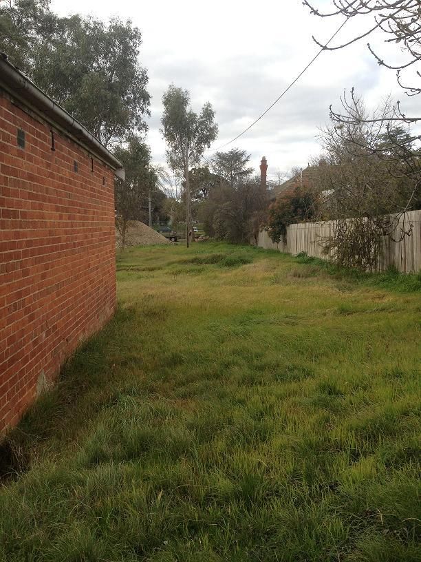
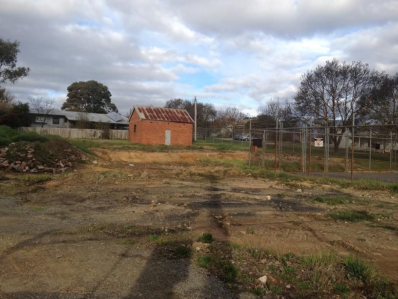
TOMKINSON Group

In the south east corner of the site is a brick store room with some limited heritage appeal.

Photo 5: Brick store room at south east corner

The balance of the site has been used for open storage and for car parking, for employees of Flowserve.
To the north of the site, opposite in Parker Street, is Flowserve’s industrial facility.

Photo 6: subject site north to south, area used for car parking

Planning Scheme Amendment to rezone land to General Residential Zone                                 9
Parker St, Castlemaine
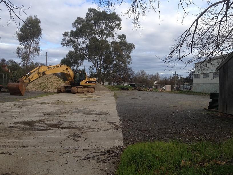
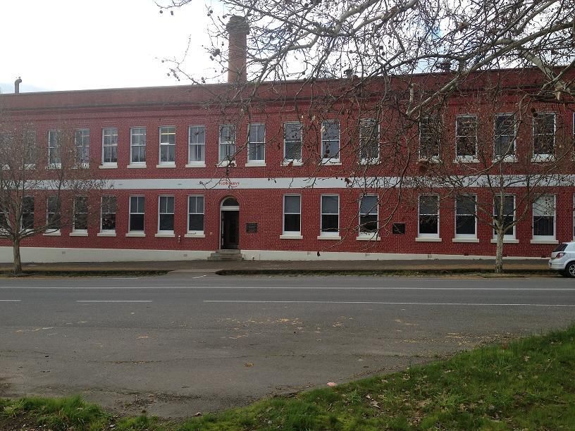
TOMKINSON Group

The subject site is in a block bounded by the Midland Highway to the east, Walker Street to the north, Kennedy
Street to the west and Hunter Street to the south.

Opposite the subject site, on Parker Street, is the Flowserve main building, which is subject to Heritage
Overlay.

Photo 7: Flowserve building, opposite the subject site on Parker Street

Immediately south and east the subject site abuts residential land, zoned GRZ.

Photo 8: Residential along Hunter Street, opposite subject site

Planning Scheme Amendment to rezone land to General Residential Zone                                10
Parker St, Castlemaine
TOMKINSON Group

Photo 9: residential (with Heritage Overlay) on Parker Street, abutting subject site on the east boundary

Photo 10: Subject site west to east, looking towards residential abutting

Planning Scheme Amendment to rezone land to General Residential Zone                                        11
Parker St, Castlemaine
TOMKINSON Group

Photo 11: South boundary, east to west, gentle slope, trees on nature strip

Kennedy Street, on the site’s west boundary, runs adjacent to the Castlemaine-Bendigo railway line.

Photo 12: Kennedy Street and the railway line

Planning Scheme Amendment to rezone land to General Residential Zone                                  12
Parker St, Castlemaine
TOMKINSON Group

The subject site is approximately 900m north of the centre of Castlemaine and within 100m of the Botanical
Gardens.

Photo 13: Parker St, from subject site, across railway line towards Botanical Gardens

A Powercor substation is currently located in the south west corner of the subject site. This substation provides
additional service to Flowserve. It is not used for the general provision of power to Castlemaine. The substation
therefore has potential to be relocated with minimal impact on Flowserve’s operations, and improving the
surrounding residential character.

Photo 13: Existing substation which can be relocated

Planning Scheme Amendment to rezone land to General Residential Zone                                   13
Parker St, Castlemaine
TOMKINSON Group

4.2 Integration with existing urban areas
An Urban Growth Boundary (UGB) has been established for Castlemaine as part of the development of the
Mount Alexander Urban Living Strategy1 and the Castlemaine Residential Strategy2.

The subject site is located inside the designated UGB and the intended proposal promotes infill development
within the Castlemaine UGB, as supported by these residential strategies.

The subject site immediately abuts existing developed residential land to the east and south. To the north,
Parker Street provides a buffer between the subject site and Industrial zoned land. To the west, the railway line
provides a buffer between the subject site and the Woollen Mill facility. Diagonally opposite the north west
corner of the subject site is Castlemaine’s botanical gardens, zoned Public Parks and Recreation Zone.

It is considered that rezoning the subject site for residential purposes will provide more appropriate integration
for the site with the existing land use pattern in this urban area.

4.3 Landscape and heritage values
The subject site is not currently affected by any overlay pertaining to landscape or heritage values (i.e. Heritage
Overlay, Significant Landscape Overlay, Vegetation Protection Overlay or Environmental Significance Overlay).
The site is considered to have some limited landscape and heritage value.

Landscape

The proximity of the Botanical Gardens, and the site’s topography, which will promote views to and from the
gardens, can be considered of landscape value.

Heritage

The site is not subject to Heritage Overlay. Heritage Overlay does apply to a residential building abutting the
subject site’s east boundary, and to the Flowserve Building opposite the subject site – both on Parker Street.

The existing buildings on the subject site are not considered to be of heritage significance. The site’s historical
use as part of the Flowserve operation, and the presence of a significant heritage value Flowserve building
immediately opposite the subject site, in Parker Street, should provide some guidance for future development
of the site in terms of considering and addressing those heritage elements.

The dwelling immediately abutting the subject site to the east, on Parker Street, is subject to a Heritage
Overlay. In addition, many existing dwellings in the area retain heritage content and/or features. The subject
site, therefore, can be considered to retain some heritage value by association.

These elements have been taken into consideration in the preparation of the Development Plan Overlay and
Design and Development Overlay. The proposed overlays have been designed to ensure that any future
development of the site must have consideration for these features.

1
    Planit, Stage Two Report, October 2004
2
    Final Report, August 2005

Planning Scheme Amendment to rezone land to General Residential Zone                                     14
Parker St, Castlemaine
TOMKINSON Group
4.4 Provision of social and physical infrastructure and servicing compatibility
The subject site has excellent access to services in Castlemaine, being only 1km from Castlemaine’s central
commercial area.
In addition, the site is within easy walking distance of the Botanical Gardens, the railway station, hospital
education and medical services.
All servicing requirements for the site could be undertaken through any future subdivision process, based on
further consultation with the relevant agencies. Relevant referral authorities have provided initial support for the
proposal, see 4.8 below.
A preliminary infrastructure assessment has been undertaken, which indicates that the site can be serviced
using existing infrastructure, and that residential development can be supported. (Appendix F, Preliminary
Infrastructure Assessment).
Roads, reticulated water supply and gas, sewer and drainage, power and telecommunications have been
assessed and all services are considered to be feasible for residential purposes.
A substation is located on the north east corner of the site. Investigations have confirmed that relocation of this
substation is feasible. Consideration for relocating the substation would be part of any future development
proposal for the site.
Resource efficiency
Alternative options for water and energy sources and waste management are currently being investigated.
Some options to be investigated by the landowner and consultants include:
Energy efficient lot layouts and building design
Solar power generation
Rainwater harvesting
On site grey water treatment facilities
The proposed overlays will ensure that any future development of the site must have consideration for resource
efficiency and energy efficient design.
4.5 Referral authority responses
All relevant referral authorities have been advised of the proposed rezoning of the subject site.
Authorities will be given the opportunity to assess the detailed application and provide formal
responses.
Following is a summary of informal responses thus far:
Planning Scheme Amendment to rezone land to General Residential Zone 15
Parker St, CastlemaineTOMKINSON Group
Referral Contact Result
Coliban Region Neil Burns, Jason Crowden Emailed 10/2/14 – passed on
Water JasonC@coliban.com.au to concept development team
Corporation 11/2
Resent 5/6, Resent 6/8
No response
Country Fire John Stark/ Andrew Ganey Email response from Rachel
Authority Rachel Rogers Rogers, 3/4/14
r.rogers@cfa.vic.gov.au No objection
Department of Amanda Johnson Emailed 10/2/14
Environment and amanda.johnson@depi.vic.gov.au Resent 5/6
Primary Industry 11/6 No objection
Environment Pat Collins Sent 5/6/14
Protection contact@epa.vic.gov.au Resent 5/6, Resent 6/8
Authority No response as yet
Council’s Tracey Watson Email response 11/2/14
Environmental tracey.watson@mountalexander.vic.gov.au EAO required
Health Unit
Goulburn-Murray Neil Repacholi Response received 10/2/14
Water Neil.Repacholi@gmwater.com.au No objection
Council’s Buddhima Query resent 5/6/14
Infrastructure b.mapa@mountalexander.vic.gov.au Redirected 6/8
Unit Response received
North Central Nathan Treloar Response 17/2/14
Catchment nathan.treloar@nccma.vic.gov.au Decision pending flood study
Management
Authority
Powercor Mary, customer projects Bendigo Emailed 10/2/14
Australia customerprojectsbendigo@powercor.com.au Resent 5/6
No response as yet
Telstra Nadia Richardson Query resent 5/6/14
Nadia.M.Richardson@team.tesltra.com No response as yet
Tenix zac.illic@tenix.com No response
Maintenance Resent 5/6
Services PL No response as yet
VicRoads Kathy Brown Advice from Kathy Brown
(Northern Ravi? 11/2/14 that query had been
Region) nr.mailbox@roads.vic.gov.au passed on – no further
feedback.
Try again 5/6/14
6/6 No objection
VicTrack Emma Demaine Response 13/2/14
Emma.Demaine@VICTRACK.com.au No objection
Responses from referral authorities are included at Appendix G.
Planning Scheme Amendment to rezone land to General Residential Zone 16
Parker St, CastlemaineTOMKINSON Group
In summary, preliminary indication is that relevant referral authorities are generally supportive of the
proposal to rezone the site to General Residential.
5. Victoria Planning Provisions
The Minister for Planning has established for the assessment of strategic amendments to planning schemes.
This includes assessment of any proposed change to a planning scheme against all elements of the planning
scheme’s current relevant policy, and against ministerial directions.
5.1 Ministerial Direction No. 1 – Potentially contaminated land
Ministerial Direction No. 1 relates to potentially contaminated land. The purpose of this Ministerial Direction is
to ensure that an amendment which allows for a more sensitive use of land has regard to the appropriate
strategic considerations and the suitability of land for that development.
A preliminary assessment of the site has been undertaken (see Appendix B), which indicates that the subject
site is unlikely to be contaminated.
This proposal for residential rezoning responds to Ministerial Direction No. 1 by proposing application of an
Environmental Audit Overlay (EAO). The provisions of the EAO would ensure that a full environmental audit
would be required as part of any subsequent development of the site.
5.2 Mount Alexander Planning Scheme
5.2.1 State Planning Policy Framework
The State Planning Policy Framework (SPPF) provides the strategic basis for decision making by
responsible authorities. The SPPF includes policy in relation to settlement, environment, natural
resources, infrastructure, and economic and social well-being. It includes provisions that planning
anticipates and responds to the needs of existing and future communities and assists in the
conservation and sustainable use of natural resources. Essentially, planning decisions should ensure
environmental quality and long term sustainable development.
The following outlines relevant components of the SPPF that relate to the proposal:
Clause 11 – Settlement
This policy affects metropolitan Melbourne and also regional municipalities. In this case, the clause
(11.05) relating to regional planning is relevant:
11.05-4 Regional planning strategies and principles
Planning Scheme Amendment to rezone land to General Residential Zone 17
Parker St, CastlemaineTOMKINSON Group
This policy aims to control development in rural areas to protect agriculture and avoid inappropriate rural
residential development – ensuring planning for rural living avoids or significantly reduces adverse
economic, social and environmental impacts by:
Maintaining the long-term sustainable use and management of existing natural resource attributes
in activities such as agricultural production
Protecting existing landscape values and environmental quality, including water quality, native
vegetation, biodiversity and habitat
Minimising / avoiding property service costs to local and State governments
This proposed amendment facilitates the above objectives, by providing for infill residential
development, utilising existing services.
Clause 12 Environment and Landscape Values
This policy contains planning objectives for the protection of air, land and water quality and the
conservation of natural ecosystems, resources, energy and cultural heritage. Relevant clauses include:
12.01 Biodiversity
The objectives of this clause assist the protection and conservation of biodiversity. The proposed
amendment will not have biodiversity impact, as the land is already cleared and used for industrial
purposes. In fact, the biodiversity of the site is likely to improve with rezoning and a development plan
process that involves residential use and associated landscaping.
Clause 13 Environmental Risks
The objectives of this clause mitigate environmental risks, including climate change, erosion, salinity,
noise, air quality and wildfire.
The subject site is not currently affected by any overlays relating to environmental risks. However the
industrial use history of the site requires careful consideration of environmental risk in compliance with
Ministerial Direction No.1.
An electrical substation is located on the south west corner of the subject site. This substation is used
exclusively to provide power to Flowserve’s operations, on the north side of Parker Street. Preliminary
assessment confirms that the substation can be relocated within Flowserve’s current operation site.
Given the previous industrial use of the site, a preliminary Environmental Site Assessment (Appendix B)
was prepared by Environmental Strategies Global to provide an over-arching assessment of the
environmental status of the site. This report found that the site has historically been used for storage, car
parking, and for manufacturing steel ‘tyres’ has part of the Thompsons, Kelly and Lewis engineering
company.
The Environmental Site Assessment concludes:
Planning Scheme Amendment to rezone land to General Residential Zone 18
Parker St, CastlemaineTOMKINSON Group
Based on the results of the preliminary site assessment, the likelihood of significant impact at the
site from previous site usage is considered to be limited.3
The application of new overlays to the site, including an Environmental Audit Overlay, will ensure that
any proposed future dwellings would be subject to a rigorous planning permit application process.
Clause 15 Built Environment and Heritage
The amendment is consistent with the objectives of the SPPF. In particular, the proposed rezoning of
this site will contribute positively to local character, will reflect characteristics complimentary to the local
community, and will enhance diversity and promote attractiveness of the area and its built environment.
15.01 Urban Environment
The objective of this clause is to create urban environments that are safe, functional and provide good
quality environments with a sense of place and cultural identity.
In considering a proposal to rezone land for urban residential use, the following strategies must be
considered:
Strategy Response
Promote good urban design to make the environment Residential zoning will facilitate good urban design
more liveable and attractive. and an improvement in liveability of the area.
Proposed overlays are designed to ensure a liveable
and attractive outcome for future residential
development.
Ensure new development or redevelopment Redevelopment of the subject site under proposed
contributes to community and cultural life by General Residential Zone will provide Council and
improving safety, diversity and choice, the quality of the community with an opportunity to implement
living and working environments, accessibility and these strategies.
inclusiveness and environmental sustainability.
Require development to respond to its context in Proposed General Residential Zone will provide a
terms of urban character, cultural heritage, natural more responsive context for the subject site, which
features, surrounding landscape and climate. will be more clearly reflective of the surrounding land
use pattern and character.
Require development to include a site analysis and Future redevelopment of the subject site will provide
descriptive statement explaining how the proposed an opportunity for detailed site analysis and
development responds to the site and its context. consideration of the responsiveness of any proposal.
Ensure sensitive landscape areas such as the bays The subject site is not located in a sensitive
and coastlines are protected and that new landscape area, however the proposed rezoning will
development does not detract from their natural nonetheless not have a negative impact on the
quality. natural qualities of the area.
Ensure transport corridors integrate land use The subject site is located in close proximity to the
planning, urban design and transport planning and Midland Highway, which is a part of Castlemaine’s
are developed and managed with particular attention central transport corridor. This application will be
to urban design aspects. referred to VicRoads and Council’s infrastructure unit
3
Initial Phase 1 Environmental Site Assessment, Environmental Strategies Global Pty Ltd (ESG), p.13
Planning Scheme Amendment to rezone land to General Residential Zone 19
Parker St, CastlemaineTOMKINSON Group
for consideration, meeting the strategic intent of this
policy.
Encourage retention of existing vegetation or There is limited existing vegetation on the subject
revegetation as part of subdivision and development site, none of which is proposed for removal with
proposals. rezoning. Under the proposed overlays, landscaping
is an integral component of any future redevelopment
of the site. This will provide opportunity to retain and
manage any vegetation on site.
15.01-2 Urban Design Principles
Residential rezoning of the subject site will promote and facilitate implementation of the urban design
principles outlined under this clause.
Strategy Response
Context Development will take into account the natural,
cultural and strategic context of the location.
The proposed DPO and DDO provide the relevant
planning authority with the tools to:
Require comprehensive site analysis as the
starting point of the design process.
emphasise urban design policies and
frameworks for this location.
Enable consideration of height, scale and
massing of new development.
The public realm Rezoning of the subject site to General Residential
Zone will contribute to the protection and
enhancement of pedestrian spaces, streets, squares,
parks and walkways.
Safety Future residential development will facilitate creation
of urban environments that enhance personal safety
and property security, where people feel safe to live,
work and move in at any time.
Landmark views and vistas The proposed DDO and DPO will ensure that relevant
landmarks, views and vistas will protected and
enhanced or, where appropriate, created by new
additions to the built environment.
Pedestrian spaces Rezoning for residential development will promote
contemporary design of interfaces between buildings
and public spaces, for the purpose of enhancing the
visual and social experience of future users.
Heritage The proposed DDO and DPO provide guidance for
any future development to respect, and not simply
copy, relevant surrounding heritage values and
context.
Consolidation of sites and empty sites Rezoning to General Residential Zone will provide
Planning Scheme Amendment to rezone land to General Residential Zone 20
Parker St, CastlemaineTOMKINSON Group
guidance for future development to contribute to the
complexity and diversity of the built
environment.
Light and shade Future residential development can provide for
enjoyment of the public realm, enhanced by a
desirable balance of sunlight and shade.
Energy and resource efficiency General Residential Zone provisions, along with the
proposed DPO and DDO, will ensure all future
building, subdivision and engineering works will
include consideration of resource and energy
efficiency.
Architectural quality It is expected that the proposed DDO will ensure new
development will achieve high standards in
architecture and urban design.
Landscape architecture Under the proposed planning provisions for the
rezoned site, recognition will be given to the setting in
which buildings are designed and the
integrating role of landscape architecture.
15.01-3 Neighbourhood and subdivision design
Rezoning of the subject site will facilitate implementation of this policy. Outcomes of rezoning will
include:
Reinforcement of Castlemaine’s urban and residential structure, with a network of
neighbourhoods clustered to support the main town activity centres, within the regional public
transport network.
Creation of a compact neighbourhood, within walkable distances of activity centres, services
and facilities.
Contribution to lot size diversity to suit a variety of dwelling and household types, and
responding to the changes needs, aspirations and demographics of Castlemaine’s community.
Additional housing within easy distance of public transport, walking and cycling networks, and a
safe road network, thereby reducing car dependency.
Strengthening of the local sense of place, by reinforcing the residential character of the area,
with an opportunity to provide well designed and attractive built form.
Overlays that promote environmentally friendly development that must include energy
efficiency, water management, landscaping and environmentally sensitive urban design.
Improved accessibility in the area for people with disabilities.
Planning Scheme Amendment to rezone land to General Residential Zone 21
Parker St, CastlemaineTOMKINSON Group
15.01-5 Cultural identity and neighbourhood character
The proposed overlays for the subject site will ensure that any future development recognises and
protects cultural identity, enhances neighbourhood character and promotes a sense of place.
15.02 Sustainable Development
The application of the General Residential Zone in this area of Castlemaine will clearly assist with
meeting the objective to encourage land use and development that is consistent with the efficient use of
energy and the minimisation of greenhouse gas emissions.
The provision of residential use within infill areas, using existing infrastructure and services, is a key
strategy to promote sustainable development and restrict urban sprawl.
15.03 Heritage
The subject site is not subject to a Heritage Overlay, but does abut Heritage Overlay associated with
one dwelling on the north east boundary.
The proposed overlays recognise the presence of this overlay and provide guidance for future
development of the site, which will provide for the conservation and continuing recognition of the
adjacent and nearby architecture of heritage value.
The site is also partially subject to Aboriginal Cultural Heritage Sensitivity, associated with Barkers
Creek environs. There has been, since first settlement of Castlemaine, significant disturbance to this
area of Barkers Creek, including:
Gold mining activity
The railway line running between the subject site and Barkers Creek
Local roads running between the subject site and Barkers Creek
Use of the subject site for industrial purposes
It has therefore been considered that a Cultural Heritage Management Plan will not be required for
rezoning, nor for any future development of the site.
Clause 16 Housing
This policy contains planning objectives to be achieved for different styles of housing. Rezoning of the
site will activate the objectives and strategies outlined, through the development process.
Planning Scheme Amendment to rezone land to General Residential Zone 22
Parker St, CastlemaineTOMKINSON Group
Clause 17 – Economic Development
This policy contains planning objective for different forms of economic development. Planning is to
contribute to the economic well-being of communities and the State as a whole. The proposed
amendment will contribute to the objectives of this Clause as it relates to the Castlemaine area, by the
provision of additional dwellings/people within the existing UGB.
The Mount Alexander Shire Economic Development Strategy and Profile (August 2013) provides some
context for the proposed rezoning to residential use, and embraces concepts of managing growth,
stronger communities, improved infrastructure etc4. This Strategy further notes that the nature of
demand for industrial land and premises in the Shire is changing, with increasing uses that have not
been previously considered industrial5. This suggests that it is timely to reconsider the current industrial
zoning of the subject site.
Clause 19 Infrastructure
The amendment is consistent with the objective of the SPPF. It will foster the development of an area
which is to be located close to existing transport infrastructure networks such as the Calder corridor.
See Appendix F for a preliminary Infrastructure Report, indicating that all relevant services can be
adequately achieved for the site.
5.2.2 Plan Melbourne and the Loddon Mallee South Regional Growth Plan
An important focus of both these strategies is on coordination between city and regional planning for
growth, with particular emphasis on growth along regional transport corridors.
Both of these state planning policies promote the growth of regional cities and key towns on regional
transport corridors as part of a networked cities model (includes the Melbourne-Bendigo corridor with
Plan Melbourne noting Castlemaine as a regional centre).
The Loddon Mallee South Regional Growth Plan (LMSRGP) identifies Castlemaine as ‘regional
centre/township’ suitable for managed growth, and notes that ‘opportunities for expansion of
Castlemaine beyond the existing township boundaries are limited due to bushfire risk’.
Future planned growth will be focused on existing urban areas…additional growth areas and land
supply need to be investigated.6
4 Mount Alexander Shire Council, Economic Development Strategy and Profile p.79
5 Ibid. p.75
6 Loddon Mallee South Regional Growth Plan, p.49
Planning Scheme Amendment to rezone land to General Residential Zone 23
Parker St, CastlemaineTOMKINSON Group
Future industrial growth area is identified on Map 13 of the LMSRGP, north west of the subject site, on
the outskirts of Castlemaine, immediately adjacent to the existing industrial area, and abutting public
forested land.
Figure 2: Map 13, p.50, Loddon Mallee South Regional Growth Plan
Rezoning of 6000m2 of industrial land in the centre of Castlemaine for residential use will result in
implementation of the Plan Melbourne and LMSRGP policies and will be a more efficient use of land;
moreover, the industrial use can be incorporated in the established future industrial growth area.
The proposed rezoning of this site complies with the above policies, and indeed promotes growth along
regional corridors.
5.3 Local Planning Policy Framework
The Local Planning Policy Framework (LPPF) provides the locally specific policy element of the planning
scheme. The following is an outline of the relevant components of the LPPF that relate to the proposed
planning scheme amendment.
5.3.1 Municipal Strategic Statement
21.01 Overview of the Mount Alexander Shire
The settlement pattern and Crown Allotment structure of the Shire is diverse, with small townships and
farming areas that were developed in response to the demands of the gold rush era. This development
Planning Scheme Amendment to rezone land to General Residential Zone 24
Parker St, CastlemaineTOMKINSON Group
has left a legacy of dispersed small allotments, which have proven popular for hobby farming and rural
lifestyle activities.
21.02 Key issues influencing the Shire’s future land use planning and development
Population Growth
The Mount Alexander Urban Living Strategy estimates that the Shire will grow at an average annual rate of
1.4 % to the year 2021. The Shire’s population is estimated to grow at a faster rate than it has in the past,
due to factors such as reduced travel times to Melbourne and Bendigo and the increasing appeal of the
Shire as a place to live.
Ageing community
An ageing community, heading for 32% over 60 by 2021, will require an increase and/or change in housing
choice, and in demand and access for health care. The policy notes that suitable housing will need to be
located near commercial and community facilities and near public transport. The proposed rezoning of
land in Parker St will address these requirements.
Calder Corridor
The strategic location of Castlemaine along the Calder corridor, and on the railway line, is noted as a
substantial advantage for Castlemaine, anticipated to encourage further growth in the Shire’s population.
The proposed rezoning of land in Parker Street will provide a residential solution to population growth in an
efficient and environmentally sensitive manner.
Settlement and Infrastructure
It is noted that Coliban Water has advised the existing water supply infrastructure will be adequate to meet
the needs resulting from future population growth. The proposed rezoning of land in Parker St will make
efficient use of service infrastructure in general, without great costs to the community.
21.03 Municipal vision and framework plan
Mount Alexander Shire Council seeks to ensure that development is ecologically sustainable, secures an
improved economic future, enhances quality of life and maintains the unique heritage character of the
area. Consolidation of urban growth, increase in housing choice, protection of agricultural land and
maintenance of biodiversity are all important elements of this vision.
21.04 Objectives and Strategies
21.04-1 Management of Urban Growth
A range of objectives and strategies relating to settlement, environment, economic development and
infrastructure are included in the planning scheme to ensure sustainable development in the Shire. It is
Planning Scheme Amendment to rezone land to General Residential Zone 25
Parker St, CastlemaineTOMKINSON Group
noted at Clause 21.04-1 that the growth of Castlemaine is a result of residential growth within
Castlemaine.
21.04-2 Strengthening Castlemaine’s regional role
It is noted again at Clause 21.04-2 that:
In recent years there has been a marked increase in the number of dwelling approvals
and level of residential subdivision activity, particularly as infill within the town.
Population growth estimates (Mount Alexander Urban Living Strategy, 2004) indicate
that Castlemaine’s population will grow from 8,000 to 10,500 persons by 2021. Whilst
urban consolidation needs to be encouraged, appropriate planning responses are
required to protect the heritage character and amenity of residential areas
The proposed amendment complies with the objectives of this policy, as the subject site is within
the urban growth boundary, and presents an opportunity for planned infill development. The
proposed overlays furthermore provide careful guidance that will protect the heritage character
and amenity of present and future residents.
The rezoning of this land will assist in enabling Council to meet the local demand for residential
growth within Castlemaine.
21.04-3 Industrial Development
Rezoning of the subject site, whilst removing a small amount of Industrial zoned land, is
nevertheless supported under Clause 21.04.3, which clearly directs industrial use and
development to alternative locations:
The Mount Alexander Urban Living Strategy adopts a sub-regional approach to industrial
land supply encompassing Castlemaine and towns in the Calder Corridor. Duplication of
the Calder Highway and the bypass of highway towns present opportunities for new
industrial areas at locations that can utilise the advantages of improved road
infrastructure.
Under Clause 21.04-3 it is policy to ‘provide locations for new industrial development adjacent to a
highway or major road and away from existing or proposed residential areas.’
21.04-5 Built and cultural heritage
This Clause seeks to protect and enhance the built and cultural heritage of Castlemaine. The
application of a Development Plan Overlay and a Design and Development Overlay to the subject
Planning Scheme Amendment to rezone land to General Residential Zone 26
Parker St, CastlemaineTOMKINSON Group
site will facilitate meeting the objectives of Clause 21-04.5 and will provide guidance for the
sensitive future development of the site.
21.04-8 Sustainable housing
Clause 21.04-8 notes that:
Population growth in the Shire will require residential expansion and urban consolidation within
each of the Shire’s urban centres. Sustainable housing and subdivision of land is a major
challenge for the Shire community at a time when new residential areas will become available for
development. There are now higher community expectations that residential design and new
housing be developed according to sustainable development principles.
Rezoning of the subject site is complies with the policy objectives. Application of appropriate overlays will
facilitate development that is environmentally and site responsive, as supported by sustainable
development principles.
5.3.2 Local Planning Policies
22.01 Castlemaine
Residential infill development is clearly encouraged and supported by local planning policies.
It is policy that:
Opportunities for urban infill within the Castlemaine urban area are provided. Special
attention is to be paid to the maintenance of the town character and historic attributes.
Medium density housing is to be encouraged in centrally located areas.
22.11 Streetscape
The proposed application of a Development Plan Overlay and a Design and Development
Overlay will implement the outline strategies for respecting and enhancing streetscape.
22.20 Natural and cultural heritage
The shire exhibits important natural and cultural heritage that is fundamental to the character
and attractiveness of the area. These assets include remnants of settlements, mining sites,
significant landscapes and cultural features. Objectives include the need to preserve and
maintain the Shire’s local heritage, which will be achieved through the planning controls
proposed for the subject site.
22.26 Residential Infrastructure
Residential development will be the main form of new use and development in the Mount
Alexander Shire over the next fifteen years. It is essential that infrastructure services are
Planning Scheme Amendment to rezone land to General Residential Zone 27
Parker St, CastlemaineTOMKINSON Group
provided that contribute to functional and attractive living environments and also ensure
environmental quality is maintained.
5.4 Castlemaine Residential Strategy, Planit, November 2004 (revised August
2005)
The subject site is included in Precinct 1, Original Township, within the Castlemaine Residential
Strategy, with views across the town to the west, and a diversity of building styles within the precinct.
The Castlemaine Residential Strategy notes that the population of Castlemaine is growing, and that
population demographics are changing, with an ageing population and an increase in smaller
household sizes.
It is noted that the residential supply from rezoning of land in McKenzies Hill and Diamond Gully has
been less than anticipated in the Strategy.
It is also noted that the area west of the subject site, and recommended on Map 6 of the Strategy for
increased residential density, is no longer considered suitable for rezoning to residential use.
In summary, many recommendations for meeting future residential demand, as arise from the
Strategy, have proven to be unviable or not as extensive as expected.
One of the Strategy’s recommendations is that ‘More housing opportunities close to and within the
town centre need to be made available’. The proposed rezoning of the subject site is one such
opportunity. This opportunity has arisen as a result of the sale of the subject site, out of the Flowserve
landholding.
The Strategy also recommends efficiency of built form, energy and infrastructure as a primary
consideration for provision of residential land:
A future urban form that is efficient in terms of energy use is one that reduces the need for car
travel or minimises travel distances required by car. Future residential areas should as far as is
possible be located near to major roads and highways and not at distant locations from
shopping, business and community services.
Increasing residential densities close to the town centre will also promote greater energy
efficiencies.
The Strategy provides consideration of residential design and makes recommendations for residential
subdivision design principles including:
Planning Scheme Amendment to rezone land to General Residential Zone 28
Parker St, CastlemaineTOMKINSON Group
Increasing on-site filtration of stormwater and devising ways to use water within the site.
Maximising solar access by orientation of streets and residential lots.
Encouraging housing diversity by providing a range of lot sizes including smaller lots.
Lot sizes and dimensions that respond to landform and environmental characteristics
such as vegetation cover, proximity to public land boundary.
Encouraging variety in housing forms – detached and attached housing, group
accommodation, etc
Increasing residential densities in order to protect undisturbed or environmentally
significant areas.
Creating pedestrian permeability in residential neighborhoods to reduce the need for car
travel over short distances and to enhance community well being.
Designing residential areas that encourage cycling and walking.
Siting of buildings to make use of views and avoid visual intrusion.
Integrating new residential neighborhoods into existing urban areas.
Encouraging community safety by orienting residential lots to streets and public open
spaces.
Rezoning of the subject site will provide for precisely this kind of future residential development.
5.5 Castlemaine Land Use Strategy, Planit, October 2004
This document examined and made proposals about future residential land, housing, transport,
industrial land, heritage and town centre development.
Industrial land available for development was at the time in short supply, and it was recommended
that ‘alternative locations to the traditional industrial areas need to be found for new industries’.
Accordingly, the Strategy recommended new industrial areas in Castlemaine and in the Calder
freeway towns of Harcourt and Elphinstone.
This strategy also includes residential development objectives, including:
Ensure that urban development occurs within the township boundary
Encourage greater housing mix, variety and affordability
Encourage design of new residential areas that respond to local site and environmental
conditions
Ensure that new development respects existing heritage and residential neighbourhood
character
Planning Scheme Amendment to rezone land to General Residential Zone 29
Parker St, CastlemaineTOMKINSON Group The residential land supply and demand analysis of the strategy proposed that 1,060 new dwellings are required for Castlemaine by 2021. Rezoning of .6ha at this location will contribute to this requirement. ‘More housing opportunities within walking distance of the town centre need to be identified’. The subject site is one such opportunity. Planning scheme overlays were recommended as a tool for coordinated development and to achieve good standards for residential design. Accordingly, a DPO and a DDO are proposed for the subject site. Recommendation is made for increased housing diversity and affordability, with particular reference to ageing population and smaller household sizes. Munro Court is cited as a leading example of sustainable housing - Figure 3: A collaboration between developer, designer and landscaper, this cluster of eight houses (and a communal vegie garden and chook-house) is set in native drought-tolerant gardens by Sam Cox Landscape. The development promotes social sustainability through considered site planning, and values the design of small houses that are light-filled, tightly planned and spacious inside. http://lifehousedesign.com.au/projects/munro-court#/sites/default/files/imagecache/large/Lifehouse_Munro_Crt_16.jpg Energy efficient urban form is also identified as a positive goal for residential development, encouraging reduced car travel, public transport integration, walking and cycling, as well as efficiency of infrastructure use such as water, sewer and rubbish removal. Planning Scheme Amendment to rezone land to General Residential Zone 30 Parker St, Castlemaine
TOMKINSON Group

The protection of heritage and urban character section identifies the need to make provision for new
housing in areas where heritage constraints are absent. The use of the subject site of residential
purposes will support this.

5.6 Residential Land Demand and Supply Analysis, Philip De Araugo September
     2010
A Residential Land Demand and Supply Analysis (Philip de Araugo, September 2010) has been undertaken for
Castlemaine. The analysis found that:

       Castlemaine is in short supply of readily accessible, unconstrained land for future Greenfield type
       development…it is estimated that the supply of zoned residential land is somewhere between 7 and
       10.5 years depending on the lot yields and dwelling densities that can be achieved’

Rezoning of the subject site will improve the supply side of this equation, contributing towards meeting
residential land demand.

6. Population, settlement and housing
This proposal for residential rezoning is supported with evidence that the proposed land use change and
intended use and development responds to housing needs of the Shire. This section provides analysis that is
applicable to the subject site in relation to housing needs in Castlemaine and the broader Shire context.

6.1 Mount Alexander Shire context
Figure 4 below illustrates the Castlemaine district and concentration of urban development along the main
highways.

Council’s strategic reference documents indicate that Castlemaine’s residential growth has developed
mainly along highways and access routes, and that future residential growth is likely to be focused
within the existing Urban Growth Boundary, as set out in the Castlemaine Land Use Strategy and the
Castlemaine Residential Strategy, both of which have been discussed in further detail at Section 5.

Planning Scheme Amendment to rezone land to General Residential Zone                                   31
Parker St, Castlemaine
TOMKINSON Group
Figure 4: Castlemaine district and concentration of urban development along highways (Source: Mount Alexander
Planning Scheme Clause 21.03)
6.2 Population
Castlemaine experienced an average annual percentage growth of 0.6% during 2006-2011 according to the
Victorian Population Bulletin (Department of Sustainability and Environment). Data indicates that the population
of Castlemaine was 8,965 in 2011 (based on ‘place of usual residence’)7 and has experienced a strong growth
rate over the past ten years (2001-2011).
1981 1986 1991 1996 2001 2006 2011
Castlemaine population 7,689 7,791 8,125 8,092 8,334 8,689 8,965
1981-91 1991-2001 2001-06 2006-11
Population growth
Net change 436 209 355 276
Average annual change 0.6% 0.3% 0.8% 0.6%
Figure 5: Population statistics for Castlemaine 1981-2011 (Source: Australian Bureau of Statistics)
7
Australian Bureau of Statistics Catalogue 3218.0
Planning Scheme Amendment to rezone land to General Residential Zone 32
Parker St, CastlemaineTOMKINSON Group
Victoria in Future 2014 analysis predicts that Mount Alexander Shire’s growth rate will continue, and indeed
increase, in the future. Population growth predicted to continue at about 1.0% will drive the continuing need for
residential development in Castlemaine. In addition, household size is predicted to decrease over time, with a
corresponding increase in single-person households. The data clearly supports a need for residential
development, of a more diverse style/size.
The Victorian Population Bulletin 2014 (DPCD) found for the year ending 30 June 2013 the population of
regional Victoria grew strongly to 1,455,936; an increase of 13,446, or 0.9% growth, which is consistent with
the growth rate of Mount Alexander Shire over the last five years. The population of metropolitan Melbourne
also grew strongly at 2.2% according to the Victorian Population Bulletin 2014 (DPCD).
6.3 Settlement trends
Bendigo experienced a 1.7% growth rate in 2012-2013 and is an identified regional city and targeted growth
corridor within Plan Melbourne and the Loddon Mallee South Regional Growth Plan. Castlemaine is a regional
centre located along this corridor, which is projected to grow due to factors such as improved rail services and
connectivity to metropolitan Melbourne.
Approximately 42% of the Shire’s population is settled within Castlemaine according to recently released
Australian Bureau of Statistics (ABS) Census data. The remaining 58% settled in the smaller townships and
rural areas forming the balance of the Shire. Housing demand is expected to continue to grow both in
Castlemaine’s urban centre and surrounding rural hinterland.
Planning Policy changes such as Bushfire Management Overlay provisions introduced in 2012 are likely to
have an impact on settlement trends in regional areas, and will restrict rural development in the Shire, as much
of the surrounding area is subject to the BMO. This is likely to lead to an increase in demand for housing within
Castlemaine and other urban centres in the region.
Support Growth – Over the next 20 years, Castlemaine will play an increased role as a sub-regional
employment centre. Shop-top and medium-density housing within the town’s boundaries will be required to
accommodate growth and ensure new housing is not at risk of bushfire or flooding. Any development will need
to respect the historic character of the town8.
Projected population & household requirements over next 20 years
Composition of households in the Shire is predominantly ‘family households’ which comprise 62.3% of the
Shire. Lone person households and group households form the balance of the Shire with 29.7% and 3.0%
respectively9. The proportion of family households has decreased over time, and the proportion of lone person
8
Loddon Mallee South Regional Growth Plan, Summary p.14
9
Australian Bureau of Statistics, 2006 Census Data Mount Alexander Shire (LGA)
Planning Scheme Amendment to rezone land to General Residential Zone 33
Parker St, CastlemaineYou can also read