BACKGROUND TO THE PROPOSED DEVELOPMENT - Site of the Proposed Development
←
→
Page content transcription
If your browser does not render page correctly, please read the page content below
Burkeway Bearna Strategic Housing Development EIAR
EIAR - F – 2020.10.16 – 190450-a
2. BACKGROUND TO THE PROPOSED
DEVELOPMENT
2.1 Site of the Proposed Development
2.1.1 Site Location
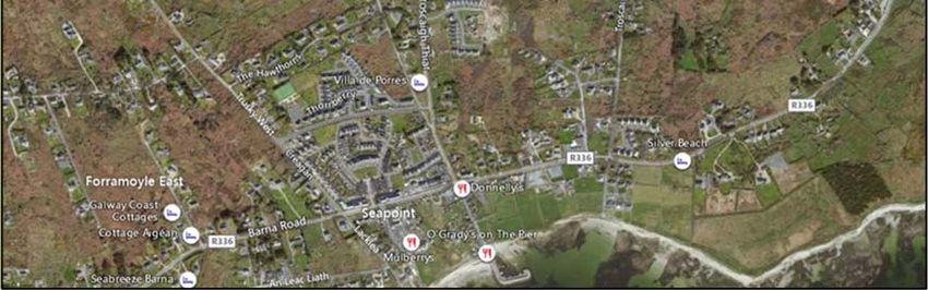
The application site is located in Bearna, a coastal village, approximately 6 kilometres to the west of
Galway City. The application site is situated in the townlands of Trusky East, Trusky West, Freeport
and Ahaglugger, Bearna, Co. Galway. The site is accessed via an existing residential development at
Trusky East, called Cnoc Fraoigh. The application site measures approximately 5.38 hectares in area.
The west of the site is the existing development of Cnoc Fraoigh which connects the site to the
Moycullen Road linking to the Village of Bearna and the R336 Galway City to Spiddal Road. A series
of ribbon development sites to the north of Cnoc Fraoigh bound the site and the remaining lands to the
north and east are agricultural lands. To the south are lands zoned ‘Open Space/Recreation &
Amenity’. The immediate vicinity consists of primarily suburban single family housing developments
with the nucleus of the village of Bearna located 0.45km from the proposed development.
Plate 2-1 Site Location – Aerial (Source – Bing Maps). Application Site outlined in Red (Indicative only)
2.1.2 Physical Characteristics of Site and Surrounding
Lands
The total application site area is approximately 5.38 Ha with a net site area of 3.47 Ha which refers to
the lands zoned for residential development.
The site is currently formed of scrub land and rough agricultural grazing and the lands are generally
bounded to the north and south by existing stone walls. The application site incorporates existing
features of significance which are being incorporated into the proposed scheme. The western boundary
2-1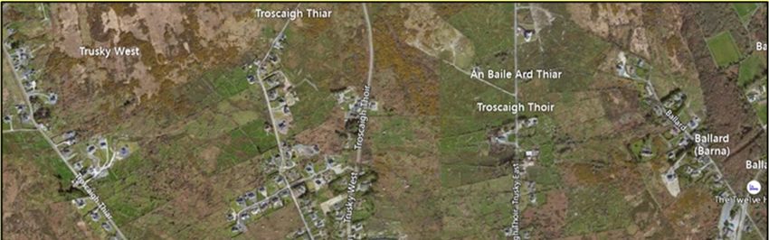
Burkeway Bearna Strategic Housing Development EIAR
                                                                                              EIAR - F – 2020.10.16 – 190450-a

        is generally defined by a 2-metre-high block wall to the rear of the existing dwellings at Cnoc Fraoigh
        and to the north west by native stone walls. The Trusky East Stream runs in a north-south direction to
        the east of the site.

        The site of the proposed development is partially within Indicative Flood Zones A&B and partially
        within Indicative Flood Zone C, by reference to the Flood Risk Map provided under Variation No.2(a)
        to the Galway County Development Plan 2015-2021 (“the Bearna Plan”). All proposed buildings will be
        located within Flood Zone C. There are no protected structures or archaeological monuments located
        within the application site. The Trusky stream is located within the eastern boundary of the site
        boundary. The application site is located 1.5km from the nearest European sites, namely, Galway Bay
        Complex candidate Special Area of Conservation (cSAC) (Site Code: 000268) and 1.5 km from the
        Inner Galway Bay Special Protection Area (SPA) (Site Code: 004031).

2.1.3   Site Access
        The development site is accessed via the existing access to Cnoc Fraoigh development (located to the
        West of the development site). The Cnoc Fraoigh development itself is accessed from the Moycullen
        Road (L1321) linking to the Village of Bearna and the R336 Galway City to Spiddal Road) to the south.

2.2     Planning History
        This section sets out the relevant planning history of the site and its immediate surrounds.

2.2.1   Planning Applications within the Application
        Boundary
        There is an extensive planning history associated with the site as summarised below. An overview of
        these applications is provided below.

2.2.2   Previous Strategic Housing Development (SHD)
        Applications
        There have been 2 no. previous SHD applications on lands within the site boundary of the proposed
        development as outlined below.

        Planning Reference ABP-300009-17

        Burkeway Homes Ltd., applied for planning permission to develop a Strategic Housing Development
        scheme comprising 113 no. residential units, community room, new vehicular and pedestrian access at
        Trusky East, Barna, Co. Galway.

        On 6th February 2018, An Bord Pleanála refused planning permission for the development. In their
        direction, the Board considered that the “density of the proposed development was contrary to the
        provisions of the Guidelines for Planning Authorities on Sustainable Residential Development in Urban
        Areas (2009), which was not considered to be developed at a sufficiently high density to provide for an
        acceptable efficiency in serviceable land usage given the proximity of the site to the built-up area of
        Beama and Galway City”. Furthermore, it was considered that the “development as proposed did not
        have an adequate mix of dwelling types, being predominantly semi-detached and detached housing”.

        The full reason for refusal is outlined below:

                 ‘’The Board considers that the density of the proposed development is contrary to the
                 provisions of the Guidelines for Planning Authorities on Sustainable Residential Development
                                                                                                                           2-2
Burkeway Bearna Strategic Housing Development EIAR
                                                                                      EIAR - F – 2020.10.16 – 190450-a

        in Urban Areas (2009), issued to planning authorities under section 28 of the Planning and
        Development Act. The site of the proposed development is on serviceable lands, within the
        development boundary of Bearna, in an area earmarked for Phase 1 residential development
        and within the Galway Metropolitan Area as designated in the settlement strategy for the
        county. Having regard to the proposed density of development, it is considered that the
        proposed development would not be developed at a sufficiently high density to provide for an
        acceptable efficiency in serviceable land usage given the proximity of the site to the built-up
        area of Bearna and Galway City and to the established social and community services in the
        immediate vicinity. In addition, the proposed development does not have an adequate mix of
        dwelling types, being predominantly semi-detached and detached housing. It is considered
        that the low density proposed would be contrary to the aforementioned Ministerial Guidelines,
        which indicate that net densities less than 30 dwellings per hectare should generally be
        discouraged in the interests of land efficiency. The proposed development would, therefore,
        be contrary to the proper planning and sustainable development of the area.’’

The current proposal has been designed to address the concerns of An Bord Pleanála in relation to
density and housing mix type.

Planning Reference ABP-302216-18

On the 31st July 2018 Burkeway Homes Ltd., submitted an application to develop a Strategic Housing
Development scheme comprising an increased dense scheme of 197 no. residential units, community
room, new vehicular and pedestrian access at Trusky East, Barna, Co. Galway. An Bord Pleanála
granted permission for the proposed development on the 16th November 2018.

The Board concluded as follows:

        “It is considered that, subject to compliance with the conditions set out below, the proposed
        development would represent an appropriate density of residential development having regard
        to the location of the site close to the centre of Bearna, would not seriously injure the
        residential or visual amenities of the area or of property in the vicinity, would not lead to a risk
        of flooding and would be acceptable in terms of pedestrian and traffic safety and convenience.
        The proposed development would, therefore, be in accordance with the proper planning and
        sustainable development of the area.”

        Appropriate Assessment Screening

        The Board noted the Statement of Screening for Appropriate Assessment submitted by the
        applicant and the Appropriate Assessment Screening determination carried out by the
        Inspector. In completing the screening for Appropriate Assessment, the Board accepted and
        adopted the screening determination carried out in the Inspector’s report in respect of the
        identification of the European sites which could potentially be affected, and the identification
        and assessment of the potential likely significant effects of the proposed development, either
        individually or in combination with other plans or projects, on those European sites in view of
        the sites’ conservation objectives.

        The Board was satisfied that the proposed development, either individually or in combination
        with other plans or projects, would not be likely to have a significant effect on European sites
        Galway Bay Complex Special Area of Conservation (site code 000268) and Inner Galway Bay
        Special Protection Area (site code 004031), or any other European site, in view of the sites’
        conservation objectives, and a Stage 2 Appropriate Assessment is not therefore required.

        Environmental Impact Assessment Screening

        The Board completed an environmental impact assessment in relation to the proposed
        development, taking into account the nature, scale and extent of the proposed development
                                                                                                                   2-3
Burkeway Bearna Strategic Housing Development EIAR
                                                                                              EIAR - F – 2020.10.16 – 190450-a

                 and concluded that the effects on the environment of the proposed development by itself and
                 in combination with other development in the vicinity would be acceptable.”

        However, the decision was subsequently subject to Judicial Review proceedings and by way of
        Judgment delivered on 21st June 2019, the High Court held that the decision made by the Board to
        grant permission would be set aside on, inter alia, the following grounds:

            1.   the (then) proposed development comprised a material contravention of the Galway County
                 Development Plan 2015 – 2021 (as varied) (GCDP), on the basis that the population allocation
                 in the GCDP allocated a figure of 420 no. persons/130 no. residential units to Bearna but the
                 proposed development was for 197 no. residential units. The Court noted that, notwithstanding
                 the material contravention, the Board could have granted permission by reference to the
                 criteria set out in section 37(2)(b) of the Planning and Development Act 2000 (as amended)
                 (pursuant to section 9(6)(c) of the Planning and Development (Housing) and Residential
                 Tenancies Act 2016, however, the Board did not do so;

            2.   the (then) proposed development comprised a material contravention of the GCDP on the
                 basis that Objective CCF6 made the “development management justification test” mandatory
                 in respect of the proposal, in addition to the obligation to comply with the Flood Risk
                 Management Guidelines;

            3.   in carrying out a Stage One Screening for Appropriate Assessment in respect of the (then)
                 proposed development, the Board relied on a commitment to comply with “best practice
                 measures” during construction in order to minimise any emissions into the Trusky Stream,
                 which was identified as being a potential pathway to the Special Protection Area (SPA) and
                 candidate Special Area of Conservation (cSAC) in Galway Bay. The Court held that the
                 screening determination was invalid in that it improperly relied on “best practice measures” in
                 reaching a screening determination.

        The High Court quashed the Board's decision to grant permission for the previously proposed
        development. The current application has been prepared having regard to the Judgment of the High
        Court and the current application addresses the grounds on which the previous decision was quashed.
        In particular, and notwithstanding the compliance of the proposed development with many policies and
        objectives of the GCDP, a Material Contravention Statement has been submitted with this application,
        in relation to the small number of policies and objectives of the GCDP which are materially
        contravened by the proposed development and demonstrates the manner in which a number of
        criteria in section 37(2)(b) of the 2000 Act are met, thereby enabling the Board to validly grant
        permission pursuant to section 9(6)(c) of the 2016 Act. Secondly, the application is accompanied by an
        Site Specific Flood Risk Assessment, which demonstrates the manner in which the criteria of the
        development management justification test are met in respect of the proposed development. The
        proposed development complies with the various land-use zoning objectives for the site. Third, no
        mitigation measures have been relied upon in the Appropriate Assessment Screening Report submitted
        with this application and a Natura Impact Statement has, in fact, been submitted with this application to
        enable An Bord Pleanála, as competent authority, to carry out a Stage Two Appropriate Assessment in
        respect of the proposed development.

2.2.3   Other Planning Applications within the Vicinity of the
        Application Site
        Table 2-1 below provides a list of the other relevant planning applications which relate to the subject
        lands and adjacent residential development, and has been compiled following a review of Galway
        County Council’s Planning Register in respect of the subject lands:

                                                                                                                           2-4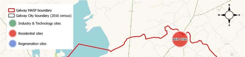
Burkeway Bearna Strategic Housing Development EIAR
                                                                                                  EIAR - F – 2020.10.16 – 190450-a

Table 2-1: Planning History within the Vicinity of the Application Site.
 Planning Reference Number                   Area SQM              Development                  Decision
                                                                   Description
 03/4315                                     C&T                   Application for the          Granted
                                             Development           demolition of existing
                                             Ltd.                  dwelling, construction
                                                                   of 22 no. 2 storey
                                                                   dwellings with
                                                                   treatment plant and
                                                                   associated site works
 04/3846                                     C&T                   Application for              Granted
                                             Developments          replacing two storey
                                             Ltd                   semi- detached
                                                                   dwellings with 5 no.
                                                                   detached two storey
                                                                   dwellings, revised
                                                                   boundaries/driveways
                                                                   to sites 9 to 16 and
                                                                   associated external
                                                                   works (gross floor
                                                                   space 5320sqm)
 04/4249                                     C&T                   Application for              Refused
                                             Developments          construction of 15 no.
                                             Ltd                   two storey dwellings
                                                                   and associated external
                                                                   works at previously
                                                                   granted residential
                                                                   development (03/4315)
 06/903                                      C&T                   Application to relocate      Granted
                                             Developments          a wastewater treatment
                                                                   system (originally
                                                                   granted under planning
                                                                   permission no's 03/4315
                                                                   and 04/3846)
 09/1278                                     Liam O'Toole          Application for the          Granted by Galway
                                                                   demolition of 3 No.          County Council but
                                                                   sheds/outbuildings, the      refused by An Bord
                                                                   construction of 94 No.       Pleanála (under
                                                                   dwellings comprising         reference no Pl. 07.
                                                                   of; 54 No. two storey        236240),
                                                                   semi-detached units, 20
                                                                   No. two storey terrace
                                                                   units comprising of 5
                                                                   No. terrace blocks, 16
                                                                   No. two storey
                                                                   detached units, 4 No.
                                                                   bungalow units, 3 No.
                                                                   two and a half storey
                                                                   buildings comprising of
                                                                   5 No. commercial/retail
                                                                   units, 10 No.
                                                                   apartments and a
                                                                   creche, the provision of
                                                                   parking and ancillary
                                                                   delivery areas, the
                                                                   construction of 3 No.
                                                                                                                               2-5
Burkeway Bearna Strategic Housing Development EIAR
EIAR - F – 2020.10.16 – 190450-a
link bridges, 4 No.
ancillary storage area
As can be seen from the above summary of planning history, there are a total of 7 no. separate relevant
planning applications associated with the subject lands and the adjacent residential development. The
existing Cnoc Fraoigh houses were developed under the terms of Pl. Ref. Nos. 03/4315 and 04/3846
and, in addition, the waste water treatment arrangements permitted under Pl. Ref. No. 06/903.
Permission was refused for a large proposal for 96 no. dwellings (incl. commercial/ retail development)
on part of the current application site including lands to the east under Pl. Ref. 09/1278 and An Bord
Pleanála Ref. no: PL 07.236240. A decision to grant permission was initially made by Galway County
Council (subject to 31 no. conditions), however, this decision was the subject of a successful third party
appeal and the sole reason for refusal given by the Board for refusing permission related to sewerage
capacity.
In relation to the proposed SHD, the current design team has engaged in consultations with Irish
Water, which has confirmed that there is sufficient capacity currently available in the network to
accommodate waste water from the proposed development.
2.3 National Planning Policy
This section of the report sets out the relevant national, regional and local planning policies and
objectives of relevance to the planning application.
2.3.1 National Planning Policy Context
2.3.2 Planning Policy Statement 2015
The Department of Environment, Community and Local Government’s (DECLG) Planning Policy
Statement 2015 encourages planning authorities to engage in active land management by leading and
managing the development process and ensuring that land zoned for development actually comes into
use in accordance with Development Plan policy and in tandem with supporting infrastructure. The
policy statement acknowledges that creating a consolidated urban form fosters the development of
compact neighbourhoods and a critical mass which contributes to the viability of economic, social, and
transport infrastructure. A key priority outlined in Planning Policy Statement is the development of a
new national planning framework which will provide the context for national spatial planning for the
next decade and beyond.
2.3.3 National Planning Framework
In 2018, the Government of Ireland adopted the National Planning Framework (NPF) entitled Ireland
2040 to succeed the National Spatial Strategy. The NPF comprises the Government’s proposed long-
term strategic planning framework to guide national, regional and local planning and investment
decisions over the next 25 years. It is intended that the NPF will be a strategic document that will
provide the framework for future development and investment in Ireland, providing a long-term and
place-based aspect to public policy and investment, and aiming to coordinate sectoral areas such as
housing, jobs, transport, education, health, environment, energy and communications, into an overall
coherent strategy. The NPF has a number of national policy objectives that articulate delivering on a
compact urban growth programme and are relevant to the Board’s consideration of the proposed
Strategic Housing Development. These include:
National Policy Objective (NPO) 1 (b) relating to population growth in the region;
National Policy Objectives (NPO) 2(a) relating to growth in our cities;
NPO 4 relating to attractive, well-designed liveable neighbourhoods;
2-6Burkeway Bearna Strategic Housing Development EIAR
EIAR - F – 2020.10.16 – 190450-a
NPO 5 relating to sufficient scale and quality of urban development; and
NPO 6 relating to increased residential population and employment in urban areas.
National Policy Objective 1b states in the context of population growth to 2040:
‘Northern & Western Region – population growth of 180,000 additional people.’
There is a very significant population growth allocated to the Northern & Western Region in which
Galway is the main urban centre. In order to facilitate this population growth there will be a requirement
to develop large numbers of new houses and apartments, approx. 20,000 units based on a standard
household size of 2.7 people. Given that Galway is currently acutely affected by the housing crisis there
is a considerable divide to be bridged in order to bring housing provision from its current under-supply
to the level required to accommodate the population growth forecasts. However, it is important that more
sustainable development patterns are established in order to facilitate targeted services and infrastructure
investment. The proposed development will deliver 121 no. residential homes and these homes would
be developed in accordance with the aspirations described above.
Please refer to Section 5.1.2 of the Planning Report and Statement of Consistency for further details on
the proposed developments compliance with the National Planning Framework.
2.3.4 Design Manual for Urban Roads and Streets (DMURS)
(2013)
The Design Manual for Urban Roads and Streets (DMURS), 2013, sets out design guidance and
standards for constructing new and reconfiguring existing urban roads and streets in Ireland. DMURS
aims to end the practice of designing streets as traffic corridors, and instead focus on the needs of
pedestrians, cyclists, and public transport users. DMURS notes that permeable layouts provide more
frequent junctions which have a traffic calming effect as drivers slow and show greater levels of caution.
The primary objectives of DMURS are as follows:
i. Prioritise pedestrians and cyclists in urban settings without unduly compromising vehicular
movement.
ii. Provide good pedestrian permeability and connectivity in urban environments in order to
encourage walking.
iii. Implement speed reduction measures to provide safe interaction between pedestrians, cyclists
and motorists.
iv. Create attractive streetscapes through the design of roads and footpaths with careful
consideration given to landscaping and selection of surface finishes.
Please refer to Section 5.1.3 of the Planning Report and Statement of Consistency for further details on
the proposed developments compliance with the Design Manual for Urban Roads and Streets.
2.3.5 Summary of Compliance with National Planning Policy
Table 2-2: Summary of Compliance with National Planning Policy
Compliance with National Planning Policy
The National Planning Framework has a number of directly relevant national policy objectives that
articulate delivering on a compact urban growth programme. The proposed development is
consistent with the Government’s Planning Policy Statement 2015 and national housing policy
generally.
The proposed development complies with the following NPF Policy Objectives;
2-7Burkeway Bearna Strategic Housing Development EIAR
EIAR - F – 2020.10.16 – 190450-a
National Policy Objective 2a: A target of half (50%) of future population and employment
growth will be focused in the existing five cities and their suburbs’
National Policy Objective 3a: Deliver at least 40% of all new homes nationally, within the built-
up footprint of existing settlement.
National Policy Objective 3b: Deliver at least half (50%) of all new homes that are targeted in
the five Cities and suburbs of Dublin, Cork, Limerick, Galway and Waterford, within their
existing built-up footprints
Galway City and Suburbs are identified as accommodating up to 90,000 additional people which
would equate in excess of 19,500 new dwellings with the GMA up to the year 2040. The proposed
development provides for 121 no. residential units and provides a significant response to Galway’s
housing needs in accordance with the population targets set out in the NPF.
National Policy Objective (NPO) 35 specifically articulates the delivery of higher density residential
developments across the county. The proposed development represents an efficient use of land in
the context of residential density and it is considered that it accords with the requirements to deliver
new residential development in a sustainable manner within the existing urban footprint.
The proposed development has been assessed for compliance with the Design Manual for Urban
Roads and Streets published by the Department of Transport, Tourism and Sport & the Department
of Environment, Community and Local Government. The proposed development provides for a
high level of accessibility and permeability ensuring ease of circulation throughout the scheme
Accordingly, this Report demonstrates that the proposed scheme is in accordance with the planning
policy objectives set out above.
2.4 Section 28 Ministerial Guidelines
There are various Ministerial Guidelines in respect of residential development, with those most relevant
to the proposed development included below.
2.4.1 Urban Development and Building Heights Guidelines
for Planning Authorities (December 2018)
The Guidelines states that generic maximum height limits, if inflexibly or unreasonably applied, can
undermine wider national policy objectives to provide more compact forms of urban development as
outlined in the National Planning Framework, and instead continue an unsustainable pattern of
development whereby cities and towns continue to grow outwards rather than consolidating and
strengthening the existing built up area. Furthermore, the Guidelines provide that blanket limitations
can also hinder innovation in urban design and architecture leading to poor planning outcomes.
Please refer to Section 5.2.1 of the Planning Report and Statement of Consistency for further details on
the proposed developments compliance with the Urban Development and Building Heights Guidelines
for Planning Authorities.
2.4.2 Sustainable Urban Housing: Design Standards for New
Apartments Guidelines for Planning Authorities 2018
The Sustainable Urban Housing: Design Standards for New Apartments (2018) update previous
guidance in the context of greater evidence and knowledge of current and likely future housing
demand in Ireland taking account of the Housing Agency National Statement on Housing Demand and
Supply, the Government’s action programme on housing and homelessness Rebuilding Ireland and
Project Ireland 2040 and the National Planning Framework, published since the 2015 guidelines.
2-8Burkeway Bearna Strategic Housing Development EIAR
EIAR - F – 2020.10.16 – 190450-a
Section 2.4 of the Guidelines identifies the types of location in cities and towns that may be suitable for
apartment development. In relation to ‘Peripheral and/or Less Accessible Urban Locations’ the
Guidelines state:
‘Such locations are generally suitable for limited, very small-scale (will vary subject to location),
higher density development that may wholly comprise apartments, or residential development
of any scale that will include a minority of apartments at low-medium densities (will also vary,
but broadlyBurkeway Bearna Strategic Housing Development EIAR
EIAR - F – 2020.10.16 – 190450-a
The subject site is classified as an ‘Outer Suburban/Greenfield’ site associated with cities and larger towns,
with a density in the general range of 35-50 dwellings per hectare as per Section 5.11 of the guidelines.
The development has a development density of 35 units per hectare.
Please refer to Section 5.2.3 of the Planning Report and Statement of Consistency for further details on
the proposed developments compliance with the Guidelines for Planning Authorities on Sustainable
Residential Development in Urban Areas.
2.4.4 Childcare Facilities - Guidelines for Planning
Authorities (2001)
In all new housing areas over 75 units, the provision of one childcare facility with a minimum of 20
childcare spaces is required, in line with the Ministerial Guidelines for Planning Authorities on
Childcare Facilities (DECLG 2001) and to create sustainable residential neighbourhoods. With regard
to larger housing developments, Section 2.4 of the guidelines state planning authorities should require
the provision of at least one childcare facility for new housing areas unless there are significant reasons
to the contrary. Appendix I of the Guidelines sets out general standards and minimum floors areas for
proposed childcare facilities.
The proposed scheme includes a childcare facility which extends to 224.8 sqm that can cater for 38 no.
children. The childcare facility is designed to comply with the Childcare Facilities – Guidelines for
Planning Authorities.
Please refer to Section 5.2.4 of the Planning Report and Statement of Consistency for further details on
the proposed developments compliance with the Childcare Facilities - Guidelines for Planning
Authorities.
2.4.5 The Planning System And Flood Risk Management,
Guidelines For Planning Authorities (2009)
The Planning System and Flood Risk Management Guidelines were issued by the Minister of the
Environment, Heritage and Local Government under Section 28 of the Planning and Development Act
2000.
A Flood Study of the Trusky Steam and a Site Specific Flood Risk Assessment have been prepared in
relation to the proposed development by O’Connor Sutton Cronin & Associates in accordance with the
Flood Risk Management Guidelines and are submitted with this application.
The Trusky East Flood Study provides a hydrological assessment of the stream catchment, while the Site
Specific Flood Risk Assessment demonstrates how the criteria of the Development Management
Justification Test are met in respect of the proposed development.
The SSFRA concludes at paragraphs 6.1.7 to 6.1.10 that: tidal/coastal flooding risk is not present at the
subject site; the provision of a robust drainage network and the design of roads to provide overland
flow routes away from existing and proposed buildings, will mitigate the risk of pluvial flooding; the
flood risks arising from the proposed drainage infrastructure will be negligible and no further mitigation
is required; and the flood risk represented by ground water is negligible and no further mitigation is
required.
Please refer to Section 5.2.5 of the Planning Report and Statement of Consistency for further details on
the proposed developments compliance with the Planning System And Flood Risk Management,
Guidelines For Planning Authorities.
2-10Burkeway Bearna Strategic Housing Development EIAR
EIAR - F – 2020.10.16 – 190450-a
2.4.6 Summary of Compliance with Section 28 Ministerial
Guidelines
Table 2-3: Summary of Compliance with Section 28 Ministerial Guidelines
Compliance with Ministerial Guidelines
The proposed development has been informed by the foregoing Guidelines and the proposed
development incorporates the relevant policies and objectives as contained therein. Accordingly, the
proposed development is consistent with the policies and objectives of the Ministerial Guidelines
outlined above.
The Guidelines for Planning Authorities on Sustainable Residential Development in Urban Areas
(May 2009) sets out the planning objectives for sustainable neighbourhoods under four main themes,
namely, provision of community facilities, efficient use of resources, amenity or quality of life issues
and conservation of the built and natural environment.
The guidelines state that net residential densities in the general range of 35-50 dwellings per hectare,
involving a variety of housing types where possible, should be encouraged generally at these sites. In
addition, the guidelines generally discourage densities of less than 30 dwellings per hectare in the
interests of land efficiency, particularly on sites in excess of 0.5 hectares.
The proposed development has a development net density of 35 units per hectare based on a net
site area of the 3.47ha of lands zoned for residential development. A variety of dwellings types and
unit size types are also proposed as outlined in the tables below. The proposed development
therefore complies with the ‘Guidelines for Planning Authorities on Sustainable Residential
Development in Urban Areas’ (May 2009).
The Urban Development and Building Heights Guidelines for Planning Authorities (December
2018) state that generic maximum height limits, if inflexibly or unreasonably applied, can undermine
wider national policy objectives to provide more compact forms of urban development as outlined in
the National Planning Framework, and instead continue an unsustainable pattern of development
whereby cities and towns continue to grow outwards rather than consolidating and strengthening the
existing built up area
The proposed development must be viewed in the context of its role in supporting the Galway City
and the Galway Metropolitan Area and therefore the design team has sought to ensure that higher
densities are achieved through the inclusion of 3-storey Apartment blocks and 3 storey Duplex
Blocks.
The 2018 guidelines outline a number of Specific Planning Policy Requirements. Specific Planning
Policy Requirement (SPPR) 4 is outlined below:
‘’SPPR 4 - It is a specific planning policy requirement that in planning the future
development of greenfield or edge of city/town locations for housing purposes, planning
authorities must secure:
1. the minimum densities for such locations set out in the Guidelines issued by
the Minister under Section 28 of the Planning and Development Act 2000 (as
amended), titled “Residential Development in Urban Areas (2007)” or any
amending or replacement Guidelines;
2. a greater mix of building heights and typologies in planning for the future
development of suburban locations; and
3. avoid mono-type building typologies (e.g. two storey or own-door houses
only), particularly, but not exclusively so in any one development of 100 units
or more’’
2-11Burkeway Bearna Strategic Housing Development EIAR
EIAR - F – 2020.10.16 – 190450-a
The site of the proposed development is a greenfield site and, accordingly, the Board (as a “planning
authority” for the purposes of the Guidelines”) must secure the three objectives identified in SPPR4.
Firstly, under Section 5.11 of the guidelines on Sustainable Residential Development in Urban Areas
(2009), the subject site is classified as an ‘Outer Suburban/Greenfield’ site associated with cities and
larger towns. The 2009 guidelines encourage densities in the general range of 35-50 dwellings per
hectare and discourage densities of less than 30 dwellings per hectare at these sites.
The development has a development density of 35 units per hectare. This density can be justified
due to the location of the site within the established settlement of Bearna, and also being within the
Galway Metropolitan Area.
The proposed development, secondly, provides a mix of building heights, units and sizes and,
thirdly, seeks to avoid mono-type building typologies.
The Sustainable Urban Housing: Design Standards for New Apartments Guidelines for Planning
Authorities (March 2018) update previous guidance in the context of greater evidence and
knowledge of current and likely future housing demand in Ireland taking account of the Housing
Agency National Statement on Housing Demand and Supply, the Government’s action programme
on housing and homelessness Rebuilding Ireland and Project Ireland 2040 and the National
Planning Framework, published since the 2015 guidelines.
The proposed residential scheme provides 121 no. residential units on an area of land zoned for
residential development which extends to a nett site of 3.47ha which equates to a residential density
of 35 units per hectare. In terms of density, the proposed scheme is considered to comply with the
national policy objectives set out in Section 2.4 of the Guidelines which promotes low to medium
density development on sites in suburban development areas that do not meet proximity or
accessibility criteria. The proposed scheme is also considered to comply with Section 2.5 of the
Guidelines which promotes the provision of apartments as they allow for greater diversity in the
housing scheme, whilst also increasing overall density. The provision of apartments contributes to the
mix of housing types proposed.
The proposed scheme includes a childcare facility which extends to 224.8 sqm that can cater for 38
no. children in line with the Childcare Facilities – Guidelines for Planning Authorities which requires
the provision of one childcare facility with a minimum of 20 childcare spaces in all new housing
areas over 75 units. The childcare facility is designed to comply with the Childcare Facilities –
Guidelines for Planning Authorities.
2.5 Regional Planning Policy Context
2.5.1 Regional Spatial and Economic Strategy (Northern &
Western Regional Assembly) 2020-2032
The Regional Spatial & Economic Strategy for the Northern & Western Regional Assembly (RSES
NWRA) was adopted on 24th January 2020. The principal purpose of the RSES is to support the
implementation of the National Planning Framework and the economic policies and objectives of the
Government by providing a long-term strategic planning and economic framework for the development
of the regions. Section 3.6 of the RSES sets out the Galway Metropolitan Area Strategic Plan (MASP).
The Vision of this MASP is that Galway will be a leading global city, renowned as a successful,
sustainable, competitive, compact and accessible city of scale that supports a high quality of life,
maintains its distinctive identity and supports its rich heritage, language and cultural experience.
2-12Burkeway Bearna Strategic Housing Development EIAR
EIAR - F – 2020.10.16 – 190450-a
The RSES outlines arrangements for a co-ordinated metropolitan area strategic plan (MASP) for the
Galway Metropolitan Area. The MASP has been provided with statutory underpinning to act as 12-year
strategic planning and investment framework. The MASP is an opportunity for Galway to address
recent growth legacy issues and build on key strengths, including a vibrant arts and cultural scene, year-
round tourism and an attractive natural setting.
A number of strategic locations have been identified that present the opportunity and capacity to
deliver the necessary quantum of housing to facilitate targeted growth. These strategic locations are
summarised on page 53 of the RSES (and set out below) and it is noted that Bearna is specifically
referred to in this context:
“> Consolidation of the existing neighbourhoods of Knocknacarra, Rahoon, Castlegar and
Roscam.
> Development of Regeneration Lands at Ceannt Station Quarter, Inner Harbour and
Headford Road
> Ardaun
> Murrough
> Baile Chláir, Bearna, Oranmore, Briarhill” [Emphasis added]
These strategic locations are also shown on Figure 21 on page 53 of the RSES (extracted below) which
identifies Bearna as having potential for residential sites.
Figure 2-1: Figure 21 extracted from RSES
The table on page 54 of the RSES identifies that the approximate land area designated for “Land
Capacity – Lands Available for Housing” in Bearna is 14 Ha.
Moreover, page 55 of the RSES states as follows in relation to Bearna:
“Bearna is located to the west of the Metropolitan Area, at the gateway to the Gaeltacht na
Gaillimhe (County Galway Gaeltacht). It has experienced significant growth in and
2-13Burkeway Bearna Strategic Housing Development EIAR
EIAR - F – 2020.10.16 – 190450-a
surrounding the village and is serviced through the Mutton Island Wastewater Treatment
Plant. Its location favours future growth that should have a focus that includes the
consolidation of built-up areas of the village and the provision of supporting community
infrastructure and services that are easily accessible by walking, cycling or public transport.
The built, archaeological and cultural heritage of Bearna are important assets that should be
conserved appropriately, including the Pier Road Architectural Conservation Area. While
there is currently circa 14ha of residential phase 1 lands identified in the Bearna Local Area
Plan that can accommodate growth in the short/medium term, there are additional lands
available to facilitate further growth. The identification of such lands shall be a matter for the
statutory plan-making process and shall have regard to environmental considerations,
including flood risk and climate change.”
The proposed development provides for 121 no. residential units and provides a significant response to
Galway’s housing needs in accordance with the population targets set out in the RSES.
Please refer to Section 5.3.1 of the Planning Report and Statement of Consistency for further details on
the proposed developments compliance with the Regional Spatial and Economic Strategy.
2.5.2 Summary of Compliance with Regional Planning
Policy
Table 2-4: Summary of Compliance with Regional Planning Policy
Compliance with Regional Planning Policy
The proposed development will provide 121 no. residential units, acting as a key compact growth
settlement, supporting the role of Bearna as a strategic location to facilitate targeted growth in the
Galway Metropolitan Area. The proposed scheme will provide a significant supply of mixed tenure
residential units which will contribute towards the aim to grow the population of the Galway MASP
by 38,001 by 2031.
2.6 Local Planning Policy Context
2.6.1 Galway County Development Plan 2015-2021
The overall development context of Bearna is set within the context of the County Development Plan
and the site is governed by the policies and provisions contained in the Galway County Development
Plan 2015-2021 (“the GCDP”). The GCDP was adopted by the Members of Galway County Council on
26th January 2015 and the Plan is effective from 23rd February 2015. The Galway County Development
Plan 2015-2021, including Chapter 2 thereof, was varied by Variation No.1 adopted on 24 April 2017. In
addition, on the 23rd July 2018, Variation No.2(a) to the Galway County Development Plan 2015-2021
was adopted by Galway County Council, which incorporated the Bearna Plan into the Galway County
Development Plan 2015-2021. The Gaeltacht Plan was also adopted as Variation No. 2(b) to the Galway
County Development Plan 2015-2021).
The current GCDP sets out an overall strategy for the proper planning and sustainable development of
the functional area of Galway County Council. Chapter 2 of the GCDP (as varied by Variation No. 1)
sets out the overarching Spatial Strategy of the County, references the development options considered
for the growth and details the preferred development option chosen. It details the Core Strategy and sets
out the application of regional population targets to the settlement hierarchy determined as part of the
Spatial Strategy.
2-14Burkeway Bearna Strategic Housing Development EIAR
EIAR - F – 2020.10.16 – 190450-a
The “Core Strategy Table: February 2015” at page 25 of the GCDP (as varied by Variation No. 1) includes
a list of all key towns and larger villages and provides a population growth allocation for each for the
period 2015 to 2021. The Core Strategy Table also includes an assessment of the quantum of residentially-
zoned land available to meet the population growth allocation. The Core Strategy Table indicates that
the core strategy population allocation for Bearna is 420 persons, with a land allocation of 12.12 hectares
provided to accommodate new residential development over the plan period and a housing units yield
on residential land of 130 units and an indicative density of 16 units.
The Core Strategy is an integral component of the Spatial Strategy. It transposes the population targets
for Galway set out in the Regional Planning Guidelines and allocates them throughout the County, which
in turn determines the Settlement Hierarchy and provides a rationale for the amount and location of land
proposed to be zoned. Bearna forms part of the Galway Metropolitan Area (GMA), which is on the first
tier in the Settlement Hierarchy. The GMA includes Galway City and a number of adjacent electoral
divisions that are deemed to be inextricably linked to and function as part of the Greater Galway City.
Objective Objective CS 2 – Development Consistent with the Core Strategy andObjective CS 8 – Core
Strategy and Demand for Development of the GCDP requires development to be consistent with the
core strategy.
A Material Contravention Statement is provided with this application (as it is considered that the proposed
development materially contravenes the Core Strategy in relation to the population allocation of 420
people, a housing yield of 130 units and an indicative density of 16 units in the Core Strategy Table on
page 25 of the GCDP. As outlined in detail in the Material Contravention Statement, in the light of the
High Court judgment, it is considered that there are conflicting objectives in the development plan that
relate to the proposed development. Specifically, Bearna’s position in the GMA conflicts with the
population allocation of 420 people, a housing yield of 130 units and an indicative density of 16 units in
the Core Strategy Table and the requirement in Objective CS 2 for development to be consistent with
the core strategy is in conflict with other objectives in the GCDP, including Objectives SS 1, UHO 10
and UHO 11.
Housing
With regard to the design of new housing developments within Galway County, the GCDP outlines the
following objectives:
Objective UHO 7 – High Quality/Mix and Sensitive Design
Objective UHO 8 – Urban Design
Objective UHO 10- Sequential Development
Objective UHO 11 – Development Densities
Objective UHO 2 – Social and Specialist Housing
The are several proposed house types, the design of which reflects the Galway vernacular aesthetic
through the use of materials, colours and detailing. The development seeks to respond to the topography
and features of the site and the existing grain of the built form surrounding the subject site.
The development complies with the plot area ratio control within the Bearna Plan. The proposed
development has a development density of 35 units per hectare when calculated based upon net
development area, which excludes the ‘Open Space Recreation and Amenity’ Zone which dissects the
subject site. The proposed development therefore complies with the Guidelines for Planning Authorities
on Sustainable Residential Development in Urban Areas’ (May 2009).
Discussions have taken place with the Housing Section of Galway County Council in November
2019 with a view towards reaching a Part V agreement for the proposed development. A letter
from the Galway County Council Housing section detailing discussions that have taken place,
together with the agreed approach to complying with Part V requirements, accompanied the
request for pre- planning discussions. The applicant proposes to provide the 12 no. units to fulfil
2-15Burkeway Bearna Strategic Housing Development EIAR
EIAR - F – 2020.10.16 – 190450-a
their 10% Part V obligation in accordance with Section 95 of the Planning & Development Act
2000 (as amended).
Linguistic Impact
In terms of linguistic impact, the GCDP contains the following objectives:
Objective UHO 12 – Linguistic Impact Statements
Objective UHO 13 – Urban Housing in Gaeltacht Settlements
A comprehensive Linguistic Impact Statement (LIS) was commissioned as part of the planning
application. Overall, it is not anticipated that the proposed development will have any undue
negative impact on the Irish language or the Irish culture in the village of Bearna.
Flood
The following objectives within the GCDP relate to flooding;
Objective DS 7 – Flood Risk Management and Assessment
Policy FL 4 – Principles of the Flood Risk Management Guidelines
Objective FL 3 – Protection of Waterbodies and Watercourses
Objective FL 4 – Flood Risk Assessment for Planning Applications and CFRAMS
Objective FL 5 – SFRA/FRA and Climate Change
Objective NHB 14 – Protection of Riparian Zones
In compliance with the above objectives and Flood Risk Management Guidelines, a Site-Specific
Flood Risk Assessment (SSFRA) and Trusky East Stream Flood Study have been prepared by
O’Connor Sutton Cronin Engineers. In particular, this SSFRA report demonstrates (i) the manner
in which the “Justification Test” has been applied on behalf of the developer and should be applied
by the Board and (ii) the criteria of that test are met in respect of the proposed development. The
SSFRA is a detailed Flood Risk Assessment, carried out in accordance with The Planning System
and Flood Risk Assessment Guidelines & Circular PL 2/2014, which assesses the risks of flooding
associated with the proposed development. The SSFRA also considers the impact of climate
change. The SSFRA demonstrates that the proposed development will not have adverse impacts
on the stream or floodplains. Measures proposed follow best practice in the management of health
and safety in relation to flood risk for users and residents of the development.
Further in compliance, the Trusky East Stream Flood Study report provides a hydrological
assessment of the stream catchment, the SSFRA report demonstrate the capacity to withstand
potential flood events and the Engineering Services Report includes a hydrological assessment of
the subject site and describes the SUDS design.
Objective NB14 also requires the protection of riparian zones of watercourse systems. The Trusky
Stream is located within the proposed development site boundary. The stream is separated from
the main construction footprint by over 10m at its nearest point. However, the construction works
also involve the discharge of surface water from the proposed development, to the Trusky Stream.
This involves, the installation of two precast headwalls within the banks of the stream at the location
of the two surface water outfalls. There will also be some minor landscaping works including the
planting of native species and the construction of a boundary fence along the stream banks to
ensure the safety of users undertaking recreational activities on the OS zoned lands. These minor
works will not affect the integrity of the riparian zone. A linear park with strong biodiversity focus
forms the eastern boundary of the site and separates the stream from proposed buildings and
roads.
2-16Burkeway Bearna Strategic Housing Development EIAR
EIAR - F – 2020.10.16 – 190450-a
Ecology
The following objectives within the GCDP relate to Natural Heritage and Biodiversity;
Objective DS 6 – Natura 2000 Network and Habitats Directive Assessment
Objective DS 9 –Projects/Associated Improvement Works/Infrastructure and Appropriate
Assessment
In compliance with Objective DS 6 and DS 9, ecological reports are submitted with this application,
including an Appropriate Assessment Screening Report and Natura Impact Statement to enable
the Board to carry out a Stage One Screening for Appropriate Assessment and a Stage Two
Appropriate Assessment.
Please refer to Section 5.4.1 of the Planning Report and Statement of Consistency for further details
on the proposed developments compliance with the Galway County Development Plan 2015-2021.
2.6.2 Variation No.2(a) to the Galway County Development
Plan 2015-2021 (Bearna Plan)
On the 23rd July 2018, Variation No.2(a) to the Galway County Development Plan 2015-2021 was adopted
by Galway County Council, which incorporated the “Bearna Plan” into the GCDP. Accordingly, the
proposed site is governed by the policies and objectives contained in the Bearna Plan.
The Bearna Plan is underpinned by a common vision to guide the future growth, development and
improvement of Bearna in a manner that is sustainable, achieves the overall objectives set for Bearna in
the Galway CDP, including the Core Strategy; and reflects the existing landscape, environment, heritage,
character and amenity of the village and that improves the quality of life of the local community.
Section 1.2 of the Bearna Plan outlines the following Strategic Vision for Bearna:
“To promote Bearna as a sustainable and vibrant coastal village, which maintains its
attractive character, capitalises on its existing and future accessibility strengths, while
offering a pleasant environment for a growing community, for living, shopping, education,
business, recreation and tourism, all balanced against the need to safeguard and enhance
the environmental sensitivities of the area, for present and future generations to come.”
The proposed scheme will provide a high quality residential development in the village of Bearna thus
further promoting Bearna as a sustainable coastal village for its growing community.
The Bearna Plan, at section 1.3, expressly references the population allocation in the core strategy:
“1.3 Settlement Hierarchy/Core Strategy
Bearna is located within the Galway Transportation and Planning Study (GTPS) area and is a
key settlement in the Galway Metropolitan Area, which is on the first tier in the settlement
hierarchy. A key component of the Bearna Plan is to ensure that it aligns with the Core
Strategy/Settlement Strategy, as set out in the Galway County Development Plan. The Core
Strategy indicates that Bearna has been assigned a population growth target of 420 persons by
2021 with a land allocation of 12.12 hectares provided to accommodate new residential
development over the plan period.
As noted above, a Material Contravention Statement is provided with this application as it is considered
that the proposed development materially contravenes this population allocation set out in the Core
Strategy in respect of Bearna.
2-17Burkeway Bearna Strategic Housing Development EIAR
EIAR - F – 2020.10.16 – 190450-a
In relation to building height, Objective UD2 of the Bearna Plan states:
Objective UD2 - New Buildings
‘’Building heights, widths and material finishes shall be in keeping with the character and scale
of existing development in the area and shall be appropriate to the locality, site context and
building function. A maximum building height of two and half storeys will generally apply but
reduced building heights will be required in visually vulnerable locations e.g. coastal side of
the road. Increased building heights may be considered in exceptional circumstances where
they contribute positively to the village character and design, subject to a high standard of
urban design and have no adverse impacts on amenity.’’
The proposed development includes 3-storey Apartment blocks and 3 storey Duplex Blocks, which is
marginally higher than the generally accepted maximum height of two and half storeys. However, in line
with Objective UD2, it is considered that the increased building height is provided in exceptional
circumstances, contributes positively to the village character, is of a high standard urban design and has
no adverse impacts on amenity and is therefore compliant. However, based on the fact that elements of
the proposed development are in excess of two and half storeys, it is acknowledged that the proposal
constitutes a material contravention of Objective UD2 in this regard.
Chapter 1.4.5 of the Bearna Plan outlines the following objectives relating to residential development:
Objective RD1 - Residential Development Phasing
Objective RD2 – Apartment Development
Objective RD3 - Quality Housing Environments
The proposed buildings are located on lands zoned as R – Residential (Phase 1). Phase 1 residential lands
have been identified for short to medium term growth in suitable locations that are serviceable and
accessible.
The design team has sought to ensure that higher densities are achieved, while also ensuring that the
open, residential character is maintained. In this regard, the development proposes a limited number of
apartment buildings located within the development. This approach ensures that potential issues of
overlooking, overshadowing and overbearing impact have been fully mitigated, thereby protecting the
residential amenity of neighbouring properties. Accordingly, the proposed location of apartment
development is considered to be acceptable.
The layout of the scheme has been designed to respect the existing routes, scale, height and amenity of
the Cnoc Fraoigh development reflect the existing lower density of adjoining developments. The layout
of the scheme has been designed to promote permeability and openness with a series of view corridors
allowing views through the site and across the proposed new landscape. These view corridors promote
passive surveillance of the site and allow visual connections to the variety of outdoor amenities provided
through the development. Generous footpaths and pedestrian/cycle routes feature throughout the scheme
as well as a number of pedestrian crossings.
The following objectives relate to amenity facilities;
Objective CF2 - Playground Facilities
Objective CF3 - Community, Recreation and Amenity Facilities
The development also includes the provision of 6711m2 shared open space, within a series of
landscaped areas throughout the development. This includes the provision of a playground, astro-turf
kickabout area, a putting green as well as designated seating areas. A multi-purpose room is proposed
for the residents of the scheme and is located on the ground floor of Apartment Block 2.
2-18Burkeway Bearna Strategic Housing Development EIAR
EIAR - F – 2020.10.16 – 190450-a
Section 1.4.7 of the Bearna Plan relates to Built Heritage and Natural Heritage and contains the
following objectives;
Objective BNH2 – Natural Heritage Areas and Proposed Natural Heritage Areas
Objective BNH3 – European Environmental Compliance
Objective BNH4 - Local Streams
In compliance with Objective BNH2 and BNH3, ecological reports are submitted with this
application, including an Appropriate Assessment Screening Report and Natura Impact Statement
to enable the Board to carry out a Stage One Screening for Appropriate Assessment and a Stage
Two Appropriate Assessment.
With regard to Objective BNH4, the Trusky Stream is located within the proposed development site
boundary. The stream is separated from the main construction footprint by over 10m at its nearest
point. However, the construction works also involve the discharge of surface water from the proposed
development, to the Trusky Stream. This involves, the installation of two precast headwalls within the
banks of the stream at the location of the two surface water outfalls. There will also be some minor
landscaping works including the planting of native species and the construction of a boundary fence
along the stream banks to ensure the safety of users undertaking recreational activities on the OS
zoned lands. These minor works will not affect the integrity of the riparian zone. A linear park with
strong biodiversity focus forms the eastern boundary of the site and separates the stream from
proposed buildings and roads.
Please refer to Section 5.4.2 of the Planning Report and Statement of Consistency for further details
on the proposed developments compliance with Variation No.2(a) to the Galway County
Development Plan 2015-2021 (Bearna Plan).
2.6.2.1 Compliance with Land-Use Zoning Objectives
On 23rd July 2018, Variation No.2(a) to the Galway County Development Plan 2015-2021 was adopted
by Galway County Council, which incorporated the Bearna Plan into the GCDP. Accordingly, the
proposed site is governed by the policies and provisions contained in the Bearna Plan. The Bearna Plan
includes: a Land Use Zoning Map for Bearna in section 5; associated Land Used Zoning Objectives;
and a Land Use Zoning Matrix, which indicates the land use classes that are (i) permitted in principle,
(ii) open for consideration, or (iii) not normally permitted in each of the land use zones, in section 4.
The proposed development comprises development of a greenfield site zoned ‘R’ and ‘OS’. The
residential development proposed on lands zoned R accords with the Phase 1 residential zoning and
‘Objective RD1 – Residential Development Phasing’, which requires that development be directed into
lands which are zoned and serviced. The proposed residential development on lands zone R complies
with the Land Use Zoning Matrix and Objective RD3. All proposed buildings will be located on lands
zoned Residential (Phase 1) that are not subject to ‘Objective CCF6 – Inappropriate Development on
Flood Zones’. The proposed development complies with Objective CCF6 as outlined above. In particular,
a Site Specific Flood Risk Assessment (SSFRA), which demonstrates how the criteria of the Development
Management Justification Test are met in relation to the proposed development and accompanying flood
study of the Trusky East Stream are submitted with this application. The proposed development also
includes public open space/linear park and 2 no. surface water drainage pipes on land zoned ‘OS’, which
lands are also subject to Constrained Land Use ‘CL’. These proposed land uses, namely recreational and
utilities infrastructure, are open for consideration on the Land Use Zoning Matrix and the proposals
comply with Objectives LU4, LU8 and DM Guideline FL1 as outlined above. Finally, the proposed
pedestrian link along the L1321 complies with the Land Use Zoning Matrix and Objectives LU6 and
RT2.
2-19You can also read