High Level Spatial Plan - Urban Form Scenarios for Western Bay of Plenty Sub-region Prepared for SmartGrowth 7 February 2020 - UFTI
←
→
Page content transcription
If your browser does not render page correctly, please read the page content below
High Level Spatial Plan
Urban Form Scenarios for Western Bay of Plenty Sub-region
                               Prepared for SmartGrowth

                                         7 February 2020
Document Quality Assurance

 Bibliographic reference for citation:
 Boffa Miskell Limited 2020. High Level Spatial Plan: Urban Form Scenarios for Western Bay
 of Plenty Sub-region. Report prepared by Boffa Miskell Limited for SmartGrowth.

 Prepared by:                       Craig Batchelar
                                    Planner/Partner
                                    Boffa Miskell Limited

 Reviewed by:                       Matt Allott
                                    Planner/Principal
                                    Boffa Miskell Limited

 PM Approved                for     Craig Batchelar
 release:                           Planner/Partner
                                    Boffa Miskell Limited

 Status: FINAL                      Revision / version: 1                           Issue date: 7 February 2020

 Use and Reliance
 This report has been prepared by Boffa Miskell Limited on the specific instructions of our Client. It is solely for our Client’s use for
 the purpose for which it is intended in accordance with the agreed scope of work. Boffa Miskell does not accept any liability or
 responsibility in relation to the use of this report contrary to the above, or to any person other than the Client. Any use or reliance
 by a third party is at that party's own risk. Where information has been supplied by the Client or obtained from other external sources,
 it has been assumed that it is accurate, without independent verification, unless otherwise indicated. No liability or responsibility is
 accepted by Boffa Miskell Limited for any errors or omissions to the extent that they arise from inaccurate information provided by
 the Client or any external source.

Template revision: 20190509 0000

File ref: High Level Spatial Plan 5.docx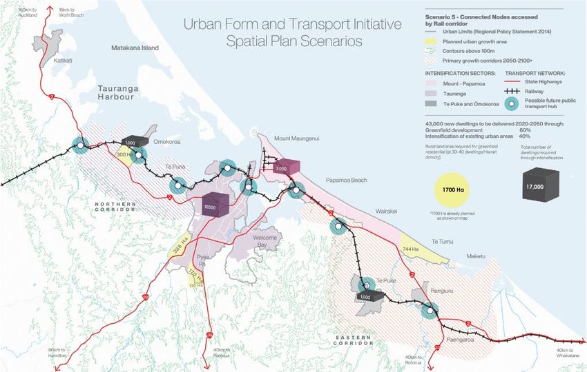
CONTENTS

1.0     Summary                                                                                  1

2.0     Introduction                                                                             2

3.0     Methodology                                                                              2

4.0     Spatial Planning                                                                         2

5.0     Context and Constraints                                                                  4

        5.1    Wāhi Toitū/Protection                                                             4
        5.2    Wāhi Toiora/Mitigation                                                            7
        5.3    Awarua                                                                            9
        5.4    Wāhi Mahi/Work Places                                                           10
        5.5    Wāhi Noho/Living Places                                                         12
        5.6    Whakamana/Infrastructure                                                        14

6.0     Urban Form Scenarios                                                                   14

        6.1    Method                                                                          14
        6.2    Base Case – Continuation of Status Quo                                          16
        6.3    Alternative Scenarios Suggested for Evaluation                                  17
        6.4    Excluded Scenarios                                                              20

7.0     Evaluation Framework                                                                   21

8.0     High Level Scenario Evaluation                                                         23

        8.1    Introduction                                                                    23
        8.2    Transitional Issues                                                             23
        8.3    30 Year Planning Horizon                                                        24
        8.4    100 Year Planning Horizon                                                       24
        8.5    Spatial Allocation for Additional Urban Capacity                                24
        8.6    Intensification Issues                                                          25
        8.7    Papakāinga                                                                      26
        8.8    Implementation Issues for Alternative Scenarios                                 26

U:\2019\BM19730_CBa_High_Level_Spatial_Plan\Documents\1_Context\High Level Spatial Plan Final.docx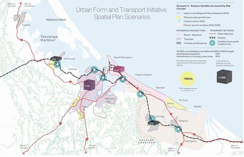
Appendices
Appendix 1: Context and Constraints

Appendix 2: Scenario Illustrations

Appendix 3: Scenario Spatial Allocations

Appendix 4: Evaluation Criteria

U:\2019\BM19730_CBa_High_Level_Spatial_Plan\Documents\1_Context\High Level Spatial Plan Final.docx
1.0 Summary
A revised collaborative Spatial Plan for the WBOP sub-region is being developed in accordance
with current best practice and the Government’s Urban Growth Agenda. This will allow the UFTI
partners to agree on a high-level preferred urban form.
This report is intended assist with defining the different scenarios for urban form (“building up” or
“building out’) within the sub-region. The high-level urban form scenarios outline land use
development options to support liveable communities in the western Bay of Plenty. A preferred
long-term urban form for the sub-region needs to be identified that provides for the projected
growth in population, housing, community facilities and employment while responding to the local
context and constraints.
The context and constraints for spatial planning include the natural and physical resources of the
subregion and the drivers of growth that create demand for and pressure on those resources.
Constraints maps have been developed showing the natural and physical resouces that will
influence long term spatial planning decisions. The constraints are categorised as either:

    •   Wāhi Toitū - places with enduring presence that should be protected from development
        in perpetuity, commonly referred to as “no go” areas

    •   Wāhi toiora - places where change or development can occur, but only with great care
        and where effects can be mitigated to an acceptable level
Strategic Transport and Blue/Green corridors (Awarua) are also identified. These are enduring
physical resources that strongly influence land use patterns, but are also affected by those land
uses.
Population and employment projections have been prepared to provide an understanding of the
scale of future growth that will need to be accommodated in the long term.
In the next 30 years the subregional population is expected to reach 270,000 people. This is
projected to equate to around 43,000 additional houses.
For high level spatial planning purposes it is prudent to use a high growth scenarios for the period
out to 100 years. The 100 year growth scenario for the western Bay of Plenty sub-region
population is assumed at 400,000 people – 200,000 additional people and 100,000 additional
houses.
Continuation of current development trends in the subregion (the “base case”) will, in the long
term result in a large and expanding urban footprint with poor outcomes for the protection of
productive rural land and landscape character and amenity, with high dependency on private
vehicles and associated energy consumption and carbon emissions
Alternative urban form scenarios have been developed as part of the process of identifying a
preferred urban form for the sub region from which a long term spatial plan can be developed.
The scenarios that have been developed are explorative, recognising the uncertainties that are
found in many of the drivers of growth. The urban form scenarios are not predictions of what will
happen but are simulations of what can happen.

                                     High Level Spatial Plan | Urban Form Scenarios for Western Bay of Plenty Sub-region   1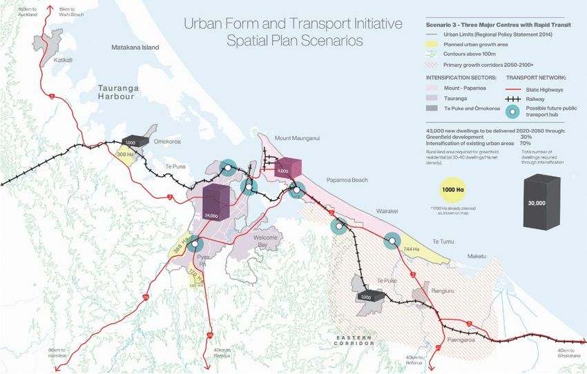
Six scenarios are suggested for evaluation:

    •   Scenario 1 – SmartGrowth Settlement Pattern

    •   Scenario 2 - Connected Nodes with Rapid Transit

    •   Scenario 3 - Three Major Centres with Rapid Transit

    •   Scenario 4 - Compact and Connected City with Rapid Transit

    •   Scenario 5 - Connected Nodes accessed by Rail corridor

    •   Scenario 6 - Eastern Satellite centre accessed by Rail corridor
The Scenarios allocate future growth in new areas within the identified SmartGrowth corridors
(east, west and north). Maps illustrate how the next 30 years of urban growth will be
accommodated, with corridors and transport hubs included to indicate where the longer-term
greenfield growth will go beyond 2050.
The allocation of population growth for each scenario is provisional, based on a high level
assessment of land use and transport relationships and the likely level of constraint to
development based on the need for protection or mitigation of effects on natural and physical
resources.
The framework for evaluating the urban form scenarios has taken into account a range of current
policy instruments to support a high level sustainability appraisal/strategic environmental
assessment.
The length of time it will take to transition to new urban form and transport outcomes will
significantly affect the ability to achieve the targeted shift toward intensification. The more
ambitious the density targets, the longer the transition period might be. This is a factor that should
be carefully taken into account in the later evaluation phases of the programme.
The initial evaluation is that in the very long term (50-100 year horizon), the urban footprint under
each of the alternative scenarios will need to expand. This is because the assumed capacity for
intensification can physically accommodate only 40%-50% of projected growth in the long term,
requiring further greenfield expansion to accommodate the excess demand under all scenarios.
Planning for increasing densities and yields in the planned greenfield areas should receive the
same early attention as intensification of existing urban areas.
There will be an important action for the second stage of work that spatial allocations of growth
to new areas be assessed further drawing together work completed to date and addressing any
information gaps.

                                      High Level Spatial Plan | Urban Form Scenarios for Western Bay of Plenty Sub-region   1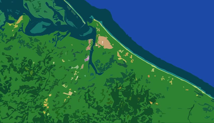
2.0 Introduction
    A revised collaborative Spatial Plan for the WBOP sub-region is being developed in accordance
    with current best practice and the Government’s Urban Growth Agenda. This will allow the UFTI
    partners to agree on a high-level preferred urban form.
    This report is intended assist with defining the different scenarios for urban form (“building up” or
    “building out”) within the sub-region. The scenarios extend out beyond the usual 30 year horizon
    to 50-100 years to gain some understanding of the longer term implications of the choices that
    may be made today.
    The high-level urban form scenarios outline land use development options to support liveable
    communities in the western Bay of Plenty. A preferred long-term urban form for the sub-region
    needs to be identified that provides for the projected growth in population, housing, community
    facilities and employment while responding to the local context and environmental constraints.

    3.0 Methodology
    Central Government has recently provided guidance on regional and sub-regional Spatial
    Planning best practice that it considers will work in the NZ context. Scenario development and
    evaluation follows a similar process to that currently being used for the Hamilton-Waikato Metro
    Spatial Plan.
    The methodology is as follows:
            1. Prepare baseline map layers (natural and physical constraints), and supporting factual
               information to inform scenrio development;
            2. Create a shortlist of high-level scenarios for changing urban form at the sub-region scale
               and supporting information to explain each option.
            3. Develop an evaluation framework that considers a range of relevant criteria drawn from
               current planning instruments;
            4. Carry out a high level evaluation of the scenarios to inform the evaluation and
               identification of a preferred urban form scenario.
    This report, along with other technical reports, will help identify aspects of the UFTI programmes
    where additional information is required.

    4.0 Spatial Planning
    Current Government’s policy intention is to have consistent spatial plans for all Major Urban
    Centres 1.

    1
        https://www.mfe.govt.nz/publications/towns-and-cities/planning-successful-cities-discussion-document-proposed-national

2   High Level Spatial Plan | Urban Form Scenarios for Western Bay of Plenty Sub-region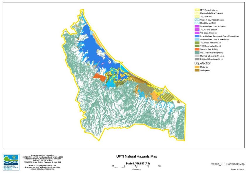
Spatial planning is about coordination and integration and considers economic, social and
environmental effects of development. Spatial plans set out the long term (100 year) spatial form
of an area and the priority development areas and priority infrastructure for the next 30 years.
Methods used for spatial planning include 2:

        •     Building an understanding of critical spatial development trends and drivers, market
              demands and needs, and the social, economic and environmental impacts of
              development;

        •     Generation of alternatives and options assisted by sustainability appraisal/strategic
              environmental assessment;

        •     Evaluation of alternatives and options through visioning and strategic choice approaches.
Spatial plans require a sound evidence base to ensure that decisions take into account the best
avaliable information.
The following layers, drawn from the Waikato Spatial Planning model, provide the foundation for
high level spatial planning in this assessment:

    Layer          Description                  Planning Horizon              Strategy                      Examples

    Layer 1        Wāhi Toitū                   The long term                 Protection                    “No go” areas that
                                                spatial frame                                               are not suitable for
                                                                              The places with
                                                                                                            development
                                                (100 years +)                 enduring presence
                                                                                                            including     rivers,
                                                                              that should be
                                                                                                            places             of
                                                                              protected    from
                                                                                                            significance       to
                                                                              development     in
                                                                                                            manawhenua,
                                                                              perpetuity.
                                                                                                            conservation estate
                                                                                                            and areas of high
                                                                                                            hazard risk that cant
                                                                                                            be mitigated.

    Layer 2        Wāhi toiora                                                Mitigation                    “Go     carefully   “
                                                                                                            areas for mitigating
                                                                              The places where
                                                                                                            impacts or restoring
                                                                              change         or
                                                                                                            environmental
                                                                              development
                                                                                                            qualities including
                                                                              should occur with
                                                                                                            land      that     is
                                                                              greatest care.
                                                                                                            susceptable       to
                                                                                                            flooding and rural
                                                                                                            land above 100m
                                                                                                            altitude

    Layer 3        Awarua                                                     Connections                   Railways,  roads,
                                                                                                            motorways.
                                                                              The     movement
                                                                              corridors that bind           Strategic transport
                                                                              places together               and       blue-green
                                                                                                            corridors

2
    https://www.mfe.govt.nz/publications/rma/building-competitive-cities-reform-urban-and-infrastructure-planning-system-1

                                                     High Level Spatial Plan | Urban Form Scenarios for Western Bay of Plenty Sub-region   3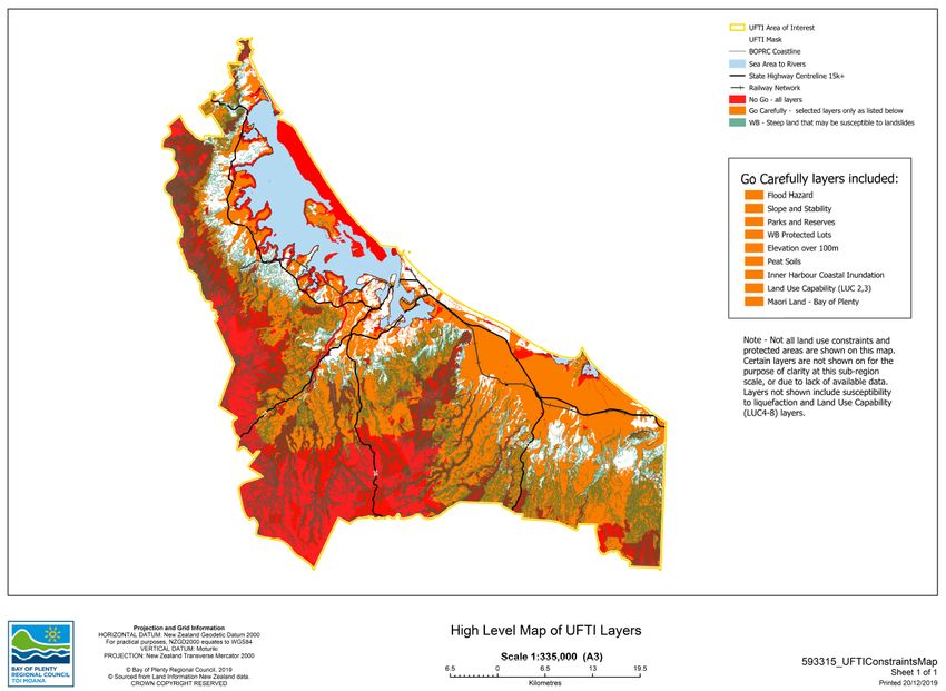
Layer         Description               Planning Horizon              Strategy               Examples

        Layer 4       Wāhi Mahi                 The       priority            Working                Future urban areas
                                                development                                          (business land)
                                                                              The places where
                                                areas
                                                                              we      work   and
                                                (30 years)                    transact (and often
                                                                              live too).

        Layer 5       Wāhi noho                                               Living                 Future urban areas
                                                                                                     (communities)
                                                                              The places where
                                                                              we live, (and oftern
                                                                              work too)

        Layer 6       Whakamana                 The        required           Infrastructure         Schools,       health
                                                growth      leading                                  faciltities,    social
                                                                              The elements that
                                                and       enabling                                   housing,       marae,
                                                                              enable       and
                                                investment     and                                   potable        water,
                                                                              support
                                                actions (30 yers)                                    wastewater.
                                                                              development

    5.0 Context and Constraints
    The context and constraints for spatial planning include the natural and physical resources of the
    subregion and the drivers of growth that create demand for and pressure on those resources.
    Constraints maps have been developed showing the natural and physical resouces that will
    influence long term spatial planning decisions.
    Population and employment projections have been prepared to provide an understanding of the
    scale of future growth that will need to be accommodated in the long term.

    5.1              Wāhi Toitū/Protection
    Wāhi Toitū enduring presence that should be protected from development in perpetuity,
    commonly referred to as “no go” areas.
    Wāhi Toitū are shown in the constraints map in Appendix 1.
    The following commentary identifies the natural and physical resources that fall within this
    category and the policy instruments that support this.

    5.1.1            Coastal Environment

    The preservation of the natural character of the coastal environment (including the coastal marine
    area) is a matter of national importance 3. Adverse effects of activities on natural character in
    areas of the coastal environment with outstanding natural character must be avoided 4. The

    3
        RMA s 6(a)
    4
        NZCPS Policy 13(1)(a)

4   High Level Spatial Plan | Urban Form Scenarios for Western Bay of Plenty Sub-region
maintenance and enhancement of public access to and along the coastal marine area, lakes, and
rivers is also a matter of national significance 5.
The natural character of the coastal environment of the Tauranga Metro Area has been assessed
and classified and shown in the Regional Coastal Environment Plan (RCEP).
There is strong community support for the protection of the coastal environment and the provision
of public access.
Areas of the coastal environment having high and outstanding natural character, and coastal
margins are generally not suitable for development.
Mapped constraints include:
• Areas of the coast assessed as having high and outstanding natural character;
• The coastal environment as defined by the operative Regional Coastal Environment Plan.
5.1.2 Wetlands, Lakes and Rivers
The preservation of the natural character of wetlands, lakes, and rivers is a matter of national
importance 6. The maintenance and enhancement of public access to and along lakes and rivers
is also a matter of national significance 7.
The proposed new national direction for freshwater proposes actions to stop the degradation of
waterways and restore them to a healthy state 8. Under the proposed policy every territorial
authority must include objectives, policies, and methods in its district plan at the next review of
the plan to avoid, remedy, or mitigate the cumulative adverse effects of land use resulting from
urban development on waterbodies and sensitive receiving environments 9.
Proposals include protecting remaining natural wetlands (e.g. prohibiting earth disturbance for
drainage in any part of a natural wetland) and putting tighter controls on certain activities that
damage inland and coastal wetlands 10.
Mapped constraints include wetlands and rivers, and their margins.
5.1.3 Outstanding Natural Features and Landcapes
The protection of outstanding natural features and landscapes from inappropriate subdivision,
use, and development is a matter of national importance 11.
Outstanding natural features and landscapes have been assessed at regional and district scale.
Mapped features include the identified outstanding natural features and landscapes.
5
RMA s6(d)
6
RMA s 6(a)
7
RMA s6(d)
8
https://www.mfe.govt.nz/publications/fresh-water/action-healthy-waterways-summary-glance-summary-of-discussion-document
9
Draft National Policy Statement for Freshwater Management 3.4 Integrated management
10
Proposed National Environmental Standards for Freshwater
11
RMA s 6 (b)
High Level Spatial Plan | Urban Form Scenarios for Western Bay of Plenty Sub-region 55.1.4 Indigenous Vegetation and Habitats of Indigenous Fauna
The protection of areas of significant indigenous vegetation and significant habitats of indigenous
fauna is a matter of national importance 12.
The proposed National Policy Statement for Indigenous Biodiversity provides direction on
priorities to maintain indigenous biodiversity under the RMA 13. Managing Significant Natural
Areas and other provisions in the proposed National Policy Statement for Indigenous Biodiversity
will ensure biodiversity is maintained overall, including no reductions in the following:
• the size of populations of indigenous species
• indigenous species occupancy across their natural range the function of ecosystems
and habitats
• the full range and extent of ecosystems and habitats
• connectivity between, and buffering around, ecosystems
• the resilience and adaptability of ecosystems.
Areas requiring protection from development include the public conservation estate and private
land that has formal protection such as through QE11 covenants.
Mapped constraints include the protected public and private conservation estate.
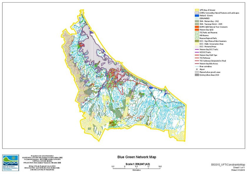
A Blue Green Network map is included in Appendix 1 showing significant natural areas.
5.1.5 Places of Significance to Manawhenua
The relationship of Māori and their culture and traditions with their ancestral lands, water, sites,
waahi tapu, and other taonga is a matter of national importance 14.
Protected areas and sites include marae, pa, wāhi tapu, urupā, maunga, awa, and Tauranga
Moana that make up the wider cultural landscape. It is recognised that all such features may not
be captured in current information.
Mapped constraints include the known protected sites and areas.
A Cultural/Tangata Whenua map is included in Appendix 1 showing the key areas and sites of
significance.
5.1.6 Historic Heritage
The protection of historic heritage from inappropriate subdivision, use, and development is a
matter of national importance 15.
Urban form decisions will influence the extent to which historic values can be maintained and
enhanced. For example, urban renewal at high densities will require replacement of older housing
stock which may possess historic values. Large scale redevelopment will also require excavation
of sites that may affect archaeological values.
12
RMA s 6 (c)
13
https://www.mfe.govt.nz/publications/biodiversity/he-kura-koiora-i-hokia-summary-of-discussion-document-proposed-nps
14
RMA s 6(e)
15
RMA s 6 (f)
6 High Level Spatial Plan | Urban Form Scenarios for Western Bay of Plenty Sub-regionProtected sites and areas include site that have formal protection under the Heritage NZ Act.
While this is an important consideration, it is not practicable to map sites and areas of heritage
significance for high level spatial planning.
This issue should be addressed through more detailed place-specific spatial planning.
5.2 Wāhi Toiora/Mitigation
Wāhi toiora are the places where change or development can occur, but only with great care and
where effects can be mitigated to an acceptable level.
In practical terms, almost all land will be subject to some contraining features, although the degree
of constraint will vary.
The following commentary identifies the key natural and physical resources that fall within this
category.
5.2.1 Natural Hazards
The management of significant risks from natural hazards is a matter of national importance 16.
Natural hazards in the subregion include flooding, land instability, coastal erosion, coastal
inundation, ground shaking and tsunami.
The development of natural hazard policies for the RPS included region wide community
engagement to determine acceptable risk outcomes for development.
If areas of known susceptibility to natural hazards are identified for future urban development, a
risk assessment will need to be undertaken to establish that a low natural hazard risk will be
achieved on development sites after completion of the development 17.
The RPS also requires development in natural hazard zones subject to high natural hazard risk
to reduce the level of risk from natural hazards to medium levels (and lower if reasonably
practicable) 18. This policy applies to several areas of existing urban development subject to high
risk.
Mapped constraints include the areas of susceptibility to natural hazards including:
• Areas where flooding is of a depth and velocity that cannot be mitigated;
• Areas where development would result in or increase significant flooding on other
land that cannot be mitigated;
• Areas with a high risk of liquefaction;
• Areas known to have instability such as steep slopes and the presence of underlying
peat layers;
• Areas affected by coastal erosion and inundation.
A Natural Hazards map is included in Appendix 1 showing the key areas of natural hazard
susceptibility.
16
RMA s6 (h)
17
RPS Policy NH 4B: Managing natural hazard risk on land subject to urban development
18
RPS Policy NH 3B: Natural hazard risk outcomes
High Level Spatial Plan | Urban Form Scenarios for Western Bay of Plenty Sub-region 75.2.2 Productive Rural Land
The efficient use and development of natural and physical resources is a matter that decision
makers must have regard to 19. This includes highly productive or versatile land.
A Proposed National Policy Statement on Highly Productive Land proposes that councils consider
the availability of highly productive land within their region or district for primary production now
and for future generations. Highly productive land means it has been designated Class 1, 2 or 3.
Other policy considerations are the suitability of the climate for primary production; the size of
properties to support primary production; water availability; and access to transport routes and
appropriate labour markets 20.
The NPS’s objective is not to provide absolute protection for highly productive land but to
recognise the full range of values and benefits associated with its use for primary production; and
to maintain its availability for primary production for future generations. It seeks to elevate the
importance of highly productive land within the RMA planning hierarchy.
The Regional Policy Statement already gives effect to these matters through its objective that the
productive potential of the region’s rural land resource is sustained, and the growth and efficient
operation of rural production activities are provided for 21.
The RPS requires productive rural land resource to be protected for rural production activities
outside existing and planned urban areas. This includes consideration of both the loss of
productivity of the rural area, including loss of versatile land, and cumulative impacts that would
reduce the potential for food or other primary production 22.
Mapped constraints include areas that are designated as Land Use Capability Class 3 or better.
5.2.3 Landscape Character and Amenity
The maintenance and enhancement of amenity values includes consideration of landscape
character and amenity 23.
Urban form decisons will influence the extent to which amenity values can be maintained and
enhanced. Greenfield development will displace rural landscape character and amenity. Urban
intensification will displace suburban landscape character and amenity.
While this is an important consideration, it is not practical to map areas of landscape significance,
other than those that rate as “outstanding” (See above).
This issue should be addressed through more detailed place-specific spatial planning.
5.2.4 Places of Significance to Manawhenua
The relationship of Māori and their culture and traditions with their ancestral lands, water, sites,
waahi tapu, and other taonga is a matter of national importance 24.
19
RMA s 7 (b)
20
Valuing Highly Productive Land: A Summary
21
RPS Objective 26
22
RPS Policy UG 18B: Managing rural development and protecting versatile land
23
RMA s7(c)
24
RMA s 6(e)
8 High Level Spatial Plan | Urban Form Scenarios for Western Bay of Plenty Sub-regionA principle of SmartGrowth is the active protection of Māori interests 25. This includes the
avoidance of land uses that may lead to pressure for alienation of multiple owned Māori land to
occur 26.
While protection is often an issue, some areas of whenua Māori, rae, awa and Tauranga Moana,
can be developed with appropriate mitigation.
Mapped constraints include areas of Whenua Māori.
5.2.5 Climate Change
Decision makers must have regard to the effects of climate change 27. In the context of high level
spatial planning climate change impacts are incorporated through the consideration of the
following natural and physical resource issues:
• Influences on natural hazards where future rainfall and sea level rise are factored into
natural hazard risk assesments;
• Influences on productive rural land values that will change over time, including shifts
in food production towards low GHG emission regimes;
• Urban form decisions where compact development and efficient transport networks
can support reduced GHG emissions;
• Long term migration patterns affected by climate change (e.g. population movement
away from climate based hazards).
5.3 Awarua/Corridors
Awarua are the connections and movement corridors that bind places together.
Awarua are enduring physical resources that strongly influence land use patterns, but are also
affected by those land uses.
The two identified corridors are strategic transport corridors and blue – green corridors.
5.3.1 Strategic Transport
Strategic transport corridors include state highways, local strategic roads, railways, ports/shipping
lanes, and airports/airspace.
Strategic road and rail transport corridors are shown on the Constraints Map in Appendix 1.
Safe and efficient movement is one of the UFTI Challenges. Western Bay of Plenty’s harbour
geography and dispersed land use pattern (places of employment, education, and recreational
locations), and increasing traffic volumes negatively impacts on the safe and efficient movement
of people and goods 28.
25
Smartgrowth 2016 Principles 11.5
26
Smartgrowth 2004 Resource Protection Principles
27
RMA s7(i)
28
UFTI Foundation Report
High Level Spatial Plan | Urban Form Scenarios for Western Bay of Plenty Sub-region 9Opportunities for transport system improvements are identifed that relate directly to high level
spatial planning include:
• Increasing housing densities where there are good transport connections and choices
available for people to access the many urban and rural social and economic
opportunities available within the sub-region;
• Designing communities to have multimodal transport connections and, where applicable,
be self-contained;
• Reducing the reliance on private vehicles particularly when travelling to jobs and schools
which will also help reduce carbon emissions;
• Maximising the use of the whole transport network to create a more resilient
transportation system, including maximising the local network;
• Using the rail network to move more freight, and when and, where applicable, people.
Exploration of significantly improved public transport systems, including rapid mass transit
options 29, is an important component of scenario based spatial planning.
5.3.2 Blue-Green Corridors
Blue – Green Corridors include coast, harbours, estuaries, major rivers and other water bodies,
along with their associated riparian ecological margins and flood plains.
The preservation of the coastal environment and lakes and rivers and their margins is also matter
of national importance as noted above.
A Blue Green Network map is included in Appendix 1.
5.4 Wāhi Mahi/Work Places
Wāhi Mahi are the places where people work and transact. This includes industrial and
commercial land, and also residential areas where significant numbers (around 25%) are
employed in education, health and home based business.
5.4.1 Employment Projections
Total employment in the subregion is expected to grow by 39,375 for the period 2017-2063 and
most of this growth is expected to occur by 2048/2050 30.
5.4.2 Industrial Land Demand
Future industrial land needs can be projected by considering past long term industrial land uptake.
The long term uptake of land in the subregion has been approximately 15ha of developable land
per year, although this has varied signficantly from year to year.
29
Rapid transit systems provide efficient travel along a dedicated corridor typically by bus or rail.
30
Smart Growth Employment Projections Methodology and Key Findings 2017
10 High Level Spatial Plan | Urban Form Scenarios for Western Bay of Plenty Sub-regionThe level of confidence in this rate of land uptake remaining relevant into the future is affected by
several trends:
• Increasing land needs for stormwater treatment and flood management areas, ecological
and landscape buffers, cultural site protection, and expanded road space for improved
safety, and to accomodate larger vehicles and infrastructure corridors;
• Reducing land needs resulting from more efficient use of space by capital intensive
industries and new technology, more intensive redevelopment of existing areas, greater
regulation of retail and office leakage from commercial centres and residential areas, and
the movement of some activities such as manufacturing to other (sometimes off-shore)
locations.
For the purpose of high level spatial planning, these countervailing trends are assumed to be
neutral overall and, for reasons of prudency, the historic land demand should be projected
forward.
5.4.3 Industrial Land Supply
Approximately 440ha of vacant industrial land is either zoned or in the stage of being planned.
Location Area
Tauriko (remaining) 40ha
Tauriko Extension 75-150ha
Rangiuru 150ha
Te Puna 30ha
Omokoroa 30ha
Wairakei (Papamoa East Employment Zone) 60ha
Te Tumu (Planned) 60ha
At historic rates of uptake this area should provide overall capacity for 30- 40 years. However, for
some corridors like Tauriko what is zoned and planned will not be sufficient for even 20 years.
A further area of at least 600ha is likely to be required for long term development beyond this
period.
It is desirable from a transport point of view to have industrial land supply east and west of the
harbour due to limited east-west freight routes available through the sub-region due to harbour
crossings. This enables employment hubs to be more evenly dispersed.
The yeild of developable land from raw rural land is also an important consideration which will
vary according to the topography and the sensitivity of other land features in future urban areas.
For example, at Tauriko a total area of approximately 300ha of rural land yeilded approximately
180ha of developable land (50-60% yeild).
High Level Spatial Plan | Urban Form Scenarios for Western Bay of Plenty Sub-region 115.4.4 Commercial Land
Future commercial land needs have not been specifically assessed as they represent a relatively
small area of land relative to residential and industrial land.
The bulk of retail employment growth in Tauranga City is projected to occur in the city centre and
the large shopping malls at Tauranga Crossing and Bayfair, located to the west and east
respectively. A further town centre at Wairakei (The Sands) is currently in the design stage and
will service the eastern growth corridor retail catchment. These are all areas of such a scale that
they serve the sub-regional retail catchment and beyond.
New centre land needs can be assessed by consideration of catchments of demand at the time
that structure plans for new urban areas are developed.
5.5 Wāhi Noho/Living Places
Wāhi noho are the places where we live. This includes urban/suburban residential areas,
retirement communities and papakāinga, as well as people living in commercial centres.
5.5.1 Population and Household Projections
The total population of the sub-region was approximately 190,000 people in 2018.
In the next 30 years the subregional population is expected to reach 270,000 people. This is
projected to equate to around 43,000 additional houses. Fewer additional houses will be required
if household occupancy remains at current levels rather than declines as projected.
Projections over the next 50-100 years are difficult to make as there are many uncertainties. For
high level spatial planning purposes it is prudent to use a high growth scenarios for the period out
to 100 years. It is a plausible outcome that may occur and therefore should be planned for.This
allows the testing of different scenarios and will help ensure the protection of corridors and nodes
for the selected spatial option should population growth be greater that what is currently projected.
The timeframe of 100 years is not the critical component, but the population figures are. For this
reason, and as with the SmartGrowth projections, the trigger for various interventions (eg release
of new development capacity or delivery of infrastructure projects) is the population numbers, not
the year.
Taking the above into account the 50-100 year growth scenario for the western Bay of Plenty sub-
region population is assumed at 400,000 people or 200,000 additional people and 100,000
additional houses.
Growth in the Māori population is a specific consideration and is likely to lead to increasing
demand for papakianga housing. Recent strategic planning for papakāinga has projected
development at the rate of 35 additonal houses per year 31.
5.5.2 Residential Land Demand
Residential land needs are highly sensitive to variables such as the extent of redevelopment of
existing urban areas at higher densities and the density of development in greenfield areas.
31
Joint Agency Group Strategic Plan 2015-2020
12 High Level Spatial Plan | Urban Form Scenarios for Western Bay of Plenty Sub-regionThe urban form scenarios that are developed and evaluated below highlight the efffect of these
variables.
The yield of developable land from raw rural land is also an important consideration which will
vary according to the topograhy and the sensitivity of other land features in future urban areas.
For example, at Te Tumu a total area of approximately 700ha of rural land has yeilded
approximately 350ha of developable land (50% yeild).
5.5.3 Residential Land Supply – Greenfield
Preliminary assessments of greenfield capacity in the subregion indicate a likely upper limit of
112,000 additional houses allocated as follows:
Location Houses
Already zoned 9500
Proposed zones @ Te Tumu, Omokoroa, Tauriko West and Keenan 15,000
Road) @ 20 houses per hectare
Potential greenfield capacity @ 20 houses per hectare
Northern Corridor 27,000
Western and Southern Corridor 30,000
Eastern Corridor 30,000
Further work will be required to confirm these capacity estimates.
5.5.4 Residential Land Supply – Intensification
Preliminary assessments of capacity for intensification within the exising urban areas of the
subregion indicate a likely upper limit of 43,000 additional houses allocated as follows:
Location Houses
Te Papa @ 50 dwellings/ha 19000
Tauranga West (Otumoetai North/ Matua – Judea/ Te Reti) @ 30 13000
dwellings/ha
Mount Maunganui-Papamoa @ 30 dwellings/ha 6000
Ōmokoroa 32 3000
Te Puke 2000
32
Low confidence in this figure - probability of intensification also limited by how new housing stock, covenants, high improvement
values etc
High Level Spatial Plan | Urban Form Scenarios for Western Bay of Plenty Sub-region 135.5.5 Residential Land Supply – Papakāinga
Exising marae sites do not have capacity or infrastucture for long term growth of significant scale.
A 2008 review of 13 marae identified typical capacities of 20-50 dwellings, well less than the
capacity needed for projected long term demand of 35 dwellings per year.
To accommodate papakāinga of significant scale, additional development areas will need to be
identified, coupled with public investment in infrastructure as occurs with other urban growth area
planning.
This is an issue that will require further detailed consideration through engagement with tangata
whenua. However, it is important to recognise the potential contribution that papakāinga can make
to meeting future housing needs.
5.6 Whakamana/Infrastructure
Whakamana is the infrastructure or elements that enable and support urban development.
Whakamana seldom lead or strongly influence urban form. Neverthless, they are critical
considerations and may be significantly affected by urban form.
Whakamana include:
• Marae
• Education – schools, universities and
• Health – primary and secondary
• Open Space – local and city wide reserves
• Recreation facilities – pools, stadiums, theatres
• Water
• Wastewater
• Stormwater
• Energy
• Telecommunications
6.0 Urban Form Scenarios
6.1 Method
The method for developing scenarios has generally followed the framework from the European
Foresight Platform (EFP) 33.
“…the scenario method is a policy analysis tool that helps describe a possible set of future
conditions. At national, regional and local level scenarios can be used to improve planning
33
http://www.foresight-platform.eu/community/forlearn/how-to-do-foresight/methods/scenario/
14 High Level Spatial Plan | Urban Form Scenarios for Western Bay of Plenty Sub-regioncapacity, to enrich strategic public policy decisions and to guide major capital
investments. For example, the development of scenarios allows new insights into the
opportunities and risks involved in making decisions about public transport that would
have major consequences for the development of a region over the next few decades.”
To be effective, scenarios must be plausible, consistent and offer insights into the future:
• Plausibility: A scenario must fall within the limits of what might conceivably happen;
• Consistency: A scenario must be internally consistent. This means that the
combination of logics in a scenario must not have any built-in inconsistency that could
undermine the credibility of the scenario;
• Decision-making utility: each scenario should contribute specific insights into the
future that will lead to the decision focus that was selected.
The focal issue for scenario development for UFTI is the development of a sustainable urban
spatial plan for the subregion. This is for a long term plan, looking out to a planning horizon of
100 years, but focussing on specific urban form issues over the next 30 years.
The factors that need to be considered in developing scenarios are outlined in the context and
constraints section of this report. They include the natural and physical resources that constrain
or shape growth and the drivers that have a direct influence including population growth and
change and economic shifts that result in changes in demand on resources.
Common assumptions on the scale and nature of population and employment change are made
across all the scenarios. There is a relatively high level of confidence in population forecasts over
the next 30 years and these are used in a range of policy documents including the proposed
subregional Future Development Strategy.
As noted above, for the very long term (50-100 years) a high growth scenario has been adopted
to ensure the protection of corridors and nodes for the selected spatial option should the
population grow more than is currently projected.
The scenarios focus on the factors that are the potential shapers of a sustainable urban form and
transport outcome. The main differentiators for each scenarios are therefore:
• The proportional allocation of future urban development between existing urban
areas (“intensification” or growing up) and extensions of the urban area (“greenfield”
or growing out);
• The density of future urban development both in intensification and greenfield areas;
• The allocation of growth between the subregion’s urban growth corridors (north,
south/west, and east);
• The nature of the associated transport network, and the extent to which this is
supported by public transport ranging from low levels of service through to rapid mass
transit systems.
There is a relatively high level of certainty in:
• the eventual delivery of additional urban land in the planned greenfield areas and the
ability to increase densities in these new areas;
• the demand for housing favouring more compact forms due to changes in household
structure and the need to achieve affordability;
High Level Spatial Plan | Urban Form Scenarios for Western Bay of Plenty Sub-region 15• improving the transport system, focussing on enhanced mode shifts to active modes
and public transport, including rapid transit on main routes.
There is uncertainty in:
• the ability to significantly increase densities at scale in intensification areas due to
risks associated with development feasibility and potential local community
opposition;
• the delivery of a rapid mass transit system using rail as the scale and density of urban
development may be unable to support this without significant subsidisation.
Six scenarios have been developed, in addition to the “base case”, which are the minimum
number of scenarios needed to contain the areas of uncertainty identified above.
In developing the scenarios the following qualities have been sought:
• Plausibility: The selected scenarios is plausible and falls within the limits of what might
conceivably happen;
• Differentiation: the scenarios are structurally different and are not simply variations of a
base case;
• Consistency: The combination of logics in a scenario are consistent;
• Decision making utility: Each scenario contributes specific insights into the future that will
allow on the decision focus that was selected;
• Challenge: the scenarios challenge conventional wisdom about the future.
Consideration has also been given to known limitations and the changes to existing conditions
that may be needed in order to make a scenario plausible.
Scenarios have been developed through collaboration across a multi – agency team informed by
research and the results of community engagement on future urban form options.
Scenarios have been critiqued by senior management and an independent UFTI expert panel.
The critiquing process resulted in a significant shift toward more differentiated density and
transport outcomes being achieved within the scenarios.
6.2 Base Case – Continuation of Status Quo
The base case is defined for comparison with alternative scenarios. The base case is a
continuation of current development trends.
85% of development is accommodated in greenfield urban growth areas plus further staged
greenfield growth in corridors following investigation of all market-feasible areas. This will require
multiple greenfield growth fronts across the three corridors due to the scale of land area required.
A further 1200 ha of raw rural land for 11,000 dwellings would be needed over the next 30 years
to accommodate the base case beyond the currently planned urban growth areas assuming
densities of 15-20 dwellings/ha. This additional land area would be distributed across all urban
growth corridors.
15% of development is accommodated though intensification of existing urban areas, with
locations determined by the market. This is likely to be directed toward higher amenity areas
including coastal locations and mixed use centres.
16 High Level Spatial Plan | Urban Form Scenarios for Western Bay of Plenty Sub-regionThe density of development is assumed to increase incrementally over time as a result of
changing household needs and affordability influencing the market.
Transport is provided by a road based system, with a continuation of reliance on private transport
modes supporting low density peripheral expansion. Public transport centres on existing and new
nodes mainly for low frequency home/work trips and basic level of service with limited bus priority
measures.
In the long term (50-100 years), 6400ha of raw rural land would be needed to accommodate the
base case beyond the currently planned urban growth areas.
The issues for this scenario arise from the large and expanding urban footprint, with poor
outcomes for the protection of productive rural land and landscape character and amenity, high
dependency on private vehicles and associated energy consumption and carbon emissions. The
base case also rates poorly due to overall inefficiency in the delivery of supporting infrastructure
over a wide and dispersed area.
Current policy direction supports a strong shift towards more sustainable urban form and transport
outcomes.
6.3 Alternative Scenarios Suggested for Evaluation
6.3.1 Overview
Conceptual illustrations of suggested alternative scenarios are included in Appendix 2.
A table setting out the spatial allocation of houses for each scenario over the next 30 years and
100 years is included in Appendix 3.
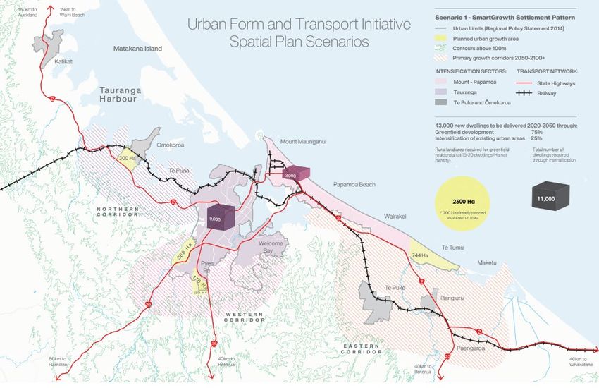
6.3.2 Scenario 1 – SmartGrowth Settlement Pattern
Scenario 1 is for fully effective implementation of the SmartGrowth Settlement Pattern generally
as prescribed in the Bay of Plenty Regional Policy Statement and other related policies such as
the Public Transport Strategy, and also reflected in the proposed Future Development Strategy.
High quality (frequent, reliable, convenient, and efficient) public transport services support
significant mode shift from single occupancy vehicles on key transport corridors . Region-wide
integrated ticketing, and new technology provides real-time information to users . Bus priority
measures are implemented in urban areas. Rapid transit is supported in some development
locations.
Most new jobs and housing are in greenfield areas, with modest increases in densities over time.
No more than 75% of development is accommodated in greenfield urban growth areas plus further
staged greenfield growth in corridors.
A further 800 ha of raw rural land for 7,000 dwellings would be needed over the next 30 years to
accommodate this scenario beyond the currently planned urban growth areas assuming densities
of 15-20 dwellings/ha. This additional land area would be distributed across all urban growth
corridors.
At least 25% of development is accommodated though intensification of existing urban areas,
with a strong focus on the Te Papa corridor, and a modest increase along the coast.
High Level Spatial Plan | Urban Form Scenarios for Western Bay of Plenty Sub-region 17The density of this development is assumed to increase significantly \with a strong focus on the
enhancement of neighbourhood amenity and easily accessible services with centres.
In the long term (50-100 years), 4,000-5,000 ha of raw rural land (actual area dependent on
density) may be needed to accommodate this scenario beyond the currently planned urban
growth areas.
6.3.3 Scenario 2 - Connected Nodes with Rapid Transit
Scenario 2 is a dispersed urban form but with intensification of all Tauranga centres plus
intensification at Omokoroa and Te Puke. Rapid transit is provided along key routes and there
are frequent PT services across the network. There is substantial investment in active modes and
micro-mobility.
50% of growth is accommodated in greenfield urban growth areas. Development in greenfield
areas would be encouraged at significantly higher densities oriented towards transit hubs.
50% of development is accommodated though intensification of existing urban areas, focussing
significantly higher densities towards mixed use centres at transit hubs. Intensification is mainly
accommodated in Te Papa but also with substantial intensification in Ōmokoroa.
No further rural land would be needed over the next 30 years to accommodate this scenario
beyond the currently planned urban growth areas. Capacity for 4,000 further houses would remain
in the planned greenfield areas. Hence this option does not fully align with the agreed settlement
pattern the SmartGrowth Partners are working to for the next 30 years.
In the long term (50-100 years) this scenario exceeds the estimated capacity for intensification by
7,000 houses resulting in the need to accommodate the excess elsewhere in greenfield areas.
This additional land would primarily be provided in the eastern corridor, likely to be in the form of
a new satellite settlement.
1,700 ha of raw rural land would be needed to accommodate this scenario beyond the currently
planned urban growth areas, assuming densities of 30-40 houses/ha which is higher than the
current capacity assessment.
6.3.4 Scenario 3 - Three Major Centres with Rapid Transit
Scenario 3 is a centres-based intensification scenario emphasising Te Papa, the coastal strip,
and Tauriko-Pyes Pa. Rapid transit is provided along key routes and there are frequent public
transport services across the network. There is substantial investment in active modes and micro-
mobility.
30% of growth is accommodated in greenfield urban growth areas. Development in greenfield
areas is encouraged at significantly higher densities oriented towards transit hubs. Mixed
greenfield and intensification occurs in in Tauriko-Pyes Pa, and medium density greenfield occurs
throughout Te Tumu. No further rural land would be needed over the next 50 years to
accommodate this scenario beyond the currently planned urban growth areas.
70% of development is accommodated though intensification of existing urban areas, focussing
significantly higher densities towards mixed use centres at transit hubs. Extensive intensification
is mainly accommodated in Te Papa.
No further rural land would be needed over the next 30 years to accommodate this scenario
beyond the currently planned urban growth areas. Capacity for 13,000 further houses would
18 High Level Spatial Plan | Urban Form Scenarios for Western Bay of Plenty Sub-regionremain in the planned greenfield areas. Hence this scenario within the 30 year timeframe is not
consistent with the agreed settlement pattern that SmartGrowth is working to.
In the long term (50-100 years) this scenario exceeds the estimated capacity for intensification
(by 27,000) houses resulting in the need to accommodate the excess elsewhere in greenfield
areas. This additional land would primarily be provided in the eastern corridor, likely to be in the
form of a new satellite settlement.
1,700 ha of raw rural land would be needed to accommodate this scenario beyond the currently
planned urban growth areas, assuming densities of 30-40 dwellings/ha which is higher than the
current capacity assessment.
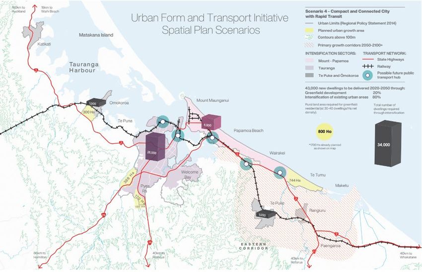
6.3.5 Scenario 4 - Compact and Connected City with Rapid Transit
Scenario 4 is an ambitious medium-high density scenario. Rapid transit is provided along key
routes and there are frequent PT services across the network. There is substantial investment in
active modes and micro-mobility.
20% of growth is accommodated in greenfield urban growth areas. Development in greenfield
areas is encouraged at significantly higher densities oriented towards transit hubs. No further rural
land would be needed over the next 50 years to accommodate this scenario beyond the currently
planned urban growth areas.
80% of development is accommodated though intensification of existing urban areas, focussing
significantly higher densities across the CBD and all centres at 30-60+ households per Ha and
medium density at a minimum of 30 households per Ha across the balance of the existing urban
area.
No further rural land would be needed over the next 30 years to accommodate this scenario
beyond the currently planned urban growth areas. Capacity for 17,000 further houses remains in
the planned greenfield areas. Hence this scenario within the 30 year timeframe is not consistent
with the agreed settlement pattern that SmartGrowth is working to.
In the long term (50-100 years) this scenario exceeds the estimated capacity for intensification by
37,000 houses, resulting in the need to accommodate the excess elsewhere in greenfield areas.
This additional land would primarily be provided in the eastern corridor, likely to be in the form of
a new satellite settlement.
1,700 ha of raw rural land would be needed to accommodate this scenario beyond the currently
planned urban growth areas, assuming densities of 30-40 dwellings/ha which is higher than the
current capacity assessment.
6.3.6 Scenario 5 - Connected Nodes accessed by Rail corridor
Scenario 5 is rail transit oriented medium-high density scenario.
60% of growth is accommodated in greenfield urban growth areas. Development in greenfield
areas is encouraged at significantly higher densities oriented towards transit hubs.
40% of development is accommodated though intensification of existing urban areas, focussing
significantly higher densities towards mixed use centres at rail transit hubs through Tauranga,
plus intensification nodes in proximity to rail transit hubs in Ōmokoroa, Te Puna and Te Puke.
No further rural land would be needed over the next 30 years to accommodate this scenario
beyond the currently planned urban growth areas. However, the currently planned growth areas
High Level Spatial Plan | Urban Form Scenarios for Western Bay of Plenty Sub-region 19would be close to capacity so there is a reasonable likelihood that some additional greenfield land
would be needed, particularly with delays in transition.
1,800 ha of raw rural land would be needed to accommodate this scenario beyond the currently
planned urban growth areas, assuming densities of 30-40 dwellings/ha which is higher than the
current capacity assessment. This additional land area would be in the northern and eastern
corridors at rail transit hubs.
6.3.7 Scenario 6 - Eastern Satellite centre accessed by Rail corridor
Scenario 6 is also rail transit oriented medium-high density scenario but prioritises growth
allocation to a new eastern satellite centre.
60% of growth is accommodated in greenfield urban growth areas. Development in greenfield
areas is encouraged at significantly higher densities oriented towards transit hubs.
40% of development is accommodated though intensification of existing urban areas, focussing
significantly higher densities towards mixed use centres at rail transit hubs through Tauranga.
1,800 ha of raw rural land would be needed to accommodate this scenario beyond the currently
planned urban growth areas, assuming densities of 30-40 dwellings/ha which is higher than the
current capacity assessment. This additional land area would primarily be in the eastern corridor
in to a single new centre with a major a rail transit hub.
6.4 Excluded Scenarios
Several scenarios were considered but excluded through the scenario development process as
not being suitable. These scenarios and their reasons for exclusion are set out below.
6.4.1 Restricted or Capped Growth
This scenario would put in place measures to discourage growth, including restricting the ability
to grow up or to grow out. This would include cutting the supply of additional zoned land for urban
development.
This scenario is contrary to the Proposed National Policy Statement on Urban Development that
requires Councils to provide capacity to accommodate growth within a high growth area.
Population growth is influenced by net inward migration and increasing numbers of international
visitors. There is little that can be done at a sub-regional level to influence these. Preventing new
housing developments will not reduce the flow of people moving here but will increase house
prices and rents for those who already live here. This would have flow-on effects resulting in
higher rates of homelessness, poverty, inequality, and poorer health outcomes.
This scenario is contrary to the Proposed National Policy Statement on Urban Development that
requires Councils to provide capacity to accommodate growth within a high growth area.
6.4.2 Re-directed Growth
This scenario is similar to restricting or capping growth but would include a deliberate planning
strategy that directs growth to other locations outside the sub-region.
20 High Level Spatial Plan | Urban Form Scenarios for Western Bay of Plenty Sub-regionYou can also read