DEVELOPMENT MASTER PLAN 2016 COOKTOWN AIRPORT
←
→
Page content transcription
If your browser does not render page correctly, please read the page content below
JULY 2016

DEVELOPMENT MASTER PLAN 2016
COOKTOWN AIRPORT
Prepared for Cook Shire Council
DOCUMENT CONTROL
Document Title:      Cooktown Airport Development Master Plan 2016

Reference:           YCKN01-01

Release Date:        25 July 2016

Prepared by:         K Tonkin

Reviewed by:         L Hodgson

Released by:         K Tonkin

Revision History:    Release

 Version       Description                                 Transmitted      Reviewed by       Date

 0.3           First Draft                                 06 April 2016    CSC               29 April 2016

 0.4           Final Draft                                 16 May 2016

 0.5           Revised Final Draft (OLS plans, revenues)   03 June 2016     CSC               20 June 2016

 1.0           Final for Release                           25 July 2016

COPYRIGHT AND DISCLAIMER NOTICE
This document and the information contained herein should be treated as commercial-in-confidence. No part
of this work may be reproduced or copied in any form or by any means (graphic, electronic or mechanical,
including photocopying, recording, taping or information retrieval system) or otherwise disclosed to any other
party whatsoever, without the prior written consent of Aviation Projects Pty Ltd.

This report has been prepared for the benefit solely of the Client, and is not to be relied upon by any other
person or entity without the prior written consent of Aviation Projects Pty Ltd.

© Aviation Projects Pty Ltd, 2016. All rights reserved

YCKN01-01 COOKTOWN AIRPORT DEVELOPMENT MASTER PLAN 2016

                                                                                                                 i
TABLE OF CONTENTS
Document Control ____________________________________________________________________________ i
Copyright and Disclaimer Notice ________________________________________________________________ i
Table of Contents ____________________________________________________________________________ ii
List of Figures _______________________________________________________________________________ v
List of Tables ________________________________________________________________________________ v
EXECUTIVE SUMMARY ______________________________________________________________________ VI
Strategic objectives_________________________________________________________________________ vi
Planning horizons __________________________________________________________________________ vi
Aviation demand forecasts ___________________________________________________________________ vi
Aerodrome safeguarding ____________________________________________________________________ vii
Master Plan _______________________________________________________________________________ vii
1. PLANNING CONTEXT _____________________________________________________________________ 1
1.1. Background __________________________________________________________________________ 1
1.2. Site description _______________________________________________________________________ 3
1.3. Regional characteristics _______________________________________________________________ 3
1.4. Role and history _____________________________________________________________________ 10
1.5. Current operations __________________________________________________________________ 11
1.6. Strategic intent _____________________________________________________________________ 11
1.7. Purpose of master planning study ______________________________________________________ 11
1.8. Master planning outcomes ___________________________________________________________ 11
1.9. Planning horizons ___________________________________________________________________ 12
1.10. Previous planning studies ____________________________________________________________ 12
1.11. Scope and Limitations _______________________________________________________________ 12
1.12. Methodology _______________________________________________________________________ 13
1.13. Stakeholder Consultation _____________________________________________________________ 13
2. EXISTING AERODROME FACILITIES ______________________________________________________ 14
2.1. Aeronautical infrastructure ___________________________________________________________ 14
2.2. Support facilities ____________________________________________________________________ 14
2.3. Landside development _______________________________________________________________ 15
2.4. Ground transport ____________________________________________________________________ 15
3. DEMAND _____________________________________________________________________________ 16
3.1. Regional population growth ___________________________________________________________ 16
3.2. Historical passenger demand _________________________________________________________ 16
3.3. Historical aircraft movement demand __________________________________________________ 17
3.4. Forecast passenger demand __________________________________________________________ 18
3.5. Aircraft parking capacity _____________________________________________________________ 18
3.6. Passenger terminal capacity __________________________________________________________ 19
4. DEVELOPMENT CONSTRAINTS___________________________________________________________ 20
4.1. Planning ___________________________________________________________________________ 20
4.2. Regulatory context __________________________________________________________________ 23
4.3. Design Standards ___________________________________________________________________ 24

YCKN01-01 COOKTOWN AIRPORT DEVELOPMENT MASTER PLAN 2016

                                                                                                     ii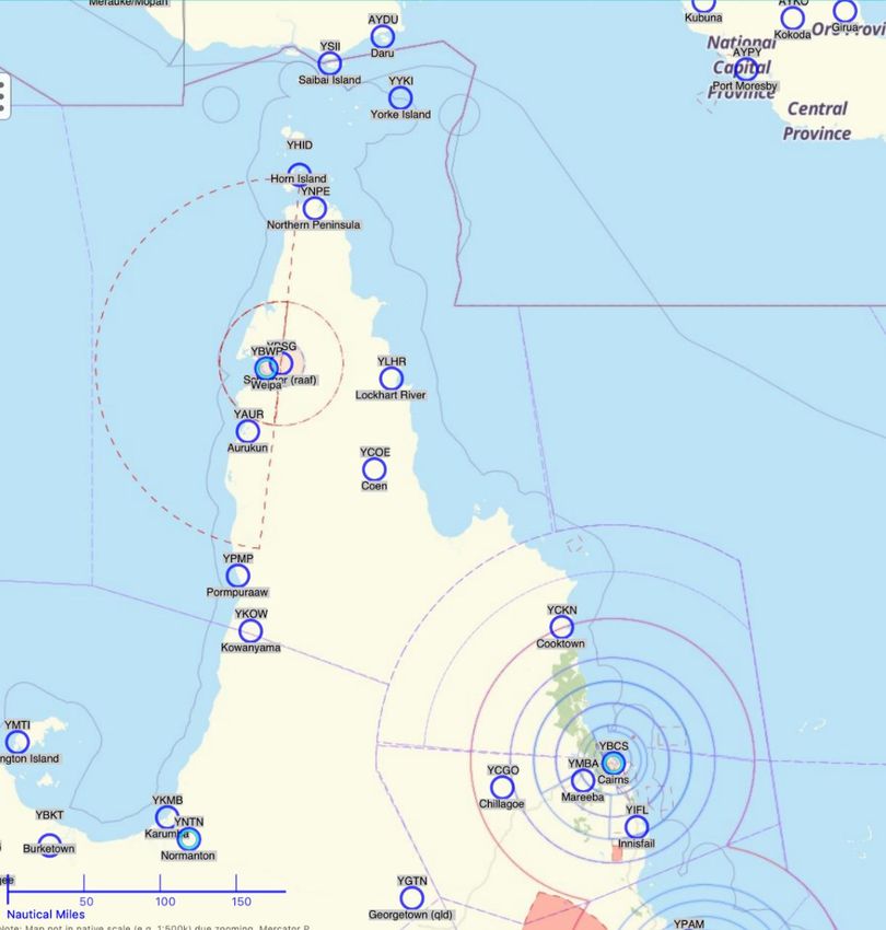
4.4. Environmental ______________________________________________________________________        25
4.5. Heritage ___________________________________________________________________________        25
4.6. Other development control measures ___________________________________________________      25
5. AIRCRAFT MOVEMENT AREAS __________________________________________________________            26
5.1. Runway ____________________________________________________________________________         26
5.2. Runway pavements __________________________________________________________________         26
5.3. Runway usability ____________________________________________________________________       26
5.4. Taxiways ___________________________________________________________________________        26
5.5. Parking aprons______________________________________________________________________        26
5.6. Hangar facilities ____________________________________________________________________      26
5.7. Helicopter facilities __________________________________________________________________    26
5.8. Aerodrome lighting __________________________________________________________________       27
6. AVIATION SUPPORT FACILITIES__________________________________________________________         28
6.1. Fuel _______________________________________________________________________________        28
6.2. Ground support equipment ____________________________________________________________       28
6.3. Navigation and approach aids _________________________________________________________      28
6.4. Weather information service __________________________________________________________      28
6.5. Aerodrome rescue and fire fighting services _____________________________________________   28
6.6. Air traffic control and airspace ________________________________________________________   28
6.7. Transport security ___________________________________________________________________      28
7. PASSENGER FACILITIES ________________________________________________________________         29
7.1. Aeromedical facilities ________________________________________________________________     29
7.2. Passenger terminal __________________________________________________________________       29
8. COMMERCIAL LAND USE AND DEVELOPMENT _____________________________________________             30
8.1. Current leasing and charging regime ___________________________________________________     30
8.2. Current airport management structure__________________________________________________      30
8.3. Future commercial and business prospects _____________________________________________      30
8.4. Managing and implementing development plan __________________________________________       31
9. GROUND TRANSPORT SYSTEMS _________________________________________________________            32
9.1. External network ____________________________________________________________________       32
9.2. Internal network ____________________________________________________________________       32
9.3. Airside access ______________________________________________________________________       32
9.4. Public car parking ___________________________________________________________________      32
9.5. Rental car parking demand ___________________________________________________________       32
9.6. Buses _____________________________________________________________________________         32
9.7. Taxis ______________________________________________________________________________        32
9.8. Aviation fuel deliveries _______________________________________________________________    32
10. UTILITIES AND CIVIL INFRASTRUCTURE___________________________________________________        33
10.1. Water _____________________________________________________________________________        33
10.2. Electricity __________________________________________________________________________     33
10.3. Sewer/septic _______________________________________________________________________       33
10.4. Communications ____________________________________________________________________        33
10.5. Drainage ___________________________________________________________________________       33

YCKN01-01 COOKTOWN AIRPORT DEVELOPMENT MASTER PLAN 2016

                                                                                                      iii
10.6. Perimeter fencing ___________________________________________________________________ 33
11. AERODROME SAFEGUARDING __________________________________________________________ 34
11.1. Operational airspace _________________________________________________________________ 34
11.2. Lighting area buffer zone _____________________________________________________________ 34
11.3. Wildlife hazard buffer zone ____________________________________________________________ 34
11.4. Building restricted areas for aviation facilities ___________________________________________ 35
11.5. Public safety areas __________________________________________________________________ 35
11.6. Aircraft noise _______________________________________________________________________ 35
12. MASTER PLAN RECOMMENDATIONS _____________________________________________________ 36
12.1. Immediate recommended works _______________________________________________________ 36
12.2. Short term _________________________________________________________________________ 36
12.3. Long term __________________________________________________________________________ 37
13. REVENUE/COST ANALYSIS _____________________________________________________________ 38
13.1. Revenues __________________________________________________________________________ 38
13.2. Costs ______________________________________________________________________________ 38
ACRONYMS AND ABBREVIATIONS ____________________________________________________________ 39
REFERENCES _____________________________________________________________________________ 41
ANNEXURES ______________________________________________________________________________ 42
ANNEXURE 1 – DEVELOPMENT MASTER PLAN DRAWINGS _________________________________________ 1
ANNEXURE 2 – OBSTACLE LIMITATION SURFACE DRAWINGS ______________________________________ 1

YCKN01-01 COOKTOWN AIRPORT DEVELOPMENT MASTER PLAN 2016

                                                                                                         iv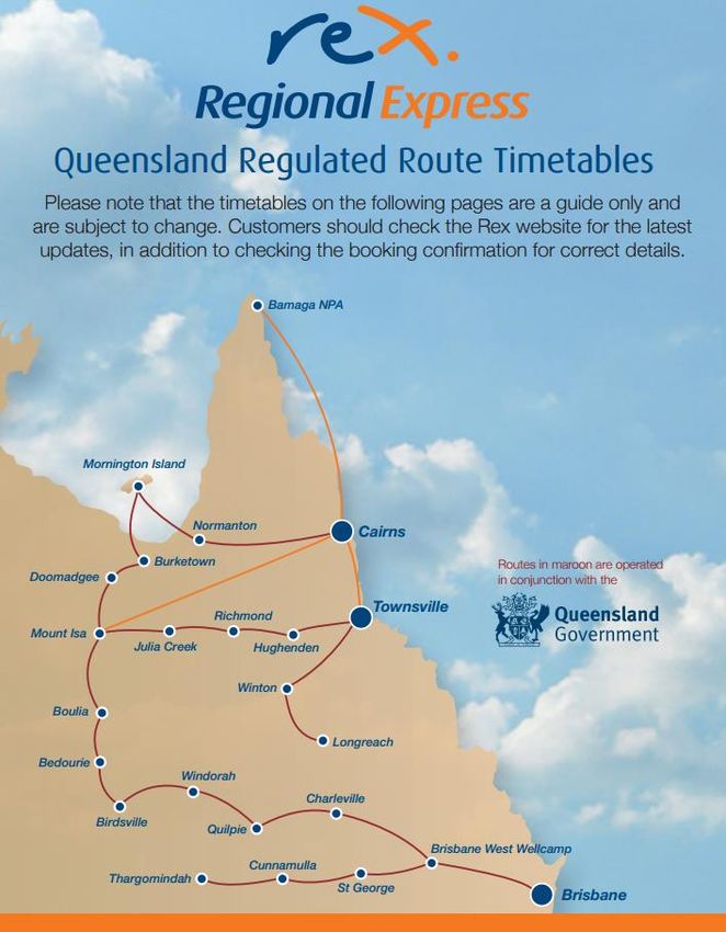
LIST OF FIGURES
Figure 1 Cook Shire Council boundaries..................................................................................................................... 1

Figure 2 Location Plan ................................................................................................................................................. 2

Figure 3 Site Plan ......................................................................................................................................................... 3

Figure 4 International destinations from TNQ ............................................................................................................ 5

Figure 5 Skytrans route map ....................................................................................................................................... 7

Figure 6 Regional Express Queensland regulated routes .......................................................................................... 8

Figure 7 Hinterland Aviation destinations .................................................................................................................. 9

Figure 8 Regional aeronautical situation map ........................................................................................................ 10

Figure 9 Annual passenger movements .................................................................................................................. 17

Figure 10 Annual aircraft movements ..................................................................................................................... 17

Figure 11 Passenger demand analysis .................................................................................................................... 18

Figure 12 Cook Shire Council Planning Scheme Zone Map ................................................................................... 20

Figure 13 Marton Locality ......................................................................................................................................... 21

Figure 14 Lease C in Lot 2 RP 287154 ................................................................................................................... 22

LIST OF TABLES
Table 1 TNQ DTP aviation opportunity, threats and trends ....................................................................................... 6

Table 2 Runway declared distances ........................................................................................................................ 14

Table 3 Projected populations by LGA, Cook Shire, 2011 to 2031 ....................................................................... 16

Table 4 MOS 139 Table 2.2-1 Aerodrome Reference Code ................................................................................... 23

Table 5 Physical Characteristics and OLS Design Criteria ...................................................................................... 24

Table 6 Aeronautical revenue .................................................................................................................................. 38

YCKN01-01 COOKTOWN AIRPORT DEVELOPMENT MASTER PLAN 2016

                                                                                                                                                                                 v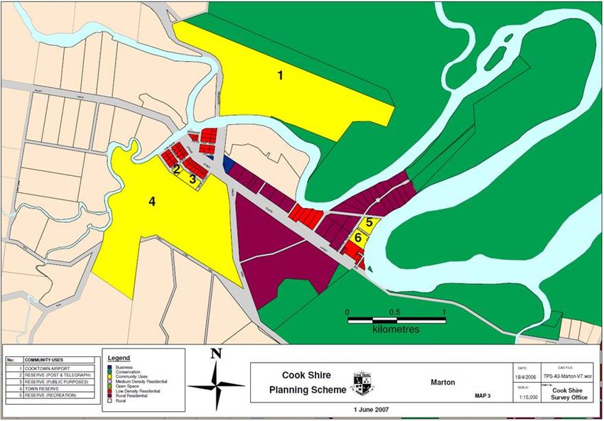
EXECUTIVE SUMMARY
Cook Shire Council (CSC) has committed to developing the aviation industry in Cooktown with the long term
goal of developing Cooktown Airport and the associated Aviation Park into a regionally significant aviation
precinct servicing Cape York and the Asia Pacific region.
The preparation of a Development Master Plan (Master Plan) for Cooktown Airport is required to meet the
needs of CSC in providing a guiding document that will achieve Council’s long term goal in that it will provide a
direction for the aerodrome in terms of future infrastructure development and cost recovery, these being
balanced against the economic and social requirements and aspirations of the local community.
Strategic objectives
The purpose of the Master Plan is to establish a framework for the future planning and development of
Cooktown Airport to ensure CSC achieves its strategic objectives and capitalises on the aeronautical and
commercial opportunities provided by the airport.
The Master Plan is intended to establish the basis for more detailed studies of design, infrastructure planning,
land use planning and environmental impacts required to achieve the strategic direction.
A key aspect of the Master Plan will be the upgrading of the aerodrome as a code 3C airport and to protect this
rating during the airport’s and associated industrial estate expansion.
Specifically, the Master Plan addresses, to the extent possible, the following elements:
Current airport characteristics;
Airport standards and planning;
Air traffic forecasts;
Airport development plan; and
Commercial and business opportunities.
Planning horizons
The Master Plan nominally considers a planning horizon of 20 years, comprised of immediate, short term and
longer term timeframes:
Immediate – 12 months;
Short term – one-five years; and
Longer term Master Plan horizon – 20 years.
Aviation demand forecasts
Annual passenger movements at the 20 year planning horizon are likely range between 15 000 and 25 000.
YCKN01-01 COOKTOWN AIRPORT DEVELOPMENT MASTER PLAN 2016
vi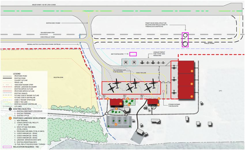
The main aircraft parking apron is not large enough to accommodate more than one large aircraft
simultaneously, and given the potential for concurrent operations by passenger transport and/or
charter/private/aeromedical or other aircraft, the higher strength main parking apron should be expanded to
meet future needs.
Ultimately, a new terminal facility should be able to accommodate the arriving and departing passengers of up
to two 68-74-seat aircraft such as the ATR72-600 or Dash 8-400, or a single 100-seat aircraft such as the
F100 or Bae146. At 80% load factor, this equates to a range of approximately 120-160 passengers, along with
associated meeters and greeters. A new passenger terminal could be designed to enable progressive
expansion according to demand.
Aerodrome safeguarding
The following aerodrome safeguarding issues have been explored and documented for the purpose of further
investigation and resolution as applicable:
Operational airspace;
Lighting area buffer zone;
Wildlife hazard buffer zone;
Building restricted areas for aviation facilities;
Public safety areas; and
Aircraft noise.
Master Plan
The Master Plan is characterised by progressive upgrades in three general stages as outlined below.
Immediate recommended works
The following works are recommended for immediate action:
1. Safety and security – airside and landside as required to ensure compliance;
2. Consider the requirement to formalise helicopter parking arrangements in front of the JetA1 refuelling
facility;
3. Remove the sign over the drinking water basin in the passenger terminal;
4. Provide a potable water supply for public facilities (passenger terminal);
5. Manage safety risks associated with decommissioning the NDB and DME; and
6. Provide a broadcast function for the AWIS.
YCKN01-01 COOKTOWN AIRPORT DEVELOPMENT MASTER PLAN 2016
vii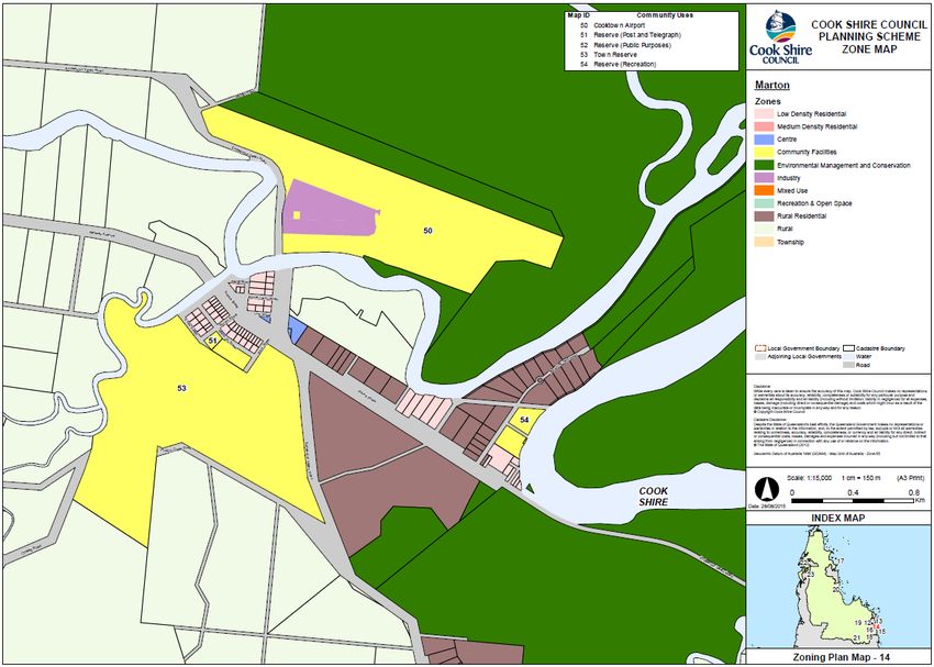
Short term

The following works are recommended for the short term period of 1-5 years:

    1.   Complete implementation of the Cooktown Airport Aviation Park (landside);

    2.   Construct taxiways to the Cooktown Airport Aviation Park (airside works);

    3.   Provide aeronautical facilities capable of supporting code 3C aircraft operations:

              o    Increase the runway and taxiway pavement bearing strength at the next significant
                   pavement overlay or maintenance activity; and

              o    Protect the future obstacle limitation surfaces applicable to a fully compliant code 3C
                   instrument non-precision aerodrome based on existing runway configuration;

    4.   Provide a functional and compliant passenger terminal;

    5.   Provide access roads and car parking in conjunction with the new passenger terminal;

    6.    Re-purpose the existing terminal as multi-use facility including for disaster response operations; and

    7.   Return the Airservices Australia lot to CSC.

Long term

The following works are recommended for completion by the end of the 20 year master planning period:

    1.   Provide aeronautical facilities capable of supporting code 3C aircraft operations:

              o    Establish a fully compliant 150 m wide runway strip (requires significant planning,
                   environmental and civil works, realignment of Endeavour Valley Road);

              o    Protect the obstacle limitation surfaces applicable to a fully compliant code 3C instrument
                   non-precision aerodrome OLS;

              o    Expand the main parking apron according to demand, and reconfigure other aircraft parking
                   arrangements as required;

              o    Consolidate fuel storage and dispensing facilities;

              o    Provide code B hangars in a precinct to the east of the main parking apron according to
                   demand; and

              o    Provide a parallel taxiway to the east of the main stub taxiway according to demand, and
                   relocate the primary wind direction indicator and signal circle.

Copies of the Master Plan drawings are provided at Figure E 1, Figure E 2 and Figure E 3.

A full sized copy of the Development Master Plan is provided at Annexure 1.

YCKN01-01 COOKTOWN AIRPORT DEVELOPMENT MASTER PLAN 2016

                                                                                                                   viii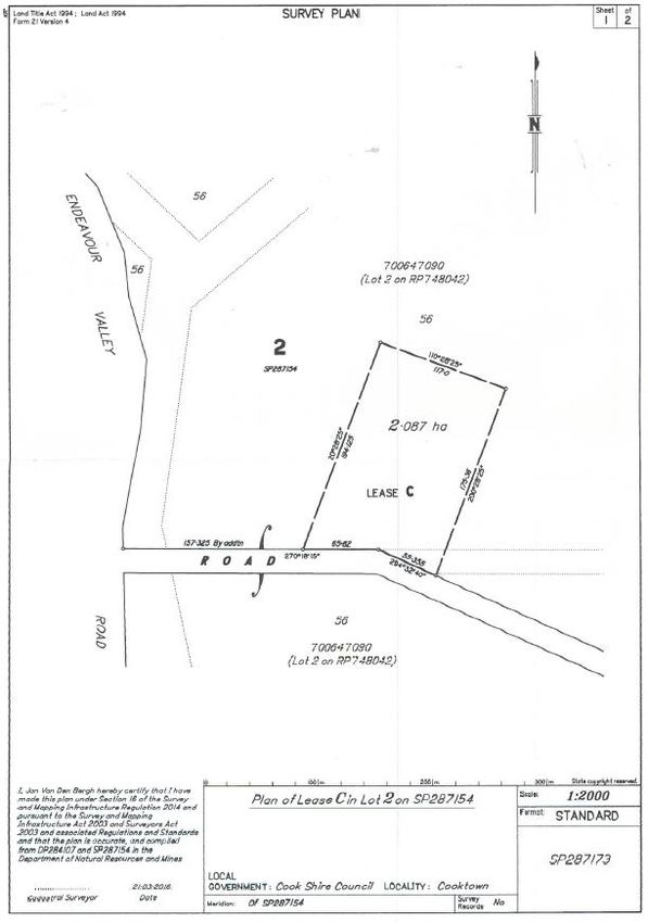
Figure E 1 Existing Airport Precinct

Figure E 2 Proposed Masterplan

YCKN01-01 COOKTOWN AIRPORT DEVELOPMENT MASTER PLAN 2016

                                                          ix
Figure E 3 Proposed Terminal Precinct Zone
YCKN01-01 COOKTOWN AIRPORT DEVELOPMENT MASTER PLAN 2016
x1. PLANNING CONTEXT
1.1. Background
Cook Shire is the largest shire in Queensland in terms of land area. From the Bloomfield River in the south to
just north of the Jardine River it covers over 100 000 square kilometres and occupies 80% of Cape York
Peninsula.
The major centre of Cooktown is located in the south eastern corner of Cook Shire, on the east coast of Cape
York Peninsula.
The relative location of Cooktown and Cook Shire is shown in Figure 1 (source: Qld Department of Local
Government, Infrastructure and Planning, Queensland Local Government Areas Boundaries, 16 March 2016).
Cooktown
Figure 1 Cook Shire Council boundaries
YCKN01-01 COOKTOWN AIRPORT DEVELOPMENT MASTER PLAN 2016
1Cooktown Airport is located to the west of Cooktown. A plan showing the location of the airport is shown in
Figure 2 (source: Google Earth).
Cooktown
Airport
S15.44
E115.18
Figure 2 Location Plan
Cook Shire Council (CSC) has committed to developing the aviation industry in Cooktown with the long term
goal of developing the Cooktown Airport and associated Aviation Park into a regionally significant aviation
precinct servicing Cape York and the Asia Pacific region.
The Cooktown Airport Aviation Park has preliminary approvals already in place to encourage private investment
into this industrial area and provide opportunities to further expand the aviation sector. The total land area on
offer is 7.5 hectares (ha) within a 10-minute drive from the town centre.
CSC was successful in obtaining $500,000 for the development of the Cooktown Airport Aviation Park through
the Building our Regions Fund. CSC will support a range of uses that meet existing and future demands with
the community and across a range of industries.
The preparation of a Development Master Plan (Master Plan) for Cooktown Airport is required to meet the
needs of CSC in providing a guiding document that will achieve Council’s long term goal in that it will provide a
direction for the aerodrome in terms of future infrastructure development and cost recovery, these being
balanced against the economic and social requirements and aspirations of the local community.
YCKN01-01 COOKTOWN AIRPORT DEVELOPMENT MASTER PLAN 2016
21.2. Site description
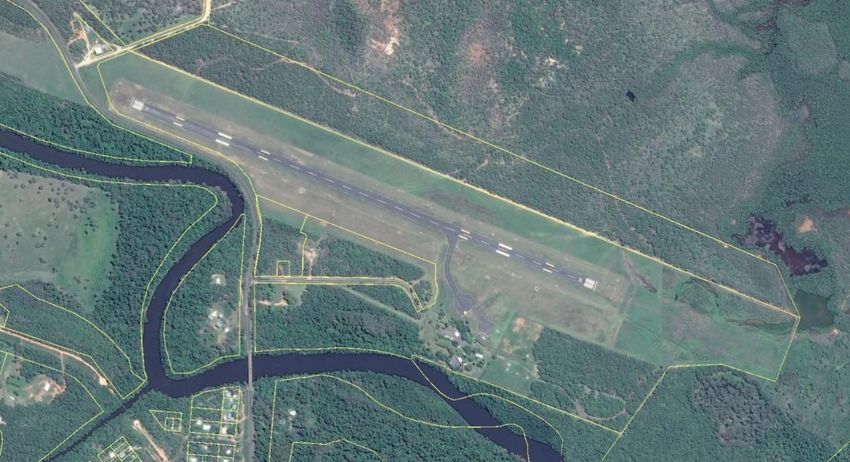
The existing airport site is comprised of Lots 1-3 on SP271395. A plan of the site is provided in Figure 3
(source: Google Earth and Qld Globe).
Figure 3 Site Plan
1.3. Regional characteristics
CSC Economic Profile 2015 provides some background information on the regional characteristics applicable
to this planning study.
1.3.1. Population
As at 30 June 2013, the resident population of CSC’s Local Government Area (LGA) was 4393. The
percentage increase from June 2012 was 1.85%. According to the 2011 Census QuickStats (by all
people, usual residents, State suburbs), the towns with the highest population in Cook Shire are
Cooktown (2339), Coen (416) and Bloomfield (403, including Rossville).
1.3.2. Economy
CSC’s Gross Regional Product has been growing at a steady rate despite the heavy impact of the
global financial crisis and high unemployment rate.
The Shire’s unemployment rate in September 2014 was 13.19%.
The largest changes by industry between 2006 and 2011 were seen in Public Administration and
Safety, resulting from the construction of several major government department buildings. The next
YCKN01-01 COOKTOWN AIRPORT DEVELOPMENT MASTER PLAN 2016
3census in 2016 will highlight some significant changes to this data which will reflect the amount of
building approvals and a noticeable population increase.
Trade and Investment Queensland, in its Market Profile – Far North Queensland, nominates Aviation
as one of the region’s economic strengths. It notes:
The aviation industry has grown steadily over the past 20 years and continues to
demonstrate strong growth, enhanced by the tourism industry. To support this, there are
many supply chain industries that include flight catering, engineering, trucking, logistics and
air transport. Equipment installation, maintenance and training have also been developed
to service the industry.
In its 2016 – 2020 Economic Development Plan, CSC nominated Aviation as an Emerging Industry,
and commits to supporting projects that will create a precinct of service delivery companies to meet
existing demand, across a range of industries. It notes:
As a coastal hub servicing most of the Cape York region (106,168m2 land area), Cooktown is
well positioned to offer new business and investment opportunities in this emerging industry.
1.3.3. Climate and meteorology
Cook Shire enjoys a mild tropical climate with the wet season running from January to March being
the hottest time of the year. April to December brings a drier period with cooler weather and
temperatures averaging around 27 degrees Celsius. In summer, Cooktown is usually 5 degrees cooler
than Cairns.
1.3.4. Regional aviation
Tourism and Events Queensland (TEQ) publishes the Tropical North Queensland (TNQ) Destination
Tourism Plan (DTP). The DTP is used to align the strategies, available resources and the efforts of
industry and all levels of government towards a set of unified long-term objectives.
The DTP states the following with respect to aviation in TNQ:
The Primary Drivers of growth will be led through Touring, Events and Aviation. These priorities will
only be successful if sufficient focus is also provided on Building the Context (Destination Image) and
the Enabling Drivers. These will be required to raise the profile and further develop the capacity of
the region to achieve and sustain the growth targets.
The DTP informs that inbound and outbound aviation capacity is approximately 2.5 million for
domestic and 533 000 international. Cairns Airport is the 7th busiest airport in Australia, and 6th
busiest for international passengers. It is estimated that approximately 48% of domestic arrivals and
65% of international visitors used air services to access the region.
International travel is available at Cairns and Townsville airports in the region. A map of international
destinations is shown in Figure 4.
YCKN01-01 COOKTOWN AIRPORT DEVELOPMENT MASTER PLAN 2016
4Figure 4 International destinations from TNQ
The DTP identifies the opportunity, threats and trends with respect to the potential aviation in the
region, which are provided in Table 1.
YCKN01-01 COOKTOWN AIRPORT DEVELOPMENT MASTER PLAN 2016
5Table 1 TNQ DTP aviation opportunity, threats and trends
Opportunities Threats Trend
Grow direct aviation capacity to Increased global Need to increase destination
Cairns to support increased competition awareness in target markets
demand from economic Government support required to
powerhouses in Asia, particularly attract and maintain regular
China flights
Region does not provide Increasing customer service
the required level of expectations and also the need to
service and experience thoroughly understand and meet
consistently across the the different cultural needs of the
region Asian markets
Four airlines conduct domestic RPT operations in the area: Qantas Link (Sunstate Airlines), Skytrans,
Regional Express (Rex) and Hinterland Aviation. Hinterland Aviation is the only RPT operator that has
Cooktown Airport as a destination.
Qantas Link (Sunstate Airlines) operates daily in the region with de Havilland Dash 8 400 (74 seats)
and Boeing 717-200 (up to 125 seats) aircraft in regular public transport (RPT) operations. The hubs
for the region are Cairns and Townsville, and destinations in the region include Horn Island, Weipa,
Cloncurry and Mount Isa.
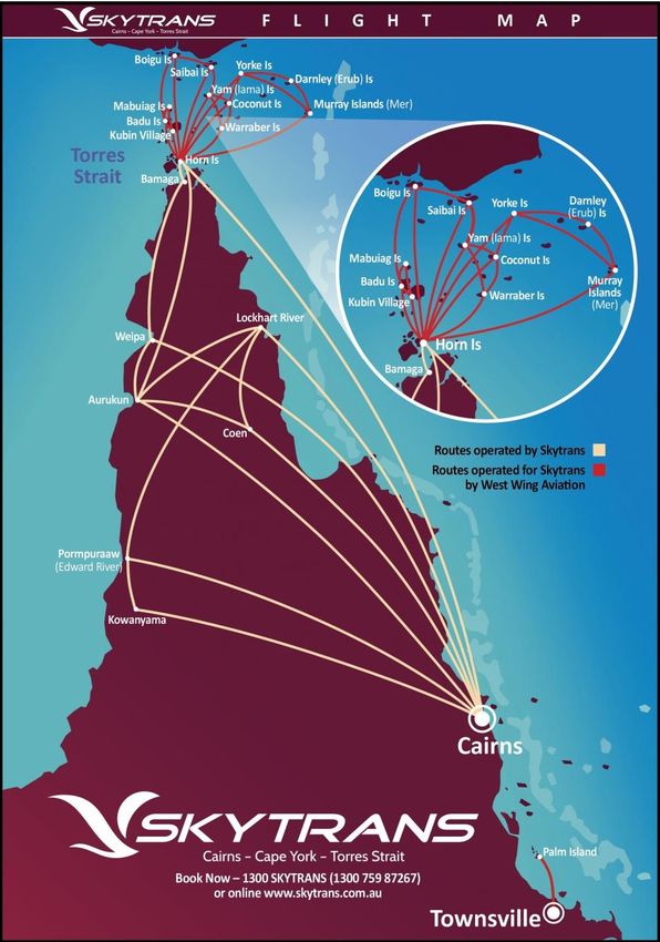
Skytrans operates daily in the region with de Havilland Dash 8 200 (36 seats) in RPT operations. A
map of Skytrans destinations is provided in Figure 5 (source: Skytrans website, retrieved 10 May
2016).
YCKN01-01 COOKTOWN AIRPORT DEVELOPMENT MASTER PLAN 2016
6Figure 5 Skytrans route map
YCKN01-01 COOKTOWN AIRPORT DEVELOPMENT MASTER PLAN 2016
7Rex operates daily in the region with SAAB 340 (34 seats) in RPT operations. A map of Rex
destinations is provided in Figure 6 (source: Rex website, retrieved 10 May 2016).
Figure 6 Regional Express Queensland regulated routes
YCKN01-01 COOKTOWN AIRPORT DEVELOPMENT MASTER PLAN 2016
8Hinterland Aviation operates 13 to 14 times per week between Cooktown and Cairns with Beechfraft
King Air 200 (11 seats) or Cessna 208 (12 seats) aircraft. Cairns is a 40-minute direct flight to the
major regional centre of Cairns. A map of the destinations is provided in Figure 7.
Figure 7 Hinterland Aviation destinations
Cooktown is strategically located to provide direct helicopter access to the tourist destination of Lizard
Island, and fixed wing flights to the northern and western extents of the Cape York Peninsula as well
as the nearby Asia Pacific region.
A map showing Cooktown Airport and other major airports in the region is provided at Figure 8
(source: OzRunways).
YCKN01-01 COOKTOWN AIRPORT DEVELOPMENT MASTER PLAN 2016
9Figure 8 Regional aeronautical situation map
1.4. Role and history
The first aerodrome constructed was at a mission on the existing site and was used regularly as far back as the
mid-1920s. This site is 17 km from town.
In 1936, CSC established a licensed aerodrome, 2 km west of the town on a low swampy area protected from
flooding by a levee bank. The Department of Aviation took over this aerodrome on 1 January 1938 and
remained in possession until 1949 when the aerodrome was decommissioned. During its brief life the
aerodrome was flooded three times despite the levee bank protection.
YCKN01-01 COOKTOWN AIRPORT DEVELOPMENT MASTER PLAN 2016
10The current site was taken over by the Royal Australian Air Force (RAAF) and the mission moved to Hopevale
some 32 miles distant, where the RAAF constructed a runway for fighters and bombers.
The then Department of Civil Aviation (DCA) was given permissive occupancy in December 1944 and
commenced to slowly develop the site which took on more impetus when the old town site was devastated by a
cyclone and flooding.
Actual ownership of the aerodrome was not transferred to DCA until June 1958. On 01 March 1992 Cooktown
Aerodrome transferred from the Department of Transport and Communications to the CSC.
1.5. Current operations
Cooktown Airport is a certified aerodrome equipped with non-precision instrument approaches and aerodrome
lighting capable of support aircraft under instrument flight rules day and night. The main runway 11/29 is
1627 m long and 30 m wide. It has a 90 m runway strip and is published as having code 2C instrument
non-precision obstacle limitation surfaces (OLS).
Operations at the Cooktown Airport generally comprise of:
regular public transport (RPT) services provided by Hinterland Aviation;
commercial charter services;
aeromedical retrieval by Royal Flying Doctor Service (RFDS) and Careflight Group (fixed and rotary
wing); and
other general aviation flying activities.
1.6. Strategic intent
CSC has a long term goal of developing the Cooktown Airport and associated Aviation Park into a regionally
significant aviation precinct servicing Cape York and the Asia Pacific region.
1.7. Purpose of master planning study
The purpose of the Master Plan is to establish a framework for the future planning and development of
Cooktown Airport to ensure CSC achieves its strategic objectives and capitalises on the aeronautical and
commercial opportunities provided by the airport.
The Master Plan is intended to establish the basis for more detailed studies of design, infrastructure planning,
land use planning and environmental impacts required to achieve the strategic direction.
1.8. Master planning outcomes
The Master Plan will provide a direction for the aerodrome in terms of future infrastructure development and
cost recovery, balanced against the economic and social requirements and aspirations of the local community.
A key aspect of the Master Plan will be the upgrading of the aerodrome as a code 3C airport and to protect this
rating during the airport’s and associated industrial estate expansion.
YCKN01-01 COOKTOWN AIRPORT DEVELOPMENT MASTER PLAN 2016
11Specifically, the Master Plan will address, to the extent possible, the following elements:
Current airport characteristics;
Airport standards and planning;
Air traffic forecasts;
Airport development plan; and
Commercial and business opportunities.
1.9. Planning horizons
The Master Plan nominally considers a planning horizon of 20 years, comprised of immediate, short term and
longer term timeframes:
Immediate – 12 months;
Short term – one-five years; and
Longer term Master Plan horizon – 20 years.
1.10. Previous planning studies
A number of planning studies have been conducted over the recent past:
Cooktown Airport Development Plan February 2005; and
Cook Shire Council Planning Scheme 2016.
1.11. Scope and Limitations
The results of the master planning study were limited to various extents by the following issues:
No detailed topographic survey data was available for evaluation;
No geotechnical data or other pavement design/construction data was available for evaluation;
No civil engineering aspects were required;
A runway usability analysis was not performed;
Aircraft noise impacts were not assessed; and
No cost estimates or financial models were prepared.
YCKN01-01 COOKTOWN AIRPORT DEVELOPMENT MASTER PLAN 2016
121.12. Methodology
This master planning study was undertaken using the following general methodology:
Preliminary work defined important baseline information that informed the planning task and the
work of the planning team;
Once the concepts were developed, a summary of preliminary planning concepts and the constraints
and limitations, opportunities and potential issues associated with various development scenarios
were presented for client review;
The First Draft Report and drawings/plans were prepared following review of the preliminary
concepts; and
A Final Draft Report and drawings/plans were submitted for client acceptance.
1.13. Stakeholder Consultation
CSC Councillors and staff members are the principal stakeholders for the purpose of consultation activities
undertaken during the preparation of the Master Plan, given the relative maturity of development plans already
prepared for the site.
Consultation undertaken was therefore principally with CSC personnel.
The final draft version of this Development Master Plan was presented to a meeting of the Airport Development
Community Forum at Cooktown Airport on 20 June 2016. Comments and recommendations made at that
meeting have been incorporated in the final document as appropriate.
Other stakeholders, including State and Commonwealth government agencies and aviation and associated
businesses based in Cooktown and/or Cairns were considered.
YCKN01-01 COOKTOWN AIRPORT DEVELOPMENT MASTER PLAN 2016
132. EXISTING AERODROME FACILITIES
2.1. Aeronautical infrastructure
Cooktown Airport is equipped with the aeronautical infrastructure described in this section.
Runway 11/29 is 1627 m x 30 m, with a 90 m wide runway strip.
Pavement bearing strength is noted in ERSA FAC as PCN 9/F/B/800 (116 PSI)/U Sealed.
Current runway declared distances are provided in Table 2 (source: ERSA RDS).
Table 2 Runway declared distances
TORA TODA ASDA LDA
Runway 11 1627 1687 (1.6%) 1627 1627
Runway 29 1627 1687 (2.5%) 1627 1627
A single 15 m wide taxiway connects the runway to the main parking apron.
The main parking apron provides a single parking position for up to Dash 8-300 sized aircraft. A small concrete
pad is provided adjacent to the refuelling facility for helicopter parking. Note that there are no markings on this
pad.
Beyond the main parking apron is a sealed and unsealed parking apron suitable for aircraft with maximum
take-off weight (MTOW)The airport is located outside controlled airspace, and has a common traffic advisory frequency (CTAF).
2.3. Landside development
Landside facilities include the following buildings:
Passenger terminal;
Airport Manager Office;
Airport works depot; and
Airport Manager residence.
2.4. Ground transport
Access to the airport is provided via a single sealed road originating at Endeavour Valley Road.
The existing main entrance road is a sealed, single lane road.
There are approximately 30 marked car parking spaces. Additional car parking is available in unmarked areas
in and around the terminal precinct.
YCKN01-01 COOKTOWN AIRPORT DEVELOPMENT MASTER PLAN 2016
153. DEMAND
Infrastructure requirements can only be scoped once demand for individual elements can be quantified over
the planning period. This then enables an integrated development strategy to be prepared.
Regional population growth, historical passenger demand, demand for aircraft parking and passenger terminal
capacity requirements are explored in the following section.
3.1. Regional population growth
At 30 June 2031, the population for the Cook Shire is projected to be 5527 persons. The population for the
region is projected to increase by an average annual growth rate of 1.1 per cent over the 20 year period
between 2011 and 2031.
Approved project developments as identified in the CSC Major Projects document could have a positive effect
on population numbers and this growth rate is likely to increase.
Projected populations at 30 June for Cook Shire and Tropical North Queensland are provided in Table 3
(Source: Queensland Government Population Projections (2013 edition) and Queensland Treasury and Trade
estimates).
Table 3 Projected populations by LGA, Cook Shire, 2011 to 2031
Local Government Area 2011 2016 2021 2026 2031 AAGR
Cook Shire 4409 4765 5037 5320 5527 1.1%
Tropical North Queensland 255 851 277 873 298 962 319 803 341 365 1.5%
3.2. Historical passenger demand
Department of Infrastructure and Regional Development produces annual airport passenger and aircraft
movements data. The passenger movements data for Cooktown Airport is provided in Figure 9 (source: Airport
Traffic Data 1985-86 to 2014-15 (xls format)).
According to the data, the average annual growth rate (AAGR) for the previous five years was -2.0%,
and -0.4%.for the previous 20 years.
A maximum annual total of 18 184 passengers was achieved in 2007-08, just prior to the Global Financial
Crisis (GFC).
YCKN01-01 COOKTOWN AIRPORT DEVELOPMENT MASTER PLAN 2016
16Figure 9 Annual passenger movements
3.3. Historical aircraft movement demand
Aircraft movements data for Cooktown Airport is provided in Figure 10 (source: Airport Traffic Data 1985-86 to
2014-15 (xls format)).
Figure 10 Annual aircraft movements
YCKN01-01 COOKTOWN AIRPORT DEVELOPMENT MASTER PLAN 2016
173.4. Forecast passenger demand
For the purpose of understanding potential future demand and infrastructure capacity requirements, the most
recent annual passenger movements total (2014-15) has been projected at three indicative AAGRs: 3%, 5%
and 10%.
Historical and projected population figures have been plotted, along with four times multiple of projected
population as a means of understanding the most likely maximum annual regular public transport passenger
movements.
Generally, it can be reasonably concluded that annual passenger movements at the 20 year planning horizon
are likely range between 15 000 and 25 000.
This analysis is shown graphically in Figure 11.
Figure 11 Passenger demand analysis
3.5. Aircraft parking capacity
The main parking apron provides sufficient capacity for a single design aircraft, or several smaller fixed and/or
rotary wing aircraft.
The secondary apron provides adequate sealed parking space for day to day operations.
The unsealed parking apron provides adequate overflow parking space for larger numbers of short term
itinerant operators.
The twice-daily operation of a Dash 8-400 aircraft at 80% load factor would produce 86 432 annual passenger
movements – well above the high range (10% AAGR) passenger projection shown in Figure 11. Alternatively,
YCKN01-01 COOKTOWN AIRPORT DEVELOPMENT MASTER PLAN 2016
18twice daily Dash 8-300 flights with the same load factor would produce 58 400 annual passenger movements.
Based on this analysis, the main parking apron is adequate for the needs of RPT operations.
The apron is not large enough to accommodate more than one large aircraft simultaneously, and given the
potential for concurrent operations by passenger transport and/or charter/private/aeromedical or other
aircraft, the higher strength main parking apron should be expanded to meet future needs.
3.6. Passenger terminal capacity
The passenger terminal is inadequate for existing needs, regardless of future passenger demand. It does not
provide an appropriate level of customer service, nor enable best practice security outcomes.
Ultimately, a new terminal facility should be able to accommodate the arriving and departing passengers of up
to two 68-74-seat aircraft such as the ATR72-600 or Dash 8-400, or a single 100-seat aircraft such as the
F100 or Bae146. At 80% load factor, this equates to a range of approximately 120-160 passengers, along with
associated meeters and greeters. A new passenger terminal could be designed to enable progressive
expansion according to demand.
YCKN01-01 COOKTOWN AIRPORT DEVELOPMENT MASTER PLAN 2016
194. DEVELOPMENT CONSTRAINTS
4.1. Planning
According to the Cook Shire Planning Scheme, the main airport site is zoned ‘Community Facility’, whilst part of
the site which is subject to lot reconfiguration is zoned ‘Industry’.
A copy of the applicable Zone Map is provided at Figure 12 (source: CSC).
Figure 12 Cook Shire Council Planning Scheme Zone Map
YCKN01-01 COOKTOWN AIRPORT DEVELOPMENT MASTER PLAN 2016
20The Marton Locality Code notes the following Overall Outcomes without specifying any Performance Criteria:
The purpose of this code is to achieve the following overall outcomes for the Marton Locality:
The township of Marton provides a basic range of services and facilities to residents,
tourists and to the surrounding rural area with higher order services and facilities being
located in Cooktown;
Marton provides limited opportunities for short-term visitor accommodation and for uses
which support the operation of the nearby airport;
New land uses and new buildings and structures do not compromise the operation of the
airport;
There is a general mix of land use typical of smaller townships, with non-residential uses
being limited in scale and designed so as not to compromise residential amenity; and
New buildings and land uses reflect the low density, spacious character and design of the
existing township.
A copy of the Marton Locality map is provided at Figure 13 (source: Cook Shire Planning Scheme, 1 June
2007).
Figure 13 Marton Locality
YCKN01-01 COOKTOWN AIRPORT DEVELOPMENT MASTER PLAN 2016
21At the time of preparing this Plan, in order to establish lots within the Aviation Park, it was proposed to
consolidate the individual lots within the Aviation Park into Lot 1, and identify the applicable area as available
for subdivision by metes and bounds descriptions according to relevant planning provisions/codes, as per
Lease C within Lot 2 of RP 287154, depicted in Figure 14 (source: Cook Shire Council).
Development conditions and constraints may need to be established in applicable planning instruments and
prospectus in order to ensure that development achieves the desired aviation purposes.
Figure 14 Lease C in Lot 2 RP 287154
YCKN01-01 COOKTOWN AIRPORT DEVELOPMENT MASTER PLAN 2016
224.2. Regulatory context
Current and future operations at Cooktown Airport are regulated according to the requirements set out in the
section below.
4.2.1. Civil Aviation Safety Regulations 1998
Civil Aviation Safety Regulation 1998 (CASR) Part 139—Aerodromes describes the requirements for
aerodromes used in air transport operations.
4.2.2. Manual of Standards Part 139—Aerodromes
Manual of Standards Part 139—Aerodromes (MOS 139) sets out the standards and operating
procedures for certified, registered and certain other aerodromes used in air transport operations.
4.2.3. Aerodrome reference code
Australia has adopted the International Civil Aviation Organisation (ICAO) methodology of using a code
system, known as the Aerodrome Reference Code, to specify the standards for individual aerodrome
facilities which are suitable for use by aeroplanes within a range of performances and sizes. The Code
is composed of two elements: element 1 is a number related to the aeroplane reference field length;
and element 2 is a letter related to the aeroplane wingspan and outer main gear wheel span. Table 4
is a copy of MOS 139 Table 2.1-1: Aerodrome Reference Code.
Table 4 MOS 139 Table 2.2-1 Aerodrome Reference Code
Code Element 1 Code Element 2
Code Aeroplane reference field Code Wing span Outer main gear wheel span
number length letter
1 Less than 800 m A Up to but not Up to but not including 4.5 m
including 15 m
2 800 m up to but not including B 15 m up to but not 4.5 m up to but not including 6 m
1200 m including 24 m
3 1200 m up to but not C 24 m up to but not 6 m up to but not including 9 m
including 1800 m including 36 m
4 1800 m and over D 36 m up to but not 9 m up to but not including 14 m
including 52 m
E 52 m up to but not 9 m up to but not including 14 m
including 65 m
F 65 m up to but not 14 m up to but not including 16 m
including 80 m
YCKN01-01 COOKTOWN AIRPORT DEVELOPMENT MASTER PLAN 2016
234.3. Design Standards
CSC desires an aerodrome that will ultimately conform to standards applicable to code 3C instrument
non-precision requirements as specified in MOS 139.
A summary of current and future physical characteristics and OLS requirements for code 3C instrument
non-precision operations is provided in Table 5.
Table 5 Physical Characteristics and OLS Design Criteria
ASPECT Current Master Plan
Code 2C Code 3C
instrument non- instrument non-
precision precision
Minimum runway length 1627 m 1627 m (as is)
Minimum runway width 30 m 30 m
Runway strip width - graded 80 m 90 m
Total runway strip width (includes flyover) 90 m 150 m
Runway strip length (beyond runway) 60 m 60 m
Runway end safety area 60 m 90 m
Taxiway separation from runway 63 m 93 m
Taxiway width 15 m 15 m
Taxiway strip width (total) each side of CL 26 m 26 m
Taxiway strip width (graded) each side of CL 12.5 m 12.5 m
Taxilane separation from object 24.5 m 24.5 m
Approach Surface Width inner edge 90 m 150 m
Divergence 15% 15%
Length 2500 m 15 000 m
Gradient 3.33% 3.3%
Dist from threshold 60 m 60 m
T/O Climb Surface Width inner edge 80 m 180 m
Divergence 10% 12.5%
Length 2500 m 15 000 m
Gradient 4% 2%
YCKN01-01 COOKTOWN AIRPORT DEVELOPMENT MASTER PLAN 2016
244.4. Environmental
There are no environmental studies for this area; however, as part of the Queensland Government Department
of Infrastructure, Local Government and Planning (DILGP) State Planning Policy (SPP), there are guidelines that
involve vegetation clearing in general and particularly adjacent to river banks (40 m).
Consideration will need to be given to the potential for flooding, the close proximity of the site to adjacent
waterways and sensitive vegetation such as mangroves, and the potential for effluent and other run-off to
damage the Great Barrier Reef.
4.5. Heritage
There are no heritage studies available; however, as part of the SPP, there are guidelines that involve heritage
issues. The SPP also references the UNESCO World Heritage Centre Interactive Mapping, which indicates that
the area is part of the Wet Tropics of Queensland.
It should be recognised that there may be some indigenous culture and European heritage issues that will need
to be investigated as part of future development, particularly on the southern side of the airport access road.
4.6. Other development control measures
Other development measures which should be considered include:
The National Airport Safeguarding Framework; and
State Planning Policy.
YCKN01-01 COOKTOWN AIRPORT DEVELOPMENT MASTER PLAN 2016
255. AIRCRAFT MOVEMENT AREAS
5.1. Runway
The runway in its current form is accepted as satisfactory for the master planning horizon and is not planned to
be changed.
5.2. Runway pavements
The existing runway pavement may require strengthening in order to accommodate the larger and heavier code
3C design aircraft. Further detailed pavement design work, based on geotechnical investigation results, will
inform the scope and cost of this work.
5.3. Runway usability
An important consideration in the orientation, siting and number of runways at an aerodrome is runway
usability with respect to the distribution of wind. Runway usability was not formally investigated, but the current
orientation is assumed to be acceptable.
5.4. Taxiways
The existing stub taxiway is acceptable for access to the main parking apron, but may require reconfiguration
according to apron expansion requirements.
A new stub taxiway is planned for connection of the new development sites to the runway and a parallel taxiway
that will join the existing stub taxiway.
5.5. Parking aprons
The existing parking aprons are not considered adequate for the number and various sizes of aircraft
contemplated at the master plan horizon.
The main parking apron will require expansion and strengthening to accommodate up to three code 3C aircraft,
along with a number of smaller code B aircraft within a co-located code B hangar precinct.
5.6. Hangar facilities
Three code B hangars are proposed alongside the expanded main parking apron.
5.7. Helicopter facilities
Helicopter parking stands are planned for the main parking apron in front of the refuelling facility and in the
transient parking area to the front of the main apron area.
YCKN01-01 COOKTOWN AIRPORT DEVELOPMENT MASTER PLAN 2016
265.8. Aerodrome lighting
The aerodrome ground lighting system is serviceable.
The primary illuminated wind direction indicator (IWDI) will ultimately need to be relocated when the parallel
taxiway is extended to the east of the existing stub taxiway.
YCKN01-01 COOKTOWN AIRPORT DEVELOPMENT MASTER PLAN 2016
276. AVIATION SUPPORT FACILITIES
6.1. Fuel
The existing fuel dispensing system may need to be consolidated with storage facilities in a single compound to
allow expansion of the main parking apron.
6.2. Ground support equipment
Ground support equipment is normally provided according to aircraft operator requirements and not
considered applicable to this Master Plan.
6.3. Navigation and approach aids
The straight-in RNAV (GNSS) approaches currently available are considered adequate for the intended scope of
operations.
6.4. Weather information service
The weather information service provides actual weather data via landline telephone connection.
Ideally the weather station should also broadcast weather information to pilots via an airband radio broadcast
transmitter.
6.5. Aerodrome rescue and fire fighting services
CASR 1998 Part 139 Subpart H sets out the requirements applicable to provision of aerodrome rescue and fire
fighting services (ARFFS). According to these regulations, ARFFS must be provided at an aerodrome from or to
which an international passenger air service operates; and any other aerodrome through which more than
350 000 passengers passed on air transport flights during the previous financial year.
This situation is not expected during the master planning period.
6.6. Air traffic control and airspace
The aerodrome is currently located within non-controlled Class G airspace and no air traffic control (ATC)
services are provided. There is no reason to expect this situation would change in the 20 year planning period.
6.7. Transport security
Cooktown Airport is a security controlled aerodrome. If an aircraft greater than 20 000 kg MTOW is scheduled
to operate at Cooktown Airport or if the security threat level is raised by the relevant government agency,
security screening will be required. Aviation Security Identification Cards must be displayed by personnel whilst
airside.
YCKN01-01 COOKTOWN AIRPORT DEVELOPMENT MASTER PLAN 2016
287. PASSENGER FACILITIES
7.1. Aeromedical facilities
There is no requirement to provide any additional aeromedical facilities.
7.2. Passenger terminal
A new passenger terminal is recommended for construction to the west of the existing facility with direct airside
access, sufficient to accommodate at least 120-160 arriving and departing passengers plus meeters and
greeters.
The community desires preservation of the relaxed tropical feel of the terminal precinct and entrance
statement through sensitive design and landscaping.
YCKN01-01 COOKTOWN AIRPORT DEVELOPMENT MASTER PLAN 2016
298. COMMERCIAL LAND USE AND DEVELOPMENT
8.1. Current leasing and charging regime
CSC is currently leasing industrial zoned land for aviation purposes along the northern boundary of the airport
access road.
CSC sets the fees and charges for Cooktown Airport.
According to the schedule of Fees and Charges 2015-16, the following charges apply:
Landing fee (fixed wing) per movement per tonne: $13.00 including GST;
Landing fee (helicopter) per movement per tonne: $6.50 including GST;
Car parking (nightly): $6.50 incl GST; and
Car parking (weekly): $30.00 incl GST.
Car parking charges apply to secure car parking in the workshop compound only. Car parking in the terminal
car park is free of charge.
CSC staff reported experiencing difficulty in enforcing and collecting the car parking fees.
8.2. Current airport management structure
The airport is owned and operated by CSC. An Airport Manager lives on site, and is assisted by aerodrome
reporting officers and other CSC staff.
The current airport management structure is satisfactory for the short to medium term, but may require
revision as and when the scope of operations changes in the future.
8.3. Future commercial and business prospects
The main opportunity for commercial development is additional hangars for business or private aircraft
operations, whether in the Aviation Park or in the code B hangar precinct identified for development on the
eastern side of the main parking apron.
Opportunities such as those listed below (source: 2016-2020 Economic Development Plan, draft) may arise in
the future:
Vehicle storage area – 4WD, RV, caravan, car (secure area);
Vehicle hire – 4WD, car;
Aircraft/ helicopter maintenance centre/ operator;
Heavy vehicle/ car service centre;
Bulk storage – domestic/ commercial storage;
YCKN01-01 COOKTOWN AIRPORT DEVELOPMENT MASTER PLAN 2016
30 Business centre; and
Training centre – aviation, indigenous training.
8.4. Managing and implementing development plan
Management of the Cooktown Airport Development Master Plan will be the responsibility of the Director of
Infrastructure Services, Cook Shire Council.
From the Master Plan, a staged implementation plan will be developed with the aim of having the identified
infrastructure and airport classification in place by 2026.
YCKN01-01 COOKTOWN AIRPORT DEVELOPMENT MASTER PLAN 2016
31You can also read