Transportation Plan - Bowen Island Municipal
←
→
Page content transcription
If your browser does not render page correctly, please read the page content below
Transportation
     Plan
2 0 1 8-2 0 3 8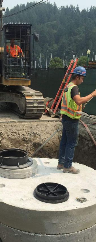
Transportation Plan 2018-2038

A special thank you to the dedicated
Working Group for the Integrated             Table of Contents
Transportation Master Plan (ITMP) project.
This Transportation Plan was made
possible through the long hours, hard work      EXECUTIVE SUMMARY       IV
and steadfast enthusiasm that this team
contributed to this project. Thank you to:      INTRODUCTION             1
Lisbeth Haigh-Turner
David Hocking                                   VISION                   3
Melanie Mason
Richard Smith                                   BACKGROUND               8
                                                PLAN                    16
                                                Active Transportation   19
                                                Transit21
                                                Regional Connections    22
                                                Alternative Modes       23
                                                Parking25
                                                Multi-Modal Integration 26

                                                IMPLEMENTATION          27
                                                EVALUATION              53
                                                APPENDICES              57
Transportation Plan 2018-2038                                                                                                                                                                Introduction

Executive Summary                                                                                             Introduction                            In 1999, Bowen Island Municipality incorporated
                                                                                                                                                      as a small rural community with rudimentary
                                                                                                                                                      transportation operations. Over the years, the
In 2015, the Municipality embarked on creating             schedules between BC Ferries, TransLink,           MISSION                                 island has stayed rural and is still celebrated for
the first Transportation Plan for the island. This         and other service providers. The Plan also                                                 its natural beauty. More recently, a variety of
20-year Plan is the product of over two years              includes many elements to build pedestrian         To create an efficient and              transportation issues were being raised by the
of planning and stakeholder engagement. The                and cycling networks, improve road safety,         sustainable transportation              community.
Plan is built on a community vision of “simple,            optimize and expand transit service, encourage
seamless, sustainable transportation options for           alternative options, streamline access to
                                                                                                              system for the island by                KEY CONCERNS
every Bowen Islander”. This vision encompasses             regional destinations, and advocate for better     integrating planning for multiple       People were concerned about lack of
the three main goals of the Plan to have better            accessibility on- and off-island.                  modes of transportation, land           connections and choices, and impacts on public
transportation connections, choices, and health.                                                                                                      health and the environment. They wanted to see
                                                           The Plan organises these elements in a strategic   use, and demand management.             an integrated transportation system that would:
There are many islanders who often rely                    approach by first developing the infrastructure
on walking or cycling and often encounter                  and establishing more options, then promoting                                               ➼➼Facilitate walking and cycling
accessibility issues. Engagement and data                  sustainable travel behaviour.                                                               ➼➼Optimise bus service
collection identified that one of the greatest                                                                                                         ➼➼Coordinate regional connections
transportation gaps for the island is lack of safe         The Transportation Plan is a living document                                                ➼➼Improve Cardena Rd pedestrian safety
and efficient active transportation infrastructure,        with annual reports to track progress and help                                              ➼➼Increase alternative ways to get around
along with need for more options to help reduce            inform minor adjustments to better achieve Plan                                             ➼➼Manage Snug Cove parking
greenhouse gas emissions.                                  goals. In 10 years, a comprehensive review of                                               ➼➼Integrate different modes of travel
                                                           the Transportation Plan should be undertaken                                               In recent years, new opportunities have
Priority projects over the next 20 years will              to determine any need to revise the community                                              developed in technology, funding, and regional
be a cross-island multi-use path, pedestrian               vision or goals.                                                                           partnerships to help address these concerns.
improvements to Cardena Dr, and coordinated                                                                                                           The time had come to invest in transportation
                                                                                                                                                      planning to focus efforts and take advantage of
                                                                                                                                                      arising opportunities.

                                                                                                                                                      TAKING ACTION
                                                                                                                                                      In 2015, the Municipality initiated the Integrated
                                                                                                                                                      Transportation Master Plan (ITMP) project to
                                                                                                                                                      develop the island’s first ever transportation plan.
                                                                                                                                                      This plan would provide strategic guidance over
                                                                                                                                                      the next 20 years for policies, development, and
                                                                                                                                                      public investment related to transportation for
                                                                                                                                                      Bowen Island.

                                                      iv                                                                                          1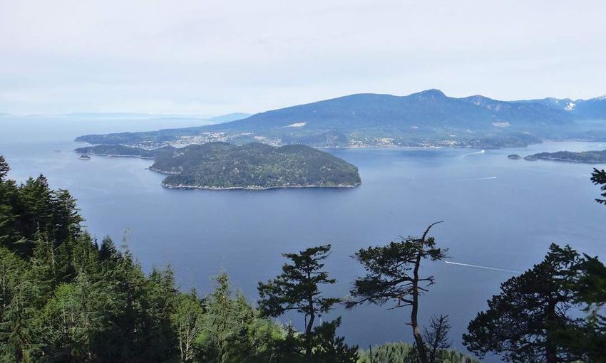
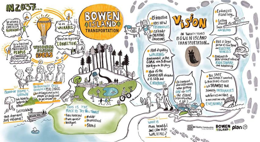
Transportation Plan 2018-2038                                                                                                                                                                                    Vision

MAKING OF THE TRANSPORTATION
PLAN                                                                                                       Vision                                                  infrastructure, transit service, alternative options
                                                                                                                                                                   and regional connections.
The Plan was completed over two years by the                                                               WHAT WE WANT…
ITMP Working Group, a sub-committee of the                                                                 The community vision for Bowen Island                   Online Poll
                                                                                                                                                                   Throughout 2016, an on-line poll was open on
Transportation Advisory Committee (TAC).                                                                   transportation was crafted from the Official
                                                                                                                                                                   the project website asking people to select
Through five phases, the project reviewed                                                                  Community Plan (OCP), ITMP project
                                                                                                                                                                   top transportation improvement priorities.
existing plans and studies, gathered background                                                            engagement, and public comment to Council and
                                                                                                                                                                   66 people voted, with almost half choosing
data, engaged stakeholders, developed                                                                      the TAC over the years.
                                                                                                                                                                   walkability, followed by cycling and accessibility
alternatives, and prepared the final plan.
                                                                                                           OFFICIAL COMMUNITY PLAN                                 at 23% and 20%, respectively. Accessibility
Community involvement was very important                                                                   The OCP chapter on transportation prioritizes           refers to the ability for everyone, regardless
throughout the planning process. Over 1,000                                                                active transportation, safety, more alternatives,       of ability or special needs, to access, use, and
people were engaged to help develop this                                                                   integration, and reducing environmental                 benefit from their environment.
Plan, with almost a year of dedicated public                                                               impacts. The document contains 25 policies
engagement including:                                                                                      directly related to transportation. Every one           Information Sessions Poll
                                                                                                                                                                   During the three public information sessions,
                                                        Engagement has been instrumental for               of these policies draw on the need to better
 ➼➼A citizen questionnaire                                                                                                                                         paper votes were submitted for transportation
                                                        establishing a community vision, and determining   accommodate active transportation on the
 ➼➼Three public information sessions                                                                                                                               priorities. Almost half of votes were for active
                                                        key priorities for improvement and public          island. About half reference the design of the
 ➼➼A multi-stakeholder workshop                                                                                                                                    transportation, followed by transit at 19%, and
                                                        investment. The Transportation Plan builds         road network, with a specific policy to include a
 ➼➼Four neighbourhood meetings                                                                                                                                     alternative options and parking both at 17%. The
                                                        on the ideas generated from the community,         paved pedestrian path or sidewalk along all main
 ➼➼First Nations consultation                                                                                                                                      majority of comments specifically asked for a
                                                        informed with data, analysis, research and best    roads. Five policies involve land use planning to
 ➼➼A pop-up booth                                                                                                                                                  multi-use path across the island.
                                                        practices.                                         create more walkable environments.
 ➼➼Two open houses
Additional comments were submitted through              The Transportation Plan is organised as follows:   PUBLIC ENGAGEMENT OUTCOMES                              Investment Priorities
                                                                                                                                                                   The multi-stakeholder workshop identified
the project website and key contact (phone,                                                                Engagement results have highlighted key areas
                                                                     VISION – what we want                                                                         common investment priorities across stakeholder
email, and physical address). All key stakeholder                                                          to be addressed, primarily active transportation
groups were engaged, including residents,                        BACKGROUND – what we have
business owners, visitors, service providers, and
external agencies. The Citizen Questionnaire                       PLAN – what we need to do
was essentially an origin-destination survey that
                                                               IMPLEMENTATION – how we do it
provided much of the travel pattern data cited in
this Plan.                                                      EVALUATION – keeping on track

                                                                                                                                              Figure 1 - ITMP on-line poll results

                                                    2                                                                                                          3
Transportation Plan 2018-2038                                                                                                                                                                                        Vision

                                                          as well as the traditional territory of the            THE COMMUNITY VISION                                    destinations. Transit will run in the evenings,
                                                          xməθkəyəm (Musqueam), Tsleil-Waututh                   In 20 years, Bowen Island transportation will           seamlessly integrate with the ferry and water
                                                          and shishalh (Sechelt). The island has been            epitomize island living. Getting around will be         taxis, and serve more areas. Electric and low-
                                                          historically frequented by these First Nations         simple and relaxed. This means options that             speed vehicles will be common on the island.
                                                          for hunting, fishing and, later, wage jobs.            are efficient, healthy, safe and environmentally-       Bowen’s strong sense of community will continue
                                                          Transportation initiatives in this Plan may provide    conscious.                                              to foster a robust culture of hitchhiking and
                                                          opportunities to acknowledge and celebrate                                                                     ridesharing.
                                                                                                                 Pedestrians, cyclists and equestrians of all
                                                          Aboriginal traditional knowledge through naming
                                                                                                                 ages and abilities will have safe and direct            For those that choose to drive, sufficient parking
                                                          of key sites or routes, interpretive signage, public
                                                                                                                 connections to neighbourhoods and key                   will be available at the village periphery to
                                                          art, and continued collaboration with local First
Figure 2 - ITMP Information Sessions poll results         Nations, especially in the design of the Bowen                                                  VISION STATEMENT
groups. These priorities were a multi-use path,           Island portion of the North Shore Spirit Trail.
improved transit and better regional connections.                                                                            Simple, seamless, sustainable transportation options for every
The highest priority location for a multi-use path                Figure 3 - Community vision for Bowen Island transportation                       Bowen Islander.
was along Grafton Rd from Mount Gardner Rd
to Grafton Lake. There was also support for a
variety of alternative transportation options such
as low-speed vehicles and ridesharing.

Neighbourhood Concerns
Discussion meet-ups were held in four different
neighbourhoods across the island, yielding
local insight on transportation issues and
opportunities. The west side of the island would
like more destinations for “purposeful walking”,
such as shops and services, and also safer walking
and cycling connections to the local beaches.
The south of the island would like to see more
parking in the Cove, a water taxi to Seymour
Bay, and a Park & Ride serving the area. Eastern
neighbourhoods voiced concerns for pedestrian
and cyclist safety, especially at night, as well as
requests for “on-demand” style of transit service.

First Nations Consultation
Bowen Island is located within the Skwxwú7mesh
(Squamish) unceded core traditional territory,

                                                      4                                                                                                              5
Transportation Plan 2018-2038                                                                                                                                                                                        Vision

maintain a high-quality walking environment                accessibility, inclusiveness, autonomy, efficiency,
within the village core. The Cardena intersection,         and climate change mitigation.                        STRATEGY #2: CHOICES
being the transportation hub of the island, will
be safe and enjoyable to navigate for all users.           STRATEGIC GOALS                                       To provide a real choice for people to get around involves having viable alternatives to the
                                                           This Plan is built upon three strategies for the
Getting on and off the island, especially without a                                                              private automobile. This strategy aims to support and encourage development of alternative
                                                           community vision encompassing three main
car, will be convenient and affordable.                                                                          transportation options that are fitting for Bowen Island.
                                                           goals:
Finally, islanders will not shy away from innovation                                                             Key elements of this strategy include providing infrastructure for active transportation, facilitating
and new technologies. Bowen Island will be a                1. CONNECTIONS – Shorter trips, fewer trips          alternative modes like scooters, electric vehicles and horses, designing for accessibility, and
role model in creative transportation solutions             2. CHOICES – When you want, how you want             encouraging private enterprises like taxis and car sharing. Accessibility refers to the ability for
that further the values of the community: safety,                                                                everyone, regardless of ability or special needs, to access, use, and benefit from their environment.
                                                            3. HEALTH – Fewer emissions, better health
                                                                                                                 Regional partnerships will also play an important role since a large portion of Bowen Island trips
                                                                                                                 include off-island travel. For many alternative options to be viable on the island, they must be well-
                                                                                                                 integrated into off-island transportation systems.
  STRATEGY #1: CONNECTIONS

                                                                                                                 STRATEGY #3: HEALTH
  To effectively connect people and places require efficient, integrated networks so that trips are
  shorter in time and distance. This strategy focuses on developing active transportation networks,
                                                                                                                 To have transportation that is healthy for people and the environment means a system that
  improving upon the existing road network, and strengthening connections to regional networks.
                                                                                                                 encourages active modes, reduces harmful emissions and facilitates access to health care,
  Key elements of this strategy include a cross-island multi-use path as part of larger pedestrian               especially for those that cannot drive. This is a two-pronged strategy that promotes more walking
  and cycling networks, with a proper wayfinding system. The result will be efficient active                     and cycling trips, while enabling fewer and shorter private automobile trips, especially single-
  transportation connections from residential neighbourhoods to the village.                                     occupancy ones.

  Road standards will be updated to facilitate the development of these networks and provide                     Key elements of this mode include improving safety of active modes, promoting walking and
  more balanced use of road space. Potential inclusion in TransLink’s Major Road Network will give               cycling, supporting low emission options, and demand management to reduce automobile
  access to annual funding for road improvements and maintenance to meet the new standards.                      dependency. Awareness, education, and promotion campaigns will be critical parts of this strategy.
  Also, forming local and regional partnerships will help strengthen off-island networks with more               Essentially, the first two strategies will lay the groundwork to make more sustainable transportation
  coordinated and direct access to key destinations.                                                             possible. This third strategy will spur the cultural shift that will make the community vision a reality.

                                                       6                                                                                                            7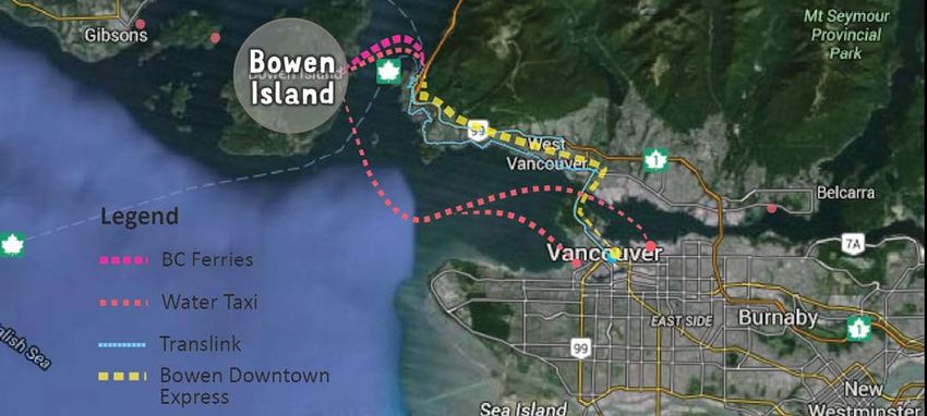
Transportation Plan 2018-2038 Background
BACKGROUND of climate change mitigation and public health.
However, Bowen Island has a relatively car-
Current Networks
Bowen Island has about 75 km of public roads,
The island has two TransLink community shuttle
flagstop routes - C10 and C11, recently renamed
WHAT WE HAVE… dependent transportation system, with very little most of which are paved with little or no 280 and 281, respectively. These routes connect
Bowen Island is a municipality located in Howe active transportation infrastructure or alternative shoulders. The maximum speed on the island is major residential areas to Snug Cove, running
Sound, about six kilometres off the coast of West options.2 40 km/h. ICBC crash data shows relatively few at basic service levels and following the ferry
Vancouver. The island has 3,6801 permanent trouble areas, with the most reported incidents schedule. The shuttles have accessibility issues
residents and approximately 1,500 seasonal Greenhouse Gases at the intersections of Bowen Island Trunk Rd & and do not have GPS capability for real-time
Based on a 2003 report3, transportation
residents. The population contains a significant Miller Rd, and Grafton Rd & Adams Rd. tracking.
accounted for 90% of Bowen Island’s greenhouse
number of youth and seniors. Covering about
gas (GHG) emissions. This is mostly from
50 square kilometres, the land is generally Figure 5 - Map of current vehicle networks
off-island and ferry transportation. Key
mountainous and over half is protected natural
Current Island Transportation
±
recommendations to help achieve target
space. Development is predominantly low
emission levels included developing an active
density residential on the east and west coasts.
The village of Snug Cove, located on the east
coast, contains most of the island’s shops and
transportation and transit strategy, increasing
viability of transit use on mainland, and improving
Vehicle
services, as well as the only ferry terminal. efficient usage of ferry car-capacity.
Network
In 2017, Council approved a Community Energy
Being an island presents unique transportation Prepared: March 16, 2018
and Emissions Plan (CEEP) containing actions
challenges. In addition to on-island networks,
to reduce GHG emissions from transportation,
water connections are needed to access off-
namely shifting to more active modes and
island destinations. Once on the mainland,
efficient vehicles, especially electric4.
there is a high reliance on transit and alternative
transportation options for those that walk on 2 Bowen Island Community Health Profile, My Health My
the ferry or take water taxis. Modes other than Community, 2015
3 Bowen Island Community Energy Planning Options, Pembina
driving are especially encouraged in the interest Institute, 2003
1 2016 Census of Canada, Statistics Canada. 4 Bowen Island Community Energy and Emissions Plan, 2016
Road Classification
Figure 4 - Transportation share of GHG emissions Trunk Road
Main Road
Residential Road
Service Road
Byway
Unclassified
TransLink Route
C10
C11
0 400 800 1,600 2,400 3,200
Meters
8 9
Transportation Plan 2018-2038                                                                                                                                                                            Background

  There is no dedicated active transportation             Cardena Dr at Bowen Island Trunk Rd is the          The main connection to the mainland is a               Horseshoe Bay zone in March of 2017. There are
  infrastructure on the island, with the exception        transportation hub of the island, being the nexus   20-minute BC Ferries route from Snug Cove to           no other car sharing companies in the area.
  of half a kilometre of sidewalks along the main         of traffic and passenger exchange for the ferry,    Horseshoe Bay. The ferry runs almost every hour
                                                                                                                                                                     Longstanding alternative transportation options
  road to the ferry terminal. There is an informal        transit, school, information centre, marinas, and   between 5:30 AM and 10 PM. Passenger-only
                                                                                                                                                                     that work well on Bowen are motorcycles,
  requirement for a gravel shoulder on main roads,        trailheads. The paved road here is narrow and       water taxis provide additional connections with
                                                                                                                                                                     scooters, hitchhiking, and a Jack Bell vanpool to
  and no shoulder requirement for all other roads.        littered with informal parking spaces. There is     regular weekday service to Horseshoe Bay and
                                                                                                                                                                     the University of British Columbia. The vanpool
                                                          inadequate space for bus turnaround, and a lack     Coal Harbour. Water taxis also provide charter
                                                                                                                                                                     vehicle is in need of replacement, but funds are
                                                          of safe, accessible pedestrian connections.         services to destinations in the greater region.
                                                                                                                                                                     no longer available for a new vehicle.
                          Figure 6 - Map of current active transportation networks                            On the mainland, two TransLink bus routes
                                                                                                                                                                     There appears to be an adequate supply
                                                                                                              connect Horseshoe Bay with Park Royal in West

                                                                                                ±
                                                                                                                                                                     of public parking spaces in the Cove with
Current Island Transportation                                                                                 Vancouver and with downtown Vancouver.
                                                                                                              An Independent Transit Service, the Bowen              approximately 130 long-term and 92 short-term.
                                                                                                                                                                     In addition, there are 61 private pay parking
Active                                                                                                        Downtown Express, provides a peak hour
                                                                                                              route direct to downtown Vancouver. There              spaces. All public spaces are free and number
                                                                                                                                                                     of spaces generally exceed demand. In Spring of
Networks                                                                                                      are no direct routes to North Vancouver from
                                                                                                              Horseshoe Bay.                                         2017, a Municipal long-term lot was strategically
Prepared: March 9, 2018                                                                                                                                              located in the village periphery to improve the
                                                                                                              A valuable regional connection for many Bowen          pedestrian environment and encourage more
                                                                                                              Islanders has been car sharing company car2go          walking.
                                                                                                              in Horseshoe Bay. However, car2go canceled its

                                                                                                                                              Figure 7 - Map of regional networks

                                                                             Legend
                                                                             Pedestrian Network
                                                                                   Sidewalk
                                                                                   Trail
                                                                                   Footpath
                                                                                   Crosswalks
                                                                                   Structures
                                                                                   Bike Parking

                                                             0   395 790   1,580   2,370   3,160
                                                                                              Meters

                                                     10                                                                                                         11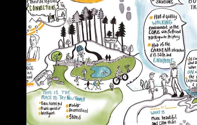
Transportation Plan 2018-2038                                                                                                                                                                                        Background

TRAVEL PATTERNS                                           Artisan Square, Tunstall beach, Mount Gardner       second most common reason to travel is for               (about 40%). The mode share for walking and
About half the current population is located              trailheads, and the golf course.                    errands and the top destination is Snug Cove,            cycling is relatively high (about 20%) compared
on the east side and a quarter is on the west                                                                 followed by the Knick Knack Nook/Recycling               with the region, especially for commute trips.5
                                                          Main reason for trips is commuting (to work or
side. Key destinations on the island include the                                                              Depot, and the Bowen Building Centre.                    The largest sources of driving are work trips on
                                                          school), especially for off-island trips. Since
residential neighbourhoods on the east and west
                                                          there is no high school on the island, almost all   People mostly drive (53% overall), although              5 Bowen Island Community Health Profile, My Health My
sides, the ferry terminal, Snug Cove, Bowen Island                                                                                                                       Community, 2015
                                                          high school age children board the 7:30 am ferry    significantly less do for trips going off-island
Community School (BICS), the recycling depot,
                                                          to transit to school in West Vancouver. The
                                                                                                                                                   Figure 9 - Summary of trip purpose
                                   Figure 8 - Map of activity nodes

 Activity Nodes
 Prepared: March 9, 2018
                                                                                                ±

                                                                                                                                                  Figure 10 - Summary of mode share

                                          *                         *
                                                                               LEGEND
                                                                                      Residential
                                                                                      Economic
                                                                                      Recreation
                                                                                      Institutional
                                                                                      Transportation

                                                 **                           *       Potential Node

                                                                0   395 790   1,580   2,370   3,160
                                                                                                 Meters

                                                     12                                                                                                           13
Transportation Plan 2018-2038 Background
the island and errands trips both on- and off- About two-thirds of trips involve portions off- Community Needs Figure 12 - Map of designated land uses
island. About a quarter of people indicate they island. Top destinations off-island are North and The island’s land use designations mainly allow
have used alternative transportation, chiefly West Vancouver and City of Vancouver, mostly for low density residential use. Commercial and
Designated Land Uses
Prepared: March 9, 2018
±
motorcycles and scooters. downtown. Visitor traffic mainly goes toward institutional uses are almost entirely designated
the west coast beaches, up Mount Gardner Rd to in Snug Cove and Artisan Square.
The main travel patterns on Bowen consist of Killarney Lake and trailheads, or south to the golf
AM/PM waves of commuters and students Current development activity is focused around
course.
along the main roads to and from Snug Cove. the southern neighbourhood of Cowan Point, and
a rezoning for significant density increase is in
Figure 11 - Map of traffic patterns progress for the Grafton Lake area in the centre
of the island. Island population is projected to
Traffic Patterns
±
Designated
increase by 700 over twenty years, a moderate Land Uses
Low Density Residential
average annual growth of 1.24%, most of which is Mid Density Residential
Natural
Prepared: March 9, 2018
expected to be young families. Institutional
Commercial
Industrial
With the expected growth and development,
0 387.5 775 1,550 2,325 3,100
travel patterns would be impacted with Meters
increased traffic volumes along Grafton Rd, and Figure 13 - Map of expected growth areas
intensification of traffic at BICS and Cardena Dr.
Improvements for walking and cycling for these
areas will be a top community need, especially
Expected Population
Growth Areas
±
Prepared: March 9, 2018
since community feedback showed more
people prefer to walk or cycle than actually do
(33% versus 20%). The main reason cited for
not walking or cycling is lack of safe, accessible
infrastructure. Similar reasons are mentioned
for alternative options such as scooters and
vanpools. Bowen Island needs to be innovative
to support and increase transportation by modes
Address Locations
other than the private single-occupancy vehicle. by Year
Key area of expected Year 2000
And lastly, the planned redevelopment of the Year 2016
future traffic increase Year 2030 (estimated)
Horseshoe Bay and Snug Cove terminals in
0 395 790 1,580 2,370 3,160
5-10 years will also impact travel patterns. The
Meters
terminals will need better accessibility and
modal integration, especially with active transportation. Redevelopment will present opportunities to
0 395 790 1,580 2,370 3,160
Meters
address these issues and help fundamentally shift travel behaviours.
14 15Transportation Plan 2018-2038 Plan
PLAN
WHAT WE NEED TO DO…
This section presents the strategic elements alternative modes, parking, and multi-modal
needed to transform the island’s existing integration. These components will be improved
transportation system into the simple, following the three strategies laid out in the
seamless and sustainable community vision. Vision section of this Plan: 1) connections, 2)
The components of the vision are active choices, and 3) health.
transportation, transit, regional connections,
Figure 14 - Transportation Plan concept
ACTIVE TRANSIT REGIONAL ALTERNATIVE PARKING INTEGRATION
CONNECTIONS
Guidelines rvice rds
Design R sit Se ion
Trana Expans
Elec a
Sta oad Passenger Ferries t
Infra ric Vehic tand
nda Are
rds Sch
struc l
ture e adS
Major Road o
Part ol-Tra nal Ro Cardena
Network ners nsit
hip e gio s Pedestrian
R n er
Cardena e to atio & S coot Safety
Multi-Use Passenger vic sti
n Bike arking
Path er De P Cardena
Ped Exchange S
Passenger
What What
Car Sharing
Ne estri Exchange
tw an Regional Partnerships Comm
ork u
Parkin ter
ble g e
we we
g
yclin rk nsi
t rom A c cessi ection nates
C ra
eT s o / F l Conn d i
Re Sp two Saf cces ns T hoo Ferry or ul
du ee Ne B A O ptioigh Sc Coched
ct d Cardena us H S
have want
io Yi Support
n Pedestrian el Alternative Park & Ride
Safety d in
Footpath g Coordinate Schedules Options Incentives
Pa Reg
ve n rtn io
xi Lighting
cti n Pla er nal C
om n
E
on
sh
s
A
st ol io
ho at
Real-Time Ho ip i o
ing
Cond iti Sc port Transit Tracking Ac rsesh
ces oe Acce Pa
rki
ng s mun
ity Vis
ns Pass ssibilit
Tra sib Bay Comm y
en ilit ittee y Pa
Ferri ger de
& Rives
y
es a r k i Accessibility
P ent Committee
Cycling Promotion Inc
20-YEAR TRANSPORTATION PLAN
16 17Transportation Plan 2018-2038 Plan
Table 1: Summary of plan elements
ACTIVE TRANSPORTATION
An integral part of the community vision, active transportation will help provide more travel
options, increase physical activity, reduce chronic disease, and help mitigate climate change.
Active transportation may also benefit tourism and social equity. Therefore, a large part of this Plan
involves facilitating and encouraging active transportation.
Firstly, the island needs more infrastructure that accommodates safe and efficient walking and
cycling. This can be created through retrofitting existing roads and updating development
requirements for new roads.
A1 - Active Transportation Design Develop and adopt active transportation design guidelines
for new development.
Guidelines
Update Subdivision & Development Servicing Bylaw to have
A2 - Road Standards
road standards that accommodate pedestrians and cyclists.
Design and construct a cross-island multi-use path that
A3 - Multi-Use Path
accommodates pedestrians, cyclists and equestrians. This
path is part of the North Shore Spirit Trail.
Networks should also be developed specifically for pedestrians and cyclists, including proper
wayfinding and end-of-trip facilities like bike parking.
Construct and improve critical footpaths to connect
A4 - Pedestrian Network
neighbourhoods to important destinations.
Designate cycling routes and install bike facilities at
A5 - Cycling Network
strategic locations to better enable cycling across island.
Design and install dedicated bike and scooter parking with
B9 - Bike & Scooter Parking
shelter.
18 19Transportation Plan 2018-2038 Plan
ACTIVE TRANSPORTATION TRANSIT
Reliable annual funding should be established to enable the construction and maintenance of the Closely connected with active transportation, transit also reduces GHG emissions and provides an
above infrastructure. affordable transportation option, especially for longer distances. Currently, transit is underutilized,
especially on-island. Feedback has shown that convenience is one of the main considerations
Apply to TransLink for inclusion in the Major Road Network,
A6 - Major Road Network in whether to use transit. This includes distance to bus routes, reliability and coordination of
which provides municipalities with annual funding for
schedules, and time of travel.
operation and rehabilitation of roads.
In addition to dedicated networks, safety is essential for active transportation to be a viable option. Steps should be taken to advocate for more service areas.
Develop and implement program to effectively establish Advocate for investigating service expansion to growing
A8 - Speed Reduction C1 - Transit Service Area
and regulate traffic speeds. demand areas such as Cowan Point, Queen Charlotte
Expansion
Include pedestrian safety improvements in the Heights, Cates Hill, and future developments.
A9 - Cardena Pedestrian Safety
redevelopment of Cardena Dr. Investigate viability of partnership with school bus service.
C7 - School-Transit Partnership
Develop and implement program, compliant with Night Sky
B4 - Footpath Lighting
Bylaw, to improve lighting for pedestrian network. Getting to the bus needs to be safe. This is largely addressed by the active transportation elements
Lastly, education and awareness will further improve safety and encourage more people to walk listed above, but targeted improvements can be made to ensure safe access to transit.
and cycle. Improve transit pick-up/drop-off areas.
A10 - Cardena Passenger
Work with BC Ferries to shift focus from vehicles to
A12 - Alternative Ferries Exchange
passengers. Collaborate with TransLink and ICBC to improve safety of
Advocate and foster regional transportation planning B8 - Safe Transit Access
B3 - Regional Partnerships transit access.
partnerships to help identify best practices, opportunities
Scheduling improvements should positively impact the user experience and encourage more
for collaboration and potential funding.
transit use both on- and off-island.
Develop ongoing cycling promotion strategy to include
B5 - Cycling Promotion
events, education and awareness. Help coordinate schedules between BC Ferries, TransLink
A7 - Coordinate Schedules
B11 - School Active Transportation Partner with BICS to develop a School Active Transportation and the water taxis.
Plan. Enforce vehicular traffic yielding to buses, especially at
Plan A11 - Bus Yielding
terminal.
Support development and implementation of technology
B2 - Real-Time Transit Tracking
to access real-time transit information, such as location and
expected time of arrival.
20 21Transportation Plan 2018-2038 Plan
TRANSIT REGIONAL CONNECTIONS
In addition to network and service improvements, some transit promotion will help further increase To enable many of the elements pertaining to the greater region will require strong, collaborative
ridership. working relationships with regional partners.
Advocate and foster regional transportation planning
C5 - Park & Ride Incentives Implement incentives to promote and encourage use of B3 - Regional Partnerships
partnerships to help identify best practices, opportunities
Park & Ride facility.
for collaboration and potential funding.
Connections to the mainland are limited. Efforts should be taken to explore additional options.
Work with BC Ferries to shift focus from vehicles to
A12 - Alternative Ferries
passengers , and to consider using electric ferries.
Advocate for more frequent and better coordinated
B12 - Service to Regional
connections between key destinations in North and West
Destinations
Vancouver. Also, explore rail connection for Sea-to-Sky
corridor.
Develop additional options for high school students to
C3 - Options To/From High School
travel between West Vancouver and Bowen Island.
Advocate for and explore car sharing opportunities in
C4 - Car Sharing
Horseshoe Bay.
Streamlining transportation will be critical for regional connections. Regular efforts need to be
made to coordinate and optimize available options.
Help coordinate schedules between BC Ferries, TransLink
A7 - Coordinate Schedules
and the water taxis to reduce waiting times and encourage
ridership.
Advocate for improved accessibility to, from and within
C2 - Horseshoe Bay Accessibility
the Horseshoe Bay Terminal, and for better connections to
TransLink services.
REGIONAL CONNECTIONS
Being an island community, regional connections are an unavoidable part of life. Seamless ALTERNATIVE MODES
integration of transportation options here is particularly important to reduce wait times and travel
costs, and avoid getting stranded. Also, given the large majority of GHG emissions are from ferry Transportation options for islanders are quite limited, contributing to high automobile dependency.
and private vehicle use on the mainland, reduction of both these modes will greatly benefit climate Community feedback has brought forward many ideas for alternatives to single-occupancy private
change mitigation. vehicle use. Some of these ideas will require infrastructure changes.
22 23Transportation Plan 2018-2038 Plan
ALTERNATIVE MODES PARKING
B7 - Electric Vehicle Develop electric vehicle infrastructure and install public Parking strategies are a common tool of travel demand management. Balancing parking availability
Infrastructure charging station(s). and costs can effectively shift mode share from driving to other modes such as walking, cycling,
Design and install dedicated bike and scooter parking with
B9 - Bike & Scooter Parking transit or alternative transportation.
shelter.
B10 - Accessible Ferry Connection Install an accessible pick-up/drop-off area closer to ferry B7 - Electric Vehicle Develop electric vehicle infrastructure and install public
ramp. charging station(s).
Infrastructure
C2 - Horseshoe Bay Accessibility Advocate for improved accessibility to, from and within B9 - Bike & Scooter Parking Design and install dedicated bike and scooter parking with
the Horseshoe Bay Terminal, and for better connections to shelter.
TransLink services. Implement incentives to promote and encourage use of
C5 - Park & Ride Incentives
Some ideas require new types of service provision. Park & Ride facility to reduce parking demand in Village.
Long-term parking should be located on the periphery to maintain the pedestrian environment of
Work with BC Ferries to shift focus from vehicles to
A12 - Alternative Ferries the village.
passengers, and to consider using electric ferries.
Advocate for and explore car sharing opportunities in
C4 - Car Sharing B6 - Commuter Parking Shift public commuter parking to periphery of village.
Horseshoe Bay.
In general, the Municipality should endeavour to foster alternative transportation ideas and provide Cost of providing free parking spaces is significant and unfair to taxpayers that do not use them. A
support wherever possible. pay parking system would be more equitable and help fund parking improvements.
Encourage alternative transportation enterprises, such as
B1 - Support Alternative Options C6 - Pay Parking Implement public pay parking in the village and use revenue
taxis, scooter rentals and sharing rides. to fund improvements, maintenance and enforcement.
Appoint an Accessibility Committee to advise on
C8 - Accessibility Committee
accessibility improvements and develop accessible design
policies.
24 25Transportation Plan 2018-2038 Implementation
IMPLEMENTATION
HOW WE DO IT…
The implementation of the Transportation Plan
will be overseen and guided by the TAC. The
schedule and estimated budget is laid out by
year for each plan element, followed by key step-
by-step actions including responsible roles and
MULTI-MODAL INTEGRATION potential funding. TAC will prepare an annual
work plan with identified priority projects for
The overall theme of this Plan is integration across all transportation modes to truly achieve a Council approval.
system that is simple, seamless, and sustainable. This applies to transportation on- and off-island,
active modes, transit, regional connections, alternative modes, and parking. TIMELINE
Update Subdivision & Development Servicing Bylaw to The Plan will be carried out over 20 years, with
A2 - Road Standards
include requirements for transportation impact studies both operational and capital elements (Table 2).
for significant new developments, and road standards that Due to limited resources, new infrastructure will
accommodate pedestrians and cyclists. be constructed incrementally over the 20-year
Help coordinate schedules between BC Ferries, TransLink timeline.
A7 - Coordinate Schedules
and the water taxis.
Include pedestrian safety improvements in the BUDGET
A9 - Cardena Pedestrian Safety The Transportation Plan has a total estimated
redevelopment of Cardena Dr.
budget of $3.29 million over 20 years (Table4-7).
Improve transit pick-up/drop-off areas.
A10 - Cardena Passenger Almost 90% of the budget is for active
Exchange transportation infrastructure, most of which is
Advocate and foster regional transportation planning
B3 - Regional Partnerships eligible for 50-75% cost sharing from external
partnerships to help identify best practices, opportunities agencies. Operating costs are minimal, mainly
for collaboration and potential funding. to cover partnership and safety initiatives, as
Appoint an Accessibility Committee to advise on
C8 - Accessibility Committee well as maintenance and repair of the new active
accessibility improvements and develop accessible design transportation networks and facilities. Potential
policies. funding is estimated at $1.58 million, which would
result in a Municipal cost share estimate of $1.7
SPECIAL PROJECTS million. This equals just over $85,000 per year.
Three site-specific projects are already scheduled for the next 20 years that may provide oppor- Implementation of capital projects will require
tunities to help achieve the goals of the Plan: 1) Cardena Improvements, 2) Snug Cove Ferry Termi- inclusion in the Five-Year Financial Plan, along
nal Redevelopment, and 3) Horseshoe Bay Ferry Terminal Redevelopment. Special consideration with subsequent annual budget approval by
should be taken to align these projects with the Plan and advocate for inclusion of plan elements. Council.
26 27Transportation Plan 2018-2038 Implementation
Table 2: Transportation Plan timeline Table 3: Special Projects timeline
PLAN ELEMENT 2018 2019 2020 2021 2022 2023-27 2028-38 SPECIAL PROJECT 2018 2019 2020 2021 2022 2023-27 2028-38
HIGH PRIORITY CARDENA IMPROVEMENTS
A2 Road standards A6 Major road network
A6 Major road network A11 Bus yielding
A11 Bus yielding B6 Commuter parking
A1 Active transportation design guidelines A9 Cardena pedestrian safety
A9 Cardena pedestrian safety A10 Cardena passenger exchange
A10 Cardena passenger exchange A4 Pedestrian network
A12 Alternative Ferries A5 Cycling network
A3 Multi-use path B4 Footpath lighting
A4 Pedestrian network B7 Electric vehicle infrastructure
A5 Cycling network B8 Safe transit access
A7 Coordinate schedules C6 Pay parking
A8 Speed reduction B3 Regional partnerships
MID PRIORITY SNUG COVE TERMINAL REDEVELOPMENT
B2 Real-time transit tracking BC Ferries community engagement
B6 Commuter parking BC Ferries terminal plans
B9 Bike & scooter parking BC Ferries terminal construction
B11 School active transportation plan A3 Multi-use path
B12 Service to regional destinations A4 Pedestrian network
B1 Support alternative options A5 Cycling network Municipality to consider
Elements to be
B3 Regional partnerships A11 Bus yielding complementary
considered during
Electric vehicle infrastructure
B7 Electric vehicle infrastructure infrastructure or
B7 engagement
B9 Bike & scooter parking facilities if necessary
B4 Footpath lighting
B8 Safe transit access
B5 Cycling promotion
B10 Accessible ferry connection
B8 Safe transit access B3 Regional partnerships
B10 Accessible ferry connection
HORSESHOE BAY TERMINAL REDEVELOPMENT
LOWER PRIORITY BC Ferries community engagement
C1 Transit service area expansion BC Ferries terminal plans
C2 Horseshoe Bay accessibility
BC Ferries terminal construction
C8 Accessibility committee A7 Coordinate schedules
C5 Park & ride incentives
Municipality to
A12 Alternative Ferries
C3 Options to/from high school
Elements to be Review plans consider
B1 Support alternative options
C4 Car sharing
considered during for inclusion complementary
C2 Horseshoe Bay accessibility
Options to/from high school
engagement of elements infrastructure or
C7 School-transit partnership C3
C4 Car sharing facilities if necessary
C6 Pay parking
Annual Progress Report B3 Regional partnerships
Travel Survey Capital work
Plan Review Operational work
Capital work
Operational work
28 29Transportation Plan 2018-2038 Implementation
Table 4: Transportation Plan budget summary
Table 5: Capital budget Table 6: Operating budget
TRANSPORTATION PLAN CAPITAL BUDGET TRANSPORTATION PLAN OPERATING BUDGET
ELEMENT YEAR ELEMENT YEAR
ID PLAN ELEMENT ID PLAN ELEMENT
BUDGETS 2018 2019 2020 2021 2022 2023-27 2028-38 BUDGETS 2018 2019 2020 2021 2022 2023-27 2028-38
HIGH PRIORITY $2.9 M HIGH PRIORITY $235 k
A1 Active transportation guidelines $0 A1 Active transportation guidelines $20,000 $20,000
A2 Road standards $0 A2 Road standards $0
A3 Multi-use path $2,160,000 $25,000 $335,000 $250,000 $250,000 $300,000 $500,000 $500,000 A3 Multi-use path $57,000 $2,000 $15,000 $40,000
A4 Pedestrian network $250,000 $25,000 $25,000 $25,000 $25,000 $25,000 $125,000 A4 Pedestrian network $72,500 $500 $1,000 $1,500 $2,000 $17,500 $50,000
A5 Cycling network $100,000 $5,000 $5,000 $5,000 $5,000 $5,000 $25,000 $50,000 A5 Cycling network $22,000 $100 $200 $300 $400 $4,500 $16,500
A6 Major road network $0 A6 Major road network $0
A7 Coordinate schedules $0 A7 Coordinate schedules $20,000 $1,000 $1,000 $1,000 $1,000 $1,000 $5,000 $10,000
A8 Speed reduction $0 A8 Speed reduction $34,000 $2,000 $2,000 $10,000 $20,000
A9 Cardena pedestrian safety $250,000 $250,000 A9 Cardena pedestrian safety $3,800 $200 $200 $200 $200 $1,000 $2,000
A10 Cardena passenger exchange $150,000 $150,000 A10 Cardena passenger exchange $0
A11 Bus yielding $0 A11 Bus yielding $1,000 $1,000
A12 Alternative ferries $0 A12 Alternative ferries $5,000 $5,000
MID PRIORITY $85 k MID PRIORITY $26 k
B1 Support alternative options $0 B1 Support alternative options $0 $0 $0 $0 $0 $0 $0 $0
B2 Real-time transit tracking $0 B2 Real-time transit tracking $1,000 $1,000
B3 Regional partnerships $0 B3 Regional partnerships $10,000 $500 $500 $500 $500 $500 $2,500 $5,000
B4 Footpath lighting $5,000 $5,000 B4 Footpath lighting $0
B5 Cycling promotion $0 B5 Cycling promotion $12,000 $1,500 $500 $500 $3,500 $6,000
B6 Commuter parking $30,000 $30,000 B6 Commuter parking $0
B7 Electric vehicle infrastructure $10,000 $10,000 B7 Electric vehicle infrastructure $0
B8 Safe transit access $10,000 $10,000 B8 Safe transit access $0
B9 Bike & scooter parking $10,000 $10,000 B9 Bike & scooter parking $0
B10 Accessible ferry connection $10,000 $10,000 B10 Accessible ferry connection $0
B11 School active transportation plan $10,000 $10,000 B11 School active transportation plan $0
B12 Service to regional destinations $0 B12 Service to regional destinations $2,500 $500 $500 $500 $500 $500
LOWER PRIORITY $30 k LOWER PRIORITY $6 k
C1 Transit service area expansion $0 C1 Transit service area expansion $1,000 $1,000
C2 Horseshoe Bay accessbility $0 C2 Horseshoe Bay accessbility $1,000 $1,000
C3 Options to & from high school $0 C3 Options to & from high school $1,000 $1,000
C4 Car sharing $0 C4 Car sharing $1,000 $1,000
C5 Park & ride incentives $0 C5 Park & ride incentives $1,000 $1,000
C6 Pay parking $30,000 $30,000 C6 Pay parking $0
C7 School-transit partnership $0 C7 School-transit partnership $500 $500
C8 Accessible transportation $0 C8 Accessible transportation $0 $0 $0 $0 $0 $0 $0 $0
ANNUAL BUDGET TOTALS $505 k $375 k $285 k $280 k $330 k $700 k $550 k ANNUAL BUDGET TOTALS $3 k $24 k $6 k $7 k $9 k $63 k $156 k
CAPITAL TOTAL $3,025,000 OPERATING TOTAL $266,300
Shaded amounts may be cost shared by external funding
30 31Transportation Plan 2018-2038 Implementation
Table 7: Potential funding IMPLEMENTATION DETAILS construction. And, lastly, annual evaluation
Ongoing efforts to ensure transportation options reports will be essential to track progress, keep
are integrated, coordinated and adequate will the Plan on schedule, and proactively identify any
require regular meetings and collaboration with issues or concerns that may require attention.
the community, service providers, and regional
The information in this section is meant to help
partners. Infrastructure projects will require
TAC develop the annual work plan. A template
timely completion of planning, funding, budget
for the work plan is available in Appendix D.
approval and design to ensure successful
HIGH PRIORITY ELEMENTS
A1 Active transportation design guidelines
What is intended Guidelines should be adopted as a policy to ensure that all new
development addresses the requirements of the Plan, as well as considers
opportunities for improving active transportation within and connecting
to the site.
Key actions 1. 2018 Summer – Planning apply for funding (e.g. Federation of
Canadian Municipalities (FCM) Staff Support Grants)
2. 2018/19 Winter – Council approve budget
3. 2018/19 Winter –Planning research and draft guidelines
4. 2019 Summer – TAC review guidelines
5. 2019 Fall - Council adopt guidelines
A2 Road standards
What is intended A Subdivision & Development Servicing Bylaw is an important tool for
a proactive approach to integrated transportation. This Bylaw may
require a proposed development with significant traffic impact potential
to submit a transportation impact study to help determine the type
of transportation infrastructure needed within and connecting to the
development. This Bylaw also specifies the road standards to which the
new infrastructure is built. Standards should comply with Transportation
32 33Transportation Plan 2018-2038 Implementation
HIGH PRIORITY ELEMENTS HIGH PRIORITY ELEMENTS
Association of Canada’s Geometric Design Guide for Canadian Roads. Key actions 1. Q1 - TAC initiate Phase
Road standards should align with best practices to reallocate more (annually) 2. Q2 - Public Works preliminary design
road space to pedestrians and cyclists. Standards should also consider
3. Q4 - Planning apply for funding (e.g. TransLink BICCS/WITT, BikeBC,
improvements for safety of active modes on the roadway, including
FCM)
signage, pavement markings, and intersection treatments.
Key actions 1. 2017/18 Winter – Planning & Public Works draft Bylaw 4. Q1 - Council approve budget
2. 2018 Spring – Council adopt Bylaw 5. Q2 - Public Works construct and maintain
Figure 15 - Map of multi-use path phasing
A3
±
Multi-use path
Phasing for Multi-Use Path
What is intended A cross-island multi-use path was a top priority for investment and
Prepared: March 9, 2018
infrastructure improvement from the ITMP engagement. The path routing
was based on community feedback and feasibility. The phasing was
based on highest need in terms of safety and network connection.
As of 2017, this path has been included in the North Shore Spirit Trail.
Path standards have been included in A2 Roads Standards taking into
consideration safety and inclusivity, expected usage, environmental
impacts, available resources, and the Spirit Trail standards.
New developments along the identified multi-use path route
must contribute their portions of the path (i.e. Grafton Lake Lands
development). Portions may also be constructed by utility companies as
part of their infrastructure upgrade projects.
PHASING
Wherever possible, pedestrian or cyclist counters should be installed Phase 1
to evaluate usage. In addition, wayfinding elements such as signage and Phase 2
pavement markings should be incorporated into the multi-use path to Phase 3
improve safety, efficiency, user experience, and sense of place. Refer to Phase 4
Appendix A for the Bowen Island Spirit Trail Wayfinding Strategy. Phase 5
Developer (TBD)
The estimated operational budget is for spot repairs and line painting. It BC Hydro
does not include any snow removal, sanding or sweeping, which are costly SCIWG
and research has shown that similar rural municipalities have not needed Potential Loop
to provide these services. 0 395 790 1,580 2,370 3,160
Meters
34 35Transportation Plan 2018-2038 Implementation
HIGH PRIORITY ELEMENTS HIGH PRIORITY ELEMENTS
Table 8: Multi-use path phasing details Figure 16 - Map of proposed pedestrian network
Proposed Pedestrian Network
±
PHASE EXPECTED
START
START END LENGTH EXISTING (km) COST
DATE NONE SHOULDER TRAIL ESTIMATE
BC Hydro 2018 Bowen Island Bowen Island 433 - - $216,500
Trunk Rd/Miller Trunk Rd/Mount
Prepared: March 9, 2018
Rd Gardner Rd
1 2018 Grafton Rd/670
Cates Ln
Grafton
Rd/Charlie's Ln
361 - - $361,000
2 2020 728 Grafton Rd 800 Grafton Rd 136 228 - $215,800
Developer 2020 800 Grafton Rd Grafton - 998 - $349,300
Rd/Harding Rd
3 2023 Bowen Island
Trunk Rd/Mount
Grafton Rd/670
Cates Ln
- 732 - $256,200
Gardner Rd
SCIWG 2025 Ferry Terminal Bowen Island 331 - 88 $183,100
Trunk Rd/Miller
Rd
4 2026 Grafton
Rd/Harding Rd
Grafton
Rd/Adams Rd
- 932 106 $347,400
5 2030 Grafton
Rd/Adams Rd
Adams
Rd/Tunstall Blvd
- 869 806 $465,350
A4 Pedestrian network
What is intended The multi-use path will be the spine of the pedestrian network, with
connections to neighbourhoods and key destinations via trails, footpaths,
sidewalks and structures such as stairways and bridges. Community Proposed
MUP
feedback has identified several high priority areas, as shown in the
Existing MUP_Loop
following map. New development along a proposed route must
Sidewalk Sidewalk
contribute that portion of the network. Budget should be allocated
Trail Trail
annually for the development and maintenance of the network. Footpath Footpath
Key actions 1. Q1 - TAC establish on-road priority projects Crosswalks Crosswalks
(annually) 2. Q1 - Parks, Trails & Greenways Advisory Committee (PTGAC)
Structures Structures
establish off-road priority projects 0 400 800 1,600 2,400 3,200
Meters
3. Q2 - Public Works preliminary design
4. Q4 - Planning apply for funding (e.g. TransLink WITT)
5. Q1 - Council approve budget
6. Q2 - Public Works construct and maintain on-road portions
7. Q2 - Parks construct and maintain off-road portions
36 37Transportation Plan 2018-2038 Implementation
HIGH PRIORITY ELEMENTS HIGH PRIORITY ELEMENTS
A5 Cycling network Figure 17 - Map of proposed cycling network
What is intended The multi-use path will be the spine of the cycling network, with facilities
to enable access and transition to other modes. Secondary bikeways will
be clearly marked shared lanes. These will generally be on uphill lanes.
Proposed Cycling Network
Prepared: March 9, 2018
±
New development along a proposed route must contribute that portion
of the network. Budget should be allocated annually for the development
and maintenance of the network. 5
13
Key actions 1. Q1 - TAC establish on-road priority projects 6 4
11 3
(annually) 2. Q1 - Parks, Trails & Greenways Advisory Committee (PTGAC) 21
7
0
10
8
establish off-road priority projects FID addressStr
5 0 Ferry Shelter
3. Q2 - Public Works preliminary design 13 1 473 Bowen Island Trunk Rd
6
3 4 21 7 0 2 Village Square
3 Artisan Square
4. Q4 - Planning apply for funding (e.g. TransLink WITT) 10 4 Bowen Island Community School
5 Recycling Depot
5. Q1 - Council approve budget 6
7
Island Pacific School
Library
8 Mount Gardner Rd at Killarney Lake
6. Q2 - Public Works construct and maintain on-road portions 9 Tunstall Bay
10 Municipal Dock - Snug Cove North
11 Hikers Trail Rd at Mount Gardner Rd
7. Q2 - Parks construct and maintain off-road portions 12 Golf Course
13 (Proposed) Bike Park
14
A6
14 Park & Ride
Major Road Network
9
What is intended In 2017, TransLink approved plans for expansion of its Major Road Existing Proposed
Network (MRN). Roads in the MRN receive annual funding for operation, Bike parking Bike parking
maintenance and rehabilitation (currently about $20,000 per lane- Multi-use path
12
Potential loop
km). The section of Bowen Island Trunk Rd from the ferry dock to
Secondary bikeways
Mount Gardner Rd is approximately 3.3 lane-km. MRN funding would
help facilitate many road improvements, including those for active 0 400 800 1,600 2,400 3,200
Meters
transportation that would otherwise not be possible due to budget
constraints.
Key actions 1. 2017/18 Winter –Planning submit application
2. 2018 Spring – TransLink shortlist
3. 2018 Fall – TransLink decision
38 39Transportation Plan 2018-2038 Implementation
HIGH PRIORITY ELEMENTS HIGH PRIORITY ELEMENTS
A7 Coordinate schedules A9 Cardena pedestrian safety
What is intended A top priority for Bowen transportation is coordination between various What is intended An engineering review of the Cardena Dr area identified deficiencies
modes to reduce waiting times and improve convenience. This will be an for pedestrian safety, including lack of landing pads at bus stop, lack of
ongoing TAC effort as different service providers change schedules over connecting sidewalks, lack of pedestrian area at intersection crossings,
time. Service providers may include: BC Ferries, TransLink, First Transit, and sight line obstructions at crossings (Appendix B). Designs should be
Cormorant Marine, English Bay Launch, Peter King, CMBC, Blue Bus and BC referred to BC Ferries to identify potential opportunities and challenges.
Transit. Key actions 1. 2017 - Public Works preliminary design
Key actions 1. TAC establish regular meeting schedule with Service Providers 2. 2017 - TAC & Snug Cove Improvement Working Group (SCIWG)
(annually) 2. Service Providers collaborate and implement improvements review designs and refer to BC Ferries
3. Communications promote improvements 3. 2017/18 Winter - Public Works apply for funding (TransLink WITT)
A8
4. 2018 Spring- Council approve budget
Speed reduction
5. 2018/19 - Public Works construct and maintain
What is intended A speed reduction program will provide a clear process and criteria for
evaluating and addressing speeding concerns on the island. This program
will also require establishment of robust speed regulation, including
A10 Cardena passenger exchange
amendments to the Traffic & Use of Streets Bylaw. What is intended Construction of Cove Commons has removed space for safe bus
turnaround on Cardena Dr. There is enough room at the northern end of
Key actions 1. Public Works inventory and map speed regulation signs Cardena Dr for a roundabout to facilitate safe vehicle turnaround. There
2. Planning prepare Traffic & Use of Streets Bylaw amendment is also at least 3 metres of right-of-way past the eastern edge of pavement
for road widening to create a safe ferry passenger pick-up/drop-off area.
3. Council adopt amendment
A curb bulge at the northwest corner of the intersection will help keep the
4. Planning research and draft program policy bus lane clear for more efficient departures and arrivals. This will also be
5. TAC review policy an opportunity to provide shelter and transit information.
6. Council adopt policy Key actions 1. 2017 - Public Works preliminary design
7. TAC implement policy (review speed reduction applications) 2. 2017 - TAC & SCIWG review designs and refer to BC Ferries
8. Planning apply for funding, if applicable (ICBC CGP/RIP) 3. 2017 Fall - Public Works apply for funding (e.g. CMBC TRIPP, ICBC
CGP/RIP)
9. Public Works construct and maintain traffic calming measures, if
applicable 4. 2019 Spring- Council approve budget
5. 2019/20 - Public Works construct and maintain
40 41Transportation Plan 2018-2038 Implementation
HIGH PRIORITY ELEMENTS MID PRIORITY ELEMENTS
A11 Bus yielding B1 Support alternative options
What is intended Utilizing the yield priority for buses should reduce waiting times and What is intended Encourage alternative transportation enterprises, such as taxis, scooter
increase the rate of on-time departures for the bus from the Cardena Dr rentals and sharing rides. Reducing ferry fares for alternative modes will
stop. This should make transit a more enjoyable and attractive experience also help encourage increased use of such modes.
for users. Key actions 1. TAC identify existing and potential Service Providers
To further improve on-time departures, bus circulation should be (annually) 2. TAC coordinate meeting with Service Providers
considered in any redesign plans for the Cardena intersection area. This 3. Service Providers help identify opportunities and challenges
may include relocation of the bus stop and/or turnaround area.
4. TAC determine viable support initiatives, recommend to Council
Key actions 1. TAC coordinate with Service Provider and RCMP
5. Council direct staff to implement
2. Service Provider implement; RCMP enforce
3. Communications awareness campaign B2 Real-time transit tracking
A12 Alternative ferries What is intended Support development and implementation of technology to access real-
time transit information, such as location and ETA.
What is intended To encourage greater transportation options and lower transportation Key actions 1. 2017/18 Winter - TAC & TransLink collaborate on technology
costs for Bowen residents, the Bowen Island Ferry Advisory Committee development
(FAC) should strongly encourage consideration for electric ferries, foot
2. 2018 Summer - TransLink select and implement technology
passenger traffic, and the integration of foot passenger ferry and bus
connections, especially when BC Ferries is planning the redevelopment of
Horseshoe Bay Terminal. B3 Regional partnerships
Key actions 1. FAC advocate for and help develop improvements What is intended Advocate and foster regional transportation planning partnerships, which
2. BC Ferries consider feedback and incorporate in terminal play an important role in facilitating active transportation, improving
redevelopment transit service, coordinating regional connections, fostering alternative
modes, and integrating different modes and systems in the greater area.
Regional initiatives that further the goals of the Transportation Plan should
be pursued.
These partnerships may include: BC Ferries, TransLink, Vancouver Coastal
Heath, ICBC, local municipalities/regional districts/First Nations, and local
MLA/MP.
42 43You can also read