PADRE/MUSTANG ISLAND AREA DEVELOPMENT PLAN - DRAFT FEBRUARY 22, 2021 - CITY OF ...
←
→
Page content transcription
If your browser does not render page correctly, please read the page content below
City of Corpus Christi

Padre/Mustang Island
Area Development Plan

DRAFT February 22, 2021                          Padre/Mustang Island

               Advisory Committee Review Draft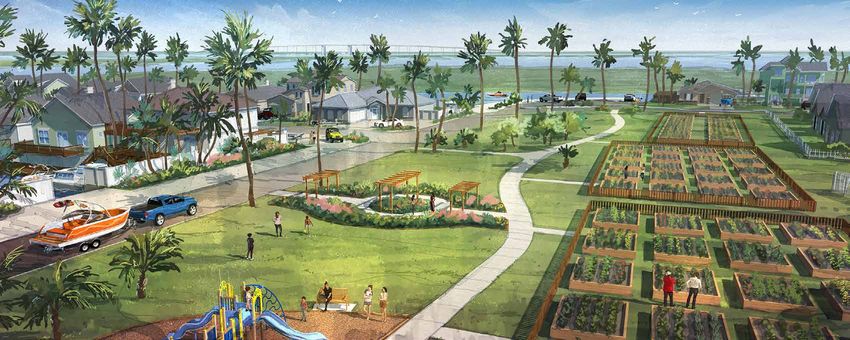
THIS PAGE INTENTIONALLY LEFT BLANK
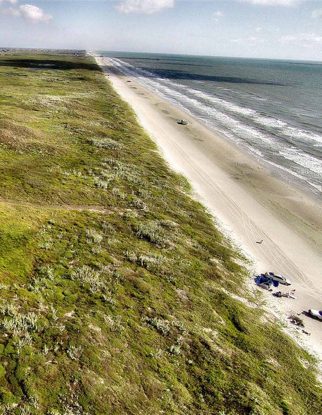
Photo Credit: Debbie Noble
P A D R E / M U S T A N G I S L A N D A R E A D E V E L O P M E N T P L A N [ D R A F T ]
F e b ruar y 2 2 , 2 0 2 1 i
Advisory Committee Review Draft Advisory Committee Review Draft
     ACKNOWLEDGMENTS
     CITY COUNCIL                                         PLANNING COMMISSION           ADVISORY COMMITTEE
     Paulette M. Guajardo                                 Jeremy Baugh
     Mayor                                                Chair                         ISLAND STRATEGIC ACTION COMMITTEE                      EX-OFFICIO / NON-VOTING MEMBERS
     Michael T. Hunter                                    Daniel Dibble                 Armon Alex                                             Bryan Gulley
     Council Member At-Large                              Vice Chair                    Mustang Island Representative                          Nueces County
     John Martinez                                        Cynthia Garza                 Polly Balzer                                           Dan McGinn
     Council Member At-Large                              Commission Member             Padre Isles Property Owners Association                Planning Commission
     Mike Pusley                                          Javier Gonzalez               Daniel Brown III                                       Keith McMullan
     Council Member At-Large                              Commission Member             At-Large                                               Nueces County Water Control and Prevention
     Billy A. Lerma                                       Brian Mandel                  Charles Duffley                                        District #4
     Council Member District 1                            Commission Member             Developer                                              Brett Oetting
     Ben Molina                                           Michael Miller                Jay Gardner, Chair                                     Convention and Visitors Bureau
     Council Member District 2                            Commission Member             Professional Engineer                                  Terry Palmer
     Roland Barrera                                       Benjamin Polak (Ex-officio)   Brud Jones, Vice Chair                                 Watershore and Beach Advisory Committee
     Council Member District 3                            Navy Representative           Residential Property Owner                             Twila Stevens
     Greg Smith                                           Sheldon Schroeder             Tommy Kurtz                                            Parks and Recreation Advisory Committee
     Council Member District 4                            Commission Member             At-Large
     Gil Hernandez                                        Michael York                  David Perry
     Council Member District 5                            Commission Member             Environmental Group                                    PLANNING COMMISSION LIASION
                                                          Kamran Zarghouni              Cheri Sperling                                         Daniel Dibble
                                                          Commission Member             Padre Island Business Association                      Planning Commission Liaison
                                                                                        Jodi Steen
                                                                                        Construction Contractor
                                                                                        Carter Tate
                                                                                        Realtor
                                                                                                                                               CONSULTANT TEAM

                                                                                                                                               Freese and Nichols, Inc.
                                                                                                                                               11200 Broadway Street, Offices West
                                                                                                                                               Suite 2320
                                                                                                                                               Pearland, TX 77584

               C I T Y O F C O R P U S C H R I S T I [ D R A F T ]                            P A D R E / M U S T A N G I S L A N D A R E A D E V E L O P M E N T P L A N [ D R A F T ]
ii             F e b ruar y 2 2 , 2 0 2 1                                                                                                                 F e b ruar y 2 2 , 2 0 2 1          iii
                                  Advisory Committee Review Draft                                                     Advisory Committee Review Draft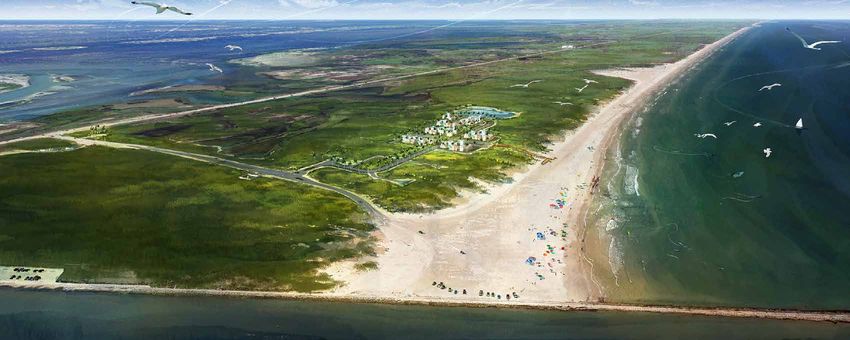
                    HOLD FOR ORDINANCE                                         HOLD FOR ORDINANCE

         C I T Y O F C O R P U S C H R I S T I [ D R A F T ]   P A D R E / M U S T A N G I S L A N D A R E A D E V E L O P M E N T P L A N [ D R A F T ]
iv       F e b ruar y 2 2 , 2 0 2 1                                                                                        F e b ruar y 2 2 , 2 0 2 1          v
                            Advisory Committee Review Draft                            Advisory Committee Review Draft
                    HOLD FOR ORDINANCE                                         HOLD FOR ORDINANCE

         C I T Y O F C O R P U S C H R I S T I [ D R A F T ]   P A D R E / M U S T A N G I S L A N D A R E A D E V E L O P M E N T P L A N [ D R A F T ]
vi       F e b ruar y 2 2 , 2 0 2 1                                                                                        F e b ruar y 2 2 , 2 0 2 1          vii
                            Advisory Committee Review Draft                            Advisory Committee Review Draft
                                                                 TABLE OF CONTENTS
                                                                 2                                                                    INTRODUCTION

                                                                 10                                               FUTURE LAND USE MAP

                                                                 16                                                                  VISION THEMES

                                                                                                                POLICY INITIATIVES AND
                                                                 24
                                                                                                                      IMPLEMENTATION

                                                                 40                        PUBLIC INVESTMENT INITIATIVES

           C I T Y O F C O R P U S C H R I S T I [ D R A F T ]        P A D R E / M U S T A N G I S L A N D A R E A D E V E L O P M E N T P L A N [ D R A F T ]
viii       F e b ruar y 2 2 , 2 0 2 1                                                                                             F e b ruar y 2 2 , 2 0 2 1          1
                              Advisory Committee Review Draft                                 Advisory Committee Review Draft
I ntrod u ction

                                    DEVELOPMENT OF THE PLAN
                                    The Padre/Mustang Island Area Development              The ADP was developed through a
                                    Plan (ADP) is an element of the Plan CC                comprehensive public engagement process
                                    Comprehensive Plan. The ADP is intended                that integrated the examination of the
                                    to provide an analysis of Padre/Mustang                existing conditions and the vision of the

INTRODUCTION                        Island and create strategic recommendations
                                    to guide future development. As the
                                    community grows, the City should have plans
                                                                                           community. An Advisory Committee was
                                                                                           created to guide the planning process
                                                                                           and provide a representation of the area’s
                                    in place to guide the anticipated growth. By           residents, business owners, and stakeholders.
                                    understanding development patterns and                 The Advisory Committee consists of the
                                    the impact it has on the community, the City           Island Strategic Action Committee (ISAC) Ex-
                                    will be better prepared for the future. This           Officio members and a Planning Commission
                                    plan serves as a guide for City leadership to          liaison. The Committee’s participation was
                                    make regulatory and policy decisions as well           essential to the development of the final
                                    as prioritize infrastructure improvements to           plan. Although the Advisory Committee
                                    increase the quality of life.                          championed the plan, the community
                                                                                           was involved throughout the process and
                                    The Padre/Mustang Island area of Corpus                participated in multiple engagement events
                                    Christi incorporates the land area of both             and activities. Residents and stakeholders
                                    Padre and Mustang Islands within the                   gave their input regarding the future of
                                    Corpus Christi city limits. Padre/Mustang              Padre/Mustang Island through online surveys
                                    Island includes residential neighborhoods,             and various community engagement events,
                                    commercial development, and miles                      including an online community open house
                                    of beaches and natural areas. As the                   and focus group meetings. Many of the
                                    development on the Island grows in the                 recommendations identified in this plan are a
                                    future, the Island must focus on balancing             direct product of the input received, resulting
                                    future development with the environmental              in a community-driven plan.
                                    sustainability of the existing natural areas on
                                    the Island.

                                          P A D R E / M U S T A N G I S L A N D A R E A D E V E L O P M E N T P L A N [ D R A F T ]
                                                                                                      F e b ruar y 2 2 , 2 0 2 1             3
  Advisory Committee Review Draft                                 Advisory Committee Review Draft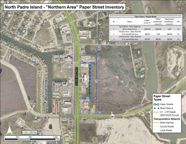
I ntrod u ction I ntrod u ction
C O M M U N I T Y D E M O G R A PH I C S
The snapshot of the current demographics of Padre/Mustang Island paints a picture of the
level of growth and diversity in the area based on Census data and estimates.
DEMOGRAPHICS H O U S I N G ( 20 1 9 ) 1
Vacant 9.3%
POPULATION 1
1 0, 1 78 1 0,783
$103,202 34.8 %
Vacant
9, 1 30 40. 4%
2 4.1% Renter-Occupied
6,300 Renter-Occupied
Median Household Income
2.48%
Padre- 0.99%
Mustang Corpus 41.2 % 50. 3%
Island Christi Owner-Occupied Owner-Occupied
$315,139
2000 2010 2019 2024*
Padre-Mustang Island Corpus Christi
Population Growth by Year Average Annual Growth Rate
*Projected Population 2000-2019 Median Home Value Occupied Housing Units
E D U C A T I O N A L A T T A I N M E N T PO PU LA T I O N 25 + ( 2 019 ) 1
RA CE AND ETHN IC ITY (20 1 9 ) 1
AGE ( 2 0 1 9 ) 1
0.1%
2.4% Native Hawaiian and
High School Graduate or GED
Asian Other Pacific Islander 3.4%
3.0% 13.0%
0-4
8.1% 3 9.1%
0.5% College Degree
Some Other Race 85+ 5 - 14
American Indian
16.7%
and Alaska Native 2.5% 21.2%
Two or More 23.5%
0.9% 65 - 84 15 - 34
Black or African
American
48.5% 2 5.9% 17. 8%
Median Age 1.5% Some College
90.6%
White
No High School Degree Graduate or Professional Degree
17.8%
Hispanic Origin 42.0%
of Any Race 35 - 64
Source: U.S. Census Bureau, Census 2010 Summary File 1. Esri forecasts for 2019 and 2024. Esri converted Census 2000 data into 2010 geography.
1
C I T Y O F C O R P U S C H R I S T I [ D R A F T ] P A D R E / M U S T A N G I S L A N D A R E A D E V E L O P M E N T P L A N [ D R A F T ]
4 F e b ruar y 2 2 , 2 0 2 1 F e b ruar y 2 2 , 2 0 2 1 5
Advisory Committee Review Draft Advisory Committee Review Draft
I ntrod u ction I ntrod u ction
A B O U T T H E A D V I S O R Y C O M M I T T EE
The Advisory Committee is comprised of the Island Strategic Action Committee (ISAC), Ex-Officio
Members, and a Planning Commission Liaison. The Committee consists of 21 Members including
ENGAGEMENT PROCESS residents, business owners, property owners, environmental stakeholders, and representatives of both
governmental and non-governmental organizations.
August 24 & 26, 2020
Advisory Committee Meeting 1 MetroQuest Survey Launched Online Community Meeting 1 Focus Group Meetings
March 12, 2020 to
March 26, 2020
March 3, 2020
May 11, 2020
The Advisory Committee met during An online survey was available to About 37 participants joined the A series of five focus group meetings
the regular ISAC meeting to identify the public, allowing for input to live presentation for the first Online were held to discuss specific topics
issues and opportunities for the Island. be received regarding the current Community Meeting to learn about the related to the Island. The purpose of
conditions and vision for the Island. Area Development Plan process and give the meetings was to discuss topics
input related to the Island’s future growth. that are significant to the future
development of the Island.
Padre/Mustang Island
Draft Vision Themes AREA DEVELOPMENT PLAN
Advisory Committee Meeting 3 Online Open House 1 Online Community Meeting 2 Advisory Committee Meeting 2
September 1, 2020
October 1, 2020 to
December 3, 2020
October 15, 2020
October 1, 2020
The Advisory Committee met during The Online Open House was A live online presentation was given to the The Advisory Committee met during
the regular ISAC meeting to review available for the community community to provide the draft vision themes, the regular ISAC meeting to review the
draft renderings, action items, and to provide feedback on the policy initiatives, and future land use plan. The online survey summary and discuss the
projects. draft vision themes, policy meeting was broadcast on Facebook Live. A 16 draft vision themes, policy initiatives,
initiatives, and future land recording of the presentation was available on and future land use plan.
use plan. the project website following the meeting.
Advisory Committee Meeting 4 Online Community Meeting 3 Online Open House 2 Advisory Committee Meeting 5
Adoption
March 2, 2021
TBD, 2021 to
The Advisory Committee A live online presentation was given to The Online Open House The Advisory Committee met to
TBD, 2021
TBD, 2021
TBD, 2021
met during the regular ISAC the community to provide the draft plan. was available for the recommend the draft plan move TBD
meeting to review the draft Area The meeting was broadcast on Facebook community to provide forward to be presented to Planning
Development Plan. Live. A recording of the presentation was feedback on the draft plan. Commission and City Council.
available following the meeting.
C I T Y O F C O R P U S C H R I S T I [ D R A F T ] P A D R E / M U S T A N G I S L A N D A R E A D E V E L O P M E N T P L A N [ D R A F T ]
6 F e b ruar y 2 2 , 2 0 2 1 F e b ruar y 2 2 , 2 0 2 1 7
Advisory Committee Review Draft Advisory Committee Review Draft
I ntrod u ction I ntrod u ction
O N L I N E S U R V EY S U M M A R Y WHA T WOULD YOU CONSIDER THE
GR EA TEST ENVIR ONM ENTA L ISSUE
WHA T WOU LD Y OU C ON S IDE R THE
GR EA TEST S OCIAL IS S UE F AC IN G
FA CING P A DR E-M USTA NG ISLA ND? P A DR E-M U S TAN G IS LAN D TODAY ?
A BOUT THE SURVEY
Community members had an opportunity to participate in an
online survey available from March 12, 2020 to May 11, 2020 to
give their feedback on the future of Padre/Mustang Island. Below
is a snapshot of the results.
518
Total Respondents
41%
51%
Hurricanes and Major
WHAT IS IMP ORTANT TO Y O U ? WHAT IS YOUR FAVORITE THI NG Storms
ABOUT PADRE-MUSTANG ISLAND?
Crime or Perception of
Crime
WHA T WOULD YOU CONSIDER THE WHA T WOU LD Y OU C ON S IDE R THE
80% THR EE GR EA TEST INFR A STR UCTUR E
ISSUE S FA CING P A DR E-M USTA NG
THR EE GR E ATE S T LAN D U S E IS S UES
FA CING P A DR E - M U S TAN G IS LAN D
ISLA ND TODA Y? TODA Y?
Access to Bus Service Other
Nature, open space and 2% 1% 26% Lack of variety in shopping, dining, and
entertainment choices
beach areas Failing Septic Poor Street/
System Pavement 23% Not enough or inadequate parks and
Sewer Conditions recreation facilities
4%
WHAT IS YOUR VISION FO R THE ISL AN D? Infrastructure
18% Not enough or inadequate natural
9% 25% recreation opportunities
“Keeping the island clean, peaceful, and
“Better entertainment, restaurants and 14% Competition with other areas of the
prosperous. Encourage small businesses Water Coastal Bend
shopping without taking away from the to provide much needed goods and Infrastructure 10%
Island Coastal community “ services.” 10% Not enough job opportunities
“50/50 split between primary residences and destination recreation.” 10% 16% 5%
Storm Water Not enough housing options
“A safe, family friendly place with open Infrastructure
“Beautiful and safe beaches and views” Inability to
beaches and parks where kids can play.“ 10% walk or ride 4% Other
13% a bike to
“A balance between a sustainable Traffic and
“A destination for vacationers and Congestion places
environment, inviting tourism spot and
locals alike with quality amenities.” Lack of golf cart/Off-highway
community engagement.“
vehicle/Neighborhood
electric vehicle paths
C I T Y O F C O R P U S C H R I S T I [ D R A F T ] P A D R E / M U S T A N G I S L A N D A R E A D E V E L O P M E N T P L A N [ D R A F T ]
8 F e b ruar y 2 2 , 2 0 2 1 F e b ruar y 2 2 , 2 0 2 1 9
Advisory Committee Review Draft Advisory Committee Review DraftF u t u r e L and u se M ap
Gulf of
Mexico
Aquarius St
Inset Gulf
Par
of
kR
Mexico
d2
2
F U T U R E LlvAd N D U S E M A P
wy 361
B
e cap
hit
A B O UW
T T H E FU T U R E LA N D U S E M A P
eH
FUTURE LAND
The Future Land Use Map serves as a guide for zoning regulations and influences new
t at development and redevelopment within the City. The Future Land Use Map for the City
S was adopted with Plan CC and has been revised through the ADP based on feedback from
the community.
S P d Dr
USE MAP
Isla
Aquarius
adr
n
The use of land is a critical ingredient in about land uses and development patterns
determining the way people live and work. specific to the Padre/Mustang Island planning
St
e Pa
There are two factors to consider when area. The future land use designations for
designating land use, how land is currently Padre/Mustang Island have been revised
lv d
p B being used and potentially could be used to reflect community input, anticipated
ca in the future. In many cases, the existing development, and best practices.
rk R
h it e active land use on the property remains
W unchanged. For undeveloped property, there Se a The
PinMap
Padre/Mustang Island Future Land
e
d 22
are opportunities to shape the way land can Use
s
zoning andD
serves as the guide for future
r
development decisions and
be developed in the future. In both cases,
provides a foundation to support the
S ea the most direct tool cities have to guide
the development of land is through zoning. vision and recommendations of the plan.
Pi ne s Dr
Zoning is the prescribed legal use of a parcel This is accomplished by setting a land
of land based on city regulations. Zoning is, use framework that influences regulatory
in large part, influenced by the designations mechanisms and policy decisions that
identified on the Future Land Use Map. shape the built environment. Each of the
designations presented on the Padre/
1
The Plan CC Comprehensive Plan (adopted
2016) identified future land uses for the
Mustang Island Future Land Use Map
correlates with the designations identified in
E
Miles
entire City and provided guidelines for Plan CC.
development. The Area Development Plan
process is intended to go into further detail
Source Freese and Nichols
Draft Date: Nov 30, 2020
P A D R E / M U S T A N G I S L A N D A R E A D E V E L O P M E N T P L A N [ D R A F T ]
F e b ruar y 2 2 , 2 0 2 1 11
Advisory Committee Review Draft Advisory Committee Review DraftFu tu re L and use M ap F u t u r e L and u se M ap
FUTURE LAND USE CATEGORIES
AGRICULTURE/RURAL COMMERCIAL USES MIXED-USE AREAS PLANNED DEVELOPMENT
ENTERPRISE Commercial land uses include retail, services,
hotel, and office uses that are typically
Mixed-use centers include residential, retail,
hotel, and office uses. Mixed-use centers are
Planned development areas are lands that
are currently undeveloped or underutilized
This category includes farms and other open to the public at large. High-density pedestrian-friendly with buildings oriented but may be suitable in the future for a variety
enterprises that serve the rural population. residential uses, such as townhomes, cottage towards the street. Residential uses are of uses, taking into account environmental
housing, apartments, and condominiums are generally of a higher density, including and other constraints. Designated on Padre
considered compatible with commercial uses. apartments, condominiums, townhomes, and Mustang islands and in the potential
Other commercial uses, such as wholesale cottage housing, and small-lot single-family annexation areas, planned development
and distribution businesses, are included residential. The mixture can be vertical, areas are expected to require a rezoning
RESIDENTIAL USES in the light industry category because
they have similar impacts, such as high
with different uses on different floors of a
building, and horizontal, with different uses
tied to a master planning process or an Area
Development Plan process.
The predominant residential land use in the volumes of trucking. Schools, churches, and side by side. Churches, schools and public
City of Corpus Christi is the single-family neighborhood-serving public uses can be uses are included in mixed-use areas.
dwelling at a range of densities. All residential included in commercial land use areas.
categories also include schools, churches, and
neighborhood-serving public uses. PERMANENT OPEN SPACE
• Low-density residential: up to 3 units per
INSTITUTIONAL Parks and playgrounds, recreational fields
acre
INDUSTRIAL USES Hospitals, colleges, universities, schools,
and facilities, greenways, and other green
areas managed for public access and
• Medium-density residential: 4 to 13 units
Most of the industrial uses within the city large churches, and similar institutions, recreation.
per acre (including two-family dwellings)
limits of Corpus Christi are light industrial; whether public or private, are designated
• High-density residential: more than 13 heavy industry is generally located in the as separate land uses because of their
units per acre industrial districts outside the city limits. campus-like character, which requires special
attention to edges and relationships with
adjacent areas. FLOOD PLAIN
TRANSPORTATION CONSERVATION
Lands within the 100-year flood plain,
Airports, railroads, highway and interstate
rights-of-way.
GOVERNMENT preferably preserved for environmental
reasons.
Government uses include federal, state,
county, regional and municipal government
facilities and installations, except for Note: For more information about categories
government-owned institutions. included in the Future Land Use Map, please
refer to pages 55-57 of Plan CC.
C I T Y O F C O R P U S C H R I S T I [ D R A F T ] P A D R E / M U S T A N G I S L A N D A R E A D E V E L O P M E N T P L A N [ D R A F T ]
12 F e b ruar y 2 2 , 2 0 2 1 F e b ruar y 2 2 , 2 0 2 1 13
Advisory Committee Review Draft Advisory Committee Review DraftFu tu re L and use M ap F u t u r e L and u se M ap
F U T U R E L A N D U S E MDraft
AP
61
State Hwy 3
Future Land Use Corpus
Christi
Corpus
Christi
Bay Bay
Mixed-Use
LAND USE ACRES %
Commercial
Government
Mixed-Use 449 2%
Light Industrial
Low-Density Residential
Commercial 404 2%
Medium-Density Residential
Government 62 0% High-Density Residential
Planned Development
Light Industrial 1 0% Transportation
Permanent Open Space
Low-Density Flood Plain Conservation
15 0%
Residential Water
Medium-Density Padre/Mustang Island
1,405 6% Gulf of
Residential Corpus Christi City Limits Mexico
High-Density
270 1%
Residential
Aquarius St
Planned Inset Gulf
2,691 12%
Par
Development of
kR
Mexico
d2
Transportation 784 4%
2
Permanent Open
6,948 32% d
wy 361
Space Blv
cap
Flood Plain W hite
201 1%
eH
Conservation
at
St
Water 8,514 39%
S P d Dr
Isla
Aquarius
adr
n
St
e Pa
Total 21,744 100% d
Blv
ap
itec
rk R
Wh Se a Pi
n es D r
d 22
S ea
Pi ne s Dr
1
E
Miles
Source Freese and Nichols
Draft Date: Nov 30, 2020
C I T Y O F C O R P U S C H R I S T I [ D R A F T ] P A D R E / M U S T A N G I S L A N D A R E A D E V E L O P M E N T P L A N [ D R A F T ]
14 F e b ruar y 2 2 , 2 0 2 1 F e b ruar y 2 2 , 2 0 2 1 15
Advisory Committee Review Draft Advisory Committee Review DraftV ision The me s
VISION THEMES
Although development is generally impacted • Environmental Preservation
by a variety of regulatory factors, market
influences, and budgetary availability; a » Capitalize on existing environmental
community with a clear vision can better features as amenities for the community
focus the goals for the future. The vision and ensure the preservation of these
VISION THEMES
for the community should be a high level areas as the Island continues to develop.
overarching idea of the future that maintains
a singular path for the future. To achieve that M Y V I S I O N IS . . .
vision, the City must make an effort to direct
development and make improvements that
align with the vision.
Through the public engagement process,
three vision themes emerged related to
the residents’ desires for the future. The
following are the vision themes identified:
• Safe, Family-Friendly Community
» Continue to foster safe, family-friendly
neighborhoods that provide needed
amenities and services for local
residents.
• Blended Residential Community and
Destination Location
» Encourage tourism and the development
of local commercial businesses to build
a strong economic environment and
sufficiently support the year-round
residential community.
P A D R E / M U S T A N G I S L A N D A R E A D E V E L O P M E N T P L A N [ D R A F T ]
F e b ruar y 2 2 , 2 0 2 1 17
Advisory Committee Review Draft Advisory Committee Review DraftV ision Themes V ision The me s
SAFE, FAMILY-FRIENDLY COMMUNITY K EY E LE M E N T S C O M M U N I T Y I NPUT
Continue to foster safe, family-friendly neighborhoods that provide needed amenities and • Family-Friendly Neighborhood The following community input supports the
services for local residents. vision theme:
• Well-Maintained Park Facilities
VIS IO N “A great place to live and raise my kids while
• Walkable/Bikeable Streets still being an attraction for recreation and
The Island is a coastal community that features family-friendly neighborhoods and a strong • Park Amenities like Community Gardens entertainment.”
sense of community. With safe neighborhoods and quality amenities, the Island continues to be and Playground
a wonderful place to live, work, and raise a family. Close access to the beach and water activities “A family friendly community where people
is only one of the many reasons that people call the Island home. In the future, the local parks • Access to Water Activities can enjoy living and feel safe.”
are maintained and include a variety of amenities like walking trails, community gardens, and “More things to do, such as shops, places to
recreational equipment for all ages. A well-connected system of safe, walkable streets and trails • Golf Cart Paths
run, family activities.”
encourages walking, cycling, and the use of neighborhood electric vehicles, and allows residents
to traverse the Island from beach-to-bay. As the Island evolves, the future vision is to continue “Encourage small businesses to provide
to maintain the existing sense of community that already permeates throughout the Island. much needed goods and services.”
C I T Y O F C O R P U S C H R I S T I [ D R A F T ] P A D R E / M U S T A N G I S L A N D A R E A D E V E L O P M E N T P L A N [ D R A F T ]
18 F e b ruar y 2 2 , 2 0 2 1 F e b ruar y 2 2 , 2 0 2 1 19
Advisory Committee Review Draft Advisory Committee Review DraftV ision Themes V ision The me s
BLENDED RESIDENTIAL COMMUNITY AND DESTINATION LOCATION K EY E LE M E N T S C O M M U N I T Y I NPUT
Encourage tourism and the development of local commercial businesses to build a strong economic • Improved PR22 with New Bridge and Golf The following community input supports the
environment and sufficiently support the year-round residential community. Cart Path vision theme:
VIS ION • Commercial/Mixed-Use Development “Good restaurants, resort atmosphere,
geared to both tourists and residents.”
The Island aims to be a premier destination location that seamlessly blends a coastal residential • Town Center Style Development
community with a lively tourism center. Commercial and mixed-use development is encouraged “To see our community as a great place to
• Marina Development live and a great place to visit.”
along PR22 to provide needed services and create entertainment opportunities to attract
residents and visitors to the Island. Creating a town-center style development will serve as the • Tourist Activities “More developed with hopefully shops and
community center and focus of entertainment activities on the Island. Improvements in tourism restaurants along the Canal and lake padre
infrastructure such as hotel facilities, creation of a marina, and conference facilities allow the where park road 22 bridge is to be built.”
Island to better accommodate large events like festivals and tournaments. Amenities encourage
visitors to extend their stay on the Island without having to use their personal vehicles during
their visit. Additionally, using various wayfinding and branding elements throughout the Island
could promote its identity.
C I T Y O F C O R P U S C H R I S T I [ D R A F T ] P A D R E / M U S T A N G I S L A N D A R E A D E V E L O P M E N T P L A N [ D R A F T ]
20 F e b ruar y 2 2 , 2 0 2 1 F e b ruar y 2 2 , 2 0 2 1 21
Advisory Committee Review Draft Advisory Committee Review DraftV ision Themes V ision The me s
ENVIRONMENTAL PRESERVATION K EY E LE M E N T S C O M M U N I T Y I NPUT
Capitalize on existing environmental features as assets for the community and ensure the • Healthy Dunes The following community input supports the
preservation of these areas as the Island continues to develop. vision theme:
• Beach Activity
VIS ION • Vehicle Access to the Beach
“A balance between a sustainable
environment, inviting tourism spot and
Padre and Mustang Islands feature miles of beaches and wetlands stretching across both • Conservation Corridors community engagement.”
islands that serve as unique assets for residents and visitors. As the development of the Island
progresses, it is essential to balance the preservation of natural areas with a sustainable level • Limited Development “Preserve natural beauty, avoid
of growth. There should be a focus on protecting the beaches to support the dune system and overdevelopment.”
protect the Island community and, ultimately, the mainland. Creating conservation corridors “Better entertainment, restaurants and
and mitigating barriers between critical habitat areas will benefit local wildlife and overall shopping without taking away from the Island
environmental stability. Implementing educational and monitoring programs will support the Coastal community.”
on-going maintenance and enhancement of preservation and conservation areas on the Island.
C I T Y O F C O R P U S C H R I S T I [ D R A F T ] P A D R E / M U S T A N G I S L A N D A R E A D E V E L O P M E N T P L A N [ D R A F T ]
22 F e b ruar y 2 2 , 2 0 2 1 F e b ruar y 2 2 , 2 0 2 1 23
Advisory Committee Review Draft Advisory Committee Review DraftP olic y I nitiativ e s and I mpl e m e ntation
POLICY INITIATIVES
Six policy initiatives were established to focus on implementation efforts to achieve the visions
themes described in this plan. Policy initiatives are not exclusive and may further the goal of
one or more vision themes. For each policy initiative, strategies are identified to support the
implementation of the efforts. These strategies are the actions taken by the City that lead to
the successful implementation of the plan.
POLICY POLICY INITIATIVES SAFE, FAMILY-
VISION THEMES
BLENDED
RESIDENTIAL
ENVIRONMENTAL
INITIATIVES AND
FRIENDLY COMMUNITY AND
PRESERVATION
COMMUNITY DESTINATION
LOCATION
Improve traffic flow, Island
IMPLEMENTATION 1 ingress and egress, safety, and
roadway quality.
Enhance park and recreation
facilities to provide various
2 activities and entertainment for
all ages.
Expand tourism on the Island by
increasing marketing efforts and
3 providing a variety of events and
attractions.
Protect and monitor natural
resources and assets critical to
4 the health of the barrier island
and regional ecosystem.
Accommodate safe, efficient
movement of pedestrians, bikes,
5 and golf carts throughout the
Island.
Support and encourage
compatible and context-sensitive
6 development that provides a mix
of land uses and respects the
environment.
P A D R E / M U S T A N G I S L A N D A R E A D E V E L O P M E N T P L A N [ D R A F T ]
F e b ruar y 2 2 , 2 0 2 1 25
Advisory Committee Review Draft Advisory Committee Review DraftP olic y I nitiativ e s and I mpl e m e ntation P olic y I nitiativ e s and I mpl e m e ntation
1
1.7. Ensure priority residential streets are 1.8. Collaborate with property owners to
IMPROVE TRAFFIC FLOW, ISLAND INGRESS incorporated in the City’s Infrastructure
Management Plan.
explore funding opportunities and
evaluate options to construct paper
streets on the Island.
AND EGRESS, SAFETY, AND ROADWAY 1.7.1. Monitor roadway speed limits
on major corridors and consider 1.9. Coordinate with the Corpus Christi
QUALITY methods and improvements
to reduce vehicular speeds if
Regional Transportation Authority
(CCRTA) or private commercial
necessary, such as installing providers to develop flexible mobility
street trees and landscaping, services to meet diverse travel needs
incorporating roundabouts, that serve points of interest on the
H OW WE G ET THERE speed humps, medians, or pinch Island for residents and visitors.
points, and the introduction of
1.1. Coordinate with the Corpus Christi 1.4. Work with the MPO and TxDOT to safe pedestrian facilities along
Metropolitan Planning Organization develop a solution for traffic congestion the roadway.
(MPO) to update the Urban at the PR22 and SH361 intersection.
Transportation Plan based on traffic
1.5. Continue to work with private
demand modeling.
landowners, TxDOT and the Texas
1.1.1. Delete the proposed collector General Land Office to identify
street located on the west potential beach accesses and get
side of SH 361, located within them constructed (i.e. Access 2B) and
Mustang Island State Park and continue to maintain these access roads
between Beach Access Road 2 for the benefit of the public.
and Seaway Drive Extension,
1.6. Rename beach access roads to
from the Urban Transportation
correspond with their adjacent mile
Plan.
marker to facilitate emergency
1.2. In coordination with Federal, State, response.
Regional, and County agencies,
prioritize a long-term action plan for
maintaining sufficient emergency egress
from the Padre and Mustang Islands,
which may include a second crossing
of the Laguna Madre, expanding the
current JFK Causeway Bridge, and/
or replacing the JFK Causeway Bridge
(constructed in 1973).
1.3. For public safety and to protect roadway
capacity on SPID/PR22 and SH361, work
with TxDOT on access management
controls for future development, i.e.,
shared driveways, interconnected
parking, etc.
Example of Access Management Controls Northern Area Paper Street Inventory
C I T Y O F C O R P U S C H R I S T I [ D R A F T ] P A D R E / M U S T A N G I S L A N D A R E A D E V E L O P M E N T P L A N [ D R A F T ]
26 F e b ruar y 2 2 , 2 0 2 1 F e b ruar y 2 2 , 2 0 2 1 27
Advisory Committee Review Draft Advisory Committee Review DraftP olic y I nitiativ e s and I mpl e m e ntation P olic y I nitiativ e s and I mpl e m e ntation
2
1.9.1. Investigate options for
adding water transportation,
microtransit, on-demand, and ENHANCE PARK AND RECREATION
other modes of connecting
destinations on the Island. FACILITIES TO PROVIDE VARIOUS ACTIVITIES
AND ENTERTAINMENT FOR ALL AGES
1.10. Conduct a transportation study to
identify walking, cycling, and golf cart
pathways that connect residential
neighborhoods to commercial and retail
uses, as well as the east and west sides
of the Island. HOW WE GET THERE
1.11. Develop a program to install street
lighting on Padre Island where current 2.1. Prioritize full development of existing
conditions are not meeting the City parks on the Island. These parks include
lighting standards for the distance Jackfish, Aquarius, Commodores, Billish,
between light poles. Ensure lighting and Douden Parks. The improved parks
standards reduce light pollution to will be regularly maintained according
maintain dark skies to protect sea to the City’s Parks Master Plan.
turtles and birds. Example of Signage Along Golf Cart Path 2.1.1. Identify appropriate locations
to incorporate or add new park
amenities, including walking
trails, community gardens,
volleyball courts, pickleball
courts, tennis courts, splash
pads.
2.1.2. Encourage community
Sandy and Don Billish Park
participation and partnerships
to implement the
recommendations of the Parks
Master Plan Update (underway
at time of print).
Example of Bicycle and Pedestrian Improvements with On-Street Parking, Protected Multiuse Path, and Pedestrian Crosswalk 2.2. Improve and maintain the Packery
Channel recreational facilities such
as roadway access, parking, pavilions,
concessions, bathhouses, restrooms,
public fishing facilities, beach
maintenance, observation areas, nature
trails, and street lighting.
Packery Channel Recreational Facilities
C I T Y O F C O R P U S C H R I S T I [ D R A F T ] P A D R E / M U S T A N G I S L A N D A R E A D E V E L O P M E N T P L A N [ D R A F T ]
28 F e b ruar y 2 2 , 2 0 2 1 F e b ruar y 2 2 , 2 0 2 1 29
Advisory Committee Review Draft Advisory Committee Review DraftP olic y I nitiativ e s and I mpl e m e ntation P olic y I nitiativ e s and I mpl e m e ntation
3
2.3. Analyze and pursue alternative means
of creating special funds for capital
2.4. Pursue additional public boat ramps and
parking for access to the Laguna Madre EXPAND TOURISM ON THE ISLAND BY
INCREASING MARKETING EFFORTS AND
improvements, public facilities, and and Corpus Christi Bay. Joint public
beach operations/maintenance. These agreements between the County, the
funding mechanisms may include bond State, or other entities could facilitate
program funding, hotel/motel tax, beach
parking fees, grants, and other local,
this objective and reduce overall costs. PROVIDING A VARIETY OF EVENTS AND
ATTRACTIONS
2.5. Explore the development of a public,
State, or Federal programs. private, or joint multi-purpose meeting
2.3.1. Conduct on-going coordination facility as a place for senior citizen
with Nueces County and other activities, voting facility, resident public
organizations that focus on functions, and other public/recreational HOW WE GET THERE
environmental improvements functions. If land on existing City parks
and sustainability to provide is not suitable, the City should consider 3.1. Signage requirements should promote
consistency and efficiency in a joint agreement with the County on a coordinated and cohesive design and
beach maintenance efforts. County park land in the area. reinforce a desirable identity of the
2.3.2. Conduct a beach parking 2.6. Encourage the development of an ocean Island.
fee study to determine how safety and educational training center, 3.1.1. Develop and implement a
current parking fees compare nature center, canoe/kayak clubs, surf consistent branding strategy
to industry standards and if clubs to promote water recreation and for the Island in coordination
they sufficiently fund beach water safety programming. with the overall Visit Corpus
maintenance needs and safety 2.7. Investigate opportunities to utilize Christi wayfinding master plan
operations. effluent from the Whitecap Wastewater currently in development.
2.3.3. Work with partner agencies to Treatment Plant to irrigate landscaping 3.1.2. Develop sign code requirements
evaluate extension of the TIRZ. at parks, public rights-of-way, and other that promote the identity of the
municipal facilities where feasible. Island.
2.8. Investigate opportunities for providing 3.2. Promote tourist-oriented development
public library services on the Island such east of State Highway 361/Park Road 22
as via a vending machine, a bookmobile and between Zahn Road and Whitecap
library, or by placing satellite book Boulevard by providing public and
Example of Signage with Consistent Character Meeting Design
collections within publicly accessible private amenities to make the area more Requirements Such as Colors and Sign Type
buildings. Programming services, such attractive and “people-friendly”. These
as storytime, could be provided at a amenities should support a multimodal
publicly accessible building via a roving transportation system (pedestrian,
Librarian. bicycle, vehicular, golf cart, and
water transit) and uniquely attractive
developments, both public and private,
with facilities using the highest quality
design and materials.
Padre Balli Park Beach Maintenance
Photo Credit: Debbie Noble Example of Directional Signage with City Branding
C I T Y O F C O R P U S C H R I S T I [ D R A F T ] P A D R E / M U S T A N G I S L A N D A R E A D E V E L O P M E N T P L A N [ D R A F T ]
30 F e b ruar y 2 2 , 2 0 2 1 F e b ruar y 2 2 , 2 0 2 1 31
Advisory Committee Review Draft Advisory Committee Review DraftP olic y I nitiativ e s and I mpl e m e ntation P olic y I nitiativ e s and I mpl e m e ntation
4
PROTECT AND MONITOR NATURAL
3.3. Private land located south of the 3.7. Partner with Visit Corpus Christi for
Packery Channel and landward of the a focused campaign to promote the
RESOURCES AND ASSETS CRITICAL TO
seawall should be developed with a Island.
mix of high-density tourist-oriented 3.7.1. Specify tourism opportunities
commercial and residential activities.
Development standards for this area
for eco-tourism, fishing, birding,
water sports, and family-friendly THE HEALTH OF THE BARRIER ISLAND AND
will be of a very high order requiring
abundant landscaping, a consistent
urban design theme, and public
activities through marketing
efforts. REGIONAL ECOSYSTEM
improvements that exceed standard 3.7.2. Coordinate with Visit Corpus
requirements. Christi to implement initiatives
identified in the 2021-2023
HOW WE GET THERE
3.4. Encourage the development of a full- Strategic Plan.
service marina in Lake Padre opening 4.1. The design and use of naturally 4.2. Encourage the protection of sensitive
up Padre Island to recreational sailing 3.7.3. Conduct a feasibility study for regenerating systems for prevention wildlife habitats and the Islands’
and power vessels with unfettered a conference and events center and control of beach dune erosion environment by considering innovative
access to the Gulf. and hotel on the Island. are encouraged and preferred over design techniques, implementation of
3.5. Encourage festival sites on the Island 3.8. Facilitate town center style development bulkheads and other hard structures incentives for developers, and allowing
for special events. Facility improvements around Lake Padre to serve as a central provided the protection system is a higher than typical development
are intended to make the Corpus gathering space for residents and reasonable solution to the site where density in uplands where practical. It
Christi Gulf Coast a premier location for visitors. it is proposed. Regenerating systems is not the intent of this plan to initiate
hosting special beach events. Festival include, but are not limited to: requirements for protection of non-
3.8.1. Implement commercial or
site facilities and locations may be 1. Beach nourishment; jurisdictional wetlands.
mixed-use zoning around Lake
developed as joint ventures with the Padre to support retail and 2. Adaptive beach management 4.2.1. Incentivize developers to
County, State, or with private property commercial uses as well as practices; voluntarily preserve the
owners. visitor accommodations and existing natural environment by
housing. 3. Planting with short-term concentrating the total number
3.5.1. Evaluate the feasibility of mechanical assistance, when
various City or County-owned of units allowed, based on gross
3.8.2. Coordinate with property owners appropriate; and
property on the Island to serve acreage (including wetlands),
about the future development of
as a festival site. 4. Any other method consistent into a multi-story building
properties around Lake Padre.
with the recommendations or buildings. This “cluster
3.6. Provide destination, recreation, and of the Texas General Land development” results in large
entertainment options and activities Office’s Dune Protection and setbacks, buffer zones, reduced
that encourage visitors to lengthen their Improvement Manual for the infrastructure costs, and more
stay on Padre/Mustang Island. Texas Gulf Coast. permanent open space.
C I T Y O F C O R P U S C H R I S T I [ D R A F T ] P A D R E / M U S T A N G I S L A N D A R E A D E V E L O P M E N T P L A N [ D R A F T ]
32 F e b ruar y 2 2 , 2 0 2 1 F e b ruar y 2 2 , 2 0 2 1 33
Advisory Committee Review Draft Advisory Committee Review DraftP olic y I nitiativ e s and I mpl e m e ntation P olic y I nitiativ e s and I mpl e m e ntation
4.3. Develop a revision to the landscape feasibility of connecting critical
requirements in the City’s Unified habitats across SH361 and PR22,
Development Code to create an such as large culvert tunnels
indigenous species and wetlands and land bridges.
allowance for landscaping on the 4.14. Work with the Texas General Land Office
barrier islands. New development and local environmental and community
may incorporate natural wetlands and organizations to implement restoration
vegetation to partially satisfy landscape projects on Padre and Mustang Islands.
requirements where such features
can meet the screening performance 4.15. Discourage invasive and nuisance
criteria. animal and plant species and encourage
the use of native coastal plant species
4.4. Complete construction of the Park Road on the Island through education
22 bridge and canal connecting Lake programs and by updating city Example of Bioswale
Padre/Packery Channel with the existing ordinances.
Padre Isles Subdivision to improve canal Example of Effluent Water Used for Landscaping
system water quality in Padre Isles; 4.15.1. Provide a program to educate
improve surface drainage along SPID the public about the dangers of
resources and assess effectiveness of
by providing outfalls for storm drainage invasive species to the sensitive
policies and programs in place.
along the roadway; and provide a ecosystem on the Island, such as
4.10. Participate in development and updates the Brazilian Pepper Tree.
convenient water transportation system
of other agencies’ documents, such as
for small watercraft between the 4.15.2. Partner with and expand the
the Texas General Land Office’s Texas
Padre Isles residential area and future Texas Gulf Coast Cooperative
Coastal Resiliency Master Plan.
commercial development in Lake Padre/ Weed Management Area
Packery Channel. 4.11. Implement dune construction and repair program south, beyond the
methods recommended by the Dune current Packery Channel project
4.5. Encourage the development of future
Protection and Improvement Manual for boundary.
expanded canal systems as part of
the Texas Gulf Coast.
future developments on North Padre 4.15.3. Develop a program to educate Example of Permeable Parking Surface
Island and Mustang Island. 4.12. Improve stormwater infrastructure residents about the benefits
to address flooding on roadways and and services the urban forest 4.15.5. Work with residents to identify
4.6. Continue on-going maintenance of
standing water. Where appropriate, provides and encourage tree appropriate locations within
the Packery Channel as it is a valuable
incorporate rainwater infiltration preservation and planting public parks and grow native
resource for material to re-nourish the
infrastructure such as bioswales and activities on public and private dune vegetation to replant on
beach.
permeable parking surfaces. lands. dunes after storms.
4.7. Continue to reuse effluent from the
4.13. Work with environmental organizations 4.15.4. Work with other public, 4.15.6. Work with other public,
Whitecap Wastewater Treatment Plant
to conserve the critical habitat for environmental, and community environmental, and community
to benefit the Island as a source of
protected species, including Red Knots, organizations to identify and organizations to develop a
water for landscaping on the Islands.
Black Rails, and Piping Plover. prioritize preservation of strategy for balancing habitat
4.8. Coordinate with responsible agencies to remnant native groves, such
4.13.1. Develop and preserve needs and managing wildlife in
update the Joint Erosion Response Plan. as oak mottes, that provide
conservation corridors to developed and developing areas
4.9. Establish a baseline and sufficient provide freedom of movement critical habitat to resident and of the Island.
funding to support sustainable for wildlife. Explore options and migratory birds.
monitoring of the beach and dune
C I T Y O F C O R P U S C H R I S T I [ D R A F T ] P A D R E / M U S T A N G I S L A N D A R E A D E V E L O P M E N T P L A N [ D R A F T ]
34 F e b ruar y 2 2 , 2 0 2 1 F e b ruar y 2 2 , 2 0 2 1 35
Advisory Committee Review Draft Advisory Committee Review DraftP olic y I nitiativ e s and I mpl e m e ntation P olic y I nitiativ e s and I mpl e m e ntation
5 6
ACCOMMODATE SAFE, EFFICIENT SUPPORT AND ENCOURAGE COMPATIBLE
AND CONTEXT-SENSITIVE DEVELOPMENT
MOVEMENT OF PEDESTRIANS, BIKES, AND
THAT PROVIDES A MIX OF LAND USES AND
GOLF CARTS THROUGHOUT THE ISLAND RESPECTS THE ENVIRONMENT
H OW WE G ET THERE HOW WE GET THERE
5.1. Implement the pedestrian and bicycle 5.3. Make roadway and trail improvements 6.1. Place utility lines underground, where 6.2. Update building code requirements
amenities as prescribed in the MPO’s to create a community that can easily be practical, and minimize disturbance to encourage new construction to
Strategic Plan for Active Mobility Phase traveled from beach-to-bay. of wetlands, dunes, or other sensitive implement resilient building standards
1: Bicycle Mobility (adopted 2016) and 5.3.1. Improve pedestrian safety habitats and wildlife. This will improve and technologies paired with reduced
Phase II: Pedestrian Mobility (under infrastructure to facilitate crossing the aesthetics of the area and insurance burdens for property owners.
development). These plans are intended PR22 at Whitecap Blvd. and SH361. potentially improve public safety, 6.3. Review existing Planned Unit
to foster cycling and walking as safe and particularly in times of weather
5.3.2. Where feasible and appropriate, Developments (PUDs) to determine
viable transportation alternatives to emergencies.
use simple and low-cost common elements and incorporate
enhance access to essential goods and
interventions to create safe 6.1.1. The installation of new them into a new base zoning district.
services for all residents and visitors in
pedestrian and bicycle facilities, electrical, telephone, or other 6.4. Identify priority wetland habitats on
our community.
such as painting trails on existing utility lines, where practical public lands for preservation and
5.1.1. Work with property owners to pavement, adding perpendicular along expressways, arterials, restoration and develop a program
secure needed easements. concrete or rubber wheel blocks, and collector streets, or the to facilitate development mitigation
5.1.2. Coordinate with the MPO to or flexible delineator posts to substantial expansion of requirements within these prioritized
update the Mobility Plan to separate pedestrians and bicycles existing electrical, telephone, sites.
include connectivity for a range from vehicles. Identify a location or other utility lines along
these roadways should be 6.5. Develop a consistent theme and
of transportation options, such as for a demonstration project, such
pedestrians, bicycles, golf carts as the streets in the vicinity of the accomplished underground or character for Island businesses that
and other Neighborhood Electric North Padre Seawall. underwater, where practical. create a sense of place.
Vehicles (NEVs), and possibly 5.4. Coordinate with the Corpus Christi 6.1.2. Existing utility lines are to 6.5.1. Review and update the Island
autonomous delivery robots and Regional Transportation Authority (CCRTA) be relocated underground Overlay District to incorporate
other technologies in the future. to increase transit service to and from the wherever practical, as the City design standards that align
5.2. Create a sidewalk network that provides Island and enhance rider amenities. and/or State undertake street with the character of the
pedestrian connectivity among or highway projects or when Island. Recommended updates
5.5. Coordinate with the MPO and TxDOT to include adding golf cart and
residential, retail, commercial, and evaluate options for providing a pedestrian a utility company replaces
recreational uses. overhead utility lines. bicycle parking facilities, revised
and bicycle connection to Flour Bluff. architectural design, and revised
5.2.1. Provide safe pedestrian facilities 5.6. Incorporate ADA accessibility in all landscaping requirements.
along PR22. pedestrian connectivity improvements
5.2.2. Encourage private developers ensuring people of all abilities are
to incorporate a pedestrian accommodated.
boardwalk along Lake Padre.
C I T Y O F C O R P U S C H R I S T I [ D R A F T ] P A D R E / M U S T A N G I S L A N D A R E A D E V E L O P M E N T P L A N [ D R A F T ]
36 F e b ruar y 2 2 , 2 0 2 1 F e b ruar y 2 2 , 2 0 2 1 37
Advisory Committee Review Draft Advisory Committee Review DraftP olic y I nitiativ e s and I mpl e m e ntation P olic y I nitiativ e s and I mpl e m e ntation
6.6. Encourage the development of locally 6.8. Promote solid waste programs for brush
owned, boutique-style retail and and bulky items on the Island, such as
entertainment venues. the Community Cleanup Trailer, Litter
6.6.1. Work with the Corpus Christi Critter, and Super Bag programs.
Regional Economic Development 6.9. Improve water and wastewater
Center (CCREDC) to identify infrastructure to support future
opportunities that encourage development along PR22.
and incentivize small businesses 6.10. Police staffing will be increased as
development. population grows and call volume
6.7. Expand the availability of 5G and increases.
broadband fiber connections on the
Island.
Example of Development with Island Character
C I T Y O F C O R P U S C H R I S T I [ D R A F T ] P A D R E / M U S T A N G I S L A N D A R E A D E V E L O P M E N T P L A N [ D R A F T ]
38 F e b ruar y 2 2 , 2 0 2 1 F e b ruar y 2 2 , 2 0 2 1 39
Advisory Committee Review Draft Advisory Committee Review DraftP u b lic I nv e stm e nt I nitiativ e s
P UB L I C I N V E S T M E N T I N I T I A T I V E S
The built environment is the physical Short-term projects can begin soon after
interpretation of the vision for the adoption. These projects are considered “low
PUBLIC community. The following public investment
projects represent improvements that
directly support the implementation of the
hanging fruit.” They are more attainable and
do not require large amounts of funding.
These projects are generally planned CIP
INVESTMENT
vision and goals. These projects should projects in the next five years.
inform the capital improvement program
(CIP) by prioritizing projects identified here Mid-term projects are not as attainable
for future CIP planning. Some identified within the first five years. They require
INITIATIVES projects are currently planned capital
improvements by the City. Others are
proposed projects for implementation based
planning or funding to prepare but should be
implemented in six to ten years.
Long-term projects may not currently have
on feedback from the community. The public an anticipated time frame for implementation
investment projects are divided into three or may require prerequisite planning before
time frames: implementation. Long-term projects should
• Short-Term (Next 5 Years) be revisited to assess the status of the
project and determine if implementation can
• Mid-Term (6-10 Years) be accomplished sooner.
• Long-Term (More Than 10 Years)
P A D R E / M U S T A N G I S L A N D A R E A D E V E L O P M E N T P L A N [ D R A F T ]
F e b ruar y 2 2 , 2 0 2 1 41
Advisory Committee Review Draft Advisory Committee Review DraftP u b lic I nv e stm e nt I nitiativ e s P u b lic I nv e stm e nt I nitiativ e s
S7
SHORT-TERM (1-5 YEARS) DRAFT
Public Investment Corpus
Christi
Corpus
Christi
# PROJECT NAME # Initiatives
PROJECT NAME Bay Bay
PARK AND TRAIL IMPROVEMENTS S10 Sea Pines Dr. Rehabilitation
ShortSt.Term Project Types
361
P1 North Padre Island Beach Facility S11 Cruisier Rehabilitation
Health Ct. and Safety Improvements
State Hwy
P2 Douden Park Improvements S12 King Phillip Rehabilitation
Parks and Trails
Aquarius St. Rehabilitation
P3 Aquarius Park Improvements S13 Street Improvements
(Commodores Dr. to Das Marinas Dr.) S2
Billish Park Park Amenity Improvements
P4
& Covered Basketball Court Utility/Infrastructure
Aquarius St. Rehabilitation Improvements S3 U2 P5, P6, P7
S14
(TopsailPadre/Mustang
St. to WhitecapIsland
Blvd. )
Packery Channel Dredging & Beach
P5 S15 CaravelCorpus Christi City Limits
Dr. Rehabilitation
Nourishment
Packery Channel Hurricane Harvey S16 Yardarm Ct. Rehabilitation
P6
Repairs S17 Bowspirit Ct. Rehabilitation S5 U1
P7 Packery Channel Monitoring S18 Mutiny Ct. Rehabilitation
Gulf of S13 S4
P8 Dune and Beach Monitoring* S19 Beaufort Ct. Rehabilitation
Mexico S9
P9 Riley P. Dog Park (Civic Organization) S20 Blackbeard Dr. Rehabilitation P1 U5
STREET IMPROVEMENTS S21 Man O War Ct. Rehabilitation
S1
P2
Aquarius St
S1 Park Road 22 Bridge S22 Barataria Dr. Rehabilitation Inset Gulf
Par
U6 of
JFK Causeway Access Road S23 Years 3-5 IMP**
kR
S2 S12 P3 Mexico
Improvements (Bond 2018)
UTILITY/INFRASTRUCTURE IMPROVEMENTS
d2
2
S3 Jackfish Ave. Improvements
U1 Packery Channel Water Line S20
PR22 Median Improvements S14
S4 U2 Sand Dollar Pump Station d S22
wy 361
(Compass St.) Blv S11
cap
U3
Whitecap Wastewater Treatment Plant U4 W hite
S5 PR22 South Access Road Improvements S21
Improvements
eH
S6
Encantada Traffic Safety Improvement
Whitecap Wastewater Treatment Plant, S t at
Project U4
Odor Control, Bulkhead Improvements S6
S P d Dr
Isla
S7 Beach Access Road 2A (Bond 2020) S17
Aquarius
S15
adr
U5 Park Road 22 Lift Station S19
n
U3 S16
St
e Pa
Island Mobility Plan for Pedestrian, P4
U6 Aquarius Lift Station Repairs
S8 Bicycle, Golf Cart, and Other Alternative B lvd P9 S18
U7 Stormwater Master Plan Development* ap
Transportation* itec
rk R
Wh
d 22
Pedestrian and Bike Safety Improvements
S9
(North Padre Sea Wall Area) S ea
Pi ne s Dr
*Project Not Mapped S10
**The first two years of the Infrastructure Management Plan (IMP) are considered to be complete in
the planning process, while the subsequent three-years are considered to be on a rolling list that is 1
E
utilized for planning purposes. The IMP will be updated and presented to Council for adoption annually.
Residents are encouraged to visit https://www.cctexas.com/imp for the most current list of projects.
Miles
Draft date: Feb 18, 2021
C I T Y O F C O R P U S C H R I S T I [ D R A F T ] P A D R E / M U S T A N G I S L A N D A R E A D E V E L O P M E N T P L A N [ D R A F T ]
42 F e b ruar y 2 2 , 2 0 2 1 F e b ruar y 2 2 , 2 0 2 1 43
Advisory Committee Review Draft Advisory Committee Review DraftP u b lic I nv e stm e nt I nitiativ e s P u b lic I nv e stm e nt I nitiativ e s
P14
MID-TERM (5-10 YEARS) DRAFT
Public Investment Corpus
Christi
Corpus
Christi
# PROJECT NAME Initiatives Bay Bay
PARK AND TRAIL IMPROVEMENTS Mid Term Project Types
361
Seawall Repairs, Access Improvements, Health and Safety Improvements
State Hwy
P10
and Amenities (Private Ownership) Parks and Trails P15
P11 Seawall Parking Lot Pavillion Street Improvements P16
P12 Ulberg Park Improvements Utility/Infrastructure Improvements S26
P13 Commodore Park Improvements Padre/Mustang Island
Shamrock Island Restoration Corpus Christi City Limits P12
P14
(GLO Project)
Mustang Island Bayside Wetlands
P15
Restoration (GLO project)
S24
Packery Channel Nature Park Habitat
P16 Gulf of P13 P11
Restoration (GLO project)
Mexico
STREET IMPROVEMENTS S25 P10
PR22/SH361 Intersection Improvements
S24
Aquarius St
Study and Implementation (TxDOT) Inset Gulf
Par
PR22 Pedestrian and Access of
kR
S25 Mexico
Management Improvements (TxDOT)
d2
2
S26 Packery Channel Loop Road
S27 Mobility Plan Implementation Phase I*
d
wy 361
Blv
S28 JFK Causeway Evaluation* cap
W hite
Paper Street Development*
eH
S29
(Private Ownership) at
St
UTILITY/INFRASTRUCTURE IMPROVEMENTS
S P d Dr
Isla
Aquarius
adr
n
Whitecap Wastewater Treatment Plant
U8 U8
St
e Pa
Improvements
d
Blv
*Project Not Mapped cap
rk R
ite
Wh
d 22
Acronyms
GLO - General Land Office (Projects are from the S ea
Texas Coastal Resiliency Plan) Pi ne s Dr
TxDOT - Texas Department of Transportation
1
Draft date: Feb 18, 2021
Miles
E
C I T Y O F C O R P U S C H R I S T I [ D R A F T ] P A D R E / M U S T A N G I S L A N D A R E A D E V E L O P M E N T P L A N [ D R A F T ]
44 F e b ruar y 2 2 , 2 0 2 1 F e b ruar y 2 2 , 2 0 2 1 45
Advisory Committee Review Draft Advisory Committee Review DraftP u b lic I nv e stm e nt I nitiativ e s P u b lic I nv e stm e nt I nitiativ e s
LONG-TERM (10+ YEARS) DRAFT
Public Investment Corpus
Christi
Corpus
Christi
# PROJECT NAME Initiatives Bay Bay
PARK AND TRAIL IMPROVEMENTS Long Term Project Types
361
Bike Path from Balli Park to Padre Health and Safety Improvements
State Hwy
P17
Island National Seashore Parks and Trails
Multi-Purpose Community Meeting Street Improvements
P18
Facility*
Utility/Infrastructure Improvements
STREET IMPROVEMENTS Padre/Mustang Island
S30 Mobility Plan Implementation Phase II* Corpus Christi City Limits
*Project Not Mapped
Gulf of
Mexico
Aquarius St
Inset Gulf
Par
of
kR
Mexico
d2
2
d
wy 361
Blv
cap
W hite
eH
at
St
S P d Dr
Isla
Aquarius
adr
n
St
e Pa
d
Blv
ap
itec
rk R
Wh
d 22
S ea
Pi ne s Dr
P17
P17
1
Draft date: Feb 18, 2021
Miles
E
C I T Y O F C O R P U S C H R I S T I [ D R A F T ] P A D R E / M U S T A N G I S L A N D A R E A D E V E L O P M E N T P L A N [ D R A F T ]
46 F e b ruar y 2 2 , 2 0 2 1 F e b ruar y 2 2 , 2 0 2 1 47
Advisory Committee Review Draft Advisory Committee Review DraftYou can also read