Lowland islands at the water-land nexus in Lixiahe, China: A boundary approach
←
→
Page content transcription
If your browser does not render page correctly, please read the page content below
Island Studies Journal, 16(1), 2021, 62-80

Lowland islands at the water-land nexus in Lixiahe, China: A
boundary approach

Dongxue Lei
School of Architecture and Urban Planning, Nanjing University, China
dxlei@smail.nju.edu.cn

Abstract: Historically known as China’s ‘Netherlands’, the lowlands of Lixiahe were and still
are characterized by vast waterscapes. This paper introduces an island society fostered by this
wet landscape, which thrived in premodern times and has undergone a transition into
modernity. From a long-term perspective, there have been constant interactions between this
island society and the water-land environments. This study details such socio-natural
interactions and reconsiders the role of natural settings in the evolution of this island society
in the modern context of intensifying human interventions. A comparative study is conducted
in two periods of premodern and modern times, and a parallel examination is conducted into
three levels of this island society to explore island relations. A boundary approach based on
landscape ecology theories is employed to interpret the complex socio-natural interactions in
both temporal and spatial dimensions. Through this historical exploration, the paper
concludes with three links between resilience thinking and architecture/planning practice in
wet landscapes and discusses contemporary issues connected with the socio-ecological
resilience of these lowland islands.

Keywords: boundary approach, built artifacts, China, water-land nexus, Lixiahe, lowland islands

https://doi.org/10.24043/isj.158 • Received May 2020, accepted March 2021

© Island Studies Journal, 2021

Introduction

In island studies, the research objects, often considered in relation to the mainland, are
generally built environments surrounded by pure waterscapes, such as island settlements,
towns, and cities in rivers, lakes, estuaries, and oceans (Grydehøj et al, 2015; Grydehøj, 2015).
Limited attention has been paid to wet landscapes between the terrestrial and aquatic realms,
such as flood plains and wetlands. However, mixed water and land environments, or in-
between/hybrid environments (Krause, 2017; Lahiri-Dutt, 2014a) can become a nursery
ground for island settlements within a specific socio-natural context. From hydromorphic and
geomorphic perspectives, flood plains are low-lying landscapes that are periodically subject to
inundation by various sources of water (Tockner & Stanford, 2002). This suggests that the
suddenly changed water/land ratio of flood plains can lead to a phenomenon of temporal
islandness. Therefore, settlements located in riverine flood plains worldwide, in both urban
and rural contexts, may appear as ephemeral islands during severe flooding. Such cases are

                                               62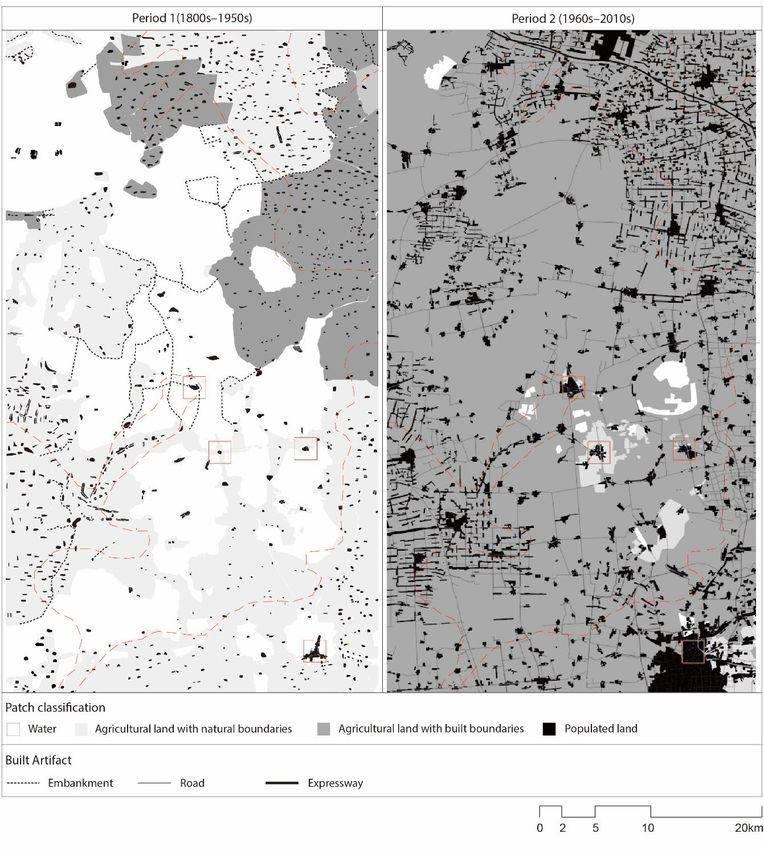
Dongxue Lei

particularly common in Asia’s densely populated mega-river basins. For example, cities
located within the large flood plains of China’s Yangtze, Yellow, and Huai Rivers are at the
risk of flooding in heavy rainy seasons, while villages within floodwater retention areas are
the most flood-prone locales. Another example is ‘chars’, a type of river island inhabited by
marginalized communities, which seasonally appears in the deltaic flood plains of Bengal
(Lahiri-Dutt, 2014b; Lafaye de Micheaux et al, 2018).
       Wetlands are also low-lying landscapes that are perennially or periodically saturated with
water (Mitsch & Gosselink, 2011) and, in some cases, included in a broad flood plain (Tockner
& Stanford, 2002). Although wetlands are challenging environments to live with, they
provide human development with diverse values (Mitsch & Gosselink, 2000). Not only do
wetlands serve as homes for premodern and contemporary rural inhabitants (Pinke et al, 2016;
Krause, 2017; Robertson & McGee, 2003; Ambastha et al, 2007), but they are also the origin
of modern island cities such as Paris and Mexico City (Giblett, 2016; Mitsch & Gosselink,
2011). As Griblett (2016) observes, natural disasters can take a former wetland city back to its
“wetland beginning.” Therefore, some former wetland cities that cannot be categorized into
typical types of island cities may inherit islandness (e.g. Berlin). Some inland and coastal cities
of Asia can also be recognized as island cities as their modern development remains in the
background of a wide range of wetland legacies (Dar et al, 2020; Ummai et al, 2011; Guan,
2021). Other than being transformed into urban/rural dwellings, flood plains and wetlands
can be converted into artificial waterscapes, such as rice paddies and aquaculture ponds.
Settlements situated in artificial waterscapes can thus also be perceived as islands.
       The present study introduces a group of island settlements from the lowlands of Lixiahe
(里下河), China, which were built in natural waterscapes hundreds of years ago and are now
still developing in artificial waterscapes (Figure 1, left). The phenomenon of dwelling on
islands in this wet landscape needs to be understood in terms of natural as well as social aspects.
By virtue of an average terrain of less than two meters above sea level, these lowlands have
been endowed with a wet landscape since ancient times. In the past, this area was a lagoon,
which formed around the 5th Century BC. As the coastline continually moved eastward, and
the former Yellow River transported large amounts of sediment into the area in the 16th
Century AD (Ye, 1986), the lagoon eventually transformed into mixed waterscapes of shallow
lakes, wetlands and rivers. Ancient inhabitants succeeded in settling down by building islands
in the mixed waterscapes. According to archaeological evidence and gazetteer records, the
first population boom in this lowlands was seen during the Eastern Han dynasty (25-220 AD),
and a stable island society occasioned by forced immigration emerged in the Ming dynasty
(1368-1644). Another island or archipelagic society emerging in an equally wet landscape can
be found around Lake Tai on the south Yangtze River deltaic plain.

                                                63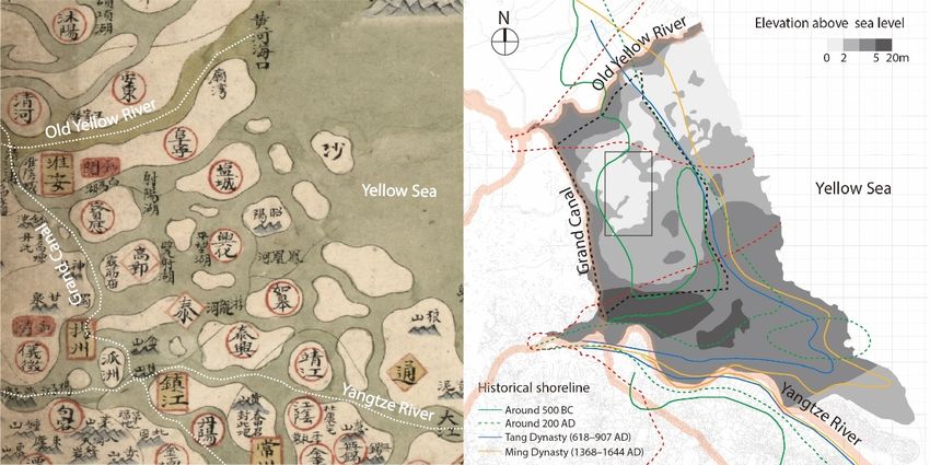
Island Studies Journal, 16(1), 2021, 62-80

Figure 1. Left: A cognitive map of island settlements in the Lixiahe region around the mid-
18th Century. Right: Map of the Lixiahe region and study area. The area with red dashed lines
represents the geographical domains of the abandoned Yellow River delta (Ye, 1986; Ha et
al, 2005) and Yangtze River delta (Chen, 198). The black dashed lines mark the official
borders of Lixiahe. The study area is shown by the black rectangle.

       Yet dwelling on islands was not easy in premodern times because the water-land nexus
of this wet landscape was extremely unstable. Frequent disasters occurred in the lowlands due
to the Lixiahe region’s unique topography. Under the dual effects of geological transitions
and sea-level changes, Lixiahe was developed from the old delta lands of the Yangtze and
Yellow Rivers. Eventually, this plain evolved with a bowl-shaped landform, and the lowlands
are situated at its bottom (Figure 1, right). Besides the permanent bodies of water in the
lowlands, there are other sources of water input. Water disasters, including floods and
waterlogging caused by monsoon rains and typhoon rains, hit the lowlands frequently
between the 14th and 19th Centuries (Zhang, Chen, & Gu, 2016). Floodwaters from the Grand
Canal, the Old Yellow River (Huai River), and the Yangtze River frequently flowed into
the lowlands before the 20th Century (Xu, 1995).
       This wet landscape is also prone to problems associated with dry conditions. During the
dry season, the area receives less water than is required by agricultural irrigation systems, bearing
in mind the rapid rate of evaporation from the broad expanses of surface water. According to
local records, extreme water disasters and droughts occurred around once every two years
between 1853-1949. In the face of the dynamic wet conditions, islanders built artifacts that
functionally and symbolically negotiate with this instability: for example, constructing islands
adjacent to other islands and connecting them by bridges, utilizing embankments and walls
to intervene in the water-land nexus, and setting up temples to pray for safety.
       To create more stable water-land environments, human interventions within Lixiahe
have been greatly intensified in modern times. Due to the implementation of numerous water
conservancy projects (Liu et al, 2013), including the building of drainage systems, pumping
stations, and polders (Xu, 1995), the frequency of extreme flooding and droughts in the lowlands
decreased to once every five years between 1949-2000 (兴化市防汛防旱指挥部办公室,

                                                 64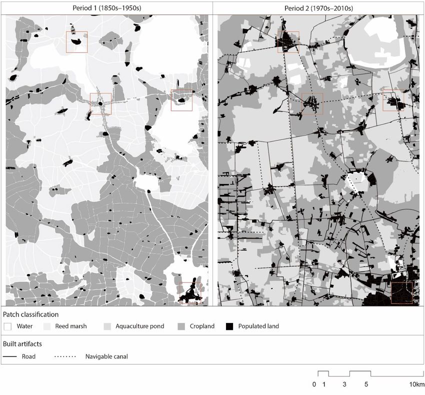
Dongxue Lei

2001). At the same time, the wet landscape of the lowlands has been thoroughly reshaped. For a
long time, the lowlands’ wet conditions have been regarded as a negative factor in social life
and economic activities, and the wet landscape has been considered a wasteland. Therefore,
under the driving force of the national-led agricultural modernization and subsequent rural
urbanization, natural waterscapes experienced massive land reclamation and were converted
into ground-bases for diverse built artifacts (buildings, aquacultural ponds, etc.). In this enduring
dry development, the natural wetness of the lowlands has been reduced to a minimum.
       Human intervention in dynamic water-land environments is a permanent theme in this
wet landscape. Such interventions are realized through building behavior and then embodied
by built artifacts (McGrath & Lei, 2021). Using fieldwork, gazetteers, historical maps, and
multi-disciplinary research, we can find records of various built behaviors and artifacts in the
evolution of these lowland islands. The present paper presents socio-natural interactions in
the lowlands in both premodern and modern times and analyses their consequences. Based on
a long-term perspective, this study further investigates the degree to which the natural settings
of the lowlands affect social dynamics in modern times. The two study periods are defined
according to the history of rural China. The beginning of premodern history in Lixiahe goes
back to the 16th Century, when a large group of island settlements began to thrive materially,
eventually achieving a stable morphology that lasted for centuries. Up until the 1950s, the
lowlands retained most of their natural waterscapes. The period from the 1950s up to the
most recent (2010-2019) is defined as the modern period, during which both natural and
social environments have undergone tremendous changes, with the drying out of the lowlands.
       The present study’s broad geographical scope allows it to contribute to explorations of
island relations and archipelagic thinking in island studies (Stratford et al, 2011; Pugh, 2013,
2018; Stratford, 2013). Observations of this island society are synchronically conducted at
three levels: individual island, island corridor, and archipelago. These three levels are not
independent; understanding the consequences of socio-natural interactions at one level is
necessary for understanding those at the other two levels. It should be noted that the starting
and ending times of the two periods differ between levels because the specific socio-natural
interactions at the three levels were of different durations.

A boundary approach

Because we will explore socio-natural interactions, the natural and built environments must
be considered as whole on every level. Inspired by the boundary framework from landscape
ecology (Cadenasso & Pickett, 2003), this study focuses on the boundaries of one or more
islands on the landscape scale to reveal complex socio-natural interactions. The boundary
framework is applicable in this study because it has been devised as an interdisciplinary
approach to understanding the inclusion of humans and the organization of their built artifacts
within an ecosystem (McGrath et al, 2007). This approach is, moreover, applicable to
researching objects at any spatial scale and places emphasis on the temporal as well as spatial
dimensions of a research context.
      In landscape ecology, “landscapes consist of two kinds of structures—patches and
boundaries” (Cadenasso et al, 2003, p. 751). Patches are “volumes that can be distinguished
compositionally, structurally, or functionally from adjacent volume at a given scale”
(Cadenasso et al, 2003, p. 751), representing spatial heterogeneity that can exist in “bodies of

                                                 65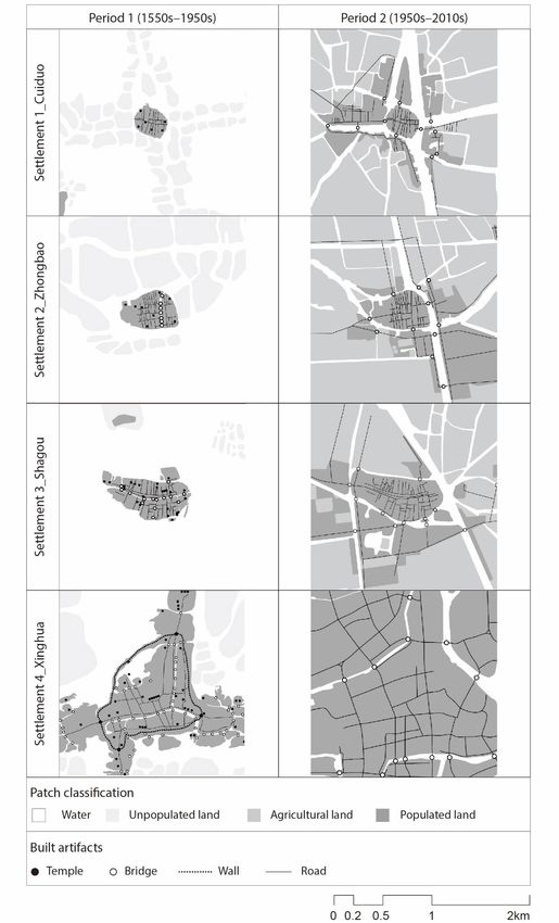
Island Studies Journal, 16(1), 2021, 62-80

water, volumes of soil, and land-water transitions” (Cadenasso et al, 2003, p. 750). Boundaries
are structural and functional entities between patches, through which patches interact in the
flows (Cadenasso & Pickett, 2007). Based on this interpretation, the water-land environments,
including islands, can be viewed as an assemblage of different types of heterogeneous patches,
and boundaries can be defined as a water-land interface that structurally and functionally
supports the existence of one or more islands.
       The boundary framework is viewed as an observational tool in this study. First, it
provides two hints to assist in analyzing boundary structure and function (Cadenasso &
Pickett, 2007). Boundaries are three-dimensional and composed of architectural,
compositional, symbolic, or perceptual features, and can be wide or narrow, sharp or subtle.
Moreover, boundary function can be disturbed by boundary structure as boundaries serve as
a medium facilitating exchange of materials, energy, organisms, or information between
patches. Therefore, analysis of the structure of the water-land interface should include artificial
as well as natural elements, and the function of the water-land interface can be revealed by
analyzing the motivation of built behavior in intervening at the water-land nexus.
       Apart from supporting the textual interpretations of boundary structure and function,
the boundary framework expands its applied field to morphological analysis and argues that
the existence of boundaries can be visualized by patch contrast. To represent the water-land
interface in a wet landscape, patch classification needs to move away from the water-land
dichotomy, which originates from the nature-culture binary in multiple disciplines (Krause,
2017; Lahiri-Dutt, 2014a; Hayward, 2012; Stratford et al, 2011). For example, a patch of rice
paddies or aquaculture ponds can be considered aquatic or terrestrial depending on the specific
research context. Therefore, it is essential to first recognize that there is a gradient between
water and land in a wet landscape and thus that water-land environments need to be
subdivided as in Table 1 below.

Table 1. Patch classification in the context of wet landscape.
  Class 1    Water       Water-Land                            Land
  Class 2    Lake/       Reed marsh/                           Unpopulated land/
             River       Waterlogged paddy field/              Raised field/
                         Paddy field with embankments/         Populated land
                         Aquaculture pond

      As ecologists have suggested, the function of even the same patches varies in accordance
with spatial level (Cadenasso & Pickett, 2007). This means that the above types of patches in
Class 2 need to be regrouped in accordance with the research context of each level. Here,
the intensity of human interventions is employed to devise a new classification (see Table 2
below). A certain type of patch may be removed on one level as it has little relationship to
the research question. For example, the ‘river’ patch is ignored on Level 3 as it does not
contribute to the phenomenon of boundaries of an archipelago. On each level, two periods
share the same classification rule to illustrate and compare the impact of human interventions
on the morphological transformation of the lowland islands.

                                                66
Dongxue Lei
Table 2. Patch classification on each level.
Level 1 Level 2 Level 3
Class 1 Class 2 Class 1 Class 2 Class 1 Class 2
Water Lake/River/Reed Water Lake/River Water Lake/Reed marsh
marsh
Unpopulated Unpopulated land Reed marsh Reed marsh Agricultural land Waterlogged
land with natural paddy field/
boundaries Raised field
Agricultural Waterlogged Aquaculture Aquaculture pond Agricultural land Paddy field with
land paddy field/ pond with built embankments/
Paddy field with boundaries Aquaculture pond
embankments/
Raised field/
Aquaculture pond
Populated Populated land Cropland Waterlogged Populated Populated
land paddy field/ land land
Paddy field with
embankments/
Raised field/
Populated Populated land
land
Level 1: Individual island
The strategy of constructing islands in the lowlands is operationally easy and sustainable. Early
inhabitants raised elevated lands in the water by stacking mud and ultimately expanded these
islands as their community grew. Surrounding the populated islands, vacant elevated lands
were reclaimed as raised fields to cultivate vegetable crops, which is comparable to the ancient
farming patterns of the Chinampas in the Valley of Mexico. Swamps with natural lower
landforms are more commonly transformed into waterlogged paddy fields (Yuan & Wang,
2019). Inhabitants traveled among islands by boat in their daily lives.
In this section, the analysis of boundary structure and function is first given to four
island settlements in premodern times (Figure 2, left). In the case of Cuiduo (崔垛), besides
the boundary that is marked by water and land, island boundaries can be reflected in the edge
space of the road system. Meanwhile, several temples with cultural symbolism are located at
the periphery of the island. The second case, Zhongbao (中堡), further exemplifies the built
behavior when the territory of the island community expands to two pieces of land. Bridges
are built at regular intervals to connect two single islands. Temples also appear along the
periphery of this island settlement. These two cases suggest that the boundary structure of an
island settlement includes water and temples. The existence of boundaries is highlighted by
the locational information of temples, and the function of the water boundary in separating
an island community can be weakened by bridges.
Shagou (沙沟) is a more detailed case for examining the above inference. With a
recorded history of around 2000 years, Shagou is probably among the earliest island
settlements in the lowlands. It was built by the first generation of immigrants during the
Warring States period (475-221 BC). Unlike Cuiduo and Zhongbao, the territories of which
67Island Studies Journal, 16(1), 2021, 62-80
are contained within one or two islands, the built-up area of Shagou expanded from one
island to five islands, according to oral history. By examining the spatial-temporal information
of bridges and temples, it is possible to reveal the morphological development of this island
settlement. It can be verified that there are always newly built temples and bridges when this
community develops from the east to the west. The widespread distribution of bridges ensures
high accessibility to each populated land, and thus the water boundary has limited effect on
mobility within this community. The continuous behavior of building temples underlines the
need to extend a sense of place and construct new boundary structures amidst the
development of this island community.
These three cases illuminate how inhabitants adopt an island model to remain on land
and out of the water, while Xinghua (兴化) presents how an island community may
proactively engage with the unstable and wet conditions of the lowlands by intervening in
the boundary structure. This idea is realized by the building of a wall. In common with other
city walls in China’s imperial dynasties (Chang, 1970), Xinghua’s wall was initially set up for
military defense and flood control. In addition, the wall was partially erected between water
and land and therefore created a shallow pond within the walled community. The pond not
only served as a temporal water source in dry seasons but also as a water storage area during
floods. Over time, this kind of boundary structure can influence the original water-land
boundaries because sediments easily accumulate near the outer wall. As new pieces of land
appeared, the territory of this island community continued to grow beyond the wall. This
can be verified by the densely built bridges and regularly distributed temples outside the wall.
By the 1950s, bodies of water surrounding and within these island settlements experienced
recession and pollution, and their boundary functions drastically decreased. To cope with the
environmental problems that occurred in this wet landscape, a series of infrastructural projects
were carried out to promote a dry form of development. Rivers within island settlements
were filled and converted to roads, and both walls and bridges were torn down to develop
road systems. Swamps were gradually converted into various kinds of agricultural lands, and
temples associated with the water-oriented culture were demolished. This dry development
accelerated due to the development of small-scale enterprises driven by China’s 1978 rural
economic reforms (Jin, 1988). Since the 1980s, the environmental conditions of the four
island settlements have transformed from a wet scenario to a dry scenario. In the modern
period, the boundaries composed of artificial waterscapes may appear to isolate the islands,
but their function is largely visual, given that roads and bridges have become the functional
medium through which island settlements connect with their outside world (Figure 2, right).
68Dongxue Lei
Figure 2. Islands in premodern waterscapes (Period 1) versus in modern dry development
(Period 2).
69Island Studies Journal, 16(1), 2021, 62-80
Level 2: Island Corridor
Island boundaries share similar information regarding structure and function in premodern
times, but what are the drivers of different degrees of built behavior in this wet landscape?
For example, Shagou grew from an individual island into five islands despite being isolated
by water in all directions, and Xinghua was in fact a walled compound of land and water. We
can examine boundary structure and function at the larger scale of the wet landscape to
understand these morphological differences. Patch classification must be re-designated to
achieve a more elaborate differentiation between water and land at this scale. On this level,
lakes and reed marshes constitute wide boundaries and function as a versatile medium (Figure
3, left). These bodies of water can both slow floodwater during periods of flooding and
provide irrigation water in dry seasons. Reed marshes can also function as a three-dimensional
barrier, protecting islands from intrusion. It is recorded that island settlements survived pirate
attacks in the Ming dynasty (Matsuura, 1997) and were selected for military bases in the
second Sino-Japanese war (1937-1945) and the Chinese Civil War (1945-1949).
These functional boundaries have a crucial impact on the emergence of island
settlements and the thriving of island society. This can be directly verified by the history of
the island settlements in the lowlands. Xinghua was first founded as a Hsien (county-level city
in the agrarian society) as late as the 10th Century AD, which is unusual because other walled
cities in Lixiahe were founded much earlier, before the 3rd Century BC. For example, Yancheng
(盐城), which was situated in a more vulnerable coastal area, was founded around 200 BC.
Historians have argued that a Hsien was established in the lowlands in order to regulate the
growing local population (丁 & 汪, 1929). Cuiduo and Zhongbao appeared later and were
founded by a group of forced immigrants from the south Yangtze River delta area in the 14th
Century. The same group of immigrants built most of the island settlements in the lowlands
despite the lowlands being hit by severe natural disasters on an annual basis in this period.
Under these specific social and natural contexts, a water corridor system connecting island
settlements emerged in the mid-19th Century (Figure 3, left). Isolated islands are connected
through water trails in reed marshes or between paddy fields. The water corridor network,
centered on Xinghua in a radiating pattern, is visually distinguished from the others due to its
spatial continuity in the water-land environments. Between the mid-16th and 18th Centuries,
these lowlands became a traffic node supporting commodity exchanges within the Lixiahe
region. Xinghua, the administrative center, served as a hub for collecting grain, which was a
major source of state revenue. Some island settlements in this water corridor network had
served as market towns for centuries. For example, Zhongbao is a market town on a latitudinal
water corridor connecting the coastal salt fields and the eastern plains, while the market town
of Shagou is on a longitudinal water corridor connecting the northern and southern plains.
Since the mid-20th Century, island relations based on the water corridor system have
been altered. First, a new social order was established in the lowlands shortly after the start of
the socialist era. In the years 1958-1983, island settlements were recombined into a three-tier
socio system (O’Leary & Watson, 1982) aimed at maximizing the spatio-economic benefits
of agricultural production (兴化县地名录, 1983). As a result, socio-economic relations
among island settlements were embedded into different spatial clusters for collective
management. In the 1970s, tremendous efforts were made to construct waterways with the
70Dongxue Lei
aim of improving the drainage capacity of this lowland watershed. Accordingly, the
meandering natural waterways were straightened and widened, and some were replaced by
navigable canals. Such adjustments in the water corridor system appear slight when considered
on the regional level, but when seen at the level of the individual island, they meant that
some island settlements were removed from their earlier island-to-island relations.
The integration of land transportation within Lixiahe since the 1970s accounts for the
most decisive driver for the formation of new island relations (Figure 3, right). With intense
road construction, the rhizomatic water corridor system has been replaced by an orthogonal
land corridor system. Over the past decades, the maturing land corridor system has increased
accessibility to each island settlement, but it has also weakened the significance of the
boundary functions originating from the wet landscape, thereby detaching the development
of island settlements from their earlier water-land environments. To support this argument,
one can, for example, note the remarkable size differences of the built-up areas between the
islands adjacent to and away from roads and the emergence of a large group of modern
settlements in the southwest lowlands. These phenomena demonstrate the bottom-up
breakage between social dynamics and the water-land environments.
Figure 3. Island premodern water corridors (Period 1) versus modern land corridors
(Period 2).
71Island Studies Journal, 16(1), 2021, 62-80
Level 3: Archipelago
When we continue to step back and look at the lowlands using a coarser resolution, it is easy
to identify the existence of an archipelago (Figure 4, left). Morphological information on this
level indicates that the archipelago not only exists within natural waterscapes but is also
attached to artificial waterscapes of paddy fields. Therefore, the archipelago is the third level
to examine boundary structure and function, and consideration needs to be given to the
socio-natural interactions taking place between the lowlands and the uplands. Here,
‘lowlands’ and ‘uplands’ are relative concepts, considering the bowl-shaped landform of
Lixiahe. As the lowlands are at the bottom of the plain, the part of the plain with higher
elevations can be defined as the uplands. Settlements in the uplands can also be regarded as
islands but are situated in a somewhat drier landscape. The development of the upland island
settlements follows a similar morphological logic to that of the lowland island settlements, but
the degrees of human intervention in the water-land environment differ in the two areas.
In premodern times, Lixiahe’s waterlogged paddy fields, which had been transformed
from low-lying bodies of water, were the predominant spaces of agricultural cultivation. This
agricultural mode is easily achieved by utilizing the microtopography of the lowlands (Yuan
& Wang, 2019) but is highly prone to flooding and droughts. In response to more frequent
flooding in the 18th Century, islanders in the uplands adopted an embankment system as a
proactive response to environmental instability (吴, 1996). This system involves organizing
living and farming activities within the same area and permits a controlled water-land nexus
through the construction of layered embankments. Generally, the outer embankments are
half a meter higher than the highest water level in the rainy season to prevent flooding,
whereas the height of paddy fields is lower than the annual mean water level to achieve gravity
irrigation in the dry season. In extreme conditions, islanders constructed temporary dams
surrounding the living areas and transformed paddy fields into floodwater retention areas. In
this system, the paddy fields are protected by embankments while the island community is
protected by the paddy fields with embankments.
With long-term success in the uplands, this embankment system was introduced to the
lowlands from the 18th to the early 19th Centuries (阮性传, 民国). Although the system is
derived from systematic thinking, its construction process relies upon self-organization and is
focused on the water-land nexus within the territory of an individual settlement, rather than
within the wider Lixiahe region. The unorganized embankments destroyed the water corridor
system and caused blockages in water channels due to increased subsidence, which eventually
prevented water from flowing into and away from the lowlands. This built behavior on the
individual island level intensified the extreme conditions of the water-land nexus in the
lowlands: that is, there was frequently either no water or an excess of water. To increase their
ability to control water flows, lowland islanders still resorted to the embankment method in
the first half of the 20th Century (Figure 4, left). This behavior further worsened the water
shortages in the lowlands in the second half of the 20th Century, which matches the time node
when rivers were polluted and filled on the Level 1.
From the 1960s to the 1970s, under the impetus of the national strategy of “scientifically
rational utilization of all available agricultural resources” (Chang, 1981), higher and longer
embankments were built in Lixiahe to create more resilient paddy fields. At the same time,
72Dongxue Lei
lakes and reed marshes in the lowlands were reclaimed as paddy fields from the late 1950s to
the 1970s and then transformed into aquaculture ponds between the 1980s and 1990s (Wang et
al, 2019). By the 2000s, Lixiahe’s natural waterscapes were thoroughly transformed into artificial
waterscapes with a stable water-land nexus. Within a short period, these drier conditions
reduced consciousness of periodic natural disasters. New settlements began appearing, primarily
located along the boundaries between the uplands and lowlands. As artificial waterscapes
expand in the two areas, spatial heterogeneity between the lowlands and uplands diminishes,
and it seems that the boundaries of the archipelago no longer exist (Figure 4, right).
As a matter of fact, the modern land corridor system has isolated island settlements from
the Lixiahe ecosystem. In the early 1970s, highways were built in the uplands due to the
prioritization of economic development. The construction of these land arteries prompted
rapid industrialization of the uplands in the 1980s, leading to even wider highway network
coverage within the uplands in the following decade. In the same period, however, there was
only one interregional highway connecting the lowlands and uplands. To develop land
transportation in the lowlands and ensure economic efficiency, island settlements were
integrated into several land corridor networks belonging to different political administrations
in the uplands. Access to lowland settlements was thus determined by their spatial proximity
to upland settlements. As a result, lowland island settlements were positioned as the end nodes
of transportation networks, becoming the remotest parts of the Lixiahe plains.
This sense of spatial remoteness has produced demographic changes, as younger islanders
increasingly flee the lowlands and migrate to more urbanized, developed, and drier areas. The
ancient lowlands society has become a socio-economic backwater of the Lixiahe region in
modern times. Meanwhile, a series of environmental crises, including water quality problems
and a return of issues connected with natural disasters, make life in the lowlands more challenging.
Over the past decade, there has been a river-lake-wetland restoration movement in the
lowlands, driven by environmental performance evaluations and the rural revitalization
movement. By decreasing illegal aquaculture ponds that were constructed before the 2000s
and promoting ecological aquaculture methods, local governments have begun the process of
eco-environmental restoration (刘 et al, 2015; Wang et al, 2019). Some island settlements
have sought to recreate picturesque water villages by restoring the formerly covered rivers
and providing riverine leisure activities, which are expected to promote the tourism economy
(Figure 5). An identity assemblage is emerging in the lowlands: an isolated archipelago that
serves same-day tourism as well as an aquapelago (Hayward, 2012) that supports daily socio-
economic life.
73Island Studies Journal, 16(1), 2021, 62-80
Figure 4. Environmental change from a premodern waterscape (Period 1) to a modern
landscape (Period 2), with red dash lines marking the rough boundary between the lowlands
and uplands.
74Dongxue Lei
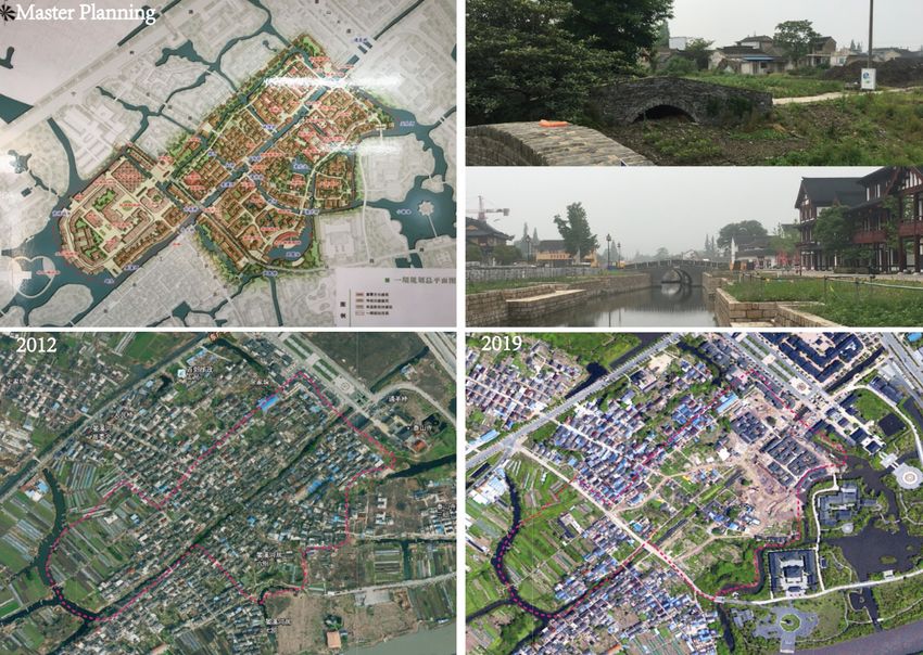
Figure 5. The island settlement of Xixi (西溪) under reconstruction driven by tourism
development. The top-right two images show a previously paved-over river and a
reconstructed riverine public place within this settlement. Below, two satellite maps illustrate
the transformation of this settlement between 2012-2019 Satellite image source:
http://jiangsu.tianditu.gov.cn/server/index
Conclusion and discussion
Tracing the interwoven socio-natural relationships in two periods on three levels reveals that
Lixiahe’s island societies and water-land environments constitute a complex socio-natural
system (Van der Leeuw & Aschan-Leygonie, 2005; Holling, 1973). Empirical knowledge of
resilience generated from this model might provide historical lessons for places that are still
undergoing dry development as part of modernization or urbanization processes in other wet
landscapes (Grydehøj & Casagrande, 2020; Pittock, 2019; Ashraf, 2014). In addition, the
boundary approach is applicable to island studies on the relationship between social dynamics
and natural environments.
To conclude, a diachronic observation provided three perspectives to link resilience in
a socio-natural system and planning/architectural practice in wet landscapes.
1. The nested mechanism. Island settlements should be considered as part of this socio-
natural system rather than as spatially discrete entities. They cannot be completely separated
from wet conditions despite the intensive dry development in modern times. As shown in
the analysis of the modern period, an overwhelming dry development can trigger a series of
crises. This socio-natural system needs to be further explored in “flow-structures” (Van der
Leeuw & Aschan-Leygonie, 2005) instead of statically hierarchical structures because one
75Island Studies Journal, 16(1), 2021, 62-80
hidden driver of the evolution of the island society is the water-land nexus, which is essentially
a flowing process in nature. The flow structures can be further unveiled by the nested
relationships among three levels. Individual island settlements were conditioned by the
environment of the lowlands. The socio-natural order generated by cooperation among island
settlements (see Level 2, island corridor) can influence social dynamics on both the individual
island and archipelago levels. For example, island settlements owe their morphological
differentiations to their spatial relationships within the island corridor systems, while the
emergence of the archipelago or aquapelago is a result of socio-economic dynamics facilitated
by the island corridor systems. This nested mechanism may help explain why a variety of
crises sprung up so quickly in the dry scenario of the modern period. If anything, modernity
has enhanced this nested mechanism: dry development on every level can accelerate the pace
of development and change within this socio-natural system.
2. The effects of built artifacts. Built artifacts work as a medium for revealing the water-
land nexus and intervening in water-land environments. A tentative conclusion to the recent
river-lake-wetland restoration movement is that there will be a substantial expansion of
waterscape areas in the future in response to diverse ‘dry’ crises. This raises questions about
how to alleviate the space use conflict between water-based ecological benefits and land-based
economic development. One hypothesis is that built artifacts, such as infrastructure and public
buildings, can work as agents to synergize aquatic and terrestrial flows (logistics, socio-cultural
activities, etc.). Therefore, future construction projects should consider the socio-economic
activities that can be synchronically fostered by water and land environments because the
dynamic water-land nexus is an enduring characteristic of the lowlands. Another hypothesis
could be that the effects of the built artifacts are conditioned by socio-natural interactions,
which remain subject to the nested mechanism, and that such effects need to be evaluated
from a long-term perspective. This means that enhancing resilience on one level through
building artifacts might have an impact on resilience on another level in the future. For
example, constructing embankments on Level 1 was initially a success; however, it led to the
deterioration of the water corridor system on Level 2 and, in turn, induced more intensive
embankment construction on Level 3, which eventually triggered even more severe droughts
and flooding. This is also in accord with the findings of scientific studies that artificial
adjustment within low-grade river networks impacts the function of the fluvial system
(Gregory, 2006; Sear & Newson, 2003). If the restoration movement succeeds in promoting
the tourism economy, one could question whether the recreation of river channels and other
bodies of water on the individual island level might trigger the same built behavior on other
levels and cause environmental degradation. It could be possible and informative to forecast
the consequences of this built behavior, considering that researchers have set out to monitor
and evaluate the changed river networks within Lixiahe in modern dry development (Lv et
al, 2018; Zhou et al, 2018).
3. The twin phenomena. A comparative study of two time periods informs us that there
are three kinds of twin phenomena that recur in the evolution of this island society. First, wet
conditions alternate with dry conditions in the lowlands: there are “rhythms of wet and dry”
(Krause, 2017) in this wet landscape. Despite the significant decline in natural disasters in
modern times, moderate waterlogging occurred in the southern lowlands in 2006, and
moderate drought was seen in the northern lowlands in 2019. Design interventions for
environmental resilience thus need to be able to respond to both overly wet and dry
76Dongxue Lei
conditions. Second, it should be acknowledged that environmental and social crises are the
results of socio-natural interactions (Van der Leeuw & Aschan-Leygonie, 2005). Natural and
social dynamics are interrelated in the lowland context. This study has demonstrated that the
natural settings of the lowlands still play a role in the modern socio-economic dynamics of
this island society. But the recreation and maintenance of the physical form of an island or
archipelago as part of tourism initiatives seems to be unsustainable as the relationship between
natural environments and social dynamics is merely supported by the seasonal tourism
economy. Third, bottom-up and top-down actions are interrelated; they can cause crises for
one another when embedded within cultural preference. For example, massive land
reclamation within individual settlements exacerbated the overall dry condition in the
lowlands, and modern planning ignoring the socio-natural interactions led to the current
trend of migration in island settlements.
Binary conceptions of wet/dry, natural/social, and bottom-up/top-down affect the
consequences of human interventions in this wet landscape. Thinking about these twin
phenomena might enhance design thinking in relation to resilience in socio-natural systems.
Acknowledgements
This study has benefited from discussions with Brian McGrath (Parsons School of Design).
Comments and suggestions from Brian McGrath, David Grahame Shane (Columbia
University), anonymous reviewers, the editors of Island Studies Journal, and Likai Wang
(Nanjing University) are grateful acknowledged. I am also grateful for the financial support
from the China Scholarship Council (No. 201806190192) and the Postgraduate Research &
Practice Innovation Program of Jiangsu Province, China (No. KYCX10_005).
References in English
Ambastha, K., Hussain, S. A., & Badola, R. (2007). Resource dependence and attitudes of
local people toward conservation of Kabartal wetland: A case study from the Indo-
Gangetic plains. Wetlands Ecology and Management, 15(4), 287.
https://doi.org/10.1007/s11273-006-9029-z
Ashraf, K. (2014). Water as Ground. In Mathur, A., & Da Cunha, D. (Eds). Design in the
terrain of water (pp. 83-97). Applied Research + Design Publishing.
Cadenasso, M. L., & Pickett, S. T. A. (2007). Boundaries as structural and functional entities
in landscapes: Understanding flows in ecology and urban design. In Designing Patch
Dynamics. New York: GSAPP, Columbia University.
Cadenasso, M. L., Pickett, S. T., Weathers, K. C., & Jones, C. G. (2003). A framework for a
theory of ecological boundaries. BioScience, 53(8), 750-758.
https://doi.org/10.1641/0006-3568(2003)053[0750:affato]2.0.co;2
Chang, S. D. (1981). Modernization and China’s urban development. Annals of the Association
of American Geographers, 71(2), 202-219.
Chang, S. D. (1970). Some observations on the morphology of Chinese walled cities. Annals
of the Association of American Geographers, 60(1), 63-91. https://doi.org/10.1111/j.1467-
8306.1970.tb00704.x
77Island Studies Journal, 16(1), 2021, 62-80
Chen, X. (1998). Changjiang (Yangtze) River Delta, China. Journal of Coastal Research, 14(3),
839-858.
Dar, S. A., Bhat, S. U., Rashid, I., & Dar, S. A. (2020). Current status of wetlands in Srinagar
City: threats, management strategies, and future perspectives. Frontiers in Environmental
Science, 7, 199. https://doi.org/10.3389/fenvs.2019.00199
Giblett, R. (2016). Cities and wetlands: the return of the repressed in nature and culture. Bloomsbury.
Gregory, K. J. (2006). The human role in changing river channels. Geomorphology, 79(3-4),
172-191. https://doi.org/10.1016/j.geomorph.2006.06.018
Grydehøj, A. (2015). Island city formation and urban island studies. Area, 47(4), 429-435.
https://doi.org/10.1111/area.12207
Grydehøj, A., & Casagrande, M. (2020). Islands of connectivity: Archipelago relationality and
transport infrastructure in Venice Lagoon. Area, 52(1), 56-64.
https://doi.org/10.1111/area.12529
Grydehøj, A., Pinya, X. B., Cooke, G., Doratlı, N., Elewa, A., Kelman, I., & Swaminathan,
R. (2015). Returning from the horizon: introducing urban island studies. Urban Island
Studies, 1, 1-19. https://doi.org/10.20958/uis.2015.1
Guan, Y., Bai, J., Tian, X., Zhi, L., & Yu, Z. (2021). Integrating ecological and socio-
economic systems by carbon metabolism in a typical wetland city of China. Journal of
Cleaner Production, 279, 123342. https://doi.org/10.1016/j.jclepro.2020.123342
Ha, C., Zhu, J., Ye, N., Huang, J., Gong, J., & Lu, H. (2005). Formation and evolution of
a forgotten Delta -- the Huaihe River delta, eastern China. Geological Bulletin of China,
24(12), 1094-1106.
Hayward, P. (2012). Aquapelagos and aquapelagic assemblages. Shima, 6(1), 1-10.
Holling, C. S. (1973). Resilience and stability of ecological systems. Annual Review of Ecology
and Systematics, 4(1), 1-23.
Jin, Q. (1988). The history and current trends of research on rural settlement geography in
China. Acta Geographica Sinica, 55(4), 311-317. (in Chinese with English abstract)
Krause, F. (2017). Rhythms of wet and dry: Temporalising the land-water nexus. Geoforum.
https://doi.org/10.1016/j.geoforum.2017.12.001
Lafaye de Micheaux, F., Mukherjee, J., & Kull, C. A. (2018). When hydrosociality
encounters sediments: Transformed lives and livelihoods in the lower basin of the
Ganges River. Environment and Planning E: Nature and Space, 1(4), 641-663.
https://doi.org/10.1177/2514848618813768
Lahiri-Dut, K. (2014a). Beyond the water-land binary in geography: Water/lands of Bengal
re-visioning hybridity Kuntala Lahiri-Dut. ACME: An International Journal for Critical
Geographies, 13(3), 505-529.
Lahiri-Dutt, L. (2014b). Chars islands that float within rivers. Shima: The International
Journal of Research into Island Cultures, 8(2), 22-38.
Liu, J., Zang, C., Tian, S., Liu, J., Yang, H., Jia, S., You, L., Liu, B., & Zhang, M. (2013).
Water conservancy projects in China: Achievements, challenges and way
forward. Global Environmental Change, 23(3), 633-643.
https://doi.org/10.1016/j.gloenvcha.2013.02.002
78Dongxue Lei
Lv, H., Zhou, F., Li, N., & Xu, Y. (2018). Evolution Characteristics of the River Network
in the Typical Area of Lixiahe Region. Resources and Environment in the Yangtze Basin,
27(2), 380-385. (in Chinese with English abstract)
Matsuura, A. (1997). The Chinese Pirates During the Ming and Qing Dynasty [J]. Studies In
Qing History, 1. (in Chinese with English abstract)
McGrath, B., Marshall, V., Cadenasso, M.L., Grove, J.M., Pickett, S.T.A., & Towers, J.
(Eds). (2007). Designing Patch Dynamics. Columbia University Graduate School of
Architecture, Preservation and Planning.
McGrath, B., & Lei, D. (2021). The embodied resilience of architecture and built form. In
Ungar, M. (Eds). Multisystemic resilience: Adaptation and transformation in contexts of change.
Oxford University Press. https://doi.org/10.1093/oso/9780190095888.003.0032
Mitsch, W. J., & Gosselink, J. G. (2000). The value of wetlands: importance of scale and landscape
setting. Ecological Economics, 35(1), 25-33. https://doi.org/10.1016/s0921-8009(00)00165-8
Mitsch, W. J., & Gosselink, J. G. (2011). Wetlands. John Wiley & Sons.
O’Leary, G., & Watson, A. (1982). The role of the People’s Commune in rural development
in China. Pacific Affairs, 55(4), 593-612. https://doi.org/10.2307/2756843
Pinke, Z., Ferenczi, L., Gábris, G., & Nagy, B. (2016). Settlement patterns as indicators of
water level rising? Case study on the wetlands of the Great Hungarian Plain. Quaternary
International, 415, 204-215. https://doi.org/10.1016/j.quaint.2015.11.032
Pugh, J. (2013). Island movements: thinking with the archipelago. Island Studies Journal, 8(1),
9-24.
Pugh, J. (2018). Relationality and island studies in the Anthropocene. Island Studies Journal,
13(2), 93-110. https://doi.org/10.24043/isj.48
Pittock, J., & Connell, D. (2019). Dikes, rice, and fish: how rapid changes in land use and
hydrology have transformed agriculture and subsistence living in the Mekong Delta. Regional
Environmental Change, 19(7), 2069-2077. https://doi.org/10.1007/s10113-019-01548-x
Robertson, H. A., & McGee, T. K. (2003). Applying local knowledge: the contribution of
oral history to wetland rehabilitation at Kanyapella Basin, Australia. Journal of environmental
management, 69(3), 275-287. https://doi.org/10.1016/s0301-4797(03)00155-5
Sear, D. A., & Newson, M. D. (2003). Environmental change in river channels: a neglected
element. Towards geomorphological typologies, standards and monitoring. Science of the
Total Environment, 310(1-3), 17-23. https://doi.org/10.1016/s0048-9697(02)00619-8
Stratford, E., Baldacchino, G., McMahon, E., Farbotko, C., & Harwood, A. (2011).
Envisioning the archipelago. Island Studies Journal, 6(2), 113-130.
Tockner, K., & Stanford, J. A. (2002). Riverine flood plains: present state and future
trends. Environmental Conservation, 29(3), 308-330.
https://doi.org/10.1017/s037689290200022x
Ummai, H., Fouzia, H., Asif, I., Mallik Sezan, M., & Arif, M. (2011). Remote sensing &
GIS based spatio-temporal change analysis of Wetland in Dhaka City, Bangladesh. Journal
of Water Resource and Protection, 3(11). https://doi.org/10.4236/jwarp.2011.311088
Van der Leeuw, S. E., & Aschan-Leygonie, C. (2005). A long-term perspective on resilience
in socio-natural systems. Micro-Meso-Macro: Addressing Complex Systems Couplings,
London, World Scientific, 227-264. https://doi.org/10.1142/9789812701404_0013
79Island Studies Journal, 16(1), 2021, 62-80
Wilkinson, C. (2012). Social-ecological resilience and planning: an interdisciplinary exploration.
Doctoral dissertation, Department of Systems Ecology, Stockholm University.
Wang, Y., Wang, D., Qian, J., Gao, S., Wang, C. (2019). Study on planning and benefit
analysis of returning polder area to lakes in plain water network area - a case study of
Lixiahe Lake areas in Xinghua County. Jiangsu Water Resources, 5, 16-24. (in Chinese
with English abstract)
Xu, P. (1995). Impact of future sea level rise on flood and water logging disasters in lixiahe
region. Chinese Geographical Science, 6(1), 35-48. https://doi.org/10.1007/s11769-996-
0034-1
Ye, Q. (1986). On the development of the abandoned yellow river delta in northern Jiangsu
province. Acta Geographica Sinica, 41(2), 112-122. (in Chinese with English abstract)
Yuan, H., & Wang, J. (2019). Development of the pattern of Weitian and Duotian in
Xinghua Region. Samson, 38(2), 133-144. (in Chinese with English abstract)
Zhang, Y., Chen, S., & Gu, G. (2016). Spatiotemporal patterns of tidal disasters in the north
jiangsu plain during historical periods. Marine Science Bulletin, 35(1), 30-37. (in Chinese
with English abstract)
Zhou, F., Huihua, L., & Liu, C. (2018). Change of river system in the Lixiahe region during
urbanization. South-to-North Water Transfers and Water Science & Technology, 16(1), 144-
150. (in Chinese with English abstract)
References in Chinese
刘, 锦霞., 陈, 栋., 朱,大伟., & 冯, 婧. (2015). 里下河地区湖泊湖荡恢复模式设想与实
践. 湖泊湿地与绿色发展——中国湖泊论坛.
阮, 性传. (民国). 兴化县小通志校注.
吴, 必虎. (1996). 历史时期苏北平原地理系统研究. 上海:华东师范大学出版社.
兴化县地名委员会. (1983). 江苏省兴化县地名录.
兴化市防汛防旱指挥部办公室. (2001). 兴化防汛防旱手册.
丁, 文江., 汪, 胡桢. (1929). 扬子江下游之地质(续). 扬子江水道整理委员会月刊, 1(3):
1-30.
80You can also read