Cape Cod Regional Greenhouse Gas Inventory - 2017 BASELINE
←
→
Page content transcription
If your browser does not render page correctly, please read the page content below
Cape Cod Regional
Greenhouse Gas
Inventory
2 017 BA SE L IN E

FEBRUARY 2021

Prepared by Cape Cod Commission Staff.
CAPE COD REGIONAL GREENHOUSE GAS INVENTORY
Cape Cod Regional Greenhouse Gas
Emissions Inventory
2017 BASELINE
Acknowledgements
Commission staff would like to thank the following organizations and agencies who
provided staff to participate on a review committee throughout development of this
inventory:
Cape Light Compact
City of Boston Environment Department
Massachusetts Department of Transportation Office of Transportation Planning
Massachusetts Executive Office of Energy and Environmental Affairs
Metropolitan Area Planning Council Research Data Services
Commission staff would like to acknowledge the following organizations for their
direct assistance in providing data for the calculation of this inventory.
102 Intelligence Wing, Joint Base Cape Cod
Barnstable Municipal Airport
Bay State Cruises
CapeAir
Cape Cod Air Force Station
Cape Cod National Seashore
Cape Cod Regional Transit Authority
Coast Guard Base Cape Cod
Covanta SEMASS
Hy-Line Cruises
Massachusetts Army National Guard, Joint Base Cape Cod
Massachusetts Department of Environmental Protection
Massachusetts Greenhouse Gas Reporting Program
Mass Coastal Railroad
MassWildlife
National Oceanographic and Atmospheric Administration
Peter Pan Bus Line
Provincetown Airport
Woods Hole, Martha's Vineyard and Nantucket Steamship AuthorityCAPE COD REGIONAL GREENHOUSE GAS INVENTORY
CONTENTS
Abbreviations ......................................................................................................................... v
Executive Summary .............................................................................................................. 1
Introduction ........................................................................................................................... 2
About the Inventory ............................................................................................................. 3
Framework .......................................................................................................................................... 3
General Methodology ....................................................................................................................... 4
Summary of Findings ........................................................................................................... 5
Methodology .......................................................................................................................... 7
Stationary Energy .............................................................................................................................. 7
Introduction ................................................................................................................................. 7
Residential .................................................................................................................................... 8
Commercial/Industrial ............................................................................................................. 14
Transportation ................................................................................................................................. 16
Introduction ............................................................................................................................... 16
On-Road Vehicles...................................................................................................................... 16
Public Transportation .............................................................................................................. 17
Off-Road ...................................................................................................................................... 19
Aviation ........................................................................................................................................ 21
Rail ................................................................................................................................................ 21
Industrial Processes and Product Use ....................................................................................... 23
Introduction ............................................................................................................................... 23
Massachusetts GHG Reporting Program Facilities ........................................................... 23
Electricity System Transmission and Distribution Losses ............................................... 24
Agriculture ......................................................................................................................................... 25
Introduction ............................................................................................................................... 25
Livestock ..................................................................................................................................... 25
Soil Management ...................................................................................................................... 26CAPE COD REGIONAL GREENHOUSE GAS INVENTORY
Waste.................................................................................................................................................. 28
Introduction ............................................................................................................................... 28
Solid Waste ................................................................................................................................. 28
Wastewater Treatment and Disposal ................................................................................... 29
Land Use and Forestry ................................................................................................................... 31
Introduction ............................................................................................................................... 31
Soils .............................................................................................................................................. 31
Wetlands ..................................................................................................................................... 33
Forestland, Cropland, and Grassland .................................................................................. 33
Considerations for Future Inventories .......................................................................... 36
Stationary Energy ............................................................................................................................ 36
Transportation ................................................................................................................................. 36
Agriculture ......................................................................................................................................... 36
Waste.................................................................................................................................................. 37
Land Use and Forestry ................................................................................................................... 37CAPE COD REGIONAL GREENHOUSE GAS INVENTORY Abbreviations ACS - American Community Survey BMP - Best management practice C-CAP - Coastal Change Analysis Program CCRTA - Cape Cod Regional Transit Authority CH4 - Methane CO2 - Carbon dioxide Commission - Cape Cod Commission CTPS - Central Transportation Planning Staff EF - Emissions factor EIA - Energy Information Administration EPA - Environmental Protection Agency FHWA - Federal Highway Administration FOD - First order decay GHG - Greenhouse gas GWP - Global Warming Potential HFCs - Hydrofluorocarbons HWG - Horsley Witten Group IPCC - Intergovernmental Panel on Climate Change ISWMF - Integrated Solid Waste Management Facility (Bourne) JBCC - Joint Base Cape Cod MAPC - Metropolitan Area Planning Council MassDEP - Massachusetts Department of Environmental Protection MBTA - Massachusetts Bay Transit Authority MPG - Miles per gallon MPO - Metropolitan Planning Organization MTCO2E - Metric ton carbon dioxide equivalent MWh - Megawatt hour N - Nitrogen N2O - Nitrous oxide NOAA - National Oceanic and Atmospheric Administration NTD - National Transit Database
CAPE COD REGIONAL GREENHOUSE GAS INVENTORY

P&B - Plymouth and Brockton Street Railway Company
PFCs - Perfluorocarbons
RMV - Registry of Motor Vehicles
SF6 - Sulfur hexafluoride
SIT - State Inventory Tool
SSA - Steamship Authority
U.S. - United States
USDA - United States Department of Agriculture
VMT - Vehicle miles traveled
WBNERR - Waquoit Bay National Estuarine Research Reserve
WHOI - Woods Hole Oceanographic Institution
CAPE COD REGIONAL GREENHOUSE GAS INVENTORY

Executive Summary
Certain gases that trap heat in the Earth’s atmosphere such as carbon dioxide (CO2), methane (CH4),
and nitrous oxide (N2O), are known as greenhouse gases (GHGs) and are widely acknowledged to
contribute to climate change. GHGs occur naturally, and they are also emitted from human activities
like using fossil fuels, through certain land management practices, or from manufacturing of the
products we use. To prevent climate change from worsening, it is critical to understand GHG
contributions at various scales.

The 2018 Cape Cod Regional Policy Plan includes a recommended Cape Cod Commission
(Commission) planning action to encourage and engage communities to better understand regional
GHG emissions, and specifically to develop an estimated baseline of GHG emissions for the region
(Barnstable County, also known as Cape Cod) using available models and data. This baseline can
provide communities with the information to understand the contributing factors to Cape Cod’s
GHG emissions.

This inventory uses methods described in the Intergovernmental Panel on Climate Change
Guidelines for National Greenhouse Gas Inventories, and includes calculation of emissions from five
sectors – transportation, stationary energy, waste, industrial processes and product use, and
agriculture and soil management – and sequestration from land use and forestry. Data were
collected to calculate emissions for the following gases: carbon dioxide (CO2); methane (CH4); nitrous
oxide (N2O); hydrofluorocarbons (HFCs); perfluorocarbons (PFCs); sulfur hexafluoride (SF6).

A baseline year of 2017 was chosen as this aligned with the most recently published Massachusetts
state inventory at the time, and when the most recent data was available for certain sectors. For a
baseline year of 2017, the inventory shows that emissions from Cape Cod are greater than 3.5
million metric tons of CO2, and that the Cape has the potential to sequester in excess of 340,000
metric tons of CO2. The transportation sector accounts for the largest amount of emissions
(approximately 55% of the total inventory), followed by stationary energy (39%), waste (3%),
industrial processes and product use (2%), and agriculture and soil management (0.4%). Land Use
and forestry have the potential to sequester approximately 9% of total emissions. The largest overall
contributors to GHG emissions are from fossil fuel use for operating personal vehicles and
residential energy use.

                                                                                                | Page 1
CAPE COD REGIONAL GREENHOUSE GAS INVENTORY
Introduction
The 2018 Cape Cod Regional Policy Plan identified key regional challenges facing the natural, built,
and community systems of Cape Cod. Among them, climate change was recognized to pose many
threats to the region.
Sea level rise poses a major and particular threat to Cape Cod, which has 586 miles of vulnerable,
tidal shoreline. Projected sea level rise will increase flooding, elevating the height of storm and non-
storm surges and flood levels, and exacerbate inundation and storm surge by sending floodwaters
further inland, resulting in potential inoperable first response facilities and substantial loss to
property, economic prosperity, and habitat. In addition to structural and economic losses, sea level
rise also threatens Cape Cod’s groundwater with potential higher groundwater levels and, to a lesser
effect, saltwater intrusion.
Flooding and erosion will be exacerbated by sea level rise and changing storm frequency and
intensity. Scientists anticipate that climate change will bring stronger storms with more precipitation
and the threat of more frequent and extensive flooding to the region. Storms have resulted in power
outages, which limits access to necessary services, and increased storm activity is likely to further
impact the region’s power resources. In addition, temperatures are anticipated to rise, with related
degradation of air quality, strain on local indigenous flora and fauna, increases in foreign pest
migration, and more health-related problems, and significantly for Cape Cod, changes in sea surface
temperature and the viability of the coastal environments for the region’s native wildlife.
It is likely that the region’s vulnerability will increase in the future as sea levels continue to rise,
climate change intensifies, and the region experiences an increase in storm activity and severity, all
of which can cause loss of life, damage buildings and infrastructure, impair coastal environments,
and otherwise impact a community’s economic, social, and environmental well-being.
Certain gases that trap heat in the Earth’s atmosphere such as carbon dioxide (CO2), methane (CH4),
and nitrous oxide (N2O), are known as greenhouse gases (GHGs) and are widely acknowledged to
contribute to climate change. GHGs occur naturally, and they are also emitted from human activities
like using fossil fuels, through certain land management practices, or from manufacturing of the
products we use. Reducing the emissions of greenhouse gases will help to mitigate climate change.
However, in order to take action to reduce the greenhouse gases of a defined area (town, region,
state, or even nation), it is first necessary to understand an area’s current or baseline greenhouse
gas emissions. This data can also be used to track progress toward supporting state GHG reduction
goals.
| Page 2CAPE COD REGIONAL GREENHOUSE GAS INVENTORY
About the Inventory
Prior to determining the GHG accounting method that best fits the land uses and development
patterns of Cape Cod, Commission staff reviewed GHG inventories from eight (8) cities and towns,
seven (7) regions, two (2) states, and the United States national inventory to better understand the
considerations, challenges, and accounting methods used in calculating GHG emissions.
Commission staff reviewed these inventories to understand the accounting framework, accounting
tools or resources, what data sets were used, what sectors emissions were calculated for, and what
gases were evaluated related to GHG emissions.
FRAMEWORK
To understand our regional GHG emissions by sector and contribution to global climate change, the
Commission developed a framework 1 to guide calculation of a comprehensive greenhouse gas
emissions inventory for the region.
The inventory includes the following sectors:
• Stationary Energy
• Transportation
• Industrial Processes and Product Use
• Agriculture
• Waste
• Land Use and Forestry
The following greenhouse gases are included, which are also included in the Massachusetts 2017
state inventory:
• Carbon dioxide (CO2)
• Methane (CH4)
• Nitrous oxide (N2O)
• Hydrofluorocarbons (HFCs)
• Perfluorocarbons (PFCs)
• Sulfur hexafluoride (SF6)
1
https://www.capecodcommission.org/resource-
library/file?url=%2Fdept%2Fcommission%2Fteam%2FWebsite_Resources%2Fghg%2F2019-12-CC-GHG-Emissions-Inventory-
Framework.pdf
| Page 3CAPE COD REGIONAL GREENHOUSE GAS INVENTORY
Emissions were calculated for activities occurring inside Barnstable County and from certain
activities outside of Barnstable County, namely electricity generation, transportation, and waste.
Greenhouse gas removals (sequestration) were calculated in the Land Use and Forestry sector.
GENERAL METHODOLOGY
Greenhouse gas emissions for a baseline year of 2017 were calculated using the Intergovernmental
Panel on Climate Change (IPCC) Guidelines for National Greenhouse Gas Inventories, unless
otherwise documented in the Methodology section. The IPCC Guidelines focus on calculating GHG
emissions and removals from anthropogenic (man-made) sources and activities.
Emissions factors used in these calculations are from the IPCC Guidelines, except for the annual
average system-wide electricity emissions factor for 2017 obtained from ISO-New England, and
emissions factors used by the Massachusetts Department of Environmental Protection (MassDEP) in
the calculation of the Massachusetts state 2017 inventory.
Global warming potentials (GWP) used are from IPCC’s Fourth Assessment Report, consistent with
those GWPs used in the Massachusetts state 2017 inventory.
All emissions and removals in the inventory are reported in metric tons and expressed by CO2
equivalents (MTCO2E) of activity emissions.
| Page 4CAPE COD REGIONAL GREENHOUSE GAS INVENTORY
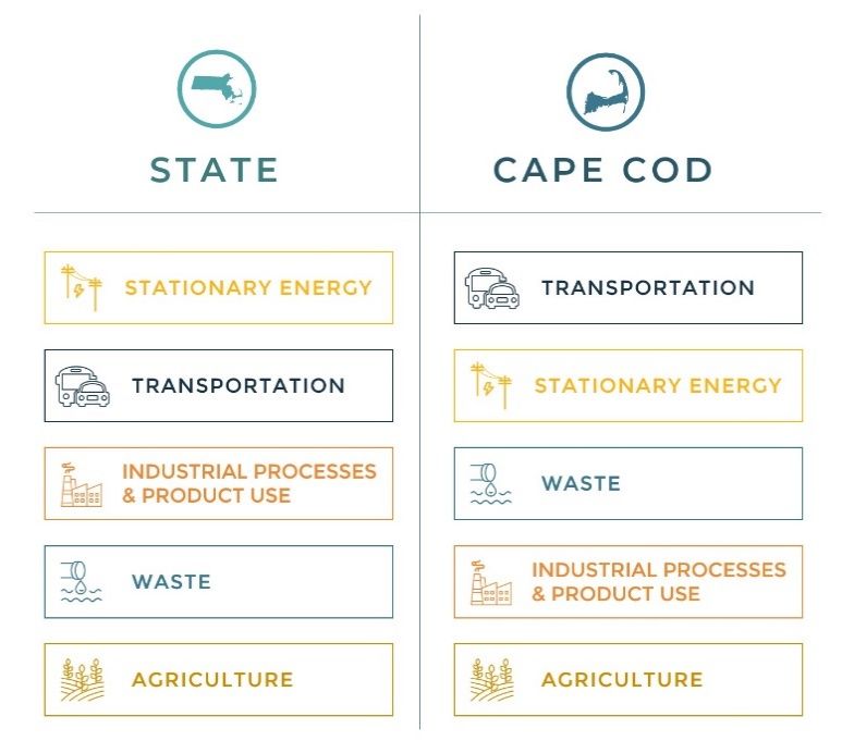
Summary of Findings
GHG emissions for Cape Cod in 2017 equal 3,564,875 MTCO2E, approximately 4-5% of
Massachusetts state emissions. The highest amount of emissions is associated with transportation,
equaling 55.5% of total Cape inventory emissions. The second highest amount of emissions are from
stationary energy use at 39% of total inventory emissions. The remaining 5% of emissions are
attributed to the waste (3%), industrial processes (2%), and agriculture (0.4%) sectors.
SECTOR EMISSIONS (MTCO 2 E)
Stationary Energy 1,398,549
Transportation 1,979,525
Industrial Processes and Product Use 66,093
Agriculture 15,152
Waste 105,556
Total Emissions 3,564,875
Emissions on Cape Cod differ from the state in that where transportation is the largest emissions
sector for the Cape, transportation is the second highest emissions sector for the state, behind
stationary energy use. Similarly, where the Cape has higher emissions from waste as a percentage of
| Page 5CAPE COD REGIONAL GREENHOUSE GAS INVENTORY
this inventory, the state has higher emissions from industrial processes followed by waste.
Agriculture in both inventories represent the lowest amount of total inventory emissions.
Where comparable emissions data
are available, the Cape is
proportionally comparable to the
state level emissions from electricity
use and residential fuel use (natural
gas, fuel oil, propane, and wood).
The Cape has higher emissions
relative to the state from on-road
transportation use, and slightly
higher emissions from solid waste
and agriculture. The Cape has lower
emissions than the state in
commercial fuel use (natural gas,
fuel oil, propane), aviation, industrial
processes, and wastewater
treatment and disposal.
Also calculated are the effects of land use and forestry on the region (represented by forestland,
grassland, and cropland), which has the potential to sequester 340,582 MTCO2E per year, equal to
9% of total inventory emissions. The largest potential for sequestration comes from forestland. This
percentage of sequestration is consistent with the sequestration from forestland calculated for the
state. Wetlands also contribute significantly to the carbon sequestration potential of the region.
However, with the lack of a consistent methodology at this time to estimate such potential, that
analysis should be considered for future inventories.
| Page 6CAPE COD REGIONAL GREENHOUSE GAS INVENTORY
Methodology
STATIONARY ENERGY
Introduction
The stationary energy sector includes emissions from residential, commercial, and industrial uses of
electricity, natural gas, fuel oil, propane, and wood (residential only). Combined, natural gas, fuel oil,
electricity, propane, and wood account for 99% of home heating on Cape Cod.
Electricity emissions represent indirect emissions from electricity generation, which uses a variety of
sources, including fossil fuels. According to ISO-New England “2017 ISO New England Electric
Generator Air Emissions Report”, 48% of the electricity produced by generators in New England that
year came from natural gas, while 31% came from nuclear power, and 8% came from hydropower,
totaling 87% of the electricity generated. The remaining electricity generation was from refuse, wind,
and wood (each approximately 3%), coal (2%), and solar, oil and landfill gas (each ≤1%).
In 2017, Barnstable County used 4% of the total electricity use of the state, making it the ninth
ranked county for electricity use (out of 14), above Berkshire, Hampshire, Franklin, Dukes, and
Nantucket counties. In Massachusetts, commercial/industrial uses account for 64% of electricity
usage, whereas in Barnstable County, residential electricity use is higher than commercial/industrial
use (56% and 44%, respectively). This makes Barnstable County one of four counties (Barnstable,
Dukes, Nantucket, and Plymouth) whose residential electricity use is higher than its
commercial/industrial electricity use.
Similarly, for natural gas use, Barnstable County used 4% of the total natural gas use of the state. Of
the 12 Massachusetts counties with available natural gas, Barnstable County also ranked ninth in
usage, followed by Berkshire, Hampshire, and Franklin counties. In Massachusetts, most natural gas
usage is also from the commercial/industrial sector (55%). Again, in Barnstable County, residential
natural gas usage is higher than commercial/industrial usage (69% and 31%, respectively).
Barnstable County is one of three counties (Barnstable, Essex, and Plymouth) whose residential
natural gas use is higher than its commercial/industrial natural gas use. Two counties have natural
gas usage split evenly between residential and commercial/industrial users.
According to the U.S. Census Bureau’s annual American Community Survey’s (ACS) 2017 5-year
estimate, there were 162,629 housing units in Barnstable County. Of those, 95,011 units (58%) were
identified as year-round, 61,563 units (38%) as seasonally vacant (seasonal, recreational, or
occasional use), and 6,055 units (4%) under one of several other categories of vacant. To more
properly account for greenhouse gas emissions from seasonal units, the Commission developed a
method to estimate consumption of non-metered fuels (home heating oil, propane) for these units.
| Page 7CAPE COD REGIONAL GREENHOUSE GAS INVENTORY
Data from the Commission’s 2017 Cape Cod Second Homeowners Survey was used to estimate days
of annual occupancy during the heating season. This methodology is described in the Fuel Oil
methods section.
In total, stationary energy equals approximately 39% of total County emissions (1,398,549 MTCO2E),
with the highest emissions coming from the Residential subsector (947,077 MTCO2E), followed by
the Commercial/Industrial subsector (452,400 MTCO2E). Natural gas use is the largest source of
residential energy emissions (393,463 MTCO2E), while commercial/industrial uses produce the most
emissions from electricity use (237,185 MTCO2E).
Residential
ELECTRICITY
Residential electricity usage data were obtained from MassSave 2 and are directly reported by the
utility provider. Emissions were calculated by multiplying the total residential usage for Barnstable
County in megawatt hours (MWh) by an annual average emissions factor calculated by ISO-New
England as reported in “2017 ISO New England Electric Generator Air Emissions Report” based on
that year’s mix of energy sources powering the electric grid.
NATURAL GAS
Residential natural gas usage data were obtained from MassSave 3 and are directly reported by the
utility provider. Emissions were calculated by multiplying the total reported residential usage for
Barnstable County by MassDEP’s emissions factor for natural gas. Emissions from natural gas
distribution system losses are included and were calculated based on the amount of natural gas
used multiplied by an IPCC emissions factor for distribution system losses.
FUEL OIL
Residential fuel oil use emissions were calculated based on the number of year-round occupied
homes using fuel oil as a household heating source reported in the ACS. Five-year average fuel
use for 2014-2018 was calculated using information from the Massachusetts Department of Energy
Resources 4 data on household heating costs. A 5-year average was used due to the variability in
year-specific data, which reflect yearly variations in winter temperatures. MassDEP emissions factors
for fuel oil were used for these calculations.
2
https://www.masssavedata.com/Public/GeographicSavings?view=C
3
Ibid.
4
https://www.mass.gov/info-details/household-heating-costs
| Page 8CAPE COD REGIONAL GREENHOUSE GAS INVENTORY
A separate methodology was used to calculate fuel oil and propane use for home heating in
seasonal and vacant homes, as detailed below. Electricity and natural gas use are reported directly
by the service providers and as such reflect actual usage data.
SEASONAL AND VACANT HOME FUEL USE
Cape Cod has a high percentage of seasonal homes (38%), which are not in use for most of the
winter months, when the greatest portion of home heating occurs; therefore, a method to more
accurately estimate the fuel oil and propane use contribution of seasonally-used homes is
appropriate. This method considers when during the year the seasonal homes are being used, for
how long, and what level of heating effort is needed during that time. This method was also applied
to homes categorized as vacant.
The 2017 ACS was used to determine the number of housing units in Barnstable County and their
vacancy status. Total units, occupied (year-round), vacant (all) and seasonally vacant (subset of all
vacant) are as follows:
TOTAL UNITS YEAR-ROUND VACANT-ALL VACANT-SEASONAL
162,629 95,011 67,618 61,563
The ACS was also used to estimate the type of heating fuel for seasonal units, which is only reported
for year-round units. This model assumes heating methods in seasonal units are at the
same percentages as fuels in year-round units.
HOUSE HEATING FUEL AS A PERCENT OF Timeframes
OCCUPIED HOMES
The U.S. Energy Information Administration
Utility Gas 58.85% (EIA) recognizes Winter as October 1 through
Fuel Oil 25.20% March 31. This model adds April to better align
Electricity 10.59% with local practices in the use of second
Liquid Propane 3.02% homes. May 1 through September 30 include
Wood 1.57% the busiest of the Cape’s “shoulder season”
Other 0.35% months, as indicated in the 2017 Cape
Coal 0.17% Cod Second Homeowners Survey.
No Fuel 0.15%
Solar 0.10%
| Page 9CAPE COD REGIONAL GREENHOUSE GAS INVENTORY
The 2017 Cape Cod Second Homeowners Survey 5 respondents indicated the following average
occupancy:
■ May-September (In-Season): 73 days (out of 153 total days, 48.2% occupancy)
■ October-April (Off-Season): 29 Days (out of 212 total days, 13.5% occupancy)
■ Total: 102 Days
Monthly Fuel Consumption
Unlike natural gas and electricity, home heating oil and propane usage lacks standardized monthly
reporting mechanisms at the local level. Three-year averages (2016-2018) of monthly natural gas use
in Barnstable County from MassSave were used to develop monthly percentages of fuel use. These
percentages were used as a proxy for level of heating effort for a given month and applied to
annualized home heating fuel oil and propane usage estimates.
PERCENT OF FUEL USE FOR THE YEAR:
■ October-April: 84%
■ May-September: 16%
MONTHLY FUEL CONSUMPTION AS A Numbers presented are rounded to the nearest whole
PERCENT OF TOTAL YEARLY USAGE number.
January 17%
February 14%
March 14%
April 9%
May 5%
June 3%
July 3%
August 3%
September 3%
October 5%
November 10%
December 17%
5
https://www.capecodcommission.org/resource-
library/file/?url=/dept/commission/team/Website_Resources/economicdevelopment/Report_Cape_Cod_Second_Homeowners_201
7_FINAL.pdf
| Page 10CAPE COD REGIONAL GREENHOUSE GAS INVENTORY
Calculating In-Season and Off-Season Average Daily Fuel Use
HEATING FUEL OIL
The 5-year average household heating fuel oil use for 2014-2018 from the Commonwealth of
Massachusetts 6 is 707 gallons.
This results in the following estimated fuel oil use for the specified periods:
■ October-April (Off-Season): 594 gallons (84% of yearly fuel oil use)
■ May-September (In-Season): 113 gallons (16% of yearly fuel oil use)
Based on the 5-year average estimate of 707 gallons of fuel oil use per year, the average daily usage
for each time period would be:
PERIOD GALLONS AVE/DAY
October-April (84%) 594 2.80 gal
May-September (16%) 113 0.74 gal
PROPANE
The 5-year average household heating propane use for 2014-2018 from the Commonwealth of
Massachusetts3 is 582 gallons.
This results in the following estimated propane use for the specified periods:
■ October-April (Off-Season): 489 gallons (84% of yearly propane use)
■ May-September (In-Season): 93 gallons (16% of yearly propane use)
Based on the 5-year average estimate of 582 gallons of propane use per year, the average daily
usage for each time period would be:
PERIOD GALLONS AVE/DAY
October-April (84%) 489 2.31 gal
May-September (16%) 93 0.61 gal
6
https://www.mass.gov/info-details/household-heating-costs
| Page 11CAPE COD REGIONAL GREENHOUSE GAS INVENTORY
OFF-SEASON LEVEL OF HEATING EFFORT
Average temperatures were calculated using monthly data for Barnstable County from the National
Oceanic and Atmospheric Administration’s (NOAA) National Centers for Environmental Information 7
for 2010-2019.
■ May-September (In-Season): 66.3 degrees
■ October-April (Off-Season): 41.3 degrees
Assuming a target heating temperature of 68 degrees when a home is occupied [based on
Environmental Protection Agency (EPA) recommended settings] and a target heating temperature of
50 degrees when a home is not occupied, in the off-season the temperature inside a home when it’s
being occupied would need to be raised 26.7 degrees above the average off-season temperature of
41.3 degrees to reach 68 degrees. Similarly, in the off-season the temperature inside of a home
when it is unoccupied would need to be raised 8.7 degrees to reach 50 degrees. Raising the
temperature 8.7 degrees when unoccupied represents 33% of the heating effort needed to raise the
temperature 26.7 degrees when occupied.
CALCULATION BASED ON OCCUPIED AND UNOCCUPIED DAYS
To calculate the seasonal fuel usages, the number of occupied days during in-season and off-season
were multiplied by their corresponding average daily use amounts for fuel oil usage. Unoccupied
daily usage was used at a rate of 33% of the occupied usage, based on the reduced level of heating
effort 8.
In-Season daily usage was calculated based on days used and the average daily usage for the May-
September period without any factors applied.
AVE DAYS IN GALLONS
GALLONS/DAY USE USED
Daily Use In-Season (May-September) 0.74 74 54.47
Off-Season Occupied Consumption at 68 Degrees 2.80 29 80.28
Off-Season Unoccupied Consumption at 50 Degrees 0.91 183 167.35
Annual 302.11
302.11/707 gallons = 0.43 (seasonal homes use 43% of the fuel of a year-round home, on average)
7
NOAA National Centers for Environmental Information, Climate at a Glance: County Time Series, published June 2020.
https://www.ncdc.noaa.gov/cag/county/time-series/MA-001/tavg/all/10/2010-2020
8
The effects of heat transfer differences for higher or lower degree days, unit size or other unit characteristics were not calculated.
| Page 12CAPE COD REGIONAL GREENHOUSE GAS INVENTORY
Using this method, 43% of the average year-round use of fuel oil and propane was used to calculate
emissions from seasonal and vacant homes, equal to 302.11 gallons for fuel oil and 250.26 gallons
for propane.
PROPANE
Emissions from propane use were calculated based on the number of occupied homes using
propane as a household heating source as reported in the ACS. Five-year average propane use for
2014-2018 was calculated using information from the Massachusetts Department of Energy
Resources data on household heating costs. A 5-year average was used due to the variability in year-
specific data, which reflect yearly variations in winter temperatures. MassDEP emissions factors
for propane were used for these calculations.
To calculate propane use in seasonal and vacant homes the same methodology was used as in
calculating seasonal/vacant fuel oil use.
WOOD
Emissions from the use of wood were apportioned from the state reported emissions from wood
use for 2017 (0.8 MMTCO2E, or 800,000 MTCO2E) based on the number of Cape Cod homes using
wood as a household heating source compared to the state, as identified in the ACS.
RESULTS
The largest amount of residential stationary energy emissions is from natural gas use, followed by
electricity use. These energy sources can be used to power multiple components of residential
buildings (heating sources and appliances), while emissions calculated for fuel oil, propane and
wood are only associated with home heating.
SUBSECTOR EMISSIONS (MTCO 2 E)
Electricity 297,280
Natural Gas 393,464
Fuel Oil Total Emissions 222,809
Residential (Occupied) 170,844
Residential (Seasonal/Vacant) 51,966
Propane Total Emissions 12,596
Residential (Occupied) 9,642
Residential (Seasonal/Vacant) 2,954
Wood 20,000
Total 946,149
| Page 13CAPE COD REGIONAL GREENHOUSE GAS INVENTORY
Commercial/Industrial
ELECTRICITY
Commercial/industrial electricity usage data were obtained from MassSave and are directly
reported by the utility provider. Electricity emissions were calculated by multiplying
commercial/industrial reported usage in megawatt hours (MWh) by an annual emissions factor
calculated by ISO-New England based on that year’s mix of energy sources powering the electric
grid.
NATURAL GAS
Natural gas usage data for commercial/industrial uses were obtained from MassSave and are
directly reported by the utility provider. Emissions were calculated by multiplying
commercial/industrial reported usage in therms 9 by the state’s emissions factor for natural gas.
Emissions from natural gas distribution system losses are included and were calculated based on
the amount of natural gas used multiplied by an IPCC emissions factor for distribution system
losses.
FUEL OIL
Commercial/industrial fuel oil use was estimated using data on the sectors’ statewide use and the
relative statewide portion of commercial/industrial buildings square footage on Cape Cod. Total
state commercial/industrial fuel oil use was averaged over a 5-year period (2014-2018) using data
from the U.S. Energy Information Administration 10. The relative statewide portion of Cape Cod
commercial/industrial building square footage was calculated using the Metropolitan Area Planning
Council’s Land Parcel Database 11. This number was used to estimate the amount of fuel oil use as a
portion of the state-reported total. MassDEP emissions factors were used to calculate emissions on
the Cape’s estimated portion of fuel oil use.
PROPANE
Commercial/industrial propane use was estimated using data on the sectors’ statewide use and the
relative statewide portion of commercial/industrial buildings square footage on Cape Cod. Total
state commercial/industrial propane use was averaged over a 5-year period (2014-2018) using data
from the U.S. Energy Information Administration. The relative statewide portion of Cape Cod
commercial/industrial building square footage was calculated using the Metropolitan Area Planning
Council’s Land Parcel Database. This number was used to estimate the amount of propane use as a
9
A therm is a unit of heat equal to 100,000 British thermal units (Btus).
10
https://www.eia.gov/state/seds/seds-data-complete.php?sid=MA
11
https://datacommon.mapc.org/
| Page 14CAPE COD REGIONAL GREENHOUSE GAS INVENTORY
portion of the state-reported total. MassDEP emissions factors were used to calculate emissions on
the Cape’s estimated portion of propane use.
The Commission also collected data on propane and diesel fuel use from certain commands at Joint
Base Cape Cod. Emissions were calculated for CO2, CH4, and N2O by multiplying the amount of fuel
used by a specific emissions factor for each fuel type and gas. MassDEP emissions factors were used
for each type of fuel.
RESULTS
The highest amount of emissions in the commercial/industrial subsector comes from electricity use,
followed by natural gas use.
SUBSECTOR EMISSIONS (MTCO 2 E)
Electricity 237,185
Natural Gas 174,181
Fuel Oil 32,812
Propane 6,039
Fuel Use at JBCC 2,183
Total 452,400
| Page 15CAPE COD REGIONAL GREENHOUSE GAS INVENTORY
TRANSPORTATION
Introduction
The transportation sector on Cape Cod accounts for 55.5% of the total Greenhouse Gas (GHG)
emissions for the region. The GHG analysis captures mobile emissions from on-road and off-road
vehicle use and various forms of transportation, including ferry, aviation, transit, and rail. The
majority of transportation-related emissions (78%) are attributed to on-road vehicles, which is based
on the annual vehicle miles traveled (VMT) within the region. In total, emissions from the
transportation sector equate to 1.979 million MTCO2E (MMTCO2E).
On-Road Vehicles
Based on 2017 Massachusetts Registry of Motor Vehicles (RMV) data, there are approximately
224,575 registered vehicles in Barnstable County, which include passenger cars, SUVs, motorcycles,
buses, and light and heavy-duty trucks. Of the 224,575 registered vehicles, there are approximately
160 12 electric vehicles in Barnstable County. For the on-road vehicle emissions calculation, the
Commission referenced the annual average Vehicle Miles Travelled (VMT) estimate for Barnstable
County, which was obtained from the regional travel demand model prepared by the Central
Transportation Planning Staff (CTPS) of the Boston Metropolitan Planning Organization (MPO).
Additionally, fuel economy estimates were referenced from the U.S. Department of Energy’s
Alternative Fuels Data Center (March 2020) as part of the on-road vehicle fuel usage calculation. To
account for the zero tailpipe emissions associated with electric vehicles within the County, the total
number of passenger cars was reduced by the total number of electric vehicles prior to emission
calculations. Note that emissions associated with electric vehicle charging would be captured under
stationary energy use.
The following calculation was used to determine the amount of fuel use for each RMV vehicle type
recorded in Barnstable County.
Vehicle Fuel Use = VMT * RMV vehicle type %
Average miles per gallon
Emissions were calculated for CO2, CH4, and N2O by multiplying the amount of fuel used for each
vehicle type by a specific emissions factor for each fuel type and greenhouse gas. The emission
12
Based on cumulative MOR-EV rebates (https://mor-ev.org/program-statistics) Note: In 2020, data on the number of registered
EVs by county and town became available from the Massachusetts Registry of Motor Vehicle (RMV). As of May 2020, the RMV
reported 1,256 EVs registered in Barnstable County. RMV data on registered EVs is anticipated to be used in future greenhouse
gas analyses.
| Page 16CAPE COD REGIONAL GREENHOUSE GAS INVENTORY
factors (EF) for the on-road vehicle emission calculations were referenced from the IPCC 2006
mobile combustion guidelines for gasoline and diesel vehicles (Volume 2, Chapter 3).
RESULTS
On-road vehicles contribute 1.55 MMTCO2E, with passenger cars/SUVs as the largest contributor,
accounting for 64% of on-road emissions. Light-duty trucks account for 22% of on-road emissions,
heavy-duty trucks account for 12% of emissions, and motorcycles account for the remaining 1% of
emissions.
SUBSECTOR EMISSIONS (MTCO 2 E)
Passenger Cars 991,271
Light-duty Trucks 348,199
Heavy-duty Trucks 193,095
Motorcycles 17,206
Total 1,549,771
Public Transportation
The public transportation subsector includes both transit and ferry service. The transit providers
within the region consists of regional and local service provided by the Cape Cod Regional Transit
Authority (CCRTA) and inter-city transit service to the region from Boston provided by Plymouth &
Brockton Street Railway Co. (P&B) and Peter Pan Bus Lines. Additionally, the transit emissions
analysis includes service provided by the Mashpee Wampanoag Tribe vans and the Steamship
Authority buses. This analysis presents emissions from round-trip service, not just the portion of
service within Barnstable County. These transit services are captured in the on-road subsector
within the VMT model, and as such represents a portion of the on-road emissions. Therefore, these
emissions have not been added to the overall total for transportation emissions.
Passenger ferry service within the region is provided by a range of seasonal and year-round
operators and routes further discussed below. The Steamship Authority (SSA) is the only ferry
operator in Barnstable County that carries both passengers and vehicles, including commercial
freight, to and from Cape Cod and the islands of Nantucket and Martha’s Vineyard. For purposes of
this analysis, a passenger ferry generally includes ferry service to and from Cape Cod to the islands
of Martha’s Vineyard and Nantucket as well as the ferries to and from Boston to Provincetown.
Emissions from passenger ferry service are included in the total emissions from the transportation
sector.
TRANSIT
Transportation emissions associated with transit service in Barnstable County were based off 2017
fuel usage data. Fuel usage data for the CCRTA, SSA buses, and the Mashpee Wampanoag Tribe vans
| Page 17CAPE COD REGIONAL GREENHOUSE GAS INVENTORY
were based on 2017 data provided by the National Transit database (NTD). 13 NTD fuel usage records
for P&B were only available for 2015 as they stopped reporting to the NTD in 2016. Based on a
comparison review of bus schedules in 2015 and 2017, it appears that there were additional service
stops in 2017 for P&B that may have increased transit emissions slightly and are not included in this
analysis. Fuel usage data was not available for Peter Pan Bus Lines and therefore was estimated
based on a review of their 2017 bus schedule to calculate an estimate of their annual VMT. Based on
a comparison review of P&B data within the NTD, an average fuel economy for a coach bus of 4
miles per gallon (mpg) was used to estimate fuel usage for Peter Pan buses.
Emissions were calculated for CO2, CH4, and N2O by multiplying the amount of fuel used for each
transit provider by a specific emissions factor for each fuel type and gas. The emission factors (EF)
for the on-road transportation emission calculations were from the IPCC 2006 mobile combustion
guidelines for gasoline and diesel vehicles (Volume 2, Chapter 3).
Transit Results
Transit service within, and to and from, Barnstable County contributes emissions of approximately
10,720 MTCO2E. Transit emissions account for approximately 1% of the overall transportation sector
emissions.
SUBSECTOR EMISSIONS (MTCO 2 E)
Transit 10,720
Total 10,720
FERRY
Fuel usage data was requested from the major passenger ferry service providers in Barnstable
County. The SSA reports their annual fuel usage to the NTD, which was obtained for the 2017
baseline analysis. Data requests for fuel usage figures from 2017 were also provided by Hy-Line
Cruises and Bay State Cruises for their ferry services out of Hyannis and Provincetown, respectively.
It should be noted that the fuel usage data provided by Hy-Line Cruises may also be related to their
scenic tour operations in addition to their regular passenger ferry operations.
To account for other smaller ferry operators within the region, estimates for annual VMT were
calculated based on review of the route mileage and operating schedules found online. The analysis
also accounts for the following smaller ferry operators: Boston Harbor Cruises, Island Queen, Pied
Piper, Freedom Ferry and the Vineyard Shuttle operated by Patriot Party Boats, Inc. An estimate of
average ferry boat fuel consumption was calculated based on a review of the 2017 NTD Energy and
13
https://www.transit.dot.gov/ntd/ntd-data
| Page 18CAPE COD REGIONAL GREENHOUSE GAS INVENTORY
Route data for all NTD reporting ferry operators. Based on our review of ferry operators in the U.S.,
a passenger ferry averages approximately 0.51 miles per gallon (mpg) of fuel. This fuel consumption
estimate was applied to the VMT analysis for the small ferry operators where fuel use data was
unavailable.
Emissions were calculated for CO2, CH4, and N2O by multiplying the amount of fuel used for the ferry
operators by a specific emissions factor for each fuel type and gas. The emission factors (EF) for the
waterborne navigation emission calculations were from the IPCC 2006 mobile combustion
guidelines for gasoline and diesel fuel (Volume 2, Chapter 3).
Ferry Results
Ferry operations within, and to and from, Barnstable County emit approximately 49,441 MTCO2E.
Emissions associated with ferry operations account for approximately 2% of the emissions within
the overall transportation sector. Within the subsector of Public Transportation, emissions from
ferry operations account for over 80% of total emissions while transit accounts for approximately
20%.
SUBSECTOR EMISSIONS (MTCO 2 E)
Ferry 49,441
Total 49,441
PUBLIC TRANSPORTATION RESULTS
Combined, public transportation (ferry and transit service) accounts for a total emission of 61,161
MTCO2E within Barnstable County and equates to 3% of the total emissions from the transportation
sector and 0.7% of on-road emissions (excluding ferries).
Off-Road
The off-road subsector estimates emissions for non-highway vehicles and equipment. Categories in
this subsector include:
■ agricultural equipment (ex. tractors, balers, and other cultivation equipment);
■ aviation ground support (ex. baggage tractors and cargo loaders);
■ commercial and industrial equipment and trucks (ex. forklifts and tractors);
■ construction equipment and trucks (ex. back hoes, cranes, and drill rigs);
■ commercial and private lawn and garden equipment (ex. chainsaws, mowers, leaf and snow
blowers);
■ pleasure craft (ex. recreational boating and personal watercraft);
| Page 19CAPE COD REGIONAL GREENHOUSE GAS INVENTORY
■ off-road recreational vehicles (ex. all-terrain vehicles and golf carts); and,
■ Fuel use and sales and jet fuel use on Joint Base Cape Cod.
Data for all off-road categories, except Joint Base Cape Cod, were obtained from the Metropolitan
Area Planning Council’s (MAPC) DataCommon. MAPC used the Environmental Protection Agency’s
(EPA) MOVES2014b NONROAD Model to estimate CO2 and CH4 emissions from those categories.
This tool was developed by the EPA to assist states with air quality modeling and to predict
emissions from non-road engines based on estimates of equipment populations and fuel
consumption. To supplement these data, MAPC incorporated Federal Highway Administration
(FHWA) data on construction, commercial, and industrial truck non-highway gasoline consumption.
Together, the EPA model and FHWA data use information from a combination of state reporting
programs, engine production and manufacturing sales, federal surveys, private research firms,
industry organizations, and modeling.
In addition to the EPA model run by MAPC, the Commission collected data on vehicle fuel use and
sales and jet fuel use from certain commands at Joint Base Cape Cod (JBCC). Emissions were
calculated for CO2, CH4, and N2O by multiplying the amount of fuel used by a specific emissions
factor for each fuel type and gas. The emissions factors used for each type of fuel are from the IPCC
2006 mobile combustion guidelines for on-road gasoline and diesel vehicles (Volume 2, Chapter 3)
and MassDEP emissions factors for jet fuel.
RESULTS
The largest amount of off-road emissions is attributed to the commercial and industrial categories,
followed by pleasure craft, the construction category, and lawn and garden equipment.
SUBSECTOR EMISSIONS (MTCO 2 E)
Agricultural Equipment 158
Aviation Ground Support 299
Commercial/Industrial Equipment and Trucks 146,725
Construction Equipment and Trucks 64,366
Lawn and Garden Equipment 61,464
Pleasure Craft 72,846
Recreational Vehicles 6,617
Fuel Use at JBCC 7,305
Total 359,781
| Page 20CAPE COD REGIONAL GREENHOUSE GAS INVENTORY
Aviation
Emissions associated with aviation activities (commercial and recreational) for the region are
attributed to the three municipally owned airports: Barnstable, Chatham, and Provincetown. The
analysis also includes aviation activities associated with the Coast Guard operations on Joint Base
Cape Cod. There are additional recreational aviation activities that occur within the region at two
local airfields; Marstons Mills and Falmouth, however, fuel usage data from these local airfields was
not obtained as part of this inventory and would likely be a small contributor to the overall
emissions from the aviation subsector. Fuel usage data for both jet fuel and aviation gas sales in
2017 were provided from the operators of the three commercial airports and the Coast Guard for
our analysis purposes. Similar to public transportation, these emissions represent flights to and
from Barnstable County.
Emissions were calculated for CO2, CH4, and N2O by multiplying the amount of type of aviation fuel
used by a specific emissions factor for each fuel type and greenhouse gas. The emission factors (EF)
for the aviation gasoline emission calculations were referenced from the IPCC 2006 mobile
combustion guidelines for aviation gasoline fuel (Volume 2, Chapter 3). The emissions factors for the
jet fuel calculations were referenced from the U.S. Energy Information Administration (EIA) guides
for jet fuel.
RESULTS
Aviation to and from Barnstable County attributes to an emission of approximately 19,614 MTCO2E
and accounts for approximately one percent of the emissions within the overall transportation
sector.
SUBSECTOR EMISSIONS (MTCO 2 E)
Aviation 19,614
Total 19,614
Rail
Within Barnstable County are two active rail lines and three rail operators. The Upper Cape rail line
connects to the Upper Cape Regional Transfer Station on Joint Base Cape Cod in Falmouth. The Mid
Cape rail line connects to the Yarmouth-Barnstable Regional Transfer Station with a rail spur line
connecting to Hyannis. Mass Coastal provides rail service for the two truck-to-rail trash transfer
facilities on Cape Cod to the Covanta SEMASS waste-to-energy plant in Wareham, Massachusetts.
Cape Cod Central Railroad operates scenic rail tours out of the Hyannis Transportation Center.
Additionally, the Massachusetts Bay Transit Authority (MBTA) provides seasonal passenger rail
service to and from Boston and Hyannis during the summer peak period on Friday evenings,
Saturdays, and Sundays from the end of June to Labor Day. Fuel usage data for all rail operations
| Page 21CAPE COD REGIONAL GREENHOUSE GAS INVENTORY
within, and to and from, Barnstable County were provided by the rail operators to calculate the
emissions associated with railroad operations. Similar to public transportation and aviation, these
emissions represent service to and from Barnstable County.
Emissions were calculated for CO2, CH4, and N2O by multiplying the amount of fuel used by a specific
emissions factor for the fuel type and each greenhouse gas. The emission factors (EF) for the
railroad emission calculations were referenced from the IPCC 2006 mobile combustion guidelines
for railroad diesel fuel (Volume 2, Chapter 3).
RESULTS
Railway operations within, and to and from, Barnstable County attributes to an emission of
approximately 918 MTCO2E and accounts for less than one percent of the emissions within the
overall transportation sector.
SUBSECTOR EMISSIONS (MTCO 2 E)
Rail 918
Total 918
| Page 22CAPE COD REGIONAL GREENHOUSE GAS INVENTORY
INDUSTRIAL PROCESSES AND PRODUCT USE
Introduction
The Commission defined the Industrial Processes and Product Use sector as those facilities that
report GHG emissions to the state GHG Reporting Program, and emissions of sulfur hexafluoride
(SF6) associated with electricity system transmission and distribution.
The state GHG Reporting Program requirements (310 CMR 7.71) were established pursuant to the
Massachusetts Global Warming Solutions Act of 2008 which required the reporting and verification
of state GHG emissions from, in part, facilities emitting more than 5,000 tons of CO2E per year. In
2015, the most recent MassDEP GHG Reporting Program Summary Report and Facility List available
on the Program’s website, there were 296 reporting facilities.
SF6 is an insulator in gas-insulated switchgear equipment used in large, high-voltage electricity
generation, transmission, and distribution equipment. Emissions of this gas from equipment can
occur at each phase of the equipment lifecycle, such as equipment manufacturing, installation, use,
servicing, and disposal.
Emissions from this sector total 66,092 MTCO2E; where GHG Reporting Program facilities equal
63,668 MTCO2E, and emissions of SF6 from electricity transmission and distribution equal 2,424
MTCO2E. This represents 2% of total inventory emissions.
Massachusetts GHG Reporting Program Facilities
Emissions associated with industrial processes and/or product use at facilities on Cape Cod were
obtained from the Massachusetts GHG Reporting Program for 2017. Four such facilities were
identified as reporting to the program that year: Cape Cod Hospital, Woods Hole Oceanographic
Institution (WHOI), Canal Generating Plant, and the Bourne Integrated Solid Waste Management
Facility. Emissions associated with the Bourne solid waste facility are reported in the Waste sector.
RESULTS
SUBSECTOR EMISSIONS (MTCO 2 E)
Cape Cod Hospital 6,610
WHOI 3,718
Canal Generating Plant 53,341
Total 63,668
| Page 23CAPE COD REGIONAL GREENHOUSE GAS INVENTORY
Electricity System Transmission and Distribution Losses
Emissions from electricity system transmission and distribution losses of SF6 were calculated by
apportioning the state reported emissions of SF6 for 2017 (60,610 MTCO2E) based on the portion of
electricity consumption in Barnstable County versus the state.
RESULTS
SUBSECTOR EMISSIONS (MTCO 2 E)
Electricity Losses 2,424
Total 2,424
| Page 24CAPE COD REGIONAL GREENHOUSE GAS INVENTORY
AGRICULTURE
Introduction
According to the 2017 U.S. Department of Agriculture (USDA) Census of Agriculture for
Massachusetts, Barnstable County has 4.4% of the total number of farms 14 in Massachusetts, and
6,564 acres of land in farms, equal to 1% of the total 491,653 acres of farmland in the state. The
average estimated market value per acre of farmland and associated buildings in Barnstable County
is $30,555, higher than the state average of $10,894, making Barnstable County the third highest
county in the state for average estimated market value per acre behind Suffolk and Nantucket
counties, respectively.
This sector includes emissions from livestock digestion (both enteric fermentation and manure
management) and soil management, including synthetic and organic fertilizer, and lime use. The
application of fertilizers that include nitrogen can enhance nitrification and denitrification rates,
increasing the production of N2O (direct emissions). Emissions also occur from the volatilization and
deposition of nitrogen gases (indirect emissions). Chemical processes also lead to a loss of CO2 from
the application of nitrogen fertilizers, and similarly, carbonates in lime undergo a series of chemical
processes which can release CO2.
Emissions associated with the biomass (vegetative) growth of cropland are considered in the Land
Use and Forestry sector.
Agriculture sector emissions equal 15,153 MTCO2E, 0.4% of total inventory emissions. Livestock and
soil management emissions equal 2,769 MTCO2E and 12,384 MTCO2E, respectfully.
Livestock
Using data on the number of livestock from the 2017 USDA Census of Agriculture 15, methane
emissions from enteric fermentation and manure management were both calculated by multiplying
the number of livestock by type by an emissions factor specific to each animal for the following
livestock that have an IPCC emissions factor: cows, sheep, goats, horses, mules, swine, poultry, and
alpaca. Barnstable County reportedly has 3,603 of these types of livestock, with the large majority of
those being birds categorized as poultry.
Direct and indirect N2O emissions for manure management were calculated using the number of
each type of livestock multiplied by standard nitrogen excretion rates and an emissions factor for
each type of animal. Direct N2O emissions occur from nitrification and denitrification of nitrogen.
14
A farm is defined by the USDA as any place where ≥ $1,000 in agriculture product is produced and sold.
15
https://www.nass.usda.gov/Publications/AgCensus/2017/Full_Report/Census_by_State/Massachusetts/index.php
| Page 25You can also read