Swartland Municipality - Swartland Draft South Area Plan - AREA PLAN FOR 2018/2019 - MAY 2018
←
→
Page content transcription
If your browser does not render page correctly, please read the page content below
Swartland Municipality
Swartland Draft South Area Plan
  Abbotsdale, Kalbaskraal, Chatsworth and Riverlands
                   WARDS 4 and 7

    AREA PLAN FOR 2018/2019 - MAY 2018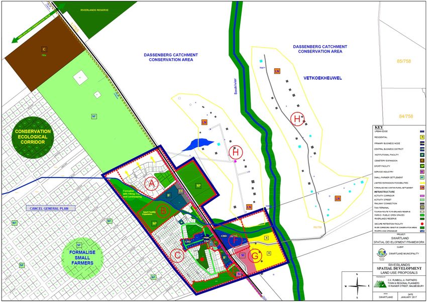
Contents
1     INTRODUCTION
      1.1 General
      1.2 Structure of document
      1.3 Compilation of the area plans
      1.4 The IDP and area plans
2     DEMOGRAPHIC SUMMARY OF THE SWARTLAND MUNICIPAL AREA
3     TOWNS IN THE AREA
3.1 Riverlands & Chatsworth
      (a) Historical background
      (b) Development perspective
      (c) Service backlogs
3.2. Kalbaskraal & Abbotsdale
      (a) Historical background
      (b) Development perspective
      (c) Service backlogs
3.3. Provincial Government investment in the area
3.4 Town statistics
4     WARD DETAIL
4.1 Ward 4 (Chatsworth, Riverlands, Mount Royal (Malmesbury), Ruststasie and rural areas)
      (a) Ward 4 description
      (b) Ward 4 committee information
      (c) Ward 4 statistics
      (d) Ward 4 priority needs
4.2 Ward 7 (Abbotsdale, Kalbaskraal and rural areas)
      (a) Ward 7 description
      (b) Ward 7 committee information
      (c) Ward 7 statistics
      (d) Ward 7 priority needs
5. MUNICIPAL BUDGET 2018/2019
ANNEXURE1: SPATIAL DEVELOPMENT FRAMEWORK PROPOSALS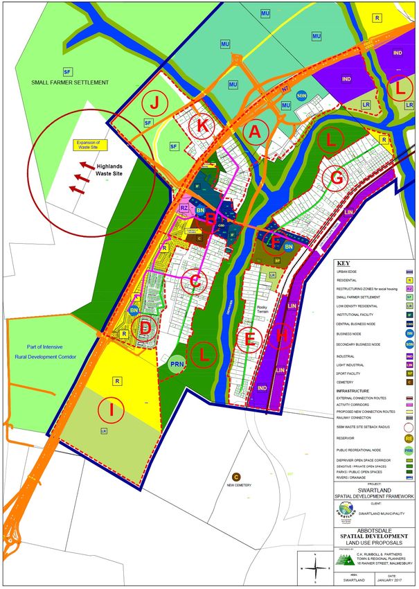
1 INTRODUCTION 1.1 GENERAL Area-based planning is an initiative that complements the IDP process by focusing and zooming in on communities. Communities in this sense are represented by settlements and wards. Because wards are often demarcated in a way that divides areas that in reality function as a unit, Swartland decided to adopt an approach that in the first place focuses on sensible geographical areas, simultaneously considering ward planning so that wards are not neglected. To achieve this, a number of wards are combined for each area plan. The following five planning areas were identified: North: Moorreesburg, Koringberg and Ruststasie (Wards 1 and 2) East: Riebeek West, Riebeek Kasteel and Ongegund (Wards 3 and 12) West: Darling and Yzerfontein (Wards 5 and 6) South: Abbotsdale, Chatsworth, Riverlands and Kalbaskraal (Wards 4 and 7) Central: Malmesbury (Wards 8, 9, 10 and 11 and small portions of wards 4, 7 and 12). As such, it is an approach that represents an effort to address integrated development planning at a sub-municipal level. There are therefore five planning areas; each with its own Area Plan document. Four of the five plans represent two wards each, while Malmesbury town represents four wards. The importance of the role of the wards and ward committees is addressed in the second section of each Area Plan. It also contains the community inputs and the results of the public meetings pertaining to those wards. 1.2 STRUCTURE OF DOCUMENT When presenting planning and community participation at local level, information is presented per town and per ward (as mentioned in the previous paragraph). This can be challenging as it interrupts the natural flow from analysis and community participation towards projects. To maintain clarity, however, everything that can be linked to a town was grouped in the town section, and everything linked to a ward approach, is presented in the ward section. 1.3 COMPILATION OF THE AREA PLANS The Municipality together with the ward committees commenced with the compilation of area plans covering all 12 wards. Meetings were held with all 12 ward committees to determine their issues and top ten priorities. The meetings were held on the following dates: 22 February 2018 – Ward 12 26 February 2018 – Wards 1, 2, 8 and 10 27 February 2018 – Wards 5, 6, 9 and 11 28 February 2018 – Ward 3 01 March 2018 – Wards 4 and 7
The role of the wards and ward committees is built into the process, as the second section of each area plan represents the ward committee members and the planning they have been involved with. During the meetings the persons present were given the opportunity to identify the main priorities of the relevant wards, in respect of the five IDP strategic goals. The priorities that were identified during the meetings were returned to the various ward committees by the end of March 2018 to verify the ten main priorities, as stated in the area plan. The area plan was finalized end of May 2018 and submitted to the council for approval. 1.4 THE IDP AND AREA PLANS The five area plans include the following: an understanding of social diversity in the community, the assets, vulnerabilities and preferences of these different social groups; an analysis of the services available to these groups, as well as the strengths, weaknesses, opportunities and threats facing the community; a consensus on priorities for the relevant wards; and Identification of projects for the IDP. Area plans help to ensure that the IDP is more targeted and relevant to addressing the priorities of all groups, including the most vulnerable. Area plans provide ward committees with a systematic planning and implementation tool to perform their roles and responsibilities. They form the basis for dialogue between the Municipality and ward committees regarding the identification of priorities and budget requests and will also be used by ward committees for ongoing monitoring and evaluation throughout the year. Area plans are part and parcel of the IDP and contain information used in defining the Municipality’s long term strategy. The information is however on a detail level and not duplicated in the IDP.
2      DEMOGRAPHIC SUMMARY OF THE SWARTLAND MUNICIPAL AREA
Total municipal area                                                         Demographics in 2016 (Stats SA 2016 Community Survey)
                                                                                    Population:     Younger than 34:                Households:
    3 700 km²
                                                                                    133 762         61%                             39 139

Education in 2016 (2017 Socio-economic profile, PGWC)

          Learner-teacher ratio: 42.5      Gr12 dropout rate: 23.2%    Matric pass rate: 89.4%     Number of schools: 31 Schools with libraries: 17

Poverty in 2016 (2017 Socio-economic profile, PGWC)

          Gini Coefficient: 0.58       Human Development Index: 0.69        Households with no income: 10.4%          Indigent households: 8 495

Access to basic services in 2016 (Stats SA, 2016 Community Survey, minimum service level)

          Piped water: 92.8%                        Refuse removal: 83.5%            Electricity: 98.7%                 Sanitation: 96.2%

Economy [Municipal Economic Review and Outlook (MERO), 2017]                 Employment (2017 Socio-economic profile, PGWC)

                 Average annual GDP growth 2005-2015: 3.4%                            Average annual employment growth 2005-2015: 1.6%

Three largest sectors according to GDPR contribution in 2015 (2017 Socio-economic profile, PGWC)
Manufacturing: 24.4%             Wholesale and retail trade, catering and accommodation: 17.5% Agriculture, forestry and fishing: 14.4%

Health in 2016 (2017 Socio-economic profile, PGWC)
                Number of primary                                     Maternal deaths per      Registered patients       % babies born to mothers
                                           Immunisation rate: 85.1%
                health care facilities: 14                            100 000 live births: 0   receiving ART: 2 086      under 18: 9.3%

Safety and security – % change between 2016 and 2017 in number of reported cases (2017 Socio-economic profile, PGWC)
                                       Driving under the influence:
          Residential burglaries: 1.2%                              Drug-related crime: 49.0% Murders: -26.8% Sexual offences: -1.7%
                                       67.0%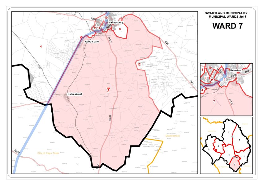
3     TOWNS IN THE AREA
3.1   RIVERLANDS AND CHATSWORTH

(a)   HISTORICAL BACKGROUND
Riverlands
During the early nineteenth century the Methodist Episcopolian Church purchased a farm named Micheal Heynskraal and established a town. Buyers
from near and far obtained erven here. Services and infrastructure which were promised to buyers were never installed and lead to large scale of
dissatisfaction.
The “town: Riverlands (as it would have been named, although the registered name was Chatsworth) as a result of this, never developed. A portion of
the area was purchased by the Department of Nature Conservation; Cape Provincial Administration from SA Transport Services, seeing that is was
considered an ecological sensitive area. Riverlands Nature reserve was established on this area.
Currently there are two towns approximately 3km’s from each other within the area known as Greater Chatsworth. The towns are known as
Chatsworth and Riverlands, both areas are classified as settlements in terms of the Spatial Planning Category.
Chatsworth
Chatsworth originated around the existing church dating back to 1900 with a school that followed in 1906. The church and school are still the focus
point of the town. Chatsworth was initially bought by a private developer who at a later stage sold erven to individuals. The majority if the erven in
Chatsworth are privately owned.
Riverlands originated in the early 1900’s around the DR Missionary Church and the school, on the land that was purchased by Spoornet. Riverlands’
name is suitable because the town is bisected by a water course which flows into the Swartriver. The town is reasonably isolated with limited services
and a great need in terms of poor circumstances of living conditions, which can be attributed to a high population growth, unemployment and other
poverty related circumstances.

(b)   DEVELOPMENT PERSPECTIVE
Riverlands
During the late 1900’s the railways obtained an area next to Chatsworth to build a school and church for the informal residents. Riverlands was formed
to serve as a water service point for passing trains. Riverlands forms part of the West Coast Biosphere as proclaimed by UNESCO in 2000 to acclaim not
only the inherent quality of the West Coast’s beauty, but also the local community approach to life.
Chatsworth
During the early 19th century, an American church obtained the form Michiel Heynskraal and subsequently a town was established on it. Buyers from
all over purchased erven, but the services and infrastructure that were promised never realized. Subsequently the town was never officially
established. The name was registered as Chatsworth although the community wanted to call it Riverlands.
Preparations for the building of the Morris Brown Chapel started in 1890 on a portion of land that was donated by Mr Isak Arendse. The church formed
a great pillar of support for the whole community of Chatsworth. In 1906, a school for grades 1-8 was started at the church.
(c) SERVICE BACKLOGS Sewerage Sewerage systems must be extended. Waste Water Treatment Works must be upgraded. Storm water Formal system is limited to housing projects and 5th Avenue Chatsworth. Regular flodding of residences and erven. Upgrading of storm water infrastructure in Chatsworth. Water Secondary Chlorination at reservoirs must be implemented. Shortfall in reservoir storage capacity; new reservoir must be constructed. Bulk supply system cannot supply in the demand during peak months. Water supply is under pressure due to illegal conncetions and wastage of water. Streets Gravel roads needs to be upgraded. Construction of a bus route in Chatsworth Electricity Eskom area of supply. 3.2 KALBASKRAAL AND ABBOTSDALE (a) HISTORICAL BACKGROUND Kalbaskraal Kalbaskraal was established in 1898 on the farm Spes Bona as a result of a railway crossing between Cape Town, Darling and Malmesbury. Kalbaskraal is a small village with an unstructured, rural appearance and a population of about 100 people. Abbotsdale Abbotsdale is located south-west of Malmesbury on the banks of the Diep River. This small residential rural town was developed on the farm Olyphantsfontein which was bought in 1865 by Bishop Gray for the purpose of erecting a mission for the Church of the Province of SA. The town owes its name to a certain Mr. Abbot who was affiliated to the omnibus of Cape Town. Currently there are more than 2000 inhabitants who find their employment mainly in Malmesbury, Atlantis and the Cape Metropole. (b) DEVELOPMENT PERSPECTIVE Since the reduction of rail transport, economic development has stagnated in the settlement, with consequent unemployment and poverty problems. The town has virtually no intrinsic economic base and very little growth potential on its own merit. Because of its location clos to Durbanville, it functions
as a residential/dormitory town for the Metropole rather that for the Swartland region. Many of the residents work in Cape Town or Atlantis and
commute on a daily basis from Kalbaskraal.
Because of its Metropolitan interaction the economic sector of the working residents, transport and market potential of the town performs very well,
and puts Kalbaskraal in a “medium” development class, ranked 52nd (although the qualitative growth potential is perceived to be very low). Human
needs levels are registered as “medium” (ranked 76th) indicating widespread poverty in the settlement and major social capital investment is
recommended.
(c) SERVICE BACKLOGS
Sewerage
Sewerage systems in Kalbaskraal is limited and should be expanded.
Storm water
No formal storm water drainage system, excluding low cost housing extensions.
Water
Reservoir capacity must be increased for new developments.
Secondary Chlorination at reservoirs.
Streets
Gravel roads needs to be upgraded.
Electricity
• Eskom Area of supply
• Street lighting inadequate
3.3 PROVINCIAL GOVERNMENT INVESTMENT IN THE AREA
The summary of infrastructure and capital related projects, as set out in the Western Cape Government’s Budget Estimates of Provincial Revenue and
Expenditure 2018, are as follows:
Total Exp. from
Facility / Asset Name Project previous 2018/19 2019/20 2020/21 Outer Years
Type of infrastructure Date: Start Date: Finish
and Project Name Cost years
R'000 R'000 R'000 R'000 R'000 R'000
Chatsworth PS New primary school 1 Sep 2019 1 Dec 2021 70 300 300 2 000 10 000 24 000
Abbotsdale Satellite Clinic -
PHC - Satellite Clinics 5 May 2015 1 Dec 2019 5 000 329 2 000 1 850 200
Replacement
Abbotsdale Satellite Clinic - HT - Health Technology 1 Apr 2018 1 Mar 2020 700 - 100 600 -Total Exp. from
Facility / Asset Name Project previous 2018/19 2019/20 2020/21 Outer Years
Type of infrastructure Date: Start Date: Finish
and Project Name Cost years
R'000 R'000 R'000 R'000 R'000 R'000
Replacement
Chatsworth Satellite Clinic -
PHC - Satellite Clinics 16 Mar 2017 30 Jun 2020 5 000 1 109 750 1 250 2 500
Replacement
Chatsworth Satellite Clinic - HT -
Health Technology 1 Apr 2019 1 Sep 2020 700 - - 400 300
Replacement
Kalbaskraal Satellite Clinic - HT -
Health Technology 31 Mar 2018 31 Mar 2019 500 - 250 - -
General maintenance (Alpha)
Darling Ambulance Station -
Ambulance/EMS station 1 Jun 2016 30 Mar 2019 1 350 - 1 000 350 -
Upgrade and Additions
TOTAL
3.4 TOWN STATISTICS
Due to the fact that some of the towns fall in different wards the statistical information is provided per town and per ward. The tables below contain
the statistics per town while the statistics per ward are reflected under each ward and provide information pertaining to the specific ward.
Population per group
Riverlands Chatsworth Kalbaskraal Abbotsdale
Population Group
Number % Number % Number % Number %
Black African 15 0.6% 553 9.2% 812 23.4% 260 4.2%
Coloured 2 261 98.3% 5 114 85.5% 2 271 65.5% 5 946 95.3%
Indian or Asian 3 0.1% 136 2.3% 9 0.2% 12 0.2%
White 9 0.4% 39 0.6% 331 9.5% 10 0.2%
Other 12 0.5% 138 2.3% 47 1.4% 12 0.2%
TOTAL PER TOWN 2 300 100.0 5 980 100.0% 3 470 100.0% 6 240 100.0%Age distribution per category
Town 0-9 years 10 – 19 years 20-29 years 30-39 years 40-41 years 50-59 years 60-69 years 70-79 years 80+ years
Riverlands 449 489 340 300 357 189 121 38 15
Chatsworth 1 360 1 054 1 047 802 661 550 347 121 36
Kalbaskraal 689 652 627 534 488 275 148 42 14
Abbotsdale 1 121 1 144 1 111 779 935 592 345 156 53
Average household size
Town Number of households Average household size
Riverlands 569 4.0
Chatsworth 1 746 3.4
Kalbaskraal 948 3.7
Abbotsdale 1 533 4.0
Dwelling types
Town House or Traditional Flat or Cluster Town- Semi- House/ Informal Informal Room/ flat Caravan/ Other
brick/ dwelling/ apart- house in house detached flat/ room dwelling dwelling let on a tent
concrete hut/ ment in a complex (semi- house in (shack in (shack not property
block structure block of detached backyard back- in or larger
structure made of flats house in a yard) backyard; dwelling/
on a traditional complex) e.g. in an servants
separate materials informal/ quarters/
stand or squatter granny flat
yard or on settlement
a farm or on a
farm)
Riverlands 426 4 0 1 0 11 7 27 60 3 1 29
Chatsworth 1 345 0 0 0 0 0 10 44 262 3 3 80
Kalbaskraal 734 0 0 22 0 32 0 115 13 0 7 26
Abbotsdale 1 282 0 3 0 0 3 128 66 27 3 8 10Official employment status
Town Employed Unemployed Discouraged work- Other not Age less than 15 N/A
seeker economically years
active
Riverlands 734 1 579 65 449 0 788
Chatsworth 396 264 229 1 229 0 2 224
Kalbaskraal 1 164 381 73 708 0 1 143
Abbotsdale 2 146 396 22 1 649 0 2 030
Monthly income per household
Town No Income R1 – 12 800 R12 800 – R25 600 R25 601 – R51 201 – R102 401 – R204 801+
R51 200 R102 400 R204 800
Riverlands 848 1 079 11 1 0 1 0
Chatsworth 2 419 2 226 46 10 3 0 0
Kalbaskraal 1 428 1 564 56 17 1 0 0
Abbotsdale 2 666 3 410 75 20 0 0 0
Human settlement overview (Housing)
Town Waiting list Financial year
Riverlands 219 2017/18
Chatsworth 740 2017/18
Kalbaskraal 401 2017/18
Abbotsdale 1 946 2017/18
Households’ source of energy for lighting
Town Electricity Gas Paraffin Candles (not Solar None Unspecified
a valid
option)
Riverlands 89.9% 0.0% 0.7% 8.0% 0.9% 0.7% 0.0%
Chatsworth 99.3% 0.1% 0.0% 0.1% 0.0% 0.4% 0.0%
Kalbaskraal 98.5% 0.3% 0.0% 0.9% 0.3% 0.0% 0.0%
Abbotsdale 97.6% 0.1% 0.1% 1.8% 0.1% 0.1% 0.0%Households’ source of refuse disposal
Town Removed by local Removed by local Communal refuse Own refuse dump No rubbish disposal Other
authority/private authority/private dump
company at least company less often
once a week
Riverlands 62.5% 1.6% 9.8% 20.4% 4.4% 1.2%
Chatsworth 90.7% 0.3% 1.2% 3.2% 4.0% 0.4%
Kalbaskraal 97.1% 0.5% 1.1% 1.4% 0.0% 0.0
Abbotsdale 99.8% 0.0% 0.0% 0.2% 0.0% 0.0%
Households’ source of water (Tap information)
Town Piped (tap) Piped (tap) Piped (tap) Piped (tap) Piped (tap) Piped (tap) No access to
water inside water inside water on water on water on water on piped (tap)
dwelling yard community community community community water
stand : distance stand : between stand : between stand : distance
< 200m from 200m & 500m 500m & 1000m >1000m from
dwelling from dwelling from dwelling dwelling
Riverlands 60.7% 33.3% 3.3% 0.5% 0.7% 0.0% 1.6%
Chatsworth 86.3% 3.5% 8.4% 1.3% 0.4% 0.0% 0.0%
Kalbaskraal 73.9% 18.8% 3.9% 0.8% 0.2% 0.0% 2.3%
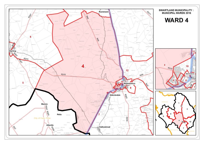
Abbotsdale 69.6% 28.8% 0.4% 0.2% 0.0% 0.0% 1.0%4 WARD DETAIL 4.1 WARD 4 (Chatsworth, Riverlands, Mount Royal (Malmesbury), Ruststasie and rural areas) (a) WARD 4 DESCRIPTION: Mount Royal golf estate (Malmesbury), Riverlands, Chatsworth, as well as the rural areas north-west, west and southern-west of Malmesbury.
(b)   WARD 4 COMMITTEE INFORMATION
WARD COUNCILOR: Basil Stanley

MEMBERS OF THE WARD COMMITTEE

Sector                   Member             Address              Town          Preferred Tel No       Email
Sosiale / Maatskaplike   Kariema Bruiners   Hutchinsonlaan 268   Chatsworth    (+27) 076 148 8822
Ontwikkeling
Jeugontwikkeling /       Hendrik Rezant     Milnerstraat 497     Chatsworth    (+27) 072 231 1892
Opvoeding
Munisipale               Johannes Cupido    Eerstelaan 885       Chatsworth    (+27) 071 975 8792
dienslewering /
infrastruktuur
Ekonomiese               Jacobus Martin     1760 York Street     Chatsworth    (+27) 072 052 2274
ontwikkeling             Coetzee
/Werkskepping
Sport / Ontspanning      Richard Jooste     881 Malmesbury Street Chatsworth   (+27) 072 882 5809     rjooste07@gmail.com
Kultuur / Toerisme /     Andrew Solomons    Posbus 39            Riverlands    (+27) 074 629 6797     vincorprojects@gmail.com
Omgewing                                    6 Arend Street
Landbou- en landelike John Farao            Posbus 40            Riverlands    (+27) 083 947 3041     jfarao@sahra.org.za
ontwikkeling (landelike                     45 Riverlands
dienslewering)
Gesondheid / Welsyn      Mary Strauss       Chamberlainstraat    Chatsworth    (27) 078 744 9159
                                            776
Landbou- en landelike Julian Susan Maans Queenstraat 521         Chatsworth    (+27) 063 825 7475     maansjulian@gmail.com
ontwikkeling (landelike
dienslewering)
Gemeenskapsveiligheid Frederick Mitchell    5de Laan 377         Chatsworth    (+27) 022 - 481 3830
(c) WARD 4 STATISTICS
The statistics mentioned below is a holistic picture of ward 4.
Population per group
Ward 4
Population Group
Number %
Black African 1 796 20.8%
Coloured 5 663 65.6%
Indian or Asian 89 1.0%
White 1 020 11.8%
Other 64 0.8%
TOTAL PER WARD 8 632 100.0%
Age distribution per category
Ward 0-9 years 10 – 19 years 20-29 years 30-39 years 40-41 years 50-59 years 60-69 years 70-79 years 80+ years
Ward 4 1 478 1 460 1 669 1 211 1 329 813 413 217 43
Average household size
Ward Number of households Average household size
Ward 4 2 134 4.0
Dwelling types
Ward House or Traditional Flat or Cluster Town- Semi- House/ Informal Informal Room/ flat Caravan/ Other
brick/ dwelling/ apart- house in house detached flat/ room dwelling dwelling let on a tent
concrete hut/ ment in a complex (semi- house in (shack in (shack not property
block structure block of detached backyard back- in or larger
structure made of flats house in a yard) backyard; dwelling/
on a traditional complex) e.g. in an servants
separate materials informal/ quarters/
stand or squatter granny flat
yard or on settlement
a farm or on a
farm)
Ward 4 1 618 8 11 1 5 202 10 30 140 15 4 90Official employment status
Ward Employed Unemployed Discouraged work- Other not Age less than 15 N/A
seeker economically years
active
Ward 4 3 151 418 156 2 332 0 2 574
Monthly income per household
Ward No Income R1 – 12 800 R12 800 – R25 600 R25 601 – R51 201 – R102 401 – R204 801+
R51 200 R102 400 R204 800
Ward 4 2 489 3 899 159 53 24 4 1
Households’ source of energy for lighting
Ward Electricity Gas Paraffin Candles (not Solar None Unspecified
a valid
option)
Ward 4 95.0% 0.1% 0.2% 4.2% 0.3% 0.2% 0.0%
Households’ source of refuse disposal
Ward Removed by local Removed by local Communal refuse Own refuse dump No rubbish disposal Other
authority/private authority/private dump
company at least company less often
once a week
Ward 4 34.0% 2.9% 10.5% 46.2% 4.7% 1.9%
Households’ source of water (Tap information)
Ward Piped (tap) Piped (tap) Piped (tap) Piped (tap) Piped (tap) Piped (tap) No access to
water inside water inside water on water on water on water on piped (tap)
dwelling yard community community community community water
stand : distance stand : between stand : between stand : distance
< 200m from 200m & 500m 500m & 1000m >1000m from
dwelling from dwelling from dwelling dwelling
Ward 4 74.1% 17.8% 6.3% 0.5% 0.3% 0.0% 1.0%(d) WARD 4 PRIORITY NEEDS
Most important needs prioritized per strategic goal
The following priorities were obtained from workshops held in the respective wards from the 22nd of February to the 01st of March 2018. Individuals
attending the workshops were given the opportunity to identify the most important priorities.
Ward 1 Priority needs (municipal mandates) 2018 Capex/ Budget Additional
Strategy
Rank Priority Description Opex 2018/19 2019/20 2020/21 2021/22 2022/23 comments
SG 4 - 1 Upgrading of The clinic is too small
INSTITUTIONS: the clinic Shortage of staff is a
Caring, problem
competent and Operational issues are
responsive problematic and the
institutions, doctor only comes from
organisations 13h00 or later.
and businesses
SG 4 - 2 Upgrading of Upgrade the primary
INSTITUTIONS: school in school in Chatsworth
Caring, Chatsworth
competent and
responsive
institutions,
organisations
and businesses
SG 3 - 3 Low cost Riverlands needs low cost
ENVIRONMENT: housing housing
Quality and An information session
sustainable must be held with the
living community to assist them
environment on how to register on the
database and how do a
person qualify.
SG 2 - 4 Promote and Assist with training facilities
ECONOMY: support (container)
Inclusive economic Computer training
economic opportunities provided by an
growth accredited facilitator
Assist with entrepreneurs
Infrastructure for
entrepreneurs / informal
tradersWard 1 Priority needs (municipal mandates) 2018 Capex/ Budget Additional
Strategy
Rank Priority Description Opex 2018/19 2019/20 2020/21 2021/22 2022/23 comments
Space for emerging
farmers to sell their
products on Saturdays.
SG 4 - 5 Satellite police Assist with a satellite police
INSTITUTIONS: station station
Caring,
competent and
responsive
institutions,
organisations
and businesses
SG 5 - SERVICES: 6 Sport and Assist with a multi-purpose
Sufficient, recreation centre where in and
affordable and facilities outdoor sports can take
well-run services place.
Temporary upgrading of
existing sport field in
Riverlands
Construction of a soccer
field in Riverlands with
associated facilities
SG 4 - 7 Library Provide a new library for
INSTITUTIONS: Riverlands
Caring, Enlarge the capacity of
competent and Chatsworth’s library
responsive
institutions,
organisations
and businesses
SG 5 - SERVICES: 8 Upgrading of Upgrade the roads in
Sufficient, roads Riverlands and
affordable and Chatsworth with hard
well-run services surface
SG 5 - SERVICES: 9 Tar of roads Tar the main road in
Sufficient, Chatsworth
affordable and
well-run services
SG 1 - PEOPLE: 10 More youth A facility where youthWard 1 Priority needs (municipal mandates) 2018 Capex/ Budget Additional
Strategy
Rank Priority Description Opex 2018/19 2019/20 2020/21 2021/22 2022/23 comments
Improved development programmes can be
quality of life for programmes offered
citizens Involve the community to
be part of the youth
programmes that are
offered
WARD 4 - OTHER NEEDS IDENTIFIED
Other needs of Ward 4 - 2018
Strategy Need Description
SG 1 - PEOPLE: Improved quality of life for Substance abuse support Assist with substance abuse in the area
citizens Facilities to prevent abuse
SG 2 - ECONOMY: Inclusive economic Development of a petro port Assist with a petro port because the nearest petrol station is in
growth Malmesbury or Atlantis
SG 5 - SERVICES: Sufficient, affordable More lighting Provide lighting on the sports field in third avenue
and well-run services
SG 3 - ENVIRONMENT: Quality and Upgrade parks Replace steel equipment because it gets very hot in the
sustainable living environment summer
Assist with more parks in Chatsworth
Plant more trees
SG 3 - ENVIRONMENT: Quality and Open spaces must be cleaned Clean all the municipal owned open spaces
sustainable living environment
SG 3 - ENVIRONMENT: Quality and Removal of stray animals Need an animal pound that’s not far from the communities
sustainable living environment Identify alternative space where animals can be kept
Awareness campaigns of the rights of animal owners
SG 5 - SERVICES: Sufficient, affordable Refuse removal There’s a problem with the new service provider. The vehicle is
and well-run services not suitable for the removal of refuse and some of the houses'
refuse are not removed.
Skips must be removed.
Rubbish bins to be provided.
SG 5 - SERVICES: Sufficient, affordable Cleaning of storm water systems Clean all the storm water systems in Riverlands
and well-run services Not enough drainage and tarred roads are being damaged
The drain opposite the clinic has completely collapsed4.2 WARD 7 (Abbotsdale, Kalbaskraal and rural areas) (a) WARD 7 DESCRIPTION: Kalbaskraal, Abbotsdale as well as the rural area south and south-east of Malmesbury.
(b)     WARD 7 COMMITTEE INFORMATION
WARD COUNCILOR: Valerie McQuire

MEMBERS OF THE WARD COMMITTEE

Sector                      Member                 Address                 Town          Preferred Tel No     Email
Gemeenskapsveiligheid Roger C Levendall            Langstraat 505          Abbotsdale    (+27) 084 210 4834
Jeugontwikkeling /          Christiaan Lewis       Thembelillestraat 604   Kalbaskraal   (+27) 063 895 4299
Opvoeding
                            Paulina                Kloofstraat 70          Abbotsdale    (+27) 071 022 3328   paulinewhites24@gmail.com
                            Onverwacht
Ekonomiese                  Sophia Booysen         Kransvoëlstraat 304     Kalbaskraal   (+27) 078 277 1804
Ontwikkeling /
Werkskepping
Sosiale / Maatskaplike      Charmaine Stallard Spoorwegstraat 158          Abbotsdale    (+27) 084 670 1210   charmstallard@gmail.com
Ontwikkeling
Munisipale                  Elizabeth Daniëls      Rivierstraat 310        Kalbaskraal   (+27) 060 679 8640
dienslewering /
infrastruktuur
Sport / Ontspanning         Reginald Fry           Boltneystraat 1         Abbotsdale    (+27) 076 414 2971

(c)     WARD 7 STATISTICS
The statistics mentioned below is a holistic of ward 7.

Population per group

                                            Ward 7
Population Group
                                     Number                  %
Black African                              2 434       16.7%
Coloured                               10 640          73.0%
Indian or Asian                              34         0.2%
White                                      1 391        9.5%
Other                                        69         0.5%
TOTAL PER WARD                         14 568         100.0%
Age distribution per category
Ward 0-9 years 10 – 19 years 20-29 years 30-39 years 40-41 years 50-59 years 60-69 years 70-79 years 80+ years
Ward 7 2 521 2 329 2 826 2 485 2 282 1 153 638 251 83
Average household size
Ward Number of households Average household size
Ward 7 3 434 4.2
Dwelling types
Ward House or Traditional Flat or Cluster Town- Semi- House/ Informal Informal Room/ flat Caravan/ Other
brick/ dwelling/ apart- house in house detached flat/ room dwelling dwelling let on a tent
concrete hut/ ment in a complex (semi- house in (shack in (shack not property
block structure block of detached backyard back- in or larger
structure made of flats house in a yard) backyard; dwelling/
on a traditional complex) e.g. in an servants
separate materials informal/ quarters/
stand or squatter granny flat
yard or on settlement
a farm or on a
farm)
Ward 7 2 760 4 47 17 1 243 90 140 39 46 15 32
Official employment status
Ward Employed Unemployed Discouraged work- Other not Age less than 15 N/A
seeker economically years
active
Ward 7 5 385 735 134 4 078 0 4 235
Monthly income per household
Ward No Income R1 – 12 800 R12 800 – R25 600 R25 601 – R51 201 – R102 401 – R204 801+
R51 200 R102 400 R204 800
Ward 7 4 832 6 685 321 78 16 9 1Households’ source of energy for lighting
Ward Electricity Gas Paraffin Candles (not Solar None Unspecified
a valid
option)
Ward 7 96.8% 0.2% 0.0% 2.5% 0.2% 0.2% 0.0%
Households’ source of refuse disposal
Ward Removed by local Removed by local Communal refuse Own refuse dump No rubbish disposal Other
authority/private authority/private dump
company at least company less often
once a week
Ward 7 63.9% 2.8% 6.0% 22.7% 1.6% 2.9%
Households’ source of water (Tap information)
Ward Piped (tap) Piped (tap) Piped (tap) Piped (tap) Piped (tap) Piped (tap) No access to
water inside water inside water on water on water on water on piped (tap)
dwelling yard community community community community water
stand : distance stand : between stand : between stand : distance
< 200m from 200m & 500m 500m & 1000m >1000m from
dwelling from dwelling from dwelling dwelling
Ward 7 67.8% 26.8% 3.0% 0.7% 0.2% 0.0% 1.4%(d) WARD 7 PRIORITY NEEDS
Most important needs prioritized per strategic goal
The following priorities were obtained from workshops held in the respective wards from the 22nd of February to the 01st of March 2018. Individuals
attending the workshops were given the opportunity to identify the most important priorities.
Ward 1 Priority needs (municipal mandates) 2018 Capex/ Budget Additional
Strategy
Rank Priority Description Opex 2018/19 2019/20 2020/21 2021/22 2022/23 comments
SG 3 - 1 Housing Provide houses in
ENVIRONMENT: Kalbaskraal and
Quality and Abbotsdale
sustainable
living
environment
SG 4 - 2 Library Need a library in
INSTITUTIONS: Kalbaskraal (children must
Caring, take busses to Abbotsdale
competent and and then it's not open
responsive when they arrive there or
institutions, it closes early)
organisations
and businesses
SG 5 - SERVICES: 3 Soccer field Assist with a soccer field in
Sufficient, Abbotsdale and
affordable and Kalbaskraal
well-run services
SG 4 - 4 Larger primary Assist with an extension of
INSTITUTIONS: school in the primary school
Caring, Abbotsdale
competent and
responsive
institutions,
organisations
and businesses
SG 5 - SERVICES: 5 Tar roads Kalbaskraal: Frahms
Sufficient, Avenue, Eikehout Avenue
affordable and Abbotsdale: Spoorweg
well-run services Street
SG 1 - PEOPLE: 6 Recreational Facilities for the youth
Improved facilities such an internet caféWard 1 Priority needs (municipal mandates) 2018 Capex/ Budget Additional
Strategy
Rank Priority Description Opex 2018/19 2019/20 2020/21 2021/22 2022/23 comments
quality of life for Braai facility
citizens
SG 1 - PEOPLE: 7 New Provide a new
Improved multipurpose multipurpose centre for
quality of life for centre in Kalbaskraal
citizens Kalbaskraal
SG 1 - PEOPLE: 8 Better law Law enforcement must be
Improved enforcement more visible in the
quality of life for services residential area
citizens (especially in Kalbaskraal
where school children
cross the roads in the
mornings and afternoons)
SG 2 - 9 Promote Support entrepreneurship
ECONOMY: economic Attract investment to build
Inclusive development a supermarket in
economic in both areas Abbotsdale
growth Assist with space for
informal trading
Assist with business training
Promote a business/
industrial hub
SG 5 - SERVICES: 10 Disable friendly Make sidewalks suitable
Sufficient, building and for disabled people
affordable and Infrastructure Ensure that all municipal
well-run services buildings and ablution
facilities are disabled
friendly
WARD 7 - OTHER NEEDS IDENTIFIED
Other needs of Ward 7 - 2018
Strategy Need Description
SG 2 - ECONOMY: Inclusive economic Assist with job creation through other Ensure development and construction companies must use
growth programmes and companies local labour
Cleaning of streets through the CWP
SG 5 - SERVICES: Sufficient, affordable More lighting Kalbaskraal: Assist with lighting at the northern side of the
and well-run services Saldanha railway, at the eastern side (to the Cape’s) of the
railway and at the western side of the freeway from the N7 upOther needs of Ward 7 - 2018
Strategy Need Description
to the main road of Kalbaskraal.
Abbotsdale: From the bridge up to Darling road.
SG 1 - PEOPLE: Improved quality of life for Upgrading of playparks Upgrade of equipment
citizens Provide more sand at the parks
SG 5 - SERVICES: Sufficient, affordable Speedbumps in residential area Abbotsdale - Lang Street, Jacaranda Street
and well-run services
SG 4 - INSTITUTIONS: Caring, competent Upgrading of clinic in Kalbaskraal Assist with a shed at the clinic in Kalbaskraal
and responsive institutions, organisations
and businesses
SG 4 - INSTITUTIONS: Caring, competent New clinic in Abbotsdale Build a new clinic in Abbotsdale
and responsive institutions, organisations
and businesses
SG 1 - PEOPLE: Improved quality of life for More ward meetings Ensure more ward meetings
citizens4. MUNICIPAL BUDGET 2018/2019
Capital budget applicable to wards 4 and 7:
Budget
Project Ref Project Description
2018/2019 2019/2020 2020/2021 2021/2022 2022/2023
WARD 4
17-0016 Roads: Upgrading and Diversion: Kalbaskraal Riverlands Pipeline 2 664 000
(N7 construction works)
17-0074 Upgrading of Sports Grounds: Chatsworth 2 349 895
WARD 7
14-0024 Community Development: Multi-Purpose: Kalbaskraal 7 000 000
18-0019 Housing Abbotsdale Social Economic Facility Project 1 500 000
17-0016 Roads: Upgrading and Diversion: Kalbaskraal Riverlands Pipeline 2 664 000
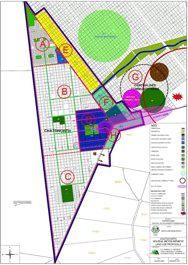
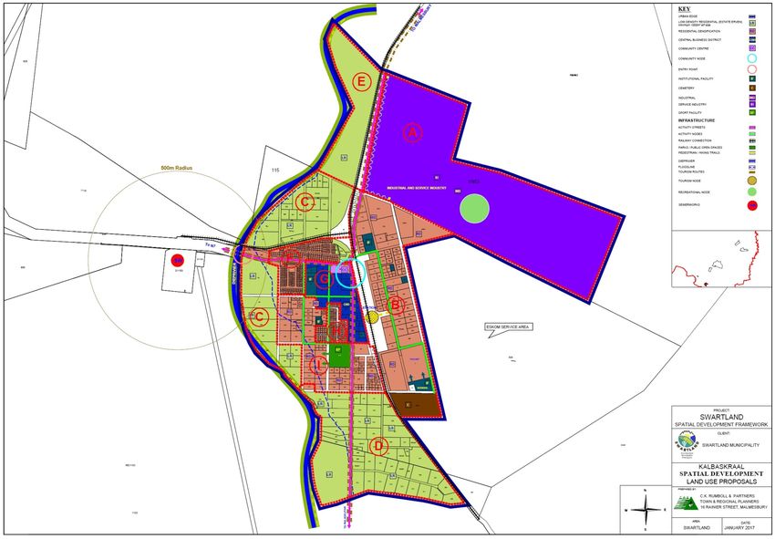
(N7 construction works)ANNEXURE1: SPATIAL DEVELOPMENT FRAMEWORK PROPOSALS The Swartland Spatial Development Framework (SDF) is a document that sets out the necessary policy guidelines to guide spatial development in the municipal area in a desirable and sustainable manner. The future growth, development and land use planning in the municipal area must be based on the vision and principles that was agreed upon to address spatial challenges/problems and to ensure the creation and support of integrated, sustainable and liveable environments through the creation and support of socio economic opportunities.
RIVERLANDS
LOCAL SPATIAL DEVELOPMENT PROPOSALS
RIVERLANDS:
Rural Settlement: Improve the mobility of local communities to allow better access to economic opportunities.
Themes(T) and Proposals Actions
Strategies(S)
Connectivity
Roads:
T1 S5 Maintain and support the upgrade of the local movement network Municipality to take pro-active role in liaising with Provincial and
including Riverlands Avenue as main activity route and route National roads departments to have insight in the upgrading or
through town to the Riverlands Reserve. surrounding road networks including Riverlands Avenue that runs
through Riverlands and provide access to the town off the N7,
and the N7 as main route.
Activity Streets (Spatial Integration):
T1 S5 Support the development of mixed uses along the activity corridor Upgrading and beautification of Riverlands Avenue as the main
T5 S12 along Riverlands Avenue and along identified internal activity activity corridor in Riverlands. Utilise the entry points to town as
streets as identified on movement network plan to support social focal points and use tree planting, street furniture and pedestrian
and economic integration. walkways to increase visual quality of the town.
Beautification of main activity corridor and entry to Riverlands. Support the development of a taxi rank/bus stop in front of school
Introduce elements on road to reduce speed of passing vehicles to site to increase mobility of local community and provide them
increase safety along this route. Use of raised pedestrian crossings access to economic opportunities in surrounding area.
and raised area around an intersection to ensure people reduce
speed.
Concentrate and support development of higher order uses along
identified activity streets to support integration and spatial justice.
Increase individual mobility of residents with provision of adequate
public transport facilities.
Consider Railway transport as possible alternative public transport
system for the people of the Greater Chatsworth area.
Pedestrian and Bicycle routes:
T1 S1 Improve mobility in town with the provision of accessible and safe Development of a safe and functional pedestrian walkway in
T1 S5 pedestrian walkways (surfaced with shaded areas and provide town as well as between Riverlands and Chatsworth to allow for
T5 S12 adequate lighting) and cycle paths. spatial integration.
Improve accessibility of sidewalks, road crossings and pedestrian
walkways for disabled people in accordance with national
standards.Themes(T) and Proposals Actions
Strategies(S)
Public Areas
Public Nodes
T5 S12 Spatial Integration Development of land between Riverlands and Chatsworth, known
T6 S14 Support the spatial integration between Riverlands and Chatsworth as Michiel Heyns Kraal, by Department of Human Settlements as
with the building of a multipurpose community centre and other owner. Land earmarked for urban expansion on the Chatsworth
supporting social/sport infrastructure in a central area between the side, development of an integrated community node on the
two towns. southern portion between Riverlands and Chatsworth, the
Potential for the development of the area between Riverlands and formalisation of existing small farmers and the extension of an
Chatsworth for the settlement of small farmers and as an ecological ecological corridor.
corridor. Formalising the settlement of small farmers in surrounding area to
Support the development of mixed uses along the activity corridor. the north and east of town in area known as Vetkoekheuwel.
Support more intensive agricultural use as well as smaller agricultural Support the development of a multipurpose community centre
units in surrounding rural areas around Riverlands and Chatsworth, along the link road between Riverlands and Chatsworth to serve
including Groenrivier Smallholdings and Tierfontein to allow for the Greater Chatsworth area.
increased production, better utilisation of land, allow more people
access to agriculture land with lower land tax.
T1 S5 Development of a centralised sport fields to serve as an active Development of area around retention pond as possible
T5 S12 public node in Riverlands, functional open space area.
T6 S14 Create an active and functional open space network. Secure the area and provide play park facilities.
Utilise part of Taxi rank/bus stop in front of school as market place Provide Public Park along tributary of Swart River.
with beatification of the area.
Community Facilities
T5 S12 Provide supportive and shared community facilities in a central Development of new school site by the Department of Education.
T6 S14 location between Riverlands and Chatsworth. Formalise the area around the retention pond in Pelican Street as
Formalise existing open space area as functional spaces. local picnic area – secure the dam.
Continue with development of the expansion of the cemetery as Formalise the area along the tributary. To the west of the school,
identified on northern boundary. with landscaping and hiking routes.
Support the provision of adequate: Identification of area for Multi-functional facility.
o Primary health facilities; Expansion of cemetery on northern boundary.
o Education facilities with focus on crèches and secondary Development of larger integrated sport facility as part of the
facilities – new school site. multipurpose community facility in central position between the
Support the provision of community orientated services (crèches) in towns.
the residential areas.
Upgrading of existing sport facilities east of school.
Development of a larger sport node that will serve Greater
Chatsworth area.Themes(T) and Proposals Actions
Strategies(S)
Natural Conservation areas, Open Space Networks and Corridors and Rivers
T3 S8 Identify conservation areas in and around Riverlands. Provide formal status to natural conservation areas and enter into
T3 S9 Support the more effective use of natural/open space areas in and a stewardship programme with Cape Nature to ensure effective
T6 S15 around urban areas for recreation purposes for the communities management of these areas.
T1 S2 with development of hiking trails, mountain bike trails and Support the development of a conservation corridor between
alternative uses for events facilities and venues. Riverlands Nature Reserve and Pella Nature Reserve to the north
Provide a corridor between Riverlands and Pella Nature Reserve to of Riverlands.
the north of the town that include a part of the farm Michiel Heyns Development of effective management plans for conservation
Kraal. areas.
T5 S12 Support the development of an open space network in Riverlands. Development of and functional open space networks with
More effective use of open space networks by providing formal provision of walking trails, landscaping and recreational facilities
walking trails and recreational facilities within these areas. (play parks, picnic areas, outdoor gym equipment).
T4 S8 Support interactive development along open spaces where Developments next to open space areas to interact with these
developments face the open space networks. features.
Heritage features
T4 S10 Support effective control of the demolition and extension of
heritage buildings.
Tourism
T1 S4 Riverlands location along the access route to the Riverlands Reserve Focus tourism development on the natural environment, nature
provides the town and surrounds with limited tourism potential. reserves in the area and wild flowers.
Support the cultivation and harvesting of wild flowers in the area.
Market the area during spring as a hotspot to view wild flowers.
Support Agri Tourism in surrounding area.
Private Areas
Residential
T5 S12 Allow farm workers to be included in waiting list to be included as All future subsidised housing demands in the Greater Chatsworth
T5 S13 beneficiaries for housing projects. area to be addressed in Malmesbury.
Keep waiting list up to date.
Formalise the rural settlement area Vetkoekheuwel, outside of
Riverlands along the Swart River, with a formal layout,
formalisation of ownership, installation of services and provision of
formal access road to the area to allow security of tenure and
better management of the area.
T5 S13 Spatially allow for adequate areas for provision of different Utilise of developable vacant areas as identified in Vacant land
T5 S11 residential types. Audit for future development and infill development.
T5 S12 New residential developments to be sustainable and integrated to Support renewal with higher density residential uses in and around
allow for different housing options and the effective utilisation of the CBD and along activity streets.
services. Support subdivision of single residential erven with minimum size of
Small area for residential expansion on the northern periphery of 500m² allowed for in Riverlands.Themes(T) and Proposals Actions
Strategies(S)
town and directly east at the entry to town. Finalise the municipal GAP development in the northern part of
Riverlands with the creation of 14 erven to be sold.
T5 S11 Develop areas in accordance with availability and capacity of Plan for expansion of bulk infrastructure to support future limited
infrastructure and services. residential growth.
Residential growth to focus on private developments and Gap
opportunities.
T5 S12 Support the densification in Riverlands through: Allow for minimum subdivision size of single residential erven of
o Subdivision; 500m².
o Infill development; Investigate the provision of GAP housing in Riverlands.
o Renewal and restructuring.
Densification in accordance with zone proposals.
Future subdivision and renewal need to be done in the context of
surrounding densities and character of existing built up areas.
Neutral Areas
Commercial
T1 S1 Support the existing CBD along Riverlands Avenue. Formalise the existing commercial area on the south eastern
Support the development of house shops/home occupation in periphery of the town and create opportunities for housing and
residential areas to support economic growth and diversification. service industries around this node.
T5S12 Create more affordable commercial properties and create more Support integrated development and mixed uses in
integrated commercial areas in previously disadvantaged neighbourhoods.
neighbourhoods to allow more people access to these
opportunities.
Industrial
T1 S1 Support the development of limited opportunities for service Provide the opportunities for limited service related industries on
T1 S2 industries in identified areas. the southern periphery of town along both sides of the activity
corridor.
T5 S11 Ensure adequate capacity of bulk infrastructure to support industrial Identify areas for future expansion of bulk infrastructure.
expansion.
Bulk Infrastructure and Services
T5 S11 Allow adequate area for provision of bulk infrastructure that include Ensure bulk infrastructure planning is in line with SDF growth
T3 S8 reservoirs, overhead power lines, future roads and water pipeline. proposals.
T4 S8 The combined Waste Water Treatment Works to serve the towns Identify the areas earmarked for expansion of bulk infrastructure.
within the Greater Chatsworth area. Ensure that the locality of these infrastructure features is in line with
SDF proposals and does not impact on the landscape qualities in
the Swartland.
Support the upgrading of the Waste Water Treatment Plant.
T3 S7 Support the sustainable use natural resources through alternative Support effective use of natural resources i.e. alternative energy,
T6 S15 methods – i.e. harvesting of rainwater in tanks on residential erven, water wise developments.Themes(T) and Proposals Actions
Strategies(S)
use of alternative energy sources.CHATSWORTH
LOCAL SPATIAL DEVELOPMENT PROPOSALS
Chatsworth:
Rural Settlement: Improve the mobility of local communities to allow better access to economic opportunities.
Themes(T) and Proposals Actions
Strategies(S)
Connectivity
Roads:
T1 S5 Maintain and support the upgrade of the local movement network Municipality to take pro-active role in liaising with Provincial and
including Randor Street as a local activity corridor, that also form National roads departments to have insight in the upgrading or
part of the bus route through Chatsworth. surrounding road networks.
Beautification of Randor Street as the main entry to Chatsworth as
well as other activity streets in the CBD.
Activity Streets (Spatial Integration):
T1 S5 Support the development of mixed uses along the activity corridor Upgrading and beautification of Randor Avenue, as the main
T5 S12 along the entry road to Chatsworth. activity corridor in Chatsworth, as well as the connection route
Mixed use development (higher density residential and commercial) between Riverlands and Chatsworth. Utilise the entry points to
along Randor Street as activity axis and along identified internal town as focal points and use tree planning, street furniture and
activity streets as identified on movement network plan to support pedestrian walkways to increase visual quality of the town.
social and economic integration. Support the development of a taxi rank/bus stop next to CBD to
Beautification of main activity corridor and entry to Chatsworth. increase mobility of local community and provide them access to
Introduce elements on road to reduce speed of passing vehicles to economic opportunities in surrounding area.
increase safety along this route. Use of raised pedestrian crossings Expand bus route to northern part of town where the newly
and raised area around an intersection to ensure people reduce developed housing project is located.
speed.
Concentrate and support development of higher order uses along
identified activity streets to support integration and spatial justice.
Increase individual mobility of residents with provision of adequate
public transport facilities.
Consider Railway transport as possible alternative public transport
system for the people of the Greater Chatsworth area.
Pedestrian and Bicycle routes:
T1 S1 Improve mobility in town with the provision of accessible and safe Development of a safe and functional pedestrian walkway in
T1 S5 pedestrian walkways (surfaced with shaded areas and provide town as well as between Riverlands and Chatsworth to allow for
T5 S12 adequate lighting) and cycle paths. spatial integration.
Public Areas
Public Nodes
T5 S12 Spatial Integration Development of land between Riverlands and Chatsworth, knownThemes(T) and Proposals Actions
Strategies(S)
T6 S14 Support the spatial integration between Riverlands and Chatsworth as Michiel Heyns Kraal, by Department of Human Settlements as
with the building of a multipurpose community centre and other owner. Land earmarked for urban expansion on the Chatsworth
supporting social/sport infrastructure in a central area between the side, development of an integrated community node on the
two towns. southern portion between Riverlands and Chatsworth, the
Potential for the development of the area between Riverlands and formalisation of existing small farmers and the extension of an
Chatsworth for the settlement of small farmers and extension of an ecological corridor.
ecological corridor. Formalising the settlement of small farmers in surrounding area to
Support the development of mixed uses along the activity corridor. the west of town
Support more intensive agricultural use as well as smaller agricultural Support the development of a multipurpose community centre
units in surrounding rural areas around Riverlands and Chatsworth, along the link road between Riverlands and Chatsworth to serve
including Groenrivier Smallholdings and Tierfontein to allow for the Greater Chatsworth area.
increased production, better utilisation of land, allow more people
access to agriculture land with lower land tax.
T1 S5 Development of a centralised community node to the north of the Upgrading of the public node in the CBD to be uses as a market
T5 S12 link road between Chatsworth and Riverlands, by providing sport, place.
T6 S14 Thusong and other relevant community services in the areas. Support the development of an integrated community service
Create an active and functional open space network. node in a central location between Chatsworth and Riverlands.
Utilise part of Taxi rank/bus stop in the northern part of town close to
new housing project.
Community Facilities
T5 S12 Provide supportive and shared community facilities in a central Development of new school site by the Department of Education.
T6 S14 location between Riverlands and Chatsworth. Formalise the public area in CBD as local market square that can
Formalise existing open space area as functional spaces. be used for formal trading, combine with bus and taxi stop.
Continue with development of the expansion of the cemetery as Formalise the open space system.
identified on eastern boundary. Development of larger integrated sport facility as part of the
Support the provision of adequate: multipurpose community facility in central position between the
o Primary health facilities; towns.
o Education facilities with focus on crèches and secondary Consider the creation of a new cemetery in the central node
facilities – new school site. between Riverlands and Chatsworth to serve Greater Chatsworth
Support the provision of community orientated services (crèches) in community.
the residential areas.
Development of a larger sport node that will serve Greater
Chatsworth area.
Building of a wall between the Christian and Moslem part of
cemetery.
Natural Conservation areas, Open Space Networks and Corridors and Rivers
T3 S8 Identify conservation areas in and around Chatsworth. Provide formal status to natural conservation areas and enter into
T3 S9 Support the more effective use of natural/open space areas in and a stewardship programme with Cape Nature to ensure effective
T6 S15 around urban areas for recreation purposes for the communities management of these areas.Themes(T) and Proposals Actions
Strategies(S)
T1 S2 with development of hiking trails, mountain bike trails and Support the development of a conservation corridor between
alternative uses for events facilities and venues. Riverlands Nature Reserve and Pella Nature Reserve to in the
Provide a corridor between Riverlands and Pella Nature Reserve to northern section of Michiel Heyns Kraal.
the north of the town that include a part of the farm Michiel Heyns Development of effective management plans for conservation
Kraal. areas.
T5 S12 Support the development of an open space network in Chatsworth. Development of and functional open space networks with
More effective use of open space networks by providing formal provision of walking trails, landscaping and recreational facilities
walking trails and recreational facilities within these areas. (play parks, picnic areas, outdoor gym equipment).
T4 S8 Support interactive development along open spaces where Developments next to open space areas to interact with these
developments face the open space networks. features.
Heritage features
T4 S10 Support effective control of the demolition and extension of
heritage buildings.
Tourism
T1 S4 Support the cultivation and harvesting of wild flowers in the area. Focus tourism development on the natural environment, nature
Market the area during spring as a hotspot to view wild flowers. reserves in the area and wild flowers.
Support Agri Tourism in surrounding area.
Private Areas
Residential
T5 S12 Allow farm workers to be included in waiting list to be included as Finalise the proposed housing project to address backlogs from
T5 S13 beneficiaries for housing projects. the past along the north eastern periphery of the town, in area
identified for urban expansion. Formalisation of the small farmers
in the area between Chatsworth and Riverlands. Projects to be
developed by the Department of Human Settlements.
All future subsidised housing demands in the Greater Chatsworth
area to be addressed in Malmesbury.
Keep waiting list up to date.
T5 S13 Spatially allow for adequate areas for provision of different Utilise of developable vacant areas as identified in Vacant land
T5 S11 residential types. Audit for future development and infill development.
T5 S12 New residential developments to be sustainable and integrated to Support renewal with higher density residential uses in and around
allow for different housing options and the effective utilisation of the CBD and along activity streets.
services. Support subdivision of single residential erven with minimum size of
Urban expansion along the Eastern periphery of town. Land owned 400m² allowed for in Chatsworth.
by Department of Human Settlements with small subsidised project
planned within this area.
T5 S11 Develop areas in accordance with availability and capacity of Plan for expansion of bulk infrastructure to support future limited
infrastructure and services. residential growth.
Residential growth to focus on private developments and GapThemes(T) and Proposals Actions
Strategies(S)
opportunities.
T5 S12 Support the densification in Chatsworth through: Allow for minimum subdivision size of single residential erven of
o Subdivision; 400m².
o Infill development; Investigate the provision of GAP housing in Riverlands.
o Renewal and restructuring.
Densification in accordance with zone proposals.
Future subdivision and renewal need to be done in the context of
surrounding densities and character of existing built up areas.
Neutral Areas
Commercial
T1 S1 Support the existing CBD at the entry to Chatsworth as well as a Support the development of the business nodes and allow for
secondary node in the northern part of town. mixed uses along activity corridors and activity streets.
Support the development of an activity corridor along the entry Support development of an activity corridor at the entry to town.
road to Chatsworth and an activity node at the entry point to allow
for various mixed uses including commercial and service industries
to stimulate the local economy.
Support the development of house shops/home occupation in
residential areas to support economic growth and diversification.
T5S12 Create more affordable commercial properties and create more Support integrated development and mixed uses in
integrated commercial areas in previously disadvantaged neighbourhoods.
neighbourhoods to allow more people access to these
opportunities.
Industrial
T1 S1 Support service and light industrial related development in Zone F Provide the opportunities for limited service and light industries on
T1 S2 and along the activity corridor at the entry to town in Zone H to the along the activity corridor.
allow for more economic opportunities.
T5 S11 Ensure adequate capacity of bulk infrastructure to support industrial Identify areas for future expansion of bulk infrastructure.
expansion.
Bulk Infrastructure and Services
T5 S11 Allow adequate area for provision of bulk infrastructure that include Ensure bulk infrastructure planning is in line with SDF growth
T3 S8 reservoirs, overhead power lines, future roads and water pipeline. proposals.
T4 S8 The combined Waste Water Treatment Works to serve the towns Identify the areas earmarked for expansion of bulk infrastructure.
within the Greater Chatsworth area. Ensure that the locality of these infrastructure features is in line with
SDF proposals and does not impact on the landscape qualities in
the Swartland.
Support the upgrading of the Waste Water Treatment Plant.
T3 S7 Support the sustainable use natural resources through alternative Support effective use of natural resources i.e. alternative energy,
T6 S15 methods – i.e. harvesting of rainwater in tanks on residential erven, water wise developments.You can also read