JULY 26 2018 - City of Victoria
←
→
Page content transcription
If your browser does not render page correctly, please read the page content below
JULY 26 2018
Publishing Information

Title:                    Zoning Bylaw 2018

Prepared By:              City of Victoria
                          Sustainable Planning and Community Development Department

Status:                   Adopted July 26, 2018

Contact Details:          City of Victoria
                          Sustainable Planning and Community Development Department
                          1 Centennial Square
                          Victoria, BC V8W 1P6
                          E: planning@victoria.ca
                          W: victoria.ca

This consolidation is a copy of a bylaw consolidated under the authority of section 139 of the Community Charter.
(Consolidated on March 18, 2019 up to Bylaw No. 19-029)
This bylaw is printed under and by authority of the Corporate Administrator of the Corporation of the City of Victoria.
Zoning Bylaw 2018 – Summary of Amendments
Date Bylaw Number Description
January 17, 2019 18-115 1400 Quadra Street rezone from the CBD-1 and
MRD-1 zones to the CBD-2 zone
March 18, 2019 19-029 Add administrative definition for Residential Rental
Tenure
October 1, 2020 20-075 Add administrative definition for Energized
Electric Vehicle Outlet and Electric Vehicle Energy
Management System and establish electric vehicle
charging design standards
January 14, 2021 20-117 901 Gordon Street rezone from OTD-1 zone to
OTD-1 - Site Specific zone
January 14, 2021 20-125 1150 Douglas Street rezone from OTD-1 zone to
OTD-1 - Site Specific zoneBYLAW NO. 18-072
ZONING BYLAW 2018
A BYLAW OF THE CITY OF VICTORIA
The purpose of this bylaw is to divide the City into zones and to regulate and control the use of land and buildings
within those zones.
Table of Contents
Part 1 - Administration
1.1 Interpretation 1
Part 2 - Definitions
2.1 Administrative Definitions 5
2.2 Use Definitions 12
Part 3 - Use of Land, Buildings and Structures
3.1 General Regulations 15
Part 4 - Zones
4.1 Central Business District – 1 Zone (CBD-1) 17
4.2 Central Business District – 2 Zone (CBD-2) 25
4.3 Mixed Use Residential District – 1 Zone (MRD-1) 40
4.4 Old Town District -1 Zone (OTD-1) 41
Part 5 - Requirements for Motor Vehicle and Bicycle Parking
5.1.1 Off-Street Parking Requirements 52
5.1.2 Vehicle Parking Appearance 54
5.1.3 Vehicle Parking Location and Dimensions 54
5.1.4 Bicycle Parking Specifications 56
5.1.5 Bicycle Parking Exemptions 58
Part 6 - Schedules
Schedule-A: CBD-2 Zone Height Areas Map 59
Schedule-B: Small Scale Commercial Urban Agriculture 60
Pursuant to its statutory powers, including sections 479, 482, and 525 of the Local Government Act, the Council of
the Corporation of the City of Victoria, in an open meeting assembled, enacts the following provisions:Part 1 - Administration
1.1 Interpretation
1. This bylaw may be cited as the “Zoning Bylaw 2018”
2. This bylaw applies to the area indicated with a dashed line in Map 1.
Map 1: Area subject to Zoning Bylaw 2018
3. The Zoning Regulation Bylaw No. 80-159 is inapplicable to the area indicated within the dashed
line in Map 1.
4. The area to which this bylaw applies is divided into the zones indicated on the Zoning Map, being
the zoning information layer in VicMap.
Page 1 of 62Part 1 - Administration
4.1 In all civil and criminal judicial proceedings a printout of the Zoning Map, purporting to
be certified as such, shall be prima facie evidence of the location of each zone and of
the lands included therein as at and since the date of the certificate, without proof of the
signature or approval of the Director.
4.2 Whenever any land is removed from one zone into another by a rezoning bylaw the
Director shall, forthwith after the adoption of the such bylaw, cause the Zoning Map to be
updated to reflect the changes.
5. The regulations, requirements and definitions in Parts 1 through 6 of this bylaw apply to land in
the area to which this bylaw applies in accordance with the zoning designations indicated on
the Zoning Map, and if Parts 3 through 6 specify regulations and requirements for a particular
location within a zone that is identified by civic address, legal description or both, then the specific
regulations and requirements take precedence over the general regulations and requirements for
the zone.
5.1 Without limiting the scope of section 5, where a property is specifically identified in
column A of the “Site Specific Regulations” table in the zone regulations applicable to that
property, the specific regulations and requirements set out in column B of that table apply,
subject to the conditions or requirements to provide amenities set out in column C, if any.
5.2 Where a property is divided into two or more development areas (DA) as shown in a plan
included in the applicable “Site Specific Regulations” table, section 5.1 applies to each
development area as if that development area was a separate property.
5.3 In the event of a conflict, the regulations or requirements applicable pursuant to section
5.1 apply despite any other provisions of this bylaw.
5.4 Where a property to which section 5.1 applies is subdivided, section 5.1 applies to all
properties that had formerly formed part of that property as if they were individually listed
in the table.
5.5 Where a property to which section 5.1 applies is consolidated or otherwise merged with
another property, section 5.1 applies only to that part of the new property to which section
5.1 applied before consolidation or merger.
5.6 Where a property is identified in this bylaw by reference to a civic address and a legal
description, the legal description shall be deemed to be the correct description in the
event of any conflict or inconsistency.
6. For certainty, if the Zoning Map indicates that a Lot lies within two or more zones, each portion
of the Lot may be used and built upon only in accordance with the regulations and requirements
applicable to that portion under Part 3 or 4.
7. Unless otherwise indicated on the Zoning Map:
7.1 Streets and lanes are deemed to have the same zoning designation as the abutting land,
and any zone boundary that coincides with a Street or lane is deemed to be located at
the centerline of the Street or lane;
7.2 Any zone boundary that coincides with a railway right of way is deemed to be located at
the centreline of the right of way;
7.3 The surface of all water is within the same zone as the nearest land to it within the City
boundaries unless zoned otherwise; and
Page 2 of 62Part 1 - Administration
7.4 Whenever any land, fronting on a Street, railway, or water, is removed from one zone
and placed into another that portion of the Street, railway, or water to which this section
applies shall also be so removed and rezoned.
8. For the purposes of this bylaw, an airspace parcel is deemed to be part of the same Lot as the
parcel at ground level.
9. In the event of any inconsistency between the text of this bylaw and an illustration or diagram that
relates to the text, the text takes precedence over the illustration or diagram.
10. No person shall use land or a Building or structure, or allow or permit another person to do so,
except in accordance with this bylaw.
11. No person shall place, erect, construct or alter a Building or structure, or allow or permit another
person to do so, except in accordance with this bylaw.
12. Not more than one Building other than an Accessory Building shall be erected or used on one
Lot, unless the regulations applicable in a particular zone expressly permit otherwise, and no
Building shall be erected partly on one Lot and partly on another.
13. No person shall use land or a Building or structure, or allow or permit another person to do so,
except in accordance with the requirements of this bylaw in respect of the provision of motor
vehicle and bicycle parking spaces, the provision of Loading Spaces and the provision of
screening or landscaping.
14. An officer or employee of the City appointed to administer this bylaw may enter on land including
any place that is occupied as a private dwelling, to inspect and determine whether the regulations
and requirements in this bylaw are being met, and in the case of a private dwelling may enter only
in accordance with s. 16(5) of the Community Charter.
15. A person who contravenes this bylaw is liable to a maximum fine of $10,000 and, in the case of a
continuing offence, each day on which the contravention continues constitutes a separate offence
that is subject to that maximum fine.
16. This bylaw may be enforced by means of a municipal ticket information, in which case the offence
descriptions and ticket fines set out in the Ticket Bylaw apply.
17. The figure indicated in a column of section 2, Part 4 of this bylaw adjacent to the heading
“Density of Development – Maximum” is the maximum Floor Space Ratio of any Building that
may be constructed or erected in the relevant zone.
18. The figure indicated in a column of section 3, Part 4 of this bylaw adjacent to the heading “Height
– Maximum” is the maximum Height of any Building that may be constructed or erected in the
relevant Height Area of the relevant zone shown on Schedule A to Part 6, for the Central Business
District 2 zone, or in the relevant zone, for all other zones.
19. The Building elements identified in a column of section 3, Part 4 of this bylaw adjacent to the
heading ”Projections into Height - Maximum” may project beyond the maximum Height to the
extent indicated in the table.
20. The Building elements identified in a column of section 4, Part 4 of this bylaw adjacent to the
heading “Projections into Setbacks - Maximum” may project into the minimum required setback
areas to the extent indicated in the table.
21. The ratio indicated in a column of section 4, Part 4 of this bylaw adjacent to the heading “Front
Setback Plane – Minimum” is the angle of inclination of the Front Setback Plane for any
portion of a Building that may be constructed or erected in the relevant zone, provided that
building features identified in a column of section 4, Part 4 of this bylaw adjacent to the heading
“Projections into Setbacks - Maximum” may project beyond the Front Setback Plane to the
extent indicated in the table.
Page 3 of 62Part 1 - Administration
22. The figure indicated in a column of section 4, Part 4 of this bylaw adjacent to the heading “Side
and Rear Lot Line Setbacks – Minimum” is the minimum horizontal distance between any
portion of a Building and the Side or Rear Lot Lines of the Lot on which the Building is located,
provided that building features indicated in the relevant table with the heading “Projections into
Setbacks - Maximum” in section 4, Part 4 may project into the minimum setback to the extent
indicated in the table.
23. In this section,
“Permit” means a development permit, heritage alteration permit, development variance permit or
temporary use permit
23.1 A Permit, board of variance order, and any other agreement authorized by the Local
Government Act that varies or supplements the Zoning Regulation Bylaw No. 80-159,
issued within two years prior to the adoption of this bylaw, continues to apply as if varying
or supplementing this bylaw, with the necessary changes and so far as applicable.
23.2 A development permit issued within two years prior to the adoption of this bylaw continues
to apply, with the necessary changes and so far as applicable, as if the development
authorized by it had been authorized under this bylaw and, without limiting the generality
of the foregoing, a building permit or a business licence that is consistent with such
development permit may be issued as if it complied with this bylaw, provided that it is
applied for within two years of the date of the adoption of this bylaw.
23.3 If prior to the adoption of this bylaw, Council has authorized the issuance of a Permit,
but the Permit had not been issued prior to the adoption of this bylaw, the Permit may be
issued, with all the necessary changes and as applicable, as if it had been authorized
under this bylaw, provided that:
a. all terms and conditions of the Council authorization are met;
b. it is issued within two years of the date of the Council authorization; and
c. it does not conflict with the density or use provisions of this bylaw.
23.4 If prior to the adoption of this bylaw, Council has moved an application for a Permit
forward for an opportunity for public comment at a future Council meeting and such
meeting is not held prior to the adoption of this bylaw, the Council motion is deemed to
be amended to reflect the requirements of this bylaw and the Director is authorized to
bring forward an amended motion for Council’s consideration at the opportunity for public
comment, provided that:
a. the opportunity for public comment takes place no later than one year after the date of
the adoption of this bylaw;
b. there are no significant alterations or differences in the development from that
considered by Council at the time of the motion to advance it to the opportunity
for public comment, with the exception of an increase in the number of vehicle or
bicycle parking spaces being provided;
c. it does not conflict with the density or use provisions of this bylaw; and
d. the intent of the Council motion remains unchanged.
23.5 For certainty, nothing in this section 23 is intended to modify or extend the validity of any
Permit beyond the time that it would lapse or expire but for this section.
24. If any provision or part of this bylaw is declared by any court or tribunal of competent jurisdiction
to be illegal or inoperative, in whole or in part, or inoperative in particular circumstances, it shall
be severed from the bylaw and the balance of the bylaw, or its application in any circumstances,
shall not be affected and shall continue to be in full force and effect.
Page 4 of 62Part 2 - Definitions
2.1 Administrative Definitions
1. In this bylaw,
Accessory Landscape Structure means gates, fences, walls, trellises, gazebos, pergolas or a
similar ornamental feature which is open to the elements and includes sheds that are less than
9.3m2.
Affordable means housing that falls within the financial means of a household in either market
or non-market dwellings. Total costs for rent or mortgage plus taxes (including a 10% down
payment), insurance and utilities must equal 30% or less of a household’s annual income.
Average Grade means the elevation calculated by averaging the elevation of Natural Grade or
Finished Grade, whichever is lower at any points where a Building comes into contact with the
surface of the Lot, excluding any artificial mounds of earth or rocks placed at or near the wall
of a Building, any portion of an exterior wall that is in a window well, calculated in the method
indicated in the following example:
Page 5 of 62Part 2 - Definitions
Balcony means a projecting portion of a Building above the First Storey, the perimeter of which
is, on at least one side, wholly unenclosed except by a guard of the minimum height required by
the BC Building Code.
Page 6 of 62Part 2 - Definitions
Basement means a Storey of a Building any portion of which is below Average Grade and that
has a ceiling that is not more than 1.8m above Average Grade.
Bicycle Parking, Long-Term is intended for long-term users of a Building, such as employees
or residents, and will consist of a secure space dedicated for bicycle parking within a structure or
Building on the same Lot.
Bicycle Parking, Short-Term is intended for short-term use by visitors and customers and will
consist of bicycle racks located in a publicly accessible location at or near a Building entrance.
Bonus Density of Development means the Density of Development that applies in accordance
with section 482 of the Local Government Act if applicable conditions entitling an owner to a
higher density are satisfied.
Boundary in reference to a Lot, extends throughout its length both upwards and downwards ad
infinitum from the surface of the Lot.
Building means anything constructed or placed on a Lot and used or intended for supporting or
sheltering any use, excluding landscaping, docks, wharfs and piers.
Cistern means a rainwater storage tank that is at least 1200 litres in capacity and that forms part
of a Stormwater Retention and Water Quality Facility.
City means the Corporation of the City of Victoria.
Corner Lot means a Lot at the intersection or junction of two or more Streets.
Page 7 of 62Part 2 - Definitions
Crawlspace means an area beneath the lowest habitable Storey of a Building, with clearance of
1.5m or less.
Density of Development is the maximum Floor Space Ratio of any Building of the type that is
constructed or erected in the zone for which that maximum Floor Space Ratio is indicated.
Director means the person employed by the City of Victoria to perform the duties and functions of
the position of the Director of Sustainable Planning and Community Development, as that position
title is amended from time to time, and includes persons acting under his or her authority.
Driveway means that portion of a Lot that provides access to parking, Loading Space or the
Drive Aisle within the Lot and is considered to be the extension of the Lot’s Driveway crossing.
For certainty, a ramp provided to access parking stalls is considered a Driveway.
Drive Aisle means a vehicle passageway or maneuvering space by which vehicles enter and
depart parking stalls.
Dwelling Unit means a self-contained unit comprised of one or more rooms designed as a
residence for a single household with a sleeping area, a principal kitchen for food cooking and a
separate bathroom facility.
Energized Electric Vehicle Outlet means a connected point in an electrical wiring installation at
which current is taken and a source of voltage is connected to supply utilization equipment for the
specific purpose of charging an electric vehicle.
Electric Vehicle Energy Management System means a system consisting of monitors,
communications equipment, controllers, timers, and other applicable devices used to control
electric vehicle supply equipment loads through the process of connecting, disconnecting,
increasing, or reducing electric power to the loads.
Finished Grade means the finished elevation of the ground surface of land following construction
or land altering activities.
First Storey means the Storey immediately above the basement of a Building, and in the case
of a Building without a Basement, means the lowest Storey.
Flanking Street Lot Line means a Lot Line, not being a Front or Rear Lot Line that is common
to a Lot and a Street.
Floor Area is measured to the interior surface of the exterior walls of Buildings and includes the
area of any mezzanine, exterior hallway, exterior staircase, loft or partial Storey, and excludes the
following:
Page 8 of 62Part 2 - Definitions
a. the area of any Balcony, veranda, exposed deck, patio or roof;
b. the area of any Crawlspace or Basement;
c. the area of Rooftop Structures; and
d. the area that is used to provide bicycle parking required by this bylaw.
e. the area of any exterior hallway or exterior staircase for Buildings existing prior
to the date of adoption of this bylaw.
Floor Space Ratio means the ratio of the total Floor Area of all Storeys of all Buildings and
structures on a Lot to the area of the Lot on which the Buildings are located. The Floor Space
Ratio of a Lot with a water boundary is determined according to the location of the natural
boundary at the time the maximum Floor Space Ratio regulation is being applied, and not
according to any survey previously filed in the Land Title Office.
Front Lot Line means the Lot Line abutting a public Street, and in the case of a Corner Lot, the
Lot Line having the shortest length abutting one Street shall be considered the Front Lot Line.
Front Setback Plane means a plane having an angle of inclination expressed as a ratio (rise over
run), based at a specified point above the Front Lot Line, as illustrated in the following sketch.
Page 9 of 62Part 2 - Definitions
Front Yard means a yard located between the principal Building and the Front Lot Line,
extending the full width of the Lot.
Height means the distance measured in a vertical straight line between the highest point of a
Building and the Average Grade directly below the highest point; and is determined as follows:
a. for Buildings with a flat or domed roof, the highest point is the highest part of the roof;
b. for Buildings with a pitched roof, the highest point is the midpoint between the highest
ridge and the highest eave of the roof; and
c. for Buildings with a gambrel roof, the highest point is the midpoint between the ridge and
the hip line of the roof.
d. the highest point excludes any mast, rainwater Cistern, Rooftop Structure, rooftop
greenhouse, Stormwater Retention or Water Quality Facilities together with their
supporting structures.
Landscape Screen means a visual barrier formed by shrubs, trees, fences or masonry walls, or
any combination of these or like materials.
Loading Space means a parking space associated with a commercial or industrial use that is
used temporarily for the loading or unloading of products or materials.
Lot means an area of land, designated and registered at the Victoria Land Title Office as not
more than one parcel of land, and if a parcel of land is divided by a highway or another Lot, each
division thereof constituting a single area of land shall be deemed to be a separate Lot, and
includes a strata lot in a bare land strata plan but does not include any other strata lot or an air
space parcel.
Page 10 of 62Part 2 - Definitions
Lot Area means the area of land within the boundaries of a Lot.
Lot Coverage means the horizontal area of all Buildings and outdoor covered areas on a Lot,
expressed as a percentage of the Lot Area.
Lot Depth means the average distance between the Front Lot Line and the Rear Lot Line of a
Lot.
Lot Line means the Boundary line of a Lot, commonly referred to as the property line, as
indicated in a plan registered at the Victoria Land Title Office.
Lot Width means the lesser of the horizontal dimensions of the smallest rectangle within which a
Lot can be contained.
Natural Grade means the elevation of the ground surface of land prior to any land alteration,
including, but not limited to, disturbance, excavation, filling, or construction. Where land alteration
has occurred, the Natural Grade shall be determined by a building inspector on the basis of
historical records or by interpolation from adjacent Natural Grades.
Parapet means a vertical projection of a wall at the outer edge of a roof.
Parking Area means all parking spaces, Driveways and Drive Aisles on a Lot.
Permeable means hard surfacing specifically designed to allow water to flow through the surface,
but does not include unconsolidated materials such as crushed rock, gravel, grass, earth or other
loose materials.
Principal Residence means the usual Dwelling Unit where an individual makes their home.
Rear Lot Line means a Lot Line opposite to the Front Lot Line that spans the width of the Lot,
provided that in the case of triangular shaped lots with no Rear Lot Line, the point of intersection
between two Side Lot Lines or a Side Lot Line and a Flanking Street Lot Line shall be deemed
the Rear Lot Line.
Residential Rental Tenure means occupancy of a dwelling unit under a rental agreement that is
subject to the Residential Tenancy Act.
Rooftop Structure includes antennas, elevator penthouses, elevator landings, stair access and
landings, mechanical equipment, chimneys, ventilation systems, solar heating panels, green roof
systems and similar structures that project above a roof, are non-habitable and which may be
enclosed or unenclosed.
Setback means the required separation distance between a Lot Line and a Building.
Side Lot Line means a Lot Line, not being a Rear Lot Line that separates two Lots.
Storey means the space between two floors of a Building or between any floor and the roof next
above, but does not include a Basement, Crawlspace or a Rooftop Structure.
Stormwater Retention and Water Quality Facility has the same meaning as under the Sanitary
Sewer and Stormwater Utilities Bylaw, as amended or replaced from time to time.
Street includes a lane, road, sidewalk and other public highway.
Unobstructed Access means the ability of the intended user of the parking space to access and
egress to the Street at the time that the parking space is required.
VicMap means the electronic geographic information system database maintained by the City of
Victoria and made available to the public through the City’s internet website.
Zoning Map means the zoning information layer in VicMap as amended from time to time.
Page 11 of 62Part 2 - Definitions
2.2 Use Definitions
1. In this bylaw,
Accessory Building means a Building that is subordinate to the principal use on a Lot.
Assembly means facilities used for a place of worship, convention facilities, cinemas, commercial
recreation facilities and education and training facilities and does not include commercial casinos.
Assisted Living Facility means premises in which housing, meal services, housekeeping
services, laundry services, social and recreational opportunities, a 24 hour emergency response
system, and one or two prescribed services as defined in the Community Care and Assisted
Living Act are provided by or through the operator to 3 or more adults who are not related by
blood or marriage to the operator of the premises.
Automotive Repair means facilities used for mechanical or body repairs or inspections of motor
vehicles, but does not include the sale of automotive fuel.
Brew Pub (beer, spirits, wine) means facilities used for the consumption of beer, spirits, wine or
other alcoholic beverages which are produced and manufactured on the premises and which may
be provided in combination with Food and Beverage Service or Retail Trade.
Cannabis means cannabis as defined in the Controlled Drugs and Substances Act and includes
any products containing cannabis.
Care Facility means a day care facility or residential care facility, in each case licensed under the
Community Care and Assisted Living Act.
Civic Facility means premises in which government services are provided to the public including
but not limited to a legislature, municipal hall, law court, hospital, fire hall, library, ambulance or
police station.
Cultural Facility means facilities used for artistic performances and the display of art and cultural
artifacts, including but not limited to art galleries, theatres other than cinemas, and museums.
Drinking Establishment means facilities that are licensed through the Liquor Control and
Licensing Act for the sale and consumption of liquor within the facilities and where entertainment
may be provided in the form of recorded music, live performances or a dance floor including but
not limited to nightclubs, bars and pubs.
Equipment Rental means facilities used for the rental of home, Office, medical, garden or sports
equipment, or motor vehicles.
Financial Service means facilities providing financial services including but not limited to
chartered banks, credit unions, trust companies, insurance brokers or mortgage brokers.
Food and Beverage Service includes the operation of catering establishments, portable food
vendors, cafes and restaurants.
Foodstand means a container or structure which holds, shelves or otherwise displays products of
Small-scale Commercial Urban Agriculture for retail purposes outdoors.
Heavy Industrial means fabricating, assembling, processing, cleaning, servicing, testing or
storing goods and materials.
Page 12 of 62Part 2 - Definitions
Home Occupation means the use of a Residential Dwelling Unit for the practice of a
profession, trade, art or craft, by one or more residents of the premises.
Hotel means facilities offering transient lodging accommodation to the general public and may
provide accessory uses such as restaurant, meeting rooms and recreational facilities, and
includes motels and hostels.
Light Industrial means facilities used for fabricating, assembling, processing, cleaning, servicing,
testing or storing goods and materials that does not potentially cause neighbourhood impact
beyond the premises through noise, odour, vibration or otherwise.
Office means facilities used for the provision of administrative, clerical, management, professional
or technical services.
Parkade means parking that is regularly available to the general public whether located above or
below grade.
Personal Service means services provided to a person including but not limited to barbering,
hairstyling, optometry, spa, medical and dental care, and services provided to the apparel of a
customer including laundry and dry cleaning services, tailoring, and shoe, jewellery and watch
repair.
Residential means a self-contained Dwelling Unit of any type, including Assisted Living,
Residential care facilities, Studio uses containing dwelling uses and a Dwelling Unit associated
with an artist’s or artisan’s Studio.
Residential Lock-off Unit means a self-contained Dwelling Unit within a multi-residential
building with a lesser Floor Area than that of the principal Dwelling Unit from which it may be
locked off, which must have both independent external access and shared internal access.
Retail Liquor Sale means facilities used for the retail sale of packaged liquor.
Retail Trade means the retail sale, repair, servicing, or refurbishment of consumer goods other
than automobiles or automotive fuels, but does not include Retail Liquor Sale or Storefront
Cannabis Retailer.
Service Station means facilities that are used for the retail sale and dispensing of automotive
fuels and may also include the retail sale of vehicle accessories, foods, drinks and other
convenience goods.
Short-term Rental means the renting of a Dwelling Unit, or any portion of it, for a period of less
than 30 days and includes vacation rentals.
Small-scale Commercial Urban Agriculture means:
a. Cultivating and harvesting plants or fungi;
b. Beekeeping and harvesting honey;
c. Keeping poultry to collect eggs; or
d. Sorting, cleaning, packaging , selling or storing for retail purposes the items listed
in a. through c. above that had been harvested on the premises.
Page 13 of 62Part 2 - Definitions
Storefront Cannabis Retailer means premises where Cannabis is sold or otherwise provided to
a person who attends at the premises.
Studio means a purpose-designed work space for an artist or artisan engaged in an art or craft
that is compatible with Residential uses, which may include an associated Dwelling Unit and in
which works produced in the Studio may be sold.
Utility means infrastructure that is used to provide water, sewer, drainage, district heat, gas,
electrical, or telecommunications service whether located on, above or below ground and includes
pump stations and service vaults and kiosks but does not include sewage treatment plants.
Page 14 of 62Part 3 - Use of Land, Buildings and Structures
3.1 General Regulations
1. Unless a contrary intention appears in another Part of this bylaw, the following regulations apply
to all land to which this bylaw applies.
2. Each use that is listed in Part 4 of this bylaw with the heading “Permitted Uses” is permitted in the
relevant zone, and all other uses are prohibited in that zone unless a use is permitted under the
site specific regulations in which case that use is permitted on the applicable property but is not
permitted anywhere else in that zone.
3. The uses permitted in Part 4 of this bylaw include uses that are normally incidental to and
associated with the use.
4. Drive through businesses of any kind, including drive through restaurants and Financial Service
institutions are prohibited in all zones.
5. Storage of rental equipment in an Equipment Rental use must be enclosed in a Building.
6. The top surface of a Cistern must not exceed 15m2 in area.
7. A Dwelling Unit or premises in a Building may be used as a display unit or sales centre for
Residential Dwelling Units located in the Building.
8. A Studio use may include an associated Residential Dwelling Unit only if at least one artist or
artisan engaged in their art or craft on the premises resides in the Dwelling Unit.
9. Home Occupations must comply with the following:
a. A City business license is required;
b. The sale of goods on the premises is not permitted, except as accessory to the primary
business; and
c. The provision of escort and dating services within a multi-residential Building is not
permitted; and
d. The operation of any cannabis-related business is not permitted
e. The operation of Short-term Rental is not permitted, except as provided in sub section
9(i)
d. A Home Occupation may not create noise, electronic interference, dust, odour, smoke
or any other nuisance detectable beyond the premises in which it is being conducted,
including in any common areas or other Dwelling Units in a multi-residential Building.
g. No more than three Home Occupations shall be carried on in any one Dwelling Unit,
provided that only one of the Home Occupations has customers that attend the Dwelling
Unit.
h. Except as expressly permitted in this bylaw, or in the Sign By-law, no sign or other
advertising device or advertising matter may be exhibited or displayed on any Lot on
which a Home Occupation is being carried on.
Page 15 of 62Part 3 - Use of Land, Buildings and Structures
i. Subject to the following requirements, a Short-term Rental is permitted as a Home
Occupation in a Principal Residence.
(i) subject to subparagraph (ii), no more than two bedrooms may be used for Short-
term Rental and the Short-term Rental cannot occupy an entire self-contained
Dwelling Unit;
(ii) the entire Principal Residence may be used for a Short-term Rental only
occasionally while the operator is temporarily away; and
(iii) no liquor may be provided to Short-term Rental guest.
10. Rooftop Structures must comply with the following:
a. A Rooftop Structure must not occupy more than 20% of the roof area of the Building;
and
b. A Rooftop Structure must be set back a minimum of 3m from the outer edge of the roof.
11. Small-scale Commercial Urban Agriculture and sales are permitted in all zones, provided that
the use is not noxious or offensive to neighbours or the general public by reason of emitting odor,
noise or artificial lighting, and subject to compliance with Part 6, Schedule B of this bylaw.
12. Rooftop greenhouses must comply with the following:
a. A rooftop greenhouse must not exceed 3.65m in height;
b. A rooftop greenhouse must be set back a minimum of 3m from the outer edge of the roof;
and
c. A rooftop greenhouse must not exceed the lesser of 28m2 or 50% of the building roof
area.
Page 16 of 62Part 4 - Zones
4.1 Central Business District-1 Zone (CBD-1)
1. Permitted Uses
a. Assembly l. Hotel
b. Assisted Living Facility m. Office
c. Brew Pub (beer, spirits, wine) n. Personal Service
d. Care Facility o. Residential
e. Civic Facility p. Residential Lock-off Unit
f. Cultural Facility q. Retail Liquor Sale
g. Drinking Establishment r. Retail Trade
h. Equipment Rental s. Small-scale Commercial Urban Agriculture
i. Financial Service t. Studio
j. Food and Beverage Service u. Utility
k. Home Occupation
1.1 Location and Siting of Uses
a. No First Storey Office use is permitted within 6m of the wall of any Building that abuts a Street or
pedestrian walkway.
b. The display of rental sports equipment and rental motorized vehicles, other than automobiles is permitted
outside of a Building for the use of Equipment Rental.
c. i. The production and manufacturing area for a Brew Pub (beer, spirits, wine) must not be located
above the First Storey and is not permitted within 6m of the wall of any Building that abuts a Street or
pedestrian walkway, except where the Brew Pub (beer, spirits, wine) is provided in conjunction with
Retail Trade or Food and Beverage Service.
ii. Not more than 35% of the First Storey Floor Area of a Brew Pub (beer, spirits, wine) may be used for
the production and manufacturing of beer, spirits, wine and other alcoholic beverages.
d. Residential uses and Hotel guest rooms are not permitted on the First Storey of a Building.
e. Areas used for the storage of garbage or recyclable materials must be enclosed within a Building or
screened by a fence or masonry wall that provides a complete visual barrier.
2. Density of Development
a. Density of Development - Maximum: 3.0:1
3. Height
a. Height - Maximum: 43.0m
b. Projections into Height - Maximum:
i. Parapets: 1.0m
ii. Rooftop Structures: 5.0m
CBD-1 Page 17 of 62Part 4 - Zones
4. Setbacks and Projections
a. Front Setback Plane - Minimum
i. Buildings abutting Blanshard, Douglas or Yates street, for any building
portion above 20.0m in Height: 5:1 (Angle of Inclination)
ii. All other Buildings, for any portion above 15.0m in Height: 5:1 (Angle of Inclination)
b. Side and Rear Lot Line Setbacks - Minimum
i. Exterior walls 20.0m up to 30.0m in Height: 3.0m
ii. Exterior walls over 30.0m and up to 43.0m in Height: 6.0m
iii. Exterior walls abutting Douglas Street 30.0m or more in Height: 9.0m
c. Projections into Setbacks - Maximum
i. Balconies, cornices, guardrails, fin walls, slab edges, eaves, window
overhangs and sunscreens: 0.6m
ii. Exterior wall treatments, insulation and rainscreen systems: 0.13m
5. Motor Vehicle and Bicycle Parking
a. All motor vehicle and bicycle parking shall be provided in accordance with Part 5 of this bylaw.
b. Notwithstanding the requirements in Part 5 of this bylaw, all motor vehicle parking must be located within a
Building.
6. Lot Coverage and Open Space
(Intentionally left blank)
7. Lot Dimension and Area
(Intentionally left blank)
8. Site Specific Regulations
Column A Column B Column C
Civic and Legal Address Regulations Conditions
1. 940 Blanshard Street a. Maximum Density of Development:
3.08:1
735 Broughton Street
LOTS 1 & 2 OF LOTS
79-85, 89-92, VICTORIA,
VIS4516
2. 980 Blanshard Street a. Maximum Density of Development:
3.6:1
LOT 1 PLAN 39153
VICTORIA OF LOTS
86/87/88
CBD-1 Page 18 of 62Part 4 - Zones
Column A Column B Column C
Civic and Legal Address Regulations Conditions
3. 1107 Blanshard Street a. Maximum Density of Development for
Office and Retail Trade: 2.0:1
LOT 281, VICTORIA CITY
4. 1115 Blanshard Street a. Maximum Density of Development for
Office and Retail Trade: 2.0:1
PARCEL A (DD 189158I)
OF LOTS 302 & 303,
VICTORIA
5. 1125 Blanshard Street a. Maximum Density of Development for
Office and Retail Trade: 2.0:1
LOT A PLAN VIP73975
VICTORIA OF LOTS 302
& 303
6. 1461 Blanshard Street a. Maximum Density of Development for
Office and Retail Trade: 2.0:1
LOT A PLAN VIP73786
VICTORIA OF LOTS 432
& 433 SEC 339 LGA
7. 1520 Blanshard Street a. Maximum Density of Development:
0.8:1
LOT B OF LOT 1257, b. At least 60% of the area of the Lot must
VICTORIA, VIP60943 be open space.
c. No Building or structure, other than
a public plaza or Driveway providing
access to underground parking, may
be located within 18.0m of the western
Boundary of the site.
d. The Height of a structure that is within
18m of the western Boundary of the
site must not exceed the Height of
Pandora Avenue or Cormorant Street,
whichever is nearer the structure.
8. 734 Broughton Street a. Maximum Density of Development: i. At least 15 bicycle parking
3.3:1 spaces are provided on the site;
LOT 63, VICTORIA and;
ii. The Broughton Street frontage
of any Building on the site is
glazed and used for Retail
Trade or restaurant uses only.
9. 740 Burdett Avenue a. Maximum Density of Development:
3.6:1
LOT A PLAN 26090
SECTION 88 VICTORIA
& OF LOT 100
CBD-1 Page 19 of 62Part 4 - Zones
Column A Column B Column C
Civic and Legal Address Regulations Conditions
10. 905 Douglas Street a. Motor vehicle parking spaces may be
provided on a separate Lot within 125m
LOT A (DD 18381W) OF of the use for which they are provided,
LOTS 75, 76, 77 AND 94, if the parking site is charged by a
VICTORIA, PLAN 1061 covenant in favour of the City restricting
the use of the Parking Area and an
easement in favour of the owner of 905
Douglas Street.
11. 777 Fort Street a. Maximum Density of Development:
3.52:1
STRATA PLAN VIS700 b. Maximum Floor Area:1,095m2
c. Maximum Building Height: 15.0m
12. 778 Fort Street a. Storefront Cannabis Retailer is a i. The use does not occupy more
permitted use than 100m2;
THE W 1/2 OF LOT 28, ii. The use is restricted to the
VICTORIA, EXCEPT THE ground floor;
S 8 FT iii.Only one Storefront Cannabis
Retailer at a time is operational
on the Lot.
13. 810 Fort Street a. Maximum Density of Development for
Office and Retail Trade: 2.0:1
LOT 282, VICTORIA,
EXCEPT THE S 8 FEET
OF SAID LOT TAKEN
FOR ROAD PURPOSES
14. 814 Fort Street a. Maximum Density of Development for
Office and Retail Trade: 2.0:1
LOT 286 VICTORIA
15. 822 Fort Street a. Maximum Density of Development for
Office and Retail Trade: 2.0:1
THE W 30 FT OF LOT
287, VICTORIA, EXCEPT
THE S 8 FT THEREOF
TAKEN FOR ROAD
PURPOSES
16. 824 Fort Street a. Maximum Density of Development for
Office and Retail Trade: 2.0:1
EASTERLY 1/2 OF LOT
287, VICTORIA, EXCEPT
THE SOUTHERLY 8
FEET THEREOF TAKEN
FOR ROAD PURPOSES
17. 826 Fort Street a. Maximum Density of Development:
2.5:1
LOT 288, VICTORIA, b. Maximum Building Height: 15.5m
EXCEPT THE c. Off-street motor vehicle parking is not
SOUTHERLY 8 FEET required for a Lot that has an area of
THEREOF 650m2 or less, or a width of 18.5m or
less.
CBD-1 Page 20 of 62Part 4 - Zones
Column A Column B Column C
Civic and Legal Address Regulations Conditions
18. 838 Fort Street a. Maximum Density of Development:
2.8:1
LOT 289, VICTORIA, b. Maximum Building Height: 15.5m
EXCEPT THE c. Off-street motor vehicle parking is not
SOUTHERLY8 FEET required for a Lot that has an area of
THEREOF 650m2 or less, or a width of 18.5m or
less.
19. 840 Fort Street a. Maximum Density of Development:
3.7:1
LOT 290, VICTORIA, b. Maximum Building Height: 21.5m
EXCEPT THE c. Maximum Lot Area: 630m2
SOUTHERLY 8 FEET d. Maximum Lot Coverage: 84%
THEREOF
20. 848 Fort Street a. Maximum Building Height: 15.0m
LOT 1 PLAN 27779
VICTORIA LOT 1 OF
291/2
21. 880 Fort Street a. Maximum Density of Development:
2.5:1
LOT 293 VICTORIA b. Maximum Building Height: 15.5m
c. Off-street motor vehicle parking is not
required for a Lot that has an area of
650m2 or less, or a width of 18.5m or
less.
22. 722 Johnson Street a. Parkade is a permitted use
LOT 142 VICTORIA b. Bonus Density of Development: 4.0:1 i. A Parkade is provided within
any Building.
23. 727 Johnson Street a. Hotel is not a permitted use.
b. Off-street motor vehicle and Bicycle
LOT 33 VICTORIA Parking, Short-term parking spaces
are not required.
c. Bonus Density of Development: i. Rehabilitation of the existing
4.35:1 Building on the lands in
accordance with the heritage
conservation plan in Schedule
B of the restrictive covenant
registered against the title to the
lands pursuant to section 219 of
the land Title Act; and
ii. Provision of a housing
agreement pursuant to section
483 of the Local Government
Act to require that all
Residential dwellings are to
be used and occupied as rental
units in perpetuity.
CBD-1 Page 21 of 62Part 4 - Zones
Column A Column B Column C
Civic and Legal Address Regulations Conditions
24. 818 Johnson Street a. Maximum Density of Development for
Office and Retail Trade: 2.0:1
THE N 60 FT OF LOT
378, VICTORIA
25. 844 Johnson Street a. Maximum Density of Development: i. Lot Coverage does not exceed
2.5:1 50%
LOT 1 PLAN 32453 b. Maximum Building Height: 37.0m
VICTORIA OF LOTS c. The minimum number of off-street
394/395 & 400/401 motor vehicle parking spaces for
Residential uses is 0.55 spaces per
Dwelling Unit
d. Bonus Density of Development: 3.0:1 i. Lot Coverage does not exceed
30%
26. 851 Johnson Street a. Residential is not a permitted use
b. Storefront Cannabis Retailer is a i. The use does not occupy more
LOT 379 VICTORIA permitted use than 25m2;
ii. The use is restricted to the
ground floor.
c. Maximum Density of Development:
1.5:1
d. Maximum Building Height: 15.0m
e. Maximum Lot Coverage: 60%
27. 881 Johnson Street a. Residential is not a permitted use
b. Maximum Density of Development:
THE N 60 FT OF LOT 1.5:1
378, VICTORIA c. Maximum Building Height: 15.0m
d. Maximum Lot Coverage: 60%
28. 823 Pandora Avenue a. Parkade is a permitted use on the west
half of the Lot, provided that no motor
LOT A PLAN VIP63518 vehicle parking spaces are located
VICTORIA OF LOTS 402 within 6m of a Street.
407 408 AND 409 SEC b. Maximum Density of Development for
339 LGA Office and Retail Trade on the west
half of the Lot: 2.0:1
c. Maximum Density of Development on
the east half of the Lot: 2.0:1
d. Maximum Density of Development for
Office on the east half of the Lot: 1.0:1
e. Maximum Building Height on the east
half of the Lot: 15.5m
f. Bonus Density of Development on i. At least 200 motor vehicle
the west half of the Lot: 3.5:1 parking spaces are provided
within a Building.
CBD-1 Page 22 of 62Part 4 - Zones
Column A Column B Column C
Civic and Legal Address Regulations Conditions
29. 1126 Quadra Street a. Residential is not a permitted use
b. Maximum Density of Development:
LOT 294 VICTORIA 1.5:1
PARCEL A
c. Maximum Building Height: 15.0m
d. Maximum Lot Coverage: 60%
30. 1314 Quadra Street a. Residential is not a permitted use
b. Maximum Density of Development:
LOT 378 VICTORIA S PT 1.5:1
c. Maximum Building Height: 15.0m
d. Maximum Lot Coverage: 60%
31. 1420 Quadra Street a. Maximum Density of Development:
2.0:1
LOT 1, OF LOTS 398 & b. Maximum Density of Development for
399, VICTORIA, PLAN Office: 1.0:1
41744
c. Maximum Building Height: 15.5m
32. 812 View Street a. Maximum Density of Development for
Retail Trade and Office: 2.0:1
LOT 1, OF LOTS
304, 305, 326, & 327,
VICTORIA, PLAN 27731
33. 815 View Street a. Maximum Density of Development for
Office and Retail Trade: 2.0:1
LOT 301, VICTORIA
34. 865 View Street a. Maximum Building Height: 37.0m
b. Maximum Density of Development:
STRATA PLAN VIS3578 3.2:1
c. Not more than 140m2 of Floor Area on
the 12th Storey of any Building may be
used for Office uses other than medical
or dental Offices.
d. Off-street motor vehicle parking spaces
are not required in respect of any
Floor Area on the 12th Storey of any
Building.
35. 706 Yates Street a. Bonus Density of Development: 3.8:1 i. A Building provides at least
1850m2 of Floor Area on the
LOT A, VICTORIA, PLAN first floor for Retail Trade or
46366 restaurant use or for pedestrian
circulation uses.
36. 769 Yates Street a. Maximum Density of Development:
3.9:1
LOT 105 VICTORIA b. Maximum Building Height: 15.0m
PLAN 1
CBD-1 Page 23 of 62Part 4 - Zones
Column A Column B Column C
Civic and Legal Address Regulations Conditions
37. 858 Yates Street a. Residential is not a permitted use
b. Maximum Density of Development:
LOT 376 VICTORIA 1.5:1
c. Maximum Building Height: 15m
d. Maximum Lot Coverage: 60%
38. 866 Yates Street a. Residential is not a permitted use
b. Maximum Density of Development:
LOT 377 VICTORIA 1.5:1
c. Maximum Building Height: 15m
d. Maximum Lot Coverage: 60%
CBD-1 Page 24 of 62Part 4 - Zones
4.2 Central Business District-2 Zone (CBD-2)
1. Permitted Uses
a. Assembly l. Hotel
b. Assisted Living Facility m. Office
c. Brew Pub (beer, spirits, wine) n. Personal Service
d. Care Facility o. Residential
e. Civic Facility p. Residential Lock-off Unit
f. Cultural Facility q. Retail Liquor Sale
g. Drinking Establishment r. Retail Trade
h. Equipment Rental s. Small-scale Commercial Urban Agriculture
i. Financial Service t. Studio
j. Food and Beverage Service u. Utility
k. Home Occupation
1.1 Location and Siting of Uses
a. No First Storey Office use is permitted within 6m of the wall of any Building that abuts a Street or
pedestrian walkway.
b. The display of rental sports equipment and rental motorized vehicles, other than automobiles is permitted
outside of a Building for the use of Equipment Rental.
c. i. The production and manufacturing area for a Brew Pub (beer, spirits, wine) must not be located
above the First Storey and is not permitted within 6m of the wall of any Building that abuts a Street or
pedestrian walkway, except where the Brew Pub (beer, spirits, wine) is provided in conjunction with
Retail Trade or Food and Beverage Service.
ii. Not more than 35% of the First Storey Floor Area of a Brew Pub (beer, spirits, wine) may be used for
the production and manufacturing of beer, spirits, wine and other alcoholic beverages.
d. Residential uses and Hotel guest rooms are not permitted on the First Storey of a Building.
e. Areas used for the storage of garbage or recyclable materials must be enclosed within a Building or
screened by a fence or masonry wall that provides a complete visual barrier.
2. Density of Development
a. Density of Development - Maximum: 4.0:1
b. Density of Development - Maximum for
Residential Uses: 3.0:1
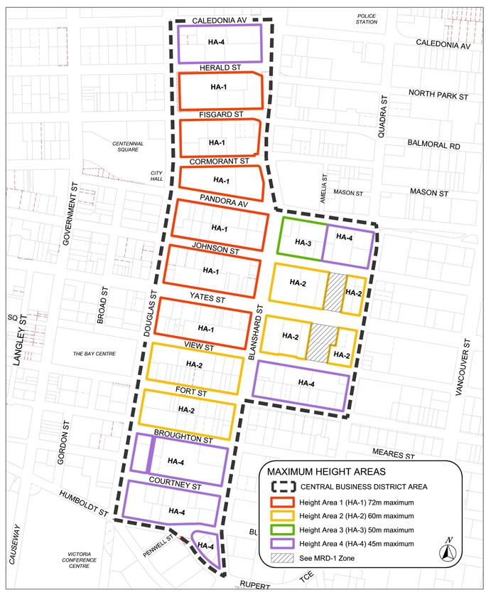
3. Height
a. Height - Maximum: HA-1 HA-2 HA-3 HA-4
72.0m 60.0m 50.0m 45.0m
b. Not withstanding sub section (a), maximum
Height for Buildings or any portion located
within 40m from the Lot Line abutting the
east side of Douglas Street: 45.0m
c. Projections into Height - Maximum:
i. Parapets: 1.0m
ii. Rooftop Structures: 5.0m
CBD-2 Page 25 of 62Part 4 - Zones
4. Setbacks and Projections
a. Front Setback Plane - Minimum
i. Buildings abutting Blanshard, Douglas or Yates street, for any building
portion above 20.0m in Height: 5:1 (Angle of Inclination)
ii. All other Buildings, for any portion above 15.0m in Height: 5:1 (Angle of Inclination)
b. Side and Rear Lot Line Setbacks - Minimum
i. Exterior walls 20.0m tup to 30.0m in Height: 3.0m
ii. Exterior walls over 30.0m and up to 45.0m in Height: 6.0m
iii. Exterior walls over 45.0m in Height: 10.0m
iv. Exterior walls abutting Douglas Street 30.0m or more in Height: 9.0m
c. Projections into Setbacks - Maximum
i. Balconies, cornices, guardrails, fin walls, slab edges, eaves, window
overhangs and sunscreens: 0.6m
ii. Exterior wall treatments, insulation and rainscreen systems: 0.13m
5. Motor Vehicle and Bicycle Parking
a. All motor vehicle and bicycle parking shall be provided in accordance with Part 5 of this bylaw.
b. Notwithstanding the requirements in Part 5 of this bylaw, all motor vehicle parking must be located within a
Building.
6. Lot Coverage and Open Space
(Intentionally left blank)
7. Lot Dimension and Area
(Intentionally left blank)
8. Site Specific Regulations
Column A Column B Column C
Civic and Legal Address Regulations Conditions
1. 1321 Blanshard Street a. Maximum Density of Development:
3.0:1
LOT A OF LOTS 368- b. Maximum Building Height: 43.0m
370, 385-387 VICTORIA, c. Bonus Density of Development for all i. At least 80% of the Floor Area
VIP83640 uses: 5.0:1 is used for Office uses;
ii. The south and west frontages
of any Building on the site
are glazed and used for Retail
Trade or restaurant uses only;
iii. Public art having a value of at
least $100,000 is provided on
the site; and
iv. At least 160 motor vehicle
parking spaces are provided
underground on the site and
at least 125 of the spaces are
made available for general
public use after ordinary office
hours.
CBD-2 Page 26 of 62Part 4 - Zones
Column A Column B Column C
Civic and Legal Address Regulations Conditions
2. 1515 Douglas Street Note: In this subsection, the “Development Areas” are those depicted in the following sketch as DA-A and DA-B:
750 Pandora Ave.
LOT 1 OF LOT 1247,
1248 AND 1257
VICTORIA EPP27886
Development Area – A
(DA-A)
Development Area – B
(DA-B)
Development Area - A a. Maximum Building Height: 29.0m
b. Maximum Density of Development:
2.91:1
c. Maximum Floor Area for Residential
uses: in Development Area DA-A must
not exceed 7,468m2.
d. Up to 258m2 of Floor Area used
for mechanical equipment on the
uppermost Storey of a Building
may be excluded from floor area
calculations.
e. Motor vehicle parking spaces may
be provided on a separate Lot within
Development Area DA-A or DA-B, if the
parking site is charged by a covenant
in favour of the City restricting the use
of the Parking Area and an easement
in favour of the owner who requires the
parking spaces.
f. Maximum Lot Coverage: 78%
g. Bonus Density of Development: 3.7:1 i. At least 140 motor vehicle
parking spaces are provided
underground on the site in
addition to those otherwise
required by Section 7 of this
Part;
ii. At least 34 Bicycle Parking
Long-term spaces and 34
storage lockers for use by
cyclists are provided on the site.
CBD-2 Page 27 of 62Part 4 - Zones
Column A Column B Column C
Civic and Legal Address Regulations Conditions
Development Area - B h. Maximum Building Height: 56.5m
i. Maximum Density of Development
2.86:1
j. Up to 400m2 of Floor Area used
for mechanical equipment on the
uppermost Storey of a Building
may be excluded from Floor Area
calculations.
k. Motor vehicle parking spaces may
be provided on a separate Lot within
Development Area DA-A or DA-B, if the
parking site is charged by a covenant
in favour of the City restricting the use
of the Parking Area and an easement
in favour of the owner who requires the
motor vehicle parking spaces.
l. Maximum Lot Coverage: 61%
m. Bonus Density of Development: i. A public walkway with an
5.88:1 average width of 3.7m and a
minimum width at all points of
3m is constructed on the site to
connect Pandora Avenue and
Cormorant Street, and secured
by a statutory right of way and
covenant in favour of the City.
CBD-2 Page 28 of 62Part 4 - Zones
Column A Column B Column C
Civic and Legal Address Regulations Conditions
3. 1701 Douglas Street/770 a. Maximum Density of Development:
Fisgard Street 3.0:1
b. Maximum Building Height: 43.0m
LOT 1 OF LOTS 692 c. Motor vehicle parking spaces may
TO 696 INCLUSIVE, be provided on a separate Lot within
AND OF LOTS 707 Development Area 1, 2 or 3, if the
TO 711 INCLUSIVE, parking site is charged by a covenant
VICTORIA,EPP3862 in favour of the City restricting the use
of the Parking Area and an easement
(Development Area 1) in favour of the owner who requires the
parking spaces.
d. The only Building setback that is
required is a setback from each of
Herald, Blanshard, Fisgard and Douglas
Streets of 1 cm for each 5cm of building
Height that exceeds 10m.
e. Bonus Density of Development for all i. At least 50% of the Floor Area
uses: 3.26:1 of each development area is
Residential;
ii. A public walkway at least 3.7m
wide is constructed on the
site to connect Herald Street
to Fisgard Street at a point
approximately equidistant from
Douglas and Blanshard Streets,
and secured by a statutory right
of way in favour of the City; and
iii. The owner enters into a housing
agreement with the City
that requires at least 10% of
Dwelling Units on the site to
be adaptable units and that all
Dwelling Units on the site be
available for occupancy under a
residential tenancy agreement.
CBD-2 Page 29 of 62Part 4 - Zones
Column A Column B Column C
Civic and Legal Address Regulations Conditions
4. 780 Fisgard Street a. Maximum Density of Development:
3.0:1
LOT 2 OF LOTS 696 TO b. Maximum Building Height: 43.0m
698 INCLUSIVE, AND c. Motor vehicle parking spaces may
OF LOTS 705 TO 707 be provided on a separate Lot within
INCLUSIVE, VICTORIA Development Area 1, 2 or 3, including
EPP3862 EXCEPT an air space parcel, if the parking site is
PART IN AIR SPACE charged by a covenant in favour of the
EPP38768 City restricting the use of the Parking
Area and an easement in favour of the
(Development Area 2) owner who requires the parking spaces
d. The only Building setback that is
required is a setback from each
of Herald, Blanshard, Fisgard and
Douglas Streets of 1cm for each 5cm of
Building Height that exceeds 10m.
e. Bonus Density of Development: i. At least 50% of the Floor Area
4.88:1 of each development area is
Residential;
ii. A public walkway at least 3.7m
wide is constructed on the
site to connect Herald Street
to Fisgard Street at a point
approximately equidistant from
Douglas and Blanshard Streets,
and secured by a statutory right
of way in favour of the City; and
iii. The owner enters into a
housing agreement with the
City that requires at least 10%
of Dwelling Units on the site
to be adaptable units and that
all dwelling units on the site be
available for occupancy under a
residential tenancy agreement.
CBD-2 Page 30 of 62Part 4 - Zones
Column A Column B Column C
Civic and Legal Address Regulations Conditions
5. 1700 Blanshard Street a. Maximum Density of Development:
3.0:1
LOT A, OF LOTS 699 TO b. Motor vehicle parking spaces may
700 INCLUSIVE, AND be provided on a separate Lot within
OF LOTS 703 TO 707 Development Area 1, 2 or 3, if the
INCLUSIVE, VICTORIA, parking site is charged by a covenant
PLAN 13333, EXCEPT in favour of the City restricting the use
PART IN PLAN EPP3862 of the parking area and an easement
in favour of the owner who requires the
(Development Area 3) parking spaces.
c. The only Building setback that is
required is a setback from each
of Herald, Blanshard, Fisgard and
Douglas Streets of 1cm for each 5cm of
Building Height that exceeds 10m.
d. Bonus Density of Development for all i. At least 50% of the Floor Area
uses: 7.47:1 of each development area is
Residential;
ii. A public walkway at least 3.7m
wide is constructed on the
site to connect Herald Street
to Fisgard Street at a point
approximately equidistant from
Douglas and Blanshard Streets,
and secured by a statutory right
of way in favour of the City; and
iii. The owner enters into a
Housing Agreement with the
City that requires at least 10%
of Dwelling Units on the site to
be adaptable units and that all
Dwelling Units on the site be
available for occupancy under a
residential tenancy agreement.
CBD-2 Page 31 of 62Part 4 - Zones
Column A Column B Column C
Civic and Legal Address Regulations Conditions
6. 1406 Blanshard Street a. Maximum Density of Development:
3.0:1
LOT 2 OF LOTS 147 & b. Maximum Building Height: 43.0m
148, VICTORIA, VIS6683 c. There are no minimum front, side or
rear yard setbacks required
d. Bonus Density of Development for all i. At least 3700m2 of Residential
uses: 6.06:1 Floor Area is provided;
ii. Retail Trade and restaurant
uses only are operated at grade
level;
iii. Landscaped open space
accessible to the public is
provided between the Building
on the site and the adjacent
Streets; and
iv. All motor vehicle parking
spaces other than those
for visitor use are provided
underground.
7. 1810 Blanshard Street a. Maximum Density of Development:
3.0:1
LOT A, OF LOTS b. Maximum Building Height: 43.0m
717-720, VICTORIA, c. The minimum number of off-street
VIP52793 motor vehicle parking spaces for
Residential uses is 0.25 spaces per
Dwelling Unit, and for Office uses is 1
space per 170m2 of Floor Area.
d. Bonus Density of Development for all i. The site has an area of at least
uses: 5.0:1 2,000m2;
ii. No fewer than 80 underground
motor vehicle parking spaces
are provided on the Lot; and
iii. At least 10% of the area of the
Lot adjacent to the intersection
of Blanshard and Herald Streets
is an open plaza to a Height of
at least 5.5m above grade.
CBD-2 Page 32 of 62You can also read