Marlborough, Te Ihu Fire Plan for - Fire and Emergency New Zealand
←
→
Page content transcription
If your browser does not render page correctly, please read the page content below
Fire Plan for
Marlborough, Te Ihu
             2021 –2024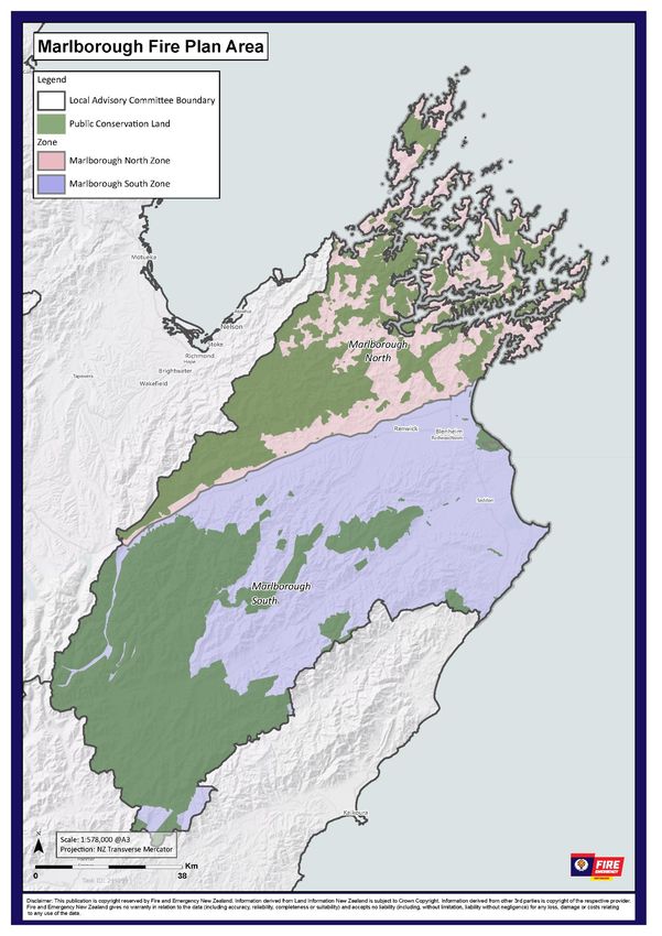
Document Title: Marlborough Fire Plan – Draft for consultation
Published: 23 April 2021
Document review date: June 2021 based on consultation feedback
Status of this document
This document is issued by Fire and Emergency New Zealand.
Recommendations for change
The document, its content and specific processes are not to be altered except through Fire
and Emergency New Zealand document management processes.
Requests or recommendations for changes to this material should be sent to Region
Manager, Te Ihu

© 23 April 2021 Fire and Emergency New Zealand
Fire Plan for - Marlborough

Table of contents
Introduction ........................................................................................................................................................ 3
 Required by legislation ..................................................................................................................................... 3
 Content of the fire plans .................................................................................................................................. 3
 Consultation ..................................................................................................................................................... 4
   Key stakeholders ............................................................................................................................................ 4
 Review and amendment................................................................................................................................... 4
Description of the fire plan area......................................................................................................................... 5
National Framework for Fire Control ................................................................................................................. 8
 Our policies ....................................................................................................................................................... 8
Fire seasons ........................................................................................................................................................ 9
 Trigger thresholds for changing fire seasons ................................................................................................... 9
Prohibiting fires in the open air (section 52) ....................................................................................................10
 Trigger thresholds for prohibiting fires in the open air under section 52 ......................................................10
Restricting and prohibiting activities (section 52) ............................................................................................10
 Trigger thresholds for restricting or prohibiting activities under section 52 .................................................11
 Activities and risk mitigation ..........................................................................................................................11
  Forestry operations ......................................................................................................................................11
  Activities in rural areas .................................................................................................................................11
Communicating changes in fire seasons and restrictions or prohibitions .......................................................12
Fire permits.......................................................................................................................................................12
   Council bylaws, regional plans, legal covenants or restrictions ...................................................................12
   When a permit is needed .............................................................................................................................13
   Fire types ......................................................................................................................................................13
   Permits in prohibited fire seasons or during prohibitions under Section 52 ...............................................14
Fire breaks ........................................................................................................................................................14
Fire hazard removal ..........................................................................................................................................14
   Reporting fire hazards ..................................................................................................................................14
   Assessment of fire hazards ...........................................................................................................................15
   Outcomes from the assessment...................................................................................................................15
   Fire hazard removal notice (section 65) .......................................................................................................15
   Imminent danger notice (section 68) ...........................................................................................................16
Compliance and enforcement ..........................................................................................................................16
 Fire and Emergency’s role ..............................................................................................................................16
Contact us .........................................................................................................................................................16
Appendix 1 – Schedule of stakeholders ...........................................................................................................17
 National level stakeholders ............................................................................................................................17
 Area - level stakeholders ................................................................................................................................19
Appendix 2 - Zone information.........................................................................................................................21
 Zone A – Marlborough North .........................................................................................................................21
 Zone B – Marlborough South .........................................................................................................................26
 Public conservation land ................................................................................................................................32
Glossary ............................................................................................................................................................34

23 April 2021                                                                                                                                                        1
Fire Plan for - Marlborough

Document drafting information

 Owner                    Region Manager – Te Ihu
 Steward                  District Manager – Nelson Marlborough
 Last reviewed            22/04/2021
 Review period            Every three years

Record of amendments
 Version         Date            Author             Brief description of amendment
 V0.1            March 2021      Chris Hayles       Initial Draft
 V0.2            April 2021      Kerry Stewart      Technical writers review
 V0.3            April 29021     Chris Hayles       Review updates
 V0.4            22 April 2021   Kerry Stewart      eviewed and prepared for public consultation

Document review and consultation
 Name                               Title                         Business Area            Date
                                                                                           [Date]

Approval
Approved and issued on [date].

 Full Name: Paul Henderson
 Title: Region Manager
 Date: 16 April 2021

                                                                     Signature

Add another block of other signatures as required

23 April 2021                                                                                                 2
Fire Plan for - Marlborough

Introduction
Required by legislation
Fire plans are required by section 22 of the Fire and Emergency New Zealand Act 2017 and the Fire and
Emergency New Zealand (Fire Plans) Regulations 2018.
According to Regulation 5 of the Regulations, the purpose of a fire plan is to:
•   provide transparency and predictability in relation to the use Fire and Emergency’s fire control powers
    under sections 52 to 58 and 62 to 68 of the Fire and Emergency New Zealand Act 2017 in each local
    area; and
•   ensure that the particular fire risk conditions in each local area are considered by Fire and Emergency
    when it establishes policies and procedures for, and exercises fire control powers within, that local
    area.
This means that we must explain how we set locally-appropriate triggers for changing fire seasons for
outdoor fires to require permits, or to prohibit fires and even restrict activities that may cause unwanted
fires. This helps people to understand what to expect, how to plan for this and what they need to do to
comply with any requirements.
We need to take into account the local fire risk conditions, and not just apply a blanket standard across the
country, as all of our areas have different levels of risk, so what may be appropriate for one area of the
country may not be suitable somewhere else.

Content of the fire plans
Fire plans must:
•   describe the particular fire risk conditions that exist or are likely to exist in the local area. This means
    that each fire plan is accurate and relevant for its area, and the fire plan can be broken down into
    specific zones within the area where fire risk conditions or control measures differ.
•   set out the policy for fire control in the local area. This sets out when and why we restrict or prohibit
    fires in the outdoors, or restrict activities that may cause unwanted fires.
•   set out the procedures to be followed for fire control in the local area, including details of the
    processes that Fire and Emergency will follow, and the factors that Fire and Emergency will consider,
    when deciding to:
    o issue notices of prohibitions or restrictions for fire control under section 52 of the Act
    o declare a prohibited or restricted fire season in relation to the local area, or a part of that area,
        under section 56 of the Act
    o issue notices in relation to firebreaks under section 62 of the Act
    o issue notices to remove or destroy vegetation or other things on land under section 65 of the Act.
    This means that our communities understand how we have come to those decisions, and that we can
    show that they are evidence-based decisions that don’t impact on recreational and economic activities
    unnecessarily.
A fire plan must be consistent with:
•   Fire and Emergency’s national strategy
•   any local planning by Fire and Emergency in respect of the local area
•   any current operational service agreement and memorandum of understanding that Fire and
    Emergency has with other agencies or people relevant to the local area
•   any relevant Fire and Emergency policies.
A fire plan must cover the entire local area that it relates to, but we can break each area down into smaller
zones to manage them individually. This ensures that each fire plan is relevant to everywhere within its
area.

23 April 2021                                                                                                      3
Fire Plan for - Marlborough

Fire plans are not about how we fight fires in the local area, or the resources available to do so. This plan is
about how, when and why Fire and Emergency will exercise its fire control powers to reduce the incidence
of unwanted fires in the area.

Consultation
Before issuing a fire plan for a local area, or an amended fire plan, Fire and Emergency must:
•   publish a notice that:
    o gives an overview of the content of the proposed plan
    o states where you can see and read a copy of the plan
    o specifies how you can make a submission on the plan and where to send your submissions
    o specifies the closing date and time for submissions
•   consider every submission received by the closing date and time for submissions.
This notice must be published in the Gazette, or in a newspaper circulating in the local area, or a website.

Key stakeholders
A list of those key stakeholder involved in the creation of the plan, its maintenance and relevant decision
making is included as the stakeholder schedule in the appendices of the plan.

Review and amendment
Fire and Emergency may amend a fire plan at any time, but we must review the fire plan for each local area
at least once every 3 years, or if there are significant changes to the boundaries of the local area.
When we review the fire plan for a local area, we must confirm that the fire plan remains appropriate for
that area; or amend the fire plan, as necessary, and consult on changes.

23 April 2021                                                                                                      4
Fire Plan for - Marlborough
Description of the fire plan area
Overview of whole area
Geography The Marlborough Fire Plan consists of all the lands within the boundaries of the
Marlborough District Council Unitary Authority. This includes all privately owned
and publicly managed lands within the plan boundaries excluding the Defence land
at Royal New Zealand Air Force (RNZAF) Base Woodbourne.
The plan covers all land, and islands, encompassing the Marlborough Sounds area
to the North, and borders the Nelson/Tasman District to the West, starting at Cape
Soucis (Raetihi), travelling through the Rai Saddle and the Bryant and Richmond
Ranges before crossing State Highway 63 near the Rainbow Road turnoff. It follows
the St Arnaud Range to the South and begins to border the North Canterbury
District near the head waters of the Clarence River. It follows the Crimea, Amuri
and Inland Kaikoura Ranges before meeting the East Coast below the settlement of
Wharenui.
The Marlborough District covers 12,482 square kilometres.
Demographics At Fire and Emergency New Zealand, we have an in-depth knowledge of the
demographics for each of the communities we serve. These demographics help us
to understand the type of support each of our communities might need and how
we communicate with them.
We use this knowledge in all aspects of our work, including our delivery of the 4Rs
of emergency management and for fire control measures, such as declaring the
beginning and end of fire seasons, prohibiting and restricting the use fire, and
issuing fire permits.
Statistics New Zealand estimates the population at 50,200 as of June 2020. The
region is home to 1.0% of New Zealand's population.
Marlborough has three towns with a population over 1000. Together they are
home to 70.6% of the region’s population.
Population
Urban area % of region
(June 2020)
Blenheim 28,200 56.2%
Picton 4,730 9.4%
Renwick 2,530 5.0%
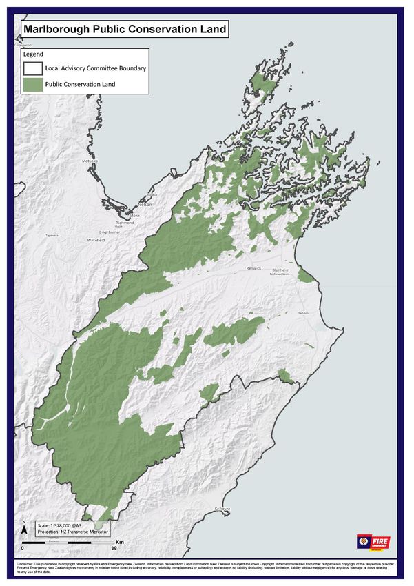
Zones Because the different fire risk conditions that exist in different parts of the fire plan
area, the area is divided into a number of different fire season zones to allow for
appropriate fire control measures to be applied locally:
• Zone A – Marlborough North
• Zone B – Marlborough South
• Public conservation land
23 April 2021 5Fire Plan for - Marlborough
NZ Defence Force Within the Marlborough local area, activities in the following defence areas are
subject to New Zealand Defence Force fire control powers, including fire permit
requirements:
• Woodbourne Airbase
Activities in other parts of the Marlborough local area are subject to Fire and
Emergency’s fire control powers, including fire permit requirements.
Further information about the boundaries of the defence area(s) and applicable
fire controls is available through https://www.nzdf.mil.nz/nzdf/contact-us/ .
Frequency of On average, this area experiences:
elevated fire
• 44 days of extreme fire danger (4-year average using Mid Awatere RAWS)
danger
• 42 days of very high fire danger (4-year average using Mid Awatere RAWS)
23 April 2021 6Fire Plan for - Marlborough 23 April 2021 7
Fire Plan for - Marlborough

National Framework for Fire Control
The National Framework for Fire Control consists of policies, procedures and tools that enable Fire and
Emergency to manage fires – using fires where appropriate and restricting or prohibiting them when there
is a risk of unwanted fire. These all resolve in the Checkitsalright.nz website, the fire permit application
system with additional information on our public webpage.
Fire and Emergency has a number of statutory fire control powers that can be applied to help reduce risk,
as follows:
•   Setting fire seasons
•   Prohibiting fire in open air or revoking the prohibition
•   Prohibiting or restricting other activities or revoking the prohibition or restriction
•   Fire permitting
•   Control of fire breaks
•   Fire hazard management

Our policies
The current internal-use policies and associated supporting processes that guide our decisions and actions
are:
Fire seasons, prohibitions and restrictions policy, relating to sections 52 to 58 of the Act and decisions to:
•   declare or revoke a prohibited or restricted fire season
•   prohibit fire in open air or revoke a prohibition
•   prohibit or restrict activities that may cause a fire to start or spread, and revoke prohibition or
    restriction.
Fire permitting policy, supporting the policy above and also defining actions for:
•   supporting a member of the public who is applying for a fire permit
•   assessing a fire permit application
•   granting or renewing a fire permit
•   refusing to grant or renew a fire permit
•   suspending or cancelling a fire permit
•   operational decisions when responding to an alarm of fire in open air.
Fire hazard removal policy, relating to sections 65 to 67 of the Act and decisions about what to do when:
•   a potential fire hazard is reported to Fire and Emergency
•   we are assessing a potential fire hazard
•   we arrange for the removal or destruction of a confirmed fire hazard.
Compliance and enforcement policy, covering how we monitor and take action to identify and influence
landowners and others to comply with the requirements of the Act and other relevant legislation. This
covers activities which:
•   reduce harm from unwanted fire
•   support the safe use fire as a land management tool and reduce harm if fire escapes control
•   minimise avoidance of the Fire Emergency levy
•   reduce non-compliance with any legislation or regulations under which Fire and Emergency New
    Zealand has a compliance function.
Note: work is also under way to define policy and guidance for both internal and stakeholder audiences,
covering:

23 April 2021                                                                                                    8
Fire Plan for - Marlborough
Fire breaks- relating to sections 62 to 64 of the Act to support decisions and actions relating to
requirements for landholders to:
• make and clear any firebreak on the landholder’s land:
• remove any vegetation or other thing from an existing firebreak.
Fire seasons
Fire seasons are used to inform people about the requirements for or restrictions on lighting fires in the
open air, and to limit the use fire to protect communities from the consequences of unwanted fire.
Fire and Emergency can declare or revoke a prohibited or restricted fire season in an area, and uses its Fire
seasons, prohibitions and restrictions policy and associated processes to manage this.
Fire seasons are applied to geographic zones based on:
• the fire environment (fuel types, curing, weather, topography, historic trends)
• fire climatic zones
• topographical boundaries/features (rivers, roads, coast lines, forest and national park boundaries).
• fire control considerations.
One of three types of fire season is in force at any time in an area or zone:
Open fire season Fires may be lit in open air, without restriction.
Applies whenever there is not a prohibited or
restricted fire season in place.
Restricted fire Lighting a fire is riskier than usual. A fire permit is
season required and may also have specific conditions to
make sure fires can be safely lit and remain under
control.
Prohibited fire Lighting fires in the open air is not permitted. Existing
season fire permits are suspended. However, fire permits
may still be granted in exceptional circumstances (see
Error! Reference source not found.).
Changes to fire seasons are publically notified, including by publishing details on Fire and Emergency’s
website and social media.
It is important that stakeholders know what the current fire season is, and understand how they can
comply with the requirements.
To see what the current fire season is within a local area (or zone within an area) go to checkitsalright.nz.
Trigger thresholds for changing fire seasons
In consultation with stakeholders, the following Fire Weather System triggers have been set for declaring
restricted and prohibited fire seasons within the fire plan area or fire permit zone within that area. The
trigger thresholds identify when prevailing weather conditions create ongoing potential for problem fires.
The trigger thresholds make use:
23 April 2021 9Fire Plan for - Marlborough
• the Remote Automatic Weather Station (RAWS) climatology data for the fire plan area or zone.
• historical fire data for the fire plan area or zone.
Other factors such as resource availability, other emergency events etc., may also feed into a decision to
declare or revoke a fire season.
Forecast weather trends must be taken into consideration when declaring a change in fire season. An
upcoming rain event may defer a change in season, or forecast dry weather and strong winds may indicate
a need to change season days before the trigger threshold would otherwise be reached.
Prohibiting fires in the open air (section 52)
There are times when Fire and Emergency may need to prohibit fires in the open air, outside of the usual
fire season changes. This control is used in extreme circumstances, for example when:
• large or multiple incidents occur that put firefighting resources under strain, e.g. Port Hills fire
• extreme fire weather conditions occur during a restricted fire season, e.g. strong dry winds, high
temperatures associated with very low humidity
• emergency events occur, e.g. the rupture of the Marsden Point fuel pipeline, increasing the fire hazard
in a specific area.
We can only prohibit fires in the open air when fire risk conditions exist or are likely to exist in the area, and
the prohibition or restriction is necessary or desirable for fire control.
Fire and Emergency may also prohibit fires in the open air while the Epidemic Preparedness (COVID-19)
Notice 2020 is in force, without needing to consider fire risk conditions or other factors. This might happen
if our response capabilities are affected by COVID, and we aren’t able to respond effectively if there is an
unwanted fire.
Trigger thresholds for prohibiting fires in the open air under section 52
There are no specific thresholds in Marlborough for prohibiting fires in the open air under Section 52 of the
Act.
Restricting and prohibiting activities (section 52)
There are times when fire risk conditions are such that certain activities may cause a fire to start or spread.
Examples of these activities include but are not limited to:
• roadside mowing
• cutting or welding operations that involve the use portable gas, disc grinder or arc welding equipment
that produces sparks, flames or heat, generally known as ‘hot works’
• chainsaw thinning to waste/tree felling
• mowing, ploughing or harrowing fields
• use fireworks.
Section 52 of the Act allows us to prohibit or restrict one or more activities in an area or areas, when our
assessment is that:
• the activity, (including access to an area) may cause a fire to start or spread and adequate controls are
not available,
• fire risk conditions exist or are likely to exist in the area,
• the prohibition or restriction is necessary or desirable for fire control purposes,
• there’s an inability to adequately mitigate the assessed risk.
Prohibition or restriction means:
23 April 2021 10Fire Plan for - Marlborough
When an activity is… It means the activity…
Prohibited must not be undertaken at all by any person while the prohibition is in effect (except
if it is an excluded activity that relates to the carrying out of essential services in the
area).
Restricted can be undertaken subject to certain conditions, such as restrictions on:
• the times of the day
• the manner in which it is undertaken.
If we have restricted or prohibited access to a location under Section 52, we can’t prevent someone who
lives or works in the location from entering, nor prevent someone from carrying out essential services
there.
Trigger thresholds for restricting or prohibiting activities under section 52
There are no specific thresholds in Marlborough for restricting or prohibiting activities under Section 52 of
the Act.
Activities and risk mitigation
The following activities are known to have caused fires in this area under increased fire risk conditions.
Guidance information for mitigating the risk from these activities is included where available.
Further information about mitigating the risk of activities and other fire safety tips can be found on
checkitsalright.nz.
Forestry operations
Since 2003 forest owners and contractors have been collaborating with the Fire Authority /Fire and
Emergency to produce a ‘Forest Fire Risk Management Guideline’ document that is now on its 12th
iteration. The guideline details the equipment and activity requirements for each aspect of forest
operations across six levels of fire risk.
The Build Up Index (BUI) and the Fire Weather Index (FWI) are used as the trigger levels. Each risk level is
represented by a colour similar to the half grapefruit ‘Fire Danger Today signs. Once the BUI climbs above
40, a daily update of fire risk level or ‘colour’ for each forest zone is emailed out to a list of 350 industry
people and organisations. This is done around 9:00am daily, with today and tomorrow forecast risk level
given. At 10am the levels are broadcast over the forest radio channels from the Richmond Hill fire lookout.
Forest Fire Risk Management Guidelines contain advice on mitigating the risks.
Activities in rural areas
Roadside mowing
Roadside mowing contractors are aware of the hot work fire weather indices and monitor them during high
fire danger times. They will generally cease roadside mowing when conditions get extreme.
Mowing, ploughing or harrowing fields
Local landowners are aware that spark producing activities need to be carefully managed during times of
increased fire risk. Mitigation measures such as not mowing, ploughing or harrowing during the heat of the
day or on windy days are applied. Consideration is also given on using vehicles in long dry grass paddocks.
Hot work fire weather indices can be used for extra mitigation measures.
Hot works
Local industry is aware that spark producing activities need to be carefully managed during times of
increased fire risk. Mitigation measures such as not welding, grinding, gas cutting during the heat of the day
23 April 2021 11Fire Plan for - Marlborough
or on windy days are applied. Patrolling areas after hot works activities is often undertaken. Hot work fire
weather indices can be used for extra mitigation measures.
Hotwork Fire Weather Indices
Powerline auto-reclosures
In 2015 the Power line auto- reclosure was guideline was developed in consultation with local power
network distributors. The guideline is based on the risk level being calculated on a matrix of Grass Curing
V’s Fine Fuel Moisture Code with a wind component to give a 3-colour risk level that indicates if the auto
reclose should be switched off.
Powerline Fire Weather Indices
Communicating changes in fire seasons and restrictions or prohibitions
It’s important that people planning to light fires in the open air know whether they can do so safely and
legally, so they need to know what the current fire season is in the area, whether any other prohibition
applies, and whether a permit is required.
Fire season changes, and restrictions and prohibitions under section 52 of the Act, are publicly notified to
our communities, stakeholders and partners in a number of ways.
Modes of communication include, but are not limited to:
• Direct contact with our partners and stakeholders, including email
• Social media
• Email and text directly to permit holders
• Check It’s Alright website https://www.checkitsalright.nz or 0800 336 942
• Fire sign management – these are changed to reflect season status with additions of “Fire Permit
required” or “Total fire ban”.
Fire permits
The information included with a fire permit helps people understand how to light a fire safely, and to
reduce the risk of their fire burning out of control. Fire permits carry conditions which vary based on the
current local fire risk conditions.
Fire risk conditions vary by time and other factors such as fuel and topography, so the acceptable
conditions for burning are set for each fire permit.
Fire permits may also be suspended or cancelled in certain circumstances, such as: where fire risk
conditions change, for fire control purposes, or as fire seasons change/prohibitions are imposed.
Council bylaws, regional plans, legal covenants or restrictions
No matter the current fire season, council bylaws and regional plan rules relating to smoke and air pollution
must also be followed, even if Fire and Emergency has issued a fire permit.
There may also be legal covenants or restrictions which restrict the ability to light a fire in some areas,
regardless of the fire season. For example, if there are power pylons or other infrastructure nearby.
Therefore, even if you don’t need a permit, you may not be able to light fires in some places.
You will also need landowner or occupier approval before lighting a fire, even if Fire and Emergency has
issued a fire permit.
23 April 2021 12Fire Plan for - Marlborough
When a permit is needed
The need for a fire permit is based on:
• type of fire
• the fire season or restrictions or prohibitions on fires in the open air.
Fire types
Some fire types may be allowed in restricted and prohibited fire seasons by making them:
• Authorised (no permit required)
• Permit required
For more information on fire types, see Open air fires – rules and permits on the Fire and Emergency
website www.fireandemergency.nz.
Authorised fire types in a restricted fire season
Authorised fire types in a restricted fire season, i.e. those fire types not requiring a fire permit because they
are not ‘fires in open air’, include:
• gas-operated appliances
• charcoal barbeques or grills
• wood-fire pizza oven
• chiminea
• cultural fires
• braziers
• fire pits/bowls
• open drum and manufactured incinerators.
Authorised fire types on public conservation land in a restricted fire season
Department of Conservation says that fires may be lit only in designated permanent Department of
Conservation fireplaces at overnight campsites or amenity areas, and only when there is no prohibition in
place.
You can light campfires for cooking and warmth in the backcountry (areas that are over an hour's walk from
the nearest road end) only if:
• there is no fire ban in place, and
• there are no notices prohibiting fires there, and
• the fire is at least 3 metres away from trees and anything that could catch fire, and
• the fire is smaller than 0.5 m in width and in height.
For information about fires that can be lit on public conservation land, visit https://www.doc.govt.nz/our-
work/fire/
Authorised fire types in a prohibited fire season
Authorised fire types in a prohibited fire season, i.e. those fire types not requiring a fire permit because
they are not ‘fires in open air’, include:
• gas-operated appliances
• charcoal barbeques or grills
• wood-fire pizza oven
• chiminea
23 April 2021 13Fire Plan for - Marlborough • cultural fires. Authorised fire types on public conservation land in a prohibited fire season Department of Conservation says that the only authorised fire type on public conservation land (PCL) in a prohibited fire season, i.e. a fire type not requiring a fire permit because it is not a ‘fire in open air’, is gas- operated appliances. Permits in prohibited fire seasons or during prohibitions under Section 52 Fire and Emergency may grant permits during a prohibited fire season, or when there is a prohibition under section 52 of the Act, when the fire or activity is necessary to prevent, reduce, or overcome any hazard to life or because any other serious emergency. We may grant fire permits during a prohibited fire season if weather or other conditions have temporarily reduced the fire hazard, so as to make it apparently safe to light a fire. Permits issued in a prohibited fire season (e.g. for biosecurity reasons) remain active when the fire season changes. Fire breaks Fire and Emergency has the authority under Section 62 of the Fire and Emergency New Zealand Act 2017 to require landholders to make or clear firebreaks on the landholder’s land, or keep them clear, if we think it’s needed for fire control. We will work with affected landholders on a case-by-case basis, and try to reach a voluntary solution before we would use our powers to require firebreaks. Further guidance has not yet been developed, so each situation would be dealt with individually. Fire hazard removal If Fire and Emergency reasonably consider that vegetation, or some other thing, is a fire hazard, meaning that it likely to endanger people or property by increasing the risk of outbreak or spread of fire, we can require that vegetation or thing to be removed or destroyed. We will work with you to fix the issue first, but Fire and Emergency has the authority under section 65 of the Fire and Emergency New Zealand Act 2017 to legally require you to do it. You then have 1 month to fix the problem, although you can appeal against the requirement. Any appeal must be made within 14 days and will be handled through Fire and Emergency’s dispute resolution scheme. Our fire hazard removal powers apply to land, but not to anything on or inside a building. Local councils have the authority to address fire risk related to buildings, such as hoarding. If it’s urgent (an imminent threat) we can tell you and fix the problem ourselves immediately in order to keep people and property safe. Reporting fire hazards Anyone who becomes aware of a fire hazard or is worried about the potential of something being a fire hazard can report it to Fire and Emergency – see Submit a Fire Hazard Assessment Request at www.fireandemergency.nz/at-home/fire-hazards-in-your-community/ for the Potential Fire Hazard Advice form. 23 April 2021 14
Fire Plan for - Marlborough

Assessment of fire hazards
Fire and Emergency will assess whether there is a potential for the fuel to cause harm or damage to people
or property if a fire starts. We will assess the likelihood of a fire starting and the consequences in terms of
risk to human life, structures and other values.
We will not enter a property (apart from going to the front door) without permission from the occupier.
If permission is not granted or an occupier cannot be located, we will assess the potential fire hazard from
outside of the property or speak with the occupier of the neighbouring property to request access to better
view the potential fire hazard.
If we need to, a Fire and Emergency inspector can enter and inspect land that is not a home or marae (or a
building associated with a marae) in order to determine whether certain materials (including timber, dry
plant cuttings and ‘other flammable material’) are being stored outside a building in a way the creates a fire
hazard to the building, another building, or to any road or other public place (see regulation 13(4) of the
Fire and Emergency New Zealand (Fire Safety, Evacuation Procedures, and Evacuation Schemes)
Regulations 2018).
A Fire and Emergency inspector must obtain a warrant to enter and inspect land that is a home or marae
(or a building associated with a marae).
We can take photographs of private land (or things on private land) from public land, so long as we don’t
take pictures of an area or thing that a person can reasonably expect to be private (e.g. a photo that
includes a view into a shower or a secluded area where someone is sunbathing).

Outcomes from the assessment
The assessment will recommend one of the following courses of action:
1. No further action, because the vegetation or other thing does not present a fire hazard. The matter may
be referred to another agency such as the local council if appropriate, e.g. hoarding or vermin infestation.
2. Providing education and information to the occupier or owner of the land, and/or to the complainant, on
how to mitigate any risks from fire, where the notice threshold has not been reached but the assessment
indicates that proactive action would be helpful.
3. Providing the occupier or owner with the opportunity to voluntarily mitigate the risk within an
appropriate time period, as the threshold for issuing a Fire hazard removal notice (s 65) has been met. If
they won’t do this voluntarily, we will issue a Fire hazard removal notice (s 65) to the occupier or owner of
the land. The notice gives them one month to remove or destroy the vegetation or other thing increasing
the risk of the outbreak or spread of fire.
4. Providing verbal notice to the owner or occupier of the land that we are taking immediate action to
remove or destroy any vegetation or other thing on the land, that is a source of imminent danger, under s
68. This power would only be used where there is an ‘almost certain’ likelihood of a fire starting or
spreading at any moment, which would put life or property at risk. Note: This power will be used very
rarely.

Fire hazard removal notice (section 65)
Fire hazard removal notice (s 65) is formal written notification under s 65 of the Act to an occupier or
owner of land that they must remove or destroy the ‘vegetation or other thing’ that has been assessed as
meeting the threshold for issuing a notice.
The notice:
•   describes the vegetation or other thing that must be removed or destroyed, including a map if
    practicable identifying the specific location or extent of the vegetation or other thing
•   explains the risk that Fire and Emergency reasonably considers that the vegetation or other thing
    presents

23 April 2021                                                                                                 15
Fire Plan for - Marlborough
• specifies the actions that must be taken to mitigate the fire hazard risk, e.g. how much vegetation must
be removed or destroyed.
We will always give the occupier or owner the opportunity to fix the issue voluntarily, before we go with
issuing a notice.
The occupier of the land where the fire hazard is located is primarily responsible for its removal or
destruction. If the land is unoccupied, then the responsibility passes to the owner of the land.
Occupier, in relation to any place or land, means any person in lawful occupation of that place or land; and
includes any employee or other person acting under the authority of any person in lawful occupation of
that place or land.
Imminent danger notice (section 68)
An Imminent danger notice is verbal notification under s 68 of the Act to an occupier or owner of land that
Fire and Emergency is going to enter the land and remove or destroy any vegetation or other thing on land
that we consider is a source of imminent danger from fire to life, property, or any road.
Anyone receiving the verbal notice should be able to understand:
• that Fire and Emergency has decided that [description of fire hazard] is a source of imminent danger to
[life, property, and/or road]
• why the fire hazard is a source of imminent danger
• that Fire and Emergency has arranged for the [removal or destruction] of the fire hazard under s 68 of
the Act by [name of contractor] on [date]
• any arrangements for the storage of items removed from the land, and the terms under which the
owner/occupier can retrieve those items.
In the event of an actual fire, our powers to deal with an emergency take effect.
Compliance and enforcement
Fire and Emergency’s role
The Act gives Fire and Emergency compliance and enforcement responsibilities, and powers to support
interventions in cases of non-compliance. In line with this, we have developed a comprehensive Risk
Reduction Strategy, supported by a Compliance and enforcement policy.
Compliance activities generally focus on education and awareness, followed by issuing warnings. If
compliance is still an issue, then more formal enforcement powers may be used.
Where there are cases of serious or repeated non-compliance, Fire and Emergency may use infringement
notices or prosecute. For more information on Fire and Emergency’s compliance and enforcement policies
and procedures and other relevant topics, visit www.fireandemergency.nz/about-us/compliance-and-
enforcement/
Contact us
Firepermit.marlboroughkaikoura@fireandemergency.nz
23 April 2021 16Fire Plan for - Marlborough
Appendix 1 – Schedule of stakeholders
This schedule of stakeholder includes those who should be involved in the creation of these fire plan and their amendments or consulted before making use the
powers of section 52 of the Fire and Emergency New Zealand Act 2017 or notified when this happens. Zone-level stakeholders are listed with each zone’s
description and triggers in Appendix 2.
National level stakeholders
Stakeholder Fire plan development Fire plan amendment Changing fire season to Section 52 fire Section 52
prohibited prohibitions restrictions/prohibition
s on activities
Department of Conservation
NZ Defence Force
Environmental Protection Authority
Federated Farmers NZ
Land Information NZ
Taituarā - Local Govt Professionals
Aotearoa (SOLGM)
Local Government NZ
Forest Owners Association
NZ Farm Forestry Association
Te Uru Rākau
Crown Forestry
NZ Manuka Group
Ministry for Primary Industries
Te Puni Kōkiri
Ngā Whenua Rāhui
Apiculture New Zealand
23 April 2021 17Fire Plan for - Marlborough
Stakeholder Fire plan development Fire plan amendment Changing fire season to Section 52 fire Section 52
prohibited prohibitions restrictions/prohibition
s on activities
Fish and Game
Waka Kotahi NZ Transport Agency
Dairy New Zealand
Ministry of Education
New Zealand Police
23 April 2021 18Fire Plan for - Marlborough
Area - level stakeholders
Stakeholders that need to be involved in fire plans:
Stakeholder Fire plan Fire plan Changing fire Section 52 fire Section 52
development amendment season to prohibitions restrictions/prohibitions
prohibited on activities
Department of Conservation Consult while Consult while Consult during
Notify of decision Notify of decision
creating plan amending plan decision making
Ngāti Tama ki Te Tau Ihu Consult while Consult while
Notify of decision Notify of decision Notify of decision
creating plan amending plan
Te Ātiawa o Te Waka-a-Māui Consult while Consult while
Notify of decision Notify of decision Notify of decision
creating plan amending plan
Ngāti Rārua Consult while Consult while
Notify of decision Notify of decision Notify of decision
creating plan amending plan
Ngāti Kōata Consult while Consult while
Notify of decision Notify of decision Notify of decision
creating plan amending plan
Ngāti Toa Rangatira Consult while Consult while
Notify of decision Notify of decision Notify of decision
creating plan amending plan
Ngāti Kuia Consult while Consult while
Notify of decision Notify of decision Notify of decision
creating plan amending plan
Ngāti Apa ki te Rā Tō Consult while Consult while
Notify of decision Notify of decision Notify of decision
creating plan amending plan
NZ Defence Force Consult while Consult while
Notify of decision Notify of decision Notify of decision
creating plan amending plan
Marlborough District Council Consult while Consult while
Notify of decision Notify of decision Notify of decision
creating plan amending plan
Marlborough Forest Industry Association Consult while Consult while
Notify of decision Notify of decision Notify of decision
creating plan amending plan
OneFortyOne Plantations Ltd Consult while Consult while
Notify of decision Notify of decision Notify of decision
creating plan amending plan
23 April 2021 19Fire Plan for - Marlborough
Stakeholder Fire plan Fire plan Changing fire Section 52 fire Section 52
development amendment season to prohibitions restrictions/prohibitions
prohibited on activities
Department of Conservation Consult while Consult while Consult during
Notify of decision Notify of decision
creating plan amending plan decision making
Ngāti Tama ki Te Tau Ihu Consult while Consult while
Notify of decision Notify of decision Notify of decision
creating plan amending plan
Te Ātiawa o Te Waka-a-Māui Consult while Consult while
Notify of decision Notify of decision Notify of decision
creating plan amending plan
Ngāti Rārua Consult while Consult while
Notify of decision Notify of decision Notify of decision
creating plan amending plan
Ngāti Kōata Consult while Consult while
Notify of decision Notify of decision Notify of decision
creating plan amending plan
Ngāti Toa Rangatira Consult while Consult while
Notify of decision Notify of decision Notify of decision
creating plan amending plan
Ngāti Kuia Consult while Consult while
Notify of decision Notify of decision Notify of decision
creating plan amending plan
Ngāti Apa ki te Rā Tō Consult while Consult while
Notify of decision Notify of decision Notify of decision
creating plan amending plan
Earnslaw One Limited Consult while Consult while
Notify of decision Notify of decision Notify of decision
creating plan amending plan
SCFNZ Limited Consult while Consult while
Notify of decision Notify of decision Notify of decision
creating plan amending plan
PF Olsen Limited Consult while Consult while
Notify of decision Notify of decision Notify of decision
creating plan amending plan
M&R Forestland Management Limited Consult while Consult while
Notify of decision Notify of decision Notify of decision
creating plan amending plan
Federated Farmers Consult while Consult while
Notify of decision Notify of decision Notify of decision
creating plan amending plan
Public Public Public Notify via normal Notify via normal Notify via normal
consultation consultation channels channels channels
23 April 2021 20Fire Plan for - Marlborough
Appendix 2 - Zone information
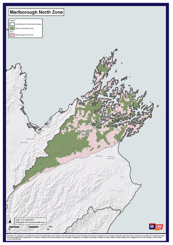
Zone A – Marlborough North
Geography The Marlborough North Zone encompasses all land and islands, including
Department of Conservation (DOC) land, to the North of the Wairau River excluding
the flat land from the Eastern side of State Highway 1 from Tuamarina to Rarangi.
The fire permit zones that make up the Marlborough North zone include
Marlborough North Urban and Marlborough North Rural.
Demographics At Fire and Emergency New Zealand, we have an in-depth knowledge of the
demographics for each of the communities we serve. These demographics help us to
understand the type of support each of our communities might need and how we
communicate with them.
We use this knowledge in all aspects of our work, including our delivery of the 4Rs of
emergency management and for fire control measures, such as declaring the
beginning and end of fire seasons, prohibiting and restricting the use fire, and issuing
fire permits.
Within the Marlborough North zone there is one small urban area being Picton
(population 4730), along with the following rural settlements:
• Havelock – population 630
• Tuamarina – population 240
• Rai Valley – population 190
• Anakiwa – population 180
• Okiwi Bay – population 70
• Ngakuta Bay – population 60
Climate/weather The Marlborough region has a temperate oceanic climate with warm summers, cool
winters, and rainfall distributed across the year.
The Marlborough North zone has a mild climate which is generally warm and
temperate. Rainfall in this zone is significant, with precipitation even during the
driest months. Although annual rainfall in this zone is approximately 1000mm per
year, some areas in the Marlborough Sounds can receive in excess of 1500mm per
year.
Wind is predominantly from the north at an average of 9.5 months per year. Wind
from the west averages 1.5 months and from the south averages 1 month per year.
Land cover/land Land cover in this zone is predominantly DOC managed indigenous forest with small
use amounts of scrub and grass land. There are scattered patches of wilding pines. DOC
manage approximately 70 percent of land in this zone.
Private land in this zone consists of predominantly production forest, both high and
low producing grassland, indigenous forest and scrub fuels. There is a higher
percentage of indigenous forest and scrub fuels in the Marlborough Sounds area,
whilst production forest is predominately in the Southern part of the zone along the
Northbank and Port Underwood areas.
23 April 2021 21Fire Plan for - Marlborough
Land usage within the zone, on the flat ground and rolling hills, is predominantly
dairy, sheep and beef farming with a small amount being in vineyards. Production
forest covers approx. 40,000 ha
Industry Industry Contributes to Affected by use Needs to be
increased risk fire control protected by
of fire in high measures using fire
risk conditions control
measures
Multiple farms in the Koromiko, ☒ ☒ ☐
Havelock, Linkwater, Rai Valley and
Marlborough Sounds areas
One-Forty-One Plantations Limited ☒ ☒ ☒
– Wairau Northbank, Manuka
Island, Linkwater, Wakamarina,
Opouri Valley, Storeys Creek,
Okaramio, Onamalutu, Kaiuma,
Daltons, Pelorus, Rai Valley
Forestry Blocks and the Kaituna
Sawmill
Kaituna Sawmill ☐ ☒ ☒
M&R Forestland Management ☒ ☒ ☒
Limited – Koromiko, Strachan Peak,
Pukaka, Speeds, Waikakaho, Para,
Windermere, Kaituna, Northbank
and Underwood Forests
SCFNZ Limited – Kennington Road ☒ ☒ ☒
PF Olsen Limited – Linkwater ☒ ☒ ☒
Forests
multiple small privately-owned ☒ ☒ ☒
production forests
roadside mowing ☒ ☒ ☐
Lifeline Lifeline utility/ other infrastructure Contributes to Affected by use Needs to be
utilities/other increased risk fire control protected by
of fire in high measures using fire
infrastructure
risk conditions control
measures
Transpower’s 350kV High Voltage ☒ ☐ ☒
Direct Current (HVDC) line enters
this zone starting at Fighting Bay
and goes past Port Underwood and
Rarangi continuing into the
Marlborough South zone.
Transpower’s 110kV AC line travels ☒ ☐ ☒
from Blenheim to Nelson mainly via
State Highway 6, cutting inland
before Havelock and to the South
of Canvastown.
Marlborough Lines have ☒ ☐ ☒
distribution networks throughout
the zone included in the total
Marlborough network consisting of
23 April 2021 22Fire Plan for - Marlborough
285km of 33kV lines, 2400km of
11kV lines and 500km of 400/230V
lines.
Starting in Picton State Highway 1 ☐ ☒ ☐
travels through the zone and is the
main arterial route to Blenheim.
State Highway 6 starts at the ☐ ☒ ☐
Wairau River bridge near Renwick
and travels through Havelock,
Canvastown, Rai Valley and is the
main arterial route to Nelson.
KiwiRail operate both freight trains ☒ ☒ ☐
and the Coastal Pacific passenger
train through this zone, mainly
parallel with State Highway 1 on
the Eastern side of the zone.
Recreational Recreational activities/locations that will be affected by Fire and Emergency
locations exercising its fire control powers are:
Production forestry areas that usually allow public access.
Cultural and Cultural and recreational activities Contributes to Affected by use Needs to be
recreational and events increased risk fire control protected by
of fire in high measures using fire
activities and
risk conditions control
events measures
Picton Maritime Festival fireworks ☒ ☒ ☐
display
Picton Foreshore New Year’s Eve ☒ ☒ ☐
fireworks display
Okiwi Bay New Year’s Eve fireworks ☒ ☒ ☐
display
Cultural fires including hangi, umu, ☒ ☒ ☒
braai and lovo
Hiking horse riding and mountain ☐ ☒ ☒
biking tracks
Picnicking and swimming ☐ ☒ ☒
Special risk areas Special risk area Contributes to Affected by use Needs to be
increased risk fire control protected by
of fire in high measures using fire
risk conditions control
measures
The Queen Charlotte track, which is ☐ ☒ ☒
part of the Te Araroa Trail, that in
parts runs along the ridge top
between the Kenepuru and Queen
Charlotte Sounds has is a high use
area for hiking and mountain
biking. This track has had sections
closed in previous years by the DOC
when fire danger has been
extreme.
23 April 2021 23Fire Plan for - Marlborough
Multiple DOC camp sites ☒ ☒ ☐
throughout the zone which are
restricted 365 days a year unless
moved to prohibited.
Known fire • High loadings of volatile vegetation types surrounding dwellings
hazards • High visitor numbers in the Marlborough Sounds area over summer
• Visitors to beach areas in the zone lighting fires for warmth and/or cooking
• Visitors viticulture tour
Frequency of On average, this zone experiences:
elevated fire
• 5 days of extreme fire danger (5-year average using Rai Valley RAWS)
danger
• 10 days of very high fire danger (5-year average using Rai Valley RAWS)
Fire history: The known fire history for this zone includes:
Year Fire Cause
2015 Waikakaho Valley Accidental – Forestry Harvesting
Operations
2015 Onamalutu Valley Undetermined
Predominant The predominant fuel type in this zone is forest and grasslands.
fuel type
Thresholds Buildup Index and the degree of grass curing (GC%) are the most relevant fire
weather indices to monitor where there is a mixture of forestry and grasslands as the
predominant fuel types.
Grass Curing (GC%) Build Up Index (BUI)
(%) 0–60 60–80 >80
0–70 Open Restricted Prohibited
70–80 Restricted Restricted Prohibited
>80 Prohibited Prohibited Prohibited
Representative The Remote Access Weather Stations (RAWS) used to determine whether we have
Remote reached the trigger thresholds are:
Automated
• Rai Valley
Weather Station
• Koromiko
• Onamalutu
• Kenepuru Heads
Individual RAWS or an average of multiple RAWS may be used. We will consider the
forecast for this/these location(s) when declaring or revoking a fire season.
Zone A - Marlborough North stakeholders
There are no stakeholders unique to this zone. Stakeholders are listed in the Area stakeholders section here
23 April 2021 24Fire Plan for - Marlborough 23 April 2021 25
Fire Plan for - Marlborough
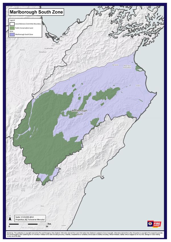
Zone B – Marlborough South
Geography The Marlborough South Zone encompasses all land in the Marlborough District,
including Department of Conservation land, but excluding Defence land at the RNZAF
Base Woodbourne, to the South of the Wairau River including the flat land from the
Eastern side of State Highway 1 from Tuamarina to Rarangi. State Highway 1 travels
in a North to South direction on the Eastern side of the Zone and State Highway 63
travels in a South West direction from Renwick.
The fire permit zones that make up the Marlborough South zone are Central
Marlborough Urban, Central Marlborough Rural, Lower Wairau, Marlborough West,
Wither Hills and Woodbourne.
Demographics At Fire and Emergency New Zealand, we have an in-depth knowledge of the
demographics for each of the communities we serve. These demographics help us to
understand the type of support each of our communities might need and how we
communicate with them.
We use this knowledge in all aspects of our work, including our delivery of the 4Rs of
emergency management and for fire control measures, such as declaring the
beginning and end of fire seasons, prohibiting and restricting the use fire, and issuing
fire permits.
Within the Marlborough South zone there is one medium and one small urban area
being Blenheim (population 2,530) and Renwick (population 2,530) respectively,
along with the following rural settlements:
• Wairau Valley – population 1,959
• Woodbourne – population 690
• Spring Creek – population 579
• Seddon – population 552
• Rarangi – population 690
• Grovetown – population 357
• Marlborough Ridge – population 230
• Ward – population 81
Climate/weather The Marlborough region has a temperate oceanic climate with warm summers, cool
winters, and rainfall distributed across the year.
The Marlborough South Zone enjoys one of New Zealand’s sunniest climates, with
warm, relatively dry summers and cool, crisp winters. Annual rain fall in this zone is
approximately 700 mm with some areas like the Awatere Valley, Lake Grassmere and
along the South Coast receiving less than 600 mm per year. It is not uncommon to
see annual rainfall figures below 300 mm per year in some locations.
The climate is generally very settled, largely due to the rain shadow effect of the
mountain ranges to the west which shelter the Marlborough South zone from the
heaviest of rains that hit the western part of the South Island.
Wind is predominantly from the North at an average of 9 months per year. Wind
from the West and the South average 1.5 months per year each.
Land cover/land Land cover in this zone is predominately grass fuels, consisting of high producing
use exotic grasslands and tall tussock grassland, and scrub fuels. There are also small
areas of vineyards, plantation forest and indigenous forest.
23 April 2021 26You can also read