Three Kings Plan Te Tātua o Riu-ki-uta - August 2014
←
→
Page content transcription
If your browser does not render page correctly, please read the page content below
Three Kings Plan
Te Tātua o Riu-ki-uta
August 2014
HE mihi
         Tēnei au te noho atu nei
         i te kāhiwi o Waikōwhai ki te uru.
         Ka mihi iho au ki raro ki te ākau o Manukau moana,
         he taunga kawau tiketike, te eke ki te tāhuna tōrea.
         Ka huri whakateraki aku kamo,
         ka kite atu au i te ara hou e kokoti mai rā i taku manawa
         me te Ahikāroa o Rakataura,
         kia tae au ki Te Tāpapakanga a Hape
         ka hoki mai anō taku hā,
         kei reira nei hoki kō Pukewīwī.
         Ka kite atu au i ngā wai kaukau o Rakataura
         ka hoki whakararo ano ōku whakaaro
         ki Te Tātua o Riu-ki-uta
         e tu ārai mai rā mōku i te whitinga mai o te rā.
         Kei tua ki te raki, ko te Puku o te Tipua nei o Tāmaki Makaurau,
         kei raro ko te Onehunga.
         Kātahi au ka hoki mā te Kāhiwi Pūpuke
         kia ū atu anō au ki a koe Waikōwhai.
         I kona ka tau aku mihi,
         ka eke, kua eke, hui e, taiki e!

         Here I sit
         on the western ridge overlooking Waikōwhai.
         I send my greetings below to the shores of the Manukau Harbour,
         landing place of visiting cormorant on the domain of the oystercatcher.
         My gaze turns northward,
         along the new path that cuts through the heart
         of the ancient fire-line of Rakataura,
         that takes me to Hape’s repose,
         to Pukewīwī
         where I can catch my breath.
         I gaze upon the bathing waters of Rakatarua - Ōwairaka
         my thoughts turn south
         to Te Tātua o Riu-ki-uta
         my boundary to the east.
         Beyond lies the Central Business District
         and to the south, Onehunga.
         From here I follow the ridgeline that is Hillsborough
         till I am back at Waikōwhai.
         And, there my greetings rest,
         we are bound, it is done!

2 | THREE KINGS PLAN
Foreword
The Three Kings Plan is an important platform to bring together aspirations of the community
for the future. It will provide a strategic focus for development occurring within the area over
the next 30 years. The plan provides residents, ratepayers, citizens and visitors of Three Kings a
vision which has been developed in partnership with the community, iwi, major landowners and
other stakeholders.

While the Puketāpapa Local Board has led the development of this plan, the board
acknowledges the significant input and assistance of local residents, community groups, iwi,
other partners and stakeholders in the process.

Within Three Kings, there are some existing challenges which present exciting opportunities for
the future. This plan aims to address these challenges and set some parameters and guidance
for future development.

Three Kings sits beneath the landmark Te Tātua o Riu-ki-uta or the Big King volcanic cone, as
one of the areas foremost defining landscape and cultural features. The area has the potential
to be an exciting and vibrant well-connected community for its residents. Protecting, enhancing
and celebrating its unique heritage and building a strong and attractive town centre has been
the focus for the consultative process that has led to the formation of this document.

The Puketāpapa Local Board hope that this plan will serve and guide the community, Auckland
Council and other partners to create a positive and flourishing community in Three Kings over
the next 30 years.

Puketāpapa Local Board

                                                                                         3 | THREE KINGS PLAN
4 | THREE KINGS PLAN

Contents
About this plan                             6

Auckland's planning framework               7

Consultation and engagement                 8

Principles to guide development             9

Puketāpapa and the Three Kings Plan area   10

Three Kings local urban analysis           12

Key move 1                                 15

Key move 2                                 19

Key move 3                                 23

Key move 4                                 27

Key move 5                                 31

Implementing the plan                      34

Projects                                   35

Acknowledgements                           36

                                            5 | THREE KINGS PLAN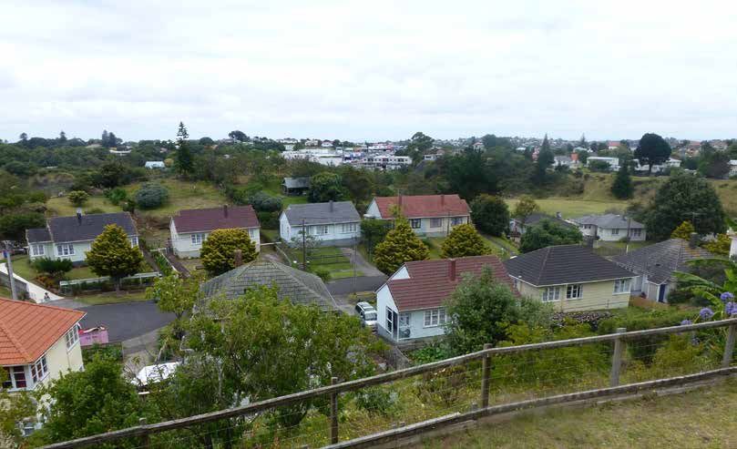
About this Plan
The purpose of the Three Kings Plan is to guide the development of Three Kings as a well-
connected place for people while protecting, enhancing and celebrating its unique heritage,
and to help create a vibrant town centre.
The Three Kings Plan is a 30-year strategic document that shows how the Auckland Plan will be
implemented at a local level. To move from a high level strategy to on the ground projects, the plan uses a
tiered approach.

                       Key Moves                                                 Outcomes
                                                              Outcomes are the local ‘on the ground’ results
                                                              we want to see happen over the next 30 years.
  This plan identifies five ‘key moves,’ which
  demonstrate, at a high level, how the area                  Three Kings is a diverse and multi-faceted area
  should respond to local issues and constraints.             so sustainable, positive change will need to
                                                              address several factors over the long term. For
  The key moves are thematic summaries of the                 this reason, the outcomes work as a package
  most important and the most desired changes                 and should be read collectively.
  that can be delivered during the next 30 years.
                                                              Outcomes will be achieved through specific
                                                              actions and projects.

                        Actions                                                   Projects

                                                              Projects are specific, targeted actions that
  Actions are general or specific undertakings                have an identifiable output. Projects that have
  that can be carried out to help achieve the                 funding allocated may have already undergone
  desired outcomes. Some actions may need to                  some degree of research and planning.
  continue over many years.                                   Projects that are unfunded or require further
                                                              consideration are ‘aspirational’.

Scope and limitations
The Three Kings Plan is a non-statutory document that provides strategic guidance about how the area
should develop to achieve long-term aspirational outcomes. The plan identifies specific actions and projects
that can be undertaken by the local board to facilitate the outcomes.

Rules or development controls applying to individual private sites are determined through consenting or
other statutory processes according to the Operative Isthmus District Plan and/or the Proposed Auckland
Unitary Plan and are not within the scope of this document. The content of the Three Kings Plan will
however, provide important information for consideration as part of any future plan change.

Issues raised during the consultation process for the plan that require further work include the final fill
contour in the quarry, the appropriate density of residential developments, infrastructure constraints
including stormwater and wastewater issues and in the quarry area fill rates and compaction factors.

6 | THREE KINGS PLAN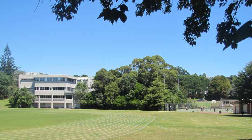
Auckland Planning Framework
The Auckland Plan                                    Local spatial plans
The Auckland Region is expected to grow by           Local spatial plans are non-statutory plans that
an additional one million people and 400,000         show how the Auckland Plan will be implemented
households by 2040. The Auckland Plan provides       at a local level. The Three Kings Plan is a local
strategic direction at a regional level about how    spatial plan that provides a long-term strategy for
growth will be managed without affecting the         development in the plan area.
things we love most about living in Auckland. The
Auckland Plan has identified six ‘transformational   As a 30-year strategic document, the Three Kings
shifts’ required to achieve the vision of Auckland   Plan requires a level of flexibility to accommodate
becoming ‘the world’s most liveable city’. These     changing circumstances. Rather than prescribe
are:                                                 detailed design solutions, the plan provides
1. Dramatically accelerate the prospects of          guidance around what environmental outcomes
   Auckland’s children and young people              could be achieved through future development.
2. Strongly commit to environmental action and
                                                     Proposed Auckland Unitary Plan
   green growth
3. Move to outstanding public transport within       Prepared under the Resource Management Act
   one network                                       1991 (RMA), the Proposed Auckland Unitary Plan
4. Radically improve the quality of urban living     (PAUP) will be the rulebook for Auckland that
                                                     determines the zones and rules that control what
5. Substantially raise living standards for all
                                                     can be built and where. The Three Kings Plan will
   Aucklander's and focus on those in need
                                                     be used to inform decisions made on submissions
6. Significantly lift Māori social and economic      to the PAUP regarding the Three Kings area.
   wellbeing
These six shifts are key drivers for the             Other processes
development of Auckland and form the basis for       Non-permitted development in the Three
the Three Kings Plan.                                Kings Plan area requires other RMA processes
                                                     before implementation can occur. For example,
                                                     redevelopment of the quarry site and town centre
                                                     may require changes to zoning and subsequent
                                                     resource consents. The Three Kings Plan will be
                                                     used to inform future statutory and non-statutory
                                                     processes when considering the future direction of
                                                     development and growth in the area.

                                                     Maunga Authority
                                                     Given that the Three Kings area contains
                                                     significant volcanic features, Tūpuna Maunga
                                                     o Tāmaki Makaurau Authority (the Maunga
                                                     Authority) is also relevant to this plan. The Maunga
                                                     Authority is comprised of equal representatives
                                                     of the Tāmaki Collective and Auckland Council, as
                                                     well as a non-voting Crown representative, and
                                                     is responsible for the management of Auckland’s
                                                     volcanic cones. The establishment of the Maunga
                                                     Authority ensures the protection of the cones,
                                                     whilst also maintaining public access.

                                                                                          7 | THREE KINGS PLAN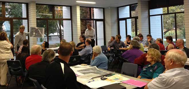
Consultation and Engagement
The quarry site has been a dominant local feature     • Engagement on the discussion document
in Three Kings for over 100 years but in recent         (May 2013), which involved community open
years there has been an increasing level of             days and the opportunity for the public and
community interest in the future of the site.           stakeholders to provide written feedback on the
                                                        different options being considered. Following
The former Auckland City Council first began            this a draft plan was developed.
looking at this issue in 2009, as part of the ten-    • A formal consultation process (June 2014),
year review of the Operative Isthmus District           through which the public could provide formal
Plan. Through this process, the council identified      written submissions on the draft plan.
the quarry as a potential site for future mixed-use
development.                                          Throughout each phase, the local board received
                                                      a significant amount of feedback from the public,
The Puketāpapa Local Board, established as part       as well as from key stakeholders. Community
of Auckland's local government reforms, also          feedback has played a significant role in informing
recognised the potential to revitalise the area and   the development of this plan and a separate
formally endorsed the development of the Three        feedback summary document has been prepared
Kings Plan in February 2013.                          to accompany this plan.

Following an initial scoping exercise, which          Key stakeholders
included defining a study area and establishing
                                                      Key stakeholders involved throughout the
guiding principles, council staff and the local
                                                      consultation and engagement process included:
board began gathering feedback from the local
community to help inform the development of the       •   Antipodean Properties Limited
plan.                                                 •   Auckland Council
                                                      •   Auckland Transport
Consultation with the local community and
stakeholders was undertaken in three phases:          •   Fletcher Developments Ltd
                                                      •   Housing New Zealand Ltd
• An initial engagement phase, which included
  various community workshops. Feedback               •   Mana Whenua
  gathered through the workshops was used to          •   Ministry of Education
  create a discussion document with five broad        •   South Epsom Planning Group
  options for the development of the area.            •   Three Kings United
                                                      •   Watercare Services Ltd

  Community workshop held in early 2013

8 | THREE KINGS PLAN
Principles To Guide Development
In order to guide the development of this plan, and to provide direction for future processes, the Puketāpapa
Local Board developed a set of principles, in consultation with the community. These principles should be
read in conjunction with the purpose, key moves and outcomes of this plan. The principles are:
• Increase the total amount of quality public open        • Focus town centre development on the
  space, including playing fields and informal              northern side of Mt Albert Road with improved
  recreation spaces                                         connections to the southern side
• Improve and manage appropriate access to Te             • Provide good quality, safe pedestrian and cycle
  Tātua o Riu-ki-uta/Big King and rehabilitate              linkages across and between the residential,
  the landscape values of the maunga as a                   open space and town centre
  defining cultural and environmental taonga and          • Provide a well-designed transport interchange
  landmark                                                  that enhances public transport use
• Ensure that topography and contours of                  • Provide affordable and social housing
  previously quarried land integrates connections
                                                          • Consideration for existing and revealed heritage
  between residential areas, open spaces, Mt Eden
                                                            sites to be integrated into future development
  Road and the town centre
                                                          • Provide a range of high quality housing types
• Retain key views to Te Tātua o Riu-ki-uta/Big
                                                            and densities that support a more intensive and
  King from Mt Albert and Mt Eden Road
                                                            active town centre in any future development
• Create an attractive and appropriately scaled
                                                          • Integrate Te Aranga Māori design principles in
  town centre with open and inviting public
                                                            future development.
  spaces

The Key Moves:
This plan identifies five ‘key moves’ which demonstrate at a high level how the area should respond to local
issues and constraints. The key moves are thematic summaries of the most important and the most desired
changes that can be delivered during the next 30 years. The key moves are:

1. Recognise and restore the mana of Te Tātua o Riu-ki-uta/Big King and
   enhance the public open space network
2. Revitalise the Three Kings town centre
3. Encourage high quality residential development
4. Improve connections between people and places
5. Develop a sense of local character and identity around the presence of Te
   Tātua o Riu-ki-uta/Big King

                                                                                              9 | THREE KINGS PLAN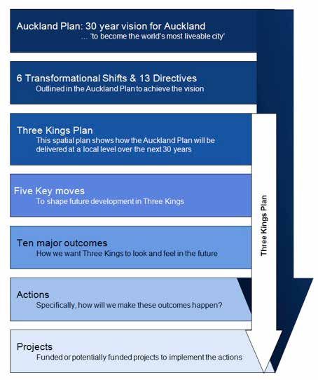
Three Kings
                                                         Plan Area

                                         Puketāpapa

                                                                                                            1:25000 @ A3 N
                                                                                                  0   250 500      1km

Puketāpapa AND the THREE KINGS plan area
Place and people                                   Mana Whenua and iwi
The Puketāpapa Local Board borders the Manukau     The Māori name for Three Kings is Te Tātua-o-Riu-
Harbour and includes the suburbs of Three Kings,   ki-uta, meaning the belt of Riu-ki-uta. Riu-ki-uta
Hillsborough, Waikowhai, Lynfield and Wesley.      was a Tainui ancestor who settled in the area and
There are approximately 53,000 people and          his descendants Ngāti Riu-ki-uta, were known as
20,000 dwellings in the Puketāpapa Local Board     the local hapū at that time.
area, and the population is expected to grow to
approximately 65,000 by 2041.                      Three Kings was once intensely settled and
                                                   gardened by Māori and locally constructed pa were
Three Kings is located at the intersection of      noted for their unusual use of stone masonry to
Mt Eden and Mt Albert Roads at the southern        strengthen fortifications. This led to a saying ‘ka
end of the Auckland Isthmus. The area takes        tū he pari tokatoka, ka horo he pari oneone' - a
its name from the volcanic cones, which were       rampart built from stone stands; those built from
formed in an eruption around 30,000 years ago.     earth will crumble’. Three Kings is also noted for its
The plan boundary loosely follows the remnants     numerous recorded burial caves.
of the volcanic 'tuff ring', covering an area of
approximately 112ha. The plan area comprises the   Approximately 3000 people who identify as Māori
following:                                         still live in the Puketāpapa Local Board area. The
                                                   development of the Three Kings Plan has provided
•   Residential - 52 ha (46%)
                                                   a unique opportunity for the local board to build
•   Open space (incl. streets)- 32 ha (29%)        relationships with Mana Whenua. The board
•   Quarry - 15 ha (13%)                           is committed to furthering those relationships
•   Commercial - 7ha (6%)                          through the implementation of this plan.
•   Institutional / Community - 5ha (5%)
Approximately 3000 people live within the plan
area and there are around 900 dwellings.

10 | THREE KINGS PLAN
Historic development
Europeans first settled and began farming in
the Puketāpapa area in the mid 1800s. The area
remained largely rural until after World War 1.
The end of the war resulted in increased demand
for housing. This, combined with widely available
government loans encouraged speculative
development on the rural fringes of Auckland,
including parts of Puketāpapa.
The extension of the tram lines to Mt Albert
Road in 1930 was a catalyst for further housing
development in the area. The 1940s and 1950s
then saw a significant expansion of state housing,
including the Wesley Block development to Three Kings 1940 0 50
1:5000 @ A3 N
100 200
the west of Te Tātua o Riu-ki-uta/Big King.
The architectural style and building orientation
patterns characteristic of this development are still
largely intact today.
The increasing population in the area led to greater
demand for local services and shops. Three Kings
Plaza was opened in 1968 and the Fickling Centre
and Mt Roskill Library were developed around
1975. Over time, the subdivision of farmland
allowed new secondary industries, such as sheet
metal, joinery and textiles, to establish along Carr
and Stoddard Roads. Today, the area still exhibits a
wide variety of development scales and land uses.
Three Kings topography
The topography of Three Kings is largely
characterised by the formation and subsequent Three Kings 1960 1:5000 @ A3 N
0 50 100 200
modification of the volcanic landscape of Te Tātua
o Riu-ki-uta/Big King. The maunga was formed
around 28,500 years ago and sits within the centre
of a large explosion crater. 80
115
80
55
80
Quarrying first began in the area in the late 1800s. 90
10
0
125
Originally there were five volcanic cones however, 85
75
65
12
0
70
95
70
four of these have been quarried away to provide
75
11
0
100
105 110
80
120
drainage material for central Auckland. Today, Te
75
125
75
10
5
85
115
50
Tātua o Riu-ki-uta is the last remaining cone, and
95
95
50
55
90
65 70
80
the primary landmark and cultural feature for the 90
70
90
75
area.
35
80
45 55
80
40
55
60
50
45
95
85
40
90
60 50
85
60
85
The highly modified environment of the adjacent
75
80
80
85
75
quarry site is in stark contrast to the natural 80
75
70
70
volcanic landscape and is the second defining
feature within the plan area. 65
90
60
95
95
Three Kings Topography 0 50
1:5000 @ A3 N
100 200
11 | THREE KINGS PLANThree Kings Local Urban Analysis
The Three Kings Plan provides strategic direction for the organisation of the key structural elements
of the local urban environment. To make informed recommendations, it is important to first
understand how the existing environment functions. This section provides the evidential basis
for discussing local issues by examining the fundamental physical elements of the local urban
environment - plot, block, buildings and land use.
Plot pattern Block pattern
Plots are units of land ownership. Plot boundaries The block pattern shows the layout of the urban
change as land is (re)subdivided, amalgamated, block structure and the streets between the blocks.
and sold so patterns over time tend to be The block pattern determines the options people
associated with variations in land value. have when choosing a route to a destination. This
characteristic is referred to as permeability. Areas
In Three Kings, there is an area of large, irregularly that have many small blocks and a large number
shaped plots surrounding the central quarry site. of streets are said to have a fine grain. Areas
This suggests the quarry was established early with a few large blocks and a small number of
in the development of Three Kings and that it connections are said to have a coarse grain. Once
has been subdivided off incrementally over time, established, the street pattern tends to be resilient
allowing new activities to establish around the to change and provides the framework around
periphery of the site. which other features of the environment develop.
Surrounding the irregular plots are different Three Kings is currently characterised by a large
sized areas of smaller regularly shaped sites. central block with many no exit streets. This is
The regularity is evidence that these sites were primarily due to the steep volcanic topography and
part of large scale planned subdivisions typically large industrial and commercial sites being barriers
associated with economic booms. The fact that to establishing connections. Surrounding this, the
they completely surround the larger irregular plots older streets to the north and east of the maunga,
suggests they were developed as part of a later follow a traditional grid style street pattern.
period of residential expansion after the quarry
was already established.
1:5000 @ A3 N 1:5000 @ A3 N
Three Kings Plot Pattern 0 50 100 200
Three Kings Block Pattern 0 50 100 200
12 | THREE KINGS PLANBuilding pattern Land Use pattern
The building pattern shows how buildings are Land use patterns show the variety and spatial
arranged in relation to each other. The Three Kings arrangement of local activities. Land use is closely
building pattern clearly shows the majority of related to property values and can change through
buildings are independent structures surrounded time. New land uses often lead the process of
by sometimes significant areas of empty space. change by providing a catalyst for subdivision or
The reason for this pattern is that many of the plot amalgamation.
commercial buildings are later developments
designed according to their internal functional In Three Kings, the land use pattern shows a
requirements and to facilitate travel by car. variety of different activities in the central area
surrounded by extensive areas of homogeneous
The main type of housing in Three Kings is single residential development.
detached dwellings. Areas to the north and east
of the quarry are older residential areas developed The variation in activities around the quarry
during the inter-war period of the early 1900s. is due to different market responses to the
The predominant architectural style is Californian incremental subdivision. As a result, development
bungalows, however there has been significant is fragmented with small areas of land use located
infill development in this area. around the quarry. Each of these clusters have
developed a different character, for example, the
Most of the dwellings to the west of the northern commercial area has a different character
town centre are part of a large social housing and function to the Three Kings town centre.
development constructed in the post-war period.
Compared to the older areas, there has been
very little infill development in this area and
the architectural style and pattern of building
orientation is largely intact.
1:5000 @ A3 N 1:5000 @ A3 N
Three Kings Building Coverage 0 50 100 200 Three Kings Land Use 0 50 100 200
Community or institutional Residential
Retail, business or trade Quarry
Leisure Industrial, warehouse or manufacturing
13 | THREE KINGS PLANKey Move 1:
Recognise and restore the mana of Te Tātua o Riu-ki-uta/Big
King and enhance the public open space network
Public space relates to all parts of the built and natural environment where the public have free access. The
local urban analysis section showed that, while there is a large overall quantity of open space within Three
Kings, some areas are underused or poorly quality. This is primarily due to some of the open space areas
being poorly connected and integrated with the surrounding environment.
Community feedback indicated that Te Tātua o Riu-ki-uta and Three Kings Reserve are important local
spaces, valued for both their aesthetic qualities and the opportunities they provide for interaction
and activity. Creating a strong open space connection between the town centre and the maunga, and
rehabilitating the landscape character of the maunga, were recurring themes during the plan development
process.
A network of spaces
Public open space is more than just green areas.
It includes streets, plazas and publicly accessible
buildings that collectively define local patterns of
movement and social interaction.
In Three Kings, two open space areas to the south
and south-west of the quarry site (referred to as
the central and western open spaces respectively)
are relatively recent subdivisions of previously
quarried land. These areas were never planned
or designed with a particular use in mind and are
poorly integrated and connected, both to each
other, and their surrounding land uses.
1:5000 @ A3 N
Public Open Space Network 0 50 100 200
Open space
An opportunity to reshape the network Providing a balance of recreational
opportunities
The future redevelopment of the quarry site
provides a unique opportunity to proactively Public space is about more than just physical
shape the open space network to best support location, it also includes the activity that occurs
community needs. within that setting. Different kinds of spaces
provide opportunities for both formal and informal
Based on community feedback, the spatial strategy use. It is important to ensure that the public open
involves creating a ‘green spine’ of open space that space network provides opportunities for as many
connects the maunga to the town centre. From users as possible.
there, hard spaces like plazas and a pedestrian-
oriented mainstreet could be used to continue the Council data on provision of open space indicates
connection to other areas. that there is currently a shortfall of sports fields
in the local area. New sports fields with a better
Once completed, the series of spaces would configuration could be provided within the plan
provide a complete open space link from Mt Albert area. There are many technical factors that are
Road through to the Duke Street neighbourhood likely to affect where any sports fields would be
shops. located and these issues will need to be addressed
through future processes.
14 | THREE KINGS PLANKEY MOVE 1: OPEN SPACE CONTEXT & ISSUES
Te Tātua o Riu-ki-uta/Big King:
● the natural landscape has been heavily
modified from quarrying
● residential development is encroaching on
the western slopes
Western open space: ● no/poor connections to Te Tātua o
● previously quarried land Riu-ki-uta/Big King, particularly from the
● poorly connected and integrated east
REET
with surrounding environment DUK
E ST ● low local bio-diversity
● shortage of sports fields in local
area
● single field configuration limits
flexibility of use
● poor access to toilets and changing
facilities
● poor surveillance
MCC
Steep topography is a barrier
ULLO
to connection and integration
UGH
Central open space: between spaces
AVEN
AD
EDEN RO
● previously quarried land
E U
● poorly connected and
MOUNT
integrated with surrounding
area
● potentially contaminated
● the shape of the plot limits
potential usability
BERT ROAD
MOUNT AL
Three Kings Reserve and other
facilities are well used but poorly
integrated with the town centre
and other open spaces
Town centre:
● weak physical and psychological
relationship to Te Tātua o
Riu-ki-uta/Big King
● the town centre has no true ‘civic
heart’ or quality public spaces
1:10,000
Open space Poor/weak integration
0 50 100 200m
Local cultural landmark Poor/weak physical
connection
Steep grade change 15 | THREE KINGS PLANKey Move 1:
Recognise and restore the mana of Te Tātua o Riu-ki-uta/Big
King and enhance the public open space network
Outcomes and Actions
OUTCOME 1: Te Tātua o Riu-ki-uta/
Big King is recognised as a site of
OUTCOME 2: A high quality open space
immense cultural and historical
network is created that integrates
value by rehabilitating the land-
surrounding land use and supports
scape, improving access, providing
cycle and walking links
for appropriate uses and protecting
views
Actions: Actions:
1.1 Retain key views to Te Tātua o Riu-ki-uta/ 2.1 Investigate filling and/or exchanging
Big King from the town centre and main portions of council owned or managed
arterial routes land to improve the quality of the open
1.2 Advocate for the rehabilitation of the space network and improve integration
landscape character of Te Tātua o Riu- with surrounding land uses
ki-uta/Big King through adequate and 2.2 Advocate for public open space connecting
appropriate contours of all developed land Te Tātua o Riu-ki-uta/Big King with the
1.3 Provide appropriate and legible pedestrian town centre
and cycle connections to Te Tātua o 2.3 Investigate options to increase public
Riu-ki-uta/Big King and other reserve land, sports field provision in balance with
particularly from the town centre quality passive open space
The formally quarried central and western open space areas viewed from Te Tātua o Riu-ki-uta/Big King
16 | THREE KINGS PLANKey Move 1:
Recognise and restore the mana of Te Tātua o Riu-ki-uta/Big
King and enhance the public open space network
Spatial strategy map
Improved connections and Open space network links
integration enhance Te Duke Street shops to Mt
Tātua o Riu-ki-uta/Big Albert Road
King’s status as a key land-
mark & cultural feature E ST
REET
DUK
Rehabilitated south eastern corner
of maunga enhances landscape
values and provides improved
pedestrian connections
A strong physical and psychological open
space connection is established between
the new civc heart/node and Te Tātua o
Riu-ki-uta/Big King:
● final contours of quarried land should
MCC
facilitate accessible transition to north
ULLO
west
UGH
● use of the western open space is
AVEN
AD
reviewed and an appropriate use
EDEN RO
U
established
E
MOUNT
Sports fields provide
balanced opportunities
A new civic heart/node: for active recreation
● acts as a focal point for the
community
● located at northern end of town
centre where views from key MO
UNT
public spaces will improve ALB
ERT
ROA
D
legibility & reinforce local
identity
● links the north west open space
connection with spaces in the Northern pedestrian-oriented
town centre and Three Kings mainstreet links Mt Albert to green
Reserve open spaces
1:10,000
0 50 100 200m
Open space connection
Open space Active open space (to be investigated)
Rehabilitated / buffer area Plaza area Civic heart / node
(to be investigated) (to be investigated)
Existing open space Local cultural Pedestrian oriented
Key views landmark mainstreet
(future use to be investigated)
17 | THREE KINGS PLANKey Move 2:
Revitalise the three kings town centre
The local urban analysis showed that Three Kings has a very weak commercial mainstreet. The large format
buildings in the Three Kings Plaza provide for essential daily needs but their relationship to adjoining spaces
undermines the quality of the local environment. Under the Auckland Plan, Three Kings is identified as an
‘emergent town centre’ requiring significant change through redevelopment to support its transition to a
more intensive, mixed use centre.
Throughout the development of the Three Kings Plan, feedback has indicated a strong community desire to
create a town centre with a ‘vibrant, mixed-use village atmosphere’. This section discusses what that means
and what practical measures could be undertaken to help achieve that goal.
The relationship between buildings and space
The way in which buildings are organised plays
an important role in shaping the character of the
environment.
In traditional 'village-like' town centres, buildings
are typically located close to one another and
adjacent or close to the street. This development
pattern helps to define and activate public areas.
Traditional (left) and modern (right) centre development
Where possible, buildings should adjoin street
edges in a way that creates a positive sense of
enclosure.
Activity and the public private interface
The relationship between public and private
spaces is an important source of interest in town
centres. This interface usually happens at building
entrances.
Where possible, buildings entrances should face
streets and plazas to encourage activity around
the edges. Parking, rubbish and other clutter can
be hidden at the rear of the building without
compromising the public environment. When this
pattern is applied consistently, this creates a type
of development called a perimeter block. Different examples of perimeter block development
Encouraging a mixture of uses Enclosure and building height
A more vibrant public realm comes from an To provide a positive feeling of enclosure while
intensification of activity. Large-scale magnet maintaining a 'human scale', building heights
stores like the supermarket play a vital role in should relate to the width of adjacent streets. An
attracting people to an area. However, a mixed approximate height to width ratio of 2:1 can be
use environment will require different kinds of used as a rule of thumb. Set backs at upper levels
adaptable buildings to accommodate a variety of can be used to provide additional height without
different tenants and uses over their life time. compromising the 'village feel'.
18 | THREE KINGS PLANKEY MOVE 2: TOWN CENTRE CONTEXT & ISSUES
Northern commercial areas:
● independent character and function
● weak connection to town centre
● hard interface between large
REET format commercial/warehouse
E ST
DUK development & surrounding areas
AD
EDEN RO
MCC
MOUNT
ULLO
UGH
AVEN
Three Kings Plaza:
E U
● internally focused building Three Kings Reserve and other
● poor relationship to surrounding space community facilites are well used
● no civic heart but they are poorly integrated with
● single anchor tenant the town centre and school
● poorly connected to northern areas
● significant areas of carparking and
confusing access points detract from
public amenity M OUN
T AL
BER
T RO
AD
● weak mainstreet development along
Mt Albert Road
● the northern and southern sides of
Mt Albert Road are poorly connected
Retail focus Community building Poor/weak integration 1:10,000
0 50 100 200m
Poor/weak physical
Weak mainstreet Large format connection
Open space Local retail focus Node 19 | THREE KINGS PLANKey Move 2:
Revitalise the three kings town centre
Outcomes and Actions
OUTCOME 3: Three Kings is a people-
oriented town centre with a vibrant OUTCOME 4: Residents have access to
mainstreet, quality public spaces excellent community facilities and
and legible, civic and open space services that meet their needs
quarters
Actions: Actions:
3.1 Advocate for the development of a town 4.1 Develop a community/civic quarter
centre masterplan to enable coherent around existing Council facilities, including
and viable use of the town centre which refurbishing the Roskill Borough Building
includes: for civic and community use
-- a new pedestrian-oriented main street 4.2 Investigate future use of the existing
northwards from Mt Albert Road depot site on Grahame Breed Drive for
towards the quarry with interactive community (including Mana Whenua)
edges adjoining other open spaces uses
-- attractive commercial and/or retail 4.3 Investigate the need for appropriate
developments that are well integrated
services and community facilities that
with the overall mixed use environment
could be accommodated in the civic
-- an attractive public plaza that acts as a
quarter
community node
-- rationalised car parking and better use
4.4 Support a community needs assessment
of public parking areas for Three Kings
-- improved connections to the southern
side of Mt Albert Road and from the
intersection of Mt Eden/Mt Albert Roads
to the town centre and community
facilities
3.2 Retain the commercial area to the
north of the quarry (to provide local
employment) that is of a size and scale
compatible with surrounding development
3.3 Advocate for high quality mixed use
development that enables people to live,
work and play in the town centre
3.4 Support an active and inviting street
frontage along both sides of Mt Albert
Road with retail activities focused on the
northern side
20 | THREE KINGS PLANKey Move 2:
Revitalise the Three kings town centre
Spatial strategy map
Duke Street shops role as
The relationship between commercial neighbourhood centre and
areas and Te Tātua o Riu-ki-uta/Big King northern gateway to Three
is strengthened to encourage a shared Kings is strengthened
REET
E ST
sense of local identiy DUK
Improved pedestrian and cycle
amenity along arterial corridors
Residential development shall be
designed to support the Three Kings Northern end of town centre becomes
town centre as the community and focal point that provides:
commercial hub ● unobstructed views to maunga and
north west
● direct and legible connections to
MCC
surrounding areas including the maunga,
ULLO
quarry area and commercial mainstreet
UGH
● appropriately located active edges and
AVEN
AD
public spaces
EDEN RO
U
Town centre provides:
E
● a northern extension to create a
MOUNT
building layout that clearly defines and
activates public spaces
● a permeable and legible block
The layout of the town centre and its
structure buildings shall reflect best practice
● north-south pedestrian-oriented
urban design principles including the
commercial mainstreet creation of a walkable centre with a
● an appropriate edge and activation for
clear hierachy of spaces and networks
MO
council side of mainstreet UNT
ALB
ERT
● a mixture of mutually supportive ROA
D
activities including residential
● an improved connection to southern
side of Mt Albert Road
1:10,000
0 50 100 200m
Civic plaza spaces Civic heart / node
Retail focus (to be investigated) Key views
Pedestrian / cycle connection
Community focus Open space Local cultural landmark
(to be investigated)
Mixed focus Large format focus Vehicle access Improved public transport &
(to be investigated) corridor design
Pedestrian oriented Improved connection
Local retail focus mainstreet Existing vehicle access
21 | THREE KINGS PLANKey Move 3:
Encourage high quality residential development
The local urban analysis section showed that residential development in Three Kings is characterised by
single detached dwellings and a noticeable difference in housing intensity between the western and eastern
residential areas. The quarry site provides a significant opportunity to provide additional residential capacity
within walkable distance of the town centre.
Feedback received through community engagement indicated a desire for Three Kings to be a diverse
and inclusive community but that new residential development should be well integrated, accessible and
responsive to the existing environment.
The strategic context Although areas to the east and south of the town
centre have already undergone significant infill
Three Kings is a strategically attractive area to housing, the quarry and the residential area to the
accommodate growth for a number of reasons: west of the town centre provide opportunities for
• It is located at the intersection of two major high quality, integrated housing provision.
road corridors so land use can be more easily
co-ordinated with transport infrastructure. Infrastructure
• The quarry site is a 15ha brownfield opportunity A key issue for growth is that the combined
located close to the Three Kings town centre. wastewater and stormwater system is currently
• Redevelopment of the quarry could provide a at capacity meaning any future developments will
catalyst for redevelopment of Three Kings town need to consider potential impacts on the system
centre. and how these can be mitigated. Solutions to the
• The relatively small number of major issue will need to involve a combination of smaller
landowners makes it easier to undertake a co- scale management solutions to reduce strain on
ordinated development response. the system, as well as splitting the combined
system over the medium to long term.
• Rising land values are providing a necessary
market incentive.
Topography
Encouraging a diverse and inclusive community
The existing topography of the quarry provides
A diverse and inclusive community will require a challenges for integration and connection.
range of housing types, sizes and tenures. This will However, it also provides an opportunity to
help to ensure local residents can make a housing develop more intensive residential typology close
choice appropriate for their circumstance and to the town centre, while minimising effects on
needs. It also means that long term residents have the existing character.
the flexibility to change dwelling-type without
necessarily having to leave the community. In 2011, Winstone Aggregates was granted
resource consent to begin filling the quarry site.
Development that is well integrated and The final contour of previously quarried land will
responsive to the environment be a key factor in determining how the outcomes
identified in this plan are to be achieved. The
To encourage the character of Three Kings to current situation is that the final contour will be as
evolve in a positive manner, new development set out in the 2011 resource consent.
should be provided in a coherent and co-ordinated
manner. Since that consent was granted, Fletcher
Developments have released a revised vision
Where possible, higher intensity development indicating how they intend to develop the quarry
should be provided closer to established centres for residential use. Community feedback has
to support a walkable environment and the viable indicated a strong desire for the quarry to be filled
provision of local infrastructure. prior to being redeveloped.
22 | THREE KINGS PLANKEY MOVE 3: RESIDENTIAL CONTEXT & ISSUES
Intensive residential development
Te Tātua o Riu-ki-uta/Big King is not close to town centre or re-
● new development will need to be sponsive to local context
sensitive to the cultural
significance of the volcanic
landscape
REET
E ST
DUK
Quarry site:
● significant gap in built form
disrupts integration between
adjacent residential areas
● strong community desire for
the quarry to be filled before
redevelopment
Western residential area: ● in 2011 the Environment
● predominantly single detached dwellings
Court granted Winstone
● 1950s social housing architecture and
Aggregates consent to fill the
building orientation still intact quarry. This consent remains
● high levels of public sector ownership
in place until any alternative
● low levels of infill housing
proposal gains approval
● development is encroaching on the
sensitive volcanic landscape
● poor pedestrian connections to the town
AD
EDEN RO
centre and school
MC
CU
● combined stormwater and wastewater
LLO
MOUNT
Residential areas to the east
UG
infrastructure is at capacity
HA
and south of town centre have
VE
NU
already undergone significant
E
infill development
Central Open Space:
● could segregate town centre from ROAD
MOUNT ALBERT
redeveloped quarry Three Kings School
● residents in the quarry would have to roll at capacity
walk an additional block to access local
services
● significant break in built form
potentially means streets and buildings
in the town centre and the quarry are
Significant grade changes create a
unlikely to relate to each other
barrier to north-south and east-east
movement and make establishing
new connections difficult
Public open space Poor/weak physical 1:10,000
connection 0 50 100 200m
Quarry Intensive residential
School Steep grade change Poor/weak integration 23 | THREE KINGS PLANKey Move 3:
Encourage high quality residential development
Outcomes and Actions
OUTCOME 5: New residential
development is well integrated
and connected to the surrounding OUTCOME 6: Development is serviced
environment, responds to the by adequate provision of sustainable
appropriately rehabilitated Local network and social infrastructure
landscape, built character and
heritage features
Actions: Actions:
5.1 Advocate for a variety of appropriate 6.1 Support investigation into how existing
residential typologies in quarry quarry infrastructure could be used
redevelopment to address stormwater/wastewater
5.2 Support appropriate levels of social and infrastructure network constraints in
affordable housing to ensure a mixed and surrounding areas
inclusive community 6.2 Advocate for new development to
5.3 Advocate for residential development incorporate water sensitive urban design
south of Mt Albert Road to take into principles to manage stormwater on site
account ridge line and sunlight issues and where practical
for higher intensity development to be 6.3 Work with appropriate agencies to enable
broken up with open space long-term improvements in education,
5.4 New developments incorporate health and social services in the area
appropriate levels of landscaping that 6.4 The design, energy and systems of
utilise native species to enhance building should be designed to reduce
biodiversity their environmental impact. They
shall incorporate water efficiency and
conservation, and utilise materials that
have reduced impacts on the environment
over their entire life cycle
OUTCOME 7: Fill levels and resulting
Topography and contours in the
quarried areas avoid physical
segregation with adjacent land and
enable strong and highly accessible
connections
7.1 Advocate for final fill contour that provides
improved connections and integration with
surrounding areas
24 | THREE KINGS PLANKey Move 3:
Encourage high quality residential development
Spatial strategy map
Duke Street shops role as neighbourhood
centre and northern gateway to Three
Kings is strengthened and additional Quarry is redeveloped for residential use:
residential capacity is provided close to REET ● finished contour of land improves
E ST
DUK connection and integration with
local services and public transport
surrounding areas
● new development is sensitive to volcanic
landscape
● new built form fronting Mt Eden Road
improves integration between surrounding
Western open space: areas and allows views to maunga
● area is reviewed and an appropriate use ● a variety of land use zones, including open
established space, are provided to implement the plan
● public access is maintained and key moves
enhanced ● a variety of residential typologies are
● development is sensitive to volcanic provided
landscape and existing housing character ● greater residential intensity close to the
● new connections are made that link the town centre and public transport
area to the surrounding environment
MCC
ULLO
UGH
AVEN
AD
EDEN RO
E U
Residential development incorporates
MOUNT
the principles of sustainable, inclusive
and resilient communities
Eastern portion of central open space:
● residential use is investigated
● a more intensive residential typology is
provided close to the town centre
● new streets and buildings relate to town
Greatest residential capacity is MO centre
UNT
provided within walkable distance ALB
ERT ● existing mature trees screen development
ROA
to town centre to support vibrant D
● shading of the town centre and other
atmosphere and provision of public spaces is avoided
infrastructure ● outlook is provided over Three Kings
Reserve and new open space in the quarry
1:10,000
0 50 100 200m
Residential - low /medium change Residential Open space connection
(to be investigated) (to be investigated)
Residential - medium change Civic heart / node
Town centre
400m / 800m
Residential - higher change Mixed use from town centre
25 | THREE KINGS PLANKey Move 4:
improve connections between people and places
Local urban analysis showed that Three Kings has a large block structure with few street connections,
particularly between the east and west. Three Kings is located at the intersection of Mt Albert and Mt Eden
Roads, which are identified as arterial roads under Auckland Transport’s Integrated Transport Plan (ITP).
While a hierarchical street network is useful for facilitating vehicle circulation, large roads can be barriers to
pedestrian movement.
Public feedback during the plan development process consistently expressed a desire for a well connected
and accessible environment that supports walking and cycling.
Movement in Three Kings Permeability and block pattern
Understanding movement patterns is fundamental Large blocks reduce permeability because they
to understanding how a place functions. In Three restrict the choices a person has when determining
Kings the large block structure and hierarchical a route to their destination. Redevelopment of
road network create barriers to pedestrian the quarry site provides a rare opportunity to
movement and reinforce car dependency. ‘break up' the large central block and improve
permeability within the local area. Block lengths
Cars provide a convenient mode of transport but between 80-100m help to create a more
vehicle circulation does not provide the same permeable walking environment.
opportunity for social and economic exchange
as pedestrian movement. Facilitating easy Designing new connections
pedestrian travel is a vital part of encouraging a
vibrant urban centre. Areas like Three Kings that Visual permeability is an important aspect
have been designed around cars often have gaps of improving physical connection as it allows
in the pedestrian network that contribute to a someone to understand how to get to their next
fragmented environment. destination. Visual permeability largely depends
on where blocks are located in relation to access
points. In areas with more than one block, it is
important that paths are designed in relation to
access points from the neighbouring environment
so people can easily move through the site.
Key
Quarry
Open space
Town centre
Access point
New connection
1:5000 @ A3 N
0 50 100 200
1:5000 @ A3 N
Existing Movement Network 0 50 100 200
Example of how new connections could create smaller
Regional Arterial Roads Collector Roads Walkways
District Arterial Roads Local Roads blocks that integrate with the existing network
26 | THREE KINGS PLANKEY MOVE 4: MOVEMENT CONTEXT & ISSUES
Volcanic Landscape: Mt Eden Road prone to traffic
● many no-exit roads congestion
● topography makes establishing
direct connections difficult
● cycling can damage the
sensitive volcanic landscape REET
E ST
DUK
Quarry site is a very large
block with no connections,
particularly between the
east and west but also
north and south
AD
Three Kings town centre:
EDEN RO
● pedestrian connections are
segregated and hidden
MOUNT
MC
● poor pedestrian amenity
CU
LLO
around town centre Arterial street network has poor
UG
HA
● car oriented development pedestrian and cycle amenity
VE
NU
reduces incentive to walk or and is a barrier to movement
E
use public transport
MO
UNT
ALB
ERT
ROA
D
Poor pedestrian connection
between town centre and Carr
Road commercial area and Mt
Roskill Grammar
Steep grade Poor pedestrian/cycle 1:10,000
change amenity 0 50 100 200m
Open space Poor/weak physical
connection
27 | THREE KINGS PLANKey Move 4:
improve connections between people and places
Outcomes and Actions
OUTCOME 8: Development supports
OUTCOME 9: The street and
alternative modes of transport
movement network supports a
and reduces reliance on the private
permeable, legible and accessible
vehicle or encourages the use of
environment for all
public transport
Actions: Actions:
8.1 Advocate for an appropriate intensity of 9.1 Advocate for direct, legible, safe and
development that encourages the use of universally accessible pedestrian and
reliable, high frequency public transport cycle links (including suitable gradients)
8.2 Advocate for improved connections between residential, open space and town
between the town centre with surrounding centre areas:
land uses and public transport routes, -- the western residential area to Mt Eden
including possible future rail Road;
-- from the town centre to and around
8.3 Work with Auckland Transport to ensure
Te Tātua o Riu-ki-uta/Big King where
the development of a bus interchange appropriate; and
for Mt Albert and Mt Eden Roads that
-- from Fyvie, Smallfield and Barrister Ave
meets the needs of the community and to open space areas
helps increased use of the public transport
network 9.2 Integrate open space with connections
to expand the Puketāpapa Greenways
Network to assist in creating a network of
city wide pedestrian and cycle links
9.3 Support a study to understand the impact
of development on local transport needs
9.4 Advocate for good local outcomes through
the completion of a Corridor Management
Plan for Mt Eden Road
28 | THREE KINGS PLANKey Move 4:
improve connections between people and places
Spatial strategy map
REET
E ST Duke Street shops role as
DUK
neighbourhood centre and
northern gateway to Three
Kings is strengthened
A strong physical and visual
connection between the civic
heart and Te Tātua o New streets and connections are
Riu-ki-uta/Big King is made that break up the large block,
established integrate with adjacent networks
MCC
and facilitate easy east-west and
ULLO
north-south connections
UGH
AVEN
AD
EDEN RO
E U
MOUNT
Pedestrian and cycle amenity along
arterial corridors is improved
Town centre:
● has an easily understood, fine grain
MO
block structure that connects to UNT
ALB
ERT
ROA
surrounding streets D
● re-oriented commecial mainstreet
creates link between Mt Albert Rd and
Te Tātua o Riu-ki-uta/Big King and
Duke Street shops
1:10,000
0 50 100 200m
Open space connection Pedestrian / cycle connection
(to be investigated) (to be investigated)
Pedestrian oriented
mainstreet Existing vehicle access Bus interchange
Improved public transport Vehicle access
(to be investigated) Improved connection
& corridor design
29 | THREE KINGS PLANKey Move 5:
Develop a sense of local character and identity around the
presence of te Tātua o Riu-ki-uta/big king
Character and identity are shaped by people's feelings and perceptions of their environment. However,
perception is about more than how a place looks. The urban environment is experienced in many ways at
once, creating patterns in our mind that make a particular place feel distinct. Modern large format retail
developments however, often have few defining features that can make them feel 'placeless.'
Community feedback expressed a sentiment that the town centre lacked character and local urban analysis
showed that the majority of buildings in Three Kings are independent developments that have only weak
relationships to their surroundings. Creating a more clearly structured urban environment will encourage a
stronger sense of local identity by creating spaces that are easily understood, functional and inviting.
Legibility
A legible environment is one which allows people
to make clear mental images about how a place
is organised and arranged. Certain features are
more important than others in shaping how people
perceive a place. These features can loosely be
categorised into:
• Paths – streets, pedestrian routes and
movement channels
• Nodes – focal points and junctions
• Landmarks – points of reference
• Edges – barriers to movement
• Districts – areas with similar character or
qualities.
Simple representation of how the current structure of Three Kings has
few clear and legible patterns
Legibility, character and identity
The Three Kings town centre is the primary area L
for public activity and interaction but there are few
clear patterns that define the relative importance
of buildings and spaces. Where possible, the design
and layout of future development should create a
structured environment that is easy to understand
and navigate.
Landmarks can be important features for both
their cultural and social meaning, and helping
people orient themselves. Te Tātua o Riu-ki-uta/
Big King is the primary landmark and cultural
feature for the area. Where possible, the design
and layout of future development should respond
to the maunga to help improve legibility and
reinforce the sense of local identity.
Example of how redevelopment could create a more structured and
legible environment
30 | THREE KINGS PLANKEY MOVE 5: CHARACTER CONTEXT & ISSUES
Te Tātua o Riu-ki-uta/Big King: Northen commercial areas:
● fundamental local landmark ● weak gateway into Three Kings
and cultural feature ● independent function and weak
● residential development relationship to each other
encroaching on landscape
● landscape heavily modified by
quarrying T
REE
● volcanic tuff ring mostly E ST
DUK
obscured by development
Quarry site:
Western residential area: ● significant gap in built form
● large mid-century social disrupts integration between
housing development adjacent areas
● architectural style and building ● significant grade changes
orientation still intact create physical barrier that
AD
segregates surrounding areas
EDEN RO
MOUNT
MCC
ULLO
UGH
AVEN
U
Pedestrian connections hidden
E
and hard to comprehend
MO
UNT
ALB
ERT
ROA
D
Community facilities:
● poor definition and connection of
Town centre: public spaces and buildings
● internally focused building has poor
● historic and culturally significant
relationship to surrounding spaces buildings poorly integrated into
● car oriented development reduces
environment
opportunity for social interaction ● poor connection between school
● no true civic heart
and town centre
● no visual relationship to local
landmark
● physical connections to surrounding
area not clear or direct
● confusing intersection and entrance
to town centre
● weak/no commercial mainstreet
Node Steep grade change 1:10,000
Retail focus
0 50 100 200m
Community building Poor/weak integration
Weak mainstreet
Mid century Poor/weak physical
Open space social housing connection 31 | THREE KINGS PLANYou can also read