South West District Local Planning Summaries Prepared for the Department of Planning & Environment February 2016 - Amazon AWS
←
→
Page content transcription
If your browser does not render page correctly, please read the page content below
South West District
Local Planning Summaries
Prepared for the Department of Planning & Environment
February 2016

                                             20150143_South West District-Feb 16-160225
This report has been prepared for Prepared for the Department of
Planning & Environment. SGS Economics and Planning has taken all due
care in the preparation of this report. However, SGS and its associated
consultants are not liable to any person or entity for any damage or loss
that has occurred, or may occur, in relation to that person or entity
taking or not taking action in respect of any representation, statement,
opinion or advice referred to herein.

SGS Economics and Planning Pty Ltd
ACN 007 437 729
www.sgsep.com.au
Offices in Canberra, Hobart, Melbourne and Sydney

                    20150143_South West District-Feb 16-160225
TABLE OF CONTENTS

1   INTRODUCTION                                    1
1.1 Context and limitations                         1
1.2 This report                                     1

2    CAMDEN                                         2
3    CAMPBELLTOWN                                   7
4    FAIRFIELD                                      13
5    LIVERPOOL                                      21
6    WOLLONDILLY                                    29

                              South West District
1 INTRODUCTION
1.1 Context and limitations
This report summarises publicly available current and draft local planning policies and strategies for
Sydney Metropolitan Area Local Government Areas (LGAs).
Associated hyperlinks, where available, have been inserted throughout the report. Initial Council
comments relevant to the scope of this report have been incorporated. However, it should be noted that
this report does not capture the full extent of strategic planning work that Councils are currently
undertaking but instead provides a catalogue of current and draft local planning policies and strategies
that are publicly available information as at February 2016 1.
1.2 This report
This report provides a summary of planning policy and strategy in the South West District of Sydney.
It contains summaries for the following LGA’s:
Camden
Campbelltown
Fairfield
Liverpool
Wollondilly.
1 These reports were initially researched and prepared in July 2015. They were provided to Councils for comment in February 2016.
South West District 1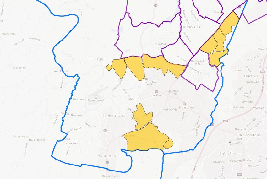
2 CAMDEN
District South West
LGA Camden
Vision
In year 2040, the Camden Local Government Area is a dynamic, modern, urban place which is defined by
its unique history and rural backdrop, and has realised the many opportunities presented by urban
development and population growth.
Camden 2040.
http://www.camden2040.com.au/assets/pdf/11_FINAL_Camden_2040_Adopted_14_May_2013.pdf
Key Issues
Actively manage growth
Funding and delivery of infrastructure and services as Camden is already “transport disadvantaged”
Retaining within Camden the valued heritage and characteristics.
Indigenous History
Camden 2040 (2013) notes that Camden sits at the intersection of three Aboriginal tribal boundaries. The
people of the Camden town location, western Cowpastures and adjoining mountainous areas are
Gundungurra. The eastern Cowpastures are Tharawal, and the people to the northeast of the Nepean
River are Dharug. Another tribe or sub-region of Aborigines in the Camden or Cowpasture area was called
Cubbitch Barha.
Jobs
Centres Camden is classified as a Town Centre. The Camden Town Centre Strategy was adopted in
2008.
http://www.camden.nsw.gov.au/assets/pdf/CamdenTownCentre/Camden-Town-Centre-
Strategy-with-Appendix-adopted-June-2008.pdf
An update to this strategy was commissioned in 2014, and adopted in December.
Narellan and Oran Park are noted in a range of Council strategies as being Town Centres and
Council is set to move to Oran Park from Camden in 2016.
Leppington falls within the LGAs of Camden and Liverpool. Leppington is a strategic centre,
and Oran Park as a retail centre. The role of existing Town Centres of Camden and Narellan
will require continued support.
http://www.camden.nsw.gov.au/assets/pdf/CamdenTownCentre/WEB-15-73062-Camden-
Town-Centre-Vision-Report-09-04-2015-.PDF
South West District 2
Employment The Camden Structure Plan (adopted 2000, amended 2003) identifies limited employment
Lands opportunities, and promotes mixed use zones and home businesses. The Plan recommends
that sites identified for ‘large land-take’ industrial uses are appropriate subject to an
environmental assessment.
The Structure Plan recommends that the Jacks Gully Waste Facility and Glenlee should be
explored for future employment opportunities. Rural employment opportunities should be
looked at in the rural lands strategy.
http://www.camden.nsw.gov.au/assets/pdf/Council/PublicationsPlansAndPolicies/Camden_
Structure_Plan_-_Central_Hills_including_amendment.pdf
The Camden Integrated Land Use and Transport Strategy (2006) recommends a mix of uses
in appropriate locations within residential areas It also recommends that public transport
and service accessibility be investigated to identify suitable locations for transit oriented
developments. It sets out a set of suggested processes around identifying future
employment areas and zoning appropriately, setting targets and so forth.
http://www.camden.nsw.gov.au/assets/pdf/Council/PublicationsPlansAndPolicies/Campbell
townCamden_Integrated_Transport_Strategy_2006.pdf
Retail The Camden Local Economic Development Strategy (2013) identifies key retail centres of
Oran Park, Camden, Narellan, Leppington (EDS 2013). The EDS (2013) notes that meeting
demand for floorspace will be a challenge while ensuring village-style main streets are
retained.
Camden 2040 notes a key economic objective of developing and sustaining vibrant town
centres with their own identity that provide a range of employment, leisure and social
opportunities. Specifically, it aims to provide suitable and sufficient land through the urban
planning process to attract enable and support a diversity of employment and industry
types, including planning for clusters or hubs to maximise opportunities.
http://www.camden.nsw.gov.au/assets/pdf/Council/PublicationsPlansAndPolicies/13_16341
__Economic_Development_Strategy_Adopted_9_July_2013.pdf
Other Addressing the increasing gap between the number of residents and the availability of jobs
within the region is an issue. The Narellan Town Centre expansion Stage 1 DA approves an
increase in size from 35,000m2 to 68,000m2 (construction has commenced) and further
upgrades to 95,000m2.
Attracting industry and business investment in the Camden and Macarthur regions is an
important strategic focus for the LGA.
Other elements identified under the Camden Local Economic Development Strategy 2013
include:
61% of working residents travel outside of the area for work and that this gap is likely to
continue. For Camden, a key challenge is reducing long journeys to work
Less available land for agriculture, plus increased pressure on access to fresh local goods
and maintaining visitor appeal is going to affect local business
Council plans to activate public and private underutilised spaces through planning and
development, and support the expansion of existing business and industry. They also
want to attract new business and industry, and maintain and develop the rural lifestyle
setting.
South West District 3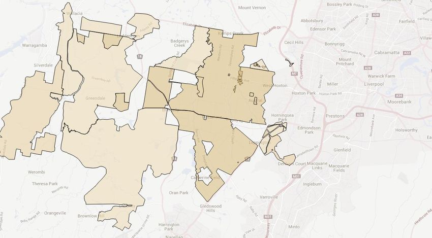
http://www.camden.nsw.gov.au/assets/pdf/Council/PublicationsPlansAndPolicies/13_16341
__Economic_Development_Strategy_Adopted_9_July_2013.pdf
Housing
Local Housing The Camden Residential Strategy (2008) is at a high level, and provides a range of locational
Strategy criteria around potential renewal opportunities. The criteria recommended in the Strategy
focuses on renewal in areas of lower quality housing stock, high amenity locations,
accessible locations and sites with dual frontages. Potential opportunities were also
identified such as:
Mixed residential and commercial development in town centres, such as shop top and
apartment style living above commercial development in Narellan, Camden and Oran
Park Town Centres
Housing opportunities for seniors
Limited expansion of large lot residential housing areas outside of the South West Growth
Centre.
The Camden Local Economic Development Strategy (2013) promotes development of
executive residential areas as a way of encouraging economic development.
The Camden Town Centre Strategy (2008) notes that medium density residential
development could be appropriate within the town centre (see link below).
http://www.camden.nsw.gov.au/assets/pdf/Council/PublicationsPlansAndPolicies/camden_
residential_strategy_final_april_2009.pdf
Recent Re- Lot 51 DP 1134649 at Gregory Hills. Rezoning from SP2 Infrastructure to R1 General
Zonings Residential. Approved by Minister or Delegate in February 2015
http://leptracking.planning.nsw.gov.au/PublicDetails.aspx?Id=1655.
Not a rezoning, but a DA at 1-5 Main Street, Mount Annan – for 246 units. Mix of 1, 2 and
3 bedroom units. Significant community opposition. Currently under assessment
http://www.camden.nsw.gov.au/development/major-developments/1-5-main-street-
mount-annan/
Leppington Priority Growth Area Precinct Stage 1.
http://www.planning.nsw.gov.au/en/Plans-for-Your-Area/Priority-Growth-Areas-and-
Precincts/South-West-Priority-Land-Release-Area/Leppington
Affordable Camden 2040 supports increased housing diversity to meet existing and future community
Housing needs. No future strategies, policies or objectives.
Priority Camden contains approximately half of the South West Priority Land Release Area. The
Growth Areas precincts include:
(Greenfields) East Leppington
Leppington North
Leppington
Catherine Fields
Catherine Fields North
Lowes Creek
Marylands
Oran Park
Rossmore
South West District 4
Turner Road.
Oran Park and Catherine Fields are currently being developed.
Release areas that are in the development phase outside of the Priority Land Release Area
include Elderslie Estate and Spring Farm.
Other smaller greenfields development is occurring in the scenic hills corridor to the east of
the Camden Valley Way.
Furthermore, the Western Sydney Infrastructure Plan involves major road and transport
linkages that will capitalise from developing an airport at Badgerys Creek.
Council led urban release areas are shown in yellow below. The South West Growth Centre
precinct are outlined in purple.
Urban No specific urban renewal opportunities have been identified.
Renewal
General Infill Camden 2040 notes the objective of ensuring greater choice and diversity in housing to
meet a range of existing and future community needs.
Sustainability
Liveability Camden 2040 focuses on the need to maintain liveability in the face of significant growth.
This is addressed through infrastructure and service delivery to develop strong communities,
not just suburbs.
Open Space The Camden Local Economic Development Strategy (2013) notes that with a growing
population, adequate, accessible and high quality open and public space must be made
available in new release areas, particularly where higher density housing is planned
A Sportsground Strategy was adopted in 2014, but does not include any maps of assets or
open space (see link below)
South West District 5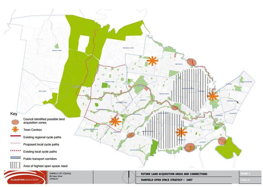
The development of the Camden Sportsground Strategy 2014 identified the need for
additional netball courts as well as additional sports grounds to conduct sports such as
athletics, to cater for the growth in the Camden area. In addition, the 2014 Camden
Recreation Demand Study identified the development of a new netball complex as one of
the top 10 priorities to cater for growth in Camden. Council has endorsed a masterplan
for the development of the Narellan Sports Hub.
http://www.camden.nsw.gov.au/assets/pdf/Council/PublicationsPlansAndPolicies/2015/Fin
al-Adopted-Camden-Sportsground-Strategy-2014.pdf
High A Biodiversity Strategy was adopted in 2013.
Environment
Value http://www.camden.nsw.gov.au/assets/pdf/Environment/Biodiversity/2014/camden_biostr
ategy_final_20130607.pdf
Hazards There is bushfire prone land in the LGA. The link below indicates the location.
http://www.camden.nsw.gov.au/development/plans-and-policies/development-guidelines-
and-policies/bush-fire-prone-land/
Information of flood catchment for the Nepean River, Upper South Creek, and Narellan River
is found in the link below.
http://www.camden.nsw.gov.au/environment/water/flood-information/
Salinty and saline-prone land is present in the LGA, no map available. They are controlled by
DCP control.
Mine subsidence is present from the South Campbelltown mine as shown in the DCP.
Rural Camden 2040 notes that Camden’s rural setting, and trees, parks and natural open spaces
are significantly valued by the residents
Key challenges include managing the impacts of loss of rural land and farming activities
on food supply, and the increased production pressure on remaining agricultural lands.
South West District 6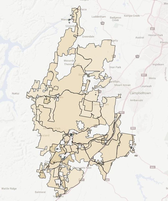
3 CAMPBELLTOWN
District South West
LGA Campbelltown
Vision
A connected community with opportunities to grow in a safe and sustainable environment.
Campbelltown’s Community Strategic Plan 2013-23.
.http://www.campbelltown.nsw.gov.au/Assets/5738/2/zCSP2013LR.pdf
Key Issues
Ensuring infrastructure keeps pace with population growth
Protecting the unique environmental context
Promoting Campbelltown as a regional city to encourage business to the local area
Encouraging more local jobs to reduce the proportion of residents travelling outside of the LGA for work.
Indigenous History
The CLEP 2015 aims to identify, conserve and protect the Aboriginal, cultural and natural heritage of
Campbelltown and minimise any adverse impacts of development on heritage items and conservation areas.
The Campbelltown Local Planning Strategy (2013) as amended notes the following strategies for preserving
and enhancing Aboriginal cultural heritage.
Awareness/Education/Promotion
Development of an enhanced understanding of local indigenous heritage, balanced against unnecessary
disclosure
Promote appropriate arrangements to facilitate access to cultural places, whilst safeguarding landholders'
rights.
Management
Involve traditional land owners and custodians in the management of their cultural heritage.
Planning Controls/Decision Making
Land use decision making should protect, and be consistent with, the cultural significance of landscapes
and places
Ensure indigenous heritage significance is maintained or enhanced by the heritage provisions of the new
Comprehensive Campbelltown LEP (CLEP 2015)
Ensure any rezoning of growth nodes and/or land for other development purposes adequately balances
growth demands with the conservation of indigenous heritage significance.
Jobs
Centres Campbelltown-Macarthur is identified as a strategic centre in A plan for Growing Centre.
The CLEP 2015 aims to facilitate the development of Campbelltown as the primary business
centre for the Macarthur Region with distinct limits to urban growth and clear separation
between urban and non-urban areas.
The CLEP 2015 aims to reinforce a hierarchy of centres and reinforce the role of Campbelltown-
Macarthur Centre as the primary business centre for the region. The Residential Development
Strategy (2013) as amended notes the following centres:
South West District 7Major Centres
Campbelltown/Macarthur
Ingleburn
Glenfield (potential).
Minor Centres
Leumeah
Minto (including Minto Mall), and
Macquarie Fields Station.
The local service centres identified in the Campbelltown Local Planning Strategy (2013) as
amended were recommended to be zoned B2 (Local Centre) and should integrate with medium
density residential transitionary development zoned R3 (Medium Density Residential).
Minto Mall
Macquarie Fields (Glenquarrie)
Eaglevale.
http://yourcityyourfuture.com.au/DraftCLEP2014
Employment The draft Campbelltown Employment Lands Review was prepared in 2011 to inform CLEP 2015.
Lands It was adopted, in part.
Key findings include:
741 ha of zoned employment lands in Ingleburn, Minto, Campbelltown and Leumeah
industrial areas, accounting for 5% of Sydney’s employment lands
At the time of the review, there were 30 ha of vacant land mostly around Minto industrial
area
66% of Campbelltown’s resident labour force commutes outside of the LGA for work.
It is estimated the LGA needs approximately 10 ha of additional land for employment per
annum to 2036 (250 ha in total)
A total of 1000 ha of zoned employment land for non-business park activities are needed
Two sites: Glenlee Coal Washery Site and Glenfield Waste Disposal Site are identified as
future potential employment lands and are being advanced as planning proposals
The following job targets are documented:
Campbelltown-Macarthur Centre 35,000
Campbelltown Business Park 10,000
Campbelltown Employment Lands 30,000
Other 31,600.
http://yourcityyourfuture.com.au/draftCLEP2014/documents/13642/download
Retail The CLEP 2015 encourages shop top housing in Local Centres zoned B2. It also allows for
residential development via mixed use development in the Campbelltown-Macarthur City
Centre via Zone B3 Commercial Core. Zone B4 Mixed Use aims to encourage timely renewal
and revitalisation of centres that are undergoing growth or change. This zone also encourages
mixed use buildings which include residential.
The hierarchy of centres is reinforced in CLEP 2015 and future opportunities of the main rail
based centres flagged in the Glenfield to Macarthur Urban Renewal Corridor Strategy.
Other Campbelltown is part of the Macarthur Regional Organisation of Councils.
South West District 8Housing
Local Housing The Campbelltown LEP2015 was gazetted on 11 December 2015 and will become operational
Strategy on 11 March 2016
The CLEP 2015 aims to ensure diverse housing opportunities are provided, including those
which accord with urban consolidation principles
A background document to the CLEP 2015 is the Campbelltown Residential Development
Strategy (2014)
The subject strategies are currently under review to address the significant emergent urban
renewal and greenfield housing opportunities in the form of the Glenfield to Macarthur
Urban Renewal Corridor (GMURC) and Greater Macarthur Land Release Investigations.
http://yourcityyourfuture.com.au/draftCLEP2014/documents/13978/download
Recent Re- Menangle Park release area – Potential for 3,500 dwellings. Approved at Gateway. Completed
Zonings public exhibition. It is awaiting resolution of subregional transport matters, principally in the
form of funding of the residue Springfarm Parkway elements including ramps to the F5
Freeway and the upgrade of Menangle Road
Mt Gilead release area – Potential for 1,500 dwelling neighbourhood as a greenfield
extension to the Campbelltown urban area. Approved at Gateway, completed public
exhibition and awaiting resolution of arterial road (Appin Road) upgrade. The Release area is
noted to form part of the GMLRI area
http://leptracking.planning.nsw.gov.au/PublicDetails.aspx?Id=823
“Maryfields” 168-192 Narellan Road, Campbelltown – rezone 44 ha lot for a range of uses
including residential. Potential for 620 dwellings and 1,000 jobs. Approved at Gateway and
with RPA for implementation
http://leptracking.planning.nsw.gov.au/PublicDetails.aspx?Id=1683
Several other planning proposals for residential development are currently before Council
including lands in environmentally sensitive locations.
Affordable The Campbelltown Residential Development Strategy (2014) notes the following actions to
Housing address housing affordability:
The key is supporting/facilitating affordable “entry level” housing
Ensuring enough land is zoned for residential uses
Encouraging compact medium density and high density development in areas with good
access and connections
Promotion of secondary dwellings.
Priority Campbelltown includes parts of the Edmondson Park and East Leppington precincts in the
Growth Areas South West Priority Land Release Area. The precincts incorporated into the Greater Macarthur
(Greenfields) Land Release Preliminary Strategy that was released for exhibition on 22 September 2015
include Menangle Park and Mount Gilead. See the link below for further information regarding
the preliminary strategy.
http://www.planning.nsw.gov.au/Plans-for-Your-Area/Priority-Growth-Areas-and-
Precincts/Greater-Macarthur-Land-Release-Investigation
Other greenfield developments include Ingleburn Gardens, Glenfield Road and Blairmount.
Planned suburban fringe growth nodes (greenfield) are shown in Appendix E of the Residential
Development Strategy (2013) as amended on pages 36-41, and include Glenfield Road, Bardi,
Menangle Park, East Leppington, Gilead and Blairmount.
Urban Council notes on its website that it is working with DPE on the Glenfield to Macarthur Corridor
Renewal Strategy. http://www.campbelltown.nsw.gov.au/CorridorStrategy
South West District 9The draft Ingleburn Structure Plan has been prepared to guide redevelopment around the
Ingleburn centre. Public exhibition of the draft plan ended at the end of 2014. The salient
elements of the Structure Plan were revisited in the GMURC strategy.
http://www.ingleburnchamber.com.au/Resources/Documents/Draft%20Ingleburn%20Structure
%20Plan.pdf
Council has nominated Glenfield as a Priority Precinct (Campbelltown Local Planning Strategy
2014). The advancement of planning and development in Glenfield has been progressed as
part of the GMURC strategy.
General Infill The R3 Medium Density residential zone forms a largely transitionary residential area
between the centres and low density residential areas focussed on bus routes and high
amenity areas
High density residential is permitted via the Zone R4 in CLEP 2015. High density residential
development is encouraged in close proximity to centres and public transport hubs with a
view to maximising redevelopment and infill opportunities within walking distance of centres
Indicative dwelling yields achieved by infill development are listed in the Residential
Development Strategy (2013):
Campbelltown/Macarthur - 10,252
Glenfield - 2,140
Ingleburn - 2,983.
These yields are under review through the land use concept plans contained in the GMURC
Strategy.
Maps for the three centres are shown on pages 18-20 of the Campbelltown Residential
Development Strategy (2014). In addition, infill opportunities and precinct boundaries are also
mapped for Leumeah, Minto and Macquarie Fields on pages 22-24.
Planned suburban fringe growth nodes are shown in Appendix C and include Blairmont, Kearns,
St Helens, Airds/Bradbury, Ambervale, Claymore, Eagle Vale, and Rosemeadow.
South West District 10This figure should be viewed in the context of the more recent CLEP 2015 Centres Map and
related zoning maps and principal development standard controls.
Sustainability
Liveability CLEP2015 encourages high-quality, well-designed development that enhances and encourages a
safe and healthy environment.
Open Space The Campbelltown Local Planning Strategy (2013, as amended) notes that Council is currently
undertaking a review of its existing open space and community facilities, which is nearing
completion and will inform future planning and service delivery.
The following is an extract from the Campbelltown Local Planning Strategy.
“The Campbelltown LGA is currently considered to be well supplied with passive and active
recreational facilities, including three regional sports facilities that are clustered in open space
areas near the Campbelltown CBD (at Leumeah). Other sporting facilities covering diverse
recreational activities are dispersed throughout the LGA”.
High The CLEP 2015 aims to conserve and enhance the environmental, scenic and landscape
Environment values of land. It also aims to maintain, protect and improve the natural environment
Value including biodiversity and water resources
The Campbelltown Local Planning Strategy (2013, as amended) recognises that 66% of the
LGA has high and medium biodiversity value. Specific areas of high value include Georges
River Bushland, The Scenic Hills, East Edge Scenic Protection Lands.
Hazards The Campbelltown Local Planning Strategy identifies the following hazards present in the LGA:
Salinity
Geotechnical risk
Contaminated land
Effluent disposal on rural properties
Subsurface minerals and gases
Air quality
Flooding
Bushfire.
South West District 11Hazard Management Impacts
Flooding and bushfire are the prime order significant constraints. The other hazards tend to
be more readily managed
The more environmentally sensitive landscapes are zoned principally E3 and RE1 under CLEP
2015 whilst the E4 zone forms a transition between expansive residential areas and areas of
environmental sensitivity.
Rural Lands The CLEP (2015) aims to protect rural land, its agricultural potential and prevent its
fragmentation. It includes zoning provisions and minimum development standards
CLEP 2015 and the Sustainable City DCP aim to ensure residential development in non-urban
locations is sited and designed in harmony with its natural surroundings (see the link below)
The Campbelltown Local Planning Strategy (2013 as amended) notes that 19% of the LGA is
land used for rural purposes. Whilst there are few intensive commercial agricultural
enterprises, the main value of this land is its open pastoral landscape character. The Strategy
points to the absence of a strategy for agricultural lands.
http://www.campbelltown.nsw.gov.au/Assets/10449/1/Part4ResdientialDevelopmentwithinnnonUrbanLa
nd.pdf
Map
South West District 124 FAIRFIELD
District South West
LGA Fairfield
Vision
Fairfield City Plan 2012-2020.
We are Fairfield City- a welcoming, safe and diverse community where we are proud to belong, invest and
prosper.
http://www.fairfieldcity.nsw.gov.au/downloads/file/895/2012-2022_fairfield_city_plan.pdf
Key Issues
The following issues have been highlighted in the Fairfield City Plan 2012-2020.
Ageing population
The need for public transport that connects to major networks
More accessible community centres and facilities
The recognised need for more trees and bushland
Community wellbeing- the need to address social issues including breaking the poverty cycle
Lack of public transport.
Indigenous history
The following statement is contained in the Fairfield City Plan 2020.
For more than 30,000 years the land of our city has been home to Aboriginal people from the Cabrogal clan of
the Darug Peoples. These ‘first people of the land’ hunted and gathered burraga (bandicoots), numbats, koalas,
wallabies, burru (grey kangaroo), potoroos and wombats across the lands and fished for flathead, mullet,
turtle, mussels, oysters, yabbies, crabs, prawns and cobra worm in the local rivers and creeks. The arrival of the
First Fleet in 1788 heralded major changes in how our landscape was utilised.
http://www.fairfieldcity.nsw.gov.au/downloads/file/895/2012-2022_fairfield_city_plan.pdf
Jobs
Centres Fairfield contains no strategic centres in A Plan for Growing Sydney.
The centres hierarchy (under the Fairfield City Centres Study 2015) for Fairfield LGA includes:
Major Town Centre – Fairfield
Sub Regional Centre – Prairiewood, Bonnyrigg,
Specialist Centre - Cabramatta
Local Centre – Canley Heights, Canley Vale, Edensor Park, Fairfield Heights, Fairfield West,
Horsley Park, Greenfield Park, Smithfield, Villawood, Wetherill Park and Wakeley
Neighbourhood Centres – Various smaller neighbourhood centres servicing the local suburbs.
The IN1 General Industrial zone applies to industrial land in Wetherill Park, Smithfield, Fairfield
East, Yennora and Old Guildford. The IN2 Light Industrial zone contains Cabramatta, Canley Vale,
Fairfield East, Lansvale, Old Guilford, Villawood, Wetherill Park and Yennora.
South West District 13The B5 Business Development includes Cabramatta, Canley Vale, Fairfield East, Lansvale, Old
Guilford, Smithfield, Villawood and Wetherill Park. The B6 Enterprise Corridor applies to areas on
the edge of Cabramatta and Fairfield Town Centres.
The map below identifies the Major Centres, Town Centres, Village and Small Villages under the
Residential Development Strategy – East (draft 2009).
http://www.fairfieldcity.nsw.gov.au/upload/uwjte99335/Draft_Fairfield_RDS_2009_Final_4_0_K
ey_Issues.pdf
Employment The majority of employment lands within the LGA consists of industry zoned land. The Fairfield
Lands Employment Lands Strategy (2008) identified a total of approximately 839.6 ha of industrial
zoned land within the LGA. The majority of industrial land is located within Wetherill Park (603.9
ha), Fairfield East (65.1 ha) and Smithfield (45.6 ha).
Across the industrial precincts in Fairfield, the highest representation of land use types include
Light Manufacturing (24.9%), Freight and Logistics (25.1%) and Local Light Industry and Urban
Support (12.3%).
The Fairfield Employment Lands Strategy (2008) highlights the future demand for business or
technology parks with the development of Badgerys Creek Airport and the inclusion of better
public transport through the Western Sydney Employment Area.
http://www.fairfieldcity.nsw.gov.au/upload/opndz48412/FairfieldELS18308.pdf
Retail Fairfield City Centres Study (2015) identified the role of the following centres as major locations
for retail trade. In addition, targets have been identified for retail growth as detailed below.
South West District 14 Fairfield Town Centre (Major Centre) – No retail floor space cap applied in order to promote
this centre as the City’s Major Centre
Bonnyrigg (Sub Regional Centre) – Apply a retail floor space cap of 50,000sqm (excluding
showrooms and bulky goods premises)
Prairiewood (Sub Regional Centre) – The expansion of Stockland centre increased the overall
gross leasable area from 18,600 sqm to 41,106 sqm. The current approved FSR for the site is
0.61:1 which already exceeds the maximum FSR applicable under Fairfield LEP 2013 of 0.57:1.
Council will review the FSR cap for Prairiewood Town Centre in five years to determine if the
cap has had the desired effect of promoting development within the Fairfield Town Centre.
The Stockland centre has strengthened competitively due to the location on the Liverpool to
Parramatta T-Way
Cabramatta (Specialised Centre) – No proposed floor space cap as the centre is operates as a
specialist centre and not deemed to impact upon the promotion of Fairfield Town Centre as
the City’s major centre. Future development encouraged to occur within existing centre
boundaries.
http://bpweb.fairfieldcity.nsw.gov.au:8080/fccbps/public/2016/OUT_09022016_COM_AT.pdf
Other With the release of employment lands in the Broader Western Sydney Employment Area, freight
and logistics together with distribution and warehouse use will be the dominant employment
industries in the LGA. These industries will be attracted by the M4 and M7 and Badgerys Creek
Airport. Large sized parcels of both light and general industrial land need to be preserved in
order to effectively accommodate the future expansion of these growth industries.
Housing
Local Housing A draft residential development strategy for the east of the LGA underwent community
Strategy consultation in late 2014. The following link to the Council Report summarises the recommended
changes.
http://www.fairfieldcity.nsw.gov.au/upload/images/OUT%20Agenda%2014%20Jul%202015%20p
df.pdf
The eastern centres planned for housing growth include Fairfield, Cabramatta, Villawood,
Fairfield Heights, Canley Heights and Canley Vale.
Council has identified under the Strategy an additional 24,000 new dwellings by 2030. 60%
(14,400) of these dwellings will be located within the eastern part of the LGA and 40% (9,600) in
the west. The housing types will comprise of:
7,200 medium density
7,200 high density.
At a broad level, the strategy looks at where increased residential development may be
accommodated in Fairfield, Fairfield Heights, Fairfield East and Villawood. A Council Report
(2015) examined the potential for increased density in and around Cabramatta Town Centre. The
Report found insufficient capacity in the surrounding road network represents a constraint to
increased densities exist, and that blanket rezoning is not appropriate. Future development will
need to be guided by further planning and traffic management criteria.
Options for increased densities for community consultation are shown in the map at the end of
this summary.
Recent Re- LEP Amendments that have been determined:
Zonings 46 Derby Street, Canley Heights. Rezoning from R4 to B2, adjustments to FSR and 8m height
limit. Approved by Minister or Delegate
http://leptracking.planning.nsw.gov.au/PublicDetails.aspx?Id=1828
South West District 15 Additional use of residential flat buildings and multi dwelling housing at 13-21 Rossetti St,
Wetherill Park. With DP&E for final assessment
http://leptracking.planning.nsw.gov.au/PublicDetails.aspx?Id=1897
131 Polding St, Fairfield Heights. Rezoning from R3 to B2. Approved at Gateway and with RPA
for implementation
http://leptracking.planning.nsw.gov.au/PublicDetails.aspx?Id=1857
New principal development standard clause to vary minimum lot size provisions in narrow lot
areas in Cabramatta, Fairfield and Smithfield. With DP&E for final assessment
http://leptracking.planning.nsw.gov.au/PublicDetails.aspx?Id=1749
325 and 327 Hume Highway, Cabramatta. Rezoning from R2 to B5. Approved by Minister or
Delegate
http://leptracking.planning.nsw.gov.au/PublicDetails.aspx?Id=1694
Rezoning of various sites in Villawood and Fairfield for open space purposes. Approved by
Minister or Delegate
http://leptracking.planning.nsw.gov.au/PublicDetails.aspx?Id=1254
Reclassification of 18 Council owned sites from Community to Operational Land. Approved by
Minister or Delegate.
http://leptracking.planning.nsw.gov.au/PublicDetails.aspx?Id=1550
LEP Amendments that have received Gateway Determination include:
Removal of residential accommodation, commercial premises and industries from Clause 6.4
Floodplain risk management
Residential Development Strategy – East Stage 2: Planning proposal recently received Gateway
Determination to increase residential densities in 6 precincts throughout the eastern half of
the City.
Affordable The draft Residential Development Strategy notes that the use of R4 High Density Residential will
Housing allow for more affordable housing options through the use of the SEPP Affordable Rental
Housing 2009 in up-zoned precincts. Council identified that retail stress impacts 5,171
households.
Priority Not applicable.
Growth Areas
(Greenfields)
Urban The draft Residential Development Strategy (2009) identifies Cabramatta and Fairfield as
Renewal priorities for urban renewal. A link to the centre’s boundaries and uses is located here:
http://www.fairfieldcity.nsw.gov.au/upload/cjucf99792/Draft_Fairfield_RDS_2009_Final_6_2_Ca
bramatta.pdf
The Strategy (2009) notes that renewal of the commercial core should occur through public
domain improvements and the DCP.
A corridor along the railway line towards Canley Vale is also identified as a medium to long term
renewal opportunity.
Short to medium term priority renewal areas:
Villawood.
http://www.fairfieldcity.nsw.gov.au/upload/mjnne63515/Draft_Fairfield_RDS_2009_Final_6_6_V
illawood.pdf
Medium term priority urban renewal areas:
Fairfield Heights
Canley Heights.
http://www.fairfieldcity.nsw.gov.au/upload/buqos36995/Draft_Fairfield_RDS_2009_Final_6_4_C
anley_Heights.pdf
South West District 16Long term urban renewal areas:
Canley Vale.
http://www.fairfieldcity.nsw.gov.au/upload/evnvq99389/Draft_Fairfield_RDS_2009_Final_6_3_C
anley_Vale.pdf
Bonnyrigg Town Centre is currently a Deferred Matter under Fairfield LEP 2013. A review of the
Deferred Matter is nearing completion and due for consideration by Council in March 2016. The
review will provide directions on rezoning of land in the town centre under the NSW Standard
LEP and new controls for future development included residential apartments.
Bonnyrigg Living Communities (Newleaf) – in 2015 Urban Growth NSW was contracted to move
forward with the construction of stages 4 - 6 of this State Significant Project for redevelopment
of the Bonnyrigg Housing Estate. The project includes increased residential densities, greater
housing diversity, new open space areas and improved infrastructure.
http://www.newleafcommunities.com.au/
http://majorprojects.planning.nsw.gov.au/index.pl?action=view_job&job_id=5111
General Infill The draft Residential Development Strategy identifies areas throughout the east of Fairfield for
infill development.
http://www.fairfieldcity.nsw.gov.au/upload/images/RDSE_Community%20Consultation_Informat
ion%20Sheet_Map%20of%20affected%20areas_Sept_2014(1).pdf
Other
Sustainability
Liveability The Fairfield City Plan (2012-22) Theme 1 focuses on Community Wellbeing. The goals outlined
in the plan are:
Sharing values and respect for our diversity, culture and heritage
Being healthy and active
Enjoying a good standard of living and enhanced quality of life
Being safe and law abiding
Increased opportunities for our community.
http://www.fairfieldcity.nsw.gov.au/upload/images/2012-
2022%20City%20Plan%20Final%20January%202013.pdf
Open Space The Open Space Strategy was last updated in 2007. Areas of open space are noted in the
following map (page 15 of the Strategy).
South West District 17Areas identified for acquisition by Council for open space are shown below as pink ovals:
The map above shows the areas of highest open space need in the LGA. These areas are
Cabramatta, Cabramatta West, Canley Heights, Fairfield, Fairfield Heights, and parts of Smithfield
and Fairfield West.
Accessibility to parks was identified as a key issue in the LGA, with the M7, major roads, rail lines
and creeks limiting pedestrian activity to open space.
http://www.fairfieldcity.nsw.gov.au/upload/veuib73732/FINALUSE2007_Open_Space_Strategy_F
inal20_Report.pdf
South West District 18The Western Sydney Parklands runs through the LGA and Bossley park and Cecil Hills. This
regional network of open space runs from Blacktown to Campbelltown LGAs.
High A Biodiversity Strategy was prepared in 2010. The Strategy classifies the LGA into areas of high,
Environment medium and low conservation values. 15.55% of the LGA falls into one of these three categories.
Value The assessment identifies that almost all native vegetation in the LGA is comprised of
endangered ecological communities listed under the NSW Threatened Species Conservation Act
1996. Over half of high conservation value areas are located in the Western Sydney Parklands.
However, the strategy does not focus on the Western Sydney Parklands as it is not in Council’s
care.
A map on page 37 of the Biodiversity Strategy identifies the areas of high, medium and low
conservation value across Fairfield.
Targets to 2016 for the City of Fairfield include:
30% of both sides of creeks banks rehabilitated to natural condition
50% of riparian zones revegetated
Over 75% of all creek water quality samples each year meet ANZECC guidelines for secondary
contact
75% of creek system is free of noxious and exotic weeds
50% of private land adjoining creeks are free of noxious and exotic weeds
Increase canopy cover of original bushland to 15%
Increase canopy of native bushland in public ownership by 5%
30% of LGA with tree canopy
Plant 30,000 indigenous trees, shrubs and ground covers per year.
http://www.fairfieldcity.nsw.gov.au/upload/kzskm22647/FairfieldBiodiversityStrategyexhibition.
pdf
Hazards Fairfield City is located on a number of floodplains. Council has a range of floodplain risk
management plans and has adopted planning controls covering flood prone land.
Bushfire prone areas are noted on the map. A review of bushfire prone areas was completed in
2015 with publication of the updated map due in mid-2016.
http://www.fairfieldcity.nsw.gov.au/upload/vlutq76688/Bush_Fire_Prone_Land_Map_RFS_Augu
st2003.pdf
South West District 19A small portion of land is identified in the LEP as being landslip affected, however this land falls
in the Western Sydney Parklands.
Land along Prospect Creek is identified as Class 5 acid sulfate soils.
Other
Rural Lands Areas of rural land are noted in the suburbs of Horseley Park and Cecil Park, but a specific rural
land strategy does not exist. The Council website notes that prior to NSW Government’s
identification of part of the City’s rural area as future employment lands that a rural lands study
had commenced. According to the website, this study was then put on hold until the findings of
the WSELIA become available. No recent information has been posted.
RU1 Primary Production, RU2 Rural Landscape, RU4 Primary Production Small Lots and RU5
Village. Location of rural lands is to the west of Abbotsbury.
http://www.fairfieldcity.nsw.gov.au/default.asp?iNavCatId=51&iSubCatId=301
Map Housing map indicating areas of increased density under the draft Residential Development
Strategy (see below).
South West District 205 LIVERPOOL
District South West
LGA Liverpool
Vision
Liverpool, a vibrant historical regional city of growth, prosperity and diversity.
Growing Liverpool 2021.
http://www.liverpool.nsw.gov.au/__data/assets/pdf_file/0019/3646/LCC-Growing-Liverpool.pdf
Key Issues
Affordable housing. Three in every 10 homes in Liverpool are rented
Improved public transport and regional roads
Planning to ensure the culturally diverse community is recognised through appropriate supply of community
facilities and services, along with the preservation of heritage
Council considers Liverpool a young LGA, but by 2036, it is expected that Liverpool will be home to nearly
50,000 people aged over 65
Liverpool is car dependent with more households owning two or more vehicles.
Indigenous History
Liverpool Council acknowledges the original inhabitants of the Liverpool area, being the Darug, Gandangara
and Tharawal Aboriginal people. Collingwood Precinct has been officially named an Aboriginal Place.
Collingwood Precinct was a significant meeting place for the Dharawal, Gandangara and Dharug people and
with the Georges River nearby, a source of valuable natural resources.
http://www.liverpool.nsw.gov.au/community/our-community/aborginal-
people#PLACESOFAboriginalSIGNIFICANCE
Jobs
Centres Liverpool has two strategic centres as identified in A Plan for Growing Sydney:
Liverpool (regional city centre)
Leppington (which spans Camden and Liverpool Local Government Areas).
The hierarchy of centres in Liverpool is outlined under the Liverpool Business and Corridors
Strategy 2013.
South West District 21Liverpool also contains the transport gateway for the proposed Western Sydney Airport at
Badgerys Creek as identified in A Plan for Growing Sydney.
http://www.liverpool.nsw.gov.au/planninganddevelopment/strategic-planning/liverpool-retail-
centres-hierarchy-review-2013
Employment The Liverpool Business Centres and Corridors Strategy Review (2013) identified a number of key
Lands employment lands within the LGA (listed above).
Liverpool City Centre Plan (2007) is a 25 year plan to facilitate 15,000 new jobs for one city
centre. Liverpool City Centre will continue to operate as a Regional Centre, serving the South
West. Council is working to implement strategies (listed below) to ensure Liverpool City Centre is
the ideal location for commercial office development.
30,000 jobs by 2036
The majority of commercial development will be concentrated around the public transport
interchange. Ideal locations for commercial development within the core area include Bathurst
Street, Memorial Avenue and Elizabeth Street.
Crossroads Homemaker Centre located at Parkes Farm Place, Casula, provides approximately
58,000sqm of bulky goods floor space, making it the largest Homemaker centre in NSW. Costco
has recently developed at the precinct, supplying an additional 13,000sqm of retail floor space.
The Liverpool City Centre Plan (2007) identified that the Shepherd Street industrial precinct
accommodates residential development in the near future. Residential planning controls were
incorporated for this area in the Liverpool City Centre LEP 2007.
South West District 22Planned centres include Middleton Grange, Edmondson Park and Austral and Leppington North
and will each supply retail, commercial and community uses (greenfield delivery).
Under the Liverpool Business Centres and Corridors Strategy Review (2013), Council has adopted
the following strategies:
Preserve a commercial core area (excluding residential) in the Liverpool CBD for future
business, office and retail growth
Limit professional office premises to business zones to capitalise on, and concentrate
infrastructure and services
Establish and maintain Liverpool’s Retail Centre Hierarchy
Support the expansion of existing retail and business centres in accordance with the adopted
Retail Centres Hierarchy 2012
Ensure the new centres complement existing centres and do not impact upon their viability
Expand start-up business opportunities (and restrict residential) in extended enterprise
corridor zones leading into main centres and nodes
Support growth of existing bulky good clusters in accordance with the retail centre hierarchy
and limit other locations to serve a district role.
Retail The Liverpool Retail Centre Hierarchy Review (July 2010) found over the next 30 years, around
120,600sqm of additional retail space is proposed in the Liverpool LGA. Around 29% of this
(35,000sqm) would be accommodated within Liverpool City Centre.
Liverpool Council will continue to support opportunities to strengthen and consolidate the retail
offer of Liverpool City Centre as the Regional City for the South-West District. Council support
the expansion opportunities in Liverpool City Centre of up to 15,000sqm which could include the
provision of additional department store or discount department store floor space. Retail
development will continue to be focused around the Macquarie Street Mall and Westfield
shopping centre.
Planned centres within the Liverpool LGA supplying retail trade include Middleton Grange,
Edmondson Park and Austral and Leppington North. Middleton Grange is expected to be a town
centre of approximately 5,500sqm, including 500sqm of homemaker floor space. Edmondson
Park will be situated adjacent to the SWRL and will provide 45,000sqm of retail and commercial
floor space. In Austral there will be a Local Centre providing up to 30,000sqm with 1,000sqm in
each of the three neighbourhood centres.
Upon completion, Leppington Major Centre will accommodate 120,000sqm of retail, commercial
and bulky goods floor space, most of which will be in Camden LGA.
Council has made Amendment 19 to the LEP which increases the size of retail premises
permissible in the B6 Enterprise Corridor zone from 1,000sqm to 1,600sqm. As a result a number
of stores are likely to be developed on B6 land within the Liverpool LGA in the short, medium,
long term.
For further information regarding the Liverpool Retail Centre Hierarchy Review (July 2010), see
the link below.
http://www.liverpool.nsw.gov.au/planninganddevelopment/strategic-planning/liverpool-retail-
centres-hierarchy-review-2013
Other Liverpool City Centre Vision has identified the land east of the Georges River within the city
centre formerly owned by Pirelli, as an opportunity for further expansion of the city centre. It is
subject to environmental constraints, although capable of a large variety of land uses to
complement those already found within the city centre and additional high density housing.
South West District 23The map below identifies the location of Liverpool as the regional centre, the town centres,
villages and neighbourhood centres.
Leppington is a greenfield site in the LGA and has been identified as a major centre.
The table below illustrates the 10 town and village retail hierarchy of floor space to 2031.
http://www.liverpool.nsw.gov.au/planninganddevelopment/strategic-planning/liverpool-retail-
centres-hierarchy-review-2013
South West District 24Housing
Local Housing Council’s initial housing estimates were about 7,000 new dwellings through development of
Strategy existing urban areas and 4,000 through greenfield development outside the SWGC. Liverpool
Residential Development Strategy (2008) provides strategies to achieve the 20,000 target and is
in a position to support growth.
Liverpool Residential Development Strategy (2008) outlines the mains strategies for Liverpool’s
residential land over the next 25 years:
Consolidate medium density residential zones to areas around activity centres (200-800m)
and major transport nodes and down-zone fringe areas
Introduce new high density residential zone nodes adjacent to main town centre and major
transport nodes
Investigate the surrounds (approximately 800m) of the 10 town and village centres (identified
above) and determine appropriate locations and extent of housing
Encourage affordable private housing types within medium density zones particularly around
the centres at Moorebank, Casula, Miller and Green Valley
Introduce new high density residential nodes, totalling 100ha in Moorebank, Casula, Miller,
Green Valley, Liverpool West, Liverpool North West, Cartwright, Chipping Norton and
Holsworthy
Provide generally for four and five storey residential buildings and three storey buildings on
any new interfaces with lower density zones.
http://www.liverpool.nsw.gov.au/planninganddevelopment/strategic-planning/liverpool-
residential-development-study
Recent Re- New Brighton Golf Course, Moorebank - permit residential development of 310 dwellings and
Zonings continue golf course operations. Approved and gazetted in 2013
http://leptracking.planning.nsw.gov.au/PublicDetails.aspx?Id=548
Tree Valley Golf Course, Edmondson Park – rezone part of the site for low and medium density
development. Potential capacity for 54 dwellings. Approved and gazetted on 20 March 2015
http://leptracking.planning.nsw.gov.au/PublicDetails.aspx?Id=1207
900 Cowpasture Road, Cecil Hills – rezone land for low density residential. The site is
30,000sqm. Approved at Gateway and with RPA for implementation.
http://leptracking.planning.nsw.gov.au/PublicDetails.aspx?Id=1993
Affordable Three in every 10 homes are rented
housing Nearly 8% of all homes are public housing residents, compared to the Sydney average of 5%
People on low incomes in the private rental market find it difficult to secure suitable housing
Accessibility to the Liverpool market for low income households is declining in the face of high
demand for affordable housing.
Priority Precincts that have been released within the Liverpool LGA in the South West Priority Land
Growth Areas Release Area include:
(Greenfields)
Edmondson Park
827 ha site bounded by M5 freeway to the south and east, Camden Valley Way to the north
and Zouch Road to the west
Anticipated that the area will provide 6,706 dwellings for 25,000 people
The Town Centre will be built around a future bus/rail interchange which commences
operation in early 2016.
Austral and Leppington North
South West District 25 17,350 homes, ranging from units, terraces, detached homes and rural residential
Leppington Major Town Centre and Railway Station, mostly within Camden LGA.
East Leppington
Located south east of Leppington Major Centre
Estimated 3,000 new dwellings.
Precincts in the South West Priority Land Release Area yet to be released include Lowes Creek
and Marylands (Part).
Precincts in the South West Priority Land Release Area will look at opportunities for new jobs,
homes and services adjacent to the planned Western Sydney Airport at Badgerys Creek in the
Western Sydney Priority Growth Area.
The Western Sydney Infrastructure Plan involves major road and transport linkages that will
capitalise from developing an airport at Badgerys Creek. Including upgrades to Bringelly Road,
The Northern Road and the new Elizabeth Drive Motorway.
Urban Key sites have been identified for the development under The Liverpool City Centre Plan (2007)
Renewal to facilitate development opportunities within the Liverpool City Centre.
The site at Elizabeth Street, adjacent to the retail core and on the edge of the commercial
precinct may also be developed for commercial offices combined with ground floor retail uses.
The site on George Street between Moore Street and Railway Street and the entire Railway
Street block may be redeveloped to accommodate significant commercial, residential and
potentially educational activities. The New Bridge Road site may be suitable for commercial and
residential purposes. Planning controls have been initiated to assist the industrial area on
Shepard Street be developed.
http://www.liverpool.nsw.gov.au/planninganddevelopment/strategic-planning/Liverpool-City-
Centre-Vision
General Infill Several locations identified under Liverpool City Centre Vision including the Railway Street block,
New Bridge Road and Shepard Street.
Sustainability
Liveability No liveability statement. Strategy 3 of the Community Strategic Plan states urban development is
consistent with sustainability principles which is consistent with Strategy 4 identifying Liverpool
as a socially inclusive and health community.
Open space Over 250 parks and green open spaces within the LGA
Open space accounts for 5% of land within the Liverpool City Centre
Growing Liverpool 2023 is a strategy to maintain the attractive amenity of open space
Council has several plans for management to ensure that an endorsed framework guides the
operation and development of community resources.
Open space within Liverpool city is identified in the map below.
South West District 26Open space zoned E1, E2, E3 and RE1 and RE2 under the LEP 2008.
http://www.liverpool.nsw.gov.au/whats-on/Sports-and-Leisure/plans-of-management
High E1 National Parks and Nature Reserves land is located between Denham Court and Edmondson
Environment Park and land south of Casula, along the Georges River. Local biodiversity and communities are
Value mapped by council and controlled through the LEP and DCP.
Hazards Bushfire and flood prone land, particularly on the Wollondilly boarder of the LGA.
South West District 27Other
Rural Lands Rural residential
Recent market desire for large residential housing on large lots with a semi-rural character. Such
is occurring in Denham Courts rural residential zone and the prominent use of 2 ha small rural
lots solely for residential, indicates there is a market for this type of housing. Council’s position is
it is important for Liverpool to have land available for rural residential but limited enough for it to
be exclusive.
Opportunity for future Rural Residential Development within western portion of Liverpool is
limited due to the identification of large areas of land within the future urban areas of the
SWGC. As such, rural residential development is only possible in the very westernmost areas of
the LGA including the existing 2 ha subdivision at Wallacia and Bringelly.
Rural lands
Most of the rural lands are located in the Greenfield precincts. There is a large amount of RU1
Primary Production. Predominately west of the LGA around Leppington. The location of RU1,
RU2, RU4 are illustrated in the map below.
A current Council study updates the previous RLS with consideration to the Badgerys Creek
Airport reservation and detailed Precinct Planning. Detailed maps are included in the Strategy
which show key rural issues. Overall, the RLS aims to balance the uses of rural lands, such as
primary production, extractive industry, recreational pursuits and scenic qualities while allowing
reasonable levels of development.
http://www.liverpool.nsw.gov.au/trim/documents?RecordNumber=275056.2013
South West District 286 WOLLONDILLY
District South West
LGA Wollondilly
Vision
Rural living
Wollondilly Community Strategic Plan 2033.
http://www.wollondilly2033.com.au/assets/pdf/July_2013_New_CSP_2013_web.pdf
Key Issues
Land use conflicts with urban development encroaching on rural land
Preservation of Sydney’s food bowl
Infrastructure to support growing population such as educational institutions and primary health care
services
Quality of existing roads and commute times
Masterplanned estates developing new growth and infrastructure investment away from established areas
Providing a range of housing diversity including residential flats, secondary dwellings, townhouses, seniors
living and shop top housing
Challenges arise from a relatively low population and dispersed and varied towns and villages.
Indigenous History
The Community Strategic Plan notes that the district is rich in Aboriginal and European history. The earliest
known inhabitants of the district were the Gundangurra Tribe, who gave the area its name. The Community
Strategic Plan acknowledges the values of the towns and villages of Wollondilly LGA for their heritage, their
rural character, their sense of place, and the opportunities they provide for living, working, recreation and
social interaction.
Jobs
Centres No Strategic Centres as identified in A Plan for Growing Sydney
Under the Growth Management Strategy 2011, the following strategic centres have been
identified.
Town Centre- Picton, Tahmoor
Village Centre- Appin, Bargo, The Oaks, Thirlmere, Warragamba
Neighbourhood Centre- Buxton, Douglas Park, Menangle, Oakdale, Belimbla Park (The Dome)
and Silverdale.
Wollondilly Council has identified the Macarthur South area for a potential business park.
Strategic planning for the Macarthur South region is currently being conducted.
The Greater Macarthur Land Release Investigation Preliminary Strategy and Action Plan advises
that the Wilton Priority Precinct is envisaged to have a major centre at West Wilton, being the
main employment contributor to the Greater Macarthur area, and a village centre at Wilton.
Employment The Growth Management Strategy 2011 notes that rural residential and environmental zones
Lands dominate the LGA. Under the Wollondilly LEP 2011, the rural lands are zoned RU1 Primary
Production, RU2 Rural Landscape and RU4 Primary Production.
South West District 29You can also read