Appendix 8 Green Infrastructure Strategy - Louth County Council
←
→
Page content transcription
If your browser does not render page correctly, please read the page content below
Appendix 8

Green Infrastructure Strategy

                                Page 1 of 46
Appendix 8
Green Infrastructure Strategy
Appendix 8
                                   Green Infrastructure Strategy

GREEN INFRASTRUCTURE STRATEGY

1.1 GREEN INFRASTRUCTURE DEFINITION
Green infrastructure (GI) is a network of            Louth. In addition to this, it will provide
green spaces that help conserve natural              support for a strategic network of natural
ecosystems and provide benefits to                   and semi-natural areas interconnected,
human populations through water                      designed and managed to deliver a range
purification, flood control, carbon capture,         of ecosystem services. The GI strategy
food production and recreation. Such                 incorporates green spaces and blue
spaces include woodlands, coastlines,                spaces (water based) such as those in
flood plains, hedgerows, city parks and              Figure 1, both in urban and rural areas to
street trees.                                        support a resilient society.
This strategy aims to assess the current
environmental baseline within County

Figure 1: Natural Features Making Up Green Infrastructure

                                    Open                           Hedges
                     Gardens        Space
                                                   Village
                       and
                                                   Green
                      urban                                         Church
                      farms                                          yards
    Moorland                                                                        Ponds

         Degraded                                                             Coastal
           Land                                                               habitats
                                          Green
          Agricultural                Infrastructure
             land                                                            Heathland

                                                                      Waterways
      Allotments             Private
                             gardens
                                                    Rivers
                                                                   Lakes
                                      Street
                                      Trees

                                                                                    Page 1 of 46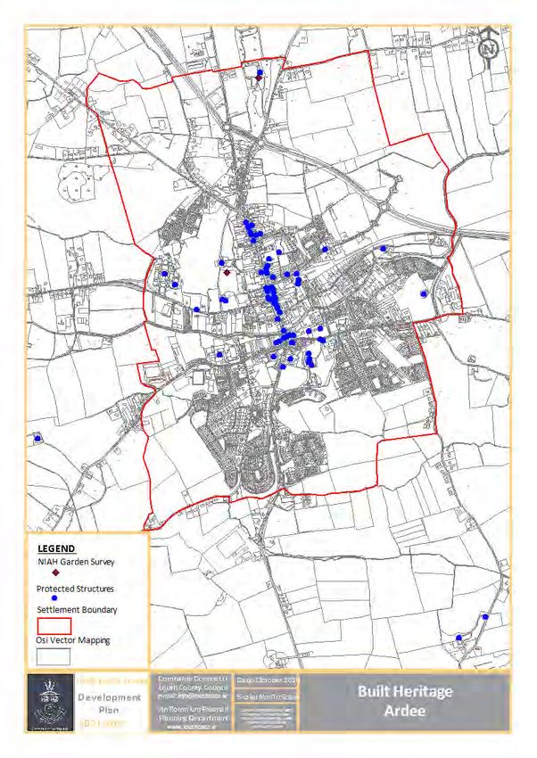
GI composed of an Ecological Network                          vegetation, such as hedgerows, strips
(EN) which consists of core areas (or                         of forest and other vegetation which
hubs), corridors, stepping stones and                         facilitates to allow the movement of
buffer zones where the corridors and                          wildlife between the two core areas.
stepping stones create a connection                           Stepping stones are also corridors
between constituent core areas (Figure 2).                    made up of a series of small, non-
These may be described as outlined                            connected habitats.
below.                                                    - Buffer Zone: These surround areas of
 - Core Areas: These areas consist of the                     ecological value to minimise the
    central most important ecological                         impacts of adjacent land use on these
    areas which support important or                          ecologically important areas.
    vulnerable species and habitats for                  The Green Infrastructure Strategy
    e.g. Natura 2000 sites.                              provides support for all such aspects of
 - Ecological Corridor: These are also                   this ecological network as illustrated in
    referred to as landscape or linear                   Figure 2.
    corridors and include long strips of

Figure 2: Indicative Illustration of Green Infrastructure within the Landscape

Source: “Green Infrastructure, A Quality of Life Issue” (IEEM & Urban Forum

                                                                                       Page 2 of 46
Appendix 8
Green Infrastructure Strategy
1.2 NATIONAL GUIDANCE FOR GREEN INFRASTRUCTURE STRATEGY
Since the adoption of the Louth County and Regional level, requiring Green
Development Plan 2015-2021, the GI Infrastructure and ecosystem services be
concept is now more widely considered, incorporated into the preparation of
promoted and implemented at National statutory county and city plans.
1.3 NATIONAL & REGIONAL CONTEXT
1.3.1 Project Ireland 2020 – National Planning Framework
The National Development Plan land use plans, whereby: Growth is
recognises that the environment is an accommodated while retaining the
asset that can, if properly planned provide intrinsic value of natural places and
long term benefits for all and in this assets; environmental issues are
regard the NPF aims to protect and proactively addressed, interaction
strengthen the interrelationship between between future development and the
our habitats, natural and cultural heritage, capacity of the receiving environment is
landscapes and green spaces. In examined; and where sufficient green
acknowledgement of this, and in achieving spaces are designated in plans
its goals as expressed as National Strategic commensurate to long term development
Outcomes (NSO), the NPF requires the requirements. Linkage and integration
incorporation of integrated planning for with the built and cultural heritage which
green infrastructure and ecosystem helps define the character of urban and
services in the preparation of statutory rural areas is also recognised.
1.3.2 National Biodiversity Action Plan, 2017-2021
The National Biodiversity Action Plan targets and actions for biodiversity
(NBAP) recognises that GI is crucial to objectives that will be undertaken by a
achieving biodiversity targets and wide range of government, civil society
developing ecological corridors that allow and private sectors to achieve Ireland’s
the movement of species through their vision for biodiversity. The NBAP provides
entire natural habitat. Its objectives, a framework to track and assess progress
targets and actions seek to achieve towards Ireland’s vision for biodiversity
Ireland’s vision for biodiversity through over a five-year timeframe from 2017 to
the implementation of seven specified 2021.
strategic objectives. It links the associated
1.3.3 Creating Green Infrastructure for Ireland
In general, the Comhar guidelines provide Eight functions of green infrastructure
strategic guidance on the implementation have been identified:
of GI at a national and regional level. Recreation and health,
Examples of data sets and case studies Biodiversity and Natural Resources,
have been provided with support for an Coast, Water Resource and Flood
integrated approach to the delivery of GI Management,
Page 3 of 46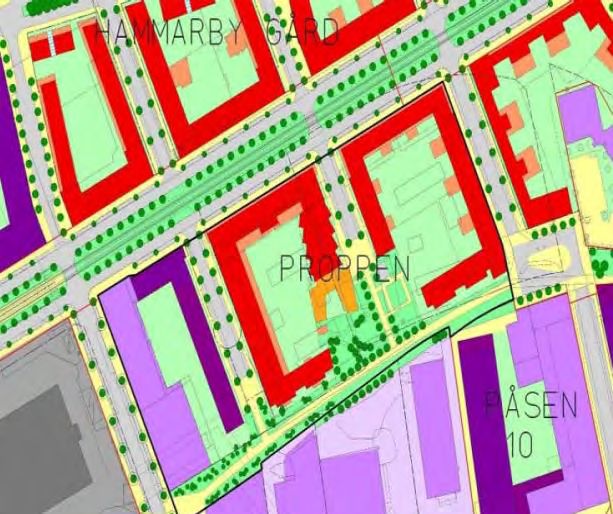
Appendix 8
Green Infrastructure Strategy
Sense of Place, Social Inclusion and
Climate Change Adaptation and Production Environments.
Mitigation,
Economic Development,
1.3.4 Green City Guidelines (UCD 2008)
The Green City Guidelines refer to the Size;
integration of a GI approach at a local Diversity;
level and include examples. Guidance is Naturalness;
listed for biodiversity in urban areas as Typicalness;
well as an overview of the planning and Rarity;
development process, case studies and Fragility and
practical measures for incorporating History
biodiversity at an early stage in the design
process. Key factors for defining habitat
quality include:
1.3.5 National Climate Change Adaptation Framework (2012)
This non-statutory framework was This framework also recognises the
Ireland’s first climate change adaptation importance of the role of planning and
framework providing a strategic policy development with full engagement of key
focus aimed to reduce Ireland’s stakeholders to deliver the climate change
vulnerability to climate change by objectives and adaptation action at a local
ensuring adaptation actions were taken level.
across key sectors at national and at a
local level.
1.3.6 Climate Action and Low Carbon Development Act 2015
This Act was a national landmark in the need to produce and submit for approval
development of climate change policy in to the Government a series of successive
Ireland and provides the statutory basis National Mitigation Plans (NMPs) and
for the national objective laid out in the National Adaptation Frameworks (NAFs)
National Policy Position to move towards to guide policy in relation to the reduction
and achieve a low carbon, climate resilient of GHG emissions and climate change
and environmentally sustainable economy adaptation.
by 2050. It brought about the compulsory
1.3.7 National Mitigation Plan (NMP) 2017
As instructed by the Climate Action and environment, Transport and agriculture as
Low Carbon Development Act 2015 Act the key sectors.
2015, the NMP is a whole-of-Government This is to achieve the national objective to
plan and is Ireland’s first plan in setting transition Ireland to a low carbon, climate
out a pathway to achieving the required resilient and environmentally sustainable
level of decarbonisation. It pinpoints economy by 2050. As per the Climate
electricity generation, the built Action and Low Carbon Development Act
2015, there will be successive mitigation
Page 4 of 46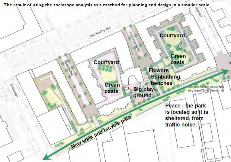
Appendix 8
                                   Green Infrastructure Strategy

plans prepared at least every 5 years                underway.
building on the foundation work

1.3.8 National Adaptation Framework (NAF 2018)
Developed under the Climate Action and               Local authorities are tasked with
Low Carbon Development Act 2015 Act                  addressing climate change at a local level
2015 this is Ireland’s 1st statutory national        through the preparation of local climate
adaptation strategy that builds on the               change adaptation strategies. 4 Local
work carried out under NCCAF??? 2012                 Authority Climate Action Regional Offices
and outlines a whole of Government and               (CAROs) were established in 2018 to drive
society approach to climate change                   climate action at regional and local level in
adaptation in Ireland. It aims to reduce             Ireland. They are each operated by a Local
the vulnerability of the State to the                Authority and support the preparation of
negative effects of climate change and to            local adaptation strategies.
avail of any positives effects that may
occur.
1.3.9 Climate Action Plan (CAP)
The Climate Action Plan is a Government              better and more confident position in
plan designed to enable Ireland to meet              realising and meeting their 2030 and 2050
its EU climate change commitments                    targets. Several key measures identified in
through carbon proofing government                   the plan have already been delivered
policies and establishing carbon budgets.            including the signing up of all 31 Local
It provides 183 individual policy actions            Authorities in Ireland to the Climate
over 12 sectors to tackle climate change             Action Charter (CAC). In 2019 the
along with timelines for delivery to reduce          Government approved the publication of
carbon emissions by 30% between 2021                 the General Scheme for the Climate
and 2030 and towards achieving zero                  Action (Amendment) Bill 2019. The Bill
emissions by 2050. The actions in this               aims to enshrine in law the approach
plan, if implemented, places Ireland in a            outlined in the CAP.
1.3.10         Climate Action Charter (CAC)
The Climate Action Charter for Louth was             We must plan and develop our County
signed in 2019. The charter acknowledges             with climate action including adaptation,
that climate change is happening and that            mitigation and improvement at its heart.
actions must be taken to mitigate and                As a Nation and County we must reduce
adapt to our changing climate. We as a               negative climate impacts and promote
Nation must be more sustainable in our               climate improvement/mitigation and be
actions and ensure that Climate Action is            climate resilient in our planning. The
at the heart of all our national, regional           actions detailed in the Charter underpin
and local strategies, policies, plans and            all policies, objectives, goals and
decisions. Each Chapter in this County               strategies of this plan and all other
Development Plan must be read with this              strategic plans whether they are local,
Climate Action Charter at its core.                  regional or national.

                                                                                      Page 5 of 46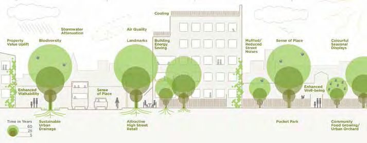
Appendix 8
                                   Green Infrastructure Strategy

1.3.11         Eastern and Midland Regional Spatial and Economic
               Strategy (EMRSES)
In seeking to achieve the National                   habitats, increased biodiversity, ecological
Strategic Outcomes as identified in the              corridors, climate change adaptation and
National Planning Framework, the                     mitigation and local amenity provision.
Regional Spatial and Economic Strategy               The importance of cultural heritage
(RSES) defined 16 Regional Strategic                 including the built environment is
Outcomes        (RSOs),     aligned     with         acknowledged as the fabric of our lives
international, EU and national policy and            and societies bringing communities
which set the framework for City and                 together and building a shared
County Development Plans. RSO No 10                  understanding of the places we live.
and 11, specifically address ‘Enhanced               Building     and     sustaining     cultural
Green Infrastructure’ and ‘Biodiversity              infrastructure is a core consideration of
and Natural Heritage’ respectively in                the RSES. Linking strategic natural assets
recognition of the importance of                     with cultural and built heritage assets
identifying, protecting and enhancing                further enhances the opportunities to
green       infrastructure,     biodiversity,        drive recreation and tourism benefits,
habitats, landscape and heritage to ensure           including      through      the      Green
the sustainable management our natural               Infrastructure Strategy.
heritage, to build climate resilience, to            The RSES identifies the Strategic GI and
support the transition to a low carbon               cultural heritage assets in the Region,
economy and the protection of a healthy              which in relation to Louth include for
natural environment with clean air and               Carlingford Lough, Clogherhead, Dundalk
water for all. Green Infrastructure is a             Bay, Boyne Coast and Estuary, the Rivers
strategically planned network of high                Boyne, Fane and Dee, the Cooley
quality natural and semi-natural areas               Peninsula, the medieval towns of
alongside other environmental features.              Carlingford and Drogheda and the walled
It serves a variety of functions including           towns of Drogheda, Ardee and Carlingford
but not limited to the provision of                  and the many Natura 2000 sites etc.

1.4 LOCAL CONTEXT
1.4.1 Louth County Council’s Climate Change Adaptation Strategy
      (CCAS)
This Adaptation Strategy forms part of the           Development Guidelines and was adopted
National Adaptation Framework (NAF)                  by Louth County Council elected members
which was published in response to the               on 16th September 2019. It is a
provisions of the Climate Action and Low             collaborative approach to climate change
Carbon Development Act 2015. Louth’s                 across the Eastern and Midlands Region.
CCAS has been developed in line with the             It sets out Louth’s measures to adapting
Department for Communities Climate                   and protecting its functional area and
Action & Environment (DCCAE) Local                   citizens from the current and future
Authority       Adaptation       Strategy

                                                                                     Page 6 of 46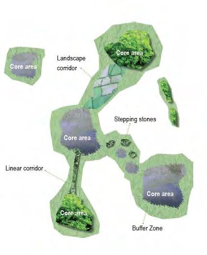
Appendix 8
                                  Green Infrastructure Strategy

effects of climate change and is based              The CCAS seeks to inform or ‘climate
around 6 thematic areas.                            proof’ existing plans and policies
They are supported by specific objectives           produced and implemented by Louth
and adaptation actions to achieve their             County Council.
desired outcomes.
1.4.2 Draft Louth Heritage Plan 2020- 2026
Specific reference has not been made to             GI Strategy. Green Infrastructure will be
Green Infrastructure within the current             particularly      relevant    to      the
draft Heritage Plan 2020-2026. This draft           implementation of the draft County
Heritage Plan includes actions which can            Biodiversity Plan, a sub-plan under the
be supported by the implementation of a             draft Heritage Plan.
1.4.3 Draft Louth County Biodiversity Plan 2020-2026
Achieving the objectives of the Green               (draft) County Heritage Plan 2020-2026
Infrastructure Strategy is essential to the         and includes particular reference to
achievement of the (draft) Louth County             important habitats and species within
Biodiversity    Plan    2020-2026.      The         County Louth. This Biodiversity Plan
Biodiversity Plan is a sub-plan of the              includes five key objectives as follows:
       Objective 1
       • Develop a system for the protection of Local Biodiversity Areas (LBAs)

       Objective 2
       • Integrate Biodiversity and Local Authority Activities

       Objective 3
       • Raise awareness and appreciation of Louth’s Natural Heritage across all
         sections of society

       Objective 4
       • Gather data and enhance Louth’s Biodiversity

       Objective 5
       • Monitor the effectiveness of the Louth BAP

2 COUNTY LOUTH BASELINE ASSESSMENT
A baseline evaluation of the state of the           All available data bases within the Local
environment of Louth is required for an             Authority were accessed and those which
assessment of the ecological network,               are also publically available. There
connectivity throughout and barriers                currently exists a wealth of natural and
which exist for the identification of green         natural built heritage assets which
infrastructure.                                     function both as a recreational resource,
                                                    wildlife habitat and amenity area.

                                                                                   Page 7 of 46
Appendix 8
                                 Green Infrastructure Strategy

2.1 LAND USE
2.1.1 Settlement Hierarchy
There currently exist 5 levels of                  The LAP’s for the Regional Growth Centres
settlements within Louth as per Table 1.           of Drogheda and Dundalk will include
Population growth within each of these             individual green infrastructure strategies.
centres is based on the targets directed           The provision of green infrastructure will
from the core strategy from the County             be supported in all of the remaining
Louth Development Plan 2021-2027. The              settlements in Levels 2, 3, 4 and 5.
provision of green infrastructure shall be
supported within each of the identified
settlements as outlined in Table 1.

Table 1: Settlement Hierarchy, County Louth
Settlement Settlement
                                 Settlement
Level      Category

             Regional Growth     Dundalk
    1
             Centres             Drogheda

             Self-Sustaining     Ardee
    2
             Growth Towns        Dunleer

             Self-Sustaining     Carlingford, Clogherhead,         Castlebellingham/Kilsaran,
    3
             Towns               Termonfeckin, Tullyallen

             Small Towns and     Annagassan, Baltray, Collon, Dromiskin, Knockbridge,
    4
             Villages            Louth Village, Omeath, Tallanstown,

                                 Bellurgan, Ballagan, Ballapousta, Darver, Dromin,
                                 Faughart, Glenmore, Grange, Grangebellew, Greenore,
                                 Gyles Quay, Kilcurry, Kilkerley, Lordship, Mountbagnal,
    5        Rural Villages
                                 Muchgrange,     Philipstown      (Collon),  Ravensdale,
                                 Reaghstown, Sandpit, Sheelagh, Stabannon, Tinure,
                                 Willville

                                                                                  Page 8 of 46
Appendix 8
Green Infrastructure Strategy
Map 1: Zoning Map for Louth
Page 9 of 46Appendix 8
Green Infrastructure Strategy
2.1.2 Corine Land Cover (CLC) 2018
GI strategy requires multiple layers and Small Towns and Villages (as identified in
links of land use over a variety of sectors. the Draft Development Plan).
Gathering data and formulating The north east of the County (in the Area
methodology requires an evidence based of Outstanding Natural Beauty and the
system for analysis. Mapping for land Areas of high Scenic Quality) these lands
cover in the Louth Baseline assessment are dominated by peat and bogs and
currently exists in the form of Corine Land buffered by moors and heath in addition
Cover (CLC) undertaken in 2018 by the to forests including coniferous, broad
EPA. Corine Land Cover 2018 is a map of leafed and mixed forest. The largest
the Irish environmental landscape based settlements in this area remain to be
on interpretation of satellite images of EC Carlingford, Omeath and Greenore. The
established CORINE specifications. This growth in settlements along the coast is
mapping was first undertaken in 1990 and obvious and including the Level 5
updated in 2000 and 2006. Map 2 is based settlement of Lordship. The Corine Map
on the 2018 CLC and this may be used to (Map 2) illustrates that the remaining
identify the dominant land cover in the predominant land use in the area is
County. generally pasture in addition to tillage.
A comparison between the CLC 2018 and The coastline south of Dundalk is less
the CLC 2006, illustrates that the principal dominated by settlements than that to
differences relate to a growth in terms of the north, with the majority of the
the discontinuous urban fabric (essentially population concentrated in the urban area
a growth in suburban type development). of Drogheda. However, as outlined above
Additionally in accordance with the Core the growth in the small towns and villages
and Settlement Strategies the principal including Termonfeckin, Baltray and
towns of Drogheda, Dundalk (including Tullyallen is also evident. The remaining
Blackrock), Ardee and Dunleer all predominant land cover in the area
experienced growth and expansion in remains to be a mixture of pasture and
their respective urban settlements as did tillage interspersed with mixed use forest.
the 5 Self Sustaining Towns and the 8
Page 10 of 46Appendix 8
Green Infrastructure Strategy
Map 2 Corine Land Cover 2018
Page 11 of 46Appendix 8
Green Infrastructure Strategy
2.1.3 Forestry
The Corine Land Cover (CLC) 2018 These are also interspersed with
supplied from the EPA illustrates small transitional woodland and scrub. In the
pockets of woodland scattered Mid and South Louth region’s there are
throughout the County. In the north of the scatterings of forestry areas also including
County the Carlingford Mountains contain coniferous, transitional woodland, scrub
a mixture of coniferous, broad leaved and and broad leaved forest. As is evident
mixed forest with coniferous being the from the CLC Map, County Louth does not
dominant feature. contain a large expanse of land use
dedicated to forestry.
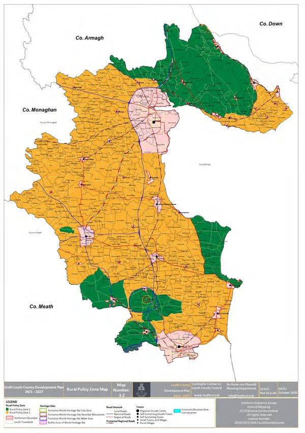
2.1.4 Landscape Character Assessment
The Green Infrastructure Strategy The Louth Landscape Character
recognises the need for Landscape Assessment (2002) identified 9 distinct
Character Assessment provision. One of character areas. These areas have been
its objectives is to promote the protection illustrated and detailed in Table 2 and
and management of the landscape Map 3. Applying the Landscape Character
character and provide enhanced Assessment to the Green Infrastructure
landscape settings for the built Strategy is advantageous in relation to
environment to ensure that new proposed large scale development in
development respects and blends into its areas of high scenic quality.
surroundings.
Table 2: Landscape Area Classification
International Carlingford Lough and Mountains including West Feede Uplands
National Boyne and Mattock Valley.
Regional Dundalk Bay Coast,
Dunany to Boyne Estuary Coast.
Uplands of Collon and Monasterboice.
Local Cooley Lowlands and Coastal Area.
Lower Faughart. Castletown and Flurry River Basins.
Louth Drumlin and Lake Areas.
Muirhevna Plain.
Page 12 of 46Appendix 8
Green Infrastructure Strategy
Map 3: Landscape Character Areas
Page 13 of 46Appendix 8
Green Infrastructure Strategy
These landscape character areas have should not be unduly damaged. Areas of
been transcribed in the development plan High Scenic Quality (AHSQ) and Areas of
through the designation of two distinctive Natural Outstanding Beauty (AONB have
areas. These areas have been afforded been designated for protection as
local protection through the policies of sensitive areas in the Development Plan
the Development Plan where the based on the Landscape Character
character of each of the landscapes Assessment.
2.2 BLUE INFRASTRUCTURE
2.2.1 Wetlands and Watercourse
The inclusion of the wetlands and water Additional potential for accessible
courses within this Strategy is important leisure facilities.
for connectivity from the coastline It is a policy of the local authority to
through into the wider countryside. This implement the EU Water Framework
is typically referred to as Blue Directive (WFD). Louth falls within two
Infrastructure. The protection of riparian river basin districts namely:
corridors abutting watercourses can Neagh Bann River Basin District
further integrate linear corridors into the (NBRBD), and
ecological network. Attenuation ponds, Eastern River Basin District (ERBD).
swales and reed beds provide many Water management plans for good future
advantages including: coastal and estuarine water for the two
Natural ways to reduce flood risk, districts must be adhered to.
Provide temporary storage, The rivers listed below must be protected
Improve water quality, and supported within a green
Create wetland habitats for wildlife infrastructure strategy to allow movement
in an attractive aquatic setting, and and flow of species and habitats
throughout the county.
Table 3: Main Rivers of County Louth
Location Rivers Qualities
Flows from Carlingford Mountain and enters
River Big
into Dundalk Bay.
North Louth
River Flurry and Source at Ravensdale and enters into Dundalk
River Ballymascanlan Bay at Bellurgan embankment.
Dundalk Castletown River Flows into Dundalk Bay at the mouth.
Runs from Knockbridge and enters Dundalk Bay
South Dundalk River Fane
south of Blackrock Village.
River White, Dee The River White and Glyde connect to the River
and Glyde Dee to enter Dundalk Bay.
South Louth Termonfeckin River River enters the Bay at Termonfeckin.
Maddock River flows from Meath and enters
River Boyne
the bay at Drogheda.
Page 14 of 46Appendix 8
Green Infrastructure Strategy
2.2.2 Wetland Survey
Wetlands include watercourses and water Louth County Council, with funding from
bodies as well as other habitat types the Heritage Council, commissioned a
including, fens, heathland, cutaway and survey of all known and potential
other areas including coastal and wetlands in the county. This Louth
estuarine salt marshes, dune slacks etc. Wetland Survey was a three year project
are influenced by the marine. They tend (2011, 2012 and 2014), which determined
to have high biodiversity value supporting the wetland status of approximately 308
a variety of habitats and species, function sites, considered likely to support wetland
in the protection of water quality and/or habitats on the basis of underlying soils,
flood control, serve as important carbon topography, historical mapping and aerial
stores contributing to climate resilience, photography. The survey documented the
filter pollutants and provide potential location, extent, and threats facing and
recreational opportunities. conservation ranking of virtually all the
While many protected areas include wetland sites in the County, in addition to
wetlands, most wetland areas occur presenting recommendations for their
outside protected sites. Globally, wetlands maintenance, management and
are protected by the Ramsar Convention. conservation.
Within Louth, only Dundalk Bay is listed as Details of the mapped sites, their ranking
a Ramsar site. However, it should be and associated written reports can be
noted that in County Down, the northern accessed on the Louth County Website at
section of Carlingford Lough, which is a the following links: Louth Wetlands 2011,
shared site, is also listed under the Ramsar Louth Wetlands 2012, Louth Wetlands
Convention. Many of the SACs and SPAs in 2014
County Louth referenced previously and
above, are wetlands.
Page 15 of 46Appendix 8
Green Infrastructure Strategy
Map 4: Watercourses, County Louth
Page 16 of 46Appendix 8
Green Infrastructure Strategy
2.2.3 Coastline
The coastline of Louth stretches from the and to address the necessity of adaptation
County Armagh border, through to climate change. With climate change,
Carlingford Lough, Dundalk Bay and as far sea levels will rise and increased storm
south as the Boyne Estuary south of intensity and surge will affect wetlands
Drogheda. The coastline is an important and coastal communities. The use of
resource to protect and is one which is green infrastructure and its protection can
also subject to erosion from sea level rises alleviate some of the impacts associated
due inter alia to climate change. Our with climate change by, for example,
existing coastal protection measures are integrating solutions for flooding.
located along the coast line at Blackrock, National guidance can be incorporated
Salterstown, Port Beach, Baltray and into this strategy to provide a stronger,
Bellurgan. In addition further measures clear process for climate- change proofing
may be required at other locations as the of the Development Plan. Mitigation
need arises. measures such as green building measures
Section 10 (2) (n) of the Planning and and less carbon intensive forms of
Development Act 2000 Act highlights the development and adaptation measures
need to reduce the overall quantity of such as flood risk assessment can be
anthropogenic greenhouse gas emissions referenced.
2.3 BIODIVERSITY
The support and protection of biodiversity been listed according to their importance
is critical for the function of green both at a European Level and National
infrastructure. The protection of habitats Level. The green infrastructure network
and species is an integral part of this aims to support both designated wildlife
Strategy. The habitats and species have and other habitats of local importance.
2.3.1 European Sites (Natura 2000 sites)
Louth has 11 European Sites which have Areas’ for the purposes of the green
been protected under the EU Habitats infrastructure strategy and the movement
Directive (Council Directive 92/43/EC) and and flow of species between these core
the European Community Birds Directive areas into the adjoining open countryside,
(Council Directive 79/409/EC) as per Table is of high importance.
4. These sites are identified as ‘Core
Page 17 of 46Appendix 8
Green Infrastructure Strategy
Table 4: List of European Sites within County Louth
Site Site
Name SAC Designation Name SPA Designation
Code Code
SAC Coastal SPA Coastal
Dundalk Bay 000455 Dundalk Bay 004026
/Estuarine /Estuarine
Carlingford Carlingford
002306 SAC Coastal 004078 SPA Coastal
Shore Lough
Carlingford SAC Stabannan– SPA Alluvial
00453 004091
Mountain Mountain Braganstown Plain
SPA
Clogherhead 001459 SAC Coastal Boyne Estuary 004080 Coastal/
Estuarine
Boyne Coast River Boyne and SPA
001957 SAC Coastal 004232
and Estuary River Blackwater Estuarine
River Boyne and
SAC
River 002299
Estuarine
Blackwater
Page 18 of 46Appendix 8
Green Infrastructure Strategy
Map 5- Special Areas of Conservation (SACs)
Page 19 of 46Appendix 8
Green Infrastructure Strategy
Map 6- Special Protection Areas (SPAs)
Page 20 of 46Appendix 8
Green Infrastructure Strategy
2.3.2 National Parks and Wildlife Service Conservation Plans
The National Parks and Wildlife Service Each European Site includes conservation
(NPWS) are the competent authority for objectives for which either the SAC or SPA
the purposes of regulation and control of is listed and full details in this regard are
operations within the European Sites. available on the NPWS website.
2.3.3 Proposed Natural Heritage Areas (pNHA)
The Louth County Development Plan the natural environment. These are
2021-2027 includes 24 proposed Natural outlined in Table 5 and Map 7 below.
Heritage Areas These sites can be integrated into a
(pNHA). These areas have been identified coherent green infrastructure strategy for
by the NPWS and include sites which are Louth and support a resilient ecological
of outstanding national importance for network.
Table 5: Proposed Natural Heritage Areas (pNHA)
Ref. Location Ref. Location
NH1454 Ardee cutaway bog NH 455 Dundalk Bay
NH1801 Barmeath Woods NH1806 Kildemock Marsh
NH1293 Blackhall Woods NH1804 King Williams Glen
NH1957 Boyne Coast and Estuary NH1451 Liscarragh Marsh
Louth Hall and Ardee
NH1862 Boyne River islands NH1616
Woods
NH452 Carlingford Lough NH1464 Mellifont Abbey Woods
NH453 Carlingford Mountain NH1805 Ravensdale Plantation
NH1458 Castlecoo Hill NH1828 Reaghstown Marsh
NH1459 Clogherhead NH456 Stabannan- Braganstown
NH1461 Darver Castle Woods NH1803 Stephenstown Pond
Drumcah, Toprass and
NH1462 NH1468 Trumpet Hill
Cortial Loughs
NH1856 Dunany Point NH1465 Woodland at Omeath Park
Page 21 of 46Appendix 8
Green Infrastructure Strategy
Map 7- Proposed Natural Heritage Area (pNHA)
Page 22 of 46Appendix 8
Green Infrastructure Strategy
2.3.4 Important Protected Species within County Louth
Important species in Louth should be biodiversity and integration for decision
included in any green infrastructure making. Details are available in the Draft
analysis due to the importance for Louth Biodiversity Plan 2020-2025.
2.3.5 Hedgerows
Hedgerows are an important element of hedgerow for the provision of a one-off
the Irish landscape and provide an house represents a major pressure on
important wildlife habitat. Hedgerows hedgerow destruction. For this reason the
host a wide range of plant and shrub retention of existing hedgerows is
species including insects, birds and promoted and encouraged during the
mammals all of which combine to support development management process.
green infrastructure. The retention of Where however this is not possible any
existing hedgerows and the promotion of permitted replacement should be in the
native planting for replacement form of a variety of native species such as
hedgerows supports habitats for animals hawthorn and blackthorn with supporting
which arable land or change in land use species such as holly, hazel and wild
fails to support. The removal of a cherry.
2.3.6 Trees
Trees, woodlands and hedgerows significant role in carbon storage. The
contribute greatly to Louth’s natural County Louth Development Plan 2021-
landscape character and biodiversity. They 2027 currently includes details of the 6
provide visual amenity in the rural and Tree Preservation Orders made within the
urban environment, shelter and clean air, County in addition to a comprehensive
important habitats for many species of listing of the 141 Trees and Woodlands of
wildlife and as high biodiversity habitats Special Amenity Value all of which are
they are key for both climate mitigation detailed in Chapter 8.
and adaptation measures, playing a
Page 23 of 46Appendix 8
Green Infrastructure Strategy
Map 8: Trees & Woodlands of Special Amenity Value
Drogheda (9), Dundalk (10), Ardee (11))
Page 24 of 46Appendix 8
Green Infrastructure Strategy
2.4 BUILT HERITAGE
2.4.1 Built Heritage
Elements of built heritage can make have value to green infrastructure include
substantial contributions to green e.g. heritage sites and gardens, designated
infrastructure. Built heritage sites that landscapes and old graveyards.
2.4.2 Heritage Gardens and Designed Landscapes
The National Inventory of Architectural Landscapes within County Louth. These
Heritage (NIAH) conducted a survey listing are identified in Table 6.
93 Heritage Gardens and Designed
Table 6: Historic Gardens & Designed Landscapes
Ballymascanlan House,
Allardstown, Beaulieu House,
Ardee District House, Black Hall
An Grainin,
A Arthurstown House, B Barmeath Castle,
Bellurgan Park,
Anaverna House, Braganstown House
Ashville Barronstown Rectory
Beltichburne
Cardistown House, Castletown
Darver Castle,
House
Doolargy House,
Claret Rock House, Coolestown Dromiskin House,
Stud, Dun Luighaidh Convent,
Corderry House, Dellin House,
C Carstown,
Catherines Grove,
D Dowdstown House,
Drumcashel House,
Clermont Park, Dunany House,
Corbollis House, Derryfalone House,
Castlebellingham Dromin,
Charleville, Drummullagh House
Clonaleenaghan House
G Glyde Court, H Harristown House
Kildemook House,
Killin,
Killincoole,
I Icehouse Hill Park, K Killineer House
Kitallaght House
Knockabbey Castle
Page 25 of 46Appendix 8
Green Infrastructure Strategy
Maine House
Monasterboice House
Lisnawully House Mount Bailey
L Louth Hall
Lisrenny House M Milestown House,
Monavallet House
Listoke House Mount Oliver Convent
Milltowngrange House
Mooremount House
New Mellifont Abbey Park Hotel
Piperstown House
Nootka Lodge
N Newtown Darver P Park Inn Hotel,
Prospect
Newtown House Philipstown House
Rahanna House
Shanlis House
Rathcoole House
Smarmore Castle Hotel
Ravensdale House
Stephenstown House
Rokeby Hall
Shortstone House,
R Rath House,
Rathescar, S Spencer Hill,
Stickillin House
Red House
Shortstone West,
Rathbrist House
St Marys Hospital
Rathneestin House,
Stone House
Richardstown Castle
The Grove
T Thistle House
Townley Hall
W Williamstown House
2.4.3 2.4.3 Protected Structures and Architectural Conservation Areas
(ACA)
County Louth has a wealth of architectural Conservation Areas (ACA’s) An ACA is an
heritage which constitutes an important area, group of structures, or a townscape
element of our culture. The Local which is of special architectural, historical,
Authority has a legal responsibility to archaeological, artistic, cultural, scientific,
include a Record of Protected Structures social or technical interest or contributes
(RPS) in its County Development Plan and to the appreciation of protected
this is available in Volume 4. Protected structures. There are currently 18 ACAs in
structures within a country setting can be Drogheda, 8 in Dundalk and 10 identified
supported by demesne landscapes and in the County. Details of the ACAs within
large curtilage areas. Buildings of the County are available in Chapter 8 and
conservation interest may be grouped in Appendix 11 and 12, Volume 3.
together and referred to as Architectural
Page 26 of 46Appendix 8
Green Infrastructure Strategy
2.4.4 Monuments and Archaeology
The Record of Monuments and Places past and also our future. Portions of the
(RMP) is the official record of Buffer Zone of the Brú na Bóinne UNESCO
archaeological sites and monuments in World Heritage Site and the Battle of the
Ireland. Within County Louth there are in Boyne site in addition to the Tentative
excess of 1,500 Recorded Monuments World heritage Site of Monasterboice are
which are afforded protection under the located within County Louth.
National Monuments Acts. Such Development and its impact on these
monuments are vulnerable to change in important sites and the surrounding areas
land use and development. This finite must be considered into the future.
resource is an important part of both our
Page 27 of 46Appendix 8
Green Infrastructure Strategy
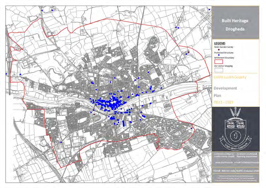
Map 9: Built Heritage – County Louth
Page 28 of 46Appendix 8
Green Infrastructure Strategy
Map 10: Built Heritage – Drogheda
Page 29 of 46Appendix 8
Green Infrastructure Strategy
Map 11: Built Heritage – Dundalk
Page 30 of 46Appendix 8
Green Infrastructure Strategy
Map 12: Built Heritage – Ardee
Page 31 of 46Appendix 8
Green Infrastructure Strategy
3 GOING FORWARD: THE GREEN INFRASTRUCTURE STRATEGY
The Green Infrastructure Strategy aims to 4, Small Towns and Villages in the
strengthen and/or create wildlife County,
corridors between interconnecting core 3. Proposals for detailed green
areas for the benefit of biodiversity, infrastructure in the LAP’s for
enhanced outdoor recreational Drogheda and Dundalk,
opportunities, visual amenity and general 4. Provision of guidance for support in
wellbeing. This Green Infrastructure spatial planning and integration of
Strategy approach proposed for County green infrastructure into local
Louth will consist of: development proposals and
1. Support for the existing green throughout all relevant aspects of the
infrastructure network, Development Plan.
2. Enhancement of green infrastructure This green infrastructure strategy has
throughout the five Level 3, Self- been further detailed below.
Sustaining Towns and the eight Level
3.1 GREEN INFRASTRUCTURE NETWORK
The interconnected ecological network from Section 2 of this strategy and
which includes core areas, corridors, provides a baseline assessment on a
stepping stones and buffer areas county wide basis. The green
comprises the Green Infrastructure infrastructure network provides a
Network for County Louth which is strategic overview of the current linkages
illustrated on Map 12. This represents the to be retained and protected.
amalgamated environmental components
Objective
To support the green infrastructure network of County Louth and ensure its
GI 1 implementation in the assessment of all development proposals to prevent
adverse impact on the ecological connectivity of County Louth’s Core Areas.
Page 32 of 46Appendix 8
Green Infrastructure Strategy
Map 13: Green Infrastructure Network
Page 33 of 46Appendix 8
Green Infrastructure Strategy
3.1.1 Appropriate Assessment (AA)
Map 12 above is a tool which can be European Site (Special Area of
utilised to assist with the assessment of Conservation (SAC) or Special Protection
development proposals which may impact Area (SPA)) would consider the ecological
on European Sites for Appropriate connectivity of a proposed development
Assessment (AA). The assessment of likely site to a SAC/SPA.
effects of a development proposal on a
Objective
GI 2 To require the use of and develop the green infrastructure network to ensure
the conservation and enhancement of biodiversity and as a supplementary
guide for the protection and conservation of the European Sites in County
Louth.
3.2 3.2 SPATIAL PLANNING
The key accomplishment of a green 2. Provision of green infrastructure
infrastructure network is the provision of strategies in the LAP’s for Drogheda
a new framework which identifies the and Dundalk,
constituent parts of the network and 3. Enhance and support the green
provides a strategic approach to land infrastructure strategy in Level 3 and
conservation, given the priority of the 4 settlements in the Louth County
natural environment. Appropriate support Development Plan 2021-2027,
measures will be made available for the 4. Support for Green infrastructure at
natural environment through the local level decision making through all
following: relevant sections/aspects of the Louth
County Development Plan 2021-2027.
1. Prioritisation of lands within the core
strategy,
3.2.1 Core Strategy
The Core Strategy requires that lands are The Habitats Directive (HD
prioritised and compliant with the 91/43/EEC) regarding the protection
requirements of the following: of Louth’s natural environment.
Strategic Environmental Assessment The evidence based assessment of land
(SEA 2001/42/EC), allocation will support the GI Base and the
The Water Framework Directive (WFD overall network Figure 3 will be used for
2000/60/EC,) the core strategy.
Page 34 of 46Appendix 8
Green Infrastructure Strategy
Figure 3: Core Strategy and Integration and Compliance with Green Infrastructure
Residential lands shall be prioritised based on resources within urban areas and settlements
the availability of lands and sustainable will enable the prioritisation of lands for
development. The provision of valuable development.
Objective
GI 3 To utilise all information available on the Louth Baseline Assessment as
evidence based decision making in the Louth Core Strategy
3.2.2 Level 3 and Level 4 Settlements
The five Level 3 and eight Level 4 developments. It should be noted that
Settlements in County Louth were their inclusion does not prevent the
assessed for current green infrastructure promotion or development of other such
and include features of interest such as areas for potential green infrastructure.
the existing open space areas, those trees Table 7 provides an overview of the green
and hedgerows identified as having infrastructure in the five Level 3 and eight
special amenity value and riparian Level 4 Settlements and should be read in
corridors. Additionally possible areas for conjunction with the objectives maps
potential upgrading of green associated with each individual settlement
infrastructure have been identified within and available in Volume 2. Development
these settlements as “Areas for potential management proposals within these
green infrastructure enhancement”. settlements should be assessed having
These areas should be used for regard to the Development Management
development management decision Guidance in Section 3 of this strategy.
making and integrated into proposed
Page 35 of 46Appendix 8
Green Infrastructure Strategy
Table 7: Assessment of Green Infrastructure within the Level 3 and 4 Settlements
Potential for Green Infrastructure
Settlement Features of Interest
Enhancement
River Glyde;
Protection of coastline;
Coastline;
Riparian corridor retention
SAC/SPA;
Annagassan Additional supporting planting along the
Strategic reserve and 4 areas
road lines, between open spaces and
of designated public open
into the countryside.
space;
ACTION
A. Roadside planting schemes along the main road
Important hedgerows, if removed, to be integrated into any submitted design.
Coastline;
Core area (Natura site) with ecological
SAC/SPA;
Baltray corridors retained along road frontages
Open space network
and into the countryside.
throughout the settlement.
ACTION
A. Promote connectivity between the coastline and public open space within the village
of Baltray.
B. Retain current roadside planting along a main route in Baltray and promote the
enhancement of additional planting.
Coastal location;
Large expanse of open space
Core area of SAC/SPA along the
designation;
coastline is to be supported by open
Carlingford Trees and views to be
space designations and ecological
protected;
networks via trees and hedgerows.
Number of intact roadside
treatments.
River Glyde through the The central village area is lacking in
Castlebellingham village; greenspace or planting and would
& Kilsaran Large expanses of designated benefit the overall quality and public
open space lands; realm through more interconnectivity.
ACTION
A. Additional supportive planting throughout the village centre to link the river and
countryside.
Area of Outstanding Natural There is very little quality green
Clogherhead Beauty (AONB) infrastructure within the Clogherhead
SAC/pNHA settlement and integration into any
Page 36 of 46Appendix 8
Green Infrastructure Strategy
Potential for Green Infrastructure
Settlement Features of Interest
Enhancement
Public open space future upgrade is essential.
A.
Presence of New Mellifont
Abbey Woods pNHA,
Roadside planting along identified
Abundance of trees proposed
growth areas out of the centre;
Collon to be protected within the
Protection of green spaces and riparian
centre.
corridors.
The presence of stone walls
and banks.
ACTION
A. Inclusion of roadside planting and native planting schemes within any proposed
developments.
Expanses of strategic land
reserve with mature planting
Native planting and enhancement
Dromiskin and hedgerows;
schemes.
Open space, places of worship
and graveyards located close,
ACTION
A. Integration of green infrastructure throughout the village centre providing
connectivity
Central provision of open
space with abundance of Consolidation of GI within future
Knockbridge
mature hedgerows and mature enhancement schemes.
trees.
A.
Abundance of open space and Provision of appropriate integration of
Louth Village amenity throughout the proposals into future residential
village. development.
A.
SAC/SPA Support for the core area and
Omeath The Coastline, protection of green routes through into
Adjoining pNHA, the countryside.
A.
River Glyde flows through the
central area with important
Protection of existing important
Tallanstown riparian corridors.
biodiversity areas.
Good quality open spaces;
Important hedgerows and
Page 37 of 46Appendix 8
Green Infrastructure Strategy
Potential for Green Infrastructure
Settlement Features of Interest
Enhancement
trees.
A.
Riparian Corridor,
Public open space and domain,
Biodiversity enhancement Protect the existing green infrastructure
Termonfeckin
schemes; network throughout the settlement.
Protection of trees and
hedgerows.
A.
Adjoining SAC/SPA;
Protection of open space to allow the
Tullyallen Abundance of open space
support and connectivity of core areas
provision.
ACTION
A. Roadside boundary treatment.
Objective
To support the existing features of interest in the Level 3 and Level 4
GI 4 Settlements of County Louth and promote and facilitate any areas identified for
green infrastructure enhancement.
Page 38 of 46Appendix 8
Green Infrastructure Strategy
The following features of interest should Protecting stream banks from
be supported, not only within the erosion,
identified settlement areas but also Providing a storage area for flood
outside of these boundaries and waters,
throughout the countryside. Providing food and habitat for fish
Riparian Corridors: A riparian corridor is a and wildlife,]and
unique area along a river, stream, lake or Preserving open space and aesthetic
waterbody which serves to support the surroundings.
natural environment through: Riparian corridors are fragile areas which
Preserving water quality by filtering are recognised for their contribution to
sediment from run-off prior to green infrastructure.
entering rivers and streams,
Objective
GI 5 To ensure that no development including clearing or storage of materials takes
place within a minimum distance of 10m measured from each bank of any river,
stream or watercourse
Landscape Features: Landscape features value. These features shall be retained in
of importance in each of the settlements any proposed developments and in any
have been listed and these can form an event where this is not possible, the
essential part of an ecological network Planning Authority will require the
within an overall context. These features relocation of stone walls and/ or planting
include trees, hedgerows, stone walls and of hedgerows and trees.
Louth banks which have special amenity
Objective
GI 6 To incorporate all identified stone walls into development proposals. Where
retention of the stone wall is not feasible there shall be a requirement to
rebuild the stone wall at an alternative, suitable location.
3.2.3 Level 1 Settlements: Drogheda and Dundalk
In addition to the overall green Objectives to be included within the LAPs
infrastructure network of the County, an will enhance the quality of life of the
in-depth assessment of the features of residents by affording support for existing
interest in urban areas can further and proposed green infrastructure. These
support quality of life. Additionally green objectives for the identified urban areas
infrastructure baseline assessments will will be comprehensive in nature and will
be provided for in the LAPs for Dundalk be based on the following strategic
and Drogheda following the adoption of objectives:
the Louth County Development Plan 2021-
2027 and the subsequent review of these
plans.
Page 39 of 46Appendix 8
Green Infrastructure Strategy
1. To create a high quality, well- 4. Integration of green infrastructure
connected and sustainable natural features to combat climate change
environment of green spaces and impacts and flood control such as
watercourses based on linkages by green corridors, green roofs and
footpaths and cycleways, native planting.
2. Promotion of a high quality, well- Table 8 provides an example of the
connected and sustainable urban area objectives which may be included within
with flexible, multi-functional places the identified LAP’s and which may
to enhance local distinctiveness and transpire as policies and actions for the
character for e.g. use of trees and urban areas. The delivery of these
planting within public spaces, features and green infrastructure should
3. Protection of high value habitats and also be linked into operational plans for
support for the enhancement of these areas.
habitats of local importance,
Table 8: Objectives to be included for LAPs
Feature Green Infrastructure
Greenways Provision of planting schemes in conjunction with planned pedestrian and
cycle routes. Where these are planned within landscaped areas caution will
be taken to retain mature planting already in place.
Public Realm The enhancements of existing public spaces as green infrastructure “hubs”
which can encourage use of these areas by the public. Integration of green
environments within hospitals and health centres.
Biodiversity Planting schemes with regeneration schemes and roads infrastructure. The
use of vacant and derelict land as set aside areas and/ or rewilding. Native
planting required in all landscaping schemes for proposed developments.
Climate Integration of Sustainable Urban Drainage Systems (SUDS) into all
Change developments and policies to reflect this integration. Identified flood area
to be addressed within the core strategy and used as an important aspect
of the overall green infrastructure network for urban areas. Flood defence
works should benefit the green infrastructure network.
Objective
To prepare specific Green Infrastructure Strategies for the Regional Growth
GI 7 Centres of Drogheda and Dundalk and integrate into the Local Area Plan for
each settlement.
Page 40 of 46Appendix 8
Green Infrastructure Strategy
3.2.4 Development Management Guidance
3.2.4.1 Development Proposals
Developments proposed at a local level recommendations which can be included
have an opportunity to put strategic within any development proposals to
objectives into practice. These proposals enhance the environment should be
may be further advanced within the LAP’s incorporated and cognisant of the
but should not be precluded from any promotion and integration of green
other areas within County Louth. Louth infrastructure to enhance the quality
County Council promotes green character and design of the proposal.
infrastructure integration based on Table 10 below can be used during the
Biodiversity, assessment of a development proposal.
Landscapes, The advantage of this relates to the
Open spaces, parks and recreation; retention and enhancement of existing
Heritage, green infrastructure and supports these
Water management. overall policies and objectives for
Following on from the green enhancing the quality of life.
infrastructure baseline assessment,
3.2.4.2 Environmental Enhancement
a) Assessment and enhancement of biodiversity features for development proposals
should have regard to the following assessment included within Table 9.
Table 9: Summary of the Survey of Existing Biodiversity Features
Features Description
Surrounding land The Corine Land Cover (CLC 2018) indicates that at level 3?? the plan
cover and area includes land uses such as pasture, non- irrigated land, and
landscape discontinuous urban fabric and sport and leisure facilities. The Louth
character Landscape Character Assessment includes 9 areas of character which
can help shape development proposals.
Connecting Green networks: Protection and/or integration of important hedgerows
Features & treelines into development proposals.
Green routes: Inclusion of environmental enhancement features along
the main connection route throughout urban areas and settlements in
conjunction with green infrastructure such as cycle, pedestrian and bus
routes.
Biodiversity The inclusion of the green infrastructure assessment and proposals can
Review provide great value for biodiversity and support movement of species.
This includes the retention of valuable hedgerows, Louth banks and
nature corridors. They can be further enhanced by integrating with
green routes, walkways cycleways etc.
Page 41 of 46Appendix 8
Green Infrastructure Strategy
Features Description
Louth is particularly rich with biodiversity due to its location along the
coast, beside an SAC/ SPA, the number of amenity spaces, the existing
and proposed recreational areas and the agricultural lands. Any
development proposals should enhance rather than remove features of
interest.
Integration of Habitats: Those of importance have been identified as green spaces or
habitats valuable habitats, as illustrated in the green infrastructure network and
the settlement maps. They have the potential to contribute to the
overall environmental quality of the Plan area, in addition to supporting
the ecosystem services of the County.
Any development proposals should integrate these habitats of
importance according to “A Habitat Guide in Ireland” (Fossit, 2000).
Valuable habitats can support the SPA, SAC and provide additional
support areas and valuable ecosystem services by preventing
fragmentation.
Features of Green Space: Aside from the existing green spaces provided within the
Value Plan area a number of additional areas are identified as features of
value, as listed below. These should be retained and developed in
tandem with future development proposals.
Public Green Space: Public green space provision in the settlements can
enhance the quality of life for the residents with additional open space
areas integrated into residential areas.
A centrally located park can provide a range of facilities and prove to be
favourable with the resident’s. It should be well located and supported
by good linkages to surrounding areas and integration of additional
planting.
Private Green space: Unbuilt areas and gardens can benefit public
health by providing informal passive recreation opportunities. The
opportunity exists to incorporate valuable private garden areas to
enhance economic value of residential developments.
Trees: A number of trees and groups of trees of value may be subject to
a Tree Preservation Order.
Hedgerows: Hedgerows of importance have been mapped as important
green infrastructure and shall be retained and incorporated into any
proposed development areas.
Wetlands & Watercourse: Support the environmental qualities of the
area and other features of value.
Page 42 of 46Appendix 8
Green Infrastructure Strategy
Objective
All future development proposals shall require, within the overall design
scheme, the integration of environmental assets and existing biodiversity
GI 8
features including those identified in Table 9 of the Green Infrastructure
Strategy, to enhance the quality, character and design of the proposal.
3.2.4.3 Landscape Design and Planting
Land use planning objectives transferred appropriate landscape layout can be used
into a development proposal can in the first instance in any masterplan
incorporate useable green infrastructure schemes or proposals such as those
proposals for the benefit of the proposed illustrated in Figure 4.
developments. The integration of
Figure 4: Masterplan Proposals and Links to Proposed Development from the City of
Stockholm
Following on from the overall landscape provided should include native planting
design and support for the green such as tree planting referred to in Table
infrastructure network, the detail 10.
Table 10: Native Planting Scheme
Aspect Detail
Tree Structure/ Native trees to Ireland include :
species-richness Alder, Ash, Aspen
Birch Silver, Birch Downey
Cherrywild
Hazel, Hawthorn, Holly
Oak Pedunculate, Oak Sessile
Rowan
Page 43 of 46You can also read